Note: Descriptions are shown in the official language in which they were submitted.
CA 03129194 2021-08-05
WO 2020/162759 PCT/N02020/050018
1
Method for establishing a consolidated water current velocity profile
The present invention relates to a method for determining a water current
velocity profile in a water column by registration of a deviation between a
first
position and a second position of an underwater vehicle travelling in the
water
column, said method comprising deploying a batch of underwater vehicles ¨
comprising at least one vehicle - from a surface vessel into the water, said
vehicle steering to the first position which for the first batch is a
predefined
estimated position (PEP) calculated by a first predefined water current
velocity profile.
In the marine environment, seismic data has conventionally been collected
by towing long streamers of receivers and energy sources (typically acoustic
energy) behind a surface vessel or a separate source vessel. During the
past decade, independent ocean bottom receivers called 'seismic nodes'
have been developed. Nodes record seismic data actively and continuously
from the time, they are deployed on the seafloor.
In general, the seismic nodes are independent seismometers and are self-
contained units. They comprise a housing, or a set of individual housings,
that comprises various internal components such as geophone, hydrophone
sensors, a recorder, a memory for storing the seismic data, a clock for time
synchronization, and a power source.
While a cable, wire or rope connecting the seismic nodes determines the
inline distance between seismic nodes, it does not ensure that the seismic
nodes are deployed along a predetermined path. Further, when a plurality of
seismic nodes attached to a cable is deployed in the sea, it is required to
know the position of the cable and the positions of the seismic nodes during
and after deployment.
The standard Nodes can either be deployed by an Remotely Operated
Vehicles (ROVs) operated from a surface vessel, or by attaching the seismic
CA 03129194 2021-08-05
WO 2020/162759 PCT/N02020/050018
2
nodes to a cable or a rope or a wire. Many other towing members are
deployed from a vessel. These vessels may be configured to monitor the
deployment of a plurality of seismic nodes. Further, the sensor data provides
a current profile.
Current meter measurement equipment is today costly to purchase and
expensive to install and operate for longer profiles measurements, i.e. in
deeper waters, the sensor beam-pattern frequency is low and equipment
physically heavier and voluminously larger. Measurement accuracy and
resolution is dependent on environmental condition, such as weather (waves
and wind), pressure-, temperature-, oxygen- and salt ratio, and installation
quality.
Alternatively, cumbersome installation on the seafloor, fixed with the sensor-
beam facing upwards, or mechanically integrated on the ship hull or on a
through-hull sensor pole extending downwards is used.
Acoustic Doppler current profilers (ADCP) are types of sonar that attempt to
produce a record of water current velocities, and direction, over a range of
depths. The most popular acoustic Doppler current profilers use a scheme of
four transducers. They produce mono-frequency sound pulses traveling
through the water in four different, but known directions. If the acoustic
Doppler current profiler is looking down into the water, each transducer would
be aligned at 12, 3, 6 and 9 o'clock positions facing away from the perimeter
of the clock. These are tilted down 90 degrees in elevation below the horizon.
As chatters in the water return the echo of the sound, it is shifted in
frequency
due to the Doppler Effect. In addition to the transducers, the acoustic
Doppler
current profiler typically has a receiver, an amplifier, a clock, a
temperature
sensor, a compass, a pitch-and-roll sensor, analog-to-digital converters,
memory, digital signal processors and an instruction set. The analog-to-
digital converters and digital signal processors are used to sample the
returning signal, determine the Doppler shift, and sample the compass and
other sensors. Trigonometry, averaging and assumptions are used to
CA 03129194 2021-08-05
WO 2020/162759 PCT/N02020/050018
3
calculate the horizontal velocity of the group of echoing scatters in a volume
of water. By repetitive sampling of the return echo, and by "gating" the
return
data in time, the acoustic Doppler current profiler can produce a profile of
the
water currents over a range of depths.
The main disadvantage of the ADCPs is the loss of data close to the
boundary. This mechanism, often referred to as a side lobe interference,
covers 6-12% of the water column and, for instruments looking up toward
the surface, the loss of velocity information close to the surface is real
disadvantage. Cost is also a concern.
Further, the ADCP contributes to noise pollution in the ocean, which may
interfere with acoustic navigation and acoustic ranging.
A static alternative is a costly "real-time" sensor, with an extensive
complementary sensor portfolio, mounted on an autonomous- or remotely
controlled vehicle (DVL). For underwater vehicles, the bottom-tracking
feature can be used as an important component in the navigation systems.
In this case, the velocity of the vehicle is combined with an initial position
fix,
compass or gyro heading, and data from the acceleration sensor. The sensor
suite is combined (typically by use of a Kalman filter) to estimate the
position
of the vehicle. This helps to navigate submarines, autonomous and remotely
operated underwater vehicles. However, this is only a local effect and
benefit.
Therefore, it is desirable to be able to determine the full water current
profile
more precise, and thereby making it possible to navigate and positioning a
multiple of subsea units ¨such as vehicles and nodes - in a reliable and
accurate manner thereby increasing the effectiveness in the global
positioning of underwater nodes and minimizing the cost for this. Especially
the horizontal water current profile is important to determine as the vertical
seems steadier or limited and therefor reliably predictable.
The present invention seeks generally to improve the estimated water current
profile such that the abovementioned insufficiencies and drawbacks of
CA 03129194 2021-08-05
WO 2020/162759 PCT/N02020/050018
4
today's methods and systems are overcome or at least it provides a useful
alternative.
Up to this day, prior art has failed to teach a simple and yet reliable and
inexpensive method for determining a water current profile which in a safe
and reliable manner, without substantially increasing the cost is able to
satisfy the abovementioned much desired characteristics.
According to the invention,
a method is provided, as per the introductory part of this specification, and
wherein the vehicle by first means is recording the second position, which is
the actual position AP,
and the difference AP between the predefined estimated position PEP and
the actual position is registered, and based on said difference a deviation
data set is calculated, and an updated horizontal water current velocity UV is
determined in said water column.
The current profile could initially be a neutral current setting, i.e,
velocity=0
at all levels in the water column.
During a normal operation, numerous vehicles ¨ a batch - are dropped
simultaneously or at short intervals. They autonomously steer laterally, away
from the surface vessel vertical, based on a predefined hydrodynamic model/
digital twin corrected for real-time inertia measurements, compass and
pressure, towards a predefined location on the seafloor.
During the flight, the vehicle position is acoustically measured in semi real-
time, and a consolidated data set of the deviation from the estimated
positions - versus the measured position - is relayed acoustically to a
surface
and a PC or mainframe. These individually measured deviations, is
collectively used as a dataset for post-measurement processing, establishing
a complete water current profile.
The method utilize existing hardware and logged data and requires only a
topside CPU-capacity, and data storage, incl. a software patch for calculating
CA 03129194 2021-08-05
WO 2020/162759 PCT/N02020/050018
a complete- and high resolution water current profile. This high-resolution
water current profile is based on the most resent estimated/predefined
current profile and an actual water current velocity profile, which is used
for
defining the next estimated water current profile used for autonomous flight
5 control and navigation.
The water current profile is instantly available for the next batch of
vehicles
or underwater applications such as nodes.
The concept can also be used on an inter-chained node deployment system,
i.e. nodes attached to a wire, rope or cable, pre-requisite the capacity to
individually acoustically communicate bi-directionally.
Basically, this "high-resolution" current profile is obtained for free,
without the
need for new hardware and ¨ expensive installation and maintenance. In
addition, the support vessel does not require standing still to produce
reliable
measurements. The water current profile is used to better and more efficient
deploy nodes accurately to the seafloor or on their return to surface. On a
larger scale, this information may provide an improved 3D-model of the
water-current profile over a large area in terms of both vertical and
horizontal
resolution: A sub-meter resolution vertical profile every 100-500m in a
horizontal grid pattern, (over a 1500km2-survey area). The better the
estimated water current profile is the better the vehicles can be positioned
on
the seafloor and the better and more accurately the nodes can be deployed
with reduced use of hydro acoustics ranging, and hence cheaper and faster.
In other words the vehicle deployed for different purpose such as lateral
transporting different payloads are equipped with a device that records the
actual position and the deviation between the current profile of the estimated
path and the actual path is recorded and used for calculating a more precise
estimated position for the next batch of vehicles. The new estimated current
velocity profile is then used for deploying a new set of nodes more
accurately.
Typically, nine nodes are deployed each time comprising a full batch. Around
CA 03129194 2021-08-05
WO 2020/162759 PCT/N02020/050018
6
three thousand nodes are deployed in order to record a full seismic survey
grid. Therefore, it does not matter that the first series of nodes actually
are
deployed in a position that differs significantly from the intended and
correct
position as the feedback from these vehicles are making the subsequent
positioning more and more precise.
By the method, a consolidated water current velocity profile is obtained.
According to one embodiment,
the updated water current velocity UV is sent to a controller,
said controller is updating the predefined estimated position PEP to an
updated estimated position UEP based on the predefined estimated position
PEP and the updated water current velocity, and the said next batch of
vehicles dropped into the water are steering to the first position based on
the
updated estimated position UEP.
All nodes are calculating its unique trajectory to steer toward its pre-plot
position.
According to one embodiment,
every new batch of vehicles travelling in the water after the first batch of
vehicles is using the updated estimated position UEP calculated by the data
set obtained by a batch of vehicles recently deployed, said this position now
being the first position.
According to one embodiment,
the predefined estimated position PEP and the first position is based on a
digital twin hydrodynamic model and information data obtained by measuring
6-axis changes in inclination, acceleration and direction, and at least one
pressure sensor, recording pressure or water depth, and a compass for
measuring the vehicle heading.
According to one embodiment,
CA 03129194 2021-08-05
WO 2020/162759 PCT/N02020/050018
7
the actual position AP is determined by an acoustic transducer carried by the
vehicle in question said acoustic transducer is recording data in semi real
time.
Deviation between the first position - whether this is PEP or UEP - and the
AP will be recorded as means of measured ranges (LBLs ¨ Long base line
measurements) between the acoustic transducer placed on the vehicle in
question, and reference transponders on the surface, and/or in combination
with already installed vehicles on the seafloor ¨ being post landing
georeferenced relative to the support vessel and its GPS-equipment. The UV
position could also be obtained with a USBL positioning system from the
surface vessel.
The actual position AP is determined by acoustical position or range
measurements and geometrical triangulation.
Already installed drop-nodes/vehicles on the seafloor will be positioned by
the support vessel, and hence their positions globally referenced based on
the vessels GPS-position and heading.
According to one embodiment,
a profile for the water current velocity deviation is depicted in a 3D model
in
vertical and horizontal direction thereby providing a grid pattern.
This improves the position of devices deployed on the seabed and makes a
present, updated, and correct current profile available.
According to one embodiment,
the UV is calculated by a topside CPU-capacity such as a computer
comprising a software patch, said UV is used for calculating an updated
estimated position UEP as the first position.
Thereby an updated current profile is provided.
According to one embodiment,
a water current velocity deviation AD between the predefined estimated
CA 03129194 2021-08-05
WO 2020/162759 PCT/N02020/050018
8
water velocity current profile and a calculated water velocity current profile
is determined based on the data set.
According to one embodiment,
the first position and a first trajectory is determined by a data-set
comprising
a first water current data profile and the second position-and a second
trajectory is determined by data-set comprising a second water current data
profile.
According to one embodiment, each batch of underwater vehicles comprises
the same number of vehicles preferably 9 vehicles all travelling through the
water column towards the first position on the seafloor.
The invention is also related to use of the method according to the invention
for determining an improved and precise position when deploying nodes,
underwater vehicles and other devices into the water, and for determining a
precise position of nodes, underwater vehicles and other devices already
deployed in the water.
Brief description of the drawings
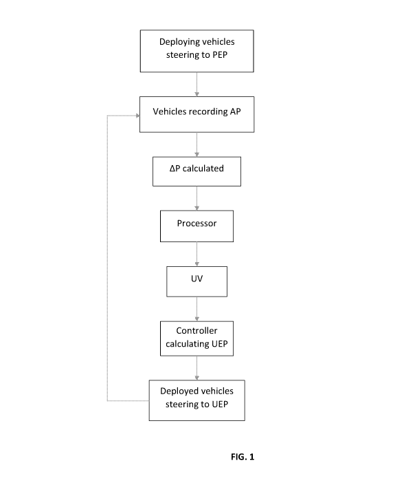
FIG. 1 is showing a flowchart of a method for navigating a batch of
underwater vehicles to a more precise position.
FIG. 2A is a sketch view of a vessel deploying a batch of underwater vehicles
into the water.
FIG 2B is a 2D view of a water current profile.
Fig. 3 is showing a flowchart of a method for navigating a batch of underwater
CA 03129194 2021-08-05
WO 2020/162759 PCT/N02020/050018
9
vehicles to a more precise position.
Fig 4 is showing a flowchart of a method for providing a 3D picture of a water
current profile provided by the method.
The invention will be explained with reference to fig. 1.
Fig. 1 is showing a flowchart of a process for navigating a batch of
underwater vehicles to a more precise position. A deviation AP is
determined and used for determining a more precise position: an updated
estimated position UEP¨ a first position ¨ for the next batch of vehicles.
The deviation between this first position and a second position AP is
determined. The second position is an actual position AP of an underwater
vehicle travelling in the water column. A batch of underwater vehicles ¨
normally 9 ¨ is deployed from a surface vessel into the water. The vehicles
are steering to the first position, which for the very first batch is a
predefined
estimated position PEP. This PEP is determined by an estimated water
current velocity profile. The estimated water current velocity profile is
based
on a hydrodynamic model, and information data obtained by measuring 6-
axis changes in inclination, acceleration and direction and at least one
pressure sensor recording pressure and a compass.
Each vehicle is by first means such as an acoustic transducer recording
the second position, which is the actual position AP.
The difference AP between the predefined estimated position PEP and the
actual position AP is registered, and based on said difference a deviation
data set is calculated. A water current velocity deviation AD between the
predefined estimated water current velocity profile and a calculated water
current velocity profile might also be determined.
The value of AP ¨ and when appropriate AD - is sent to a topside controller,
and the controller is updating the predefined estimated position PEP to an
updated estimated position UEP based on the predefined estimated
CA 03129194 2021-08-05
WO 2020/162759 PCT/N02020/050018
position PEP and the AP. The next batch of vehicles is dropped into the
water and are steering to the first position based on the updated estimated
position UEP. In this way the deviation between actual position AP and
planned position UEP will be less and less for an increasing number of
5 batches of vehicles deployed in the water.
FIG. 2A is a sketch of a vessel 1 deploying underwater vehicles 2 into the
water 3. The travelling of the vehicle through the water is shown by different
positions of the same vehicle and marked 2, 2', 2". The end position 4 is
10 where the vehicle 2" is placed. The AP is registered by using signals
from a
transducer and signals 6 from already deployed vehicles 5 placed on the
seabed. These vehicles 5 are also sending signals back to the vessel 1.
The predefined position PEP or predefined trajectory is shown with a dotted
line. The actual position AP is offset in relation to PEP. The advantages
are: less need for extensive acoustic ranging, date recording is up to date,
there is less flow and it is more accurate. Further, the digital twin is used.
Fig. 2B shows the current velocity profile in 2D that is the profile in
horizontal direction for different depths. In reality, this profile will be a
3-D
representation, taking compass heading of the current into consideration.
Fig. 3 is showing flowchart of a method for navigating a batch of underwater
vehicles to a more precise position. The flowchart also shows how
acoustics ranges are used in order to calculate the actual position.
A pre-plot position is received and the last-known GPS-position is also
registered. The information is used to upload the latest current profile and
calculate a trajectory. Then the vehicles are deployed and steering towards
the pre plotted position. The actual position is determined based on
acoustics information and the value of AP is now calculated and stored.
This value is the used for the next batch of vehicles.
CA 03129194 2021-08-05
WO 2020/162759 PCT/N02020/050018
11
Fig 4 is showing a flowchart of a method for providing a 3D picture of
consolidated water current profiles provided by the method. AP is registered
at certain depths for a number of vehicles and is used for calculating an
updated 3D current profile topside. This 3-D current profile is then uploaded
and used by nodes to be deployed later.