Note: Descriptions are shown in the official language in which they were submitted.
CA 03138261 2021-10-27
WO 2020/222652
PCT/N02020/050101
- 1 -
Method of estimating a mineral content of a geological structure
The present invention relates to the field of seabed mineral exploration. In
particular, in relates to a method of estimating a mineral content of a
geological
structure, for example for seabed mineral exploration.
Seabed minerals such as metal sulphides can be valuable. However,
mining for them, particularly in subsea locations, is difficult and expensive.
Valuable minerals, such as metal sulphides, are often found around so-
called "black smokers". If a black smoker is found, for example by chance, a
rock
sample may be taken from around the black smoker for analysis in a laboratory,
to
see whether sought-after minerals, or a sufficient (e.g. economically viable)
level of
such minerals, are present at that location. Valuable minerals, particularly
around
black smokers, are often present in much higher concentrations in sea-bed
locations than in onshore locations. However, due to the cost and difficultly
of
finding seabed minerals, currently there is not known to be any offshore
mining of
seabed minerals.
There is therefore a need for an improved method of determining (or
estimating) mineral content of a geological structure, particularly for use in
offshore
or seabed locations.
A first aspect of the present invention provides a method of estimating a
mineral content of a seabed geological structure, wherein there is provided at
least
one geophysical parameter of the geological structure, the method comprising,
inverting the at least one geophysical parameter to estimate the mineral
content of
the geological structure.
The inventors have discovered that a mineral content (e.g. a mineral
concentration, for example by mass) may be estimated by inverting at least one
geophysical parameter. Thus, a mineral content may be estimated based on a
measurement of a geophysical parameter, or a geophysical parameter estimated
from (e.g. by inversion of) measured geophysical data. At least some
geophysical
parameters may be estimated or determined without, for example, needing to
perform a mining operation or take a sample for analysis at a laboratory. As
such,
this method can provide an easier, quicker and cheaper method of determining a
mineral content of a geological structure.
CA 03138261 2021-10-27
WO 2020/222652 PCT/N02020/050101
- 2 -
The mineral content of the geological structure may be a concentration (or
other measure of amount or quantity), for example, of a particular mineral or
type
(or group) of mineral(s) which may be present in the geological structure.
Determining the mineral content of the geological structure does not
necessarily
mean determining the concentration of all minerals (or other elements or
compounds) present in the geological structure. For example, determining a
mineral content of the geological structure may mean determining the content
(e.g.
concentration) of a particular mineral or type (or group) of minerals(s) which
may be
present in the geological structure. For example, the mineral content may be a
precious metal concentration of the geological structure. In a preferred
embodiment, the mineral content of the geological structure is the metal
sulphide or
sulphate content (e.g. concentration) in the geological structure.
The method may comprise making a decision to explore (e.g. with
exploration drilling), drill or mine the geological structure if the mineral
content is
estimated to be above a particular threshold. The value of the threshold above
which a decision to explore, drill or mine the geological structure would be
made
may depend on factors such as the location and environment of the geological
structure. For example, a decision to explore, drill or mine the geological
structure
may be made if the mineral content (e.g. metal sulphide content) is estimated
to be
above 2.5%, 3.0%, 3.5%, 4% or 5%. A lower threshold may be applied if the
minerals to be mined (or explored) are more readily available, for example
close to
existing infrastructure and/or close to shipping lanes. On the other hand, if
the
minerals are located in a more distant or remote place, e.g. in which
exploration,
drilling or mining would be more difficult and/or expensive, then a higher
threshold
may be applied.
The method may then further comprise, once a decision has been made to
explore, drill or mine the geological structure, actually exploring (e.g. by
drilling),
drilling or mining the geological structure. The geological structure may
first be
explored, e.g. by drilling, for example to check whether the mineral content
determined by the above method is accurate, and/or what the actual mineral
content is (for example by taking a sample of the geological structure for
analysis in
a laboratory). Then, if the exploration step determines (or results in the
determination) that the mineral content is sufficiently high (e.g. to warrant
mining, or
to make mining economically attractive and/or viable), the method may further
CA 03138261 2021-10-27
WO 2020/222652 PCT/N02020/050101
- 3 -
comprise actually mining the geological structure, e.g. for the mineral such
as a
metal sulphide.
As described in more detail below, the mineral content of the geological
structure may be determined as a function of (preferably) horizontal and/or
vertical
position. For example, the mineral content may be determined at a series or
(two
dimensional or three dimensional) array of points over a particular area or
region of
a geological structure. The mineral content of the geological structure may be
determined as an average over a particular horizontal area and/or vertical
range
(depth).
The term geological structure simply means a (e.g. particular) region of the
subsurface, which may, for example, be of interest (e.g. have a high mineral
content). A seabed geological structure is a geological structure beneath the
sea
(e.g. in the seabed).
Inverting or inversion is a well-known term in the art. It describes the
process of calculating (or estimating), from at least one observed/measured
parameter, the cause of the parameter (or at least one of the causes of the
parameter). Thus, in the present case, physically speaking, the mineral
content
affects the geophysical parameter(s) of the geological structure. However, it
is
geophysical data that is(are) measured and not the mineral content.
Calculating
the mineral content from the geophysical parameter(s) may therefore be
described
as inverting.
The inversion may be considered to be a calculation that uses a model
(such as phenomenological or rock physics model), such as discussed below. The
model may relate the geophysical parameter(s) to the mineral content to
calculate
the mineral content value from the geophysical parameter(s).
The at least one geophysical parameter may comprise one or more of:
electrical resistivity or conductivity, the induced polarisation coefficient,
a magnetic
parameter such as magnetization (e.g. total magnetization including both
induced
and remnant magnetization), density, p-wave velocity, and s-wave velocity.
Preferably, two or at least two geophysical parameters are used.
Preferably, the at least one geophysical parameter comprises at least one of
the induced polarisation coefficient, magnetization (e.g. total magnetization)
and
density, and more preferably all three of these parameters. These parameters
may
be particularly useful in providing an estimate of (or constraining an
estimate of) the
CA 03138261 2021-10-27
WO 2020/222652 PCT/N02020/050101
- 4 -
mineral content of the geological structure as the mineral content of the
geological
structure can have a strong effect on the value of these parameters.
The at least one geophysical parameter may be determined from measured
geophysical data, such as controlled source electromagnetic (CSEM) data,
transient electromagnetic (TEM) data, magnetic data, magnetotelluric data,
gravity
data, and/or seismic data. For example, electrical resistivity or conductivity
may be
determined from CSEM data, the induced polarisation coefficient may be
determined from TEM data, magnetization may be determined from magnetic data
and/or magnetotelluric data, density may be determined from gravity data,
and/or p-
wave and/or s-wave velocity may be determined from seismic data.
Preferably, the at least one geophysical parameter is determined from
measured geophysical data by inverting the measured geophysical data to
determine the at least one geophysical parameter.
Thus, the method preferably comprises obtaining (or measuring)
geophysical data, such as the geophysical data described above. The
geophysical
data may be obtained using (e.g. from) a vessel, e.g. a survey vessel, and/or
with
an automated underwater vehicle (AUV), for example.
In the present method, the magnetic parameter (if used) may be a
magnetization of the geological structure, for example. The magnetization
could
be, and preferably is, the total magnetization of the geological structure,
e.g.
including both the remnant and induced magnetizations. Alternatively, just one
of
these magnetizations, e.g. the induced magnetization, could be used as the
magnetic parameter.
The method preferably also comprises inverting and/or modelling to convert
the measured geophysical data into the at least one geophysical parameter.
As mentioned above, the at least one geophysical parameter preferably
comprises at least one of the induced polarisation coefficient, magnetization
and
density. As such, the measured geophysical data preferably comprises at least
one
of CSEM data, TEM data, magnetic data, and gravity data.
Magnetic data may comprise magnetic anomaly data, such as magnetic
potential field data.
The at least one geophysical parameter, e.g. determined in this way from
measured geophysical data, may then be inverted in order to determine the (a)
mineral content of the geological structure.
CA 03138261 2021-10-27
WO 2020/222652 PCT/N02020/050101
- 5 -
The inversion of measured geophysical data to determine the at least one
geophysical parameter may be performed using any standard geophysical
inversion
method. For example, it may be performed using a map inversion method, e.g. a
Marquardt-Levenberg type map inversion method, or any other (e.g. 3D)
inversion
method serving the same purpose.
The inversion of measured geophysical data may determine the at least one
geophysical parameter as a function of horizontal position and/or vertical
position.
The inversion of measured geophysical data may determine the at least one
geophysical parameter as a function of horizontal position averaged over a
(relevant) depth interval, for example.
The inversion of the at least one geophysical parameter to determine the
mineral content of the geological structure is preferably performed using a
Bayesian
inversion method and/or a phenomenological (e.g. rock physics) model.
Metal sulphides (or other metal compounds or minerals) found in geological
structures, for example, tend to be demagnetised due to hydrothermal
alteration.
As such, the phenomenological model which is used preferably describes the
degree of (de)magnetisation of the geological structure as a function of the
mineral
content (e.g. metal sulphide content).
The model may also or alternatively describe the conductivity and/or
polarisation (e.g. induced polarisation coefficient) as a function of the
mineral
content (e.g. metal sulphide content).
The phenomenological model may comprise one or more parameters, such
as the initial titanium fraction of the lavas at the time of deposition and/or
the total
percentage of magnetic material in the subsurface. The one or more parameters
may be calibrated, e.g. by combining the one or more parameters to form
empirical
factors that may be calibrated for, e.g. for each geological structure.
The method may comprise selecting a phenomenological model(s) that
defines the relationship between the geophysical parameter(s) (e.g.
conductivity,
induced polarisation coefficient and/or magnetisation, and preferably all
three of
these) and the mineral content of the geological structure, e.g. for use in
the
inversion of the geophysical parameter to determine the mineral content of the
geological structure.
The phenomenological model may be a relationship between the
geophysical parameter(s) and the mineral content of the geological structure.
CA 03138261 2021-10-27
WO 2020/222652
PCT/N02020/050101
- 6 -
The phenomenological model may be selected based upon expected trends
relating the geophysical parameter(s) to the mineral content of the geological
structure. For instance, a geophysical parameter may generally increase or
decrease (depending on the geophysical parameter) with increasing mineral
content of the geological structure. For example, in the case of density being
the
geophysical parameter, density may increase with increasing mineral (e.g.
metal
sulphide) content; in the case of the induced polarisation coefficient being
the
geophysical parameter, the induced polarisation coefficient may increase with
increasing mineral (e.g. metal sulphide) content; in the case of magnetization
being
the geophysical parameter, the magnetization may decrease with increasing
mineral (e.g. metal sulphide) content; and in the case of conductivity being
the
geophysical parameter, the conductivity may increase with increasing mineral
(e.g.
metal sulphide) content.
When the geophysical parameter increases with increasing mineral content,
the model may be a sigmoid function or exponential function or linear
function.
When the geophysical parameter decreases with increasing mineral
content, the model may be a decaying function, e.g. a decaying exponential
function such as the Arrhenius equation (which may be used to describe the
electric
conductivity and/or resistivity of dry basalt, for example).
Thus, as can be understood from the above, the precise phenomenological
model can be selected by the skilled person based upon knowledge of rock
physics
relations.
Preferably, the respective model relationships between mineral content and
the at least one geophysical parameter are not dependent on any other
variable,
such as any other geophysical parameters. Of course, other constant factors
may
be present, but there is preferably only one variable. The constant factors
may be
found by calibration with data.
It should be understood that the phenomenological model may not show the
full complexity of the system, i.e. the model may be intentionally simplified
such that
the geophysical parameter(s) (e.g. that/those selected for use in the method)
is
dependent only on the mineral content. In reality, geophysical parameters
generally depend on many variables. However, in the model(s) used in the
present
method, the geophysical parameter(s) (e.g. that/those selected for use in the
method) may only depend on the variable of interest, which in this case is
mineral
content. Thus, in the phenomenological model(s) used, preferably only the
CA 03138261 2021-10-27
WO 2020/222652
PCT/N02020/050101
- 7 -
(geophysical) parameter(s) of interest for the statistical inversion are
treated as
stochastic parameters. Other (e.g. geophysical or other) parameters may be
incorporated in the model as deterministic parameters with a fixed value.
There may be provided calibration data e.g. comprising at least one
measurement of the geophysical parameter and the mineral content of the
geological structure. This data may be taken, for example, from a (rock)
sample of
the geological structure. Thus, the method may further comprise obtaining
calibration data. The calibration data may preferably contain a plurality of
measurements of the geophysical parameter and the mineral content of the
geological structure. In an example, well log data is used to calibrate and/or
constrain the phenomenological model.
The method may comprise optimising the phenomenological model based
on the calibration data. This optimisation may comprise using the calibration
data
to find the optimal values of the/any constant factors in the phenomenological
model. Typically, the greater the amount of calibration data, the better the
optimisation will be.
In order to optimise the phenomenological model, it may be assumed that
the phenomenological model has a certain error distribution (i.e. the
difference
between the at least one geophysical parameter and the mineral content gives
an
error distribution). Preferably, the error distribution is assumed to be a
Gaussian
error distribution, preferably with zero mean. The phenomenological model may
be
optimised by reducing the error distribution so that it is as small as
possible, such
as by having a mean of the error distribution to be as close as possible to
zero and
by having a small a variance of the error distribution as possible. The
optimisation
may be achieved by finding the value(s) of the constant factor(s) in the
phenomenological model that optimise(s) the phenomenological model.
The optimised phenomenological model may then be used in the inversion
to produce a more accurate inversion.
The phenomenological model may be used in the inversion to calculate the
probability distribution (and/or the mean and/or variance values (directly))
of the at
least one geophysical parameter, given a particular value of the mineral
content.
This probability distribution function may be used to calculate the
probability
distribution of mineral content (and/or the mean and/or variance values
(directly)),
given particular values of the geophysical parameter.
CA 03138261 2021-10-27
WO 2020/222652
PCT/N02020/050101
- 8 -
By "phenomenological model" here, it may simply mean the mathematical
relationships used in the inversion, such as the phenomenological model
relating
the geophysical parameter to the mineral content.
Performing the inversion in the Bayesian setting, as discussed above, can
allow for an (accurate) estimate of the uncertainty in the calculated mineral
content
value to be found. Thus, the method may comprise finding the uncertainty in
the
calculated mineral content.
The geophysical data may be gathered using known techniques, such as
with a magnetometer for magnetic data. A magnetometer may be carried by
satellite, ship, or drone, for example. The method may comprise
gathering/obtaining the geophysical data. For example, gravity geophysical
data
may be acquired from a ship, or an automated underwater vehicle (AUV);
electromagnetic data may be acquired with receivers, e.g. measuring electric
and
magnetic fields, on the seabed, and an electric source at or close to the
seabed;
and seismic data may be obtained using a site-survey boat, a seismic 2D or 3D
vessel, or using ocean bottom seismic receivers on the seabed, for example.
The geophysical data may have been (and preferably are) acquired prior to
any mining operation, in which case the geophysical data may be considered to
be
pre-mining geophysical data. This data may be used to provide a pre-mining
estimate of the mineral content (e.g. by performing the method of the present
invention). Additionally or alternatively, the geophysical data may have been
gathered during or after a mining operation. This may be used to provide a
during-
mining or post-mining estimate of the mineral content (e.g. by performing the
method of the present invention), which may be considered to be an update to
the
existing estimates.
The method may comprise acquiring the geophysical data prior to mining.
Additionally or alternatively, the method may comprise acquiring the
geophysical
data during mining. Additionally or alternatively, the method may comprise
acquiring the geophysical data after a mining operation. The data acquired
during
or after mining may be or comprise mineral content data (i.e. a direct
measurement
of the mineral content), which could be used to update previous mineral
content
estimates (e.g. the pre-mining estimate, or a previous during-mining estimate)
by
offering a further constraint to the inversion problem.
The method may comprise calculating the mineral content prior to a mining
operation of the geological structure.
CA 03138261 2021-10-27
WO 2020/222652 PCT/N02020/050101
- 9 -
Additionally or alternatively, the method may comprise calculating the
mineral content during a mining operation. This may be considered to be an
update
to the pre-mining mineral content calculation.
Additionally or alternatively, the method may comprise calculating the
mineral content after a mining operation. This may be considered to be an
update
to the pre-mining and/or during-mining mineral content calculation.
The above methods may calculate the mineral content for a specific
point/location/volume/space of the geological structure, said
point/location/volume/space corresponding to the point/location/volume/space
of
the (at least one) geophysical parameter used in the inversion step (the
geophysical
parameter(s) used in these methods may be the value of that parameter at a
given
point/location/volume/space in the geological structure). Therefore, in order
to
obtain a spatially dependent mineral content function, the above inversion
method
may be performed point-wise for multiple different
points/locations/volumes/spaces
in the geological structure. As can be appreciated, the geophysical
parameter(s)
may vary over the space of the geological structure, and this may correspond
to a
spatially varying mineral content.
Thus, the method may comprise constructing a spatially dependent mineral
content function. This function may be constructed by calculating the mineral
content for different points/locations/volumes/spaces in the geological
structure
(preferably all points/locations/volumes/spaces in the geological structure).
The
mineral content may be calculated over substantially the entirety of the
geological
structure, or over a particular area and/or depth.
The mineral content may be found in one, two or three dimensions.
The mineral content may be found as function of depth, and possibly also
horizontal location. This may provide the user with an estimate of the depth,
and
possibly also the horizontal location, of possible targets for mining.
In some embodiments, the method comprises obtaining (e.g. measuring)
first geophysical data of a first area of the geological structure and
processing the
first geophysical data to estimate the mineral content of the first area of
the
geological structure, preferably as a function of position (e.g. horizontal
and/or
vertical position). The method may then further comprise, e.g. if the mineral
content
of the first area of the geological structure is found to be greater than a
particular
value at any points or locations within the first area (i.e. in a second
area), obtaining
(e.g. measuring) second geophysical data of a second area of the geological
CA 03138261 2021-10-27
WO 2020/222652 PCT/N02020/050101
- 10 -
structure and processing the second geophysical data to estimate the mineral
content of the second area of the geological structure.
The first geophysical data are preferably obtained (measured) from a vessel
such as a survey vessel. For example, the first geophysical data may comprise
gravity and/or seismic data.
The second geophysical data may be obtained (measured) using an
automated underwater vehicle. For example, the second geophysical data may
comprise CSEM, TEM, magnetotelluric and/or magnetic data.
The second area is preferably an (smaller) area of the first area, e.g. in
which the mineral content has been estimated as being above a particular
level.
Processing the first and/or second geophysical data to estimate the mineral
content of the first and/or second area of the geological structure preferably
comprises determining one or more geophysical parameters from the first and/or
second geophysical data, e.g. by inverting the first and/or second geophysical
data,
and then preferably inverting the one or more geophysical parameters to
estimate
the mineral content of the first and/or second area of the geological
structure.
By obtaining and processing geophysical data in two (or more) stages in this
way, this allows for first geophysical data to be obtained over a relatively
large area,
for example by using cheaper, quicker and/or easier techniques, e.g. from a
survey
vessel and then, only if an area of interest is discovered within the first
relatively
large area (i.e. with an estimated mineral content above a particular level
and
therefore warranting further investigation), obtaining and processing further
(second) geophysical data over a smaller area of the first relatively large
area, for
example using more expensive and/or time-consuming techniques (e.g. with one
or
more AUVs), to improve the estimate of the mineral content for that second
area.
In some embodiments, the method may comprise obtaining one or more
geochemical parameters related to the geological structure and/or processing
the
one or more geochemical parameters to estimate the mineral content of the
geological structure. Processing the one or more geochemical parameters
preferably comprises inverting the one or more geochemical parameters to
estimate
the mineral content of the geological structure.
The geochemical parameters may be obtained from geochemical data,
which may be obtained, for example, from rock samples (e.g. by analysing rock
samples for example in a laboratory). The rock samples could be obtained by
dredging the seabed/geological structure, and/or from water samples taken near
CA 03138261 2021-10-27
WO 2020/222652 PCT/N02020/050101
- 11 -
the seabed/geological structure. The presence or concentration of certain
signature
minerals from hydrothermal alteration or gases (e.g. Helium 3He) in the sea
water
may be measured from one or more samples to provide one or more geochemical
parameters.
As described above, the invention provides a method of estimating a
mineral content of a geological structure. In a preferred embodiment, the
metal
sulphide content (e.g. concentration or fraction) is estimated as the mineral
content.
This would provide an estimate of the total metal sulphide concentration for
the
geological structure (or a point, area or region therein). The method may then
further comprise obtaining a sample of geological structure and/or,
preferably,
determining (e.g. from that sample) which metal sulphide(s) is(are) present in
the
geological structure. For example, the method may comprise determining whether
any or all of copper, zinc, silver or gold metal sulphide(s) is (are) present
in the
geological structure (e.g. from the sample) and, preferably, at what
concentration.
In a preferred embodiment, the method may comprise checking or
determining whether the metal sulphide concentration is above a particular
threshold, such as described above.
The method could then comprise performing the steps of obtaining the
sample (e.g. by drilling) and determining which metal sulphide(s) is(are)
present in
the geological structure only if the metal sulphide concentration is above the
particular threshold. In this way, the (more expensive and difficult) step of
obtaining
a sample may only be performed if there is an indication that the metal
sulphide
concentration is sufficiently high to warrant further investigation.
If it is determined that one or more metal sulphides (e.g. copper, zinc,
silver
or gold metal sulphide(s)) is present in the geological structure at a
significant
concentration (e.g. above a particular threshold, such as 2.5%, 3.0%, 3.5%,
4.0%
or 4.5%, and/or which may depend on other factors such as mentioned above
and/or on the actual metal sulphide(s) which is/are determined to be present
in the
geological structure), the method may then further comprise mining the
geological
structure, e.g. for the one or more metal sulphides. As discussed, the
threshold
applied may (at least in part) depend on the actual metal sulphide(s) which
is/are
determined to be present in the geological structure. For example, more
valuable
metals such as silver or gold or rare earth elements may have a lower
threshold
applied than less valuable metals such as copper and zinc.
CA 03138261 2021-10-27
WO 2020/222652 PCT/N02020/050101
- 12 -
In a second aspect, the invention provides a method of producing a mineral
content model of a geological structure comprising performing any of the
methods
of the first aspect.
As can be appreciated, the above methods may be used when prospecting
for minerals (e.g. metal sulphides), e.g. when planning and performing mineral
mining operations.
In a third aspect, the invention provides a method of prospecting for
minerals comprising performing any of the methods of any of the first or
second
aspects and using the calculated mineral content in the decision-making
process for
the mining of a mine.
The calculated mineral content may be used prior to mining, e.g. when
deciding where and/or how deep to mine the mine. The mineral content
calculation
may provide the user of the method with a mineral content (e.g. mineral
content vs.
depth) estimate, which can be used to decide where, how deep and/or in which
direction to mine.
Additionally or alternatively, the calculated mineral content may be used
during or after the mining of the mine, e.g. when deciding in which direction
or to
which depth to continue mining. This may particularly be the case where
geophysical data is gathered during or after the mining of a mine, as
discussed
below.
The method may comprise performing a calculation of the mineral content
prior to mining. This may be referred to as a pre-mining calculation. The pre-
mining calculation may be used to decide where (and/or whether) to begin
mining.
The method may comprise mining the mine.
The method may comprise acquiring new geophysical data during mining.
This new data may be for the same geophysical parameter(s) as were used in a
pre-mining calculation. However, additionally or alternatively, this new data
may be
for different geophysical parameters to those which were used in the pre-
mining
calculation. For instance, the new data may additionally or alternatively
comprise
direct measurement of mineral content from within the mine. There may be new
data for at least one, or preferably at least two, geophysical parameters. The
new
geophysical data may be gathered from the partly-mined mine, such as by taking
one or more mine logs during mining.
The method may comprise inverting said new geophysical data to find
corresponding new geophysical parameter(s). This may comprise performing the
CA 03138261 2021-10-27
WO 2020/222652 PCT/N02020/050101
- 13 -
inversion from geophysical data to geophysical parameter as discussed above in
relation to the first aspect. Where direct mineral content data has been
acquired
from the mine, this data may be used to constrain the inversion calculation.
The method may comprise inverting said new geophysical parameter(s) to
provide updated estimates of the mineral content. Where there are two or more
new geophysical parameters found during mining, these may be the only
geophysical parameters used in the inversion. However, the new geophysical
parameter(s) can also be inverted with one or more of the geophysical
parameters
used in the pre-mining calculation. This inversion step may comprise any of
the
features discussed in relation to the inversion of the geophysical parameters
to
estimate mineral content discussed in relation to the first or second aspects.
The steps of acquiring new geophysical data and inverting it to find updated
estimates of the mineral content may be repeated throughout the mining
process.
The updated estimate of the mineral content may be used during the mining
process in the mining decision making process, such as deciding what direction
to
mine in and how deep to mine and whether to stop mining. Thus, a more educated
mining process can be carried out using the present method.
In a fourth aspect, the invention provides a method of mining for minerals
(e.g. metal sulphides) from a geological structure. This method may comprise
performing any of the methods of any of the first, second or third aspects.
The
mining for minerals from a geological structure can be performed using any
known
mining technique.
In a fifth aspect, the invention provides a computer program product
comprising computer readable instructions that, when run on a computer, is
configured to cause a processer to perform any of the above methods.
Throughout the specification, terms such as "calculating" and "estimating"
may be used. These are not intended to be limiting; rather they are merely
meant
to mean determining or obtaining a value for an actual physical value (or at
least a
(close) approximation or estimate of the physical value), such as mineral
content
(e.g. concentration).
Preferred embodiments of the invention will now be discussed, by way of
example only, with reference to the accompanying drawings, in which:
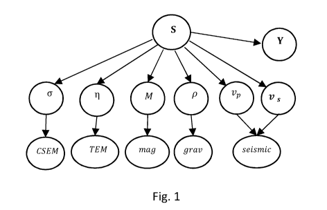
Fig. 1 is a general multi-geophysical Bayesian network for estimation of the
mineral concentration S; and
CA 03138261 2021-10-27
WO 2020/222652 PCT/N02020/050101
- 14 -
Fig. 2 is a flow chart illustrating a method of estimating a mineral content
of
a geological structure and mining for minerals.
As illustrated in Fig. 2, an embodiment of a method of estimating a mineral
content of a geological structure and mining for minerals involves six main
steps.
At step 1, geophysical data related to a geological structure is obtained over
a relatively large subsea area, which has possibly been identified as being of
potential interest, e.g. due to the presence of one or more black smokers.
As step 2, the geophysical data is processed to obtain an estimate of the
mineral content, specifically the metal sulphide concentration, of the
geological
structure. The metal sulphide concentration is estimated as a function of
horizontal
position.
At step 3, if the metal sulphide concentration estimate is above a certain
threshold (e.g. as 2.5%, 3.0%, 3.5%, 4.0% or 4.5%) at any locations in the
geological structure, then more geophysical data is obtained for those
locations.
The threshold which is used is determined based on various factors including
the
economic viability of exploring and/or mining in that location, e.g. as
discussed
above.
At step 4, the new geophysical data obtained at step 3, possibly in
combination with the geophysical data obtained at step 1, is processed to
obtain a
further (improved) estimate of the metal sulphide concentration of the
geological
structure as a function of horizontal position.
At step 5, if the further estimate of the metal sulphide concentration
(determined at step 4) is above a certain threshold (e.g. as 2.5%, 3.0%, 3.5%,
4.0%
or 4.5%) at any locations in the geological structure, then a sample of the
geological
structure at that/those locations is taken, by drilling, and analysed (e.g. in
a
laboratory) to determine which metal sulphides are present and at what
concentration(s). Again, the threshold which is used is determined based on
various factors including the economic viability of exploring and/or mining in
that
location, e.g. as discussed above.
At step 6, if a/any metal sulphide(s) of interest, e.g. copper, zinc, silver
or
gold metal sulphide(s), is (are) found to be present at sufficiently high
concentration(s), e.g. above 2.5%, 3.0%, 3.5%, 4.0% or 4.5%, then a decision
is
taken to perform a mining operation for that/those metal sulphide(s) and the
mining
operation is subsequently performed.
Each of the above steps 1-6 will now be described in more detail.
CA 03138261 2021-10-27
WO 2020/222652 PCT/N02020/050101
- 15 -
At step 1, geophysical data related to a geological structure is obtained over
a relatively large subsea area, such as up to 10,000 km2. In some embodiments,
the geophysical data collected at this step consists of only gravity,
(possibly)
magnetic and seismic data. This data can be collected using apparatus on board
a
survey vessel and there is no need, for example, to send an autonomous
underwater vehicle (AUV) down to the seabed to collect other kinds of
geophysical
data.
However, in other embodiments, one or more of TEM data, magnetic data,
CSEM data and magnetotelluric data are also or alternatively collected at this
step,
for example with EM receivers dropped from a vessel.
As step 2, the geophysical data is processed to obtain an estimate of the
mineral content, specifically the metal sulphide concentration, of the
geological
structure. Step 2 actually contains two stages: at stage (i), the geophysical
data
collected at step 1 is inverted to determine geophysical parameters; and at
stage
(ii), the determined geophysical parameters are inverted to estimate the metal
sulphide concentration of the geological structure.
This processing step is now explained in more detail with reference to Fig.
1.
Dependencies between physical quantities can conveniently be represented
by Bayesian networks. Fig. 1 shows a general multi-geophysical Bayesian
network
for estimation of a mineral (e.g. metal sulphide) concentration S from
geophysical
parameters ti M, p,
vp, vs} . As shown in Fig. 1, the geophysical parameters
ti M, p,
vp, vs} in turn depend on geophysical data, such as controlled source
electromagnetic data (CSEM), transient electromagnetic data (TEM), magnetic
data
(may), gravity data (gray), and seismic data (seismic), which can be included
in
an extended Bayesian network. In this figure, a is resistivity (or
conductivity), 11 is
the induced polarisation coefficient, M is total magnetization (including both
induced
and remnant magnetization), p is density, Vp is p-wave velocity, and vs is s-
wave
velocity.
Geochemistry parameter(s) Y may also be used to estimate the mineral
concentration S. The geochemical parameters can be obtained by making
laboratory measurements of rock samples and/or water samples. For example, the
presence or concentration of certain signature minerals from hydrothermal
alteration or gases (e.g. Helium 3He) in the sea water may be measured.
CA 03138261 2021-10-27
WO 2020/222652 PCT/N02020/050101
- 16 -
In principle, all of the variables in the Bayesian network of Fig. 1 can be
regarded as stochastic. However, here, a simplified approach is used, taking
only
S and the actual measured geophysical data and the geophysical parameters on
which they depend, as stochastic variables. The other variables are treated as
deterministic hyperparameters or as having delta-function distributions.
Thus, in the case where just gravity and seismic data are collected, the main
parameters of interest here are gravity data (gray), density (p), seismic data
(seismic), p-wave velocity (vp), s-wave velocity (vs), and metal sulphide
concentration (S).
The Bayesian network can be applied to obtain the joint distribution for a set
of parameters, incorporating the principle of conditional independence. The
joint
probability of a set of stochastic nodes {xi, xn} can be written as
ilmr imr),
(1)
where xPa, denotes the parents of xõ i.e. nodes on the level above in the
network.
Using equation (1), and marginalizing hidden variables, the posterior
distribution for metal sulphide concentration S given gravity and seismic data
can
be written as
p(S1c1) = C f p(S1m)p(micedm (2)
where C is the normalization factor, m = (m1, m2, , mn) is a vector of
geophysical
model parameters and d = (d1, d2, dk) is a vecor of different geophysical data
types, as discussed above.
The integral marginalizes the model parameters.
The geophysical model parameters mi may be density, magnetization
(induced and remnant), electric resistivity or conductivity, polarization
coefficient,
seismic P- and S-wave velocity.
The data di may be gravity data, magnetic data, electromagnetic data and
seismic data.
As explained above, in practice, the inversion is performed in two separate
steps:
(i) the (e.g. gravity and
seismic) geophysical data are inverted to
calculate the geophysical parameter(s) on which they depend (e.g.
density p, p-wave velocity vp, and s-wave velocity vs); then
CA 03138261 2021-10-27
WO 2020/222652 PCT/N02020/050101
- 17 -
(ii) the geophysical parameters are inverted to determine the
metal
sulphide concentration S.
At step (i), the geophysical parameters density p, p-wave velocity vp, and s-
wave velocity vs are computed by inversion of gravity and seismic data. Using
Bayes rule, the following is obtained
P(nld) = P(d1m) P(m) (3)
At step (ii), metal sulphide concentration S is computed by inversion of the
geophysical parameters, e.g. density p, p-wave velocity vp, and s-wave
velocity vs.
Again using Bayes rule, the following is obtained
p(S1m) = p(mIS) p(S) (4).
This involves a non-linear phenomenological relationship between the
geophysical parameters, e.g. density p, p-wave velocity vp, and s-wave
velocity vs,
and metal sulphide concentration S, which is discussed below.
Finally, the posterior distribution p(Sid) is obtained by means of equation
(2). The marginalization of S can be written (in some cases) on a convolution
form,
which allows for fast and efficient computation using the fast Fourier
transform
(FFT).
Step (i) can be performed using standard, well-known geophysical inversion
methods.
In some embodiments, step (i) is performed using a map inversion method,
e.g. a Marquardt-Levenberg type map inversion method, to determine laterally
varying geophysical parameters (density p, p-wave velocity vp, and s-wave
velocity
Vs), each averaged over a relevant depth interval.
Alternatively, step (i) can be performed using any other (e.g. 3D) inversion
method serving the same purpose.
Step (ii) uses a Bayesian inversion method involving a phenomenological
model relating the geophysical parameter(s) (e.g. density p, p-wave velocity
vp, and
s-wave velocity vs) to the metal sulphide concentration, to calculate the
metal
sulphide concentration value from the geophysical parameter(s).
In order to obtain a spatially dependent 3D metal sulphide concentration
function, the metal sulphide concentration of the geological structure is
calculated
point-wise for multiple different points/locations/volumes/spaces in the
geological
structure. As can be appreciated, the geophysical parameter(s) may vary over
the
CA 03138261 2021-10-27
WO 2020/222652 PCT/N02020/050101
- 18 -
space of the geological structure, and this may correspond to a spatially
varying
metal sulphide concentration.
Phenomenological models which can be used to relate geophysical
properties to underlying rock properties are illustrated in the charts in Fig.
3.
Charts (a) and (b) illustrates the relationship between conductivity a and
metal sulphide fraction. The logarithm of conductivity increases linearly with
conductivity.
Chart (c) illustrates the relationship between the induced polarisation (IP)
coefficient r and the metal sulphide fraction. The induced polarisation (IP)
coefficient increases with the metal sulphide fraction.
Chart (d) illustrates the relationship between the total magnetisation M
(remnant and induced magnetisation) and the metal sulphide fraction. The total
magnetisation decreases with the metal sulphide fraction.
Thus, following the above method, the metal sulphide concentration is
estimated as a function of horizontal position.
Next, at step 3, if the metal sulphide concentration estimate is above a
certain threshold such as described above at any locations in the geological
structure (e.g. forming an area or region of interest), then more geophysical
data is
obtained for those locations (e.g. at the area or region of interest).
As discussed above, in some embodiments, the geophysical data collected
at step 1 consists of only gravity and seismic data, which is collected from a
survey
vessel over an area of up to or around 10,000 km2.
If step 2 indicates that there may be areas within that area which have
sufficiently high metal sulphide concentrations to warrant further
investigation, at
step 3, more geophysical data is obtained for that (those) locations, e.g.
within the
area over which geophysical data was obtained at step 1.
In some embodiments, the geophysical data obtained at step 3 includes one
or more of TEM data, magnetic data, CSEM data and magnetotelluric data. These
kinds of data can be collected by sending an AUV down to the seabed at the
area
of interest.
The area or region of interest over which geophysical data is collected at
step 3 is smaller than the area or region over which geophysical data is
collected at
step 1. For example, the area or region of interest over which geophysical
data is
collected at step 3 could be around 50 km2.
CA 03138261 2021-10-27
WO 2020/222652 PCT/N02020/050101
- 19 -
At step 4, the new geophysical data obtained at step 3, possibly in
combination with the geophysical data obtained at step 1 (e.g. for that area
or
region of interest), is processed to obtain a further (improved) estimate of
the metal
sulphide concentration of the geological structure as a function of horizontal
position at the smaller area of interest.
The processing performed at step 4 follows the same stages (i) and (ii) as
set out above in relation to step 2, the only difference being that more
geophysical
data and parameters are included in the calculations. Thus, the equations
given
above in relation to step 2 can be suitably modified to account for the
geophysical
data and parameters which are included at step 4.
As more geophysical data and parameters are included in the processing
step to estimate the metal sulphide concentration, the better (more accurate)
the
estimate of the metal sulphide concentration becomes.
In some embodiments, steps 3 and 4 are omitted and all of the geophysical
data that is used is obtained and then processed together in steps 1 and 2.
Next, at step 5, if the further estimate of the metal sulphide concentration
(determined at step 4, or step 2 in some embodiments where steps 3 and 4 are
not
performed) is above a certain threshold such as described above at any
locations in
the geological structure, then a sample of the geological structure at
that/those
locations is taken, by drilling, and analysed (e.g. in a laboratory) to
determine which
metal sulphides are present and at what concentration(s).
At steps 2 and 4, only the total metal sulphide concentration is determined
but not the concentration of (a) particular metal sulphide(s). Some metal
sulphides
are more valuable than others so it is important to check which metal
sulphide(s)
is(are) present in the geological structure, and at what concentration(s),
before
deciding whether or not to mine for it (them).
Thus, at step 5, a sample is taken from the geological structure from an area
which has been determined to have a sufficiently high metal sulphide
concentration
to warrant further investigation. This sample is then tested in a laboratory
to
determine exactly which metal sulphides are present and at what concentration.
In some embodiments, step 5 involves determining whether any of all of
copper, zinc, silver and/or gold metal sulphide(s) are present in the
geological
structure and at what concentration.
Finally, at step 6, if a/any metal sulphide(s) of interest, e.g. copper, zinc,
silver or gold metal sulphide(s), is (are) found to be present at sufficiently
high
CA 03138261 2021-10-27
WO 2020/222652
PCT/N02020/050101
- 20 -
concentration(s), e.g. above 2.5-4%, then a decision is taken to perform a
mining
operation for that/those metal sulphide(s) and the mining operation is
subsequently
performed.
The above method can be used when prospecting for minerals (e.g. metal
sulphides), e.g. when planning and performing mineral mining operations.
In one embodiment, the calculated mineral content (e.g. metal sulphide
concentration) is used prior to mining, when deciding where to mine the mine
and/or how deep to mine the mine.
In the same or other embodiments, the calculated mineral content is used
during or after the mining of the mine, e.g. when deciding in which direction
or to
which depth to continue mining.
The mineral content estimate can be updated during mining based on new
measured geophysical data.