Note: Descriptions are shown in the official language in which they were submitted.
CA 03140363 2021-11-12
WO 2020/232082
PCT/US2020/032617
MONITORING TOOL, SYSTEM AND METHOD
FOR EARTH WORKING EQUIPMENT AND OPERATIONS
RELATED APPLICATION
[01] This application claims the benefit of priority from US. Provisional
Patent Application
No. 62/847,842, filed May 14, 2019, the entirety of which is incorporated by
reference.
FIELD OF THE DISCLOSURE
[02] The present disclosure pertains to a monitoring tool, system and
process for monitoring
earth working operations.
BACKGROUND OF THE DISCLOSURE
[03] Multiple configurations of excavating machines and buckets are known
and variations
in both exist. Figures 1A-1B illustrate two examples of earth working
equipment. Figure 1A
illustrates an excavator equipped with a boom 2, a stick 20 and a bucket 3 for
gathering
earthen material 24. Figure 1B illustrates a cable shovel equipped with a
bucket 3A with a
hinged door 10A to release earthen material 24A. Referring to Figure 2, the
bucket 3 includes
a shell 4 defining a cavity 16 for gathering material during the digging
operation. Shell 4
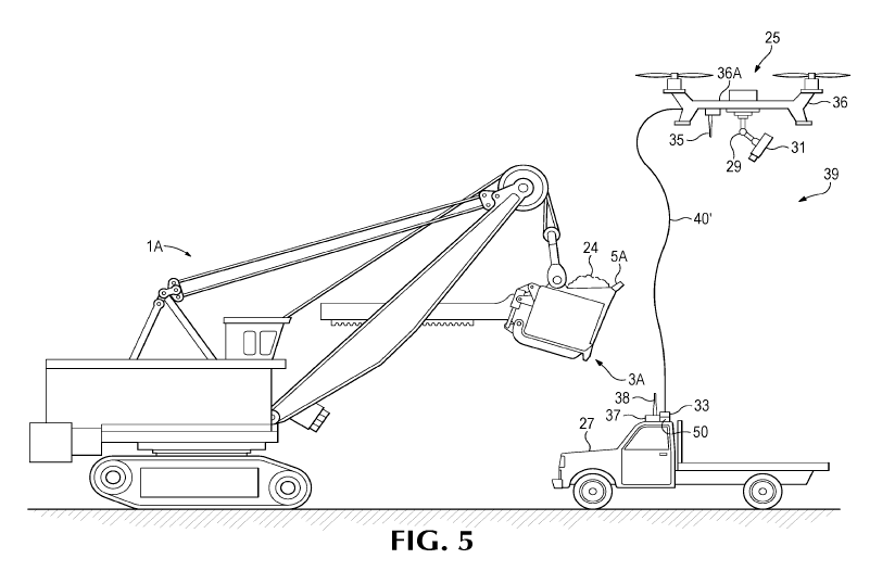
includes a rear wall 12 with supports 8 to attach the bucket 3 to earth
working equipment 1,
and a pair of opposing sidewalls 14 located to each side of rear wall 12. The
bucket 3 has a
lip 5 that defines a digging edge 34 of the bucket 3. Teeth 7 and/or shrouds 9
are often
secured to the digging edge 34 to protect the edge 34, break up the ground
ahead of the lip
5, and/or gather material into the bucket 3. Multiple teeth 7 and shrouds 9,
such as disclosed
in US Patent 9,222,243 may be attached to lip 5 of bucket 3.
[04] With reference to Figures 3-4, each tooth 7 includes an adapter 11
welded to lip 5, an
intermediate adapter 13 mounted on adapter 11, and a point (also called a tip)
15 mounted on
intermediate adapter 13. Point 15 includes a rearwardly-opening cavity 18 to
receive nose 17
of intermediate adapter 13, and a front end 19 to penetrate the ground.
Intermediate adapter
13 includes a rearwardly-opening cavity 22 to receive a nose 23 of adapter 11.
Locks 21 are
used to secure point 15 to intermediate adapter 13, and intermediate adapter
13 to adapter
11 (Figure 4). Other tooth arrangements are possible, such as disclosed in US
Patent
7,882,649.
[05] In this example, the point 15 will generally wear out and need to be
replaced a number
of times. The intermediate adapter 13 may be referred to as a base for this
wear part.
However, the intermediate adapter 13 may also be referred to as a wear part.
Likewise, while
the adapter 11 is a base for the intermediate adapter 13, adapter 11 may also
be considered
a wear part that can be replaced when worn. When such wear parts reach a
minimum
1
CA 03140363 2021-11-12
WO 2020/232082
PCT/US2020/032617
recommended wear profile (e.g., the wear member is considered fully worn), the
product is
replaced so that production does not decrease and the base, upon which the
wear part
mounts, does not experience unnecessary wear.
[06] During use, such ground-engaging products can encounter heavy loading
and highly
abrasive conditions. These conditions can cause the products to wear or become
separated
from the earth working equipment. For example, as a bucket engages the ground,
a wear part
such as a point or intermediate adapter may become separated from the digging
edge. The
operators of the earth working equipment may not always be able to see when
such products
have separated from the bucket. Continuing to operate the earth working
equipment with
missing ground-engaging products (such as points) can lead to a decrease in
production
and/or excessive wear on the lip, bucket walls or other components on the
earth working
equipment. It is also known that a lost wear part in a mining environment may
cause damage
to downstream equipment (e.g., crushers), which may, in turn, for example,
lead to
unscheduled downtime of the equipment and loss of production. If a wear part
becomes
caught in a crusher, the wear part may be ejected and cause a hazard to
workers or it may be
jammed and require an operator to dislodge the part, which at times may be a
difficult, time-
consuming and/or hazardous process. Excessive wearing of the teeth and/or
shrouds can also
result in decreased equipment efficiency and production, greater costs in fuel
consumption,
etc.
[07] There are existing systems that have been used to monitor wear parts
in an effort to
determine when a wear part needs replacement and/or has been lost with varying
degrees of
success. For example, systems sold by Motion Metrics use an optical camera
mounted on
the excavating equipment to determine the amount of wear in the wear parts and
when wear
parts are lost. Current systems for monitoring of ground-engaging products
have not,
however, consistently provided satisfactory results on account of the
environment, limited
viewing capabilities, etc.
SUMMARY OF THE DISCLOSURE
[08] The present disclosure pertains to a monitoring tool, system and/or
method for
monitoring earth working equipment, wear parts, operations and/or the earthen
material such
as found in mining and construction.
[09] In one example, a monitoring tool includes an unmanned vehicle and a
tether. The
vehicle includes an electronic device to monitor at least one characteristic
pertaining to an
earth working operation, and to transmit information pertaining to the at
least one
characteristic. The tether connects the unmanned vehicle to a home device.
[10] In another example, a monitoring tool includes a home device, an
unmanned vehicle
having an electronic device to monitor at least one characteristic pertaining
to an earth working
2
CA 03140363 2021-11-12
WO 2020/232082
PCT/US2020/032617
operation and to transmit information pertaining to the at least one
characteristic, and a tether
connecting the unmanned vehicle to the home device.
[11] In another example, a monitoring system includes at least one earth
working
equipment and a monitoring tool. The monitoring tool includes a home device,
an unmanned
vehicle having an electronic device to monitor at least one characteristic
pertaining to an earth
working operation and to transmit information pertaining to the at least one
characteristic, and
a tether connecting the unmanned vehicle to the home device.
[12] In any of the above examples, the tether can optionally provide power
and/or data
transmission. The unmanned vehicle may be remotely controlled or autonomous or
some
combination thereof. The unmanned vehicle can be an aerial and/or land
vehicle.
[13] In another example, the unmanned vehicle is connected to a home
device. The home
device may be a stand-alone device, secured to a transport vehicle, an earth
working
equipment and/or other structure, or be the vehicle, equipment or the like.
The unmanned
vehicle is connected to the home device by a tether to secure, power and/or
transmit data to
and/or from the unmanned vehicle. The home device can include a power source
to provide
power to the monitoring tool. The home device may include a transceiver to
receive and send
data to and/or from a remote device. The home device may also include a
processor to make
determinations based on the information received from the monitoring tool.
[14] The various above-noted implementations and examples are usable together
or
independently. To gain an improved understanding of the advantages and
features of the
disclosure, reference may be made to the following descriptive matter and
accompanying
figures that describe and illustrate various configurations and concepts
related to the
disclosure.
BRIEF DESCRIPTION OF THE DRAWINGS
[15] Figure 1A is a side view of an earth working machine.
[16] Figure 1B is a side view of another earth working machine.
[17] Figure 2 is a perspective view of a bucket with teeth and shrouds.
[18] Figure 3 is a perspective view of one of the teeth shown in Figure 2.
[19] Figure 4 is an exploded perspective view of one of the teeth shown in
Figure 3.
[20] Figure 5 illustrates a first example of a monitoring system in
accordance with the
present disclosure.
[21] Figure 6 illustrates a second example of a monitoring system in
accordance with the
present disclosure.
[22] Figure 7 illustrates a third example of a monitoring system in
accordance with the
present disclosure.
3
CA 03140363 2021-11-12
WO 2020/232082
PCT/US2020/032617
[23] Figure 8 illustrates a fourth example of a monitoring system in
accordance with the
present disclosure.
[24] Figure 9 is a front view of an example mobile handheld device with a
human machine
interface (HMI) to be used with a monitoring system in accordance with the
present disclosure.
[25] Figure 10 illustrates a fifth example of a monitoring system in
accordance with the
present disclosure.
DETAILED DESCRIPTION OF PREFERRED EMBODIMENTS
[26] The present disclosure pertains to a monitoring tool, system and/or
process for
monitoring at least one characteristic of an earth working operation.
[27] In one embodiment, a monitoring tool includes a tethered vehicle
having a sensor. The
tether can provide power and/or data transmission for the monitoring tool. The
tether can also
improve the safety of the monitoring tool. The monitoring tool can be used to
monitor at least
one characteristic of one or more earth working operation including, for
example, the
monitoring of earth working equipment (including its usage, performance,
components, wear
parts, etc.) and/or the earthen material associated with the earth working
operation. The
monitoring tool, system and/or process can include any or all the features,
capabilities,
embodiments and/or operations as disclosed for the monitoring tools, systems
and/or
processes in U.S. Publication No. 2016/0237640 filed February 12, 2016, which
is herein
incorporated by reference in its entirety.
[28] With reference to Figure 5, a monitoring system 39 is illustrated
according to one
example. The monitoring system 39, in this example, includes an earth working
equipment
1A in the form of a cable shovel having a ground engaging product 3A in the
form of dipper
with ground-engaging wear parts 5A in the form of teeth and shrouds, and a
monitoring tool
25. The monitoring tool 25 can monitor at least one characteristic of an earth
working
operation, examples of which can include the condition, usage and/or
performance of the earth
working equipment, its components (e.g., its boom, stick, pulleys, etc.), its
associated wear
parts (e.g., teeth, shrouds, track pads, etc.), other related equipment (e.g.,
haul trucks) and/or
the earthen material before, during and/or after it is gathered in the dipper
3A.
[29] The monitoring tool 25 may include a unmanned vehicle 36, a sensor or
electronic
device 31 supported by the unmanned vehicle, and a tether 40 connecting the
unmanned
vehicle to a home device 33. In the illustrated example, the unmanned vehicle
36 is an
unmanned aerial vehicle (UAV) 36A though land-based vehicles can also be used.
The
tethered UAV 36A may be in the form of, e.g., a drone, helicopter, blimp,
airplane, or other
aerial vehicle, and include at least one sensor 31. As one example, the
electronic device 31
may be a surface characterization device, e.g., a camera or other device that
creates, e.g., a
two- or three-dimensional representation (e.g. point cloud) or other
representation of at least
4
CA 03140363 2021-11-12
WO 2020/232082
PCT/US2020/032617
a portion of the equipment 1A, the components thereof, wear parts 5A, gathered
material,
earthen material to be excavated, associated equipment, etc. Using a tethered
UAV 36A for
monitoring equipment, usage, wear parts, etc. has certain advantages, in that,
the aerial
monitoring tool 25 can, e.g., provide unique vantage points and/or to take
readings at virtually
any point in the operation without inhibiting the operation, requiring the
equipment or other
monitored item(s) to be in a particular location and/or orientation, and/or
endangering
personnel. The unmanned vehicle 36 permits a sensor 31 to closely approach the
area(s) of
interest (such as components of the equipment, wear parts secured to the
equipment, an
earthen bank to be excavated, etc.) for secure and reliable gathering of
information. The
tethered UAV 36A is connected to the home device 33 via tether 40.
[30] The use of a tether 40 can improve safety of the monitoring operation
such that the
UAV 36A can only fly in a limited radius of space from the home device 33 as
defined by the
length of the tether. For example, the tether 40 limits the potential fly
space of the UAV 36A to
provide a level of safety against the UAV 36A flying into unintended space
(e.g., into the earth
working equipment, other sectors of the mine, etc.). The use of a tether 40
secured to the
unmanned vehicle can also reduce the risk of theft. The tether 40 can be
composed of a wide
variety of materials so long as they provide sufficient strength, flexibility
and/or durability for
the anticipated operations. The tether is preferably lightweight, flexible,
and thin to minimize
the drag and/or interference that can result on account of weather conditions
(e.g., high winds)
reacting on the tether. This allows the tethered unmanned vehicle 36 to
function in more hostile
environments. The tether 40 may have a winch system to easily extract and
retract the
unmanned vehicle 36. The winch system can be biased to automatically eliminate
unneeded
lengths of the tether from being exposed and catching or becoming tangled on
nearby things.
The winch system can also improve safety by providing an adjustable tether
length to suit
different needs and, thereby an adjustable (e.g., reduced) flying space from
the home device
33; this can reduce the risk of potential user error and crashes because the
tethered drone
has a limited spatial radius or area it can roam.
[31] In another example, the tether 40 may include a conductive wire to
power the
unmanned vehicle 36, sensor and/or other components on the vehicle. The tether
40 may
pass power to the tethered unmanned vehicle 36 from a power source or supply
50 associated
with the home device 33 to extend the time the UAV 36A can be airborne and/or
increase the
number, kind or capabilities of the sensor(s) or other components on the
unmanned vehicle.
The power supply 50 could, e.g., include one or more battery, generator, or
other electrical
power source and/or a connection from the home device 33 to another power
source (e.g.,
the earth working equipment, transport vehicle, electrical outlet, etc.). As
examples only, the
power supply 50 may, e.g., convert alternating current (AC) electricity into
direct current (DC)
electricity, and the tethered unmanned vehicle 36 may include DC-DC converters
to supply
CA 03140363 2021-11-12
WO 2020/232082
PCT/US2020/032617
lower voltage power to the sensor 31 and other components. The power through
the tether
40, in certain embodiments, can allow for virtually unlimited flight or work
times rather than
being limited by the battery capacity of the drone. The enhanced power can
also be useful in
running one or more sensors carried by the tethered unmanned vehicle 36 and/or
powering
other components such as processors, lights, etc. The sensor 31 and/or
tethered UAV 36A
could include battery power instead of or in addition to power through the
tether, which can,
e.g., allow for a fail-safe operation, operation when the tether does not
transmit power and/or
if a power supply is not available at a particular site.
[32] In another example, the tether 40 may include a wire, optical fiber or
other
communication transmission conduit to allow the tethered unmanned vehicle 36
to pass
signals to and/or from the home device 33. Such signals may include such
things as sensor
data, software, and/or operating instructions for the tethered unmanned
vehicle 36. The tether
40 may exist as a standalone network (e.g. just the home device 33 and the
tethered
unmanned vehicle 36) or may be a part of a larger network (e.g. network 142).
The tether 40
may optionally be encrypted for use with the home device 33 to allow for a
more secure
transfer of information. In embodiments where data is communicated through the
tether 40,
the data transmission can be faster, more reliable and/or better secured
against unauthorized
reception as compared to a wireless signal. The unmanned vehicle 36 may
optionally include
a wireless transmitter 35 as a supplement or backup to transmitting through
the tether 40 or
when used with a tether lacking data transmission and/or when a receiver for
the tether is not
available on site.
[33] The home device 33 can be carried by and/or secured to, or be one of, a
service truck
or other vehicle 27 (Figure 5), earth working equipment 1 (Figure 6), or other
structure,
equipment or device on the worksite. The home device 33 can be a discrete
device that is
carried by or connected (or connectable) to a vehicle, equipment or other
structure, and/or
which could be a standalone device that can be placed at a suitable location
on the worksite.
For example, the home device 33, tether 40, and unmanned vehicle 36 could be a
discrete
monitoring tool 25 that is carried by a service truck to one or more locations
on a mine site or
other worksite. As another example, a monitoring tool 25 could be transported
by a service
truck and left at a particular location at a mine site or other worksite. As
another example, one
or more monitoring tool 25 could be coupled to and/or carried by equipment at
a worksite such
as excavating equipment, haul trucks, crushers and/or other mineral processing
equipment,
conveying equipment, chutes, etc. In another example, the unmanned vehicle 36
could be
flown to the location for monitoring (e.g., earth working equipment) without
the need for a
separate transport vehicle 27 and there connected to a tether 40 secured to a
home device
33; the unmanned vehicle 36 could in some cases carry the tether 40 with it
for securing to a
home device 33. As another example, the home device 33 could be an
autonomously or
6
CA 03140363 2021-11-12
WO 2020/232082
PCT/US2020/032617
remotely controlled vehicle. The home device 33 operates as a base for the
unmanned vehicle
36 and is optionally capable of acting as a power source,
transmitter/receiver, base/hub,
anchor, landing spot, garage, vehicle, connector, etc. The home device 33
could also include
a processor 199 for processing data received from the tethered unmanned
vehicle 36 by
means of the tether 40 or other means.
[34] There are a number of off-the-shelf UAVs that could be used or modified
for use as
the unmanned vehicle of the present disclosure; the unmanned vehicle may also
be custom
built. For example, the tethered UAV 36A may require an operator to maneuver
the tethered
UAV 36A by means of, e.g., a joystick. The UAV 36A may be autonomous or a
combination
of control by operator and by programming for flight, takeoff, and/or landing.
In addition, the
tethered UAV 36A may automatically hover in place above the earth working
equipment 1A;
the hover location could be determined by an operator, automatically through
use of beacon
37A, sensor 31 and/or other means, and/or by other suitable operations. In
another example,
the monitoring tool may by such things as programming, sensors, beacons, etc.
can maneuver
to continuously, periodically, cyclically and/or in other ways monitor at
least one characteristic
of an earth working operation such as monitoring usage, condition and/or
performance of an
earth working equipment, its components, wear parts, etc. and/or the earthen
material. In
another example, the tethered UAV 36A may not require an operator for takeoff
or landing and
may fly a set pattern before landing. The tethered UAV 36A may coordinate
and/or be
controlled so as not to land in the same place or location as where the
tethered UAV 36A took
off.
[35] Referring to Figure 7, the monitoring tool 25B may include a ground-
based unmanned
vehicle 36B, such as a tethered ground-based robot for maneuvering at least
one electronic
device or sensor 31B. The benefits discussed herein regarding aerial unmanned
vehicles
(e.g., concerning safety, power supply and communication transmission) would
also apply to
ground-based unmanned vehicles 36B. Also, the variations discussed above for
aerial
unmanned vehicles would apply to ground-based unmanned vehicles with the
understanding
that references to flying space and the like would be replaced by driving
space and the like. In
the illustrated example, a transport vehicle 27 carries the monitoring tool
25B for initial
transportation to a desired location, at which point it can, optionally, be
unloaded for operation
(as in Fig. 7). It could alternatively stay on the transport vehicle for
certain operations. In the
illustrated embodiment, the ground-based robot 36B is connected to a home
device 33
secured to transport vehicle 27. The ground-based unmanned vehicle 36B is
capable of
maneuvering an electronic device 31B so that it can monitor at least one
characteristic of an
earth working operation, e.g., the products 5A on bucket 3A. Alternatively,
the ground-based
unmanned vehicle 36B may be able to transport itself without a transport
vehicle 27. The
ground-based unmanned vehicle could include many variations such as different
mobile
7
CA 03140363 2021-11-12
WO 2020/232082
PCT/US2020/032617
arrangements (e.g., wheels, tracks, etc.), various sizes to suit the need(s)
(e.g., small enough
to run on existing equipment, large enough to view certain equipment and/or
parts, etc.), being
self-powered or powered by other vehicles or equipment, include one or more
sensors,
transmitters, processors, etc. As with aerial monitoring tools, the tether 40B
can provide a
power source and/or transmission of communications to the unmanned vehicle
36B.
[36] With reference to Figure 8, a monitoring system 139 is illustrated
according to one
example of the disclosure. The system 139 may include an earth working
equipment 101B
having a ground engaging product 103B, a communication network 142, a
monitoring tool 125,
a transport vehicle 127, a processor 199, a database 194, and/or a handheld
device 128; other
alternatives and/or variations are possible. The earth working equipment 1018
includes a
bucket 103B having a lip 105B and carrying a load 124B. Teeth and/or other
ground-engaging
tools (GET) are secured to the lip; a tip 115B is illustrated in Figure 8 as
an example wear
part. The tip 11513 may optionally include a sensor 138 and antenna 135 such
as disclosed
in US 10,011,974, which is incorporated herein by reference in its entirety.
The bucket 103B,
equipment 10113, GET 115B, transport vehicle 127 and/or unmanned vehicle 136
may each
optionally include an antenna 135, a beacon 137A-D, and/or some combination
for
communicating information, providing location information, etc. As one
example, the beacons
could be used by the monitoring tool 25 to identify the location, position
and/or orientation of
equipment and the like for traveling to and/or positioning the unmanned
vehicle 136 and/or
sensor 131 for monitoring, and/or as a system for avoiding inadvertent crashes
with existing
(whether stationary or moving) equipment and the like. As one example, the
home device 33
could also contain a sensor package independent of that on the unmanned
vehicle 36. If the
heading (compass), position, or directional acceleration of the host equipment
is known to the
unmanned vehicle 36 via the home device 33 mounted on it, movement of the
unmanned
vehicle 26 or the "aim" of its onboard sensor package can be coordinated with
that of the host
equipment.
[37] The earth working equipment 10113, the transport vehicle 127, the
monitoring tool 125,
the ground engaging products 11513 (e.g. bucket and wear members), the
processor, and/or
the handheld device 128 (or other HMI) may each be in communication through
the
communication network 142 or a standalone network between the various devices.
As
examples, the communication network 142 could include intranets, internets,
the Internet, local
area networks, wide area networks (WAN), mining site network, wireless
networks (e.g. WAP),
secured custom connection, wired networks, virtual networks, software defined
networks, data
center buses and backplanes, or any other type of network, combination of
network, or
variation thereof. Communication network 142 is representative of any network
or collection
of networks (physical or virtual) and may include various elements, such as
switches, routers,
fiber, wiring, wireless, and cabling to connect the various elements of the
system 139.
8
CA 03140363 2021-11-12
WO 2020/232082
PCT/US2020/032617
Communication between system 139 components and other computing systems, may
occur
over a communication network 142, tether 140, or other networks in accordance
with various
communication protocols, combinations of protocols, or variations thereof. It
should be
appreciated that the network 142 is merely exemplary of a number of possible
configurations
according to embodiments of the present technology. In other examples, the
various
components of system 139 may be co-located or may be distributed
geographically.
[38] The monitoring system 139 may include a processor 199 (with, e.g., non-
transient
memory 200, etc.) having computer instructions, programs, software, firmware,
and the like
written thereon; all such devices will be referred to herein as processors. In
the illustrated
example (Fig. 8), the processor 199 is remote from the monitoring tool 125
(e.g., in an office
or other remote location). Nevertheless, one or more processor can be provided
with the
monitoring tool 125 (unmanned vehicle 136 and/or home device 133), the earth
working
equipment 101B, handheld device(s) 128, devices 137A-D, and/or other remote
locations. The
processor 199 may be provided with data from the one or more sensor 131, other
sensors
(such as in the GET), a handheld device 128, cloud database 194, other data
sources, and/or
other remote devices, etc. to provide information and analysis. The term
processor 199 as
used herein could include one or more processors for the system which are
operated
separately and/or concurrently. In one implementation, the processor 199 may
optionally
include the Engine Controller unit (ECU) of the earth working equipment 101B.
The ECU 199
may provide or receive information from the processor 199 and/or directly to
or from sensor(s)
131. The ECU 199 may provide data pertaining to, but not limited to, engine
torque, fuel
consumption, atmospheric temperature, engine temperature and the like. The ECU
199 data
may be coupled with sensor data, and/or data from other sources, and processed
by the
processor 199 to provide various outputs. In one example, the processor 199
may simply
facilitate communication between the monitoring tool 125 and various system
components,
through the network 142 and/or tether 140 by means of the communication device
135. Each
of the system components may include individual processors 199 or a single
processor 199
(distributed or otherwise) may control each of the various components of the
system 139. In
one example, the various components of the computer system 198 may be co-
located,
virtually, and/or may be distributed geographically. As those skilled in the
art will appreciate,
other exemplary computer systems 198 according to embodiments of the
technology may
include different components than those illustrated and described herein.
[39] The monitoring tool 125 and/or monitoring system 139 could be used to
monitor
various characteristics of an earth working operation involving, for example,
equipment,
products, usage, performance, earthen material, etc. As examples, the
monitoring tool 125
may monitor (and/or a processor(s) make determinations regarding) the
condition, usage,
and/or performance of earth working equipment such as excavators, haul trucks,
dredging
9
CA 03140363 2021-11-12
WO 2020/232082
PCT/US2020/032617
equipment, conveying equipment, chutes, crushers, mineral processing
equipment, etc.
and/or portions of the equipment such as lips, buckets, mold boards, sticks,
booms, chassis,
motive systems, truck trays, hoppers, and other components. The monitoring
tool 125 and/or
system 139 may, for example, monitor (and/or make determinations regarding)
the presence,
condition, usage and/or presence of wear parts associated with earth working
equipment such
as points 15, intermediate adapters 13, adapters 11, noses 15 of a cast lip,
shrouds 9, runners,
picks, track shoes, blades, corner shoes, hammers, and/or other wear parts.
The monitoring
tool 125 and/or system 139 may, for example, monitor (and/or make
determinations regarding)
usage and/or performance of the equipment such as the loads within the bucket,
truck tray,
hopper, etc., the speed of certain operations such as digging cycles, loading
times, conveying
times, throughput of mineral processing equipment, etc., the number of digging
cycles, etc.
The monitoring tool 125 and/or system 139 may, for example, monitor (and/or
make
determinations regarding) the earthen material such as ore concentration,
fragmentation, bank
angles, digging paths, etc. before, during and/or after being gathered,
processed, etc. by the
earth working equipment. The monitoring tool and/or system may also, for
example, monitor
other characteristics of an earth working operation such as part
identification, operational
limits, equipment faults, equipment proximity violations, locate system
sensors, reading
gauges and other operations within a mine site or other worksite where safety,
efficacy and/or
efficiency can be improved through the use of a tethered unmanned vehicle with
a sensor.
[40] In another example, a monitoring tool 125 can be used to generate data
usable to map
a mine site or other earth working site to estimate characteristics of the
ground-engaging
products on earth working equipment used at the site. For example, the
gathered data could
be used to generate contour-style mapping of wear rates for ground-engaging
products to
better determine such things as product replacement schedules, costs, etc. In
one example,
the data gathered by monitoring tool 125 could be combined with other data
such as mine
geology, GPS data, fragmentation, etc. to make such determinations. The data
could be used
to map other characteristics or process the site data in ways other than
mapping to generate
similar information. As other examples, the system can be used to determine
such things as
timetables for excavating certain material, replacement schedules for
products, performance
of an operator, etc.
[41] The monitoring tool 125 and/or monitoring system 139 can monitor
and/or determine
one or more characteristics that can include information related to earth
working equipment
(including components, wear parts, etc.), operational limits, locating system
sensors, usage,
performance, condition and the like. Information related to operational limits
may include such
things as overfilling equipment, overstressing equipment, etc.
Information related to
equipment faults may include predetermined values set for maximum wear (e.g.
wear profiles
for specific ground engaging products). Information related to locating system
sensors may
CA 03140363 2021-11-12
WO 2020/232082
PCT/US2020/032617
include locating system sensors, such as beacons, wear sensors, blast
monitoring sensors,
road condition sensors, material monitoring sensors, flow monitoring sensors,
fill sensors,
location sensors, and the like. Information related to part identification can
include such things
as product type, product number, customer number, brand name, trademark, bill
of material,
maintenance instructions, use instructions, etc. Information related to usage
can include such
things as the type of earth working equipment associated with the product,
number of digging
cycles, average time of digging cycles, location of the product on the
equipment, etc.
Information related to condition of the product can include such things as
wear, damage,
temperature, pressure, etc. Information related to performance can include
such things as the
rate of digging, tons moved per each increment of wear, fill rates, throughput
over a period of
time, etc. As examples, throughput could include such things as how much
material is
gathered by a bucket over a period time, how much material is loaded into a
haul truck body
overtime (which could optionally include measuring the loss of material in
transfer), how much
material is passed through a crusher or other mineral processing equipment
over a period of
time, how much material is passed through a chute or on a conveyer over time,
and the like.
As another example, the tethered UAV may spot a first piece of earth moving
equipment in
preparation for an operation with a second piece of earth moving equipment.
For example, a
haulage truck in preparation for loading by shovel. Information relating to
performance, such
as a time for preparation for loading may be measured. This information could
also be used
to coordinate the tethered UAV 136A into a specific position for better
viewing. Using a
monitoring tool 125 and especially an airborne unmanned vehicle 136 such as a
tethered UAV
136A can be advantageous by permitting a coordinated and efficient monitoring
of products
on more than one earth working equipment, such as concurrently monitoring,
e.g.,
characteristics such as the earthen bank, the condition and/or loading of a
bucket, the
presence and/or condition of wear parts on the bucket, the loading and/or
condition of a truck
body, etc.
[42] The
monitoring tool 125 can include a wide variety of sensors. As one example, the
electronic device 131 may generate a two or three-dimensional point cloud
representing an
outer surface of at least part of a product being monitored. However, various
other electronic
devices (e.g., cameras, LiDAR, etc.) could be used, and various other ways to
assess the
equipment and/or products (e.g., optical recognition) could be used. For
example, the three-
dimensional representation may be generated from more than one two-dimensional
optical
image captured by a camera 131. Examples of numerous photogrammetry devices,
digital
cameras, and/or digital single lens reflex (DSLR) cameras could be used to
photogrammetrically generate a three dimensional or other representations of
the monitored
product, load, etc. The sensor may operate continuously, at set times or event-
based (e.g.,
upon receiving a trigger or issuance of the alert). The information gathered
by monitoring tool
11
CA 03140363 2021-11-12
WO 2020/232082
PCT/US2020/032617
125 can be provided to the home device 133 and/or a remote device, for
processing or use,
continuously, periodically, on demand, or in batches. Irrespective of the
delivery mode, the
system can be operated to provide historical and/or real-time data and/or
assessment.
[43] The monitoring tool 125 can include multiple sensors. In one example,
monitoring tool
125 may include multiple surface characterization devices 131 that collect
different kinds of
information. As an example, the monitoring tool could collect data from a
sensor(s) using
infrared, visible and/or ultraviolet wavelengths. The collected information
can be integrated
together to be compared to information stored in a database 194. The
monitoring tool 125
could, e.g., collect hyperspectral images that are used to characterize the
material of, e.g., the
earthen material. Hyperspectral sensors could be such as disclosed in Korean
Publication
KR101806488, incorporated herein by reference. The sensor(s) could generate X-
rays or
polarized light that is reflected off collected ore and collected by the
sensor on the unmanned
vehicle.
[44] The sensor 131 and/or processor 199 may be configured to generate
information on a
Human Machine Interface (HMI) 171 (Figure 9) for use by an equipment operator,
manager,
auditor, contractor, vendor and/or other person. The HMI 171 may, for example,
be a
handheld device 128 or other monitor. The handheld device may be, for example,
a computer,
a phone, a tablet, or other small device that can be held and/or carried by an
operator 2. The
HMI could be in, e.g., the cab of the earth working equipment, a service
vehicle, a station, an
office, etc. The handheld device 128 or other HMI could include a processor
199 that could
combine data from the monitoring tool 125, cloud database 194, other data
sources, other
remote device, etc. to provide information and analysis. An operator may
physically hold the
handheld device 128 as the monitoring tool 125 monitors the product (Figure
8). The HMI 171
could alternatively be mounted on a stationary or adjustable support.
Referring to Figure 9,
the HMI 171 may be a wireless or wired device, may be integrated with a
display system in
the excavating equipment, and/or may be located in a remote location.
[45] The HMI 171 may include information pertaining to what is being
monitored. In the
example shown in Fig. 9, the HMI includes a visual alert 100, navigation
controls 112 for the
unmanned vehicle 136, sensor controls 110, a digging path optimization
interface 116, etc.
(Fig. 9). The HMI 171 may be configured to provide a graphical display 173 of
the current
status of the product 176. For example, a display 173 may be configured to
display, e.g., a
profile of the monitored product 176, and/or image captured by the sensor 131
(e.g. camera).
The image may include a live video feed. The display 173 may be configured to
display both
still images and/or video images. The profile 179, or image may be captured
from a vantage
point determined relative to the product not primarily dependent of the
operator manipulation
of the excavating machine controls. The display 173 may also display a
graphical
representation 185 indicative of, for example, a level of wear. The graphical
representation
12
CA 03140363 2021-11-12
WO 2020/232082
PCT/US2020/032617
may be or include text and/or a numeric value and/or a condition, e.g. "broken
tooth", and like.
In this way an operator, or other worker at or associated with the worksite,
may be made aware
of a potential problem, or characteristic of the product via the alert 100 and
may be able to
confirm, or discount the condition, and/or provide a value judgement as to the
severity of the
condition. In this way, unnecessary downtime may be reduced. In another
example, the HMI
171 may be designed to display a history chart 185 so that an operator can
determine when
an alert happened so that an operator can take the necessary actions if a
product is lost. While
specific examples are shown in Fig. 9, they are meant only as examples and not
to be limiting.
[46] The monitoring tool 125 may include a maneuvering device 129 (e.g., an
articulated,
controlled arm, driven universal joint, etc.) for maneuvering at least one
electronic device or
sensor 131. The maneuvering arm 129 may be securely connected to the unmanned
vehicle
36 at one end 45 and to the sensor 131 at the opposed end 146. In certain
examples, the
maneuvering device 129 is mounted, so that it can obtain a better view (e.g.,
a clear line of
sight) to monitor the products. The processor 199 may include instructions to
control the
orientation of the maneuvering device 129. Maneuvering device 129 could, e.g.,
be a
controlled, articulated arm, swivel or other maneuvering implement.
[47] The monitoring tool 125 and/or separate processor 199 may include
instructions to
control an electronic device or sensor 131. The sensor 131 is physically
coupled with, and/or
installed on the unmanned vehicle 136 of the monitoring tool 125 and may be
configured to
monitor at least one characteristic of an earth working operation, which in
one example
includes the monitoring of a ground-engaging product. The sensor 131 can
optionally work in
conjunction with one or more other sensor separate from the unmanned vehicle.
A separate
sensor can optionally be positioned on the earth working equipment, service
vehicle, etc. The
sensor 31 on the tethered unmanned vehicle 136 can be a passive or active
sensor that
collects data.
[48] Figure 10 illustrates another example of a system 639, which in this
involves monitoring
at least one characteristic of an earth working operation including the
loading of a truck tray
603 of a haul truck 601. Similar reference numbers are used in as used in
Figure 1 as the
previous figures to refer to the same or similar features, but in Figure 11,
the "600 series" is
used (e.g., if a feature with reference number ")(X" is used in Figures 1A,
1B, and 5-6, the
same or similar feature may be shown in Figure 11 by reference number "6XX").
The system
639 includes a haul truck 601 having a truck tray 603, a communication network
640, and a
monitoring tool 625. The truck tray 603 may be empty or carrying a load 624
(shown in
phantom). The truck tray 603 may further include runners and other wear parts.
[49] In one example, a monitoring tool 625 can provide data for a real-time
assessment of
characteristics of an earth working operation. The electronic device 631 may
generate a two
(2D) or three-dimensional (30) point cloud representing a load. In one
alternative, the
13
CA 03140363 2021-11-12
WO 2020/232082
PCT/US2020/032617
monitoring tool 625 may monitor the load 624 within the truck 601 (e.g., on a
truck bed 603)
without interrupting the operation of the loading truck 601. Monitoring the
load 624 of the truck
601 allows the operators of the earth working equipment to know, e.g., when
they have
reached a full, evenly distributed load. Overloading truck 601 can lead to
premature wear
and/or damage and underloading can lead to sub-optimal operation. Monitoring
tool 625 could,
for example, include concurrent monitoring of the excavating equipment 603,
the haul truck
601, the earthen material 624, etc.
[50] The monitoring tool and/or system may use programmable logic to determine
the
amount of earthen material within the earth working equipment based on, e.g.,
a two or three-
dimensional profile of the load 624. The monitoring tool and/or system may
also determine
an estimated weight of the load 624 within the truck 601 based on volume
(determined, e.g.,
from the profile), the degree of fragmentation of the material (e.g. through
excavation or
through crushing), and/or the ore concentration. The monitoring tool 625 may
also verify the
estimated weight of the load 624 by comparing the estimated weight to the
stated weight from
a load monitoring unit installed on the earth working equipment.
14