Note: Descriptions are shown in the official language in which they were submitted.
CA 03142063 2021-11-26
Description
WALL CONTINUOUS MINING AND CONTINUOUS FILLING WATER-PRESERVED
COAL MINING METHOD, AND WATER RESOURCE MIGRATION MONITORING AND
WATER DISASTER EARLY WARNING METHOD
Technical Field
The present invention relates to a coal mining method, in particular to a wall
continuous mining and
continuous filling water-preserved coal mining method, and water resource
migration monitoring and
water disaster early warning method, and belongs to the technical field of
coal mining.
Background Art
The northwest China region has abundant shallow coal seams, and is an
important energy base in
China. However, it is located in an arid or semi-arid continental climate
zone, where the water
resources are in short and the ecosystem is fragile, with an ecological crisis
further aggravated by
large-scale coal mining activities. The coordination between coal mining and
ecological environment
protection is always one of the major problems to be solved urgently in coal
mining in the northwest
China region. Therefore, it is of great significance to take certain technical
measures to protect the
aquifer structures in the process of coal mining to maintain the balance of
the ecological system.
Since the idea and method of "water-preserved coal mining" was put forward in
1990s, a
technological system of water-preserved mining aiming at protecting the
ecological water level has
been preliminarily formed through the development in almost 30 years. The
researches have proved
that cut and fill mining is one of the effective ways to realize water-
preserved mining in shallow coal
seams. However, there are factors that limit the wide and large-scale
application of traditional cut and
fill mining techniques, mainly including the difficulties in coordination
between coal mining and
backfilling, increased cost caused by low backfilling efficiency and low
utilization ratio of backfilling
masses, and poor adaptability of the simple coal mining method to the complex
and varying field
environments, etc.. In order to reduce the limitation of the existing cut and
fill mining method, a
water-preserved mining method in the way of "backfilling while mining" has
been proposed in recent
years, which can overcome the difficulties in the coordination between coal
mining and backfilling
successfully. However, the entire roadway mining while backfilling method not
only results in waste
of the backfilling materials but also increases the backfilling cost, and
decreases the coal mining
efficiency to a certain extent. Consequently, it is difficult to apply the
method widely.
Contents of the Invention
In order to overcome the drawbacks in the prior art, the present invention
provides a wall continuous
mining and continuous filling water-preserved coal mining method, and water
resource migration
monitoring and water disaster early warning method, which ensures continuous,
stable and efficient
coal mining at the working face, reduces the backfilling cost, improves the
utilization ratio of
backfilling materials and the coal mining efficiency, can comprehensively
monitor the loss of water
resources in the mining area and water disasters prone to occur in the stope
incurred by coal mining
Date recue / Date received 2021-11-26
CA 03142063 2021-11-26
and provide warning, and carry out evaluation rationally, and has wide
applicability.
In order to solve the above problems, the present invention provides a wall
continuous mining and
continuous filling water-preserved coal mining method, which comprises the
following steps:
step 1: dividing the working face into several groups of "mining-backfilling"
mining blocks and
"mining-reserving" mining blocks arranged alternately along the orientation of
the working face;
mining the "mining-backfilling" mining blocks and the "mining-reserving"
mining blocks in the form
of wide-roadway heading, reserving no coal pillar between the mined roadways
and backfilling the
mined roadways in the "mining-backfilling" mining blocks, while reserving
narrow coal pillars
between the mined roadways and leaving the mined roadways unfilled in the
"mining-reserving"
mining blocks;
step 2: arranging an auxiliary haulage roadway and a main haulage roadway
along the orientation of
the working face, and excavating through-cuts in the edge of the working face
in the slope direction
to form ventilation loops, wherein each cycle of wide-roadway excavation along
the entire working
face is equivalent to a normal cutting feed of a long-wall face coal cutter,
and the width of the wide
roadway is equal to the depth of a cutting feed of the coal cutter, i.e., the
mining area is arranged in
the form of long-wall face stoping;
step 3: dividing each "mining-backfilling" mining block into m mining sections
in the advancing
direction of the working face, with the mining section at the edge of the
mining block and near a
through-cut denoted as a first mining section, and the rest mining sections
sorted orderly; dividing n
mining wide roadways in each mining section in a direction perpendicular or
inclined to the
orientation of the working face, with the mining wide roadway at the edge of
the mining section and
near the through-cut denoted as a first mining wide roadway, and the rest
mining wide roadways
sorted orderly;
step 4: in each "mining-backfilling" mining block, firstly, mining the first
mining wide roadway Ril
in the first mining section, and then mining the first mining wide roadway R21
in the second mining
section, and so on, till the first mining wide roadway Rmi in the mil' mining
section is mined; in each
mining section, skipping a wide roadway from the first wide roadway and mining
the third wide
roadway R13 in the first mining section, then mining the third mining wide
roadway R23 in the second
mining section sequentially, and so on, till the third mining wide roadway Rm3
in the /nth mining
section is mined; carrying out mining in the above mining sequence after all
odd-numbered wide
roadways in the mining section are mined, till all odd-numbered wide roadways
in each mining
section are mined;
then, mining the second mining wide roadway R12 in the first mining section
first, then mining the
second mining wide roadway R22 in the second mining section, and so on, till
the second mining wide
roadway Rm2 in the mil' mining section is mined; in each mining section,
skipping a wide roadway
from the first wide roadway and mining the fourth wide roadway Ri4 in the
first mining section, and
then mining the fourth mining wide roadway R24 in the second mining section
sequentially, and so
on, till the fourth mining wide roadway Rm4 in the mil' mining section is
mined; mining in the above
mining sequence, till all even-numbered mining wide roadways in the mining
section are mined;
step 5: backfilling the first mining wide roadway in the first mining section
immediately after it is
mined, and mining the third mining wide roadway in the first mining section at
the same time, thus
2
Date recue / Date received 2021-11-26
CA 03142063 2021-11-26
forming a simultaneous operation mode at the mining face and the backfilling
face in the mining
block, till all odd-numbered mining wide roadways in all mining sections are
mined and backfilled;
wherein in the case that n is an odd number, the even-numbered mining wide
roadways in all mining
sections are mined only but not backfilled; in the case that n is an even
number, the mining wide
roadway at the boundary of the "mining-backfilling" mining block is backfilled
after it is mined,
while the even-numbered mining wide roadways in all remaining mining sections
are mined only but
not backfilled;
step 6: dividing each "mining-reserving" mining block into several mining wide
roadways II and
narrow coal pillars arranged alternately, sorting the mining wide roadways II
orderly in the advancing
direction of the working face and mining them sequentially; specifically,
mining the mining wide
roadways in each mining block without backfilling, i.e., only mining faces II
exist in the mining block,
till all mining wide roadways II in the mining block are mined;
step 7: according to the mining sequence and principle for the mining wide
roadways and mining
wide roadways II specified in the step 3 to step 6, arranging a plurality of
mining faces respectively
in the "mining-backfilling" mining blocks and the "mining-reserving" mining
blocks, and mining the
mining wide roadways simultaneously and backfilling the mining wide roadways
that meet the
criteria specified in the step 5; according to the mining sequence and
principle for the mining wide
roadways and the mining wide roadways II specified in the step 3 to step 6,
arranging a plurality of
"mining-backfilling" mining blocks and "mining-reserving" mining blocks in the
working face and
mining them simultaneously, thus forming multi-heading parallel operation,
till the entire working
face is mined.
The "mining-backfilling" mining blocks are used as the main mining blocks, and
the branch roadways
are mined and backfilled by means of wide roadway driving; the "mining-
reserving" mining blocks
are also mined by means of wide roadway driving, but narrow coal pillars are
reserved there to make
coordination between the coal mining ratio and the backfilling ratio. By
controlling the mining
parameters and backfilling parameters during wide roadway driving in the
"mining-backfilling"
mining blocks and the "mining-reserving" mining blocks, the development of the
water-conducting
fissures in the overlaying strata can be adjusted and controlled effectively,
reasonably and timely, so
as to realize water-preserved coal mining and optimize the overall coal mining
benefits.
Preferably, in the step 1, the mining blocks are main mining blocks, and the
ratio of advancing length
of the "mining-backfilling" mining blocks to the advancing length of the
"mining-reserving" mining
blocks is at least 2:1.
Preferably, when a plurality of working faces are arranged in the "mining-
backfilling" mining block
and mined and backfilled simultaneously in the step 7, the number of
backfilling faces should not be
greater than the number of mining faces, and the backfilling face and the
mining face should be
separated from each other at least by a mining wide roadway or a roadway that
has been backfilled
and reached specified bearing strength.
Furthermore, in the process of wide roadway mining in the "mining-backfilling"
mining blocks, the
backfilling ratio of the mining wide roadways in the "mining-backfilling"
mining blocks is controlled
by calculating whether the development of water-conducting fissures in the
overlaying strata
penetrate the confining stratum; the relationship between the development
height of the water-
3
Date recue / Date received 2021-11-26
CA 03142063 2021-11-26
conducting fissures in the overlaying strata and the backfilling ratio is be
expressed as follows:
-12
Hu2p (1-0+1j+ =0
where, Hui, is the development height of the water-conducting fissures in the
overlaying strata, in unit
of m; A/ is the thickness of the coal seam, in unit of m; ri is the
backfilling ratio, i.e., the ratio of the
volume of the fully compacted filling body in the mining wide roadway to the
volume of the mined
coal; 2 is an influencing coefficient of the development of water-conducting
fissures in the overlying
strata, which is affected by factors such as geological conditions, coal
mining technology and
backfilling technology.
Based on the theory of equivalent permeability coefficient of the rock strata
in the permeation fluid
mechanics, the equivalent permeability coefficient of each rock stratum above
the water-conducting
fracture zone of the overlying strata is calculated respectively, and the
permeability change of the
equivalent confining bed of the overlying strata in the process of wide
roadway driving and
backfilling is analyzed to judge whether the overlying strata can meet the
requirements of water-
preserved coal mining.
Furthermore, in the process of wide roadway driving in the "mining-reserving"
blocks, the number of
gobs of mining wide roadway is controlled by calculating the ultimate strength
of the narrow coal
pillars; the number n of gobs of mining wide roadway that can prevent
instability of the narrow coal
pillars in the "mining-reserving" blocks should meet the following criterion:
[a] Sp f
n __________________________________________
rkfF(Sp+Sc.)2
where, [a] is the compressive strength of the coal pillars, in unit of MPa; F
is the safety coefficient of
the coal pillars; Sp is the width of the narrow coal pillars, in unit of m; S,
is the width of the mining
wide roadways, in unit of m;f is the Protodyakonov coefficient; y is the
average bulk density of rock,
in unit of N/m3; kf is the correction coefficient of pressure arch.
Furthermore, after the mining wide roadways are backfilled, the subsidence of
the th rock stratum
above the immediate roof of the coal seam is as follows:
(nb12+ H 2 COt 9)1 Ix
¨
(i 2)
w (x) = U (nb I 2 + H cot 9) \ (nb 2 + H cot 9)
the amount of the horizontal deformation is:
(nb 1 2 + H2 Cot 0)2
e = _________________________________ 4 U 2 + 1 -1 (i 2)
(rib/ 2+ H cot 0)
where, U is the subsidence of the immediate roof, in unit of m; n is the
number of the mining wide
roadways; b is the width of the mining wide roadways, in unit of m; H is the
vertical distance from
the ith rock stratum above the immediate roof of the coal seam to the
immediate roof, in unit of m; H2
is the vertical distance from the main roof to the immediate roof, in unit of
m; 0 is the angle of
4
Date recue / Date received 2021-11-26
CA 03142063 2021-11-26
influence of strata movement, in unit of degree.
Furthermore, owing to the fact that local stress concentration may occur
easily in the backfilling mass
and the narrow coal pillars in the bearing process, fractures may occur
locally, leading to
differentiation and discretization of the infrared radiation temperature field
and abrupt change of the
infrared radiation index.
Therefore, in the mining process of the wide roadways in the step 4, the
backfilling process of the
wide roadways in the step 5, and the mining process of the wide roadways II in
the step 6, an infrared
thermal imaging system is utilized to observe surface infrared radiation
information of the coal and
rock mass at the mining faces, the surface infrared radiation information of
the backfilling mass, and
the surface infrared radiation information of the coal and rock mass and
narrow coal pillars at the
mining faces, so as to monitoring the locations of the water bodies, water
inrush or water resource
migration, stability of the backfilling mass, and stability of the narrow coal
pillars and provide
warning.
If there is no abrupt change in the infrared radiation index, it indicates
that the backfilling mass and
coal pillars are stable; if the infrared radiation index changes abruptly (the
amplitude of the abruptly
changed index is 10 times of the amplitude before the abrupt change or
greater), it indicates that the
backfilling mass and the coal pillars will be unstable; thus, the dynamic
disasters of the coal and rock
can be predicted and forecast.
Furthermore, the deep circulation of hidden water in coal mine and its
infiltration into the surrounding
rock mass will cause changes in the temperature field of the coal-bearing rock
mass near the water
body, and thereby cause changes in the infrared radiation. However, the
essence and degree of such
changes are determined by the scale of the water body and the water pressure.
A water body has
different influences on the surface and interior of the driving space ranging
from near to far, resulting
in different degrees of change in the infrared field strength at certain depth
inside the coal and rock
mass.
If the infrared radiation index changes gradually with the advancing of the
mining face, it indicates
that there is a water body ahead of the mining face; in that case, the
specific orientation of the water
body is detected with a geological radar; if the infrared radiation index
changes abruptly, i.e., the
amplitude of the abruptly changed index is 10 times of the amplitude before
the abrupt change or
greater, it indicates that water inrush will occur at the mining face; in that
case, an infrared thermal
imaging system is utilized to observe the infrared radiation information at
the mining face, so as to
predict the location of the water body and water inrush or water resource
migration and provide
warning.
A water resource migration monitoring and water disaster warning system,
comprising a long-range
detection system, a short-range observation system, a critical range
monitoring system, a data
acquisition system, a data analysis system, a water resource migration
evaluation system, and a water
disaster warning system, wherein:
the long-range detection system comprises a remote sensing satellite, an
unmanned aerial vehicle,
and remote sensing image processing software, and is configured to detect the
change of the surface
water system in the mining area caused by coal seam mining;
Date recue / Date received 2021-11-26
CA 03142063 2021-11-26
the short-range observation system comprises a hydrological observation
borehole, a CT observation
borehole, a water level gauge, a water quality detector, a groundwater flow or
direction meter, a
roadway water gush monitor, and an advance detection borehole, and is
configured to observe the
condition of groundwater migration incurred by coal seam mining in real time;
the critical-range monitoring system comprises a borehole stress gauge and an
infrared explosion-
proof thermal imager, and is configured to monitor the water gush, stress and
temperature changes in
the stope during coal seam mining;
the data acquisition system comprises data acquisition devices, a data
transmission system, system
substations and a master station, and is configured to collect the data
monitored by the long-range
detection system, the short-range observation system, and the critical-range
monitoring system to the
system substations and the master station through wireless and wired
transmission;
the data analysis system analyzes the collected data in the database, analyzes
the parameters in the
mining area, including surface fissure distribution density (DL), development
height of fissures in
overlaying strata (FL), density of surface water network (SW), groundwater
level (DS), water quality
(QI), water gush in the mine shaft (YS), stope stress (YL) and infrared
radiation temperature (WD),
with preprogrammed computer programs, and generates multi-variable correlation
curves, duration
curves, and contour line according to different attribute data;
the water resource migration evaluation system is an evaluation system based
on the data analysis
system, and can calculate a coal mining disturbance index (W) and establish a
functional relation
with the water resource migration evaluation indexes with mathematical
techniques, namely:
MI = f (DL, FL, SW , DS , / YS)
in addition, it classifies the influence of coal mining on the water resources
in the mining area into
four levels according to the coal mining disturbance index: severe water
resource loss, moderate water
resource loss, slight water resource loss, and no influence, and thereby
evaluates the water resource
loss in the mining area incurred by coal mining;
the water disaster warning system is a discrimination system based on the data
analysis system, and
it discriminates the indexes, including groundwater level (DS), water quality
(QI), water gush in the
mine shaft (YS), stope stress (YL) and infrared radiation temperature (WD),
and utilizes a multi-source
information comprehensive discrimination method, which is to say, when a
discrimination index
reaches the warning threshold, it analyzes the data of all discrimination
indexes, assigns a
corresponding risk rating, classifies different types of water disasters into
different levels, and
provides corresponding handling schemes against different levels.
A water resource migration monitoring and water disaster warning method,
comprising the following
steps:
step 1: carrying out aerial photography on the surface of the mining area by
means of a remote sensing
satellite and an unmanned aerial vehicle, and preprocessing the photographs,
such as correction,
cropping and stitching, with professional remote sensing image processing
software, so as to obtain
the data of surface water system and fissure distribution;
6
Date recue / Date received 2021-11-26
CA 03142063 2021-11-26
step 2: arranging a hydrological observation borehole at an appropriate
location in the mining area,
mounting a water level gauge, a rapid water quality analyzer and a groundwater
flow or direction
meter at the phreatic water level or water-bearing stratum in the borehole to
collect the data such as
groundwater level, water quality, flow rate, flow direction and particle size,
etc.;
step 3: arranging a group of CT observation boreholes on the ground surface at
20m interval in the
advancing direction of the working face before mining the working face; using
every two adjacent
boreholes as a transmitting borehole and a receiving borehole of the CT
borehole detection system
respectively, and observing the development of the fissures in the overlying
strata that are not
disturbed by mining;
step 4: arranging a borehole stress gauge and an infrared explosion-proof
thermal imager at the coal
mining and heading faces respectively, and collecting the stope stress and
infrared radiation data in
real time in the coal seam mining process;
step 5: transmitting the data acquired by the monitoring devices to the
substations in the zones via a
data acquisition system and finally uploading the data to the master station
of the system;
step 6: analyzing the data of each evaluation index by using a data analysis
system, to obtain the law
of change of each index;
step 7: evaluating the influence of coal mining on the loss of water resources
in the mining area by
using a water resource migration evaluation system, and adjusting the mining
method in time;
step 8: analyzing the collected data by using a water disaster warning system,
to judge the risk of
various water disasters confronted in the mine production, define
corresponding warning levels for
different water disasters, and provide corresponding handling solutions.
The wall continuous mining and continuous backfilling water-preserved coal
mining method, and
water resource migration monitoring and water disaster early warning method
makes the coal mining
ratio coordinated with the backfilling ratio at the cost of a small fraction
of the recovery ratio, realizes
efficient coal mining by adjusting the number of working faces simultaneously
mined in the mining
blocks, and improves the utilization ratio of the backfilling material by
flexibly controlling the
backfilling ratio of the "mining-reserving" blocks, thus further optimizes the
overall benefits of coal
mining. Besides, by analyzing the permeability change of the equivalent
confining bed of the
overlying strata in the wide roadway driving and backfilling process, the
method can judge whether
the overlying strata meet the requirements of water-preserved coal mining; in
addition, by observing
the surface infrared radiation information of the mining space with an
infrared thermal imaging
system, the method can predict dynamic disasters, locations of water bodies,
and water inrush or
water resource migration and provide warning; the present invention further
discloses a real-time
water resource migration monitoring and warning system, which can
comprehensively monitor the
condition of water resource loss in the mining area and water disasters prone
to occur in the stope
incurred by coal mining and provide warning, and carry out evaluation
rationally. The method has
high adaptability to the geological conditions and mine pressure environments
in the field, broadens
the applicable conditions of the water-preserved coal mining method, is a
potential water-preserved
coal mining method, and has broad application prospects and great value for
wide application.
Description of Drawings
7
Date recue / Date received 2021-11-26
CA 03142063 2021-11-26
Fig. 1 is a schematic diagram of mining roadway layout and mining block
division in the present
invention;
Fig. 2 is a schematic diagram of dividing a "mining-backfilling" mining block
into mining sections
in the present invention;
Fig. 3 is a schematic diagram of the division of mining wide roadways in a
mining section in the
present invention;
Fig. 4 is a schematic diagram of mining and backfilling the odd-numbered
mining wide roadways in
a "mining-backfilling" mining block in the present invention;
Fig. 5 is a schematic diagram of mining the even-numbered mining wide roadways
in a "mining-
backfilling" mining block in the present invention;
Fig. 6 is a schematic diagram illustrating the completion of mining and
backfilling in the "mining-
backfilling" mining block in the present invention;
Fig. 7 is a schematic diagram of the division of wide roadways and reserved
narrow coal pillars in a
"mining-reserving" mining block in the present invention;
Fig. 8 is a schematic diagram of mining a "mining-reserving" mining block in
the present invention;
Fig. 9 is a schematic diagram illustrating the completion of mining in the
"mining-reserving" mining
block in the present invention;
Fig. 10 is a schematic diagram of multi-heading mining in the mining blocks
and parallel operation
of multiple mining blocks in the present invention;
Fig. 11 is a schematic diagram illustrating the completion of mining and
backfilling of the entire
working face in the present invention;
Fig. 12 is a schematic diagram of the water resource migration monitoring and
water disaster warning
system in the present invention;
Fig. 13 is a top view of the water resource migration monitoring and water
disaster warning system
in the present invention.
In the figures: 1 - "mining-backfilling" mining block; 2 - "mining-reserving"
mining block; 3 -
auxiliary haulage roadway; 4 - through-cut; 5 - main haulage roadway; 6 -
mining section; 7 - mining
wide roadway; 8 - mining face; 9- backfilling face; 10- narrow coal pillar; 11
- mining wide roadway
II; 12 - mining face II; 13 - long-range detection system; 14 - short-range
observation system; 15 -
critical-range monitoring system; 16 - data acquisition system; 17-1 - data
analysis system; 17-2 -
water resource migration evaluation system; 17-3 - water disaster warning
system; 18 - hydrological
observation borehole; 19 - CT observation borehole.
Embodiments
Hereunder the present invention will be detailed in embodiments, with
reference to the accompanying
drawings.
The present invention provides a wall continuous mining and continuous
backfilling water-preserved
8
Date recue / Date received 2021-11-26
CA 03142063 2021-11-26
coal mining method, which comprises the following steps:
As shown in Fig. 1, in step 1, the working face is divided into several groups
of "mining-backfilling"
mining blocks 1 and "mining-reserving" mining blocks 2 arranged alternately
along the orientation
of the working face; the "mining-backfilling" mining blocks 1 and the "mining-
reserving" mining
blocks 2 are mined in the form of wide roadway heading, no coal pillar is
reserved between the mined
roadways in the "mining-backfilling" mining blocks 1 and the mined roadways
are backfilled, while
narrow coal pillars 10 are reserved between the mined roadways in the "mining-
reserving" mining
blocks 2, and the mined roadways are left unfilled;
In this embodiment, the advancing length of the long-wall working face is the
advancing length along
the orientation of a normal long-wall working face, and the width is the slope
length of the normal
long-wall working face; in addition, in view of the wide roadway mining and
backfilling efficiency
and ventilation requirements, the advancing width does not exceed 200m;
In the process of advancing, in order to coordinate the mining ratio with the
backfilling ratio and
ensure the yield of the coal in the main mining blocks, the ratio of the
advancing length of the "mining-
backfilling" mining blocks 1 to that of the "mining-reserving" mining block 2
is not smaller than 2:1;
thus, the purposes of improving the coal mining efficiency, controlling the
backfilling cost and
realizing water-preserved coal mining are achieved simultaneously, and the
overall benefits of coal
mining are further optimized.
In step 2, an auxiliary haulage roadway 3 and a main haulage roadway 5 are
arranged along the
orientation of the working face, and through-cuts 4 are excavated in the edge
of the working face in
the slope direction to form ventilation loops, wherein each cycle of wide-
roadway excavation along
the entire working face is equivalent to a normal cutting feed of a long-wall
face coal cutter, and the
width of the wide roadway is equal to the depth of a cutting feed of the coal
cutter, i.e., the mining
area is arranged in the form of long-wall face mining;
As shown in Figs. 2 and 3, in step 3, each "mining-backfilling" mining block 1
is divided into m
mining sections 6 in the advancing direction of the working face, with the
mining section at the edge
of the mining block and near a through-cut 4 denoted as the first mining
section, and the rest mining
sections 6 sorted orderly; n mining wide roadways 7 are divided in each mining
section 6 in a direction
perpendicular or inclined to the orientation of the working face, with the
mining wide roadway at the
edge of the mining section 6 and near the through-cut 4 denoted as the first
mining wide roadway,
and the rest mining wide roadways 7 sorted orderly;
In this embodiment, the "mining-backfilling" mining block 1 is divided into
three mining sections 6
in the advancing direction of the working face, and four mining wide roadways
7 are divided in each
mining section 6;
In step 4, in each "mining-backfilling" mining block 1, the first mining wide
roadway Ril in the first
mining section is mined first, and then the first mining wide roadway R21 in
the second mining section
is mined, and so on, till the first mining wide roadway R31 in the third
mining section is mined; in
each mining section, a wide roadway from the first wide roadway is skipped and
the third wide
roadway Ri3 in the first mining section is mined, then the third mining wide
roadway R23 in the second
mining section is mined sequentially, and so on, till the third mining wide
roadway R33 in the third
mining section is mined; after all odd-numbered mining wide roadways 7 in all
mining sections 6 are
9
Date recue / Date received 2021-11-26
CA 03142063 2021-11-26
mined, the second mining wide roadway Ri2 in the first mining section is
mined, and then the second
mining wide roadway R22 in the second mining section is mined sequentially,
and so on, till the second
mining wide roadway R32 in the third mining section is mined; in each mining
section, a wide roadway
from the first wide roadway is skipped and the fourth wide roadway Ri4 in the
first mining section is
mined, and then the fourth mining wide roadway R24 in the second mining
section sequentially is
mined, and so on, till the fourth mining wide roadway R34 in the third mining
section is mined; the
mining is carried out in the above mining sequence, till all even-numbered
mining wide roadways in
the mining sections 6 are mined.
In step 5, the first mining wide roadway in the first mining section is
backfilled immediately after it
is mined, and the third mining wide roadway in the first mining section is
mined at the same time,
thus forming a simultaneous operation mode at the mining face 8 and the
backfilling face 9 in the
mining block, till all odd-numbered mining wide roadways in all mining
sections 6 are mined and
backfilled; in this embodiment, n is an even number 4; thus, the mining wide
roadway at the boundary
of the "mining-backfilling" mining block 1 is backfilled after it is mined,
while the even-numbered
mining wide roadways in all mining sections 6 are mined only but not
backfilled;
Fig. 4 shows a schematic diagram of mining and backfilling the odd-numbered
mining wide roadways
in the "mining-backfilling" mining block 1; Fig. 4 shows a schematic diagram
of mining the even-
numbered mining wide roadway in the "mining-backfilling" mining block 1; Fig.
6 shows a schematic
diagram illustrating the completion of mining and backfilling in the "mining-
backfilling" mining
block 1;
In step 6, each "mining-reserving" mining block 2 is divided into several
mining wide roadways II 11
and narrow coal pillars 10 arranged alternately, the mining wide roadways II
11 are sorted orderly in
the advancing direction of the working face and mined sequentially;
specifically, the mining wide
roadways in each mining block are mined without backfilling, till all mining
wide roadways II 11 in
the mining block are mined;
Fig. 7 is a schematic diagram of the division of mining wide roadways II 11
and reserved narrow coal
pillars 10 in the "mining-reserving" mining block 2; Fig. 8 is a schematic
diagram of mining the
mining wide roadway II 11 in the "mining-reserving" mining block 2
sequentially from Ri, R2, R3 to
R4 in the advancing direction of the working face; Fig. 9 shows a schematic
diagram illustrating the
completion of mining in the "mining-reserving" mining block 2;
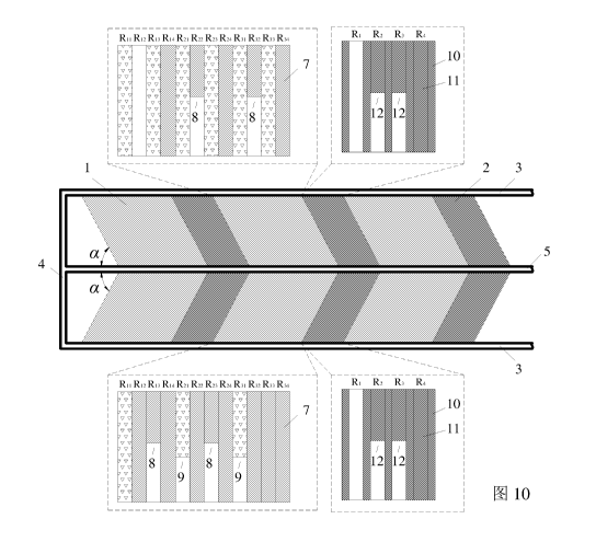
As shown in Fig. 10, in step 7, according to the mining sequence and principle
for the mining wide
roadways specified in the step 3 to step 6, a plurality of mining faces 8 and
12 are arranged
respectively in the "mining-backfilling" mining blocks 1 and the "mining-
reserving" mining blocks
2, and the mining wide roadways are mined simultaneously, and the mining wide
roadways that meet
the criteria specified in the step 5 are backfilled; at the same time, a
plurality of "mining-backfilling"
mining blocks 1 and "mining-reserving" mining blocks 2 are arranged in the
working face and mined
simultaneously, forming multi-heading parallel operation, till the mining of
the entire working face
is completed; Fig. 11 is a schematic diagram illustrating the completion of
mining and backfilling of
the entire working face.
Wherein, in the process of wide roadway mining in the "mining-backfilling"
mining blocks, the
backfilling ratio of the mining wide roadways in the "mining-backfilling"
mining blocks is controlled
11,)
Date recue / Date received 2021-11-26
CA 03142063 2021-11-26
by calculating whether the development of water-conducting fissures in the
overlaying strata
penetrates the confining stratum:
Assuming that the fissures in the overlying strata have developed to the nth
rock stratum above the
coal seam, and a unit rock mass is taken at the edge of fissure development,
the length of the unit
rock mass is ch, the height of it is 2y, the distance from the upper or lower
boundary of the unit rock
mass to the horizontal symmetry axis is y, and the left cross section and the
right cross section rotate
by cico relatively around the vertical symmetry axis during deformation, and
the curvature radius is p;
Under critical conditions, the strain of the lower boundary of the unit rock
mass of the rock stratum
is:
(P+Y)d9¨Pd9
6A8
/)d9
(1)
The ultimate strain of the rock stratum is:
12A/if ¨ AA
¨ __________________________________________
21212tE
(2)
where, hR is the thickness of the nth rock stratum, in unit of m; y is the
bulk density of the nth rock
stratum, in unit of kN/m3; hup is the development height of the fissures in
the nth rock stratum, in unit
of m; Lo is the width of the mining wide roadways, in unit of m; My is the
maximum bending moment
on the rock stratum, in unit of kN=m; Lo is the width of the branch roadways
in the stope, in unit of
m; E is the elastic modulus of the rock stratum, in unit of GPa;
The subsidence of the rock stratum, the width of the mining wide roadways, and
the curvature radius
meet the following geometric relationship:
µ
(p hap ¨ µ.2 + 4 + k)2ip
(3)
where, w is the subsidence of the rock stratum, in unit of m.
Thus:
4w1 elu+y4-2wh;E + AA4wM + yI4-2wh.2,E) ¨16wyL, (6M if4¨whE)
I' k = _____________________________ 1.274
(4)
The development height of the fissures in the overlaying strata is:
n-1
H = h +Eh.
up up
(5)
where, Hup is the development height of the fissures in the overlaying strata,
in unit of m; hi is the
thickness of the ith rock stratum above the coal seam (i=1, 2, 3...), in unit
of m.
According to the relevant theory of "equivalent mining height", the
relationship between the
11
Date recue / Date received 2021-11-26
CA 03142063 2021-11-26
development height of the fissures in the overlying strata and the backfilling
ratio can be expressed
in the form of a hyperbolic function, and a coefficient 2 is defined to
characterize the influence of the
backfilling ratio on the development of the fissures in the overlying strata.
Therefore, the Hup -
relationship is:
- M(1-0+2]2+ 22= 0
uP _
(6)
where, M is the thickness of the coal seam, in unit of m;
Based on the theory of equivalent permeability coefficient of the rock strata
in the permeation fluid
mechanics, the equivalent permeability coefficient of each rock stratum above
the water-conducting
fracture zone of the overlying strata is calculated respectively, and the
permeability change of the
equivalent confining bed of the overlying strata in the driving and
backfilling process of the mining
wide roadway is analyzed to judge whether the overlying strata can meet the
requirements of water-
preserved coal mining.
Wherein, in the driving process of the mining wide roadway in the "mining-
reserving" blocks, the
number of the mining wide roadway gobs is controlled by calculating the
ultimate strength of the
narrow coal pillars: the greater the number of the mining wide roadway gobs
is, the more easily the
narrow coal pillars become unstable. Based on the pressure arch theory and
ultimate strength theory,
the compressive stress above the narrow coal pillars is:
FN¨nykfe ______________________________ + S
2Sp f
(7)
where, EN is the compressive stress above the narrow coal pillars, in unit of
MPa; n is the number of
the mining wide roadway gobs; Sp is the width of the narrow coal pillars, in
unit of m; S, is the width
of the mining wide roadways, in unit of m;f is the Protodyakonov coefficient;
y is the average bulk
density of rock, in unit of N/m3; kf is the correction coefficient of pressure
arch.
the number n of the mining wide roadway gobs that can prevent instability of
the narrow coal pillars
in the "mining-reserving" blocks should meet the following criterion:
[a]S p f
n _________________________________________
rktF(Sp+Sc, )2
(8)
where, [a] is the compressive strength of the coal pillars, in unit of MPa; F
is the safety coefficient of
the coal pillars.
After the mining wide roadways are filled, the deflection curve of bending
deformation of the ith rock
stratum (i>2) above the immediate roof is regarded as a straight line, and the
subsidence area S , of the
top of the rock stratum can be expressed as:
= (nb I 2+ H cot 9)w, (0)
(9)
The maximum subsidence of the main roof is equal to that of the immediate
roof, i.e., w2(0)=U, then:
12
Date recue / Date received 2021-11-26
CA 03142063 2021-11-26
S2 = 411b I 2 + H2C0tOW (10)
Assuming that the subsidence areas of the rock strata above the main roof are
equal, i.e., Si¨S2(i>2),
then:
the subsidence of the top of the ith stratum above the immediate roof is as
follows:
(x) = (0) lx1
(nb 12+ I i cot 0)
=U (nb I 2 + cot()) Ix'
(i.?: 2)
(nb 1 2 + H, cot 0) (nb I 2 +H cot 0)
(11)
the horizontal deformation of the ith stratum above the immediate roof is as
follows:
= jwil (0)/(n02+ H COIL 0)2 ________________ +1¨i
(tib / 2 +1/,2 cot. 0)2 2
_____________________________________________ U + 1 - 1 (i 2)
(nb I 2+ Hi cot 0)'
(12)
Furthermore, owing to the fact that local stress concentration may occur
easily in the backfilling mass
and the narrow coal pillars in the bearing process, fractures may occur in
local positions, and the
fractures of the local positions will lead to differentiation and
discretization of the infrared radiation
temperature field and abrupt change of the infrared radiation index.
Therefore, in the mining process of the mining wide roadways in the step 4,
the backfilling process
of the mining wide roadways in the step 5, and the mining process of the
mining wide roadways II in
the step 6, an infrared thermal imaging system is utilized to observe surface
infrared radiation
information of the coal and rock mass at the mining faces, the surface
infrared radiation information
of the backfilling mass, and the surface infrared radiation information of the
coal and rock mass and
narrow coal pillars at the mining faces, so as to monitoring the locations of
the water bodies, water
inrush or water resource migration, stability of the backfilling mass, and
stability of the narrow coal
pillars 10 and provide warning.
If there is no abrupt change in the infrared radiation index, it indicates
that the backfilling mass and
coal pillars are stable; if the infrared radiation index changes abruptly (the
amplitude of the abruptly
changed index is 10 times of the amplitude before the abrupt change or
greater), it indicates that the
backfilling mass and the coal pillars will be unstable; thus, the dynamic
disasters of the coal and rock
can be predicted and forecast.
Furthermore, the deep circulation of hidden water in coal mine and its
infiltration into the surrounding
rock mass will cause changes in the temperature field of the bearing coal and
rock mass near the water
body, and thereby cause changes in the infrared radiation. However, the
essence and degree of such
changes are determined by the scale of the water body and the water pressure.
A water body has
different influences on the surface and interior of the driving space, ranging
from near to far, resulting
in different degrees of change in the infrared field strength at certain depth
inside the coal and rock
13
Date recue / Date received 2021-11-26
CA 03142063 2021-11-26
mass.
If the infrared radiation index changes gradually with the advancing of the
mining face, it indicates
that there is a water body ahead of the mining face; in that case, the
specific orientation of the water
body is detected with a geological radar; if the infrared radiation index
changes abruptly, i.e., the
amplitude of the abruptly changed index is 10 times of the amplitude before
the abrupt change or
greater, it indicates that water inrush will occur at the mining face; in that
case, an infrared thermal
imaging system is utilized to observe the infrared radiation information at
the mining face, so as to
predict the location of the water body and water inrush or water resource
migration and provide
warning.
A water resource migration monitoring and water disaster warning system,
comprising a long-range
detection system 13, a short-range observation system 14, a critical range
monitoring system 15, a
data acquisition system 16, a data analysis system 17-1, a water resource
migration evaluation system
17-2, and a water disaster warning system 17-3, wherein:
the long-range detection system 13 comprises a remote sensing satellite, an
unmanned aerial vehicle,
and remote sensing image processing software, and is configured to detect the
change of the surface
water system in the mining area caused by coal seam mining;
the short-range observation system 14 comprises a hydrological observation
borehole, a CT
observation borehole, a water level gauge, a water quality detector, a
groundwater flow or direction
meter, a roadway water gush monitor, and an advance detection borehole, and is
configured to observe
the condition of groundwater migration incurred by coal seam mining in real
time;
the critical-range monitoring system 15 comprises a borehole stress gauge and
an infrared explosion-
proof thermal imager, and is configured to monitor the water gush, stress and
temperature changes in
the stope during coal seam mining;
the data acquisition system 16 comprises data acquisition devices, a data
transmission system, system
substations and a master station, and is configured to collect the data
monitored by the long-range
detection system, the short-range observation system, and the critical-range
monitoring system to the
system substations and the master station through wireless and wired
transmission;
the data analysis system 17-1 analyzes the data collected in the database,
analyzes the parameters in
the mining area, including surface fissure distribution density (DL),
development height of fissures
in overlaying strata (FL), density of surface water network (SW), groundwater
level (DS), water
quality (QI), water gush in the mine shaft (YS), stope stress (YL) and
infrared radiation temperature
(WD), with preprogrammed computer programs, and generates multi-variable
correlation curves,
duration curves, and contour line according to different attribute data;
the water resource migration evaluation system 17-2 is an evaluation system
based on the data
analysis system, and can calculate a coal mining disturbance index (MI) and
establish a functional
relation with the water resource migration evaluation indexes with
mathematical techniques, namely:
M/ = (DL, FL, SIV ,DS,QI , VS)
(13)
in addition, it classifies the influence of coal mining on the water resources
in the mining area into
14
Date recue / Date received 2021-11-26
CA 03142063 2021-11-26
four levels according to the coal mining disturbance index: severe water
resource loss, moderate water
resource loss, slight water resource loss, and no influence, and thereby
evaluates the water resource
loss in the mining area incurred by coal mining;
the water disaster warning system 17-3 is a discrimination system based on the
data analysis system,
and it discriminates the indexes, including groundwater level (DS), water
quality (QI), water gush in
the mine shaft (YS), stope stress (YL) and infrared radiation temperature
(WD), and utilizes a multi-
source information comprehensive discrimination method, which is to say, when
a discrimination
index reaches the warning threshold, it analyzes the data of all
discrimination indexes, assigns a
corresponding risk rating, classifies different types of water disasters into
different levels, and
provides corresponding handling solutions against different levels.
A water resource migration monitoring and water disaster warning method,
comprising the following
steps:
step 1: carrying out aerial photography on the surface of the mining area by
means of a remote sensing
satellite and an unmanned aerial vehicle, and preprocessing the photographs,
such as correction,
cropping and stitching, with professional remote sensing image processing
software, so as to obtain
the data of surface water system and fissure distribution;
step 2: arranging a hydrological observation borehole 18 at an appropriate
location in the mining area,
mounting a water level gauge, a rapid water quality analyzer and a groundwater
flow or direction
meter at the phreatic water level or water-bearing stratum in the borehole to
collect the data such as
groundwater level, water quality, flow rate, flow direction and particle size,
etc.;
step 3: arranging a group of CT observation boreholes 19 on the ground surface
at 20m interval in the
advancing direction of the working face before mining; using every two
adjacent boreholes as a
transmitting borehole and a receiving borehole of the CT borehole detection
system respectively, and
observing the development of the fissures in the overlying strata that are not
disturbed by mining;
step 4: arranging a borehole stress gauge and an infrared explosion-proof
thermal imager at the coal
mining and heading faces respectively, and collecting the stope stress and
infrared radiation data in
real time in the coal seam mining process;
step 5: transmitting the data acquired by the monitoring devices to the
substations in the zones via a
data acquisition system 16 and finally uploading the data to the master
station of the system;
step 6: analyzing the data of each evaluation index by using a data analysis
system 17-1, to obtain the
law of change of each index;
step 7: evaluating the influence of coal mining on the loss of water resources
in the mining area by
using a water resource migration evaluation system 17-2, and adjusting the
mining method in time;
step 8: analyzing the collected data by using a water disaster warning system
17-3, to judge the risk
of various water disasters confronted in the mine production, define
corresponding warning levels for
different water disasters, and provide corresponding handling solutions.
Fig. 12 is a schematic diagram of the real-time water resource migration
monitoring and water disaster
warning system in the present invention; Fig. 13 is a top view of the real-
time water resource
migration monitoring and water disaster warning system in the present
invention.
Date recue / Date received 2021-11-26