Note: Descriptions are shown in the official language in which they were submitted.
CA 03144030 2021-12-17
WO 2020/260626 PCT/EP2020/068088
Sensor fusion
The present disclosure relates to a method, a processing device, a system, a
computer pro-
gram, a computer program and a computer non-volatile storage medium for
correcting remote
sensor data of an agricultural field.
Background
For precision farming the quality of plant, disease and pest models form the
basis to translate
data into actionable insights and automated operations on agricultural fields.
The quality of such
models is highly dependent on real world data. Two examples are satellite or
weather data. Par-
ticularly, for satellite images limitations in availability and quality due to
e.g. long revisit times,
cloud or atmospheric effects exist.
Accuracy and performance of modern plant and pest models are highly dependent
on several
field-specific high-quality weather and crop data. Today's weather models
already have a high
precision, however some specific field weather parameter with a high impact on
modeling needs
further improvement and ground-truth to reduce modeling errors caused by input
data. In partic-
ular, locations with field-specific microclimatic conditions benefit from
additional in-situ measure-
ments.
To further improve spray recommendations more elaborate techniques to enhance
data quality
are required. Additionally, data availability and reliability are pre-
requisites in modern farming to
safe operations on agricultural fields.
In regard of satellite image availability and quality, numerous market offers
for satellite-based
biomass and crop health analytics exist. However, those are all limited by
image availability and
quality. These issues are tried to be mitigated by increasing the number of
ingested satellite
products and incorporation of post-processing steps (e.g. atmospheric
correction). However,
these measures are affecting costs of those market offers.
Installation and maintenance of loT devices or non-stationary sensors is time
consuming. Exist-
ing offers usually require significant installation and high maintenance
efforts. This impacts
growers' resources, i.e. people can less focus on the agronomic learning
rather than keeping
the systems running and maintained.
In times of "Big Data" growers are very much concerned with collecting and
governing data
from their fields, however, this does not necessarily mean more insight and
more efficient farm-
ing practice. Digital farming platforms often lack the ability that digests
data and turn this into
practical insights and recommendations.
Remote sensor data is often used to provide additional data of the
agricultural field. Such re-
mote sensors providing the remote sensor data for example are satellites,
which are able to
CA 03144030 2021-12-17
WO 2020/260626 PCT/EP2020/068088
2
cover the entirety of an agricultural field. However, in particular to the
distance of the remote
sensor to the agricultural field, measurement errors might be introduced. For
example, atmo-
spheric distortions such as clouds might distort the remote sensor data.
Thus, there is a need for an improved method of obtaining remote sensor data
of an agricultural
field.
Invention
The following disclosure applies to the systems, methods, computer programs,
computer read-
able non-volatile storage media, and computer program products disclosed
herein alike. There-
fore, no differentiation is made between systems, methods, computer programs,
computer read-
able non-volatile storage media or computer program products. All features are
disclosed in
connection with the systems, methods, computer programs, computer readable non-
volatile
storage media, and computer program products disclosed herein.
According to one aspect of the invention, a method for correcting remote
sensor data of an agri-
cultural field is provided, the method comprises the following steps:
receiving remote sensor
data for the agricultural field from a remote sensor, wherein the remote
sensor data comprises
at least one remote measurement value corresponding to at least one location
that is measured
by the remote sensor at at least one point in time of obtaining the remote
measurement value;
receiving local sensor data for the agricultural field from at least one local
sensor, wherein the at
least one local sensor data comprises at least one local measurement value
corresponding to at
least one location of the at least one local sensor and corresponding to at
least one point in time
of obtaining the local measurement value correlating to the location and point
in time of obtain-
ing the remote measurement value; determining a correction model based on the
previously
received local sensor data and the previously received remote sensor data; and
determining
corrected current remote sensor data by applying the correction model to
current remote sensor
data.
The term "current remote sensor data", as used herein, relates to current
remote sensor data,
in particular satellite data, to which the correction model for determining
corrected current re-
mote sensor data is applied. In other words, the current remote sensor data
e.g. relates to live
remote sensor data, which are provided in real-time, e.g. by a satellite.
The terms "remote sensor data" and "local sensor data", as used herein, relate
to any sensor
data, including historic sensor data. In other words, the remote sensor data
and the local sensor
data describe the available sensor data used to determine the correction
model. It should be
noted that the remote sensor data and the local sensor data can be obtained
shortly before ob-
taming current remote sensor data, or long before obtaining current remote
sensor data.
The term "determining the correction model", as used herein, comprises
training and learning of
the correction model, in particular based on remote sensor data and local
sensor data.
CA 03144030 2021-12-17
WO 2020/260626 PCT/EP2020/068088
3
The term "corrected current remote sensor data", as used herein, relates to
current remote sen-
sor data, which have been corrected. Correcting the current remote sensor data
comprises an
amendment of the current remote sensor data or a validation of the current
remote sensor data.
In other words, in a scenario, in which the previously received local sensor
data indicate that the
previously received remote sensor data are already sufficiently accurate, the
correction model
determines based on the previously received local sensor data and the
previously received re-
mote sensor data that the previously remote sensor data do not have to be
amended. Conse-
quently, the correction model determines that the corrected current remote
sensor data are the
previously received remote sensor data without amending the previously
received remote sen-
sor data. Thus, the correction model validates the previously received remote
sensor data, or in
other words the correction model confirms a sufficient accuraccy of the
previously received re-
mote sensor data.
In a scenario, in which the previously received local sensor data indicate
that the previously
received remote sensor data are not sufficiently accurate, the correction
model determines
based on the previously received local sensor data and the previously received
remote sensor
data that the previously remote sensor data have to be amended. Thus, the
correction model
amends the previously received remote sensor data. The correction model is
provided with pre-
determined thresholds used for determining, if the previously received remote
sensor data al-
ready is sufficiently accurate in view of the previously provided local sensor
data.
In addition, the correction model is provided with a predetermined outlier
threshold used for de-
termining, if the previously received remote sensor data is an outlier. The
outlier will not be cor-
rected by the correction model but rather directly discarded.
The term "agricultural field", as used herein, comprises any kind of
commercially used area, in
particular forest area, meadows and farmland.
According to an embodiment, the remote sensor is disposed distant to the
agricultural field, for
example integrated in a satellite.
According to an embodiment, the local sensor is disposed near or in the
agricultural field.
According to an embodiment, the method, as described herein, is a computer-
implemented
method.
According to an embodiment, the correction model determines corrected current
remote sensor
data based on the current remote sensor data and current local sensor data.
Based on local sensor data, or in-situ field data, correction or projection
models may be deter-
mined leading to enhanced data quality or refined models. Both lead to more
robust model per-
CA 03144030 2021-12-17
WO 2020/260626 PCT/EP2020/068088
4
formance in the former case due to enhanced model inputs and in the latter
case due to refine-
ment of the model itself. The latter case may be particularly relevant for
weather models, growth
stage models, pest or disease models plus any zone-specific elements reflected
in such mod-
els. Such an approach provides benefits for the farmer in that the
recommendations provided
are tailored to the conditions present in a specific field and farmer's
efforts to visit the field are
reduced.
In one implementation, the local sensor, or on-site observation sensor,
provides at least one
measurement value relating to one or more condition(s) on an agricultural
field. In one imple-
nnentation the measurement value relates to weather, soil and/or crop
conditions in the agricul-
tural field. Examples of measured or derived weather conditions are air
temperature, humidity,
pressure, precipitation, wind, growing degree days. Crop conditions may be
measured or de-
rived through a spectrometer e.g. based on reflectance measurements to
determine a biomass
index, such as normalized difference vegetation index (NDVI), leaf area index
(LAI) or photo-
synthetically active radiation (PAR), or leaf wetness. NDVI for instance is
based on red and near
infrared spectral reflectance measurements acquired in the red (visible) and
near-infrared re-
gions, respectively. These spectral reflectances are ratios of the reflected
over the incoming
radiation in each spectral band individually, hence they take on values
between 0.0 and 1Ø
Soil conditions may include reflectance or in soil measurements relating to
nutrient content, soil
composition and the like. More than one condition on the agricultural field
may be measured
simultaneously by including respective sensor elements into the local sensor.
The remote sen-
sor data may include one or a combination of conditions mapped on a grid as
measurement
value and hence be comparable to the in situ in field or local sensor data.
In one embodiment, the local sensor provides a multiple-band spectrometer, air
temperature,
humidity, pressure, PAR, GPS coordinates, acoustic sonogram (sound
classification), tilt, com-
pass and/or, acceleration. Examples of data that can be derived from local
sensor are leaf tem-
perature from upwelling longwave, flowering or pollination from spectrometer
and photosynthe-
sis (A) from PAR, fraction of available PAR, and Light Use Efficiency (LUE).
Here, the first point in time may be viewed as the closest matching point in
time in both data
sets, namely the remote sensor data and the local sensor data. The remote
sensor data may
include a time series of satellite images. The remote sensor data may be a
multivariate time
series including e.g. a two-dimensional grid of measurement values such as
NDVI or LAI. The
local sensor data may include a time series of measurement values each
associated with the
location of the local sensor. The local sensor data may be a univariate time
series including e.g.
a one-dimensional chain of measurement values such as NDVI or LAI. According
to an embodi-
ment the location of the local sensor corresponds to a positioning value as
provided by a posi-
tioning system embedded into the local sensor. The positioning system e.g.
comprises a global
positioning system.
In one implementation, the local sensor may be non-stationary. Further the
location of the local
sensor may be a current or a corrected location. A corrected location may be
determined ac-
CA 03144030 2021-12-17
WO 2020/260626 PCT/EP2020/068088
cording to the method for correcting local sensor data received from the local
sensor, as de-
scribed herein.
In one implementation, local sensor data from multiple local sensors in
different locations of the
5 .. field or multiple univariate time series are received. If more than one
local sensor is placed in
the agricultural field in different locations of the field intra-field
variability is mapped, and local-
ization dependencies may be considered for the correction model. In one
implementation, local
sensors placed near the field of interest e.g. neighboring fields or in a
distance lower than a
threshold away from the field of interest may be considered.
In one implementation, the correction model is determined for more than one
point in time
and/or location. If the correction model is determined for more than one point
in time, local sen-
sor data and remote sensor data are matched according to a common time stamp.
In such a
case the correction model becomes time-dependent and potential in season
variations may be
reflected. If the correction is determined for more than one location, intra
field variability may by
reflected. A combination of time and location results in a more accurate
correction model reflect-
ing both, intra field variability as well as seasonal variations.
In one implementation, the correction model may be determined and applied to
remote sensor
data confined to the agricultural field of interest. Additionally or
alternatively the correction
model may be determined for remote sensor data confined to a first
agricultural field of interest
and applied to remote sensor data relating to a second agricultural field of
interest. In such a
case the correction model's applicability to e.g. neighboring fields or field
lying within a distance
of the first field may be validated. Such validation may be determined
empirically via a static or
pre-defined distance threshold. Alternatively or additionally such validation
may be determined
dynamically by analyzing observations in the region of interest with more than
one agricultural
field. In this context, the agricultural field may be specified by the field
boundary or the crop type
cultivated on the agricultural field. Applying the correction model to other
field allows for broader
application and adds the benefit for farmers. If for instance only one field
is equipped with local
sensors, the determined correction function may also be used for neighboring
fields not
equipped with such sensors.
Consequently, the current remote sensor data provided by a remote sensor is
systematically
corrected based on a trained correction model.
Combining spectral, in-situ time series from local sensor with satellite
imagery provides continu-
ous, high-precision monitoring of field zone biomass, enabling precision zone
spray solution that
will be available every-day.
Thus, more consistent and more accurate remote sensor data is provided.
Further, an improved
method for correcting remote sensor data of an agricultural field is provided.
In an embodiment, the local sensor is non-stationary.
CA 03144030 2021-12-17
WO 2020/260626 PCT/EP2020/068088
6
Thus, local sensor data or in-situ field data that is collected through a
local sensor placed on or
near to an agricultural field of interest in larger gridded data sets from
remote sensing is pro-
vided. The local sensor may be non-stationary. According to an embodiment, the
local sensor is
non-stationary in the sense that it is movable in the agricultural field by
being placed in intermit-
tent locations. Hence, for a first time period the local sensor may be placed
in a first location of
the field and for a second time period the local sensor may be placed in a
second location of the
field. For example, a farmer repositions the local sensor, when the local
sensor disturbs the
farming in his work. In other words, the farmer might reposition the local
sensor in a range of a
couple of meters. In both cases, the local sensor collects time series data,
which may be avail-
able on a certain time scale e.g. seconds, minutes, days, weeks, month or
years. In or in close
proximity to the field multiple local sensors may be placed. However, the
local sensors do not
cover the entirety of the agricultural field at every time.
Thus, an improved method for correcting remote sensor data of an agricultural
field is provided.
In an embodiment, the remote measurement value and/or the local measurement
value is asso-
ciated with a hyperspectral index or a biomass index.
In one implementation, the remote measurement value and e.g. the local
measurement value
may be associated with or may be a hyperspectral or a biomass index such as
NDVI. In such a
case the local sensor is e.g. equipped with a spectrometer, e.g. a multi-band
spectrometer mea-
suring at least in the red to infrared region. Additionally, the sensor may be
positioned above
and/or below the canopy. Above and below position allows to determine absolute
biomass in-
dices like LAI. In case of a non-stationary sensor, it may be placed on e.g. a
pole or a post ele-
vating the position of the sensor above the ground.
Thus, an improved method for correcting remote sensor data of an agricultural
field is provided.
In an exemplary embodiment, determining the correction model comprises the
following steps:
determining the remote measurement value corresponding to the location of the
at least one
local sensor; determining a difference between the remote measurement value
corresponding
to the location of the at least one local sensor and the local measurement
value of the at least
one local sensor for a plurality of points in time, wherein determining the
correction model is
further based on the determined difference.
According to an embodiment, the correction model determines an average
difference between
the remote measurement value and the local measurement value for a specific
location in the
agricultural field for a plurality of points in time. The correction model
then determines a cor-
rected remote measurement value, and thus corrected remote sensor data, for
each point in
time based on the determined average difference.
CA 03144030 2021-12-17
WO 2020/260626 PCT/EP2020/068088
7
Thus, a correction model is determined, that corrects the remote sensor data
more consistently
and more accurately.
Thus, an improved method for correcting remote sensor data of an agricultural
field is provided.
In an embodiment, the remote sensor data comprises at least one remote image,
which is
based on the at least one remote measurement value, wherein determining the
remote mea-
surement value corresponding to the location of the local sensor comprises the
following step:
extracting a pixel from the remote image that is closest to the location of
the local sensor or ex-
tracting a mean of pixels within a predefined distance of the pixel closest to
the location of the
local sensor; determining the remote measurement value based on the extracted
pixel, wherein
determining the correction model is also based on the extracted pixel on which
the remote mea-
surement value bases. The remote sensor data comprises at least one remote
image, which is
based on the at least one remote measurement value of the remote sensor data.
The remote
image preferably is a satellite image. Each pixel of the remote image relates
to a remote mea-
surement value.
In other words, the remote measurement value from remote sensor data
associated with the
location e.g. the current or corrected location, is determined by extracting a
pixel from the re-
mote sensor data that is closest to the location e.g. the current or corrected
location or by ex-
tracting a mean of pixels within a predefined distance of the pixel closest to
the location e.g. the
current or corrected location. For remote sensor data based on reflectance for
instance multiple
optical bands may be included. Based on the spectral response function of the
remote sensor
data and the local sensor data the measurement values from each data set may
be matched, if
the comparison is done on a band level. For relative measurement values, this
may not be re-
quired.
Consequently, more consistent and accurate remote sensor data is provided.
Thus, an improved method for correcting remote sensor data of an agricultural
field is provided.
In an embodiment, determining a difference between the remote measurement
value comprises
the following steps: receiving local time series data of the local sensor data
from the at least one
local sensor, wherein the local time series data comprises a plurality of
location data of a plural-
ity of points in time corresponding to the location, where the at least one
local sensor is located
at a specific point in time; determining a cluster of local sensor data based
on a maximal dis-
tance between the respective locations of the local sensors over time;
determining a clustered
location of the at least one local sensor based on the determined cluster;
determining the differ-
ence between the remote measurement value corresponding to the clustered
location of the at
least one local sensor and the local measurement value of the at least one
local sensor for a
plurality of points in time, wherein determining the correction model is
further based on the de-
termined difference.
CA 03144030 2021-12-17
WO 2020/260626 PCT/EP2020/068088
8
Once the clusters are determined, a new sensor data point may be checked, if
it lies within one
of the clusters. If a cluster is identified, the corresponding corrected
location associated with the
measurement value of the new sensor data point may be stored. If no cluster is
identified, this
may be flagged as device movement and/or the method for correcting local
sensor data may be
repeated to determine respective cluster center.
By correcting the location of each local sensor data point, inaccuracies in
the positioning system
of the local sensor can be avoided and the overall data quality for sensor
fusion improved. In
particular for movable local sensors, such inaccuracies have high impact on
the further process-
ing of the data and can induce additional errors. The method thus allows
matching the trajectory
of local sensor measurements with large-scale pixel or gridded data sets and
accounting for
random fluctuations in positioning system. Detecting physical device movements
(signal/noise)
is crucial in combining data from movable local sensors (e.g. a NDVI time
series) with other
sources (e.g. NDVI time series from satellites). In essence the detection of
physical sensor
movements is done through machine learning (e.g. hierarchical clustering), and
filtering of satel-
lite GPS signals.
In one implementation the clusters are determined based on at least one of the
cluster analysis
methods hierarchical clustering, particularly single-linkage hierarchical
clustering, centroid-
based clustering, distribution-based clustering or density-based clustering.
In one implementation, the determination of clusters is based on a distance
between locations
optionally including a pre-defined maximum distance to separate between
clusters.
Thus, an improved method for correcting remote sensor data of an agricultural
field is provided.
In an embodiment, the clustered location is determined by determining a center
of the cluster.
In one implementation, the determination of cluster centers may be based on a
distribution func-
tion. Here a simple radial distance or a maximum of the distribution function
may be defined as
cluster center.
Thus, an improved method for correcting remote sensor data of an agricultural
field is provided.
In an embodiment, the method comprises the following steps: if the received
remote time series
data comprises at least one gap, where remote sensor data at an expected point
in time in the
time series of remote time series data are missing, then receiving local
sensor data for the point
in time of the gap and determining predicted remote sensor data for the point
in time of the gap
based on the received local sensor data.
According to an embodiment, the correction model predicts the remote sensor
data, in particular
using a statistical model that is fed with the local sensor data and/or the
remote sensor data.
CA 03144030 2021-12-17
WO 2020/260626 PCT/EP2020/068088
9
Remote sensor data can be highly irregular and hence certain point in times
are missing in such
measurement. Generating remote sensor data for such missing point in times
allows to provide
the farmer with more current information on the field status, more accurate
modelling in such
gaps and hence more accurate recommendations or decisions. In this context
gaps include
missing remote sensor data between two points, where remote sensor data is
available, or
missing remote sensor data following one point, where remote sensor data is
available. Hence
the method allows projecting current remote sensor data into the future until
the next set of re-
mote sensor data is received. Thus, the method allows to increase data
availability and to pro-
vide the farmer with a current, up-to-date view on the field despite the
irregularity of remote sen-
sor data.
Thus, even large gaps can be filled out with predicted remote sensor data.
Further, more fre-
quent images from remote sensors can be provided even if not current remote
sensor data is
available.
Thus, an improved method for correcting remote sensor data of an agricultural
field is provided.
In an embodiment, determining the predicted remote sensor data comprises:
Receiving remote
sensor data of a point in time just before the gap and determining the
predicted remote sensor
data based on the received remote sensor data of the point in time just before
the gap.
Thus, a simple solution is provided for estimating the predicted remote sensor
data. Further, an
improved method for correcting remote sensor data of an agricultural field is
provided.
In an embodiment, the correction model comprises a projection function
depending on historical
data sets of remote sensor data and local sensor data, wherein the predicted
remote sensor
data is determined based on the projection function.
In other words, the projection function is determined for a time series of
local sensor data up to
the gap. A time dependent projection function may be generated taking account
of e.g. sea-
sonal variations. Here time series modelling techniques such as
autoregression, Bayesian tech-
niques or more sophisticated recurrent neural networks such as long short-term
memory
(LSTM), echo state network (ESN), ordinary differential equations (ODE) or
stochastic partial
differential equations (SPDE). Additionally, gaussian process regression
techniques may be
used to take account of the irregular or discontinuous nature of remote sensor
data.
Thus, an improved method for correcting remote sensor data of an agricultural
field is provided.
According to another aspect of the invention, a processing device is
configured for receiving
remote sensor data for the agricultural field from a remote sensor, wherein
the remote sensor
data comprises at least one remote measurement value corresponding to at least
one location
that is measured by the remote sensor at at least one point in time of
obtaining the remote mea-
surement value; receiving local sensor data for the agricultural field from at
least one local sen-
CA 03144030 2021-12-17
WO 2020/260626 PC
T/EP2020/068088
sor, wherein the at least one local sensor data comprises at least one local
measurement value
corresponding to at least one location of the at least one local sensor and
corresponding to at
least one point in time of obtaining the local measurement value correlating
to the location and
point of time of obtaining the remote measurement value, determining a
correction model based
5 on the previously received local sensor data and the previously received
remote sensor data;
determining corrected current remote sensor data by applying the correction
model to current
remote sensor data.
Thus, an improved method for correcting remote sensor data of an agricultural
field is provided.
According to another aspect of the invention, a system for correcting remote
sensor data of an
agricultural field comprises a remote sensor, configured for providing remote
sensor data for the
agricultural field from a remote sensor, wherein the remote sensor data
comprises at least one
remote measurement value corresponding to at least one location that is
measured by the re-
mote sensor at at least one point in time of obtaining the remote measurement
value; a local
sensor, configured for providing local sensor data for the agricultural field
from at least one local
sensor; wherein the at least one local sensor data comprises at least one
local measurement
value corresponding to at least one location of the at least one local sensor
and corresponding
to at least one point in time of obtaining the local measurement value
correlating to the location
and point of time of obtaining the remote measurement value; and a processing
device, as de-
scribed herein.
According to another aspect of the invention, a computer program is provided
comprising com-
puter readable instructions, which when loaded and executed by a processing
device perform
the methods, as described herein.
According to another aspect of the invention, a computer readable non-volatile
storage medium
is configured for storing a computer program, as described herein.
According to another aspect of the invention, a use of remote sensor data for
the agricultural
field and local sensor data for the agricultural field in a method, as
described herein, is provided.
In one implementation, a method for correcting remote sensing data of an
agricultural field of
interest based on local sensor data from on-site observation sensor is
provided, the method
comprising the following steps: receiving, via a communication interface,
local sensor data for
the agricultural field of interest, wherein the local sensor data includes at
least one first time
point, at least one measurement value and a location of the observation
sensor; receiving, via a
communication interface, remote sensor data for the agricultural field of
interest including the
same or a derived measurement value in relation to the local sensor data for
the at least one
first time point; determining, via a processing unit, a correction model based
on the measure-
ment value from remote sensing data associated with the current or corrected
location of the
local sensor data and based on the measurement value of the local sensor data;
applying, via
CA 03144030 2021-12-17
WO 2020/260626 PCT/EP2020/068088
11
the communication interface, the correction model to the remote sensing data
and provide cor-
rected remote sensing data.
In one implementation, the observation sensor is non-stationary or stationary.
In one implementation, the location of the observation sensor is a current or
a corrected loca-
tion.
In one implementation, the measurement value is associated with a
hyperspectral or a biomass
index.
In one implementation, the measurement value from remote sensing data
associated with the
location is determined by extracting a pixel from the remote sensing data that
is closest to the
location or by extracting a mean of pixels within a predefined distance of the
pixel closest to the
location.
In one implementation, wherein the correction model is determined for more
than one time point
and/or location.
In one implementation, a method for correcting local sensor data received from
an on-site ob-
servation sensor, in particular from a locally non-stationary sensor, further
in particular movable
with intermittent location is provided, the method comprising the following
steps: receiving, via a
communication interface, time series data from the on-site observation sensor,
wherein the time
series data includes for each time point at least one measurement value
associated with a loca-
tion; determining, via the processing unit, one or more clusters in the time
series data based on
the location; determining, via a processing unit, for each determined cluster
a cluster center;
providing, via the communication interface, the determined cluster center as
corrected location
associate with each measurement value in each cluster.
In one implementation, on receipt of a new sensor data point, the new sensor
data point is
checked, if it lies within one of the determined clusters. If the new sensor
data point does not lie
within one of the determined clusters, it is assumed that a local sensor has
been significantly
repositioned. Consequently, a new cluster is determined, and a determination
of a correspond-
ing cluster center is repeated.
In one implementation, a method for filling gap(s) in a time series of remote
sensing data based
on local sensor data is provided, the method including the following steps:
receiving, via a com-
munication interface, a time series of remote sensing data from a database
with gaps, for which
no remote sensing data exists; receiving, via a communication interface, local
sensor data for at
least time point lying in the gap; determining, via a processing unit, remote
sensing data for time
points in the gap based on remote sensing data just before the gap and
received local sensor
data during the gap using a projection function, wherein the projection
function is parametrized
according to historical data sets of remote sensing data and local sensor
data; providing, via the
CA 03144030 2021-12-17
WO 2020/260626 PCT/EP2020/068088
12
communication interface, projected remote sensing data at the identified point
in time, where no
remote sensing data exists.
In one implementation, a system for correcting remote sensing data of an
agricultural field of
interest based on local sensor data from on-site observation sensor is
provided, the system
comprising a communication interface and a processing unit configured to:
receiving, via a com-
munication interface, local sensor data for the agricultural field of
interest, wherein the local sen-
sor data includes at least one first time point, at least one measurement
value and a location of
the observation sensor; receiving, via a communication interface, remote
sensor data for the
agricultural field of interest including the same or a derived measurement
value in relation to the
local sensor data for the at least one first time point; determining, via a
processing unit, a cor-
rection model based on the measurement value from remote sensing data
associated with the
current or corrected location of the local sensor data and based on the
measurement value of
the local sensor data; applying, via the communication interface, the
correction model to the
remote sensing data and provide corrected remote sensing data.
In one implementation, a system for correcting local sensor data received from
an on-site obser-
vation sensor, in particular a locally non-stationary sensor, further in
particular movable with
intermittent location, is provided, the system comprising a communication
interface and a pro-
cessing unit configured to: receiving, via a communication interface, time
series data from the
on-site observation sensor, wherein the time series data includes for each
time point at least
one measurement value associated with a location; determining, via the
processing unit, one or
more clusters in the time series data based on the location; determining, via
a processing unit,
for each determined cluster a cluster center; providing, via the communication
interface, the
determined cluster center as corrected location associate with each
measurement value in each
cluster.
In one implementation, a system for filling gap(s) in a time series of remote
sensing data based
on local sensor data, is provided, the system comprising a communication
interface and a pro-
cessing unit configured to: receiving, via a communication interface, a time
series of remote
sensing data from a database with gaps, for which no remote sensing data
exists; receiving, via
a communication interface, local sensor data for at least one time point lying
in the gap; deter-
mining, via a processing unit, remote sensing data for time points in the gap
based on remote
sensing data just before the gap and received local sensor data during the gap
using a projec-
tion function, wherein the projection function is parametrized according to
historical data sets of
remote sensing data and local sensor data; providing, via the communication
interface, pro-
jected remote sensing data at the identified point in time, where no remote
sensing data exists.
In one implementation, a computer program or computer readable non-volatile
storage medium
comprising computer readable instructions is provided, which when loaded and
executed by a
processing device perform the methods, as described herein.
CA 03144030 2021-12-17
WO 2020/260626 PCT/EP2020/068088
13
The provided method and system for example has the following relevance for
practical farming.
In regard of field zone specific relevance, using the ground truth, in-situ
measurements to cali-
brate zoning algorithm by fusing satellite data and in-situ hyperspectral
measurements results in
more accurate and consistent data for zoning. In regard of continuous
monitoring relevance, us-
ing spectral information from local sensor in conjunction with satellite data
allows continuous,
spatially explicit monitoring of plant health and growth at the field zone
level.
The provided method and system for example has the following benefits for farm
operations and
farm labor. Improved logistics is provided due to the everyday availability of
variable rate pre-
scription maps for e.g. fungicide treatments growers do not need to plan their
logistics around
satellite image availability. Improved flexibility is provided. Non-stationary
local sensors are
highly movable, easy to install devices. Depending on seasonal progress local
sensor can be
installed on different fields, e.g. for Ti, T2 or T3 cereal fungicide
application. Improved effi-
ciency is provided. Seamless, 1-click solution interoperability saves time,
reduces installation
stress factor and onboarding efforts. Improved maintenance is provided:
Hundreds installed
units confirm, the non-stationary local sensor and the system requires no
maintenance.
The provided method and system for example has the following benefits for
environment and
energy. The non-stationary local sensor may use solar power, instead of
batteries. More effec-
tive spraying helps farmers to act eco-friendly by reducing crop input and
optimizing operations.
The provided method and system for example has the following impact on labor
efficiency and /
or labor safety. When well positioned in the field, farmers can reduce the
efforts to visit fields
and we can trigger much better targeted field visits, if needed at all.
Figures
Exemplary embodiments are shown in the drawings with
Figure 1 depicting an exemplary embodiment of NDVI vs time from remote sensor
data and
local sensor data;
Figure 2 depicting an exemplary embodiment of another NDVI vs time from remote
sensor data
and local sensor data;
Figure 3 depicting an exemplary embodiment of predicted satellite
measurements;
Figure 4 depicting an exemplary embodiment of predicted satellite measurements
with rejec-
tions;
Figure 5 depicting an exemplary embodiment of another NDVI vs time from remote
sensor data
and local sensor data with a cut off;
Figure 6 depicting an exemplary embodiment of NDVI vs time from remote sensor
data and
local sensor data with a prediction from the cut off;
Figure 7A depicting an exemplary embodiment of location data from non-
stationary local sen-
sor;
Figure 78 depicting an exemplary embodiment of clustered location data from
non-stationary
local sensor; and
Figure 8 depicting an exemplary embodiment of a flow chart for sensor fusion.
CA 03144030 2021-12-17
WO 2020/260626 PCT/EP2020/068088
14
Embodiments of the invention
Figure 1 depicts an exemplary embodiment of a normalized difference vegetation
index, NDVI,
over time, in form of different dates, from remote sensor data DR, in
particular satellite measure-
ments, and local sensor data DL and highlights the differences particularly
for a first image 1, a
second image 2, a third image 3, a fourth image 4 and a fifth image 5 strongly
diverging from
local sensor data, which is a sign of atmospheric distortions such as clouds.
Figure 2 depicts an exemplary embodiment of another NDVI over time from remote
sensor data
DR and local sensor data DL. In view of the NDVI of each image, the remote
sensor data DR in
particular deviate from the local sensor data DL in a first data point Si, a
second data point S2,
a third data point S3, a fourth data point 04 and a fifth data point S5. This
again is a sign of at-
mospheric distortion such as clouds.
Figure 3 depicts an exemplary embodiment of the remote sensor data DR and the
local sensor
data DL of figure 2. In general, the remote sensor data DR have a lower NDVI
as the local sen-
sor data DL, as the remote sensor data DR usually are determined by a
satellite and distortions
like atmospheric distortions have a higher impact on the remote sensor data DR
than on the
local sensor data DL. Consequently, the remote sensor data DR introduce a
systemic underesti-
mation of the real condition. This systemic underestimation difference in NDVI
is overcome by
correcting the remote sensor data, in this case current remote sensor data, to
corrected current
remote sensor data DRC based on the local sensor data DL and the remote sensor
data DR.
According to an embodiment, a correction model or prediction model, in
particular a machine
learning model, determines the corrected remote sensor data DRC. In other
words, the sys-
temic underestimation difference of the local sensor data DL and the remote
sensor data DR is
determined and added to the remote sensor data DR to determine the corrected
remote sensor
data DRC. In other words, the values of the remote sensor data DR are
increased by the deter-
mined systemic underestimation difference in NDVI. In this case, it is
determined that in aver-
age over the analyzed time, the local sensor data DL have an NDVI that is 0.1
higher than the
remote sensor data DR. Consequently, each data point of the remote sensor data
DR is in-
creased by 0.1 to arrive at the corrected remote sensor data DRC. In the
graph, the remote sen-
sor data DR are shifted up by 0.1. The systemic underestimation difference can
alternatively be
a predetermined value, for example from former test cycles. Thus, the
corrected remote sensor
.. data DRC indicate a corrected version of the remote sensor data DR.
Figure 4 depicts an exemplary embodiment of the remote sensor data DR and the
local sensor
data DL of figure 3. In addition to only determining reasonable corrected
remote sensor data
DPC, the correction model is configured for detecting outliers in the remote
sensor data DR. As
described in figure 3, a first data point Si, a second data point S2, a third
data point S3, a fourth
data point D4 and a fifth data point S5 deviate heavily from the corresponding
local sensor data
DL. The correction model compares the measurement values or in other words the
NDVI val-
ues, of the remote sensor data DR and the local sensor data DL in each point
in time and deter-
CA 03144030 2021-12-17
WO 2020/260626 PCT/EP2020/068088
mines outliers if the difference of the remote sensor data DR and the local
sensor data DL ex-
ceed a threshold. This threshold can be predetermined. Alternatively, the
threshold can be dy-
namically adjusted by the correction model. Consequently, the determined
outliers are not con-
sidered anymore, as they most likely correspond to unreasonable images. Thus,
the correction
5 model determines corrected remote sensor data with corrections DRCC,
wherein the outliers of
the remote sensor data DR are replaced by the correction model by corrected
data points based
on the corrected remote sensor data DRC and the local sensor data DL.
Alternatively, instead of
the rejected image that caused the outlier NDVI data, the correction model
takes the NDVI of
the last non-rejected image from the satellite to determine the corrected
remote sensor data
10 with corrections DRCC.
Figures 5 and 6 depict an exemplary embodiment of further local sensor data DL
and remote
sensor data DR overtime. In this case, it is assumed that after a cut off C,
no more satellite im-
ages, and thus no more remote sensor data DR are available. Thus, the
correction model pre-
15 dicts predicted sensor data DP based on the local sensor data DL after
the cut off as well as the
local sensor data DL and the remote sensor data DR before the cut off.
Consequently, the cor-
rection model can fill out gaps for remote sensor data that are missing.
Figure 7A shows an exemplary embodiment of location data from non-stationary
local sensor.
The measurement error in the locations of the sensor device are highlighted
via the reported
observations of the locations of the device that vary. Hence, the unique
location of the sensor
devices has to be found via e.g. single-linkage hierarchical clustering
algorithm. In identified
clusters points are merged with minimal distance and a stop is introduced at a
specified maxi-
mal distance. Figure 7B shows the clustered location data from non-stationary
local sensor.
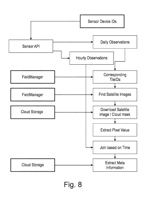
Figure 8 shows an exemplary embodiment of a flow chart for sensor fusion. To
find correspond-
ing satellite data for the local sensor data hourly, daily data for all
available times / dates are
extracted, in particular via a sensor application programming interface,
sensor API. Based on
daily data corresponding sensor device IDs from remote sensor data, in
particular satellite data,
for each observation are identified. Given the sensor device IDs corresponding
data is retrieved
from a field manager to find satellite data, or in other words satellite
images, matching the date
of the observation.
The field manager comprises a field related database, in which the local
sensor data is stored,
as well as a decision support system for finding the relevant satellite data.
Alternatively, the lo-
cal data is stored in a cloud storage. Then a download of the surrounding
pixels of the image for
the location of the local sensor device is conducted. The download is
conducted from a cloud
storage, in which the satellite data is stored. The cropped satellite images
for visual analysis
may be stored and correct pixel values in relation to the local sensor data
are identified. Based
on the time of the satellite image and the local observations are joined.
Lastly meta information
of the satellite image (i.e. angle of the satellite) may be extracted.
CA 03144030 2021-12-17
WO 2020/260626 PCT/EP2020/068088
16
In one embodiment, the methods disclosed herein provide field zone management
solution
combining in-field local sensor data from e.g. non-stationary local sensor,
with satellite-based
biomass and crop health indices. Using local sensor data, leads to more
accurate zone spray
and allows for increased biomass, crop health maps and variable rate
prescription map avail-
ability.
Crop optimization platforms may include all the way from data collection and
generation,
through agronomic modelling, deriving insights to recommending action. With
such platforms a
grower knows when, where and how much to apply (e.g. fungicides). Certain
further functionali-
ties may include on in field variability in application or spray maps, and
further instructions on
e.g. the tank mix and the optimal treatment window for variable rate
application. This may be
particularly useful for fungicides. Monitoring functionalities may enable
growers to inspect and
compare plant growth and health across time and fields - daily and from every
on the planet
using our web and mobile solutions.
Local sensors (e.g. non-stationary) may by smart in the sense of having
multiple sensor ele-
ments, highly-moveable, easy-to-install loT devices with sensor elements such
as spectrome-
ters or acoustic distrometers that is solar powered. Due to their design and
manufacturing they
may be virtually maintenance free.
By combining crop optimization platform with an in-field local sensor (e.g.
non-stationary) the full
automation and scalability potential of such platform yet backing up precise
biomass, crop
health analytic maps and variable rate application maps with the ground truth
data may be ex-
ploited.
Trials support that this reduces biases e.g. in satellite-derived biomass and
crop health indices.
Additionally, through smartly combing satellite with local sensor data issues
in satellite image
availability can be overcome.
To keep the onboarding of the local sensor (e.g. non-stationary) into a
platform simple, seam-
less 1-click solution may be included in the platform. This provides
convenience of having a
one-stop-shop solution for inspecting how crops grow and taking actions based
on the platform
supported by in-field data from the local sensor.