Note: Descriptions are shown in the official language in which they were submitted.
CA 03144544 2021-12-21
WO 2020/257948
PCT/CA2020/050903
SYSTEM AND METHOD FOR OPTICAL LOCALIZATION
TECHNICAL FIELD
[001] The present disclosure relates to autonomous mobile robots, particularly
a
localization system for mobile robots using optical devices.
BACKGROUND
[002] Robotic vehicles may be configured for autonomous or semi-autonomous
operation for a wide range of applications including product transportation,
material handling, security, and military missions. Autonomous mobile robotic
vehicles typically have the ability to navigate and to detect objects
automatically
and may be used alongside human workers, thereby potentially reducing the cost
and time required to complete otherwise inefficient operations such as basic
labor,
transportation and maintenance. An important part of robotic autonomy is
robot's
ability to reliably navigate within a workspace. Numerous positioning system
approaches are known that attempt to provide accurate mobile robot positioning
and navigation without the use of GPS. Some autonomous vehicles track
movement of driven wheels of the vehicle using encoders to determine a
position
of the vehicle within a workspace. Other autonomous vehicles use other
approaches such as GPS-pseudolite transmitters, RF beacons, ultrasonic
positioning, active beam scanning and landmark navigation.
[003] In particular, a landmark navigation system uses a sensor, usually a
camera, to determine a vehicle's position and orientation with respect to
artificial
or natural landmarks. Artificial landmarks may be deployed at known locations
and certain systems contemplate artificial landmarks that involve the use of a
high
contrast bar code or dot pattern. A sensor device can observe both the
orientation and distance relative to the landmark, so that only two landmarks
need
to be viewed in order to compute the vehicle's position. The challenge in a
landmark navigation system is in reliably identifying the landmarks in
cluttered
scenes. The accuracy of the position computation is dependent on accurately
determining the camera orientation to the landmark. Also, sufficient
illumination is
necessary With existing landmark navigation solutions.
CA 03144544 2021-12-21
WO 2020/257948
PCT/CA2020/050903
[004] Nevertheless, landmark navigation is attractive because of its potential
for
accuracy, high reliability, low cost and relative ease of deployment. There
is,
therefore, a need for an improved landmark navigation positioning system that
can
achieve the reliability and accuracy that current positioning system solutions
for
robotic or unmanned vehicles cannot.
[005] The proposed optical system of localization for mobile robots can
provide
additional accuracy and reliability over existing methods of localization
(such as
those relying on Ultra Wideband ("UWIEr) localization), and additionally can
potentially use the same sensors for obstacle detection and avoidance, for
example.
SUMMARY
1[006] In accordance with one disclosed aspect, there is provided a system for
optical localization. The system includes a plurality of movable stationary
landmarks defining an operating space and an autonomous mobile robot located
in and operating within the operating space. The mobile robot includes a self-
propelled mobile chassis, an optical sensor assembly disposed on a raised
portion
vertically spaced apart from the chassis and configured to detect at least one
of
the plurality of landmarks, and a controller configured to determine the
position
and orientation of the chassis based at least on information from the optical
sensor assembly. The optical sensor assembly may include a LiDAR sensor or
an optical camera. Each landmark of the plurality of landmarks may be in the
form of a structure having an elevated portion extending vertically from the
ground
surface to a height level which is equal to or higher than a horizontal plane
parallel
to the surface and extending from the optical sensor assembly of the mobile
robot,
wherein the elevated portion is optically detectable by the optical sensor
assembly. Each landmark of the plurality of landmarks may have one or more of:
a characteristic cross-sectional feature for determining orientation of the
optical
sensor assembly/mobile robot) relative to the landmark; a characteristic
visually
distinct portion for determining orientation (of the optical sensor
assembly/mobile
robot) relative to the landmark; and an identifier uniquely identifying the
landmark
from other landmarks. The optical sensor assembly may be mounted on an
actuated column vertically movable between an extended portion where the
2
CA 03144544 2021-12-21
WO 2020/257948
PCT/CA2020/050903
optical sensor assembly is vertically spaced apart from the chassis and a
retracted position where the optical sensor assembly is held relatively near
the
ground.
[007] In accordance with another disclosed aspect, there is provided a method
for optical sensor-based localization of an autonomous mobile robot. The
method
involves detecting, by an optical sensor assembly, an optical reference,
determining, by a processing unit, based on the detected optical reference - a
distance to the optical reference, a relative angle to the optical reference,
and an
orientation of the optical reference; and calculating, by the processing unit,
the
orientation and position of the mobile robot based on the detected distance,
orientation, and relative angle of the optical reference using a known
relationship
between the mobile robot, the optical sensor assembly, and the detected
optical
reference. The method may further include moving the optical reference, while
keeping the optical sensor assembly stationary or moving the optical sensor
assembly, while keeping the optical reference stationary; tracking, by the
processing unit, the relative movement of the optical reference to the optical
sensor assembly and information regarding which of the optical reference or
optical sensor assembly was moved, and determining, by the processing unit, a
new position and orientation of the mobile robot based on the detected
distance
and relative angle of the optical reference using a known relationship between
the
mobile robot, the optical sensor assembly, and the detected optical reference,
the
tracked relative movement of the optical reference the sensor assembly, and
the
information regarding which of them was moved. The known relationship may be
either a static relationship defined at initialization, or a dynamic
relationship which
may change during operation and be communicated to the processing unit.
[OM In accordance with a further disclosed aspect, there is provided a method
for optical sensor-based localization of an autonomous mobile robot during
operation. The method involves detecting, by an optical sensor assembly of a
mobile robot located at a first position, a first optical reference and a
second
optical reference, determining, by a processor, based on the detected optical
references - a distance to each optical reference, and a relative angle to
each of
the detected optical references; calculating, by the processor, the
orientation and
3
CA 03144544 2021-12-21
WO 2020/257948
PCT/CA2020/050903
position of the mobile robot based on the detected distances and relative
angles
of the optical references, detecting, by the optical sensor assembly, further
optical
references, calculating, by the processor, the position of each further
optical
reference with respect to the first and second optical references, moving, by
the
mobile robot, from the first position to a second position, detecting, by the
optical
sensor assembly, at least two previously detected optical references, and
calculating, by the processor, the orientation and position of the mobile
robot
based on the detected distances and relative angles of any two of the detected
optical references.
[009] The method may further involve establishing, by the processor, a global
coordinate system based on the detected optical references. The method may
then include detecting, by a second sensor of the mobile robot, one or more
objects, calculating, by the processor, the position of each of the detected
objects
with respect to the optical references by - determining, by the processor, the
relative position of the second sensor to the mobile robot, determining, by
the
second sensor, the position of each object relative to the robot, and
transforming,
by the processor, the position of each object relative to the second sensor to
the
global coordinate system; and storing, by the processor, the calculated
positions
with respect to the global coordinate system in a memory. The method may also
involve storing, by the processor, the relative positions of each of the
detected
optical references in a memory, and determining, by the processor, the
identity of
features detected by the optical sensor assembly as optical references based
on
at least the stored relative positions of the optical references stored in the
memory. The method may additionally involve detecting, by the optical sensor
assembly, an optical feature of a second mobile robot, determining, by the
processor, based on the detected optical feature one or more of a distance to
the
second mobile robot and an orientation of the second mobile robot,
calculating, by
the processor, the orientation and position of the second mobile robot
relative to
the optical references based on the detected distances and relative angles of
the
optical feature, and maintaining, by the mobile robot, a minimum distance of
separation to the second mobile robot. The method may then also involve
communicating, by the processor of the mobile robot through a communication
device on the mobile robot, with the processor of the second mobile robot
through
4
CA 03144544 2021-12-21
WO 2020/257948
PCT/CA2020/050903
a communication device on the second mobile robot, and transmitting, by the
processor of the mobile robot, the orientation and position of the second
mobile
robot relative to the optical references.
[001 0] in
accordance with yet another disclosed aspect, there is provided a
method for initializing a system for optical localization of an autonomous
mobile
robot. The method involves placing at least three optical references, the
placement of the optical references forming a predetermined angle, concealing
two optical references defining a width of an operating space from an optical
sensor assembly of a mobile robot, detecting, by the optical sensor assembly,
an
environment of the operating space, unmasking the two optical references to
the
optical sensor assembly and detecting, by the optical sensor assembly, the two
optical references, and determining, by a processor of the mobile robot, the
width
of the operating space based on the distance between the two detected
unmasked optical references. The method then involves rotating, by the mobile
robot, searching for and detecting, by the optical sensor assembly, the third
optical reference, selected based on the relative angle of the location of the
third
reference with respect to the line formed by the two detected unmasked optical
references, and defining, by the processor of the mobile robot, the length of
the
operating space as a perpendicular distance between the detected third optical
reference and the line formed by the two detected unmasked optical references.
[001 1] in
accordance with another aspect, also disclosed herein is a
method for expanding an operation space of a mobile robot. This method
includes determining, by a processing unit, that the mobile robot has
completed a
work task in the operating space followed by assigning, by the processing
unit, a
relocation task to the mobile robot, the relocation task comprising moving one
or
more landmarks of a plurality of landmarks from a first position of each of
the one
of more landmarks to a second position of each of the one or more landmarks.
The method then includes executing, by the mobile robot, the relocation task,
the
task involving navigating, by the mobile robot, to a first landmark of the one
or
more landmarks located at a first position using the disclosed optical
localization
system comprising the plurality of landmarks, transporting, by the mobile
robot,
the first landmark to a second position for the landmark, comprising
navigating
5
CA 03144544 2021-12-21
WO 2020/257948
PCT/CA2020/050903
using the optical localization system, and repeating from the navigating step
for
each other landmark of the one or more landmarks to be moved. The method
then includes assigning, by the processing unit, a new work task to the mobile
robot in the operating space defined by new landmark positions. in this
manner,
once the work task (e.g. a method of transportation of articles) has been
completed for one operating space, the mobile robot can automatically define a
new operating space, and perform the work task in the new operating space,
without requiring human intervention.
BRIEF DESCRIPTION OF THE DRAWINGS
[0012] in the following, embodiments of the present disclosure will be
described with reference to the appended drawings.
However, various
embodiments of the present disclosure are not limited to arrangements shown in
the drawings.
[0013] Fig. 1 is a plan view of a system for optical localization.
[0014] Fig. 2 is a perspective view of an embodiment of an autonomous
mobile robot using the system for optical localization of Fig. 1.
[0015] Fig. 3 is a perspective view of an embodiment of a landmark used in
the system for optical localization of Fig. 1.
[0016] Fig. 4 is a side view of an alternative embodiment of an autonomous
mobile robot using the system for optical localization of Fig. 1.
[0017] Fig. 5 is a block diagram view of a method for optical localization.
[0018] Fig. 6 is a block diagram view of an alternative method for optical
localization.
[0019] Fig. 7 is a plan view of a system implementing a method of optical
localization.
[0020] Fig. 8 is a block diagram view of a method of initializing a system
for
optical localization.
6
CA 03144544 2021-12-21
WO 2020/257948
PCT/CA2020/050903
[0021 Fig. 9
is a schematic plan view illustrating a system implementing a
method for expanding the operating space of a mobile robot.
[0022] Figs.
10A and 10B are schematic plan views of an alternative
embodiment of a system implementing a method for expanding the operating
space of a mobile robot.
1[0023] Fig.
11 is a perspective view of an alternative embodiment of a
landmark operable with the disclosed system.
1[0024] Fig.
12 is a block diagram illustrating a method for expanding the
operating space of a mobile robot.
DETAILED DESCRIPTION
1[0025]
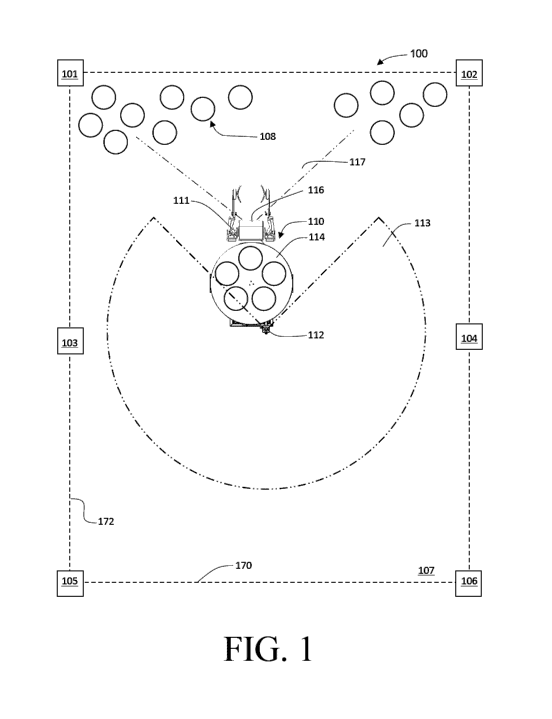
Referring to Fig. 1, a system for optical localization of an
autonomous mobile robot is shown generally at 100. The system 100 includes a
plurality of movable stationary landmarks 101, 102, 103, 104, 105, and 106
defining a work field 107. The work field 107 is defined by defining a base
line
170 and a field boundary 172. The base line 170 may define the start and end
positions for moving work for example, and provides a reference line for an
axis
for an x-y coordinate system, for example, in which a mobile robot is being
localized. The field boundary 172 determines the area a mobile robot 110 may
freely move in. The work field 107 may be defined at initialization in a
variety of
ways - for example, the mobile robot 100 may be provided the dimensions of the
work field 107 by an operator and the size of work field 107 is defined by
these
parameters, the robot 110 using odometry to stay within the boundaries and
only
using landmarks 101, 102, 103, 104, 105, 106 to correct odometry drift. In
another example, the work field 107 may be defined by providing the robot 110
with configuration information regarding the system such as the landmarks 101
and 102 defining one end of the work field 107 and the landmarks 105 and 106
defining the opposite end, with the base line 107 defined as the line between
landmarks 105 and 106, and the field boundary between landmarks 101 and 105,
running through landmark 103 as well as between landmarks 102 and 106 running
through landmark 104. In yet another example, the robot 110 may be provided
with configuration information that the work field 107 is defined by three
pairs of
7
CA 03144544 2021-12-21
WO 2020/257948
PCT/CA2020/050903
landmarks, with the base line 170 defined by the line running through third
pair of
landmarks (in this case landmarks 105 and 106), and the field boundary running
through the landmark of each pair on the same side. The system 100 may
additionally include a plurality of articles 108 (such as plant pots being
transported
by the mobile robot) located in the work field 107. The system 100 includes
the
autonomous mobile robot 110 also located in the work field.
[0026] The robot 110 includes a raised optical sensor 112 (sometimes also
referred to herein as an optical sensor assembly) mounted on a raised portion
of
the robot 110 and having a field of view 113, and may include a manipulator
111
for interacting with articles 108. The robot 110 may also include a storage
space
114 for storing articles, and a second optical sensor 116 mounted on the robot
110 and having a different field of view from the elevated optical sensor 112,
such
as the complementary field of view 117 shown in Fig. 1. The field of view 113
of
the raised optical sensor 112 is preferably around 270 degrees or greater,
allowing the sensor 112 to see two or more of the stationary landmarks 101,
102,
103, 104, 105, and 106 at any given time. For example, in Fig. 1, landmarks
103,
104, 105 and 106 are within the field of view 113. For a work field 107 of a
different size, there may be additional landmarks which extend along the lines
formed by landmarks 101, 103, 105 and by landmarks 102, 104, 106, for example.
[0027] Referring to Fig. 2, an embodiment of the mobile robot 110 of Fig. 1
is shown in greater detail. In other embodiments the mobile robot may be
unmanned aerial vehicles or other unmanned ground vehicles or any other mobile
robot. The raised optical sensor 112 can be seen attached to the top of a
tower
structure 118 of the mobile robot 110. The tower structure 118 may
additionally
house additional components, such as a communication system 119 allowing the
mobile robot 110 to communicate over a wireless network, for example. If
present
as in the depicted embodiment, the second sensor 116 may be mounted at a
different elevation on the mobile robot 110 than the raised optical sensor
112, and
may be useful in detecting obstacles at different heights, or for detecting
objects
such as articles 108 while the plane of view of the raised optical sensor 112
goes
over such objects. Each of sensors 112 and 116 may be a Light Detection and
Ranging (LiDAR) sensor, an optical camera, or a combination of the two. Both
8
CA 03144544 2021-12-21
WO 2020/257948
PCT/CA2020/050903
sensors 112 and 116 may also be used for other purposes, such as pathfinding,
object avoidance, safety, and data gathering for example.
[0028]
Referring to Fig. 3, an embodiment of a movable stationary
landmark such as landmarks 101, 102, 103, 104, 105 or 106 of Fig. 1 is shown
generally as 300. The landmark 300 includes an elevated portion 310, which
extends vertically so that the raised optical sensor 112 retains line of sight
to the
elevated portion 310 even if intervening objects are on the surface between
the
robot 110 and the landmark 300. The elevated portion 310 generally extends at
least to a height level which is equal or higher than a horizontal plane
parallel to
the surface extending from the raised optical sensor 112. The elevated portion
310 may have a characteristic cross-sectional geometry feature 311 so that a
LiDAR or other optical sensor operating at the horizontal plane parallel to
the
surface extending from the raised optical sensor 112 can distinguish the
landmark
300 from other objects having a cross-section at that plane. The
characteristic
feature 311 may additionally provide information on the relative angle of the
detecting sensor 112 to the landmark 300, such as in this case being a feature
(the chamfered edge) that exists only on a single edge of the cone, meaning
for a
given known orientation of the landmark 300, the relative angle to the
landmark
can be determined by finding the chamfered edge, for example. The landmark
300 may additionally include a visually distinct portion 312, such as a
striped face.
The striped face may contain material with different (enhanced) reflectivity
compared to the rest of the landmark and the surrounding environment, for
example, to produce a distinct increase in reflective intensity in a
particular
wavelength - under either or both of optical lighting and LiDAR. The visually
distinct portion 312 serves a similar purpose as the characteristic feature
311, for
either or both of an optical camera version of sensor 112 or the LiDAR version
of
sensor 112. The visually distinct portion 312 may assist the processing
algorithm
of the sensor 112 in distinguishing the landmark 300 from background objects.
Similarly, the visually distinct portion 312 may additionally provide
information on
the relative angle of the detecting sensor 112 to the landmark 300, since like
the
characteristic feature 311, the portion 312 may exist only on one face of the
landmark 300, and the relative angle to the landmark can be determined by
finding the striped face, for example. Aspects of landmark 300 such as feature
9
CA 03144544 2021-12-21
WO 2020/257948
PCT/CA2020/050903
311 or portion 312 may also be used to supplement other methods of determining
the orientation of robot 110, such as an Inertial Measurement Unit (IMU),
odometry, global mapping, or any other orientation determination method. The
landmark 300 also includes a unique identifier 320. The unique identifier 320
is a
feature of landmark 300 which uniquely identifies it from other instances of
landmark 300, such as uniquely identifying landmark 101 from 102, for example.
The identifier 320 is shown in Fig. 3 as a circle with a pattern, but may be
any
other type of identifier, such as an alphanumeric character, a color, a shape,
a
pattern, a QR code, any combination of the above or any other method of
uniquely
identifying the landmark 300 detectable by the optical sensor 112. Uniquely
identifying the landmark 300 allows the system a further method of determining
the orientation of the mobile robot 110, and also allows for an additional
method in
determining absolute positioning which may improve accuracy.
[0029]
Referring to Fig. 4, an alternative embodiment of mobile robot 110 of
Fig. 1 is shown. In this embodiment, the manipulator 111 is a Selective
Compliance Assembly Robot Arm (SCARA) manipulator, and the optical sensor
112 is attached to telescoping column 115 of the manipulator 111. The
telescoping column 115 is extendable and collapsible along a range of heights
140, moving the optical sensor 112 between a raised position 142 and a lowered
position 144, along with an end effector of manipulator 111. In this
embodiment,
when the optical sensor 112 is in the raised position 142, it has sufficient
height to
clear the articles 108 in the work field 107, allowing the optical sensor 112
to
detect landmarks 101 - 106, for example. Conversely, when the optical sensor
112 is in the lowered position 144, it can act as the second optical sensor
116 of
Fig. 2, providing an alternative elevation more suitable for detecting
obstacles
near the ground such as articles 108. As the robot 110 does not necessarily
require continuous uninterrupted detection of either landmarks 101-106 or
articles
108 for effective navigation, the optical sensor 112 can be raised and lowered
according to the navigational needs of robot 110. For example, when the robot
110 is manipulating articles 108, the robot 110 is likely to be stationary,
and the
optical sensor 112 can be directed to detecting articles 108 in the lowered
position
144, the robot 110 remembering its localization from when the landmarks 101-
106
were last detected. Conversely, when the robot 110 is moving long distances,
the
CA 03144544 2021-12-21
WO 2020/257948
PCT/CA2020/050903
robot 110 can remember the location of articles 108 and navigate with the
optical
sensor 112 in the raised position 142 to maintain line of sight on landmarks
101-
106 for accurate localization. In combination with stored memory, a height
adjustable optical sensor 112 can effectively replace the second optical
sensor
116 in certain applications, reducing the cost and complexity of the robot
110.
[0030]
Referring to Fig. 5, a method for optical sensor-based localization of
an autonomous mobile robot is shown generally at 500. The method 500 includes
a detecting step 502 followed by a determination step 504 and finally a
calculating
step 506. In the detecting step 502, an optical sensor assembly detects an
optical
reference. The optical sensor assembly may be a sensor assembly disposed on
the autonomous mobile robot, detecting the optical reference. The optical
reference in this case may be a static, passive, stationary landmark, or the
optical
reference may be a mobile landmark such as another mobile robot capable of
self-relocation, for example. Alternatively, the optical sensor assembly may
be
external to the mobile robot, and the optical reference may be one or more
features of the mobile robot itself which can be detected by the external
optical
sensor assembly. The optical sensor assembly in this case may be attached to a
stationary object such as a tower, or may be disposed on a mobile base, such
as
another mobile robot, for example. In either case, at least one of the optical
sensor assembly or the optical reference should remain stationary to provide a
fixed reference point for the other. in the determination step 504, a
processing
unit determines, based on the detected optical reference, a distance to the
optical
reference, a relative angle to the optical reference, and an orientation of
the
optical reference. The distance to and the relative angle to the optical
reference
may be acquired through the detection process itself, such as with a LiDAR
sensor which can simultaneously acquire both sets of information from
operation.
In alternative systems, such as using an optical camera, the distance to the
reference may be determined using methods such as stereoscopic triangulation,
for example. The orientation of the optical reference may be determined using
one or more optical features of the optical reference, such as through
detecting
multiple points of the optical reference and determining its orientation by
calculating its facing based on the relative angle to each of the detected
points, for
example. The processing unit may be located on the mobile robot, or may be
11
CA 03144544 2021-12-21
WO 2020/257948
PCT/CA2020/050903
external to the mobile robot, being located for example on a stationary tower
which may also have the optical sensor assembly, or the processing unit may be
a
local server or cloud server in communication with the mobile robot. The
calculating step 506 involves calculating, by the processing unit, the
orientation
and position of the mobile robot based on the detected distance, orientation,
and
relative angle of the optical reference, as determined in determining step
504,
using a known relationship between the mobile robot, the optical sensor
assembly, and the detected optical reference. Examples of the known
relationship may include the location of the optical sensor assembly with
respect
to the mobile robot such as whether it is on the robot or external, or a
particular
detected geometry of the optical reference with respect to the mobile robot
such
as the position of the optical reference on the mobile robot if the reference
is
attached to the robot.
[0031]
Referring to Fig. 6, a method for optical sensor-based localization of
an autonomous mobile robot during operation is shown generally at 600. The
method 600 includes a first detecting step 602, a determining step 604, a
first
calculating step 606, a second detecting step 608, a second calculating step
610,
a moving step 612, a third detecting step 614, and a third calculating step.
In the
first detecting step 602, an optical sensor assembly disposed on the
autonomous
mobile robot located at a first position detects a first optical reference and
a
second optical reference. The first and second optical references may be
special
landmarks configured for the method for optical sensor-based localization,
such
as special cones (artificial landmarks) or self-propelled mobile robots
(mobile
landmarks), or may be a features natural to the environment (natural
landmarks),
which may be modified to increase detectability by the optical sensor
assembly,
for example. In the determining step, a processor determines based on the
detected optical references a distance to each optical reference and a
relative
angle to each of the detected optical references. The distance to and the
relative
angle to the optical reference may be acquired through the detection process
itself, such as with a LiDAR sensor which can simultaneously acquire both sets
of
information from operation. In alternative systems, such as using an optical
camera, the distance to the reference may be determined using methods such as
stereoscopic triangulation, for example. The first calculating step 606,
involves
12
CA 03144544 2021-12-21
WO 2020/257948
PCT/CA2020/050903
calculating, by the processor, the initial orientation and position of the
mobile robot
based on the detected distances and relative angles of the optical references.
The processor may calculate the distance and relative angle to the first
optical
reference and the distance and relative angle to the second optical reference,
defining the line between the two optical references as one coordinate axis
and/or
the width of the operating space, and a line perpendicular to the two detected
optical references as the orthogonal axis, then calculates the position of the
mobile robot based on the coordinate axes, for example. The method 600 then
involves detecting further optical references by the optical sensor assembly
in the
second detecting step 608 and calculating, by the processor, the position of
each
further optical reference with respect to the first and second optical
references in
the second calculating step 610. The processor may calculate the detected
positions of the additional optical references based on the coordinate axes,
for
example, and one or more of the detected additional optical references may be
used to define the lengthwise boundary of the operating space of the mobile
robot, for example.
[0032] While
the mobile robot is operating, the mobile robot will generally
move from its initial position, the first position, to a second position, as
in the
moving step 612. During and after this process, the mobile robot needs to be
continuously "localized". The method 600 does so by continually detecting, as
in
the third detecting step 614, at least two of the previously detected optical
references through the optical sensor assembly, allowing the processor to
continue to accurately calculate the position and orientation of the mobile
robot in
the third calculating step 616 based on the detected distances and relative
angles
of the two detected optical references. The processor may keep track, in a
memory, identities of each of the optical references such that the mobile
robot
remains localized in the coordinate axes, for example.
[0033]
Referring to Fig. 7, a system implementing a method of optical
localization is shown generally at 700. The system 700 includes a number of
elements similar to system 100 described above with reference to Fig. 1, such
as
a plurality of movable stationary landmarks 101, 102, 103, and 104 defining a
work field 107 with a base line 170 and boundary line 172 constraining the
13
CA 03144544 2021-12-21
WO 2020/257948
PCT/CA2020/050903
operating space of a mobile robot 110 with a mounted optical sensor assembly
112. In the system 700, however, there is a second mobile robot 710 with its
corresponding optical sensor assembly 712. As shown in Fig. 7, the optical
sensor assembly 112 of the first robot 110 may have two optical references 103
and 104 within its rearward-facing field of view (as shown in Fig. 1), as the
sensor
assembly 112 has direct line of sight 702 to each optical reference 103 and
104.
Additionally, the optical sensor assembly 112 is able to detect the second
mobile
robot 710 shown in this case by detecting its optical sensor assembly 712
which is
asymmetrical allowing the first robot 110 to determine both the position and
orientation of the second robot 710, for example, but, in other embodiments,
the
first robot may be able to detect the second robot 710 through some other
means
such as detecting the second robot 710 with its second optical sensor
assembly,
or detecting the second robot 710 by detecting its manipulator, for example.
However, the optical sensor assembly 712 of the second robot 710 is unable to
detect two optical references (in this case, 101 and 102) with its rearward-
facing
field of view (as shown in Fig. 1), due to an obstacle 708 occluding line of
sight
707 to the optical reference 102õ the optical sensor assembly 712 only being
able
to detect the obstacle 708 with its line of sight 706 and not the optical
reference
102. Being able to only detect one optical reference 101, the second robot 710
is
unable to localize itself accurately. However, as the first robot 110 is able
to
detect two optical references 103 and 104, and can detect the second robot 710
through having line of sight 704, the first robot 110 can accurately localize
the
second robot 710, and can do so collaboratively by determining the position
and
orientation of the second robot 710 and communicating the information with the
second robot 710. While, as shown in Fig. 7, the reason for the inability of
the
second robot 710 to localize itself is due to the presence of an obstacle 708,
the
described method of localizing the second robot 710 using the first robot 110
also
applies to any other case where the second robot 710 cannot localize itself,
but
the first robot 110 can localize itself and can detect and determine the
relative
position and orientation of the second robot 710, such as when the second
robot
is too far from any optical reference, but the first robot 110 is within
range. This
can further be extrapolated to a third, fourth, etc. mobile robot allowing a
chain of
mobile robots to extend the radius of accurate localization without requiring
additional landmarks, for example. Furthermore, this is applicable even if
each
14
CA 03144544 2021-12-21
WO 2020/257948
PCT/CA2020/050903
mobile robot is itself moving, as long as one mobile robot can detect two
stationary landmarks, allowing the chain or mobile robots to operate
relatively far
from stationary landmarks.
[0034]
Referring to Fig. 8, a method for initializing a system for optical
localization of an autonomous mobile robot is shown generally at 800. The
method 800 includes a placing step 802, an identifying step 804, a determining
step 806, a searching step 808 and a defining step 810. The placing step 802
involves placing at least three optical references. The three optical
references are
placed at a known predetermined angle, which is ideally approximately 90
degrees for a rectangular operating space, but may be any other angle. The
identifying step 804 involves identifying, by a processor of the mobile robot,
two
optical references that are detected by an optical sensor assembly of the
mobile
robot.
[0035] The
identifying step 804 may involve concealing the two optical
references, the two concealed references defining a first length of an
operating
space, from an optical sensor assembly of a mobile robot, followed by
detecting,
by the optical sensor assembly, an environment of the operating space. These
steps are done to map the background features which can then be ignored by the
localization system in order to remove potential outliers that may otherwise
confuse the system in identifying the optical references. Finally, the two
masked
(concealed) optical references are unmasked to the optical sensor assembly and
detected by the optical sensor assembly by comparing the detected features of
the optical references with the background, the optical references can be
clearly
identified to the system despite the presence of outliers (the outliers may be
additional optical references of other work spaces for other robots, for
example.
[0036] in
another embodiment, the identifying step 804 may involve
detecting a plurality of potential optical references by the optical sensor
assembly.
The processor then ranks each potential optical reference according to a
predetermined criteria, such as reflectivity, relative position to the mobile
robot,
size, shape, or any other detectable feature. The processor then selects two
of
the potential optical references as the identified optical references based on
the
criteria - for example, the processor may select the most intensely reflective
CA 03144544 2021-12-21
WO 2020/257948
PCT/CA2020/050903
references which are within the expected range of positions of the optical
references in the predetermined shape.
[0037] After
identifying the first two optical references, the method 800
proceeds to determining step 806, which involves determining, by a processor
of
the mobile robot, the width of the operating space based on the distance
between
the two identified optical references. The two optical references may form one
axis of the coordinate system, for example. The method 800 then proceeds to
searching step 808, which involves searching for and detecting, by the optical
sensor assembly, the third optical reference, selected based on the relative
angle
of the location of the third reference with respect to the line formed by the
two
detected optical references. In this step 808, the robot may be instructed to
rotate
or move, by a predetermined angle or distance sufficient for the optical
sensor
assembly to detect at least the third optical reference, or may be instructed
to
rotate or move until the third optical reference is detected in a predefined
search
pattern. In some embodiments, the searching for and detecting step 808 may
involve detecting and identifying one or more intermediary optical references
which do not define the operating space (such as optical references 103 and
104
of Fig. 1, for example) and the third optical reference may additionally be
selected
based on an expected distance from the first and second optical references.
The
robot may record and use the positions of the intermediary optical optical
references with respect to the first, second and third optical references for
determining the position of the robot within the operating space, such as when
one of the first, second, or third optical references cannot be detected due
to field
of view or obstruction, for example.
[0038] Finally, the
initialization method 800 concludes with defining step
810, which involves defining, by the processor of the mobile robot, the length
of
the operating space as a perpendicular distance between the detected third
optical reference and the straight line formed by joining the two detected
optical
references. The perpendicular direction of the perpendicular distance may form
the orthogonal axis of the coordinate system, for example. With the robot
localized and the operating space defined both lengthwise and widthwise, the
initialization method 800 is now concluded and the robot may now operate in
the
16
CA 03144544 2021-12-21
WO 2020/257948
PCT/CA2020/050903
operating space, using, for example, localization method 600 to localize
itself
during operation. The method 800 may then optionally include searching for and
detecting further optical references, such as a fourth optical reference,
which does
not define the operating space. The further optical references can be used in
place of the first, second, or third optical reference in determining the
position of
the robot within the operating space by knowing the relative position and
angle of
the further optical reference with respect to the first, second, and third
optical
references, such as when one of the first, second, or third optical references
cannot be detected due to field of view or obstruction, for example.
[0039] in other
embodiments, the operating space may not be a rectangular
shape, but may be any polygonal shape. in such embodiments, the method of
initialization can be used in a similar manner with respect to the first two
optical
references, and then detecting additional defining optical references in order
to
define the work field of the robot. The total number of defining optical
references
(including the first two optical references) is 3 for a n-sided regular
polygon, and n
for an n-sided irregular polygon. The expected angles of the vertices of the
polygon should be predefined, and the robot searches for optical references
along
the predefined heading. For a regular polygon, the dimensions of the operating
space can be defined by 3 optical references, extrapolating with the equal
side
lengths determined by the distance to the third optical reference. For an
irregular
polygon, each side length is defined by the distance from the previous optical
reference to the next detected closest optical reference based on an expected
angle dictated by the predefined heading.
[0040] The method for
initializing a system for optical localization of an
autonomous mobile robot 800 may be repeated with another set of optical
references and/or predefined parameters to redefine or expand the operating
space of the mobile robot, for example.
[0041] Referring to
Fig. 9, this illustrates how the previously described
system 100 of Fig. 1 may be refined to incorporate a method for expanding the
operating space of the mobile robot. The system 900 includes a mobile robot
901
and four landmarks 902, 903, 904, and 905, which define an operating space 910
within which the robot 901 may carry out tasks, using the landmarks 902-905
for
17
CA 03144544 2021-12-21
WO 2020/257948
PCT/CA2020/050903
optical localization during carrying out the tasks. In the embodiment shown,
the
task may be moving articles 920 such as potted plants from one side of
operating
space 910 (such as near landmarks 903 and 905) to the opposite side (such as
near landmarks 902 and 904), for example. In this embodiment, operating space
910 may be a single bay in a plant nursery, and there may be other bays
adjacent
to the operating space 910 such as additional bays 912 and 914. The bays 910,
912 and 914 may all be aligned and flanked by access pathways 916 and 918,
which are generally kept free of obstacles. Additional bays 912 and 914 may
each have corresponding sets of articles 922 and 924 such as pots which are to
be moved to the opposite end of their respective bays and arranged in an
orderly
fashion. In this scenario, once the robot 901 has completed the initial task
of
moving and arranging articles 920 in the operating space 910, the robot is now
idle.
[0042]
Usually, an external agent such as a human operator must then
manually move one or more of the landmarks 902-905 to new positions so as to
define a new operating space, such as bay 912õ and manually move the robot to
bay 912. However, in the disclosed embodiment, the robot 901 recognizes that
it
has completed all available tasks assigned to it within operating space 910,
and
additionally has tasks in additional bays 912 and 914 assigned to it. Upon
completion of the tasks in operating space 910, the mobile robot 901 then
begins
the process of moving the operating space 910 from its initial bay to bay 912.
To
move the operating space 910, the robot 901 moves landmark 902 to a first new
position 906, and landmark 903 to a second new position 907. (Although not
described in detail, the orientation of each repositioned landmark may also be
taken into account when it is repositioned). New positions 906 and 907 are on
the
opposite side of, and substantially equally distant to, landmarks 904 and 905
compared to initial positions of landmarks 902 and 903. Ideally, the landmarks
902 and 903 are moved one at a time, with the robot 901 relying on the
remaining
three landmarks to remain "localized. To the extent that the effective optical
range between the mobile robot (more precisely, the optical sensor on the
mobile
robot) and the landmarks might be a relevant consideration, it may be
preferable
to move landmarks 902 and 903 across the positions of landmarks 904 and 905,
so that the mobile robot 901 can move within a space where it remains within
18
CA 03144544 2021-12-21
WO 2020/257948
PCT/CA2020/050903
effective optical range of the localization system provided by the remaining
three
landmarks. For example, when the robot 901 is moving landmark 902, it first
moves from operating space 910 into the adjacent bay 912, but staying
relatively
near landmarks 904 and 905 such that landmark 903 remains in effective optical
range (to the extent that the optical range may be an issue). The robot 901
then
moves into access pathway 916 and moves to pick up landmark 902. The robot
901 then moves landmark 902 to new position 906 following path 930. However,
it is possible that when the robot 901 is moving along path 930, it may reach
a
point where landmark 903 is out of effective optical range of the robot. The
robot
901 can still carry out navigation based on the two remaining landmarks 904
and
905. For example, while the landmark 903 may be out of effective optical range
of
the robot 901, the landmark 903 may still be in functional range of the robot
901.
In such a case, the robot 901 may still be able to detect landmark 903, but
the
distance/relative angle information may be relatively less accurate. However,
the
robot 901 remains within effective optical range of landmarks 904 and 905 at
all
times and is able to accurately detect distance and relative angle information
from
these two landmarks. Thus, through triangulation or trilateration, the robot
901
can at least narrow down its position/orientation. When landmark 902 is placed
in
new position 906, the robot 901 may then navigate back to pick up landmark
903,
using landmarks 902 (at 906), 904 and 905 when the robot 901 is in bay 912,
and
landmarks 903, 904 and 905 when it is in space 910, for example. When
landmark 903 is picked up, the robot 901 again uses the accurate information
from landmarks 904 and 905 coupled with possibly less accurate information
from
landmark 902 (at 906) to navigate along path 932, and place landmark 903 at
new
position 907. The operating space 910 is now redefined as bay 912õ and the
robot 901 can then carry out the task of moving and arranging articles 922 in
bay
912 using the landmarks 904, 905, 902 (at 906), and 903 at 907) for
localization.
[0043] When
the robot 901 has completed all tasks in the operating space
910 now 912), it can repeat the process, this time moving landmarks 904 and
905
to new positions 908 and 909 along paths 934 and 936 respectively, redefining
the operating space 910 as bay 914 in order to allow the robot 901 to move and
arrange articles 924. In this manner, the robot 901 can effect horizontal
operating
19
CA 03144544 2021-12-21
WO 2020/257948
PCT/CA2020/050903
space expansion as the robot 901 can continuously move into adjacent operating
spaces to continue operation.
[0044]
Referring to Figs. 10A and 10B, an alternative system implementing
a different method for expanding the operating space of a robot is shown
generally at 1000. The system 1000 includes a mobile robot 1001 and four
landmarks 1002, 1003, 1004, and 1005 located within a field 1010. The robot
1001 and landmarks 1002-1005 are similar to the landmarks 92-95 of Fig. 9.
[0045] As
seen in Fig. 10A, to the extent that the effective optical range for
the mobile robot may be an issue, the effective range of the mobile robot vis-
a-vis
the landmarks 1002-1005 determines an operating space 1014, defined by border
line 1015. The operating space can be further divided into a drop-off area
1012,
defined by border line 1013, and a pick-up area 1016, defined by border line
1017, on either side of the landmarks 1002-1005. In this embodiment, the robot
1001 is tasked with moving a plurality of articles 1022, such as potted
plants, from
the pick-up area 1016 to the drop-off area 1012. In such a case, it may be
desirable for the robot 1001 to autonomously expand the operating space 1014
such that additional articles 1022 may be accessed, so that the robot 1001 may
complete its task of moving articles 1022 entirely autonomously without the
need
for an external party such as a human operator to monitor and/or assist the
robot
1001 in redefining its operating space 1014, for example.
[0046]
Referring now to Fig. 10B, the robot 1001 has completed its initial
task of moving and arranging articles 1020 placed into what was drop-off area
1012 of Fig. 10A, and what was pick-up area 1016 of Fig. 10A is now vacant. In
order to access further articles 1022, the robot 1001 now proceeds to expand
the
operating space 1014 vertically, within the same field 1010. The robot 1001
first
approaches landmark 1002, and then transports it along path 1030 to a new
position 1006. The robot 1001 then repeats the process except with landmark
1003, transporting it along path 232 to a new position 1007. With the
landmarks
1002-1005 now located at 1004, 1005, 1006, and 1007, the robot 1001 has now
redefined the operating space 1014. The region which was previously empty
between the landmarks 1002, 1003 and landmarks 1004, 1005 in Fig. 10A is now
CA 03144544 2021-12-21
WO 2020/257948
PCT/CA2020/050903
defined as new drop-off area 1012B by border line 1013B. The robot can now
repeat the task of moving and arranging articles 1022 from new pick-up area
1016B to new drop-off area 1012B, placing them next to the previously-placed
articles 1020.
[0047] The field 1010
may continue to extend for any length, and the robot
1001, by following this method, will be able to eventually access and move all
articles 1022 in field 1010. For example, as seen in Fig. 10B, there is a
single row
of articles 1022 not included in new pick-up area 1012B. If the robot 1001
needs
to also move these articles 1022, the robot 1001 may repeat the above
procedure,
instead moving landmarks 1004, 1005 to new positions adjacent to the last row,
thereby again redefining new pick-up and drop-off areas, for example. If there
are
even more articles 1022, the robot 1001 may continuously repeat this process,
by
alternatively moving landmark sets 1002õ 1003 and 1004, 1005 in a staggered
manner to continuously redefine and effectively expand the operating space
1014
of the mobile robot 1001 to accommodate a vertically-extending field 1010 of
any
length.
[0048] Furthermore,
the vertical operating space expansion of Figs. 10A
and 10B may be coupled with the horizontal operating space expansion of Fig. 9
if
the adjacent fields follow a specific configuration. If adjacent fields or
bays are
arranged in alternating fashion with articles clustered at alternating
opposite ends,
the robot can expand the operating space vertically along a first field
according to
the system shown in Figs. 10A and 10B, then expand the operating space
horizontally into an adjacent field according to the system shown in Fig. 9
once it
has reached the end, then expand the operating space vertically in the
opposite
direction for the second field, expanding horizontally again, and repeating to
cover
a field arrangement of any size.
[0049] Referring to
Fig. 11, an alternative embodiment of a robot-movable
landmark is shown generally at 1100. (The landmark 1100 may also be a UWB-
based beacon (originally intended for use in system relying on localization
using
UWB), that is co-opted and repurposed for use in the present optical
localization
system of the present invention). In this embodiment, the landmark 1100 may
comprise a base 1102õ a robot-interaction region 1104, and an elevated portion
21
CA 03144544 2021-12-21
WO 2020/257948
PCT/CA2020/050903
1106. The base 1102 may optionally include various ports such as power and
signal interfaces for charging or configuring the landmark. The landmark 1100
or
the base 1102 may also include indicator lights for displaying the status of
the
landmark. The robot-interaction region 1104 preferably has a substantially
similar
shape to the articles, such that the robot can easily interact with the
landmark
1100 using the same end effector of a manipulator that is used to interact
with
articles. in the disclosed embodiment, the articles may be cylindrical pots,
and the
landmark 1100 has a cylindrical robot-interaction region 1104 of similar
dimensions to the pots (articles), such that the robot can easily interact
with and
transport the landmark 1100. The elevated portion 1106 extends above the robot-
interaction region 1104. The additional height provided by the elevated
portion
1106 may provide clearance over the articles and assists in providing an
unobstructed line of sight with the raised optical sensor of the mobile robot.
The
elevated portion 1106 comprises one or more of: a characteristic cross-
sectional
geometry feature; a visually distinct portion; and a unique identified (as
previously
shown and described in Fig. 3, but which are not specifically depicted here so
as
not to obscure other details). The elevated portion 1106 may also provide
other
functionality, such as assisting human operators in identifying the operating
space, for example.
[coal Referring
to Fig. 12õ a method for expanding the operating space of
a robot is shown generally at 1200. The method includes a determining step
1202õ an assigning step 1203, and executing step 1204 and a second assigning
step 1209. in the determining step 1202, a processing unit determines that the
mobile robot has completed a work task in a current operating space. The work
task may be the last task assigned to the robot such that there are no further
tasks
to do in the operating space, and the robot may become idle without additional
tasks assigned. In the assigning step 1203, the processing unit assigns a
relocation task to the mobile robot. In the executing step 1204, the mobile
robot
executes the relocation task, the relocation task including a navigating step
1205,
and interacting step 1206, a transporting step 1207, and a repeating step
1208.
The executing step 1204 begins with the navigating step 1205, which involves
the
mobile robot navigating to a first landmark of the one or more landmarks
located
at a first position using a localization system comprising the plurality of
landmarks.
22
CA 03144544 2021-12-21
WO 2020/257948
PCT/CA2020/050903
The executing step 1204 then proceeds to the interacting step 1206 where the
mobile robot interacts with the first landmark to ready the first landmark for
transport, such as engaging the first landmark with the end effector of a
manipulator on the mobile robot, for example. The executing step 1204 then
involves transporting the first landmark to a second position for the landmark
by
the mobile robot, including navigating the mobile robot using the localization
system, in the transporting step 1207. If there are still other landmarks in
the one
or more landmarks to be moved, the executing step 1204 then proceeds to the
repeating step 1208, which involves repeating the steps of the executing step
1204 starting from the navigating step 1205 for each other landmark of the one
or
more landmarks to be moved. If all the landmarks have been moved, the method
1200 instead proceeds to the assigning step 1209, where the processing unit
assigns a new work task to the mobile robot in the operating space defined by
new landmark positions.
[0051] While
specific embodiments have been described and illustrated,
such embodiments should be considered illustrative of the invention only and
not
as limiting the invention as construed in accordance with the accompanying
claims.
23