Note: Descriptions are shown in the official language in which they were submitted.
WO 2021/021508
PCT/US2020/042982
SYSTEM AND METHOD FOR DETERMINING SUBSURFACE SOIL LAYER
CHARACTERISTICS BASED ON RADAR DATA AND SECONDARY SOIL
PARAMETERS
FIELD OF THE INVENTION
[0001] The present disclosure generally relates to
agricultural machines and, more
particularly, to systems and methods for determining subsurface soil layer
characteristics of a field based on RADAR data and one or secondary soil
parameters
of the field.
BACKGROUND OF THE INVENTION
[0002] It is well known that, to attain the best
agricultural performance from a
piece of land, a farmer must cultivate the soil, typically through a tillage
operation.
Common tillage operations include plowing, harrowing, and sub-soiling. Modem
farmers perform these tillage operations by pulling a tillage implement behind
an
agricultural work vehicle, such as a tractor. Depending on the crop selection
and the
soil conditions, a fanner may need to perform several tillage operations at
different
times over a crop cycle to properly cultivate the land to suit the crop
choice.
[0003] When performing a tillage operation, it is
desirable to create a level and
uniform layer of tilled soil across the field to form a proper seedbed for
subsequent
planting operations. Furthermore, it is generally desirable to break up any
layers of
subsurface soil that have been compacted (e.g., due to vehicle traffic,
ponding, and/or
the like). In this regard, tillage implements often include one or more
sensors
mounted thereon to monitor various subsurface soil layer characteristics
during the
performance of such tillage operations. For example, some tillage implements
include one or more radio detection and ranging (RADAR) sensors that capture
radar
data of the subsurface soil layer(s) within the field. However, varying soil
conditions
across the field and/or other factors may cause the captured radar data to
provide an
inaccurate indication(s) of the subsurface soil layer characteristic(s).
[0004] Accordingly, an improved system and method
for determining subsurface
soil layer characteristics would be welcomed in the technology.
1
CA 03145271 2022-1-21
WO 2021/021508
PCT/US2020/042982
SUMMARY OF THE INVENTION
[0005] Aspects and advantages of the technology
will be set forth in part in the
following description, or may be obvious from the description, or may be
learned
through practice of the technology.
[0006] In one aspect, the present subject matter is
directed to a system for
determining subsurface soil layer characteristics during the performance of an
agricultural operation. The system may include an agricultural machine
configured to
perform an agricultural operation on a field across which the agricultural
machine is
traveling. The system may also include a RADAR sensor provided in operative
association with the agricultural machine, with the RADAR sensor configured to
capture data indicative of a subsurface soil layer characteristic of the
field.
Additionally, the system may include a controller communicatively coupled to
the
RADAR sensor. As such, the controller may be configured to receive the RADAR
data from the RADAR sensor and receive an input associated with a secondary
soil
parameter of the field. Furthermore, the controller may be configured to
calibrate the
received RADAR data based on the secondary soil parameter. Moreover, the
controller may be configured to determine the subsurface soil layer
characteristic
based on the calibrated RADAR data
[0007] In another aspect, the present subject
matter is directed to a method for
determining subsurface soil layer characteristics during the performance of an
agricultural operation. The method may include receiving, with one or more
computing devices, RADAR data indicative of a subsurface soil layer
characteristic of
a field on which the agricultural operation is being performed. Additionally,
the
method may include receiving, with the one or more computing devices, an input
associated with a secondary soil parameter of the field. Furthermore, the
method may
include calibrating, with the one or more computing devices, the received
RADAR
data based on the secondary soil characteristic. Moreover, the method may
include
determining, with the one or more computing devices, the subsurface soil layer
characteristic based on the calibrated RADAR data.
[0008] These and other features, aspects and
advantages of the present technology
will become better understood with reference to the following description and
appended claims. The accompanying drawings, which are incorporated in and
2
CA 03145271 2022-1-21
WO 2021/021508
PCT/US2020/042982
constitute a part of this specification, illustrate embodiments of the
technology and,
together with the description, serve to explain the principles of the
technology.
BRIEF DESCRIPTION OF THE DRAWINGS
[0009] A full and enabling disclosure of the
present technology, including the best
mode thereof, directed to one of ordinary skill in the art, is set forth in
the
specification, which makes reference to the appended figures, in which:
[0010] FIG. 1 illustrates a perspective view of one
embodiment of an agricultural
machine in accordance with aspects of the present subject matter;
[0011] FIG. 2 illustrates a schematic view of one
embodiment of a system for
determining subsurface soil layer characteristics during the performance of an
agricultural operation in accordance with aspects of the present subject
matter; and
[0012] FIG. 3 illustrates a flow diagram of one
embodiment of a method for
determining subsurface soil layer characteristics during the performance of an
agricultural operation in accordance with aspects of the present subject
matter.
[0013] Repeat use of reference characters in the
present specification and
drawings is intended to represent the same or analogous features or elements
of the
present technology.
DETAILED DESCRIPTION OF THE DRAWINGS
[0014] Reference now will be made in detail to
embodiments of the invention,
one or more examples of which are illustrated in the drawings. Each example is
provided by way of explanation of the invention, not limitation of the
invention. In
fact, it will be apparent to those skilled in the art that various
modifications and
variations can be made in the present invention without departing from the
scope or
spirit of the invention. For instance, features illustrated or described as
part of one
embodiment can be used with another embodiment to yield a still further
embodiment. Thus, it is intended that the present invention coven such
modifications
and variations as come within the scope of the appended claims and their
equivalents.
[0015] In general, the present subject matter is
directed to systems and methods
for determining subsurface soil layer characteristics during the performance
of an
agricultural operation. Specifically, in several embodiments, a controller of
the
3
CA 03145271 2022-1-21
WO 2021/021508
PCT/US2020/042982
disclosed system may be configured to receive radio detection and ranging
(RADAR)
data from one or more RADAR sensors coupled to or mounted on an agricultural
machine during the performance of the agricultural operation. Such RADAR data
may, in turn, be indicative of one or more subsurface soil layer
characteristics (e.g.,
the presence and/or location of a compaction layer, the depth of a seedbed,
and/or the
like) of the field. Furthermore, the controller may be configured to receive
an input(s)
associated with one or more secondary soil parameters (e.g., soil moisture,
salinity,
oxygen content/porosity, and/or the like) of the field. For example, in one
embodiment, the controller may be configured to receive an input associated
with the
soil moisture content of the field from a soil moisture sensor coupled to the
agricultural machine during the performance of the agricultural operation.
Moreover,
the controller may be configured to received inputs associated with the soil
salinity
and/or soil oxygen content/porosity from an operator of the agricultural
machine (e.g.,
via a user interface of the machine).
[0016] In accordance with aspects of the present
subject matter, the controller
may be configured to calibrate the received RADAR data based on the secondary
soil
parameter(s). Specifically, in several embodiments, the controller may be
configured
to determine one or more correction factors for the RADAR data based on the
secondary soil parameter(s). For example, in one embodiment, the controller
may be
configured to access one or more look-up tables stored within its memory
device(s),
with each table correlating the one or more of secondary soil parameters with
an
associated correction factor. Moreover, the controller may be configured to
adjust or
modify the received RADAR data (e.g., the time-of-flight, amplitude,
frequency,
and/or phase of an echo signal(s) associated with such RADAR data) based on
the
determined correction factor(s) to calibrate the RADAR data Thereafter, the
controller may be configured to determine the subsurface soil layer
characteristic(s)
based on the calibrated RADAR data
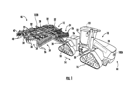
[0017] Referring now to the drawings, FIG. 1
illustrates a perspective view of one
embodiment of an agricultural machine in accordance with aspects of the
present
subject matter. As shown, in the illustrated embodiment, the agricultural
machine
corresponds to a work vehicle 10 and an associated agricultural implement 12.
In
general, the work vehicle 10 may be configured to tow the implement 12 across
a
4
CA 03145271 2022-1-21
WO 2021/021508
PCT/US2020/042982
field in a direction of travel (e.g., as indicated by arrow 14 in FIG. 1). As
such, in one
embodiment, the work vehicle 10 may be configured as an agricultural tractor
and the
implement 12 may be configured as a tillage implement. However, in other
embodiments, the work vehicle 10 may be configured as any other suitable type
of
vehicle, such as an agricultural harvester, a self-propelled sprayer, and/or
the like.
Similarly, the implement 12 may be configured as any other suitable type of
implement, such as a planter. Furthermore, it should be appreciated that the
agricultural machine may correspond to any suitable powered and/or unpowered
agricultural machine (including suitable vehicles and/or equipment, such as
only a
work vehicle or only an implement). Additionally, the agricultural machine may
include more than two machines (e.g., a tractor, a planter, and an associated
air cart)
coupled to a work vehicle.
[0018] As shown in FIG. 1, the work vehicle 10 may
include a pair of front track
assemblies 16, a pair or rear track assemblies 18, and a frame or chassis 20
coupled to
and supported by the track assemblies 16, 18. An operator's cab 22 may be
supported
by a portion of the chassis 20 and may house various input devices (e.g., a
user
interface) for permitting an operator to control the operation of one or more
components of the work vehicle 10 and/or one or more components of the
implement
12. Additionally, the work vehicle 10 may include an engine 24 and a
transmission
26 mounted on the chassis 20. The transmission 26 may be operably coupled to
the
engine 24 and may provide variably adjusted gear ratios for transferring
engine power
to the track assemblies 16, 18 via a drive axle assembly (not shown) (or via
axles if
multiple drive axles are employed).
[0019] Additionally, as shown in FIG. 1, the
implement 12 may generally include
a frame 28 configured to be towed by the vehicle 10 via a pull hitch or tow
bar 30 in
the direction of travel 14. In general, the frame 28 may include a plurality
of
structural frame members 32, such as beams, bars, and/or the like, configured
to
support or couple to a plurality of components. As such, the frame 28 may be
configured to support a plurality of ground-engaging tools, such as a
plurality of
shanks, disk blades, leveling blades, basket assemblies, tines, spikes, and/or
the like.
In one embodiment, the various ground-engaging tools may be configured to
perform
a tillage operation or any other suitable ground-engaging operation on the
field across
CA 03145271 2022-1-21
WO 2021/021508
PCT/US2020/042982
which the implement 12 is being towed. For example, in the illustrated
embodiment,
the frame 28 is configured to support various gangs 34 of disc blades 36, a
plurality of
ground-engaging shanks 38, a plurality of leveling blades 40, and a plurality
of
crumbler wheels or basket assemblies 42. However, in alternative embodiments,
the
frame 28 may be configured to support any other suitable ground-engaging
tool(s) or
combinations of ground-engaging tools.
[0020] Moreover, a location sensor 101 may be
provided in operative association
with the vehicle 10 and/or the implement 12. For instance, as shown in FIG. 1,
the
location sensor 101 is installed on or within the vehicle 10. However, in
other
embodiments, the location sensor 101 may be installed on or within the
implement 12.
In general, the location sensor 101 may be configured to determine the current
location of the vehicle 10 and/or the implement 12 using a satellite
navigation
positioning system (e.g. a CPS system, a Galileo positioning system, the
Global
Navigation satellite system (GLONASS), the BeiDou Satellite Navigation and
Positioning system, and/or the like). In such an embodiment, the location
determined
by the location sensor 101 may be transmitted to a controller(s) of the
vehicle 10
and/or the implement 12 (e.g., in the form coordinates) and stored within the
controller's memory for subsequent processing and/or analysis. For instance,
based
on the known dimensional configuration and/or relative positioning between the
vehicle 10 and the implement 12, the determined location from the location
sensor
101 may be used to geo-locate the implement 12 within the field.
[0021] In accordance with aspects of the present
subject matter, the
vehicle/implement 10/12 may include one or more radio detection and ranging
(RADAR) sensors coupled thereto and/or mounted thereon. As will be described
below, each RADAR sensor may be configured to capture RADAR data associated
with a portion of the field across which the vehicle/implement 10/12 is
traveling. The
captured RADAR data may, in turn, be indicative of one or more subsurface soil
layer
characteristics of the field. For example, such characteristics may include
the
presence and/or location of a subsurface soil compaction layer, the depth of a
seedbed, and/or the like. As such, in several embodiments, the RADAR sensor(s)
may be provided in operative association with the vehicle/implement 10/12 such
that
the sensor(s) has an associated field(s) of view or sensor detection range(s)
directed
6
CA 03145271 2022-1-21
WO 2021/021508
PCT/US2020/042982
towards a portion(s) of the field adjacent to the vehicle/implement 10/12. For
example, as shown in FIG. 1, in one embodiment, one RADAR sensor 102A may be
mounted on a forward end 44 of the work vehicle 10 to capture RADAR data
associated with a section of the field disposed in front of the vehicle 10
relative to the
direction of travel 14. Similarly, as shown in FIG. 1, a second RADAR sensor
102B
may be mounted on an aft end 46 of the implement 12 to capture RADAR data
associated with a section of the field disposed behind the implement 12
relative to the
direction of travel 14. However, in alternative embodiments, the RADAR sensors
102A, 102B may be installed at any other suitable location(s) on the
vehicle/implement 10/12. Additionally, in some embodiments, the
vehicle/implement
10/12 may include only one RADAR sensor or three or more RADAR sensors.
[0022] It should be further appreciated that the
configuration of the work vehicle
and the agricultural implement 12 described above and shown in FIG. 1 is
provided only to place the present subject matter in an exemplary field of
use. Thus,
it should be appreciated that the present subject matter may be readily
adaptable to
any manner of agricultural machine configuration.
[0023] Referring now to FIG. 2, a schematic view of
one embodiment of a system
100 for determining subsurface soil layer characteristics during the
performance of an
agricultural operation is illustrated in accordance with aspects of the
present subject
matter, In general, the system 100 will be described herein with reference to
the work
vehicle 10 and the agricultural implement 12 described above with reference to
FIG.
1. However, it should be appreciated by those of ordinary skill in the art
that the
disclosed system 100 may generally be utilized with agricultural machines
having any
other suitable machine configuration
[0024] As shown in FIG_ 2, the system 100 may
include one or more RADAR
sensor(s) 102 coupled to or otherwise mounted on the vehicle/implement 10/12.
Specifically, in several embodiments, as the vehicle/implement 10/12 travel
across the
field, the RADAR sensor(s) 102 may be configured to emit one or more radio
wave
and/or microwave output signals directed toward a portion of the field surface
within
the corresponding field of view or sensor detection zone. The output signal(s)
may, in
turn, be reflected by one or more subsurface soil layers (e.g., the compaction
layer) as
echo signal(s). Moreover, the RADAR sensor(s) 102 may be configured to receive
7
CA 03145271 2022-1-21
WO 2021/021508
PCT/US2020/042982
the reflected echo signal(s). In this regard, the time of flight, amplitude,
frequency,
and/or phase of the received echo signal(s) may be indicative of subsurface
soil layer
characteristic(s) of the field. As such, the RADAR sensor(s) 102 may
correspond to
any suitable type RADAR-based sensing device(s), such as a ground-penetrating
RADAR (GPR) sensor(s), a multiple-input-multiple-output (MIMO) radar
sensor(s), a
polarimetric radar sensor(s), and/or the like.
[0025] Additionally, the system 100 may include a
soil moisture sensor 104
coupled to or otherwise mounted on the vehicle/implement 10/12. In general,
the soil
moisture sensor 104 may be configured to capture data indicative of the soil
moisture
content of the field across which the vehicle/implement 10/12 is traveling.
For
example, in one embodiment, the soil moisture sensor 104 may be configured as
an
optical sensor configured to detect one or more characteristics of light
reflected by the
soil, with such characteristics generally being indicative of the soil
moisture content.
However, in alternative embodiments, the soil moisture sensor 104 may be
configured
as any other suitable device for sensing or detecting the soil moisture
content of the
field.
[0026] In accordance with aspects of the present
subject matter, the system 100
may include a controller 106 positioned on and/or within or otherwise
associated with
the vehicle 10 and/or the implement 12. In general, the controller 106 may
comprise
any suitable processor-based device known in the art, such as a computing
device or
any suitable combination of computing devices. Thus, in several embodiments,
the
controller 106 may include one or more processor(s) 108 and associated memory
device(s) 110 configured to perform a variety of computer-implemented
functions.
As used herein, the term "processor" refers not only to integrated circuits
referred to
in the art as being included in a computer, but also refers to a controller, a
microcontroller, a microcomputer, a programmable logic controller (PLC), an
application specific integrated circuit, and other programmable circuits.
Additionally,
the memory device(s) 110 of the controller 106 may generally comprise memory
element(s) including, but not limited to, a computer readable medium (e.g.,
random
access memory (RAM)), a computer readable non-volatile medium (e.g., a flash
memory), a floppy disc, a compact disc-read only memory (CD-ROM), a magneto-
optical disc (MOD), a digital versatile disc (DVD), and/or other suitable
memory
8
CA 03145271 2022-1-21
WO 2021/021508
PCT/US2020/042982
elements. Such memory device(s) 110 may generally be configured to store
suitable
computer-readable instructions that, when implemented by the processor(s) 108,
configure the controller 106 to perform various computer-implemented
functions.
[0027] In addition, the controller 106 may also
include various other suitable
components, such as a communications circuit or module, a network interface,
one or
more input/output channels, a data/control bus and/or the like, to allow
controller 106
to be communicatively coupled to any of the various other system components
described herein (e.g., the location sensor 101, the RADAR sensor(s) 102,
and/or the
soil moisture sensor 104). For instance, as shown in FIG. 2, a communicative
link or
interface 112 (e.g., a data bus) may be provided between the controller 106
and the
sensors 101, 102, 104 to allow the controller 106 to communicate with the
sensors
101, 102, 104 via any suitable communications protocol (e.g., CANBUS).
[0028] It should be appreciated that the controller
106 may correspond to an
existing controller(s) of the vehicle 10 and/or the implement 12, itself, or
the
controller 106 may correspond to a separate processing device. For instance,
in one
embodiment, the controller 106 may form all or part of a separate plug-in
module that
may be installed in association with the vehicle 10 and/or the implement 12 to
allow
for the disclosed systems to be implemented without requiring additional
software to
be uploaded onto existing control devices of the vehicle 10 andVor the
implement 12.
It should also be appreciated that the functions of the controller 106 may be
performed by a single processor-based device or may be distributed across any
number of processor-based devices, in which instance such devices may be
considered to form part of the controller 106. For instance, the functions of
the
controller 106 may be distributed across multiple application-specific
controllers,
such as an engine controller, a transmission controller, an implement
controller,
and/or the like.
[0029] Furthermore, in one embodiment, the system
100 may also include a user
interface 114. More specifically, the user interface 114 may be configured to
receive
inputs (e.g., inputs associated with the soil salinity and/or oxygen
content/porosity of
the field) from the operator of the vehicle/implement 10/12. As such, the user
interface 114 may include one or more input devices (not shown), such as
touchscreens, keypads, touchpads, knobs, buttons, sliders, switches, mice,
9
CA 03145271 2022-1-21
WO 2021/021508
PCT/US2020/042982
microphones, and/or the like, which are configured to receive the operator
inputs.
Furthermore, the user interface 114 may be communicatively coupled to the
controller
106 via the communicative link 112 to permit the received operator inputs to
be
transmitted from the user interface 114 to the controller 106. In addition,
some
embodiments of the user interface 114 may include one or more feedback devices
(not
shown), such as display screens, speakers, warning lights, and/or the like,
which are
configured to provide feedback from the controller 106 to the operator. In one
embodiment, the user interface 114 may be mounted or otherwise positioned
within
the cab 22 of the vehicle 10. However, in alternative embodiments, the user
interface
114 may mounted at any other suitable location.
[0030] Moreover, the system 100 may include a
remote database server 116
configured to store data associated with one or more previously captured or
determined secondary soil parameter(s) (e.g., the soil moisture content,
salinity,
and/or oxygen content/porosity) of the field across which the
vehicle/implement 10/12
is traveling. In general, the remote database server 116 may comprise any
suitable
processor-based device known in the art, such as a computing device or any
suitable
combination of computing devices. Thus, in several embodiments, the remote
database server 116 may include one or more processor(s) 118 and associated
memory device(s) 120 configured to perform a variety of computer-implemented
database server functions. Such memory device(s) 120 may generally be
configured
to store suitable computer-readable instructions that, when implemented by the
processor(s) 118, configure the remote database server 116 to perform various
computer-implemented database server functions.
[0031] Furthermore, the remote database server 116
may also include various
other suitable components, such as a communications circuit or module, a
network
interface, one or more input/output channels, a data/control bus and/or the
like, to
allow remote database server 116 to be communicatively coupled to the
controller
106. For instance, as shown in FIG. 2, a communicative link or interface 122
(e.g., a
data bus) may be provided between the remote database server 116 and the
controller
106 to allow the remote database server 116 and the controller 106 to
communicate
via any suitable communications protocol (e.g., Wi-Fi, 3G, 4G, LTE, and/or the
like).
CA 03145271 2022-1-21
WO 2021/021508
PCT/US2020/042982
[0032] Additionally, it should be appreciated that
the remote database server 116
may located at any suitable location that is remote or otherwise spaced apart
from the
vehicle 10 and the implement 12. For example, in one embodiment, the remote
database server 116 may be located at a farm management office or facility.
However, in alternative embodiments, the remote database server 116 may be
located
at any other suitable location.
[0033] In several embodiments, the controller 106
may be configured to receive
RADAR data from one or more RADAR sensors 102. As described above, the
vehicle/implement 10/12 may include one or more RADAR sensors 102, with each
RADAR sensor 102 configured to capture RADAR data of a portion of the field
within its field of view. In this regard, as the vehicle/implement 10/12
travels across
the field to perform an agricultural operation (e.g., a tillage operation)
thereon, the
controller 106 may be configured to receive RADAR data from the RADAR
sensor(s)
102 (e.g., via the communicative link 112). As will be described below, the
controller
106 may be configured to calibrate the received RADAR data and use the
calibrated
RADAR data to determine one or more subsurface soil characteristics (e.g., the
presence and/or location of a compaction layer and/or the seedbed depth) of
the field
across which the vehicle/implement 10/12 is traveling.
[0034] Furthermore, the controller 106 may be
configured to receive one or more
inputs associated with a secondary soil parameter(s) of the field. Such
secondary soil
parameter(s) may include the soil moisture content of the field, the soil
salinity of the
field, soil oxygen content or porosity of the field, and/or the like. As will
be
described below, the controller 106 may be configured to calibrate the
received
RADAR data based on the secondary soil parameter(s) such that the calibrated
RADAR data provides an accurate indication of the subsurface soil layer
characteristic(s).
[0035] In several embodiments, the controller 106
may be configured to receive
the input(s) associated with a secondary soil parameter(s) from a sensor(s)
provided in
operative association with the vehicle/implement 10/12. In general, certain
secondary
soil parameters, such as soil moisture content, may vary greatly across the
field. As
such, in one embodiment, the controller 106 may be configured to receive an
input(s)
11
CA 03145271 2022-1-21
WO 2021/021508
PCT/US2020/042982
associated with the soil moisture content of the field from a soil moisture
sensor 104.
More specifically, as described above, the vehicle/implement 10/12 may include
a soil
moisture sensor 104 configured to capture data indicative of the soil moisture
content
of the field. In this regard, as the vehicle/implement 10/12 travels across
the field, the
controller 106 may receive the sensor data from the soil moisture sensor 104
(e.g., via
the communicative link 112). Thereafter, the controller 106 may be configured
to
process/analyze the received sensor data to determine or estimate a soil
moisture
content value of the field at the current location of the vehicle/implement
10/12. For
instance, the controller 106 may include a look-up table(s), suitable
mathematical
formula, and/or algorithms stored within its memory device(s) 110 that
correlates the
received sensor data to the soil moisture content of the field. Additionally,
the
controller 106 may be configured to update the determined soil moisture
content value
at a predetermined rate (e.g., the sampling rate of the soil moisture sensor
104) based
on newly received sensor data as the vehicle/implement 10/12 is moved across
the
field. In this regard, each determined soil moisture content value may change
as the
soil moisture content of the field varies. However, in alternative
embodiments, the
controller 106 may be configured to receive an input(s) indicative of any
other
secondary soil parameter(s), such as the soil salinity and/or soil oxygen
content/porosity of the field, from one or more sensors provided in operative
association with the vehicle/implement 10/12.
[0036] Moreover, in several embodiments, the
controller 106 may be configured
to receive the input(s) associated with a secondary soil parameter(s) from an
operator
of the vehicle/implement 10/12. In general, certain secondary soil parameters,
such as
soil salinity and oxygen content/porosity, may vary little across the field
such that a
single value for such parameter(s) may be indicative of the entire field. As
such, in
one embodiment, the controller 106 may be configured to receive an input(s)
associated with the soil salinity and/or the soil oxygen content/porosity of
the field
from the operator of the vehicle/implement 10/12. More specifically, as
described
above, the vehicle/implement 10/12 may include a user interface 114 configured
to
receive operator inputs associated with the soil salinity and/or oxygen
content of the
field from the operator. As such, the vehicle/implement operator may determine
(e.g.,
by testing one or more soil samples from the field) the soil salinity and/or
oxygen
12
CA 03145271 2022-1-21
WO 2021/021508
PCT/US2020/042982
content/porosity for the field on which the agricultural operation is to be
performed.
The operator may then interact with the input device(s) of the user interface
114 to
provide the determined soil salinity and/or oxygen content/porosity values to
the user
interface 114. Thereafter, the soil salinity and/or oxygen content/porosity
values may
be transmitted from the user interface 114 to the controller 106 (e.g., via
the
communicative link 112). However, in alternative embodiments, the controller
106
may be configured to receive an input(s) indicative of any other secondary
soil
parameter(s), such as the soil moisture content of the field, from the
operator of the
vehicle/implement 10/12.
[0037] Furthermore, in several embodiments, the
secondary soil parameter(s) may
be geo-referenced to the current location of the vehicle/implement 10/12
within the
field. In such embodiments, the secondary soil parameter data stored in the
remote
database server 118 and/or the memory 110 of the controller 106 may be geo-
referenced to specific locations within the field. In this regard, as the
vehicle/implement 10/12 travels across the field, the controller 106 may be
configured
to geo-locate the vehicle/implement 10/12 within the field based on the data
(e.g.,
coordinates) received from the location sensor 101 (e.g., via the
communicative
link112). As such, the controller 106 may be configured to determine the
current
location the implement/vehicle 10/12 within the field based on the geo-located
position of the implement/vehicle 10/12. Thereafter, the controller 106 may be
configured to access the secondary soil characteristic data associated with
such
location of the field from its memory 110 and/or request such secondary soil
parameter data from the remote database server 116.
[0038] It should be appreciated that, in several
embodiments, the controller 106
may be configured to receive the input(s) associated with the secondary soil
parameter(s) from a combination of its memory 110, sensors, the operator of
the
vehicle/implement 10/12, and remote database servers/remote devices. For
example,
in one embodiment, the controller 106 may be configured to receive an input
associated with the soil moisture content of the field from the soil moisture
sensor 104
coupled to the vehicle/implement 10/12 and inputs associated with the soil
salinity
and the soil oxygen content/porosity from the operator (e.g., via the user
interface
114).
13
CA 03145271 2022-1-21
WO 2021/021508
PCT/US2020/042982
[0039] Additionally, it should be appreciated that
the controller 106 may be
configured to receive an input(s) associated with any suitable number of
secondary
soil parameters. For example, as indicated above, in one embodiment, the
controller
106 may be configured to receive inputs associated with three secondary soil
parameters (e.g., the soil moisture content, salinity, and oxygen
content/porosity) of
the field. However, in alternative embodiments, the controller 106 may be
configured
to receive inputs associated with a single secondary soil parameter (e.g., one
of the
soil moisture content, salinity, or oxygen content/porosity), two secondary
soil
parameters (e.g., two of the soil moisture content, salinity, or oxygen
content/porosity) or more than three secondary soil parameters (e.g., the soil
moisture
content, salinity, and oxygen content/porosity in addition to other
parameter(s)).
[0040] In general, variations in the soil
conditions across the field may impact the
accuracy of the subsurface soil layer characteristic determinations based on
the
received RADAR data, More specifically, moisture and salt may increase the
amount
that the soil absorbs or attenuates the output signal(s) emitted by the RADAR
sensor(s) 102. However, oxygen content/porosity may decrease the amount that
the
soil absorbs or attenuates the output signal(s) emitted by the RADAR sensor(s)
102.
As such, RADAR data captured in portion of the field having high soil moisture
content, high soil salinity, and/or low soil oxygen content/porosity may
indicate that
the compaction layer is shallower than it really is. Furthermore, such RADAR
data
may result in a determination that the seedbed floor is shallower than it
really is.
Conversely, RADAR data captured in portion of the field having low soil
moisture
content, low soil salinity, and/or high soil oxygen content/porosity may
result in a
determination that the compaction layer is deeper than it really is.
Furthermore, such
RADAR data may result in a determination that the seedbed floor is deeper than
it
really is.
[0041] In accordance with aspects of the present
subject matter, the controller 106
may be configured to calibrate the received RADAR data based on the secondary
soil
parameter(s). In general, the controller 106 may be configured to adjust or
otherwise
modify the received RADAR based on the secondary soil parameter(s) such that
the
calibrated RADAR data provides an accurate indication of the subsurface soil
layer
characteristic(s) of the soil. Specifically, in several embodiments, the
controller 106
14
CA 03145271 2022-1-21
WO 2021/021508
PCT/US2020/042982
may be configured to determine one or more correction factor(s) for the RADAR
data
based on the secondary soil parameter(s). Thereafter, the controller 106 may
be
configured to adjust the one or more parameters of the received RADAR data
based
on the determined correction factor(s) to calibrate the RADAR data. Such
parameters
may include the time of flight, amplitude, frequency, and/or phase of the
received
echo signal(s) associated with the received RADAR data For example, in one
embodiment, the determined correction factor(s) may correspond to a single
numerical value(s) that is mathematically combined with (e.g., multiplied by)
the
value(s) associated with the parameter(s) of the received RADAR data
Additionally,
in some embodiments, a correction factor may be determined for each parameter
associated with the received RADAR data that is used in determining the
subsurface
soil layer characteristic(s).
[0042] It should be appreciated that the controller
106 may be configured to
determine the correction factor(s) for the received RADAR data in any suitable
marmer. As indicated above, in several embodiments, each correction factor may
correspond to a single numerical value. For example, in such embodiments, the
controller 106 may be configured to access one or more look-up tables stored
within
its memory device(s) 110. Each look-up table may, in turn, provide a
correction
factor value associated with a corresponding secondary soil parameter value or
combination of secondary soil parameter values. In another embodiment, the
controller 106 may be configured to calculate the correction factor(s) from
the
secondary soil parameter(s) using one or more mathematical formula stored
within its
memory device(s) 110. However, in alternative embodiments, the controller 106
may
be configured to calibrate the received RADAR data in a more complex manner.
For
instance, the controller 106 may calibrate the received RADAR data using one
or
more suitable algorithms that modify the RADAR data in a more complex manner,
such as by modifying the shape(s) of the echo signal(s) associated with the
such data,
based on the secondary soil parameter(s).
[0043] Furthermore, the controller 106 may be
configured to determine one or
more subsurface soil layer characteristics based on the calibrated RADAR data.
Such
subsurface soil layer characteristics may include the presence of a subsurface
soil
compaction layer, the location/depth of the compaction layer, the depth of a
seedbed
CA 03145271 2022-1-21
WO 2021/021508
PCT/US2020/042982
floor, and/or the like. In general, as described above, the calibrated RADAR
data may
provide an accurate indication of the subsurface soil layer characteristics(s)
of the
field by taking into account the soil conditions of the field. As such, the
controller
106 may be configured to process/analyze the calibrated RADAR data to
determine or
estimate the subsurface soil layer characteristic(s) of the field at the
current location
of the vehicle/implement 10/12. For instance, the controller 106 may include a
look-
up table(s), suitable mathematical formula, and/or algorithms stored within
its
memory device(s) 110 that correlates the calibrated RADAR data to the
subsurface
soil layer characteristic(s) of the field.
[0044] Referring now to FIG. 3, a flow diagram of
one embodiment of a method
200 for determining subsurface soil layer characteristics during the
performance of an
agricultural operation is illustrated in accordance with aspects of the
present subject
matter. In general, the method 200 will be described herein with reference to
the
work vehicle 10, the agricultural implement 12, and the system 100 described
above
with reference to FIGS_ 1 and 2. However, it should be appreciated by those of
ordinary skill in the art that the disclosed method 200 may generally be
implemented
with any agricultural machines having any suitable machine configuration
and/or any
system having any suitable system configuration. In addition, although FIG. 3
depicts
steps performed in a particular order for purposes of illustration and
discussion, the
methods discussed herein are not limited to any particular order or
arrangement. One
skilled in the art, using the disclosures provided herein, will appreciate
that various
steps of the methods disclosed herein can be omitted, rearranged, combined,
and/or
adapted in various ways without deviating from the scope of the present
disclosure.
[0045] As shown in FIG. 3, at (202), the method 200
may include receiving, with
one or more computing devices, RADAR data indicative of a subsurface soil
layer
characteristic of a field on which an agricultural operation is being
performed. For
instance, as described above, as a work vehicle 10 or an agricultural
implement 12
performs an agricultural operation on a field, the controller 106 may be
configured to
receive RADAR data from one or more RADAR sensors 102 coupled to or mounted
on the vehicle/implement 10/12. The RADAR data may, in turn, be indicative of
one
or more subsurface soil layer characteristics of field, such as the presence
of a
16
CA 03145271 2022-1-21
WO 2021/021508
PCT/US2020/042982
compaction layer, the location/depth of the compaction, depth of the seedbed,
and/or
the like.
[0046] Additionally, at (204), the method 200 may
include receiving, with the one
or more computing devices, an input associated with a secondary soil parameter
of the
field. For instance, as described above, the controller 106 may be configured
to
receive one or more inputs from an operator (e.g., via the user interface 114)
and/or a
sensor (e.g., the soil moistures sensor 104) of the vehicle/implement 10/12.
Such
input(s) may, in turn, be indicative of one or more secondary soil parameters,
such as
the soil moisture content, salinity and/or oxygen content/porosity of the
field.
[0047] Moreover, as shown in FIG. 3, at (206), the
method 200 may include
calibrating, with the one or more computing devices, the received RADAR data
based
on the secondary soil parameter. For instance, as described above, the
controller 106
may be configured to calibrate the received RADAR data based on the received
secondary soil characteristic(s).
[0048] Furthermore, at (208), the method 200 may
include determining, with the
one or more computing devices, the subsurface soil layer characteristic based
on the
calibrated RADAR data. For instance, as described above, the controller 106
may be
configured to determine the subsurface soil layer characteristic(s) based on
the
calibrated RADAR data
[0049] It is to be understood that the steps of the
method 200 are performed by the
controller 106 upon loading and executing software code or instructions which
are
tangibly stored on a tangible computer readable medium, such as on a magnetic
medium, e.g., a computer hard drive, an optical medium, e.g., an optical disc,
solid-
state memory, e.g., flash memory, or other storage media known in the art.
Thus, any
of the functionality performed by the controller 106 described herein, such as
the
method 200, is implemented in software code or instructions which are tangibly
stored on a tangible computer readable medium. The controller 106 loads the
software code or instructions via a direct interface with the computer
readable
medium or via a wired and/or wireless network. Upon loading and executing such
software code or instructions by the controller 106, the controller 106 may
perform
any of the functionality of the controller 106 described herein, including any
steps of
the method 200 described herein.
17
CA 03145271 2022-1-21
WO 2021/021508
PCT/US2020/042982
[0050] The term "software code" or "code" used
herein refers to any instructions
or set of instructions that influence the operation of a computer or
controller. They
may exist in a computer-executable form, such as machine code, which is the
set of
instructions and data directly executed by a computer's central processing
unit or by a
controller, a human-understandable form, such as source code, which may be
compiled in order to be executed by a computer's central processing unit or by
a
controller, or an intermediate form, such as object code, which is produced by
a
compiler. As used herein, the term "software code" or "code" also includes any
human-understandable computer instructions or set of instructions, e.g., a
script, that
may be executed on the fly with the aid of an interpreter executed by a
computer's
central processing unit or by a controller.
[00511 This written description uses examples to
disclose the technology,
including the best mode, and also to enable any person skilled in the art to
practice the
technology, including making and using any devices or systems and performing
any
incorporated methods. The patentable scope of the technology is defined by the
claims, and may include other examples that occur to those skilled in the art.
Such
other examples are intended to be within the scope of the claims if they
include
structural elements that do not differ from the literal language of the
claims, or if they
include equivalent structural elements with insubstantial differences from the
literal
language of the claims.
18
CA 03145271 2022-1-21