Note: Descriptions are shown in the official language in which they were submitted.
CA 03145740 2021-12-30
WO 2021/003440 PCT/US2020/040768
BEAM STEERING RADAR WITH SELECTIVE SCANNING MODE FOR
AUTONOMOUS VEHICLES
CROSS REFERENCE TO RELATED APPLICATIONS
[0001] This application claims priority to U.S. Prov. App!. No. 62/869,913,
titled "BEAM
STEERING RADAR WITH A SELECTIVE SCANNING MODE FOR USE IN
AUTONOMOUS VEHICLES," filed on July 2, 2019, which is incorporated by
reference herein
in its entirety.
BACKGROUND
[0002] Autonomous driving is quickly moving from the realm of science
fiction to
becoming an achievable reality. Already in the market are Advanced-Driver
Assistance Systems
("ADAS") that automate, adapt and enhance vehicles for safety and better
driving. The next
step will be vehicles that increasingly assume control of driving functions
such as steering,
accelerating, braking and monitoring the surrounding environment and driving
conditions to
respond to events, such as changing lanes or speed when needed to avoid
traffic, crossing
pedestrians, animals, and so on. The requirements for object and image
detection are critical
and specify the time required to capture data, process it and turn it into
action. All this while
ensuring accuracy, consistency and cost optimization.
[0003] An aspect of making this work is the ability to detect and classify
objects in the
surrounding environment at the same or possibly even better level as humans.
Humans are
adept at recognizing and perceiving the world around them with an extremely
complex human
visual system that essentially has two main functional parts: the eye and the
brain. In
autonomous driving technologies, the eye may include a combination of multiple
sensors, such
as camera, radar, and lidar, while the brain may involve multiple artificial
intelligence, machine
learning and deep learning systems. The goal is to have full understanding of
a dynamic, fast-
moving environment in real time and human-like intelligence to act in response
to changes in
the environment.
BRIEF DESCRIPTION OF THE DRAWINGS
[0004] The present application may be more fully appreciated in connection
with the
following detailed description taken in conjunction with the accompanying
drawings, which are
-1-
CA 03145740 2021-12-30
WO 2021/003440 PCT/US2020/040768
not drawn to scale and in which like reference characters refer to like parts
throughout, and
wherein:
[0005] FIG. 1 illustrates an example environment in which a beam steering
radar with a
selective scanning mode in an autonomous vehicle is used to detect and
identify objects;
[0006] FIG. 2 is a schematic diagram of an autonomous driving system for an
autonomous
vehicle in accordance with various examples;
[0007] FIG. 3 is a schematic diagram of a beam steering radar system as in
FIG. 2 in
accordance with various examples;
[0008] FIG. 4 illustrates an example environment in which a beam steering
radar
implemented as in FIG. 3 operates in a selective scanning mode;
[0009] FIG. 5 illustrates the antenna elements of the receive and guard
antennas of FIG. 3
in more detail in accordance with various examples;
[0010] FIG. 6 illustrates an example radar signal and its associated scan
parameters in
more detail;
[0011] FIG. 7 is a flowchart of an example process for operating a beam
steering radar in
an adjustable long-range mode in accordance with various examples; and
[0012] FIG. 8 illustrates an example radar beam transmitted by a beam
steering radar
implemented as in FIG. 3 and in accordance with various examples.
DETAILED DESCRIPTION
[0013] A beam steering radar with a selective scanning mode for use in
autonomous
vehicles is disclosed. The beam steering radar incorporates at least one beam
steering antenna
that is dynamically controlled such as to change its electrical or
electromagnetic configuration
to enable beam steering. The beam steering antenna generates a narrow,
directed beam that can
be steered to any angle (i.e., from 00 to 3600) across a field-of-view ("FoV")
to detect objects.
In various examples, the beam steering radar operates in a selective scanning
mode to scan
around an area of interest. The beam steering radar can steer to a desired
angle and then scan
around that angle to detect objects in the area of interest without wasting
any processing or
scanning cycles illuminating areas with no valid objects. The dynamic control
is implemented
with processing engines which upon identifying objects in the vehicle's FoV,
inform the beam
steering radar where to steer its beams and focus on the areas and objects of
interest by adjusting
its radar scan parameters. The objects of interest may include structural
elements in the
-2-
CA 03145740 2021-12-30
WO 2021/003440 PCT/US2020/040768
vehicle's FoV such as roads, walls, buildings and road center medians, as well
as other vehicles,
pedestrians, bystanders, cyclists, plants, trees, animals and so on.
[0014] The detailed description set forth below is intended as a
description of various
configurations of the subject technology and is not intended to represent the
only configurations
in which the subject technology may be practiced. The appended drawings are
incorporated
herein and constitute a part of the detailed description. The detailed
description includes
specific details for the purpose of providing a thorough understanding of the
subject
technology. However, the subject technology is not limited to the specific
details set forth
herein and may be practiced using one or more implementations. In one or more
instances,
structures and components are shown in block diagram form in order to avoid
obscuring the
concepts of the subject technology. In other instances, well-known methods and
structures may
not be described in detail to avoid unnecessarily obscuring the description of
the examples.
Also, the examples may be used in combination with each other.
[0015] FIG. 1 illustrates an example environment in which a beam steering
radar with a
selective scanning mode in an autonomous vehicle is used to detect and
identify objects. Ego
vehicle 100 is an autonomous vehicle with a beam steering radar system 106 for
transmitting a
radar signal to scan a FoV or specific area. As described in more detail
below, the radar signal
is transmitted according to a set of scan parameters that can be adjusted to
result in multiple
transmission beams 118. The scan parameters may include, among others, the
total angle of the
scanned area defining the FoV, the beam width or the scan angle of each
incremental
transmission beam, the number of chirps in the radar signal, the chirp time,
the chirp segment
time, the chirp slope, and so on. The entire FoV or a portion of it can be
scanned by a
compilation of such transmission beams 118, which may be in successive
adjacent scan
positions or in a specific or random order. Note that the term FoV is used
herein in reference
to the radar transmissions and does not imply an optical FoV with unobstructed
views. The
scan parameters may also indicate the time interval between these incremental
transmission
beams, as well as start and stop angle positions for a full or partial scan.
[0016] In various examples, the ego vehicle 100 may also have other
perception sensors
such as camera 102 and lidar 104. These perception sensors are not required
for the ego vehicle
100, but may be useful in augmenting the object detection capabilities of the
beam steering
radar 106. Camera sensor 102 may be used to detect visible objects and
conditions and to assist
in the performance of various functions. The lidar sensor 104 can also be used
to detect objects
and provide this information to adjust control of the vehicle. This
information may include
-3-
CA 03145740 2021-12-30
WO 2021/003440 PCT/US2020/040768
information such as congestion on a highway, road conditions, and other
conditions that would
impact the sensors, actions or operations of the vehicle. Camera sensors are
currently used in
Advanced Driver Assistance Systems ("ADAS") to assist drivers in driving
functions such as
parking (e.g., in rear view cameras). Cameras can capture texture, color and
contrast
information at a high level of detail, but similar to the human eye, they are
susceptible to
adverse weather conditions and variations in lighting. Camera 102 may have a
high resolution
but cannot resolve objects beyond 50 meters.
[0017] Lidar sensors typically measure the distance to an object by
calculating the time
taken by a pulse of light to travel to an object and back to the sensor. When
positioned on top
of a vehicle, a lidar sensor can provide a 3600 3D view of the surrounding
environment. Other
approaches may use several lidars at different locations around the vehicle to
provide the full
360 view. However, lidar sensors such as lidar 104 are still prohibitively
expensive, bulky in
size, sensitive to weather conditions and are limited to short ranges
(typically < 150-200
meters). Radars, on the other hand, have been used in vehicles for many years
and operate in
all-weather conditions. Radars also use far less processing than the other
types of sensors and
have the advantage of detecting objects behind obstacles and determining the
speed of moving
objects. When it comes to resolution, lidars' laser beams are focused on small
areas, have a
smaller wavelength than RF signals, and can achieve around 0.25 degrees of
resolution.
[0018] In various examples and as described in more detail below, the beam
steering radar
106 can provide a 360 true 3D vision and human-like interpretation of the ego
vehicle's path
and surrounding environment. The beam steering radar 106 is capable of shaping
and steering
RF beams in all directions in a 360 FoV with at least one beam steering
antenna and
recognize objects quickly and with a high degree of accuracy over a long range
of around 300
meters or more. The short-range capabilities of camera 102 and lidar 104 along
with the long-
range capabilities of radar 106 enable a sensor fusion module 108 in ego
vehicle 100 to
enhance its object detection and identification.
[0019] As illustrated, beam steering radar 106 is capable of detecting both
vehicle 120 at a
far range (e.g., >250 m) as well as bus 122 at a short range (e.g., < 100 m).
Detecting both in a
short amount of time and with enough range and velocity resolution is
imperative for full
autonomy of driving functions of the ego vehicle. Radar 106 has an adjustable
long-range
radar ("LRIt") mode that enables the detection of long-range objects in a very
short time to
then focus on obtaining finer velocity resolution for the detected vehicles.
Although not
described herein, radar 106 is capable of time-alternatively reconfiguring
between LRR and
-4-
CA 03145740 2021-12-30
WO 2021/003440 PCT/US2020/040768
short-range radar ("SRR") modes. The SRR mode enables a wide beam with lower
gain, but can
make quick decisions to avoid an accident, assist in parking and downtown
travel, and capture
information about a broad area of the environment. The LRR mode enables a
narrow, directed
beam and long distance, having high gain; this is powerful for high speed
applications, and
where longer processing time allows for greater reliability. The adjustable
LRR mode uses a
reduced number of chirps (e.g., 5, 10, 15, or 20) to reduce the chirp segment
time by up to 75%,
guaranteeing a fast beam scanning rate that is critical for successful object
detection and
autonomous vehicle performance. Excessive dwell time for each beam position
may cause
blind zones, and the adjustable LRR mode ensures that fast object detection
can occur at long
range while maintaining the antenna gain, transmit power and desired SNR for
the radar
operation.
[0020] Attention is now directed to FIG. 2, which illustrates a schematic
diagram of an
autonomous driving system for an ego vehicle in accordance with various
examples.
Autonomous driving system 200 is a system for use in an ego vehicle that
provides some or full
automation of driving functions. The driving functions may include, for
example, steering,
accelerating, braking, and monitoring the surrounding environment and driving
conditions to
respond to events, such as changing lanes or speed when needed to avoid
traffic, crossing
pedestrians, animals, and so on. The autonomous driving system 200 includes a
beam steering
radar system 202 and other sensor systems such as camera 204, lidar 206,
infrastructure sensors
208, environmental sensors 210, operational sensors 212, user preference
sensors 214, and other
sensors 216. Autonomous driving system 200 also includes a communications
module 218, a
sensor fusion module 220, a system controller 222, a system memory 224, and a
vehicle-to-
vehicle (V2V) communications module 226. It is appreciated that this
configuration of
autonomous driving system 200 is an example configuration and not meant to be
limiting to the
specific structure illustrated in FIG. 2. Additional systems and modules not
shown in FIG. 2
may be included in autonomous driving system 200.
[0021] In various examples, beam steering radar 202 with adjustable LRR
mode includes at
least one beam steering antenna for providing dynamically controllable and
steerable beams that
can focus on one or multiple portions of a 360 FoV of the vehicle. The beams
radiated from the
beam steering antenna are reflected back from objects in the vehicle's path
and surrounding
environment and received and processed by the radar 202 to detect and identify
the objects.
Radar 202 includes a perception module that is trained to detect and identify
objects and control
the radar module as desired. Camera sensor 204 and lidar 206 may also be used
to identify
-5-
CA 03145740 2021-12-30
WO 2021/003440 PCT/US2020/040768
objects in the path and surrounding environment of the ego vehicle, albeit at
a much lower
range.
[0022] Infrastructure sensors 208 may provide information from
infrastructure while
driving, such as from a smart road configuration, bill board information,
traffic alerts and
indicators, including traffic lights, stop signs, traffic warnings, and so
forth. This is a growing
area, and the uses and capabilities derived from this information are immense.
Environmental
sensors 210 detect various conditions outside, such as temperature, humidity,
fog, visibility,
precipitation, among others. Operational sensors 212 provide information about
the functional
operation of the vehicle. This may be tire pressure, fuel levels, brake wear,
and so forth. The
user preference sensors 214 may be configured to detect conditions that are
part of a user
preference. This may be temperature adjustments, smart window shading, etc.
Other sensors
216 may include additional sensors for monitoring conditions in and around the
vehicle.
[0023] In various examples, the sensor fusion module 220 optimizes these
various functions
to provide an approximately comprehensive view of the vehicle and
environments. Many types
of sensors may be controlled by the sensor fusion module 220. These sensors
may coordinate
with each other to share information and consider the impact of one control
action on another
system. In one example, in a congested driving condition, a noise detection
module (not shown)
may identify that there are multiple radar signals that may interfere with the
vehicle. This
information may be used by a perception module in radar 202 to adjust the
radar's scan
parameters so as to avoid these other signals and minimize interference.
[0024] In another example, environmental sensor 210 may detect that the
weather is
changing, and visibility is decreasing. In this situation, the sensor fusion
module 220 may
determine to configure the other sensors to improve the ability of the vehicle
to navigate in
these new conditions. The configuration may include turning off camera or
lidar sensors 204-
206 or reducing the sampling rate of these visibility-based sensors. This
effectively places
reliance on the sensor(s) adapted for the current situation. In response, the
perception module
configures the radar 202 for these conditions as well. For example, the radar
202 may reduce
the beam width to provide a more focused beam, and thus a finer sensing
capability.
[0025] In various examples, the sensor fusion module 220 may send a direct
control to radar
202 based on historical conditions and controls. The sensor fusion module 220
may also use
some of the sensors within system 200 to act as feedback or calibration for
the other sensors. In
this way, an operational sensor 212 may provide feedback to the perception
module and/or the
sensor fusion module 220 to create templates, patterns and control scenarios.
These are based
-6-
CA 03145740 2021-12-30
WO 2021/003440 PCT/US2020/040768
on successful actions or may be based on poor results, where the sensor fusion
module 220
learns from past actions.
[0026] Data from sensors 202-216 may be combined in sensor fusion module
220 to
improve the target detection and identification performance of autonomous
driving system 200.
Sensor fusion module 220 may itself be controlled by system controller 222,
which may also
interact with and control other modules and systems in the vehicle. For
example, system
controller 222 may turn the different sensors 202-216 on and off as desired,
or provide
instructions to the vehicle to stop upon identifying a driving hazard (e.g.,
deer, pedestrian,
cyclist, or another vehicle suddenly appearing in the vehicle's path, flying
debris, etc.).
[0027] All modules and systems in autonomous driving system 200 communicate
with
each other through communication module 218. Autonomous driving system 200
also includes
system memory 224, which may store information and data (e.g., static and
dynamic data) used
for operation of system 200 and the ego vehicle using system 200. V2V
communications
module 226 is used for communication with other vehicles. The V2V
communications may
also include information from other vehicles that is invisible to the user,
driver, or rider of the
vehicle, and may help vehicles coordinate to avoid an accident. Mapping unit
228 may provide
mapping and location data for the vehicle, which alternatively may be stored
in system memory
224. In various examples, the mapping and location data may be used in a
selective scanning
mode of operation of beam steering radar 202 to focus the beam steering around
an angle of
interest when the ego vehicle is navigating a curved road. In other examples,
the mapping and
location data may be used in the selective scanning mode of operation of beam
steering radar
202 to focus the beam steering for a reduced range with higher range
resolution (albeit with a
smaller maximum velocity) in a city street environment or focus the beam
steering for an
increased range with higher maximum velocity (albeit with a larger range
resolution) in a
highway environment.
[0028] FIG. 3 illustrates a schematic diagram of a beam steering radar
system with a
selective scanning mode as in FIG. 2 in accordance with various examples. Beam
steering radar
300 is a "digital eye" with true 3D vision and capable of a human-like
interpretation of the
world. The "digital eye" and human-like interpretation capabilities are
provided by two main
modules: radar module 302 and a perception engine 304. Radar module 302 is
capable of both
transmitting RF signals within a FoV and receiving the reflections of the
transmitted signals as
they reflect off of objects in the FoV. With the use of analog beamforming in
radar module
302, a single transmit and receive chain can be used effectively to form a
directional, as well
as a steerable, beam. A transceiver 306 in radar module 302 is adapted to
generate signals for
-7-
CA 03145740 2021-12-30
WO 2021/003440 PCT/US2020/040768
transmission through a series of transmit antennas 308 as well as manage
signals received
through a series of receive antennas 310-314. Beam steering within the FoV is
implemented
with phase shifter ("PS") circuits 316-318 coupled to the transmit antennas
308 on the transmit
chain and PS circuits 320-324 coupled to the receive antennas 310-314 on the
receive chain,
respectively.
[0029] The use of PS circuits 316-318 and 320-324 enables separate control
of the phase
of each element in the transmit and receive antennas. Unlike early passive
architectures, the
beam is steerable not only to discrete angles but to any angle (i.e., from 00
to 360 ) within the
FoV using active beamforming antennas. A multiple element antenna can be used
with an
analog beamforming architecture where the individual antenna elements may be
combined or
divided at the port of the single transmit or receive chain without additional
hardware
components or individual digital processing for each antenna element. Further,
the flexibility
of multiple element antennas allows narrow beam width for transmit and
receive. The antenna
beam width decreases with an increase in the number of antenna elements. A
narrow beam
improves the directivity of the antenna and provides the radar 300 with a
significantly longer
detection range.
[0030] The major challenge with implementing analog beam steering is to
design PSs to
operate at 77GHz. PS circuits 316-318 and 320-324 solve this problem with a
reflective PS
design implemented with a distributed varactor network currently built using
Gallium-
Arsenide (GaAs) materials. Each PS circuit 316-318 and 320-324 has a series of
PSs, with
each PS coupled to an antenna element to generate a phase shift value of
anywhere from 00 to
3600 for signals transmitted or received by the antenna element. The PS design
is scalable in
future implementations to Silicon-Germanium (SiGe) and complementary metal-
oxide
semiconductors (CMOS), bringing down the PS cost to meet specific demands of
customer
applications. Each PS circuit 316-318 and 320-324 is controlled by a Field
Programmable
Gate Array ("FPGA") 326, which provides a series of voltages to the PSs in
each PS circuit
that results in a series of phase shifts.
[0031] In various examples, a voltage value is applied to each PS in the PS
circuits 316-
318 and 320-324 to generate a given phase shift and provide beam steering. The
voltages
applied to the PSs in PS circuits 316-318 and 320-324 are stored in Look-up
Tables ("LUTs")
in the FPGA 306. These LUTs are generated by an antenna calibration process
that determines
which voltages to apply to each PS to generate a given phase shift under each
operating
condition. Note that the PSs in PS circuits 316-318 and 320-324 are capable of
generating phase
-8-
CA 03145740 2021-12-30
WO 2021/003440 PCT/US2020/040768
shifts at a very high resolution of less than one degree. This enhanced
control over the phase
allows the transmit and receive antennas in radar module 302 to steer beams
with a very small
step size, improving the capability of the radar 300 to resolve closely
located targets at small
angular resolution.
[0032] In various examples, the transmit antennas 308 and the receive
antennas 310-314
may be a meta-structure antenna, a phase array antenna, or any other antenna
capable of
radiating RF signals in millimeter wave frequencies. A meta-structure, as
generally defined
herein, is an engineered structure capable of controlling and manipulating
incident radiation at
a desired direction based on its geometry. Various configurations, shapes,
designs and
dimensions of the antennas 308-3 14 may be used to implement specific designs
and meet
specific constraints.
[0033] The transmit chain in radar 300 starts with the transceiver 306
generating RF
signals to prepare for transmission over-the-air by the transmit antennas 308.
The RF signals
may be, for example, Frequency-Modulated Continuous Wave ("FMCW") signals. An
FMCW
signal enables the radar 300 to determine both the range to an object and the
object's velocity
by measuring the differences in phase or frequency between the transmitted
signals and the
received/reflected signals or echoes. Within FMCW formats, there are a variety
of waveform
patterns that may be used, including sinusoidal, triangular, sawtooth,
rectangular and so forth,
each having advantages and purposes.
[0034] Once the FMCW signals are generated by the transceiver 306, they are
provided to
power amplifiers ("PAs") 328-33 2. Signal amplification is needed for the FMCW
signals to
reach the long ranges desired for object detection, as the signals attenuate
as they radiate by the
transmit antennas 308. From the PAs 328-332, the signals are divided and
distributed through
feed networks 334-336, which form a power divider system to divide an input
signal into
multiple signals, one for each element of the transmit antennas 308. The feed
networks 334-
336 may divide the signals so power is equally distributed among them, or
alternatively, so
power is distributed according to another scheme, in which the divided signals
do not all receive
the same power. Each signal from the feed networks 334-336 is then input into
a PS in PS
circuits 3 16-318, where they are phase shifted based on voltages generated by
the FPGA 326
under the direction of microcontroller 338 and then transmitted through
transmit antennas 308.
[0035] Microcontroller 338 determines which phase shifts to apply to the P
Ss in PS circuits
316-318 according to a desired scanning mode based on road and environmental
scenarios.
Microcontroller 338 also determines the scan parameters for the transceiver to
apply at its next
-9-
CA 03145740 2021-12-30
WO 2021/003440 PCT/US2020/040768
scan. The scan parameters may be determined at the direction of one of the
processing engines
350, such as at the direction of perception engine 304. Depending on the
objects detected, the
perception engine 304 may instruct the microcontroller 338 to adjust the scan
parameters at a
next scan to focus on a given area of the FoV or to steer the beams to a
different direction.
[0036] In various examples and as described in more detail below, radar 300
operates in
one of various modes, including a full scanning mode and a selective scanning
mode, among
others. In a full scanning mode, both transmit antennas 308 and receive
antennas 310-3 14 scan
a complete FoV with small incremental steps. Even though the FoV may be
limited by system
parameters due to increased side lobes as a function of the steering angle,
radar 300 can detect
objects over a significant area for a long- range radar. The range of angles
to be scanned on
either side of boresight as well as the step size between steering
angles/phase shifts can be
dynamically varied based on the driving environment. To improve performance of
an
autonomous vehicle (e.g., an ego vehicle) driving through an urban
environment, the scan range
can be increased to keep monitoring the intersections and curbs to detect
vehicles, pedestrians
or bicyclists. This wide scan range may deteriorate the frame rate (revisit
rate), but is
considered acceptable as the urban environment generally involves low velocity
driving
scenarios. For a high-speed freeway scenario, where the frame rate is
critical, a higher frame
rate can be maintained by reducing the scan range. In this case, a few degrees
of beam scanning
on either side of the boresight would suffice for long-range target detection
and tracking.
[0037] In a selective scanning mode, the radar 300 scans around an area of
interest by
steering to a desired angle and then scanning around that angle. This ensures
the radar 300 is
to detect objects in the area of interest without wasting any processing or
scanning cycles
illuminating areas with no valid objects. One of the scenarios in which such
scanning is useful
is in the case of a curved freeway or road as illustrated in FIG. 4. Since the
radar 300 can detect
objects at a long distance, e.g., 300 m or more at boresight, if there is a
curve in a road such as
road 400, direct measures do not provide helpful information. Rather, the
radar 300 steers
along the curvature of the road, as illustrated with beam area 402. The radar
300 may acquire
mapping and location data from a database or mapping unit in the vehicle
(e.g., mapping unit
228 of FIG. 2) to know when a curved road will appear so the radar 300 can
activate the
selective scanning mode. Similarly in other use cases, the mapping and
location data can be
used to detect a change in the path and/or surrounding environment, such as a
city street
environment or a highway environment, where the maximum range needed for
object
detection may vary depending on the detected environment (or path). For
example, the
mapping and location data may be used in the selective scanning mode of
operation of radar
CA 03145740 2021-12-30
WO 2021/003440 PCT/US2020/040768
300 to focus the beam steering for a reduced range with higher range
resolution (albeit with a
smaller maximum velocity) in a city street environment or focus the beam
steering for an
increased range with higher maximum velocity (albeit with a larger range
resolution) in a
highway environment.
[0038] This selective scanning mode is more efficient, as it allows the
radar 300 to align
its beams towards the area of interest rather than waste any scanning on areas
without objects
or useful information to the vehicle. In various examples, the selective
scanning mode is
implemented by changing the chirp slope of the FMCW signals generated by the
transceiver
306 and by shifting the phase of the transmitted signals to the steering
angles needed to cover
the curvature of the road 400.
[0039] Returning to FIG. 3, objects are detected with radar 300 by
reflections or echoes
that are received at the series of receive antennas 310-314, which are
directed by PS circuits
320-324. Low Noise Amplifiers ("LNAs) are positioned between receive antennas
310-314
and PS circuits 320-324, which include PSs similar to the PSs in PS circuits
316-3 18. For
receive operation, PS circuits 310-324 create phase differentials between
radiating elements in
the receive antennas 310-314 to compensate for the time delay of received
signals between
radiating elements due to spatial configurations. Receive phase-shifting, also
referred to as
analog beamforming, combines the received signals for aligning echoes to
identify the location,
or position of a detected object. That is, phase shifting aligns the received
signals that arrive at
different times at each of the radiating elements in receive antennas 310-314.
Similar to PS
circuits 3 16-318 on the transmit chain, PS circuits 320-324 are controlled by
FPGA 326, which
provides the voltages to each PS to generate the desired phase shift. FPGA 326
also provides
bias voltages to the LNAs 338-342.
[0040] The receive chain then combines the signals received at receive
antennas 312 at
combination network 344, from which the combined signals propagate to the
transceiver 306.
Note that as illustrated, combination network 344 generates two combined
signals 346-348,
with each signal combining signals from a number of elements in the receive
antennas 312. In
one example, receive antennas 312 include 48 radiating elements and each
combined signal
346-348 combines signals received by 24 of the 48 elements. Other examples may
include 8,
16, 24, 32, and so on, depending on the desired configuration. The higher the
number of antenna
elements, the narrower the beam width.
[0041] Note also that the signals received at receive antennas 310 and 314
go directly from
PS circuits 320 and 324 to the transceiver 306. Receive antennas 310 and 314
are guard
-11-
CA 03145740 2021-12-30
WO 2021/003440 PCT/US2020/040768
antennas that generate a radiation pattern separate from the main beams
received by the 48-
element receive antenna 312. Guard antennas 310 and 314 are implemented to
effectively
eliminate side-lobe returns from objects. The goal is for the guard antennas
310 and 314 to
provide a gain that is higher than the side lobes and therefore enable their
elimination or reduce
their presence significantly. Guard antennas 310 and 314 effectively act as a
side lobe filter.
[0042] Once the received signals are received by transceiver 306, they are
processed by
processing engines 350. Processing engines 350 include perception engine 304
which detects
and identifies objects in the received signal with neural network and
artificial intelligence
techniques, database 352 to store historical and other information for radar
300, and a Digital
Signal Processing ("DSP") engine 354 with an Analog-to-Digital Converter
("ADC") module
to convert the analog signals from transceiver 306 into digital signals that
can be processed to
determine angles of arrival and other valuable information for the detection
and identification
of objects by perception engine 304. In one or more implementations, DSP
engine 354 may be
integrated with the microcontroller 338 or the transceiver 306.
[0043] Radar 300 also includes a Graphical User Interface ("GUI") 358 to
enable
configuration of scan parameters such as the total angle of the scanned area
defining the FoV,
the beam width or the scan angle of each incremental transmission beam, the
number of chirps
in the radar signal, the chirp time, the chirp slope, the chirp segment time,
and so on as desired.
In addition, radar 300 has a temperature sensor 360 for sensing the
temperature around the
vehicle so that the proper voltages from FPGA 326 may be used to generate the
desired phase
shifts. The voltages stored in FPGA 326 are determined during calibration of
the antennas
under different operating conditions, including temperature conditions. A
database 362 may
also be used in radar 300 to store radar and other useful data.
[0044] Attention is now directed to FIG. 5, which shows the antenna
elements of the
receive and guard antennas of FIG. 3 in more detail. Receive antenna 500 has a
number of
radiating elements 502 creating receive paths for signals or reflections from
an object at a
slightly different time. In various implementations, the radiating elements
502 are meta-
structures or patches in an array configuration such as in a 48-element
antenna. The phase and
amplification modules 504 provide phase shifting to align the signals in time.
The radiating
elements 502 are coupled to the combination structure 506 and to phase and
amplification
modules 504, including phase shifters and LNAs implemented as PS circuits 320-
324 and
LNAs 338-342 of FIG. 3. In the present illustration, two objects, object A 508
and object B
510, are located at a same range and having a same velocity with respect to
the antenna 500.
-12-
CA 03145740 2021-12-30
WO 2021/003440 PCT/US2020/040768
When the distance between the objects is less than the bandwidth of a
radiation beam, the
objects may be indistinguishable by the system. This is referred to as angular
resolution or
spatial resolution. In the radar and object detection fields, the angular
resolution describes the
radar's ability to distinguish between objects positioned proximate each
other, wherein
proximate location is generally measured by the range from an object detection
mechanism,
such as a radar antenna, to the objects and the velocity of the objects.
[0045] Radar angular resolution is the minimum distance between two equally
large
targets at the same range which the radar can distinguish and separate. The
angular resolution
is a function of the antenna's half-power beam width, referred to as the 3dB
beam width and
serves as limiting factor to object differentiation. Distinguishing objects is
based on accurately
identifying the angle of arrival of reflections from the objects. Smaller beam
width angles result
in high directivity and more refined angular resolution but requires faster
scanning to achieve
the smaller step sizes. For example, in autonomous vehicle applications, the
radar is tasked
with scanning an environment of the vehicle within a sufficient time period
for the vehicle to
take corrective action when needed. This limits the capability of a system to
specific steps.
This means that any object having a distance therebetween less than the 3dB
angle beam width
cannot be distinguished without additional processing. Put another way, two
identical targets
at the same distance are resolved in angle if they are separated by more than
the antenna 3dB
beam width. The present examples use the multiple guard band antennas to
distinguish between
the objects.
[0046] FIG. 6 illustrates a radar signal and its associated scan parameters
in more detail.
Radar signal 600 is an FMCW signal containing a series of chirps, such as
chirps 602-606.
Radar signal 600 is defined by a set of parameters that impact how to
determine an object's
location, its resolution, and velocity. The parameters associated with the
radar signal 600 and
illustrated in FIG. 6 include the following: (1) fmax and fnin for the minimum
and maximum
frequency of the chirp signal; (2) Tot,/ for the total time for one chirp
sequence; (3) Tdezay
representing the settling time for a Phase Locked Loop ("PLL") in the radar
system; (4) Tineas for
the actual measurement time (e.g., > 2 its for a chirp sequence to detect
objects within 300
meters); (5) Thu, for the total time of one chirp; (6) B for the total
bandwidth of the chirp; (7)
B eff for the effective bandwidth of the chirp; (8) AB eff for the bandwidth
between consecutive
measurements; (9) A Tr for the number of measurements taken per chirp (i.e.,
for each chirp,
how many measurements will be taken of echoes); and (10) Arc, the number of
chirps.
-13-
CA 03145740 2021 - 12 - 30
WO 2021/003440 PCT/US2020/040768
[0047] The distance and distance resolution of an object are fully
determined by the chirp
parameters A and Beff. In some aspects, the range resolution can be expressed
as follows:
AR = ¨ ¨ (Eq. 1)
2 Be f f Beff
[0048] In some aspects, the maximum distance (or range) can be expressed as
follows:
1
Rmax = -AD? Nr c'c -App (Eq. 2)
--elf ¨eft.
[0049] The velocity and velocity resolution of an object are fully
determined by chirp
sequence parameters (Nc, Tchi,p) and frequency (GO. The minimum velocity (or
velocity
resolution) achieved is determined as follows (with c denoting the speed of
light):
1 1
vmin = Av = ¨ (Eq. 3)
2 fc NsTchirp Ttot
[0050] Note that higher radar frequencies result in a better velocity
resolution for the same
sequence parameters. The maximum velocity is given by:
1 1 AR
vmax = -oc (Eq. 4)
41'cTchirp Tchirp RI=
[0051] Additional relationships between the scan parameters are given by
the following
equations, with Eq. 5 denoting the chirp slope Kchirp, and Eq. 6 denoting the
sample frequency:
Kchirp = Beff (Eq. 5)
T chirp
fsample OC Kchirp * Rmax (Eq. 6)
[0052] In various aspects, the sample frequency is a fixed. Also, the
sample rate
j sample in
Eq. 6 determines how fine a range resolution can be achieved for a selected
maximum velocity
and selected maximum range. In some aspects, the maximum range R. may be
defined by a
user configuration depending on the type of environment (or type of path)
detected. Note that
once the maximum range Rmax is fixed, vmõ and AR are no longer independent.
One chirp
sequence or segment has multiple chirps. Each chirp is sampled multiple times
to give multiple
range measurements and measure doppler velocity accurately. Each chirp may be
defined by its
slope, Kchirp. The maximum range requirement may be inversely proportional to
effective
bandwidth of the chirp Beff as indicated in Eq. 1, where an increase in the
Beff parameter can
achieve an improved range resolution (or decreased range resolution value).
The decreased
range resolution value may be useful for object classification in a city
street environment, where
objects are moving at a significantly lower velocity compared to the highway
environment so
an improvement in the range resolution parameter value is more desirable than
observing a
degradation in the maximum velocity parameter. Similarly, the maximum velocity
capability of
a radar may be inversely proportional to the chirp time Tchmp as indicated in
Eq. 4, where a
-14-
CA 03145740 2021-12-30
WO 2021/003440 PCT/US2020/040768
decrease in the Tchirp parameter can achieve an improved maximum velocity (or
increased
maximum velocity value). The increased maximum velocity may be useful for
object detection
in a highway environment, where objects are moving at a significantly higher
velocity
compared to the city street environment so an improvement in the maximum
velocity parameter
is more desirable than observing a degradation in the range resolution
parameter.
[0053] Note also that Eqs. 1-6 above can be used to establish scan
parameters for given
design goals. For example, to detect objects at high resolution at long
ranges, the radar system
300 needs to take a large number of measurements per chirp. If the goal is to
detect objects at
high speed at a long range, the chirp time has to be low, limiting the chirp
time. In the first case,
high resolution detection at long range is limited by the bandwidth of the
signal processing unit in
the radar system. And in the second case, high maximum velocity at long range
is limited by the
data acquisition speed of the radar chipset (which also limits resolution).
[0054] In a selective scanning mode, the radar 300 adjusts its chirp slope
to scan around an
angle of interest rather than performing a full scan. This situation is
encountered, for example,
when the vehicle is faced with a curved road or highway as illustrated in FIG.
4. Radar 300
applies active localization and mapping to focus its scan to a shorter range
around the area of
interest. Similarly in other use cases, the active localization and mapping
can be used to detect a
change in the path and/or surrounding environment, such as a city street
environment or a
highway environment, where the maximum range needed for object detection may
vary
depending on the detected environment (or path). For example, mapping and
location data may
be used to trigger the selective scanning mode of operation of the radar 300
to focus the beam
steering for a reduced range with higher range resolution (albeit with a
smaller maximum
velocity) in a city street environment or focus the beam steering for an
increased range with
higher maximum velocity (albeit with a smaller range resolution) in a highway
environment. In
adjusting its chirp slope for a city street environment, the radar 300 can
perform object
detection and classification using a smaller range maximum requirement in
order to reduce its
range resolution parameter value for improved detection and classification of
objects in city
streets. With the range maximum decreased for a city street environment, the
chirp slope is
adjusted to maintain the equilibrium with the fixed sample frequency as
indicated by Eq. 6. To
improve the range resolution for the city street environment, the effective
bandwidth parameter
Beff and the chirp time parameter Tchirp are increased. As such, the chirp
slope value is increased
as indicated by Eq. 5. In adjusting its chirp slope for a highway environment,
the radar 300 can
perform object detection and classification using a higher range maximum
requirement in order
to increase its maximum velocity parameter value for improved detection and
classification of
-15-
CA 03145740 2021-12-30
WO 2021/003440 PCT/US2020/040768
objects in a highway at greater ranges (e.g., at or greater than 300 m). With
the range maximum
increased for a highway environment, the chirp slope is adjusted to maintain
the equilibrium
with the fixed sample frequency as indicated by Eq. 6. To improve the maximum
velocity for
the highway environment, the effective bandwidth parameter Beff and the chirp
time parameter
Tchirp are decreased. As such, the chirp slope value is decreased as indicated
by Eq. 5.
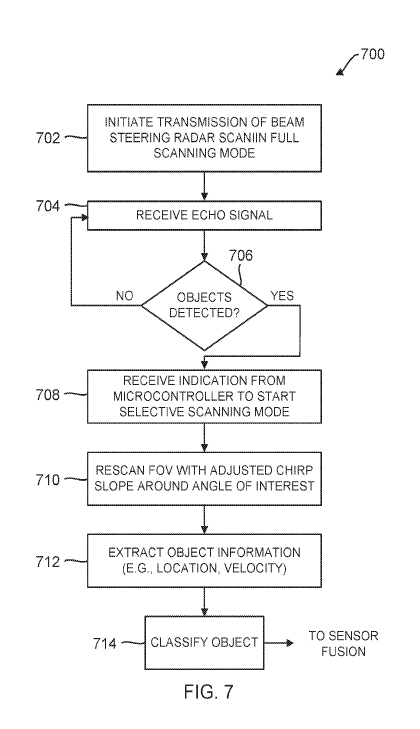
[0055] FIG. 7 is a flowchart of an example process 700 for operating a beam
steering radar
in an adjustable long-range mode in accordance with various examples. First,
the radar initiates
transmission of a beam steering scan in full scanning mode (702). Once an echo
is received
(704), the radar may detect objects (706) and/or receive an indication from
the microcontroller
338 to start scanning in the selective mode (708).
[0056] The indication may be at the direction of perception engine 304 or
from a mapping
unit or other such engine (not shown) in the vehicle that detects a curved
road. The indication
from the microcontroller instructs the radar to adjust its chirp slope so that
it scans an FoV area
around an angle of interest, e.g., around the angle of the curved road (710).
The chirp slope
may be increased to focus on shorter ranges around the curve and achieve
better resolution.
Objects in the area of interest are then detected and their information is
extracted (71 2) so that
they can be classified (714) by the perception engine 304 into vehicles,
cyclists, pedestrians,
infrastructure objects, animals, and so forth. The object classification is
sent to a sensor fusion
module, where it is analyzed together with object detection information from
other sensors
such as lidar and camera sensors. The radar 300 continues its scanning process
under the
direction of the microcontroller 338, which instructs the radar on when to
leave the selective
scanning mode and return to the full scanning mode and on which scan
parameters to use during
scanning (e.g., chirp slope, beam width, etc.).
[0057] FIG. 8 illustrates an example radar beam that is transmitted by the
radar 300 with a
narrow main beam 800 capable to reach a long range of 300 m or more and side
lobes that may
be reduced with the guard antennas 310 and 314 and with DSP processing in the
DSP module
356 of FIG. 3. This radar beam can be steered to any angle within the FoV to
enable the radar
300 to detect and classify objects. The scanning mode can be changed depending
on the road
conditions (e.g., whether curved or not, whether city street or highway),
environmental
conditions and so forth. The beams are dynamically controlled and their
parameters can be
adjusted as needed under the instruction of the microcontroller 338 and
perception engine 304.
[0058] These various examples support autonomous driving with improved
sensor
performance, all-weather/all-condition detection, advanced decision-making
algorithms and
interaction with other sensors through sensor fusion. These configurations
optimize the use of
-16-
CA 03145740 2021-12-30
WO 2021/003440 PCT/US2020/040768
radar sensors, as radar is not inhibited by weather conditions in many
applications, such as for
self-driving cars. The radar described here is effectively a "digital eye,"
having true 3D vision
and capable of human-like interpretation of the world.
[0059] It is appreciated that the previous description of the disclosed
examples is provided
to enable any person skilled in the art to make or use the present disclosure.
Various
modifications to these examples will be readily apparent to those skilled in
the art, and the
generic principles defined herein may be applied to other examples without
departing from the
spirit or scope of the disclosure. Thus, the present disclosure is not
intended to be limited to the
examples shown herein but is to be accorded the widest scope consistent with
the principles
and novel features disclosed herein.
[0060] As used herein, the phrase "at least one of' preceding a series of
items, with the
terms "and" or "or" to separate any of the items, modifies the list as a
whole, rather than each
member of the list (i.e., each item).The phrase "at least one of' does not
require selection of at
least one item; rather, the phrase allows a meaning that includes at least one
of any one of the
items, and/or at least one of any combination of the items, and/or at least
one of each of the
items. By way of example, the phrases "at least one of A, B, and C" or "at
least one of A, B, or
C" each refer to only A, only B, or only C; any combination of A, B, and C;
and/or at least one
of each of A, B, and C.
[0061] Furthermore, to the extent that the term "include," "have," or the
like is used in the
description or the claims, such term is intended to be inclusive in a manner
similar to the term
"comprise" as "comprise" is interpreted when employed as a transitional word
in a claim.
[0062] A reference to an element in the singular is not intended to mean
"one and only
one" unless specifically stated, but rather "one or more." The term "some"
refers to one or
more. Underlined and/or italicized headings and subheadings are used for
convenience only,
do not limit the subject technology, and are not referred to in connection
with the interpretation
of the description of the subject technology. All structural and functional
equivalents to the
elements of the various configurations described throughout this disclosure
that are known or
later come to be known to those of ordinary skill in the art are expressly
incorporated herein
by reference and intended to be encompassed by the subject technology.
Moreover, nothing
disclosed herein is intended to be dedicated to the public regardless of
whether such disclosure
is explicitly recited in the above description.
[0063] While this specification contains many specifics, these should not
be construed as
limitations on the scope of what may be claimed, but rather as descriptions of
particular
implementations of the subject matter. Certain features that are described in
this specification
-17-
CA 03145740 2021-12-30
WO 2021/003440 PCT/US2020/040768
in the context of separate embodiments can also be implemented in combination
in a single
embodiment. Conversely, various features that are described in the context of
a single
embodiment can also be implemented in multiple embodiments separately or in
any suitable
sub combination. Moreover, although features may be described above as acting
in certain
combinations and even initially claimed as such, one or more features from a
claimed
combination can in some cases be excised from the combination, and the claimed
combination
may be directed to a sub combination or variation of a sub combination.
[0064] The subject matter of this specification has been described in terms
of particular
aspects, but other aspects can be implemented and are within the scope of the
following claims.
For example, while operations are depicted in the drawings in a particular
order, this should
not be understood as requiring that such operations be performed in the
particular order shown
or in sequential order, or that all illustrated operations be performed, to
achieve desirable
results. The actions recited in the claims can be performed in a different
order and still achieve
desirable results. As one example, the processes depicted in the accompanying
figures do not
necessarily require the particular order shown, or sequential order, to
achieve desirable results.
Moreover, the separation of various system components in the aspects described
above should
not be understood as requiring such separation in all aspects, and it should
be understood that
the described program components and systems can generally be integrated
together in a single
hardware product or packaged into multiple hardware products. Other variations
are within the
scope of the following claim.
-18-