Note: Descriptions are shown in the official language in which they were submitted.
CA 03146648 2022-01-07
WO 2021/007561 PCT/US2020/041711
SYSTEM AND METHOD FOR REAL TIME CONTROL OF AN AUTONOMOUS
DEVICE
CROSS REFERENCE TO RELATED APPLICATIONS
[0001] This utility patent application is a continuation-in-part of U.S.
patent
application 16/800,497 filed February 25, 2020, entitled System and Method for
Surface
Feature Detection and Traversal (Attorney Docket # AA164) which is
incorporated herein
by reference in its entirety. This patent application claims the benefit of
U.S. Provisional
Patent Application Serial # 62/872,396 filed July 10, 2019, entitled Apparatus
for Long and
Short Range Sensors on an Autonomous Delivery Device (Attorney Docket #
AA028), U.S.
Provisional Patent Application Serial # 62/990,485 filed March 17, 2020,
entitled System
and Method for Managing an Occupancy Grid (Attorney Docket # AA037), and U.S.
Provisional Patent Application Serial # 62/872,320 filed July 10, 2019,
entitled System and
Method for Real-Time Control of the Configuration of an Autonomous Device
(Attorney
Docket # Z96).
[0002] This application is related to U.S. Patent Application
Serial No.
16/035,205, filed on July 13, 2018 entitled MOBILITY DEVICE (Atty. Dkt. No.
X80), U.S.
Patent Application Serial No. 15/787,613, filed on October 18, 2017 entitled
MOBILITY
DEVICE (Atty. Dkt. No. W10), U.S. Patent Application Serial No. 15/600,703,
filed on
May 20, 2017 entitled MOBILITY DEVICE (Atty. Dkt. No. U22), U.S. Patent
Application
Serial No. 15/982,737, entitled SYSTEM AND METHOD FOR SECURE REMOTE
CONTROL OF A MEDICAL DEVICE, filed on May 17, 2018 (Atty. Dkt. No. X55), U.S.
Provisional Application Serial No. 62/532,993, filed July 15, 2017, entitled
MOBILITY
DEVICE IMPROVEMENTS (Attorney Docket No. U30), U.S. Provisional Application
Serial No. 62/559,263, filed September 15, 2017, entitled MOBILITY DEVICE SEAT
(Attorney Docket No. V85), and U.S. Provisional Application Serial No.
62/581,670, filed
November 4, 2017, entitled MOBILITY DEVICE SEAT (Attorney Docket No. W07),
which are incorporated herein by reference in their entirety.
BACKGROUND
CA 03146648 2022-01-07
WO 2021/007561 PCT/US2020/041711
[0003] The present teachings relate generally to AVs, and more
specifically to
autonomous route planning, global occupancy grid management, on-vehicle
sensors, surface
feature detection and traversal, and real-time vehicle configuration changes.
[0004] Navigation of AVs and semi-autonomous vehicles (AVs) typically
relies on long
.. range sensors including, for example, but not limited to, LIDAR, cameras,
stereo cameras,
and radar. Long range sensors can sense between 4 and 100 meters from the AV.
In
contrast, object avoidance and/or surface detection typically relies on short
range sensors
including, for example, but not limited to, stereo-cameras, short-range radar,
and ultra-sonic
sensors. These short range sensors typically observe the area or volume around
the AV out
to about 5 meters. Sensors can enable, for example, orienting the AV within
its
environment and navigating streets, sidewalks, obstacles, and open spaces to
reach a desired
destination. Sensors can also enable visioning humans, signage, traffic
lights, obstacles,
and surface features.
[0005] Surface feature traversal can be challenging because surface
features, for
example, but not limited to, substantially discontinuous surface features
(SDSFs), can be
found amidst heterogeneous topology, and that topology can be unique to a
specific
geography. SDSFs, such as, for example, but not limited to, inclines, edges,
curbs, steps,
and curb-like geometries (referred to herein, in a non-limiting way, as SDSFs
or simply
surface features), however, can include some typical characteristics that can
assist in their
identification. Surface/road conditions and surface types can be recognized
and classified
by, for example, fusing multisensory data, which can be complex and costly.
Surface
features and condition can be used to control, in real-time, the physical
reconfiguration of
an AV.
[0006] Sensors can be used to enable the creation of an occupancy grid
that can represent
the world for path planning purposes for the AV. Path planning requires a grid
that
identifies a space as free, occupied, or unknown. However, a probability that
the space is
occupied can improve decision-making with respect to the space. Logodds
representation
of the probabilities can be used to increase the accuracy at the numerical
boundaries of the
probability of 0 and 1. The probability that the cell is occupied can depend
at least upon
new sensor information, previous sensor information, and prior occupancy
information.
2
CA 03146648 2022-01-07
WO 2021/007561 PCT/US2020/041711
[0007] What is needed is a system that combines gathered sensor data and
real-time
sensor data with the change of physical configuration of a vehicle to
accomplish variable
terrain traversal. What is needed is advantageous sensor placement to achieve
physical
configuration change, variable terrain traversal, and object avoidance. What
is needed is the
ability to locate SDSFs based on a multi-part model that is associated with
several criteria
for SDSF identification. What is needed is determining candidate surface
feature traversals
based upon criteria such as candidate traversal approach angle, candidate
traversal driving
surface on both sides of the candidate surface feature, and real-time
determination of
candidate traversal path obstructions. What is needed is a system and method
for
incorporating drivable surface and device mode information into occupancy grid
determination.
SUMMARY
[0008] The AV of the present teachings can autonomously navigate to a
desired location.
In some configurations, the AV can include sensors, a device controller
including a
perception subsystem, an autonomy subsystem, and a driver subsystem, a power
base, four
powered wheels, two caster wheels, and a cargo container. In some
configurations, the
perception and autonomy subsystems can receive and process sensor information
(perception) and map information (perception and autonomy), and can provide
direction to
the driver subsystem. The map information can include surface classifications
and
associated device mode. Movement of the AV, controlled by the driver
subsystem, and
enabled by the power base, can be sensed by the sensor subsystem, providing a
feedback
loop. In some configurations, SDSFs can be accurately identified from point
cloud data and
memorialized in a map, for example, according to the process described herein.
The
portions of the map associated with the location of the AV can be provided to
the AV
during navigation. The perception subsystem can maintain an occupancy grid
that can
inform the AV about the probability that a to-be-traversed path is currently
occupied. In
some configurations, the AV can operate in multiple distinct modes. The modes
can enable
complex terrain traversal, among other benefits. A combination of the map
(surface
classification, for example), the sensor data (sensing features surrounding
the AV), the
.. occupancy grid (probability that the upcoming path point is occupied), the
mode (ready to
3
CA 03146648 2022-01-07
WO 2021/007561
PCT/US2020/041711
traverse difficult terrain or not), and can be used to identify the direction,
configuration, and
speed of the AV.
[0009] With respect to preparing the map, in some configurations, the
method of the
present teachings for creating a map to navigate at least one SDSF encountered
by an AV,
where the AV travels a path over a surface, where the surface includes the at
least one
SDSF, and where the path includes a starting point and an ending point, the
method can
include, but is not limited to including, accessing point cloud data
representing the surface,
filtering the point cloud data, forming the filtered point cloud data into
proces sable parts,
and merging the processable parts into at least one concave polygon. The
method can
include locating and labeling the at least one SDSF in the at least one
concave polygon.
The locating and labeling can form labeled point cloud data. The method can
include
creating graphing polygons based at least on the at least one concave polygon,
and choosing
the path from the starting point to the ending point based at least on the
graphing polygons.
When navigating, the AV can traverse the at least one SDSF along the path.
[0010] Filtering the point cloud data can optionally include conditionally
removing
points representing transient objects and points representing outliers from
the point cloud
data, and replacing the removed points having a pre-selected height. Forming
processing
parts can optionally include segmenting the point cloud data into the
processable parts, and
removing points of a pre-selected height from the processable parts. Merging
the
processable parts can optionally include reducing the size of the processable
parts by
analyzing outliers, voxels, and normal, growing regions from the reduced-size
processable
parts, determining initial drivable surfaces from the grown regions,
segmenting and
meshing the initial drivable surfaces, locating polygons within the segmented
and meshed
initial drivable surfaces, and setting the drivable surfaces based at least on
the polygons.
Locating and labeling the at least one SDSF feature can optionally include
sorting the point
cloud data of the drivable surfaces according to a SDSF filter, the SDSF
filter including at
least three categories of points, and locating the at least one SDSF point
based at least on
whether the categories of points, in combination, meet at least one first pre-
selected
criterion. The method can optionally include creating at least one SDSF
trajectory based at
least on whether a plurality of the at least one SDSF points, in combination,
meet at least
one second pre-selected criterion. Creating graphing polygons further can
optionally
4
CA 03146648 2022-01-07
WO 2021/007561
PCT/US2020/041711
include creating at least one polygon from the at least one drivable surface.
The at least one
polygon can include edges. Creating graphing polygons can include smoothing
the edges,
forming a driving margin based on the smoothed edges, adding the at least one
SDSF
trajectory to the at least one drivable surface, and removing edges from the
at least one
drivable surface according to at least one third pre-selected criterion.
Smoothing of the
edges can optionally include trimming the edges outward. Forming a driving
margin of the
smoothed edges can optionally include trimming the outward edges inward.
[0011] In some configurations, the system of the present teachings for
creating a map for
navigating at least one SDSF encountered by a AV, where the AV travels a path
over a
surface, where the surface includes the at least one SDSF, where the path
includes a starting
point and an ending point, the system can include, but is not limited to
including, a first
processor accessing point cloud data representing the surface, a first filter
filtering the point
cloud data, a second processor forming processable parts from the filtered
point cloud data,
a third processor merging the processable parts into at least one concave
polygon, a fourth
processor locating and labeling the at least one SDSF in the at least one
concave polygon,
the locating and labeling forming labeled point cloud data, a fifth processor
creating
graphing polygons, and a path selector choosing the path from the starting
point to the
ending point based at least on the graphing polygons. The AV can traverse the
at least one
SDSF along the path.
[0012] The first filter can optionally include executable code that can
include, but is not
limited to including, conditionally removing points representing transient
objects and points
representing outliers from the point cloud data, and replacing the removed
points having a
pre-selected height. The segmenter can optionally include executable code that
can include,
but is not limited to including, segmenting the point cloud data into the
processable parts,
and removing points of a pre-selected height from the processable parts. The
third
processor can optionally include executable code that can include, but is not
limited to
including, reducing the size of the processable parts by analyzing outliers,
voxels, and
normal, growing regions from the reduced-size processable parts, determining
initial
drivable surfaces from the grown regions, segmenting and meshing the initial
drivable
surfaces, locating polygons within the segmented and meshed initial drivable
surfaces, and
setting the drivable sur faces based at least on the polygons. The fourth
processor can
5
CA 03146648 2022-01-07
WO 2021/007561 PCT/US2020/041711
optionally include executable code that can include, but is not limited to
including, sorting
the point cloud data of the drivable surfaces according to a SDSF filter, the
SDSF filter
including at least three categories of points, and locating the at least one
SDSF point based
at least on whether the categories of points, in combination, meet at least
one first pre-
selected criterion. The system can optionally include executable code that can
include, but
is not limited to including, creating at least one SDSF trajectory based at
least on whether a
plurality of the at least one SDSF points, in combination, meet at least one
second pre-
selected criterion.
[0013] Creating graphing polygons can optionally include executable code
that can
include, but is not limited to including, creating at least one polygon from
the at least one
drivable surface, the at least one polygon including edges, smoothing the
edges, forming a
driving margin based on the smoothed edges, adding the at least one SDSF
trajectory to the
at least one drivable surface, and removing edges from the at least one
drivable surface
according to at least one third pre-selected criterion. Smoothing the edges
can optionally
include executable code that can include, but is not limited to including,
trimming the edges
outward. Forming a driving margin of the smoothed edges can optionally include
executable code that can include, but is not limited to including, trimming
the outward
edges inward.
[0014] In some configurations, the method of the present teachings for
creating a map for
navigating at least one SDSF encountered by a AV, where the AV travels a path
over a
surface, where the surface includes the at least one SDSF, where the path
includes a starting
point and an ending point, the method can include, but is not limited to
including, accessing
a route topology. The route topology can include at least one graphing polygon
that can
include filtered point cloud data. The point cloud data can include labeled
features and a
.. drivable margin. The method can include transforming the point cloud data
into a global
coordinate system, determining boundaries of the at least one SDSF, creating
SDSF buffers
of a pre-selected size around the boundaries, determining which of the at
least one SDSFs
can be traversed based at least on at least one SDSF traversal criterion,
creating an
edge/weight graph based at least on the at least one SDSF traversal criterion,
the
transformed point cloud data, and the route topology, and choosing a path from
the starting
point to the destination point based at least on the edge/weight graph.
6
CA 03146648 2022-01-07
WO 2021/007561 PCT/US2020/041711
[0015] The at least one SDSF traversal criterion can optionally include a
pre-selected
width of the at least one SDSF and a pre-selected smoothness of the at least
one SDSF, a
minimum ingress distance and a minimum egress distance between the at least
one SDSF
and the AV including a drivable surface, and a minimum ingress distance
between the at
least one SDSF and the AV that can accommodate approximately a 90 approach by
the AV
to the at least one SDSF.
[0016] In some configurations, the system of the present teachings for
creating a map for
navigating at least one SDSF encountered by a AV, where the AV travels a path
over a
surface, where the surface includes the at least one SDSF, and where the path
includes a
starting point and an ending point, the system can include, but is not limited
to including, a
sixth processor accessing a route topology. The route topology can include at
least one
graphing polygon that can include filtered point cloud data. The point cloud
data can
include labeled features and a drivable margin. The system can include a
seventh processor
transforming the point cloud data into a global coordinate system, and an
eighth processor
determining boundaries of the at least one SDSF. The eighth processor can
create SDSF
buffers of a pre-selected size around the boundaries. The system can include a
ninth
processor determining which of the at least one SDSFs can be traversed based
at least on at
least one SDSF traversal criterion, a tenth processor creating an edge/weight
graph based at
least on the at least one SDSF traversal criterion, the transformed point
cloud data, and the
route topology, and a base controller choosing a path from the starting point
to the
destination point based at least on the edge/weight graph.
[0017] In some configurations, the method of the present teachings for
creating a map for
navigating at least one SDSF encountered by a AV, where the AV travels a path
over a
surface, where the surface includes the at least one SDSF, and where the path
includes a
starting point and an ending point, the method can include, but is not limited
to including,
accessing point cloud data representing the surface. The method can include
filtering the
point cloud data, forming the filtered point cloud data into processable
parts, and merging
the processable parts into at least one concave polygon. The method can
include locating
and labeling the at least one SDSF in the at least one concave polygon. The
locating and
labeling can form labeled point cloud data. The method can include creating
graphing
polygons based at least on the at least one concave polygon. The graphing
polygons can
7
CA 03146648 2022-01-07
WO 2021/007561 PCT/US2020/041711
form a route topology, and the point cloud data can include labeled features
and a drivable
margin. The method can include transforming the point cloud data into a global
coordinate
system, determining boundaries of the at least one SDSF, creating SDSF buffers
of a pre-
selected size around the boundaries, determining which of the at least one
SDSFs can be
traversed based at least on at least one SDSF traversal criterion, creating an
edge/weight
graph based at least on the at least one SDSF traversal criterion, the
transformed point cloud
data, and the route topology, and choosing a path from the starting point to
the destination
point based at least on the edge/weight graph.
[0018] Filtering the point cloud data can optionally include
conditionally removing
points representing transient objects and points representing outliers from
the point cloud
data, and replacing the removed points having a pre-selected height. Forming
processing
parts can optionally include segmenting the point cloud data into the
processable parts, and
removing points of a pre-selected height from the processable parts. Merging
the
processable parts can optionally include reducing the size of the processable
parts by
analyzing outliers, voxels, and normal, growing regions from the reduced-size
processable
parts, determining initial drivable surfaces from the grown regions,
segmenting and
meshing the initial drivable surfaces, locating polygons within the segmented
and meshed
initial drivable surfaces, and setting the drivable surfaces based at least on
the polygons.
Locating and labeling the at least one SDSF feature can optionally include
sorting the point
cloud data of the drivable surfaces according to a SDSF filter, the SDSF
filter including at
least three categories of points, and locating the at least one SDSF point
based at least on
whether the categories of points, in combination, meet at least one first pre-
selected
criterion. The method can optionally include creating at least one SDSF
trajectory based at
least on whether a plurality of the at least one SDSF points, in combination,
meet at least
one second pre-selected criterion. Creating graphing polygons further can
optionally
include creating at least one polygon from the at least one drivable surface.
The at least one
polygon can include edges. Creating graphing polygons can include smoothing
the edges,
forming a driving margin based on the smoothed edges, adding the at least one
SDSF
trajectory to the at least one drivable surface, and removing edges from the
at least one
drivable surface according to at least one third pre-selected criterion.
Smoothing of the
edges can optionally include trimming the edges outward. Forming a driving
margin of the
8
CA 03146648 2022-01-07
WO 2021/007561 PCT/US2020/041711
smoothed edges can optionally include trimming the outward edges inward. The
at least
one SDSF traversal criterion can optionally include a pre-selected width of
the at least one
and a pre-selected smoothness of the at least one SDSF, a minimum ingress
distance and a
minimum egress distance between the at least one SDSF and the AV including a
drivable
surface, and a minimum ingress distance between the at least one SDSF and the
AV that can
accommodate approximately a 90 approach by the AV to the at least one SDSF.
[0019] In some configurations, the system of the present teachings for
creating a map for
navigating at least one SDSF encountered by a AV, where the AV travels a path
over a
surface, where the surface includes the at least one SDSF, where the path
includes a starting
point and an ending point, the system can include, but is not limited to
including, a point
cloud accessor accessing point cloud data representing the surface, a first
filter filtering the
point cloud data, a segmenter forming processable parts from the filtered
point cloud data, a
third processor merging the processable parts into at least one concave
polygon, a fourth
processor locating and labeling the at least one SDSF in the at least one
concave polygon,
the locating and labeling forming labeled point cloud data, a fifth processor
creating
graphing polygons. The route topology can include at least one graphing
polygon that can
include filtered point cloud data. The point cloud data can include labeled
features and a
drivable margin. The system can include a seventh processor transforming the
point cloud
data into a global coordinate system, and a eighth processor determining
boundaries of the
at least one SDSF. The eighth processor can create SDSF buffers of a pre-
selected size
around the boundaries. The system can include a ninth processor determining
which of the
at least one SDSFs can be traversed based at least on at least one SDSF
traversal criterion, a
tenth processor creating an edge/weight graph based at least on the at least
one SDSF
traversal criterion, the transformed point cloud data, and the route topology,
and a base
controller choosing a path from the starting point to the destination point
based at least on
the edge/weight graph.
[0020] The first filter can optionally include executable code that can
include, but is not
limited to including, conditionally removing points representing transient
objects and points
representing outliers from the point cloud data, and replacing the removed
points having a
pre-selected height. The segmenter can optionally include executable code that
can include,
but is not limited to including, segmenting the point cloud data into the
processable parts,
9
CA 03146648 2022-01-07
WO 2021/007561
PCT/US2020/041711
and removing points of a pre-selected height from the processable parts. The
third
processor can optionally include executable code that can include, but is not
limited to
including, reducing the size of the processable parts by analyzing outliers,
voxels, and
normal, growing regions from the reduced-size processable parts, determining
initial
drivable surfaces from the grown regions, segmenting and meshing the initial
drivable
surfaces, locating polygons within the segmented and meshed initial drivable
surfaces, and
setting the drivable surfaces based at least on the polygons. The fourth
processor can
optionally include executable code that can include, but is not limited to
including, sorting
the point cloud data of the drivable surfaces according to a SDSF filter, the
SDSF filter
including at least three categories of points, and locating the at least one
SDSF point based
at least on whether the categories of points, in combination, meet at least
one first pre-
selected criterion. The system can optionally include executable code that can
include, but
is not limited to including, creating at least one SDSF trajectory based at
least on whether a
plurality of the at least one SDSF points, in combination, meet at least one
second pre-
selected criterion.
[0021] Creating graphing polygons can optionally include executable code
that can
include, but is not limited to including, creating at least one polygon from
the at least one
drivable surface, the at least one polygon including edges, smoothing the
edges, forming a
driving margin based on the smoothed edges, adding the at least one SDSF
trajectory to the
at least one drivable surface, and removing edges from the at least one
drivable surface
according to at least one third pre-selected criterion. Smoothing the edges
can optionally
include executable code that can include, but is not limited to including,
trimming the edges
outward. Forming a driving margin of the smoothed edges can optionally include
executable code that can include, but is not limited to including, trimming
the outward
edges inward.
[0022] In some configurations, a SDSF can be identified by its
dimensions. For
example, a curb can include, but is not limited to including, a width of about
0.6-0.7m. In
some configurations, point cloud data can be processed to locate SDSFs, and
those data can
be used to prepare a path for the AV from a beginning point to a destination.
In some
configurations, the path can be included in the map and provided to the
perception
subsystem. As the AV is traveling the path, in some configurations, SDSF
traversal can be
CA 03146648 2022-01-07
WO 2021/007561 PCT/US2020/041711
accommodated through sensor-based positioning of the AV enabled in part by the
perception subsystem. The perception subsystem can execute on at least one
processor
within the AV.
[0023] The AV can include, but is not limited to including, a power base
including two
.. powered front-wheels, two powered back-wheels, energy storage, and at least
one
processor. The power base can be configured to move at a commanded velocity.
The AV
can include a cargo platform, mechanically attached to the power base,
including a plurality
of short-range sensors. The AV can include a cargo container, mounted atop the
cargo
platform in some configurations, having a volume for receiving a one or more
objects to
deliver. The AV can include a long-range sensor suite, mounted atop the cargo
container in
some configurations, that can include, but is not limited to including, LIDAR
and one or
more cameras. The AV can include a controller that can receive data from the
long-range
sensor suite and the short-range sensor suite.
[0024] The short-range sensor suite can optionally detect at least one
characteristic of the
drivable surface, and can optionally include stereo cameras, an IR projector,
two image
sensors, an RGB sensor, and radar sensors. The short-range sensor suite can
optionally
supply RGB-D data to the controller. The controller can optionally determine
the geometry
of the road surface based on RGB-D data received from the short-range sensor
suite. The
short-range sensor suite can optionally detect objects within 4 meters of the
AV, and the
long-range sensor suite can optionally detect objects more than 4 meters from
the AV.
[0025] The perception subsystem can use the data collected by the sensors
to populate
the occupancy grid. The occupancy grid of the present teachings can be
configured as a 3D
grid of points surrounding the AV, with the AV occupying the center point. In
some
configurations, the occupancy grid can stretch 10m to the left, right, back,
and front of the
AV. The grid can include, approximately, the height of the AV, and can
virtually travel
with the AV as it moves, representing obstacles surrounding the AV. The grid
can be
converted to two dimensions by reducing its vertical axis, and can be divided
into polygons,
for example, but not limited to, approximately 5cm x 5cm in size. Obstacles
appearing in
the 3D space around the AV can be reduced into a 2D shape. If the 2D shape
overlaps any
segment of one of the polygons, the polygon can be given the value of 100,
indicating that
11
CA 03146648 2022-01-07
WO 2021/007561 PCT/US2020/041711
the space is occupied. Any polygons left unfilled-in can be given the value of
0, and can be
referred to as free space, where the AV can move.
[0026] As the AV navigates, it can encounter situations in which a change
of
configuration of the AV could be required. A method of the present teachings
for real-time
control of a configuration of a in some configurations, where the in some
configurations
includes a chassis, at least four wheels, a first side of the chassis operably
coupled with at
least one of the at least four wheels, and an opposing second side of the
chassis operably
coupled with at least one of the at least four wheels, the method can include,
but is not
limited to including, receiving environmental data, determining a surface type
based at least
on the environmental data, determining a mode based at least on the surface
type and a first
configuration, determining a second configuration based at least on the mode
and the
surface type, determining movement commands based at least on the second
configuration,
and controlling the configuration of the device by using the movement commands
to change
the device from the first configuration to the second configuration.
[0027] The method can optionally include populating the occupancy grid
based at least
on the surface type and the mode. The environmental data can optionally
include RGB-D
image data and a topology of a road surface. The configuration can optionally
include two
pairs of clustered of the at least four wheels. A first pair of the two pairs
can be positioned
on the first side, and a second pair of the two pairs being can be positioned
on the second
side. The first pair can include a first front wheel and a first rear wheel,
and the second pair
can include a second front wheel and a second rear wheel. The controlling of
the
configuration can optionally include coordinated powering of the first pair
and the second
pair based at least on the environmental data. The controlling of the
configuration can
optionally include transitioning from driving the at least four wheels and a
pair of casters
retracted to driving two wheels with the clustered first pair and the
clustered second pair
rotated to lift the first front wheel and the second front wheel. The pair of
casters can be
operably coupled with the chassis. The device can rest on the first rear
wheel, the second
rear wheel, and the pair of casters. The controlling of the configuration can
optionally
include rotating a pair of clusters operably coupled with two powered wheels
on the first
side and two powered wheels on the second side based at least on the
environmental data.
12
CA 03146648 2022-01-07
WO 2021/007561 PCT/US2020/041711
[0028] The system of the present teachings for real-time control of a
configuration of an
AV, can include, but is not limited to including, a device processor and a
powerbase
processor. The AV can include a chassis, at least four wheels, a first side of
the chassis, and
an opposing second side of the chassis. The device processor can receive real-
time
environmental data surrounding the AV, determine a surface type based at least
on the
environmental data, determine a mode based at least on the surface type and a
first
configuration, and determine a second configuration based at least on the mode
and the
surface type. The power base processor can enable the AV to move based at
least on the
second configuration, and can enable the AV to change from the first
configuration to the
second configuration. The device processor can optionally include populating
the
occupancy grid based at least on the surface type and the mode.
[0029] During navigation, the AV can encounter SDSFs that can require
maneuvering
the AV for successful traverse. In some configurations, the method of the
present teachings
for navigating the AV along a path line in a travel area towards a goal point
across at least
one SDSF, the AV including a leading edge and a trailing edge, can include,
but is not
limited to including, receiving SDSF information and obstacle information for
the travel
area, detecting at least one candidate SDSF from the SDSF information, and
selecting a
SDSF line from the at least one candidate SDSF line based on at least one
selection
criterion. The method can include determining at least one traversable part of
the selected
.. SDSF line based on at least one location of at least one obstacle found in
the obstacle
information in the vicinity of the selected SDSF line, heading the AV,
operating at a first
speed towards the at least one traversable part, by turning the AV to travel
along a line
perpendicular to the traversable part, and constantly correcting a heading of
the AV based
on a relationship between the heading and the perpendicular line. The method
can include
driving the AV at a second speed by adjusting the first speed of the AV based
at least on the
heading and a distance between the AV and the traversable part. If a SDSF
associated with
the at least one traversable part is elevated relative to a surface of the
travel route, the
method can include traversing the SDSF by elevating the leading edge relative
to the
trailing edge and driving the AV at a third increased speed per degree of
elevation, and
driving the AV at a fourth speed until the AV has cleared the SDSF.
13
CA 03146648 2022-01-07
WO 2021/007561 PCT/US2020/041711
[0030] Detecting at least one candidate SDSF from the SDSF information
can optionally
include (a) drawing a closed polygon encompassing a location of the AV, and a
location of
a goal point, (b) drawing a path line between the goal point and the location
of the AV, (c)
selecting two SDSF points from the SDSF information, the SDSF points being
located
within the polygon, and (d) drawing a SDSF line between the two points.
Detecting at least
one candidate SDSF can include (e) repeating steps (c)-(e) if there are fewer
than a first pre-
selected number of points within a first pre-selected distance of the SDSF
line, and if there
have been less than a second pre-selected number of attempts at choosing the
SDSF points,
drawing a line between them, and having fewer than the first pre-selected
number of points
around the SDSF line. Detecting at least one candidate SDSF can include (f)
fitting a curve
to the SDSF points that fall within the first pre-selected distance of the
SDSF line if there
are the first pre-selected number of points or more, (g) identifying the curve
as the SDSF
line if a first number of the SDSF points that are within the first pre-
selected distance of the
curve exceeds a second number of the SDSF points within the first pre-selected
distance of
the SDSF line, and if the curve intersects the path line, and if there are no
gaps between the
SDSF points on the curve that exceed a second pre-selected distance. Detecting
at least one
candidate SDSF can include (h) repeating steps (f)-(h) if the number of points
that are
within the first pre-selected distance of the curve does not exceed the number
of points
within the first pre-selected distance of the SDSF line, or if the curve does
not intersect the
path line, or if there are gaps between the SDSF points on the curve that
exceed the second
pre-selected distance, and if the SDSF line is not remaining stable, and if
steps (f)-(h) have
not been attempted more than the second pre-selected number of attempts.
[0031] The closed polygon can optionally include a pre-selected width,
and the pre-
selected width can optionally include a width dimension of the AV. Selecting
the SDSF
points can optionally include random selection. The at least one selection
criterion can
optionally include a first number of the SDSF points within the first pre-
selected distance of
the curve exceeds a second number of SDSF points within the first pre-selected
distance of
the SDSF line, the curve intersects the path line, and there are no gaps
between the SDSF
points on the curve that exceed a second pre-selected distance.
[0032] Determining at least one traversable part of the selected SDSF can
optionally
include selecting a plurality of obstacle points from the obstacle
information. Each of the
14
CA 03146648 2022-01-07
WO 2021/007561
PCT/US2020/041711
plurality of obstacle points can include a probability that the obstacle point
is associated
with the at least one obstacle. Determining at least one traversable part can
include
projecting the plurality of obstacle points to the SDSF line if the
probability is higher than a
pre-selected percent, and any of the plurality of obstacle points lies between
the SDSF line
and the goal point, and if any of the plurality of obstacle points is less
than a third pre-
selected distance from the SDSF line, forming at least one projection.
Determining at least
one traversable part can optionally include connecting at least two of the at
least one
projection to each other, locating end points of the connected at least two
projections along
the SDSF line, marking as a non-traversable SDSF section the connected at
least two
projections, and marking as at least one traversable section the SDSF line
outside of the
non-traversable section.
[0033] Traversing the at least one traversable part of the SDSF can
optionally include
heading the AV, operating at a first speed, towards the traversable part,
turning the AV to
travel along a line perpendicular to the traversable part, constantly
correcting a heading of
the AV based on the relationship between the heading and the perpendicular
line, and
driving the AV at a second speed by adjusting the first speed of the AV based
at least on the
heading and a distance between the AV and the traversable part. Traversing the
at least one
traversable part of the SDSF can optionally include if the SDSF is elevated
relative to a
surface of the travel route, traversing the SDSF by elevating the leading edge
relative to the
trailing edge and driving the AV at a third increased speed per degree of
elevation, and
driving the AV at a fourth speed until the AV has cleared the SDSF.
[0034] Traversing the at least one traversable part of the SDSF can
alternatively
optionally include (a) ignoring updated of the SDSF information and driving
the AV at a
pre-selected speed if a heading error is less than a third pre-selected amount
with respect to
a line perpendicular to the SDSF line, (b) driving the AV forward and
increasing the speed
of the AV to an eighth pre-selected speed per degree of elevation if an
elevation of a front
part of the AV relative to a rear part of the AV is between a sixth pre-
selected amount and a
fifth pre-selected amount, (c) driving the AV forward at a seventh pre-
selected speed if the
front part is elevated less than a sixth pre-selected amount relative to the
rear part, and (d)
repeating steps (a)-(d) if the rear part is less than or equal to a fifth pre-
selected distance
from the SDSF line.
CA 03146648 2022-01-07
WO 2021/007561
PCT/US2020/041711
[0035] In some configurations, the SDSF and the wheels of the AV can be
automatically
aligned to avoid system instability. Automatic alignment can be implemented
by, for
example, but not limited to, continually testing for and correcting the
heading of the AV as
the AV approaches the SDSF. Another aspect of the SDSF traversal feature of
the present
teachings is that the SDSF traversal feature automatically confirms that
sufficient free space
exists around the SDSF before attempting traversal. Yet another aspect of the
SDSF
traversal feature of the present teachings is that traversing SDSFs of varying
geometries is
possible. Geometries can include, for example, but not limited to, squared and
contoured
SDSFs. The orientation of the AV with respect to the SDSF can determine in
what speed
and direction the AV proceeds. The SDSF traversal feature can adjust the speed
of the AV
in the vicinity of SDSFs. When the AV ascends the SDSF, the speed can be
increased to
assist the AV in traversing the SDSF.
[0036] 1. An autonomous delivery vehicle comprising: a power base
including two
powered front wheels, two powered back wheels and energy storage, the power
base
configured to move at a commanded velocity and in a commanded direction to
perform a
transport of at least one object; a cargo platform including a plurality of
short-range sensors,
the cargo platform mechanically attached to the power base; a cargo container
with a
volume for receiving the at least one object, the cargo container mounted on
top of the
cargo platform; a long-range sensor suite comprising LIDAR and one or more
cameras, the
long-range sensor suite mounted on top of the cargo container; and a
controller to receive
data from the long-range sensor suite and the plurality of short-range
sensors, the controller
determining the commanded velocity and the commanded direction based at least
on the
data, the controller providing the commanded velocity and the commanded
direction to the
power base to complete the transport. 2. The autonomous delivery vehicle of
claim 1
wherein the data from the plurality of short-range sensors comprise at least
one
characteristic of a surface upon which the power base travels. 3. The
autonomous delivery
vehicle of claim 1 wherein the plurality of short-range sensors comprises at
least one stereo
camera. 4. The autonomous delivery vehicle of claim 1 wherein the plurality of
short-range
sensors comprise at least one IR projector, at least one image sensor, and at
least one RGB
sensor. 5. The autonomous delivery vehicle of claim 1 wherein the plurality of
short-range
sensors comprises at least one radar sensor. 6. The autonomous delivery
vehicle of claim 1
16
CA 03146648 2022-01-07
WO 2021/007561 PCT/US2020/041711
wherein the data from the plurality of short-range sensors comprise RGB-D
data. 7. The
autonomous delivery vehicle of claim 1 wherein the controller determines a
geometry of a
road surface based on RGB-D data received from the plurality of short-range
sensors. 8.
The autonomous delivery vehicle of claim 1 wherein the plurality of short-
range sensors
detect objects within 4 meters of the AV and the long-range sensor suite
detects objects
more than 4 meters from the autonomous delivery vehicle. 9. The autonomous
delivery
vehicle of claim 1 wherein the plurality of short-range sensors comprise a
cooling circuit.
10. The autonomous delivery vehicle of claim 1 wherein the plurality of short-
range sensors
comprise an ultrasonic sensor. 11. The autonomous delivery vehicle of claim 2
wherein the
controller comprises: executable code, the executable code including:
accessing a map, the
map formed by a map processor, the map processor comprising: first processor
accessing
point cloud data from the long-range sensor suite, the point cloud data
representing the
surface; a filter filtering the point cloud data; a second processor forming
processable parts
from the filtered point cloud data; a third processor merging the processable
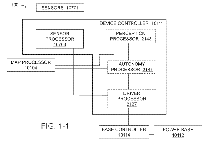
parts into at
least one polygon; a fourth processor locating and labeling the at least one
substantially
discontinuous surface feature (SDSF) in the at least one polygon, if present,
the locating and
labeling forming labeled point cloud data; a fifth processor creating graphing
polygons from
the labeled point cloud data; and a sixth processor choosing a path from a
starting point to
an ending point based at least on the graphing polygons, the AV traversing the
at least one
SDSF along the path. 12. The autonomous delivery vehicle as in claim 11
wherein the filter
comprises: a seventh processor executing code including: conditionally
removing points
representing transient objects and points representing outliers from the point
cloud data; and
replacing the removed points having a pre-selected height. 13. The autonomous
delivery
vehicle as in claim 11 wherein the second processor includes the executable
code
comprising: segmenting the point cloud data into the processable parts; and
removing points
of a pre-selected height from the processable parts. 14. The autonomous
delivery vehicle as
in claim 11 wherein the third processor includes the executable code
comprising: reducing a
size of the processable parts by analyzing outliers, voxels, and normals;
growing regions
from the reduced-size processable parts; determining initial drivable surfaces
from the
grown regions; segmenting and meshing the initial drivable surfaces; locating
polygons
within the segmented and meshed initial drivable surfaces; and setting at
least one drivable
17
CA 03146648 2022-01-07
WO 2021/007561 PCT/US2020/041711
surface based at least on the polygons. 15. The autonomous delivery vehicle as
in claim 14
wherein the fourth processor includes the executable code comprising: sorting
the point
cloud data of the initial drivable surfaces according to a SDSF filter, the
SDSF filter
including at least three categories of points; and locating at least one SDSF
point based at
least on whether the at least three categories of points, in combination, meet
at least one first
pre-selected criterion. 16. The autonomous delivery vehicle as in claim 15
wherein the
fourth processor includes the executable code comprising: creating at least
one SDSF
trajectory based at least on whether a plurality of the at least one SDSF
point, in
combination, meet at least one second pre-selected criterion. 17. The
autonomous delivery
vehicle as in claim 14 wherein creating graphing polygons includes an eighth
processor
including the executable code comprising: creating at least one polygon from
the at least
one drivable surface, the at least one polygon including exterior edges;
smoothing the
exterior edges; forming a driving margin based on the smoothed exterior edges;
adding the
at least one SDSF trajectory to the at least one drivable surface; and
removing interior edges
from the at least one drivable surface according to at least one third pre-
selected criterion.
18. The autonomous delivery vehicle as in claim 17 wherein the smoothing the
exterior
edges includes a ninth processor including the executable code comprising:
trimming the
exterior edges outward forming outward edges. 19. The autonomous delivery
vehicle as in
claim 18 wherein forming the driving margin of the smoothed exterior edges
includes a
tenth processor including the executable code comprising: trimming the outward
edges
inward. 20. The autonomous delivery vehicle as in claim 1 wherein the
controller
comprises: a subsystem for navigating at least one substantially discontinuous
surface
feature (SDSF) encountered by the autonomous delivery vehicle (AV), the AV
traveling a
path over a surface, the surface including the at least one SDSF, the path
including a starting
point and an ending point, the subsystem comprising: a first processor
accessing a route
topology, the route topology including at least one graphing polygon including
filtered point
cloud data, the filtered point cloud data including labeled features, the
point cloud data
including a drivable margin; a second processor transforming the point cloud
data into a
global coordinate system; a third processor determining boundaries of the at
least one
SDSF, the third processor creating SDSF buffers of a pre-selected size around
the
boundaries; a fourth processor determining which of the at least one SDSFs can
be traversed
18
CA 03146648 2022-01-07
WO 2021/007561
PCT/US2020/041711
based at least on at least one SDSF traversal criterion; a fifth processor
creating an
edge/weight graph based at least on the at least one SDSF traversal criterion,
the
transformed point cloud data, and the route topology; and a base controller
choosing the
path from the starting point to the ending point based at least on the
edge/weight graph. 21.
The autonomous delivery vehicle as in claim 20 wherein the at least one SDSF
traversal
criterion comprises: a pre-selected width of the at least one and a pre-
selected smoothness
of the at least one SDSF; a minimum ingress distance and a minimum egress
distance
between the at least one SDSF and the AV including a drivable surface; and the
minimum
ingress distance between the at least one SDSF and the AV accommodating
approximately
a 90 approach by the AV to the at least one SDSF.
[0037] 22. A
method for managing a global occupancy grid for an autonomous device,
the global occupancy grid including global occupancy grid cells, the global
occupancy grid
cells being associated with occupied probability, the method comprising:
receiving sensor
data from sensors associated with the autonomous device; creating a local
occupancy grid
based at least on the sensor data, the local occupancy grid having local
occupancy grid cells;
if the autonomous device has moved from a first area to a second area,
accessing historical
data associated with the second area; creating a static grid based at least on
the historical
data; moving the global occupancy grid to maintain the autonomous device in a
central
position of the global occupancy grid; updating the moved global occupancy
grid based on
the static grid; marking at least one of the global occupancy grid cells as
unoccupied, if the
at least one of the global occupancy grid cells coincides with a location of
the autonomous
device; for each of the local occupancy grid cells, calculating a position of
the local
occupancy grid cell on the global occupancy grid; accessing a first occupied
probability
from the global occupancy grid cell at the position; accessing a second
occupied probability
from the local occupancy grid cell at the position; and computing a new
occupied
probability at the position on the global occupancy grid based at least on the
first occupied
probability and the second occupied probability. 23. The method as in claim 22
further
comprising: range-checking the new occupied probability. 24. The method as in
claim 23
wherein the range-checking comprises: setting the new occupied probability to
0 if the new
occupied probability <0; and setting the new occupied probability to 1 if the
new occupied
probability >1. 25. The method as in claim 22 further comprising: setting the
global
19
CA 03146648 2022-01-07
WO 2021/007561
PCT/US2020/041711
occupancy grid cell to the new occupied probability. 26. The method as in
claim 23 further
comprising: setting the global occupancy grid cell to the range-checked new
occupied
probability.
[0038] 27. A method for creating and managing occupancy grids comprising:
transforming, by a local occupancy grid creation node, sensor measurements to
a frame of
reference associated with a device; creating a time-stamped measurement
occupancy grid;
publishing the time-stamped measurement occupancy grid as a local occupancy
grid;
creating a plurality of local occupancy grids; creating a static occupancy
grid based on
surface characteristics in a repository, the surface characteristics
associated with a position
.. of the device; moving a global occupancy grid associated with the position
of the device to
maintain the device and the local occupancy grid approximately centered with
respect to the
global occupancy grid; adding information from the static occupancy grid to
the global
occupancy grid; marking an area in the global occupancy grid currently
occupied by the
device as unoccupied; for each of at least one cell in each local occupancy
grid, determining
a location of the at least one cell in the global occupancy grid; accessing a
first value at the
location; determining a second value at the location based on a relationship
between the first
value and a cell value at the at least one cell in the local occupancy grid;
comparing the
second value against a pre-selected probability range; and setting the global
occupancy grid
with the new value if a probability value is within the pre-selected
probability range. 28.
The method as in claim 27 further comprising: publishing the global
occupancy grid.
29. The method as in claim 27 wherein the surface characteristics comprise
surface type and
surface discontinuities. 30. The method as in claim 27 wherein the
relationship comprises
summing. 31. A system for creating and managing occupancy grids comprising: a
plurality
of local grid creation nodes creating at least one local occupancy grid, the
at least one local
occupancy grid associated with a position of a device, the at least one local
occupancy grid
including at least one cell; a global occupancy grid manager accessing the at
least one local
occupancy grid, the global occupancy grid manager creating a static occupancy
grid based
on surface characteristics in a repository, the surface characteristics
associated with the
position of the device, moving a global occupancy grid associated with the
position of the
device to maintain the device and at least one the local occupancy grid
approximately
centered with respect to the global occupancy grid; adding information from
the static
CA 03146648 2022-01-07
WO 2021/007561 PCT/US2020/041711
occupancy grid to at least one global occupancy grid; marking an area in the
global
occupancy grid currently occupied by the device as unoccupied; for each of the
at least one
cell in each local occupancy grid, determining a location of the at least one
cell in the global
occupancy grid; accessing a first value at the location; determining a second
value at the
location based on a relationship between the first value and a cell value at
the at least one
cell in the local occupancy grid; comparing the second value against a pre-
selected
probability range; and setting the global occupancy grid with the new value if
a probability
value is within the pre-selected probability range.
[0039] 32. A method for updating a global occupancy grid comprising: if
an
autonomous device has moved to a new position, updating the global occupancy
grid with
information from a static grid associated with the new position; analyzing
surfaces at the
new position; if the surfaces are drivable, updating the surfaces and updating
the global
occupancy grid with the updated surfaces; and updating the global occupancy
grid with
values from a repository of static values, the static values being associated
with the new
position. 33. The method as in claim 32 wherein updating the surfaces
comprises: accessing
a local occupancy grid associated with the new position; for each cell in the
local occupancy
grid, accessing a local occupancy grid surface classification confidence value
and a local
occupancy grid surface classification; if the local occupancy grid surface
classification is
the same as a global surface classification in the global occupancy grid in
the cell, adding a
.. global surface classification confidence value in the global occupancy grid
to the local
occupancy grid surface classification confidence value to form a sum, and
updating the
global occupancy grid at the cell with the sum; if the local occupancy grid
surface
classification is not the same as the global surface classification in the
global occupancy
grid in the cell, subtracting the local occupancy grid surface classification
confidence value
from the global surface classification confidence value in the global
occupancy grid to form
a difference, and updating the global occupancy grid with the difference; if
the difference is
less than zero, updating the global occupancy grid with the local occupancy
grid surface
classification. 34. The method as in claim 32 wherein updating the global
occupancy grid
with the values from the repository of static values comprises: for each cell
in a local
occupancy grid, accessing a local occupancy grid probability that the cell is
occupied value,
a logodds value, from the local occupancy grid; updating the logodds value in
the global
21
CA 03146648 2022-01-07
WO 2021/007561 PCT/US2020/041711
occupancy grid with the local occupancy grid logodds value at the cell; if a
pre-selected
certainty that the cell is not occupied is met, and if the autonomous device
is traveling
within lane barriers, and if a local occupancy grid surface classification
indicates a drivable
surface, decreasing the logodds that the cell is occupied in the local
occupancy grid; if the
autonomous device expects to encounter relatively uniform surfaces, and if the
local
occupancy grid surface classification indicates a relatively non-uniform
surface, increasing
the logodds in the local occupancy grid; and if the autonomous device expects
to encounter
relatively uniform surfaces, and if the local occupancy grid surface
classification indicates a
relatively uniform surface, decreasing the logodds in the local occupancy
grid.
[0040] 35. A method for real-time control of a configuration of a device,
the device
including a chassis, at least four wheels, a first side of the chassis
operably coupled with at
least one of the at least four wheels, and an opposing second side of the
chassis operably
coupled with at least one of the at least four wheels, the method comprising:
creating a map
based at least on prior surface features and an occupancy grid, the map being
created in
non-real time, the map including at least one location, the at least one
location associated
with at least one surface feature, the at least one surface feature being
associated with at
least one surface classification and at least one mode; determining current
surface
features as the device travels; updating the occupancy grid in real-time with
the current
surface features; determining, from the occupancy grid and the map, a path the
device can
travel to traverse the at least one surface feature.
[0041] 36. A method for real-time control of a configuration of a device,
the device
including a chassis, at least four wheels, a first side of the chassis
operably coupled with at
least one of the at least four wheels, and an opposing second side of the
chassis operably
coupled with at least one of the at least four wheels, the method comprising:
receiving
environmental data; determining a surface type based at least on the
environmental data;
determining a mode based at least on the surface type and a first
configuration; determining
a second configuration based at least on the mode and the surface type;
determining
movement commands based at least on the second configuration; and controlling
the
configuration of the device by using the movement commands to change the
device from
.. the first configuration to the second configuration. 37. The method as in
claim 36 wherein
the environmental data comprises RGB-D image data. 38. The method as in claim
36
22
CA 03146648 2022-01-07
WO 2021/007561 PCT/US2020/041711
further comprising: populating an occupancy grid based at least on the surface
type and the
mode; and determining the movement commands based at least on the occupancy
grid. 39.
The method as in claim 38 wherein the occupancy grid comprises information
based at least
on data from at least one image sensor. 40. The method as in claim 36 wherein
the
environmental data comprises a topology of a road surface. 41. The method as
in claim 36
wherein the configuration comprises two pairs of clustered of the at least
four wheels, a first
pair of the two pairs being positioned on the first side, a second pair of the
two pairs being
positioned on the second side, the first pair including a first front wheel
and a first rear
wheel, and the second pair including a second front wheel and a second rear
wheel. 42. The
method as in claim 41 wherein the controlling of the configuration comprises:
coordinated
powering of the first pair and the second pair based at least on the
environmental data. 43.
The method as in claim 41 wherein the controlling of the configuration
comprises:
transitioning from driving the at least four wheels and a pair of casters
retracted, the pair of
casters operably coupled to the chassis, to driving two wheels with the
clustered first pair
and the clustered second pair rotated to lift the first front wheel and the
second front wheel,
the device resting on the first rear wheel, the second rear wheel, and the
pair of casters. 44.
The method as in claim 41 wherein the controlling of the configuration
comprises: rotating
a pair of clusters operably coupled with a first two powered wheels on the
first side and a
second two powered wheels on the second side based at least on the
environmental data. 45.
The method as in claim 36 wherein the device further comprises a cargo
container, the
cargo container mounted on the chassis, the chassis controlling a height of
the cargo
container. 46. The method as in claim 45 wherein the height of the cargo
container being
based at least on the environmental data.
[0042] 47. A system for real-time control of a configuration of a device,
the device
including a chassis, at least four wheels, a first side of the chassis, and an
opposing second
side of the chassis, the system comprising: a device processor receiving real-
time
environmental data surrounding the device, the device processor determining a
surface type
based at least on the environmental data, the device processor determining a
mode based at
least on the surface type and a first configuration, the device processor
determining a
second configuration based at least on the mode and the surface type; and a
powerbase
processor determining movement commands based at least on the second
configuration, the
23
CA 03146648 2022-01-07
WO 2021/007561 PCT/US2020/041711
powerbase processor controlling the configuration of the device by using the
movement
commands to change the device from the first configuration to the second
configuration. 48.
The system as in claim 47 wherein the environmental data comprises RGB-D image
data.
49. The system as in claim 47 wherein the device processor comprises
populating an
occupancy grid based at least on the surface type and the mode. 50. The system
as in claim
49 wherein the powerbase processor comprises determining the movement commands
based
at least on the occupancy grid. 51. The system as in claim 49 wherein the
occupancy grid
comprises information based at least on data from at least one image sensor.
52. The system
as in claim 47 wherein the environmental data comprises a topology of a road
surface. 53.
The system as in claim 47 wherein the configuration comprises two pairs of
clustered of the
at least four wheels, a first pair of the two pairs being positioned on the
first side, a second
pair of the two pairs being positioned on the second side, the first pair
having a first front
wheel and a first rear wheel, and the second pair having a second front wheel
and a second
rear wheel. 54. The system as in claim 53 wherein the controlling of the
configuration
comprises: coordinated powering of the first pair and the second pair based at
least on the
environmental data. 55. The system as in claim 53 wherein the controlling of
the
configuration comprises: transitioning from driving the at least four wheels
and a pair of
casters retracted, the pair of casters operably coupled to the chassis, to
driving two wheels
with the clustered first pair and the clustered second pair rotated to lift
the first front wheel
and the second front wheel, the device resting on the first rear wheel, the
second rear wheel,
and the pair of casters.
[0043] 56. A method for maintaining a global occupancy grid comprising:
locating a first
position of an autonomous device; when the autonomous device moves to a second
position,
the second position being associated with the global occupancy grid and a
local occupancy
grid, updating the global occupancy grid with at least one occupied
probability value
associated with the first position; updating the global occupancy grid with at
least one
drivable surface associated with the local occupancy grid; updating the global
occupancy
grid with surface confidences associated with the at least one drivable
surface; updating the
global occupancy grid with logodds of the at least one occupied probability
value using a
.. first Bayesian function; and adjusting the logodds based at least on
characteristics
associated with the second position; and when the autonomous device remains in
the first
24
CA 03146648 2022-01-07
WO 2021/007561 PCT/US2020/041711
position and the global occupancy grid and the local occupancy grid are co-
located,
updating the global occupancy grid with the at least one drivable surface
associated with the
local occupancy grid; updating the global occupancy grid with the surface
confidences
associated with the at least one drivable surface; updating the global
occupancy grid with
the logodds of the at least one occupied probability value using a second
Bayesian function;
and adjusting the logodds based at least on characteristics associated with
the second
position. 57. The method as in claim 35 wherein creating the map comprises:
accessing
point cloud data representing the surface; filtering the point cloud data;
forming the filtered
point cloud data into processable parts; merging the processable parts into at
least one
concave polygon; locating and labeling the at least one SDSF in the at least
one concave
polygon, the locating and labeling forming labeled point cloud data; creating
graphing
polygons based at least on the at least one concave polygon; and choosing the
path from a
starting point to an ending point based at least on the graphing polygons, the
AV traversing
the at least one SDSF along the path. 58. The method as in claim 57 wherein
the filtering
the point cloud data comprises: conditionally removing points representing
transient objects
and points representing outliers from the point cloud data; and replacing the
removed points
having a pre-selected height. 59. The method as in claim 57 wherein forming
processing
parts comprises: segmenting the point cloud data into the processable parts;
and removing
points of a pre-selected height from the processable parts. 60. The method as
in claim 57
wherein the merging the processable parts comprises: reducing a size of the
processable
parts by analyzing outliers, voxels, and normals; growing regions from the
reduced-size
processable parts; determining initial drivable surfaces from the grown
regions; segmenting
and meshing the initial drivable surfaces; locating polygons within the
segmented and
meshed initial drivable surfaces; and setting at least one drivable surface
based at least on
the polygons. 61. The method as in claim 60 wherein the locating and labeling
the at least
one SDSF comprises: sorting the point cloud data of the initial drivable
surfaces according
to a SDSF filter, the SDSF filter including at least three categories of
points; and locating at
least one SDSF point based at least on whether the at least three categories
of points, in
combination, meet at least one first pre-selected criterion. 62. The method as
in claim 61
further comprising: creating at least one SDSF trajectory based at least on
whether a
plurality of the at least one SDSF point, in combination, meet at least one
second pre-
CA 03146648 2022-01-07
WO 2021/007561
PCT/US2020/041711
selected criterion. 63. The method as in claim 62 wherein the creating
graphing polygons
further comprises: creating at least one polygon from the at least one
drivable surface, the at
least one polygon including exterior edges; smoothing the exterior edges;
forming a driving
margin based on the smoothed exterior edges; adding the at least one SDSF
trajectory to the
at least one drivable surface; and removing interior edges from the at least
one drivable
surface according to at least one third pre-selected criterion. 64. The method
as in claim 63
wherein the smoothing of the exterior edges comprises: trimming the exterior
edges
outward forming outward edges. 65. The method as in claim 63 wherein forming
the driving
margin of the smoothed exterior edges comprises: trimming the outward edges
inward.
[0044] 66. An autonomous delivery vehicle comprising: a power base
including two
powered front wheels, two powered back wheels and energy storage, the power
base
configured to move at a commanded velocity; a cargo platform including a
plurality of
short-range sensors, the cargo platform mechanically attached to the power
base; a cargo
container with a volume for receiving a one or more objects to deliver, the
cargo container
mounted on top of the cargo platform; a long-range sensor suite comprising
LIDAR
and one or more cameras, the long-range sensor suite mounted on top of the
cargo
container; and a controller to receive data from the long-range sensor suite
and the plurality
of short-range sensors. 67. The autonomous delivery vehicle of claim 66
wherein the
plurality of short-range sensors detect at least one characteristic of a
drivable surface. 68.
An autonomous delivery vehicle of claim 66 wherein the plurality of short-
range sensors are
stereo cameras. 69. The autonomous delivery vehicle of claim 66 wherein the
plurality of
short-range sensors comprise an IR projector, two image sensors and an RGB
sensor. 70.
The autonomous delivery vehicle of claim 66 wherein the plurality of short-
range sensors
are radar sensors. 71. The autonomous delivery vehicle of claim 66 wherein the
short-range
.. sensors supply RGB-D data to the controller. 72. The autonomous delivery
vehicle of claim
66 wherein the controller determines a geometry of a road surface based on RGB-
D data
received from the plurality of short-range sensors. 73. The autonomous
delivery vehicle of
claim 66 wherein the plurality of short-range sensors detect objects within 4
meters of the
autonomous delivery vehicle and the long-range sensor suite detects objects
more than 4
.. meters from the autonomous delivery vehicle.
26
CA 03146648 2022-01-07
WO 2021/007561
PCT/US2020/041711
[0045] 74. An autonomous delivery vehicle comprising: a power base
including at least
two powered back wheels, caster front wheels and energy storage, the power
base
configured to move at a commanded velocity; a cargo platform including a
plurality of
short-range sensors, the cargo platform mechanically attached to the power
base; a cargo
container with a volume for receiving a one or more objects to deliver, the
cargo container
mounted on top of the cargo platform; a long-range sensor suite comprising
LIDAR
and one or more cameras, the long-range sensor suite mounted on top of the
cargo
container; and a controller to receive data from the long-range sensor suite
and the plurality
of short-range sensors. 75. The autonomous delivery vehicle of claim 74
wherein the
plurality of short-range sensors detect at least one characteristic of a
drivable surface. 76.
The autonomous delivery vehicle of claim 74 wherein the plurality of short-
range sensors
are stereo cameras. 77. The autonomous delivery vehicle of claim 74 wherein
the plurality
of short-range sensors comprise an IR projector, two image sensors and an RGB
sensor. 78.
The autonomous delivery vehicle of claim 74 wherein the plurality of short-
range sensors
.. are radar sensors. 79. The autonomous delivery vehicle of claim 74 wherein
the short-range
sensors supply RGB-D data to the controller. 80. The autonomous delivery
vehicle of claim
74 wherein the controller determines a geometry of a road surface based on RGB-
D data
received from the plurality of short-range sensors. 81. The autonomous
delivery vehicle of
claim 74 wherein the plurality of short-range sensors detect objects within 4
meters of the
.. autonomous delivery vehicle and the long-range sensor suite detects objects
more than 4
meters from the autonomous delivery vehicle. 82. The autonomous delivery
vehicle of
claim 74, further comprising a second set of powered wheels that may engage
the ground,
while the caster wheels are lifted off the ground.
[0046] 83. An autonomous delivery vehicle comprising: a power base
including at least
two powered back wheels, caster front wheels and energy storage, the power
base
configured to move at a commanded velocity; a cargo platform the cargo
platform
mechanically attached to the power base; and a short-range camera assembly
mounted to
the cargo platform that detects at least one characteristic of a drivable
surface, the short-
range camera assembly comprising: a camera; a first light; and a first liquid-
cooled heat
sink, wherein the first liquid-cooled heat sink cools the first light and the
camera. 84. The
autonomous delivery vehicle according to claim 83, wherein the short-range
camera
27
CA 03146648 2022-01-07
WO 2021/007561 PCT/US2020/041711
assembly further comprises a thermal electric cooler between the camera and
the liquid
cooled heat sink. 85. The autonomous delivery vehicle according to claim 83,
wherein the
first light and the camera are recessed in a cover with openings that deflect
illumination
from the first light away from the camera. 86. The autonomous delivery vehicle
according
to claim 83, wherein the lights are angled downward by at least 15 and
recessed at least
4mm in a cover to minimize illumination distracting a pedestrian. 87. The
autonomous
delivery vehicle according to claim 83, wherein the camera has a field of view
and the first
light comprises two LEDs with lenses to produce two beams of light that spread
to
illuminate the field of view of the camera. 88. The autonomous delivery
vehicle according
to claim 87, wherein the lights are angled approximately 50 apart and the
lenses produce a
60 beam. 89. The autonomous delivery vehicle according to claim 83, wherein
the short-
range camera assembly includes an ultrasonic sensor mounted above the camera.
90. The
autonomous delivery vehicle according to claim 83, where the short-range
camera assembly
is mounted in a center position on a front face of the cargo platform. 91. The
autonomous
delivery vehicle according to claim 83, further comprising at least one corner
camera
assembly mounted on at least one corner of a front face of the cargo platform,
the at least
one corner camera assembly comprising: an ultra-sonic sensor a corner camera;
a second
light; and a second liquid-cooled heat sink, wherein the second liquid-cooled
heat sink
cools the second light and the corner camera. 92. The method as in claim 22
wherein the
historical data comprises surface data. 93. The method as in claim 22 wherein
the historical
data comprises discontinuity data.
BRIEF DESCRIPTION OF THE DRAWINGS
[0047] The present teachings will be more readily understood by reference
to the
following description, taken with the accompanying drawings, in which:
[0048] FIG. 1-1 is a schematic block diagram of the major components of
the system of
the present teachings;
[0049] FIG. 1-2 is a schematic block diagram of the major components of
the map
processor of the present teachings;
[0050] FIG. 1-3 is a schematic block diagram of the major components of the
perception
processor of the present teachings;
28
CA 03146648 2022-01-07
WO 2021/007561
PCT/US2020/041711
[0051] FIG. 1-4 is a schematic block diagram of the major components of
the autonomy
processor of the present teachings;
[0052] FIG. 1A is a schematic block diagram of the system of the present
teachings for
preparing a travel path for the AV;
[0053] FIG. 1B is a pictorial diagram of an exemplary configuration of a
device
incorporating the system of the present teachings;
[0054] FIG. 1C is a side view of Automatic Delivery Vehicle showing field
of views of
some long and short range sensors.
[0055] FIG. 1D is a schematic block diagram of the map processor of the
present
teachings;
[0056] FIG. 1E is a pictorial diagram of the first part of the flow of
the map processor of
the present teachings;
[0057] FIG. 1F is an image of the segmented point cloud of the present
teachings;
[0058] FIG. 1G is a pictorial diagram of the second part of the map
processor of the
present teachings;
[0059] FIG. 1H is an image of the drivable surface detection result of
the present
teachings;
[0060] FIG. II is a pictorial diagram of the flow of the SDSF finder of
the present
teachings;
[0061] FIG. 1J is a pictorial diagram of the SDSF categories of the present
teachings;
[0062] FIG. 1K is an image of the SDSFs identified by the system of the
present
teachings;
[0063] FIGs. 1L and 1M are pictorial diagrams of the polygon processing
of the present
teachings;
[0064] FIG. 1N is an image of the polygons and SDSFs identified by the
system of the
present teachings;
[0055] FIG. 2A is an isometric view of the autonomous vehicle of the present
teachings;
[0065] FIG. 2B is a top view the cargo container showing fields of view of
selected of the
long-range sensors;
[0067] FIG. 2C-2F are views of the long range sensor assembly;
29
CA 03146648 2022-01-07
WO 2021/007561
PCT/US2020/041711
[0068] FIG. 2G is a top view of the cargo container showing fields of view of
selected of
the short-range sensors;
[0069] FIG. 2H is an isometric view of the cargo platform of the present
teachings;
[0070] FIG. 2I-2L are isometric views of a short-range sensor;
[0071] FIG. 2M-2N are isometric views of the autonomous vehicle of the present
teachings;
[0072] FIG. 20-2P are isometric views of the autonomous vehicle of the present
teachings
with skin panels removed;
[0073] FIG. 2Q is an isometric view of the autonomous vehicle of the present
teachings
with part of the top panel removed;
[0074] FIG. 2R-2V are views of long range sensors on the autonomous vehicle of
the
present teachings;
[0075] FIG. 2W-2Z are views of an ultrasonic sensor;
[0076] FIG. 2AA-2BB are views of the center short range camera assembly;
[0077] FIG. 2CC-2DD are views of the corner short range camera assembly;
[0078] FIG. 2EE-2HH are various views of the center short range camera
assembly;
[0079] FIG. 3A is a schematic block diagram of the system of one
configuration of the
present teachings;
[0080] FIG. 3B is a schematic block diagram of the system of another
configuration of
the present teachings;
[0081] FIG. 3C is a schematic block diagram of the system of the present
teachings that
can initially create the global occupancy grid;
[0082] FIG. 3D is a pictorial representation of the static grid of the
present teachings;
[0083] FIGs. 3E and 3F are pictorial representations of the creation of
the occupancy
grid of the present teachings;
[0084] FIG. 3G is a pictorial representation of the prior occupancy grid of
the present
teachings;
[0085] FIG. 3H is a pictorial representation of the updating the global
occupancy grid of
the present teachings;
[0086] FIG. 31 is a flow diagram of the method of the present teachings
for publishing
the global occupancy grid;
CA 03146648 2022-01-07
WO 2021/007561
PCT/US2020/041711
[0087] FIG. 3J is a flow diagram of the method of the present teachings
for updating the
global occupancy grid;
[0088] FIGs. 3K-3M are flow diagrams of another method of the present
teachings for
updating the global occupancy grid.
[0089] FIG. 4A is a perspective pictorial diagram a device of the present
teachings
situated in various modes;
[0090] FIG. 4B is a schematic block diagram of the system of the present
teachings;
[0091] FIG. 4C is a schematic block diagram of the drive surface
processor components
of the present teachings;
[0092] FIG. 4D is a schematic block/pictorial flow diagram of the process
of the present
teachings;
[0093] FIGs. 4E and 4F are perspective and side view diagrams,
respectively, of a
configuration of the device of the present teachings in standard mode;
[0094] FIGs. 4G and H are perspective and side view diagrams,
respectively, of a
configuration of the device of the present teachings in 4-Wheel mode;
[0095] FIGs. 41 and 4J are perspective and side view diagrams,
respectively, of a
configuration of the device of the present teachings in raised 4-Wheel mode;
[0096] FIG. 4K is a flowchart of the method of the present teachings;
[0097] FIG. 5A is a schematic block diagram of the device controller of
the present
.. teachings;
[0098] FIG. 5B is a schematic block diagram of the SDSF processor of the
present
teachings;
[0099] FIG. 5C is an image of the SDSF approaches identified by the
system of the
present teachings;
[00100] FIG. 5D is an image of the route topology created by the system of the
present
teachings;
[00101] FIG. 5E is a schematic block diagram of the modes of the present
teachings.
[00102] FIGs. 5F-5J are flowcharts of the method of the present teachings for
traversing
SDSFs;
[00103] FIG. 5K is schematic block diagram of the system of the present
teachings for
traversing SDSFs;
31
CA 03146648 2022-01-07
WO 2021/007561 PCT/US2020/041711
[00104] FIGs. 5L-5N are pictorial representations of the method of FIGs. 5F-
5H; and
[00105] FIG. 50 is a pictorial representation of converting an image to a
polygon.
DETAILED DESCRIPTION
[00106] The system and method of the present teachings can use on-board
sensors and
previously-developed maps to develop an occupancy grid and use these aids to
navigate an
AV across surface features, including reconfiguring the AV based on the
surface type and
previous
[00107] Referring now to FIG. 1-1, AV system 100 can include a structure upon
which
sensors 10701 can be mounted, and within which device controller 10111 can
execute. The
structure can include power base 10112 that can direct movement of wheels that
are part of
the structure and that can enable movement of the AV. Device controller 10111
can
execute on at least one processor located on the AV, and can receive data from
sensors
10701 that can be, but are not limited to being, located on the AV. Device
controller 10111
can provide speed, direction, and configuration information to base controller
10114 that
can provide movement commands to power base 10112. Device controller 10111 can
receive map information from map processor 10104, which can prepare a map of
the area
surrounding the AV. Device controller 10111 can include, but is not limited to
including,
sensor processor 10703 that can receive and process input from sensors 10701,
including
on-AV sensors. In some configurations, device controller 10111 can include
perception
processor 2143, autonomy processor 2145, and driver processor 2127. Perception
processor
2143 can, for example, but not limited to, locate static and dynamic
obstacles, determine
traffic light state, create an occupancy grid, and classify surfaces. Autonomy
processor
2145 can, for example, but not limited to, determine the maximum speed of the
AV and
determine the type of situation the AV is navigating in, for example, on a
road, on a
sidewalk, at an intersection, and/or under remote control. Driver processor
2127 can, for
example, but not limited to, create commands according to the direction of
autonomy
processor 2145 and send them on to base controller 10114.
[00108] Referring now to FIG. 1-2, map processor 10104 can create a map of
surface
features and can provide the map, through device controller 10111, to
perception processor
32
CA 03146648 2022-01-07
WO 2021/007561
PCT/US2020/041711
2143, which can update an occupancy grid. Map processor 10104 can include,
among
many other aspects, feature extractor 10801, point cloud organizer 10803,
transient
processor 10805, segmenter 10807, polygon generator 10809, SDSF line generator
10811,
and combiner 10813. Feature extractor 10801 can include a first processor
accessing point
cloud data representing the surface. Point cloud organizer 10803 can include a
second
processor forming processable parts from the filtered point cloud data.
Transient processor
10805 can include a first filter filtering the point cloud data. Segmenter
10807 can include
executable code that can include, but is not limited to including, segmenting
the point cloud
data into the processable parts, and removing points of a pre-selected height
from the
processable parts. The first filter can optionally include executable code
that can include,
but is not limited to including, conditionally removing points representing
transient objects
and points representing outliers from the point cloud data, and replacing the
removed points
having a pre-selected height. Polygon generator 10809 can include a third
processor
merging the processable parts into at least one concave polygon. The third
processor can
.. optionally include executable code that can include, but is not limited to
including, reducing
the size of the processable parts by analyzing outliers, voxels, and normal,
growing regions
from the reduced-size processable parts, determining initial drivable surfaces
from the
grown regions, segmenting and meshing the initial drivable surfaces, locating
polygons
within the segmented and meshed initial drivable surfaces, and setting the
drivable sur faces
.. based at least on the polygons. SDSF line generator 10811 can include a
fourth processor
locating and labeling the at least one SDSF in the at least one concave
polygon, the locating
and labeling forming labeled point cloud data. The fourth processor can
optionally include
executable code that can include, but is not limited to including, sorting the
point cloud data
of the drivable surfaces according to a SDSF filter, the SDSF filter including
at least three
categories of points, and locating the at least one SDSF point based at least
on whether the
categories of points, in combination, meet at least one first pre-selected
criterion.
Combiner 10813 can include a fifth processor creating graphing polygons.
Creating
graphing polygons can optionally include executable code that can include, but
is not
limited to including, creating at least one polygon from the at least one
drivable surface, the
at least one polygon including edges, smoothing the edges, forming a driving
margin based
on the smoothed edges, adding the at least one SDSF trajectory to the at least
one drivable
33
CA 03146648 2022-01-07
WO 2021/007561
PCT/US2020/041711
surface, and removing edges from the at least one drivable surface according
to at least one
third pre-selected criterion. Smoothing the edges can optionally include
executable code
that can include, but is not limited to including, trimming the edges outward.
Forming a
driving margin of the smoothed edges can optionally include executable code
that can
include, but is not limited to including, trimming the outward edges inward.
[00109] Referring now to FIG. 1-3, maps can be provided to an AV that can
include on-
board sensors, powered wheels, processors to receive the sensor and map data
and use those
data to power configure the AV to traverse various kinds of surfaces, among
other things, as
the AV, for example, delivers goods. The on-board sensors can provide data
that can
populate an occupancy grid and can be used to detect dynamic obstacles. The
occupancy
grid can also be populated by the map. Device controller 10111 can include
perception
processor 2143 that can receive and process sensor data and map data, and can
update the
occupancy grid with those data.
[00110] Referring now to FIG. 1-4, device controller 10111 can include
configuration
.. processor 41023 that can automatically determine the configuration of the
AV based at least
upon the mode of the AV and encountered surface features. Autonomy processor
2145 can
include control processor 40325 that can determine, based at least on the map
(the planned
route to be followed), the information from configuration processor 41023, and
the mode of
the AV, what kind of surface needs to be traversed and what configuration the
AV needs to
assume to traverse the surface. Autonomy processor 2145 can supply commands to
motor
drive processor 40326 to implement the commands.
[00111] Referring now to FIG. 1A, map processor 10104 can enable a device, for
example, but not limited to, an AV or a semi-autonomous device, to navigate in
environments that can include features such as SDSFs. The features in the map
can enable,
along with on-board sensors, the AV to travel on a variety of surfaces. In
particular, SDSFs
can be accurately identified and labeled so that the AV can automatically
maintain the
performance of the AV during ingress and egress of the SDSF, and the AV speed,
configuration, and direction can be controlled for safe SDSF traversal.
[00112] Continuing to refer to FIG. 1A, in some configurations, system 100 for
managing
the traversal of SDSFs can include AV 10101, core cloud infrastructure 10103,
AV services
10105, device controller 10111, sensor(s) 10701, and power base 10112. AV
10101 can
34
CA 03146648 2022-01-07
WO 2021/007561
PCT/US2020/041711
provide, for example, but not limited to, transport and escort services from
an origin to a
destination, following a dynamically-determined path, as modified by incoming
sensor
information. AV 10101 can include, but is not limited to including, devices
that have
autonomous modes, devices that can operate entirely autonomously, devices that
can be
operated at least partially remotely, and devices that can include a
combination of those
features. Transport device services 10105 can provide drivable surface
information
including features to device controller 10111. Device controller 10111 can
modify the
drivable surface information at least according to, for example, but not
limited to, incoming
sensor information and feature traversal requirements, and can choose a path
for AV 10101
based on the modified drivable surface information. Device controller 10111
can present
commands to power base 10112 that can direct power base 10112 to provide
speed,
direction, and configuration commands to wheel motors and cluster motors, the
commands
causing AV 10101 to follow the chosen path, and to raise and lower its cargo
accordingly.
Transport device services 10105 can access route-related information from core
cloud
infrastructure 10103, which can include, but is not limited to including,
storage and content
distribution facilities. In some configurations, core cloud infrastructure
10103 can include
commercial products such as, for example, but not limited to, AMAZON WEB
SERVICES , GOOGLE CLOUD, and ORACLE CLOUD .
[00113] Referring now to FIG. 1B, an exemplary AV that can include device
controller
10111 (FIG. 1A) that can receive information from map processor 10104 (FIG.
1A) of the
present teachings can include a power base assembly such as, for example, but
not limited
to, the power base that is described fully in, for example, but not limited
to, U.S. Patent
Application # 16/035,205, filed on July 13, 2018, entitled Mobility Device, or
U.S. Patent #
6,571,892, filed on August 15, 2001, entitled Control System and Method, both
of which
are incorporated herein by reference in their entirety. An exemplary power
base assembly
is described herein not to limit the present teachings but instead to clarify
features of any
power base assembly that could be useful in implementing the technology of the
present
teachings. An exemplary power base assembly can optionally include power base
10112,
wheel cluster assembly 11100, and payload carrier height assembly 10068. An
exemplary
power base assembly can optionally provide the electrical and mechanical power
to drive
wheels 11203 and clusters 11100 that can raise and lower wheels 11203. Power
base 10112
CA 03146648 2022-01-07
WO 2021/007561 PCT/US2020/041711
can control the rotation of cluster assembly 11100 and the lift of payload
carrier height
assembly 10068 to support the substantially discontinuous surface traversal of
the present
teachings. Other such devices can be used to accommodate the SDSF detection
and
traversal of the present teachings.
[00114] Referring again to FIG. 1A, in some configurations, sensors internal
to an
exemplary power base can detect the orientation and rate of change in
orientation of AV
10101, motors can enable servo operation, and controllers can assimilate
information from
the internal sensors and motors. Appropriate motor commands can be computed to
achieve
transporter performance and to implement the path following commands. Left and
right
wheel motors can drive wheels on the either side of AV 10101. In some
configurations,
front and back wheels can be coupled to drive together, so that two left
wheels can drive
together and two right wheels can drive together. In some configurations,
turning can be
accomplished by driving left and right motors at different rates, and a
cluster motor can
rotate the wheelbase in the fore/aft direction. This can allow AV 10101 to
remain level
while front wheels become higher or lower than rear wheels. This feature can
be useful
when, for example, but not limited to, climbing up and down SDSFs. Payload
carrier 10173
can be automatically raised and lowered based at least on the underlying
terrain.
[00115] Continuing to refer to FIG. 1A, in some configurations, point cloud
data can
include route information for the area in which AV 10101 is to travel. Point
cloud data,
possibly collected by a mapping device similar or identical to AV 10101, can
be time-
tagged. The path along which the mapping device travels can be referred to as
a mapped
trajectory. Point cloud data processing that is described herein can happen as
a mapping
device traverses the mapped trajectory, or later after point cloud data
collection is complete.
After the point cloud data are collected, they can be subjected to point cloud
data processing
that can include initial filtering and point reduction, point cloud
segmentation, and feature
detection as described herein. In some configurations, core cloud
infrastructure 10103 can
provide long- or short-term storage for the collected point cloud data, and
can provide the
data to AV services 10105. AV services 10105 can select among possible point
cloud
datasets to find the dataset that covers the territory surrounding a desired
starting point for
AV 10101 and a desired destination for AV 10101. AV services 10105 can
include, but are
not limited to including, map processor 10104 that can reduce the size of
point cloud data
36
CA 03146648 2022-01-07
WO 2021/007561 PCT/US2020/041711
and determine the features represented in the point cloud data. In some
configurations, map
processor 10104 can determine the location of SDSFs from point cloud data. In
some
configurations, polygons can be created from the point cloud data as a
technique to segment
the point cloud data and to ultimately set a drivable surface. In some
configurations, SDSF
.. finding and drivable surface determination can proceed in parallel. In some
configurations,
SDSF finding and drivable surface determination can proceed sequentially.
[00116] Referring now to FIG. 1C, in some configurations, the AV may be
configured to
deliver cargo and/or perform other functions involving autonomously navigating
to a
desired location. In some applications, the AV may be remotely guided. In some
configurations, AV 20100 comprises a cargo container that can be opened
remotely, in
response to user inputs, automatically or manually to allow users to place or
remove
packages and other items. The cargo container 20110 is mounted on the cargo
platform
20160, which is mechanically connected to the power base 20170. The power base
20170
includes the four powered wheels 20174 and two caster wheels 20176. The power
base
provides speed and directional control to move the cargo container 20110 along
the ground
and over obstacles including curbs and other discontinuous surface features.
[00117] Continuing to refer to FIG. 1C, cargo platform 20160 is connected to
the power
base 20170 through two U-frames 20162. Each U-frame 20162 is rigidly attached
to the
structure of the cargo platform 20160 and includes two holes that allow a
rotatable joint
.. 20164 to be formed with the end of each arm 20172 on the power base 20170.
The power
base controls the rotational position of the arms and thus controls the height
and attitude of
the cargo container 20110.
[00118] Continuing to refer to FIG. 1C, in some configurations, AV 20100
includes one
or more processors to receive data, navigate a path and select the direction
and speed of the
power base 20170.
[00119] Referring now to FIG. 1D, in some configurations, map processor 10104
of the
present teachings can position SDSFs on a map. Map processor 10104 can
include, but is
not limited to including, feature extractor 10801, point cloud organizer
10803, transient
processor 10805, segmenter 10807, polygon generator 10809, SDSF line generator
10811,
and data combiner 10813.
37
CA 03146648 2022-01-07
WO 2021/007561
PCT/US2020/041711
[00120] Continuing to refer to FIG. 1D, feature extractor 10801 (FIG. 1-2) can
include,
but is not limited to including, line of sight filtering 10121 of point cloud
data 10131 and
mapped trajectory 10133. Line of sight filtering can remove points that are
hidden from the
direct line of sight of the sensors collecting the point cloud data and
forming the mapped
trajectory. Point cloud organizer 10803 (FIG. 1-2) can organize 10151 reduced
point cloud
data 10132 according to pre-selected criteria possibly associated with a
specific feature. In
some configurations, transient processor 10805 (FIG. 1-2) can remove 10153
transient
points from organized point cloud data and mapped trajectory 10133 by any
number of
methods, including the method described herein. Transient points can
complicate
processing, in particular if the specific feature is stationary. Segmented
10807 (FIG. 1-2)
can split processed point cloud data 10135 into processable chunks. In some
configurations, processed point cloud data 10135 can be segmented 10155 into
sections
having a pre-selected minimum number of points for example, but not limited
to, about
100,000 points. In some configurations, further point reduction can be based
on pre-
selected criteria that could be related to the features to be extracted. For
example, if points
above a certain height are unimportant to a locating a feature, those points
could be deleted
from the point cloud data. In some configurations, the height of at least one
of the sensors
collecting point cloud data could be considered an origin, and points above
the origin could
be removed from the point cloud data when, for example, the only points of
interest are
associated with surface features. After filtered point cloud data 10135 have
been
segmented, forming segments 10137, the remaining points can be divided into
drivable
surface sections and surface features can be located. In some configurations,
polygon
generator 10809 (FIG. 1-2) can locate drivable surfaces by generating 10161
polygons
10139, for example, but not limited to, as described herein. In some
configurations, SDSF
line generator 10811 (FIG. 1-2) can locate surface features by generating
10163 SDSF lines
10141, for example, but not limited to, as described herein. In some
configurations,
combiner 10813 (FIG. 1-2) can create a dataset that can be further processed
to generate the
actual path that AV 10101 (FIG. 1A) can travel by combining 10165 polygons
10139 and
SDSFs 10141.
[00121] Referring now primarily to FIG. 1E, eliminating 10153 (FIG. 1D), from
point
cloud data 10131 (FIG. 1D), objects that are transient with respect to mapped
trajectory
38
CA 03146648 2022-01-07
WO 2021/007561 PCT/US2020/041711
10133, such as exemplary time-stamped points 10751, can include casting ray
10753 from
time-stamped points on mapped trajectory 10133 to each time-stamped point
within point
cloud data 10131 (FIG. 1D) that has substantially the same time stamp. If ray
10753
intersects a point, for example, point D 10755, between the time-stamped point
on mapped
trajectory 10133 and the end point of ray 10753, intersecting point D 10755
can be assumed
to have entered the point cloud data during a different sweep of the camera.
The
intersecting point, for example, intersecting point D 10755, can be assumed to
be a part of a
transient object and can be removed from reduced point cloud data 10132 (FIG.
1D) as not
representing a fixed feature such as a SDSF. The result is processed point
cloud data
10135 (FIG. 1D), free of, for example, but not limited to, transient objects.
Points that had
been removed as parts of transient objects but also are substantially at
ground level can be
returned 10754 to the processed point cloud data 10135 (FIG. 1D). Transient
objects cannot
include certain features such as, for example, but not limited to, SDSFs 10141
(FIG. 1D),
and can therefore be removed without interfering with the integrity of point
cloud data
10131 (FIG. 1D) when SDSFs 10141 (FIG. 1D) are the features being detected.
[00122] Continuing to refer to FIG. 1E, segmenting 10155 (FIG. 1D) processed
point
cloud data 10135 (FIG. 1D) can produce sections 10757 having a pre-selected
size and
shape, for example, but not limited to, rectangles 10154 (FIG. 1F) having a
minimum pre-
selected side length and including about 100,000 points. From each section
10757, points
that are not necessary for the specific task, for example, but not limited to,
points that lie
above a pre-selected level, can be removed 10157 (FIG. 1D) to reduce the
dataset size. In
some configurations, the pre-selected level can be the height of AV 10101
(FIG. 1A).
Removing these points can lead to more efficient processing of the dataset.
[00123] Referring again primarily to FIG. 1D, map processor 10104 can supply
to device
controller 10111 at least one dataset that can be used to produce direction,
speed, and
configuration commands to control AV 10101 (FIG. 1A). The at least one dataset
can
include points that can be connected to other points in the dataset, where
each of the lines
that connects points in the dataset traverses a drivable surface. To determine
such route
points, segmented point cloud data 10137 can be divided into polygons 10139,
and the
vertices of polygons 10139 can possibly become the route points. Polygons
10139 can
include the features such as, for example, SDSFs 10141.
39
CA 03146648 2022-01-07
WO 2021/007561
PCT/US2020/041711
[00124] Continuing to refer to FIG. 1D, in some configurations, creating
processed point
cloud data 10135 can include filtering voxels. To reduce the number of points
that will be
subject to future processing, in some configurations, the centroid of each
voxel in the
dataset can be used to approximate the points in the voxel, and all points
except the centroid
can be eliminated from the point cloud data. In some configurations, the
center of the voxel
can be used to approximate the points in the voxel. Other methods to reduce
the size of
filtered segments 10251 (FIG. 1G) can be used such as, for example, but not
limited to,
taking random point subsamples so that a fixed number of points, selected
uniformly at
random, can be eliminated from filtered segments 10251 (FIG. 1G).
[00125] Continuing to still further refer to FIG. 1D, in some configurations,
creating
processed point cloud data 10135 can include computing the normals from the
dataset from
which outliers have been removed and which has been downsized through voxel
filtering.
Normals to each point in the filtered dataset can be used for various
processing possibilities,
including curve reconstruction algorithms. In some configurations, estimating
and filtering
normals in the dataset can include obtaining the underlying surface from the
dataset using
surface meshing techniques, and computing the normals from the surface mesh.
In some
configurations, estimating normals can include using approximations to infer
the surface
normals from the dataset directly, such as, for example, but not limited to,
determining the
normal to a fitting plane obtained by applying a total least squares method to
the k nearest
neighbors to the point. In some configurations, the value of k can be chosen
based at least
on empirical data. Filtering normals can include removing any normals that are
more than
about 45 from perpendicular to the x-y plane. In some configurations, a
filter can be used
to align normals in the same direction. If part of the dataset represents a
planar surface,
redundant information contained in adjacent normals can be filtered out by
performing
either random sub-sampling, or by filtering out one point out of a related set
of points. In
some configurations, choosing the point can include recursively decomposing
the dataset
into boxes until each box contains at most k points. A single normal can be
computed from
the k points in each box.
[00126] Continuing to refer to FIG. 1D, in some configurations, creating
processed point
cloud data 10135 can include growing regions within the dataset by clustering
points that
are geometrically compatible with the surface represented the dataset, and
refining the
CA 03146648 2022-01-07
WO 2021/007561 PCT/US2020/041711
surface as the region grows to obtain the best approximation of the largest
number of points.
Region growing can merge the points in terms of a smoothness constraint. In
some
configurations, the smoothness constraint can be determined empirically, for
example, or
can be based on a desired surface smoothness. In some configurations, the
smoothness
constraint can include a range of about 107r/180 to about 20m/180. The output
of region
growing is a set of point clusters, each point cluster being a set of points,
each of which is
considered to be a part of the same smooth surface. In some configurations,
region growing
can be based on the comparison of the angles between normals. Region growing
can be
accomplished by algorithms such as, for example, but not limited to, region
growing
segmentation
http://pointclouds.org/documentation/tutorials/region growing segmentation.php
and
http://pointclouds.org/documentation/tutorials/cluster extraction.php#cluster-
extraction.
[00127] Referring now to FIG. 1G, segmented point cloud data 10137 (FIG. 1D)
can be
used to generate 10161 (FIG. 1D) polygons 10759, for example, 5m x 5m
polygons. Point
sub-clusters can be converted into polygons 10759 using meshing, for example.
Meshing
can be accomplished by, for example, but not limited to, standard methods such
as
marching cubes, marching tetrahedrons, surface nets, greedy meshing, and dual
contouring.
In some configurations, polygons 10759 can be generated by projecting the
local
neighborhood of a point along the point's normal, and connecting unconnected
points.
Resulting polygons 10759 can be based at least on the size of the
neighborhood, the
maximum acceptable distance for a point to be considered, the maximum edge
length for
the polygon, the minimum and maximum angles of the polygons, and the maximum
deviation that normals can take from each other. In some configurations,
polygons 10759
can be filtered according to whether or not polygons 10759 would be too small
for AV
10101 (FIG. 1A) to transit. In some configurations, a circle the size of AV
10101 (FIG. 1A)
can be dragged around each of polygons 10759 by known means. If the circle
falls
substantially within polygon 10759, then polygon 10759, and thus the resulting
drivable
surface, can accommodate AV 10101 (FIG. 1A). In some configurations, the area
of
polygon 10759 can be compared to the footprint of AV 10101 (FIG. 1A). Polygons
can be
assumed to be irregular so that a first step for determining the area of
polygons 10759 is to
separate polygon 10759 into regular polygons 10759A by known methods. For each
regular
41
CA 03146648 2022-01-07
WO 2021/007561
PCT/US2020/041711
polygon 10759A, standard area equations can be used to determine its size. The
areas of
each regular polygon 10759A can be added together to find the area of polygon
10759, and
that area can be compared to the footprint of AV 10101 (FIG. 1A). Filtered
polygons can
include the subset of polygons that satisfy the size criteria. The filtered
polygons can be
used to set a final drivable surface.
[00128] Continuing to refer to FIG. 1G, in some configurations, polygons 10759
can be
processed by removing outliers by conventional means such as, for example, but
not limited
to, statistical analysis techniques such as those available in the Point Cloud
Library,
http://pointclouds.org/documentation/tutorials/statistical_outlier.php.
Filtering can include
downsizing segments 10137 (FIG. 1D) by conventional means including, but not
limited to,
a voxelized grid approach such as is available in the Point Cloud Library,
http://pointclouds.org/documentation/tutorials/voxel_grid.php. Concave
polygons 10263
can be created, for example, but not limited to, by the process set out in the
process set out
in A New Concave Hull Algorithm and Concaveness Measure for n-dimensional
Datasets,
Park et al., Journal of Information Science and Engineering 28, pp. 587-600,
2012.
[00129] Referring now primarily to FIG. 1H, in some configurations, processed
point
cloud data 10135 (FIG. 1D) can be used to determine initial drivable surface
10265.
Region growing can produce point clusters that can include points that are
part of a drivable
surface. In some configurations, to determine an initial drivable surface, a
reference plane
can be fit to each of the point clusters. In some configurations, the point
clusters can be
filtered according to a relationship between the orientation of the point
clusters and the
reference plane. For example, if the angle between the point cluster plane and
the reference
plane is less than, for example, but not limited to, about 30 , the point
cluster can be
deemed, preliminarily, to be part of an initial drivable surface. In some
configurations,
point clusters can be filtered based on, for example, but not limited to, a
size constraint. In
some configurations, point clusters that are greater in point size than about
20% of the total
points in point cloud data 10131 (FIG. 1D) can be deemed too large, and point
clusters that
are smaller in size than about 0.1% of the total points in point cloud data
10131 (FIG. 1D)
can be deemed too small. The initial drivable surface can include the filtered
of the point
clusters. In some configurations, point clusters can be split apart to
continue further
processing by any of several known methods. In some configurations, density
based spatial
42
CA 03146648 2022-01-07
WO 2021/007561 PCT/US2020/041711
clustering of applications with noise (DBSCAN) can be used to split the point
clusters,
while in some configurations, k-means clustering can be used to split the
point clusters.
DBSCAN can group together points that are closely packed together, and mark as
outliers
the points that are substantially isolated or in low-density regions. To be
considered closely
.. packed, the point must lie within a pre-selected distance from a candidate
point. In some
configurations, a scaling factor for the pre-selected distance can be
empirically or
dynamically determined. In some configurations, the scaling factor can be in
the range of
about 0.1 to 1Ø
[00130] Referring primarily to FIG. II, generating 10163 (FIG. 1D) SDSF lines
can
include locating SDSFs by further filtering of concave polygons 10263 on
drivable surface
10265 (FIG. 1H). In some configurations, points from the point cloud data that
make up the
polygons can be categorized as either upper donut point 10351 (FIG. 1J), lower
donut point
10353 (FIG. 1J), or cylinder point 10355 (FIG. 1J). Upper donut points 10351
(FIG. 1J)
can fall into the shape of SDSF model 10352 that is farthest from the ground.
Lower donut
points 10353 (FIG. 1J) fall into the shape of SDSF model 10352 that is closest
to the
ground, or at ground level. Cylinder points 10355 (FIG. 1J) can fall into the
shape between
upper donut points 10351 (FIG. 1J) and lower donut points 10353 (FIG. 1J). The
combination of categories can form donut 10371. To determine if donuts 10371
form a
SDSF, certain criteria are tested. For example, in each donut 10371 there must
be a
minimum number of points that are upper donut points 10351 (FIG. 1J) and a
minimum
number that are lower donut points 10353 (FIG. 1J). In some configurations,
the minima
can be selected empirically and can fall into the range of about 5-20. Each
donut 10371 can
be divided into multiple parts, for example, two hemispheres. Another
criterion for
determining if the points in donut 10371 represent a SDSF is whether the
majority of the
points lie in opposing hemispheres of the parts of donut 10371. Cylinder
points 10355
(FIG. 1J) can occur in either first cylinder region 10357 (FIG. 1J) or second
cylinder region
10359 (FIG. 1J). Another criterion for SDSF selection is that there must be a
minimum
number of points in both cylinder regions 10357/10359 (FIG. 1J). In some
configurations,
the minimum number of points can be selected empirically and can fall into the
range of 3-
20. Another criterion for SDSF selection is that donut 10371 must include at
least two of
43
CA 03146648 2022-01-07
WO 2021/007561 PCT/US2020/041711
the three categories of points, i.e. upper donut point 10351 (FIG. 1J), lower
donut point
10353 (FIG. 1J), and cylinder point 10355 (FIG. 1J).
[00131] Continuing to refer primarily to FIG. 11, in some configurations,
polygons can be
processed in parallel. Each category worker 10362 can search its assigned
polygon for
SDSF points 10789 (FIG. 1N) and can assign SDSF points 10789 (FIG. 1N) to
categories
10763 (FIG. 1G). As the polygons are processed, the resulting point categories
10763 (FIG.
1G) can be combined 10363 forming combined categories 10366, and the
categories can be
shortened 10365 forming shortened combined categories 10368. Shortening SDSF
points
10789 (FIG. 1N) can include filtering SDSF points 10789 (FIG. 1N) with respect
to their
distances from the ground. Shortened combined categories 10368 can be
averaged, possibly
processed in parallel by average workers 10373, by searching an area around
each SDSF
point 10766 (FIG. 1G) and generating average points 10765 (FIG. 1G), the
category's
points forming a set of averaged donuts 10375. In some configurations, the
radius around
each SDSF point 10766 (FIG. 1G) can be determined empirically. In some
configurations,
the radius around each SDSF point 10766 (FIG. 1G) can include a range of
between 0.1m to
1.0m. The height change between one point and another on SDSF trajectory 10377
(FIG.
1G) for the SDSF at average point 10765 (FIG. 1G) can be calculated.
Connecting
averaged donuts 10375 together can generate SDSF trajectory 10377 (FIGs. 1G
and 1K). In
creating SDSF trajectory 10377 (FIGs. 1G and 1K), if there are two next
candidate points
within a search radius of the starting point, the next point can be chosen
based at least on
forming a straight-as-possible line among previous line segments, the starting
point and the
candidate destination point, and upon which the candidate next point
represents the smallest
change in SDSF height between previous points and the candidate next point. In
some
configurations, SDSF height can be defined as the difference between the
height of upper
donut 10351 (FIG. 1J) and lower donut 10353 (FIG. 1J).
[00132] Referring now primarily to FIG. 1L, combining 10165 (FIG. 1D) concave
polygons and SDSF lines can produce a dataset including polygons 10139 (FIG.
1D) and
SDSFs 10141 (FIG. 1D), and the dataset can be manipulated to produce graphing
polygons
with SDSF data. Manipulating concave polygons 10263 can include, but is not
limited to
.. including, merging concave polygons 10263 to form merged polygon 10771.
Merging
concave polygons 10263 can be accomplished using known methods such as, for
example,
44
CA 03146648 2022-01-07
WO 2021/007561 PCT/US2020/041711
but not limited to, those found in (http://www.angusj.com/delphi/clipper.php).
Merged
polygon 10771 can be expanded to smooth the edges and form expanded polygon
10772.
Expanded polygon 10772 can be contracted to provide a driving margin, forming
contracted
polygon 10774, to which SDSF trajectories 10377 (FIG. 1M) can be added. Inward
trimming (contraction) can insure that there is room near the edges for AV
10101 (FIG. 1A)
to travel by reducing the size of the drivable surface by a pre-selected
amount based at least
on the size of AV 10101 (FIG. 1A). Polygon expansion and contraction can be
accomplished by commercially available technology such as, for example, but
not limited
to, the ARCGIS clip command (http://desktop.arcgis.com/en/arcmap/10.3/manage-
data/editing-existing-features/clipping-a-polygon-feature.htm).
[00133] Referring now primarily to FIG. 1M, contracted polygon 10774 can
be
partitioned into polygons 10778, each of which can be traversed without
encountering non-
drivable surfaces. Contracted polygon 10774 can be partitioned by conventional
means
such as, for example, but not limited to, ear slicing, optimized by z-order
curve hashing and
extended to handle holes, twisted polygons, degeneracies, and self-
intersections.
Commercially available ear slicing implementations can include, but are not
limited to
including, those found in (https://github.com/mapbox/earcut.hpp). SDSF
trajectory 10377
can include SDSF points 10789 (FIG. 1N) that can be connected to polygon
vertices 10781.
Vertices 10781 can be considered to be possible path points that can be
connected to each
other to form possible travel paths for AV 10101 (FIG. 1A). In the dataset,
SDSF points
10789 (FIG. 1N) can be labeled as such. As partitioning progresses, it is
possible that
redundant edges are introduced such as, for example, but not limited to, edges
10777 and
10779. Removing one of edges 10777 or 10779 can reduce the complexity of
further
analyses and can retain the polygon mesh. In some configurations, a Hertel-
Mehlhorn
polygon partitioning algorithm can be used to remove edges, skipping edges
that have been
labeled as features. The set of polygons 10778, including the labeled
features, can be
subjected to further simplification to reduce the number of possible path
points, and the
possible path points can be provided to device controller 10111 (FIG. 1A) in
the form of
annotated point data 10379 (FIG. 5B) which can be used to populate the
occupancy grid.
[00134] Referring now to FIGs. 2A-2B, sensor data gathered by an AV can also
be used
to populate the occupancy grid. The processors in the AV can receive data from
the sensors
CA 03146648 2022-01-07
WO 2021/007561
PCT/US2020/041711
in long-range sensor assembly 20400 mounted on top of cargo container 20110
and from
short-range sensors 20510, 20520, 20530, 20540 and others sensors located in
cargo
platform 20160. In addition, the processors may receive data from optional
short-range
sensor 20505 mounted near the top of the front of cargo-container 20110. The
processors
.. may also receive data from one or more antennas 20122A, 20122B (FIG. 1C)
including
cellularõ WiFi and/or GPS. In one example, AV 20100 has an GPS antenna 20122A
(FIG.
1C) located on top of long-range sensor assembly 20400 and/or antenna 20122B
(FIG. 1C)
located atop cargo-container 20110. The processors may be located anywhere in
AV
20100. In some examples, one or more processors are located in long-range
sensor
.. assembly 20400. Additional processors may be located in cargo platform
20160. In other
examples, the processors may be located in cargo container 20110 and/or as
part of power
base 20170.
[00135] Continuing to refer to FIGs. 2A-2B, long-range sensor assembly 20400
is
mounted on top of the cargo-container to provide improved view of the
environment
surrounding the AV. In one example, long-range sensor assembly 20400 is more
than 1.2m
feet above the travel surface or ground. In other examples, where the cargo
container is
taller or the power base configuration raises cargo platform 20160, long-range
sensor
assembly 20400 may be 1.8m above the ground that the AV is moving over. Long-
range
sensor assembly 20400 provides information about environment around the AV
from a
minimum distance out to a maximum range. The minimum distance may be defined
by the
relative position of long-range sensors 20400 and cargo-container 20110. The
minimum
distance may be further defined by the field of view (FOV) of the sensors. The
maximum
distance may be defined by the range of the long-range sensors in long-range
sensor
assembly 20400 and/or by the processors. In one example, the range of the long-
range
sensors is limited to 20 meters. In one example, a Velodyne Puck LIDAR has a
range to
100m. Long-range sensor assembly 20400 may provide data on objects in all
directions.
The sensor assembly may provide information on structures, surfaces, and
obstacles over a
360 angle around the AV 20100.
[00136] Continuing to refer to FIG. 2A, three long-range cameras observing
through
windows 20434, 20436 and 20438 can provide horizontal FOVs 20410, 20412, 20414
that
together provide 360 FOV. The horizontal FOV may be defined by the selected
camera
46
CA 03146648 2022-01-07
WO 2021/007561 PCT/US2020/041711
and the location of cameras within the long-range camera assembly 20400. In
describing
fields of view, the zero angle is a ray located in a vertical plain through
the center of the AV
20100 and perpendicular to the front of the AV. The zero angle ray passes
through the front
of the AV. Front long-range camera viewing through window 20434 has a 96 FOV
20410
from 3110 to 47 . Left side long-range camera viewing through window 20436 has
a FOV
20412 from 47 to 180 . Right side long-range camera viewing through window
20438 has
a FOV 20414 from 180 to 3110. Long-range sensor assembly 20400 may include an
industrial camera located to observe through window 20432 that provides more
detailed
information on objects and surfaces in front of AV 20100 than the long-range
cameras. The
industrial camera located behind window 20432 may have FOV 20416 defined by
selected
camera and the location of cameras within long-range camera assembly 20400. In
one
example, the industrial camera behind window 20432 has a FOV from 23 to 337 .
[00137] Referring now to FIG. 2B, LIDAR 20420 provides a 360 horizontal FOV
around
AV 20100. The vertical FOV may be limited by the LIDAR instrument. In one
example,
the vertical FOV 20418 of 40 and mounted at 1.2m to 1.8m above the ground
sets the
minimum distance of the sensor at 3.3m to 5m from the AV 20100.
[00138] Referring now to FIGs. 2C and 2D, long-range sensor assembly 20400 is
shown
with cover 20430. Cover 20430 includes windows 20434, 20432, 20436 through
which the
long-range cameras and industrial camera observe the environment around AV
20100.
Cover 20430 for long-range sensor assembly 20400 is sealed from the weather by
an 0-ring
between cover 20430 and the top of cargo container 20110.
[00139] Referring now to FIGs. 2E and 2F, cover 20430 has been removed to
reveal
examples of cameras and processors. LIDAR sensor 20420 provides data with
regard to the
range or distance to surfaces around the AV. These data may be provided to
processor
20470 located in long-range sensor assembly 20400. The LIDAR is mounted on the
structure 20405 above the long-range cameras 20440A-C and cover 20430. LIDAR
sensor
20420 is one example of a ranging sensor based on reflected laser pulsed
light. Other
ranging sensors such as radar that use reflected radio waves can also be used.
In one
example, LIDAR sensor 20420 is the Puck sensor by VELODYNE LIDAR of San Jose,
CA. Three long-range cameras 20440A, 20440B, 20440C provide digital images of
the
objects, surfaces and structures around AV 20100. Three long-range cameras
20440A,
47
CA 03146648 2022-01-07
WO 2021/007561
PCT/US2020/041711
20440B, 20440C are arranged around structure 20405 with respect to cover 20430
to
provide three horizontal FOVs that cover the entire 3600 around the AV. Long-
range
cameras 20440A, 20440B, 20440C are on elevated ring structure 20405 that is
mounted to
cargo container 20110. Long-range cameras 20440A, 20440B, 20440C receive
images
through windows 20434, 20436, 20438 that are mounted in cover 20430. The long-
range
cameras may comprise a camera on a printed circuit board (PCB) and a lens.
[00140] Referring now to FIG. 2F, one example of long-range camera 20440A may
comprise digital camera 20444 with fisheye lens 20442 mounted in front of
digital camera
20444. Fisheye lens 20442 may expand the FOV of the camera to a much wider
angle. In
one example, the fisheye lens expands the field of view to 180 . In one
example, digital
camera 20444 is similar to e-cam52A_56540_MOD by E-con Systems of San Jose,
CA. In
one example, fisheye lens 20442 is similar to model D5L227 by Sunex of
Carlsbad, CA.
[00141] Continuing to refer to FIG. 2F, long-range sensor assembly 20400 may
also
include industrial camera 20450 that receives visual data through window 20432
in cover
20430. Industrial camera 20450 provides additional data on objects, surfaces
and structures
in front of the AV to processor 20470. The camera may be similar to a Kowa
industrial
camera part number LM6HC. Industrial camera 20450 and long-range cameras
20440A-C
are located 1.2m to 1.8m above the surface that AV 20100 is moving over.
[00142] Continuing to refer to FIG. 2F, mounting long-range sensor assembly
20400 on
top of the cargo-container provides at least two advantages. The field of
views for the long-
range sensors including long-range cameras 20440A-C, industrial camera 20450
and
LIDAR 20420 are less often blocked by nearby objects such as people, cars, low
walls etc.,
when the sensors are mounted further above the ground. Additionally,
pedestrian ways are
architected to provide visual cues including signage, fence heights etc. for
people to
perceive, and a typical eye level is in the range of 1.2m to 1.8m. Mounting
long-range
sensor assembly 20400 to the top of the cargo-container puts the long-range
cameras
20440A-C, 20450 on the same level as signage and over visual clues directed at
pedestrians.
The long-range sensors are mounted on the structure 20405 that provides a
substantial and
rigid mount that resists deflections caused by movement of AV 20100.
[00143] Referring again to FIGs. 2E and 2F, the long-range sensor assembly may
include
an inertial measurement unit (IMU) and one or more processors that receive
data from the
48
CA 03146648 2022-01-07
WO 2021/007561
PCT/US2020/041711
long-range sensors and output processed data to other processors for
navigation. IMU
20460 with a vertical reference (VRU) is mounted to structure 20405. IMU/VRU
20460
may be located directly under LIDAR 20420 to as to provide positional data on
LIDAR
20420. The position and orientation from IMU/VRU 20460 may be combined with
data
from the other long-range sensors. In one example, IMU/VRU 20460 is model MTi
20
supplied by Xsens Technologies of The Netherlands. The one or more processors
may
include processor 20465 that receives data from at least industrial camera
20450. In
addition, processor 20470 may receive data from the at least one of the
following, LIDAR
20420, long-range cameras 20440A-C, industrial camera 20450, and IMU/VRU
20460.
Processor 20470 may be cooled by liquid-cooled heat exchanger 20475 that is
connected to
a circulating coolant system.
[00144] Referring now to FIG. 2G, AV 20100 may include a number of short-range
sensors that detect driving surfaces and obstacles within a predetermined
distance from the
AV. Short-range sensors 20510, 20520, 20530, 20540, 20550, and 20560 are
located on the
periphery of the container platform 20160. These sensors are located below
cargo-
container 20110 (FIG. 2B) and are closer to the ground than long-range sensor
assembly
20400 (FIG. 2C). Short-range sensors 20510, 20520, 20530, 20540, 20550, and
20560 are
angled downward to provide FOVs that capture surfaces and objects that cannot
be seen by
the sensors in long-range sensor assembly 20400 (FIG. 2C). The field of view
of a sensor
.. located closer to the ground and angled downward is less likely to be
obstructed by the
nearby objects and pedestrians than sensors mounted further form the ground.
In one
example, the short range sensors provide information about the ground surfaces
and objects
up to 4m from AV 20100.
[00145] Referring again to FIG. 2B, the vertical FOVs for two of short-range
sensors are
shown in a side view of the AV 20100. The vertical FOV 20542 of the aft-facing
sensor
20540 is centered about the center line 20544. The center line 20544 is angled
below the
top surface of the cargo platform 20160. In one example, sensor 20540 has a
vertical FOV
42 and a center line angled 22 to 28 20546 below the plane 20547 defined by
the top plate
of the cargo platform 20160. In an example, the short range sensors 20510 and
20540 are
approximately 0.55m to 0.71m above the ground. The resulting vertical FOVs
20512,
20542 cover the ground from 0.4m to 4.2m from the AV. Short range sensors
20510,
49
CA 03146648 2022-01-07
WO 2021/007561
PCT/US2020/041711
20520, 20530, 20550 (FIG. 2G), 20560 (FIG. 2G) mounted on the cargo base 20160
have
similar vertical fields of view and a center-line angle relative to the top of
the cargo-
platform. The short-range sensors mounted on the cargo platform 20160 can view
the
ground from 0.4 to 4.7 meters out from the outer edge of the AV 20100.
[00146] Continuing to refer to FIG. 2B, short-range sensor 20505 may be
mounted on the
front surface near to the top of cargo-container 20110. In one example, sensor
20505 may
provide additional views of the ground in front of the AV to the view of
provided by short-
range sensor 20510. In another example, sensor 20505 may provide a view of the
ground in
front of the AV in place of the view provided by short-range sensor 20510. In
one example,
short-range sensor 20505 may be have a vertical FOV 20507 of 42 and the angle
of the
centerline to the top of the cargo-platform 20160 is 39 . The resulting view
of the ground
extends from 0.7m to 3.75m from the AV.
[00147] Referring again to the FIG. 2G, the horizontal FOVs of short range
sensor 20510,
20520, 20530, 20540, 20550, 20560 cover all the directions around the AV
20100. The
horizontal FOVs 20522 and 20532 of adjacent sensors such as 20520 and 20530
overlap at
a distance out from the AV 20100. In one example, the horizontal FOVs 20522,
20532 and
20562, 20552 of adjacent sensors, 20520, 20530 and 20560, 20550 overlap at 0.5
to 2
meters from the AV. The short-range sensors are distributed around the
periphery of cargo-
base 20160, have horizontal fields of view, and are placed at specific angles
to provide
nearly complete visual coverage of the ground surrounding the AV. In one
example, the
short-range sensors have horizontal FOV of 69 . Front sensor 20510 faces
forward at zero
angle relative to the AV and has FOV 20512. In one example, two front corner
sensors
20520, 20560 are angled so that the center lines are at angle 20564 of 65 . In
an example,
rear side sensors 20530, 20550 are angled so that the center lines of 20530
and 20560 at
angle 20534 of 110 . In some configurations, other numbers of sensors with
other
horizontal FOV that are mounted around the periphery of cargo base 20160 to
provide
nearly complete view of the ground around AV 20100 are possible.
[00148] Referring now to FIG. 2H, short-range sensors 20510, 20520, 20530,
20540,
20550, 20560 are located on the periphery of cargo base 20160. The short-range
cameras
are mounted in the protuberances that set the angle and location of the short-
range sensors.
CA 03146648 2022-01-07
WO 2021/007561 PCT/US2020/041711
In another configuration, the sensors are located mounted on the interior of
the cargo base
and receive visual data through windows aligned with the outer skin of cargo
base 20160.
[00149] Referring now to FIGs. 21 and 2J, short-range sensors 20600 mount in
skin
element 20516 of cargo base 20160 and may include a liquid cooling system.
Skin element
20516 includes formed protrusion 20514 that holds short-range sensor assembly
20600 at
the predetermined location and vertical angle relative to the top of cargo-
base 20160 and at
an angle relative to front of thecargo base 20160. In some configurations,
short-range
sensor 20510 is angled downward with respect to cargo platform 20160 by 28 ,
short-range
sensors 20520 and 20560 are angled downward 18 and forward 25 , short-range
sensors
20530 and 20550 are angled downward 34 and rearward 20 , and short range
sensor
20540 is angled downward with respect to cargo platform 20160 by 28 . Skin
element
20516 includes a cavity 20517 for receiving camera assembly 20600. Skin
element 20516
may also include a plurality of elements 20518 to receive mechanical fasteners
including
but not limited to rivets, screws and buttons. Alternatively, the camera
assembly may be
mounted with an adhesive or held in place with a clip that fastens to skin
element 20516.
Gasket 20519 can provide a seal against the front of camera 20610.
[00150] Referring now to FIGs. 2K and 2L, short-range sensor assembly 20600
comprises
short-range sensor 20610 mounted on bracket 20622 that is attached to water-
cooled plate
20626. Outer case 20612, transparent cover 20614 and heat sink 20618 have been
partially removed in FIGs. 2K and 2L to better visualize heat dissipating
elements sensor
block 20616 and electronic block 20620 of the short-range sensor 20610. Short-
range
sensor assembly 20600 may include one or more thermal-electric coolers (TEC)
20630
between bracket 20622 and liquid-cooled plate 20626. Liquid-cooled plate 20626
is cooled
by coolant pumped through 20628 that is thermally connected to plate 20626.
The TECs
.. are electrically powered elements with a first and a second side. An
electrically powered
TEC cools the first side, while rejecting the thermal energy removed from the
first side plus
the electrical power at the second side. In short-range sensor assembly 20600,
TECs 20630
cool bracket 20622 and transfer the thermal cooling energy plus the electrical
energy to
water cooled plate 20626. Alternatively, TEC 20630 can be used to actively
control the
temperature of camera 20600 by varying the magnitude and polarity of the
voltage supplied
to TEC 20630.
51
CA 03146648 2022-01-07
WO 2021/007561 PCT/US2020/041711
[00151] Operating TEC 20630 in a cooling mode allows short-range sensor 20610
to
operate at temperatures below the coolant temperature. Bracket 20622 is
thermally
connected to short-range sensor 20610 in two places to maximize cooling of
sensor block
20616 and electronic block 20620. Bracket 20622 includes tab 20624 that is
thermally
attached to heat sink 20618 via screw 20625. Heat sink 20618 is thermally
connected to
sensor block 20616. The bracket is thus thermally connected to sensor block
20616 via
heat sink 20618, screw 20625 and tab 20624. Bracket 20622 is also mechanically
attached
to electronic block 20620 to provide direct cooling of electronics block
20620. Bracket
20622 may include a plurality of mechanical attachments including but not
limited to
screws and rivets that engage with elements 20518 in FIG. 2J. Short-range
sensor 20610
may incorporate one or more sensors including but not limited to a camera, a
stereo camera,
an ultrasonic sensor, a short-range radar, and an infrared projector and CMOS
sensor. One
example short-range sensor is similar to the real-sense depth camera D435 by
Intel of Santa
Clara, California, that comprises an IR projector, two imager chips and a RGB
camera.
[00152] Referring now to FIGs. 2M-20, another embodiment of AV 20100 is shown.
AV
20100A includes a cargo container 20110 mounted on a cargo platform 20160 and
power
base 20170. AV 20100A includes a plurality of long-range and short range
sensors. The
primary long-range sensors are mounted in sensor pylon 20400A on top of the
cargo
container 20110. The sensor pylon may include a LIDAR 20420 and a plurality of
long-
range cameras (not shown) aimed in divergent directions to provide a wide
field of view. In
some configurations, LIDAR 20420 can be used as described elsewhere herein,
for
example, but not limited to, providing point cloud data that can enable
population of an
occupancy grid, and to provide information to identify landmarks, locate the
AV 20100
within its environment and/or determine the navigable space. In some
configurations, a
long-range camera from Leopard Imaging Inc. can be used to identify landmarks,
locate the
AV 20100 within its environment and/or determine the navigable space.
[00153] Continuing to refer to FIGs. 2M-20, the short range sensors are
primarily
mounted in the cargo platform 20160 and provide information about obstacles
near AV
20100A. In some embodiments, the short-range sensors supply data on obstacles
and
surfaces within 4m of AV 20100A. In some configurations, the short-range
sensors provide
information up to 10m from the AV 20100A. A plurality of cameras that are at
least
52
CA 03146648 2022-01-07
WO 2021/007561 PCT/US2020/041711
partially forward facing, are mounted in the cargo platform 20160. In some
configurations,
the plurality of cameras can include three cameras.
[00154] Referring now to FIG. 20, the top cover 20830 is has been partially
cut-away to
reveal a sub-roof 20810. The sub-roof 20810 provides a single piece upon which
a plurality
of antennas 20820 can be mounted. In an example, ten antennas 20820 are
mounted to
sub-roof 20810. Further, for example, four cellular communications channels
each have
two antennas, and there are two WiFi antennas. The antennas are wired as a
main antenna
and an auxiliary antenna for cellular transmissions and reception. The
auxiliary antenna
may improve cellular functionality by several methods including but not
limited to reducing
.. interference, and achieving 4G LTE connectivity. The sub-roof 20810 as well
as the top
cover 20830 are a non-metallic. The sub-roof 20810 is a plastic surface within
lOmm ¨
20mm of the top cover 20830, that is not structural and allows the antennas to
be connected
to the processors before the top cover 20830 is attached. Antenna connects are
often high
impedance and sensitive to dirt, grease and mishandling. Mounting and
connecting the
.. antennas to the sub-roof 20810 allows the top cover to be installed and
removed without
touching the antenna connections. Maintenance and repair operations may
include
removing the top cover without removing the sub-roof or disconnecting the
antennas.
Assembly of the antennas apart from installing the top-cover 20830 facilitates
testing/repair.
The top cover 20830 is weatherproof and prevents water and grit from entering
the cargo
container 20110. Mounting the antennas on the sub-roof minimizes the number of
openings
on the top-cover 20830.
[00155] Referring now to FIGs. 2P, 2Q, and 2R, another example of the long-
range sensor
assembly (LRSA) 20400A that is mounted on top of the cargo container (not
shown) is
shown. The LRSA may include a LIDAR and a plurality of long-range cameras that
are
mounted at different positions on the LRSA structure 20950 to provide a
panoramic view of
the environment of AV 20100A. The LIDAR 20420 is mounted top most on the LRSA
structure 20950 to provide an uninterrupted view. The LIDAR can include a
VELODYNE
LIDAR. A plurality of long-range cameras 20910A-20910D are mounted on the LRSA
structure 20950 on the next level below the LIDAR 20420. In an example, four
cameras are
mounted, one every 90 around the structure, to provide four views the
environment around
AV 20100. In some examples, the four views will overlap. In some examples,
each camera
53
CA 03146648 2022-01-07
WO 2021/007561 PCT/US2020/041711
is either aligned with the direction of motion or orthogonal to the direction
of movement. In
an example, one camera lines up with each of the principle faces of AV 20100A -
- front,
back, left side, and right side. In an example, the long-range cameras are
model LI-AR01
44-MIPI-M12 made Leopard Imaging Inc. The long-range cameras may have a MIPI
CSI-
2 interface to provide high-speed data transfer to a processor. The long-range
cameras may
have a horizontal field of view between 50 and 70 and a vertical field of
view between
30 and 40 .
[00156] Referring now to FIGs. 2S and 2T, a long-range processor 20940 is
located on the
LRSA structure 20950 below the long-range cameras 20910A-20910D and the LIDAR
.. 20420. The long-range processor 20940 receives data from the long-range
cameras and the
LIDAR. The long-range processor is in communication with one or more
processors
elsewhere in AV 20100A. The long-range processor 20940 provides data derived
from the
long-range cameras and the LIDAR to one or more processors located elsewhere
on AV
20100A, described elsewhere herein. The long-range processor 20940 may be
liquid cooled
.. by cooler 20930. The cooler 20930 may be mounted to the structure under the
long-range
cameras and LIDAR. The cooler 20930 may provide a mounting location for the
long-
range processor 20940. The cooler 20930 is described in U.S. Patent
Application #
16/883,668, filed on May 26, 2020, entitled Apparatus for Electronic Cooling
on an
Autonomous Device (Atty. Dkt. # AA280), incorporated herein by reference in
full. The
cooler is provided with a liquid supply conduit and a return conduit that
provide cooling
liquid to the cooler 20930.
[00157] Referring again to FIGs. 2M and 2N, the short-range camera assemblies
20740A-
C are mounted on the front of the container platform 20160 and angled to
collect
information about the travel surface and the obstacles, steps, curbs and other
substantially
discontinuous surface features (SDSFs). The camera assemblies 20740A-C include
one or
more LED lights to illuminate the travel surfaces, objects on the ground and
SDSFs.
[00158] Referring now to FIGs. 2U-2X, the camera assemblies 20740A-B include
lights
20732 to illuminate the ground and objects to provide improved image data from
the
cameras 20732. Note that camera-assembly 20740A is a mirror of 20740C and
descriptions
.. of 20740A apply implicitly to 20740C. The camera 20732 may include a single
vision
camera, a stereo camera, and/or an infrared projector and CMOS sensor. One
example of a
54
CA 03146648 2022-01-07
WO 2021/007561 PCT/US2020/041711
camera is the Real-Sense Depth D435 camera by Intel of Santa Clara, CA, that
comprises
an IR projector, two imager chips with lenses and a RGB camera. The LED lights
20734
may be used at night or in low-light conditions or may be used at all times to
improve image
data. One theory of operation is that the lights create contrast by
illuminating projecting
surfaces and creating shadows in depressions. The LED lights may be white LEDs
in an
example. In an example, the LED lights 20734 are Xlamp XHP50s from Cree Inc.
In
another example the LED lights may emit in the infrared to provide
illumination for the
camera 20372 without distracting or bothering nearby pedestrians or drivers.
[00159] Continuing to refer to FIGs. 2U-2X, the placement and angle of the
lights 20374
and the shape of the covers 20736A, 20736B prevent the camera 20732 from
seeing the
lights 20374. The angle and placement of the lights 20374 and the covers
20736A, 20736B
prevent the lights from interfering with drivers or bothering pedestrians. It
is advantageous
that camera 20732 not be exposed to the light 20734 to prevent the sensor in
the camera
20732 being blinded by the light 20734 and therefore being prevented from
detecting the
lower light signals from the ground and objects in front of and to the side of
the AV
20100A. The camera 20732 and/or the lights 20734 may be cooled with liquid
that flows
into and out of the camera assemblies through ports 20736.
[00160] Referring now to FIGs. 2W and 2X, the short-range camera assembly
20740A
includes an ultrasonic or sonar short-range sensor 20730A. The second short-
range camera
assembly 20740C also includes a ultrasonic short-range sensor 20730B (FIG.
2N).
[00161] Referring now to FIG. 2Y, the ultrasonic sensor 20730A is mounted
above the
camera 20732. In an example, the center line of the ultrasonic sensor 20730A
is parallel
with the base of the cargo container 20110, which often means sensor 20730A is
horizontal.
Sensor 20730A is angled 45 from facing forward. The cover 20376A provides a
horn
20746 to direct the ultrasonic waves emerging from and received by the
ultrasonic sensor
20730A.
[00162] Continuing to referring FIG. 2Y, a cross-section of the camera 20732,
the light
20734 within the camera assembly 20740A illustrates the angles and openings in
the cover
20736. The cameras in the short-range camera assemblies are angled downward to
better
image the ground in front of and to the side of the AV. The center camera
assembly
20740B is oriented straight ahead in the horizontal plane. The comer camera
assemblies
CA 03146648 2022-01-07
WO 2021/007561 PCT/US2020/041711
20740A, 20740C are angled 25 to their respective sides with respect to
straight ahead in the
horizontal plane. The camera 20732 is angled 20 downward with respect to the
top of the
cargo platform in the vertical plane. As the AV generally holds the cargo
platform
horizontal, the camera therefore angled 20 below horizontal. Similarly, the
center camera
.. assembly 20740B (FIG. 2M) is angled below horizontal by 28 . In an example,
the
cameras in the camera assemblies may be angled downward by 25 to 35 . In
another
example, the cameras in the camera assemblies may be angled downward by 15 to
45 .
The LED lights 20734 are similary angled downward to illuminate the ground
that is
imaged by the camera 20732 and to minimize distraction to pedestrians. In one
example,
the LED light centerline 20742 is parallel within 50 of the camera centerline
20738. The
cover 20736A both protects the camera 20732 and pedestrians from the bright
light of LEDs
20734 in the camera assemblies 20740A-C. The cover that isolates the light
emitted by
LED also provides a flared opening 20737 to maximize the field of view of the
camera
20732. The lights are recessed at least 4mm from the opening of the cover. The
light
opening is defined by upper wall 20739 and lower wall 20744. The upper wall
20739 is
approximately parallel (+5 ) with the center line 2074. The lower wall 20744
is flared
approximately 18 from the center line 20742 to maximize illumination of the
ground and
objects near the ground.
[00163] Referring now to FIG. 2Z-2AA, in one configuration, the light 20734
includes
two LEDs 20734A, each under a square lens 20734B, to produce a beam of light.
The
LED/lenses are angled and located with respect to the camera 20372 to
illuminate the
camera's field of view with minimal spillover of light outside the FOV of the
camera
20732. The two LED/lenses are mounted together on a single PCB 20752 with a
defined
angle 20762 between the two lights. In another configuration, the two
LED/lenses are
mounted individually on the heat sink 20626A on separate PCBs at an angle with
respect to
each other. In an example, the lights are Xlamp XHP50s from Cree, Inc., and
the lenses
are 60 lenses HB-SQ-W from LEDil. The lights are angled approximately 50
with respect
to each other so the angle 20762 between the front of the lenses is 130 . The
lights are
located approximately 18mm (+ 5mm) 20764 behind the front of the camera 20732
and
approximately 30mm 20766 below the center line of the camera 20732.
56
CA 03146648 2022-01-07
WO 2021/007561 PCT/US2020/041711
[00164] Referring now to FIGs. 2AA-2BB, the camera 20732 is cooled by a thermo-
electric cooler (TEC) 20630, which is cooled along with the light 20734 by
liquid coolant
that flows through the cold block 20626A. The camera is attached to bracket
20622 via
screw 20625 that threads into a sensor block portion of the camera, while the
back of the
bracket 20622 is bolted to the electronics block of the camera. The bracket
20622 is cooled
by two TEzCs in order to maintain the performance of the IR imaging chips
(CMOS chips)
in the camera 20732. The TECs reject heat from the bracket 20622 and the
electrical power
they draw to the cold block 20626A.
[00165] Referring now to FIG. 2BB, the coolant is directed through a U-shaped
path
created by a central fin 20626D. The coolant flows directly behind the
LED/lenses/PCBs of
the light 20734. Fins 20626B, 20626C improve heat transfer from the light
20734 to the
coolant. Coolant flows upward to pass by the hot side of the TECs 20630. The
fluid path is
created by a plate 20737 (FIG. 2X) attached to the back of the cold block
20626A.
[00166] Referring now to FIG. 3A, sensor data and map data can be used to
update an
occupancy grid. The system and method of the present teachings can manage a
global
occupancy grid for a device that is navigating autonomously with respect to a
grid map. The
grid map can include routes or paths that the device can follow from a
beginning point to a
destination. The global occupancy grid can include free space indications that
can indicate
where it is safe for the device to navigate. The possible paths and the free
space indications
can be combined on the global occupancy grid to establish an optimum path upon
which the
device can travel to safely arrive at the destination.
[00167] Continuing to refer to FIG. 3A, as the device moves, the global
occupancy grid
that will be used to determine an unobstructed navigation route can be
accessed based on
the location of the device, and the global occupancy grid can be updated as
the device
moves. The updates can be based at least on the current values associated with
the global
occupancy grid at the location of the device, a static occupancy grid that can
include
historical information about the neighborhood where the device is navigating,
and data
being collected by sensors as the device travels. The sensors can be located
on the device,
as described herein, and they can be located elsewhere.
[00168] Continuing to still further refer to FIG. 3A, the global occupancy
grid can include
cells, and the cells can be associated with occupied probability values. Each
cell of the
57
CA 03146648 2022-01-07
WO 2021/007561 PCT/US2020/041711
global occupancy grid can be associated with information such as whether
obstacles have
been identified at the location of the cell, the characteristics and
discontinuities of the
traveling surface at and surrounding the location as determined from
previously collected
data and as determined by data collected as the device navigates, and the
prior occupancy
data associated with the location. Data captured as the device navigates can
be stored in a
local occupancy grid at whose center is the device. When updating the global
occupancy
grid, static previously-collected data can be combined with the local
occupancy grid data
and global occupancy data determined in a previous update to create a new
global
occupancy grid with the space occupied by the device marked as unoccupied. In
some
configurations, a Bayesian method can be used to update the global occupancy
grid. The
method can include, for each cell in the local occupancy grid, calculating the
position of the
cell on the global occupancy grid, accessing the value at that position from
the current
global occupancy grid, accessing the value at the position from the static
occupancy grid,
accessing the value at the position from the local occupancy grid, and
computing a new
value at the position on the global occupancy grid as a function of the
current value from
the global occupancy grid, the value from the static occupancy grid, and the
value from the
local occupancy grid. In some configurations, the relationship used to compute
the new
value can include the sum of the static value and the local occupancy grid
value minus the
current value. In some configurations, the new value can be bounded by pre-
selected values
based on computational limitations, for example.
[00169] Continuing to refer to FIG. 3A, system 30100 of the present teachings
can
manage a global occupancy grid. The global occupancy grid can begin with
initial data, and
can be updated as the device moves. Creating the initial global occupancy grid
can include
a first process, and updating the global occupancy grid can include a second
process.
System 30100 can include, but is not limited to including, global occupancy
server 30121
that can receive information from various sources and can update global
occupancy grid
30505 based at least on the information. The information can be supplied by,
for example,
but not limited to, sensors located upon the device and/or elsewhere, static
information, and
navigation information. In some configurations, sensors can include cameras
and radar that
can detect surface characteristics and obstacles, for example. The sensors can
be
advantageously located on the device, for example, to provide enough coverage
of the
58
CA 03146648 2022-01-07
WO 2021/007561 PCT/US2020/041711
surroundings to enable safe travel by the device. In some configurations,
LIDAR 30103 can
provide LIDAR point cloud (PC) data 30201 that can enable populating a local
occupancy
grid with LIDAR free space information 30213. In some configurations,
conventional
ground detect inverse sensor model (ISM) 30113 can process LIDAR PC data 30201
to
produce LIDAR free space information 30213.
[00170] Continuing to refer to FIG. 3A, in some configurations, RGB-D cameras
30101
can provide RGB-D PC data 30202 and RGB camera data 30203. RGB-D PC data 30202
can populate a local occupancy grid with depth free space information 30209,
and RGB-D
camera data 30203 can populate a local occupancy grid with surface data 30211.
In some
configurations, RGB-D PC data 30202 can be processed by, for example, but not
limited to,
conventional stereo free space ISM 30109, and RGB-D camera data 30203 can be
fed to,
for example, but not limited to, conventional surface detect neural network
30111. In some
configurations, RGB MIPI cameras 30105 can provide RGB data 30205 to produce,
in
combination with LIDAR PC data 30201, a local occupancy grid with LIDAR/MIPI
free
space information 30215. In some configurations, RGB data 30205 can be fed to
conventional free space neural network 30115, the output of which can be
subjected to pre-
selected mask 30221 that can identify which parts of RGB data 30205 are most
important
for accuracy, before being fed, along with LIDAR PC data 30201, to
conventional 2D-3D
registration 30117. 2D-3D registration 30117 can project the image from RGB
data 30205
onto LIDAR PC data 30201. In some configurations, 2D-3D registration 30117 is
not
needed. Any combination of sensors and methods for processing the sensor data
can be used
to gather data to update the global occupancy grid. Any number of free space
estimation
procedures can be used and combined to enable determination and verification
of occupied
probabilities in the global occupancy grid.
[00171] Continuing to refer to FIG. 3A, in some configurations, historical
data can be
provided by, for example, repository 30107 of previously collected and
processed data
having information associated with the navigation area. In some
configurations, repository
30107 can include, for example, but not limited to, route information such as,
for example,
polygons 30207. In some configurations, these data can be fed to conventional
polygon
parser 30119 which can provide edges 30303, discontinuities 30503, and
surfaces 30241, to
global occupancy grid server 30121. Global occupancy grid server 30121 can
fuse the local
59
CA 03146648 2022-01-07
WO 2021/007561 PCT/US2020/041711
occupancy grid data collected by the sensors with the processed repository
data to
determine global occupancy grid 30505. Grid map 30601 (FIG. 3D) can be created
from
global occupancy data.
[00172] Referring now to FIG. 3B, in some configurations, sensors can include
sonar
30141 that can provide local occupancy grid with sonar free space 30225 to
global
occupancy grid server 30121. Depth data 30209 can be processed by conventional
free
space ISM 30143. Local occupancy grid with sonar free space 30225 can be fused
with
local occupancy grid with surfaces and discontinuities 30223, local occupancy
grid with
LIDAR free space 30213, local occupancy grid with LIDAR/MIPI free space 30215,
local
occupancy grid with stereo free space 30209, and edges 30303 (FIG. 3F),
discontinuities
30503 (FIG. 3F), navigation points 30501 (FIG. 3F), surface confidences 30513
(FIG. 3F),
and surfaces 30241 (FIG. 3F) to form global occupancy grid 30505.
[00173] Referring now to FIGs. 3C-3F, to initialize the global occupancy grid,
global
occupancy grid initialization 30200 can include creating, by global occupancy
grid server
.. 30121, global occupancy grid 30505 and static grid 30249. Global occupancy
grid 30505
can be created by fusing data from local occupancy grids 30118 with edges
30303,
discontinuities 30503, and surfaces 30241 located in the region of interest.
Static grid
30249 (FIG. 3D) can be created to include data such as, for example, but not
limited to,
surface data 30241, discontinuity data 30503, edges 30303, and polygons 30207.
An initial
global occupancy grid 30505 can be computed by adding the occupancy
probability data
from static grid 30249 (FIG. 3E) to occupancy data derived from collected data
from
sensors 30107A, and subtracting occupancy data from prior 30505A (FIG. 3F) of
global
occupancy grid 30505. Local occupancy grids 30118 can include, but are not
limited to
including, local occupancy grid data resulting from stereo free space
estimation 30209 (FIG.
3B) through an ISM, local occupancy grid data including surface/discontinuity
detection
results 30223 (FIG. 3B), local occupancy grid data resulting from LIDAR free
space
estimation 30213 (FIG. 3B) through an ISM, and local occupancy grid data
resulting from
LIDAR/MIPI free space estimation 30215 (FIG. 3B) following in some
configurations, 2D-
3D registration 30117 (FIG. 3B). In some configurations, local occupancy grids
30118 can
include local occupancy grid data resulting from sonar free space estimation
30225 through
an ISM. In some configurations, the various local occupancy grids with free
space
CA 03146648 2022-01-07
WO 2021/007561
PCT/US2020/041711
estimation can be fused according to pre-selected known processes into local
occupancy
grids 30118. From global occupancy grid 30505 can be created grid map 30601
(FIG. 3E)
that can include occupancy and surface data in the vicinity of the device. In
some
configurations, grid map 30601 (FIG. 3E) and static grid 30249 (FIG. 3D) can
be published
.. using, for example, but not limited to, robot operating system (ROS)
subscribe/publish
features.
[00174] Referring now to FIGs. 3G, and 3H, to update the occupancy grid as the
device
moves, occupancy grid update 30300 can include updating the local occupancy
grid with
respect to the data measured when the device is moving, and combining those
data with
.. static grid 30249. Static grid 30249 is accessed when the device moves out
of the working
occupancy grid range. The device can be positioned in occupancy grid 30245A at
first
location 30513A at a first time. As the device moves to second location
30513B, the
device is positioned in occupancy grid 30245B which includes a set of values
derived from
its new location and possibly from values in occupancy grid 30245A. Data from
static grid
30249 and surfaces data from the initial global occupancy grid 30505 (FIG. 3C)
that
locationally coincide with cells in occupancy grid 30245B at a second time can
be used,
along with measured surface data and occupied probabilities, to update each
grid cell
according to a pre-selected relationship. In some configurations, the
relationship can
include summing the static data with the measured data. The resulting
occupancy grid
.. 30245C at a third time and third location 30513C can be made available to
movement
manager 30123 to inform navigation of the device.
[00175] Referring now to FIG. 31, method 30450 for creating and managing
occupancy
grids can include, but is not limited to including, transforming 30451, by
local occupancy
grid creation node 30122, sensor measurements to the frame of reference
associated with
the device, creating 30453 a time-stamped measurement occupancy grid, and
publishing
30455 the time-stamped measurement occupancy grid as a local occupancy grid
30234
(FIG. 3G). The system associated with method 30450 can include multiple local
grid
creation nodes 30122, for example, one for each sensor, so that multiple local
occupancy
grids 30234 (FIG. 3G) can result. Sensors can include, but are not limited to
including,
RGB-D cameras 30325 (FIG. 3G), LIDAR/MIPI 30231 (FIG. 3G), and LIDAR 30233
(FIG. 3G). The system associated with method 30450 can include global
occupancy grid
61
CA 03146648 2022-01-07
WO 2021/007561
PCT/US2020/041711
server 30121 that can receive the local occupancy grid(s) and process them
according to
method 30450. In particular, method 30450 can include loading 30242 surfaces,
accessing
30504 surface discontinuities such as, for example, but not limited to, curbs,
and creating
30248 static occupancy grid 30249 from any characteristics that are available
in repository
30107, which can include, for example, but not limited to, surfaces and
surface
discontinuities. Method 30450 can include receiving 30456 the published local
occupancy
grid and moving 30457 the global occupancy grid to maintain the device in the
center of the
map. Method 30450 can include setting 30459 new regions on the map with prior
information from static prior occupancy grid 30249, and marking 30461 the area
currently
occupied by the device as unoccupied. Method 30450 can, for each cell in each
local
occupancy grid, execute loop 30463. Loop 30463 can include, but is not limited
to
including, calculating the position of the cell on the global occupancy grid,
accessing the
previous value at the position on the global occupancy grid, and calculating a
new value at
the cell position based on a relationship between the previous value and the
value at the cell
in the local occupancy grid. The relationship can include, but is not limited
to including,
summing the values. Loop 30463 can include comparing the new value against a
pre-
selected acceptable probability range, and setting the global occupancy grid
with the new
value. The comparison can include setting the probability to a minimum or
maximum
acceptable probability if the probability is lower or higher than the minimum
or maximum
acceptable probability. Method 30450 can include publishing 30467 the global
occupancy
grid.
[00176] Referring now to FIG. 3J, an alternate method 30150 for creating a
global
occupancy grid can include, but is not limited to including, if 30151 the
device has moved,
accessing 30153 the occupied probability values associated with an old map
area (where the
device was before it moved) and updating the global occupancy grid on the new
map area
(where the device was after it moved) with the values from the old map area,
accessing
30155 drivable surfaces associated with the cells of the global occupancy grid
in the new
map area, and updating the cells in the updated global occupancy grid with the
drivable
surfaces, and proceeding at step 30159. If 30151, the device has not moved,
and if the
global occupancy grid is co-located with the local occupancy grid, method
30150 can
include updating 30159 the possibly updated global occupancy grid with surface
62
CA 03146648 2022-01-07
WO 2021/007561 PCT/US2020/041711
confidences associated with the drivable surfaces from at least one local
occupancy grid,
updating 30161 the updated global occupancy grid with logodds of the occupied
probability
values from at least one local occupancy grid using, for example, but not
limited to, a
Bayesian function, and adjusting 30163 the logodds based at least on
characteristics
associated with the location. If 30157 the global occupancy grid is not co-
located with the
local occupancy grid, method 30150 can include returning to step 30151. The
characteristics can include, but are not limited to including, setting the
location of the device
as unoccupied.
[00177] Referring now to FIG. 3K, in another configuration, method 30250 for
creating a
global occupancy grid can include, but is not limited to including, if 30251
the device has
moved, updating 30253 the global occupancy grid with information from a static
grid
associated with the new location of the device. Method 30250 can include
analyzing 30257
the surfaces at the new location. If 30259, the surfaces are drivable, method
30250 can
include updating 30261 the surfaces on the global occupancy grid and updating
30263 the
global occupancy grid with values from a repository of static values that are
associated with
the new position on the map.
[00178] Referring now to FIG. 3L, updating 30261 the surfaces can include, but
is not
limited to including, accessing 30351 a local occupancy grid (LOG) for a
particular sensor.
If 30353 there are more cells in the local occupancy grid to process, method
30261 can
include accessing 30355 the surface classification confidence value and the
surface
classification from the local occupancy grid. If 30357 the surface
classification at the cell in
the local occupancy grid is the same as the surface classification in the
global occupancy
grid at the location of the cell, method 30261 can include setting 30461 the
new global
occupancy grid (GOG) surface confidence to the sum of the old global occupancy
grid
surface confidence and the local occupancy grid surface confidence. If 30357
the surface
classification at the cell in the local occupancy grid is not the same as the
surface
classification in the global occupancy grid at the location of the cell,
method 30261 can
include setting 30359 the new global occupancy grid surface confidence to the
difference
between the old global occupancy grid surface confidence and the local
occupancy grid
surface confidence. If 30463 the new global occupancy grid surface confidence
is less than
63
CA 03146648 2022-01-07
WO 2021/007561
PCT/US2020/041711
zero, method 30261 can include setting 30469 the new global occupancy grid
surface
classification to the value of the local occupancy grid surface
classification.
[00179] Referring now to FIG. 3M, updating 30263 the global occupancy grid
with values
from a repository of static values can include, but is not limited to
including, if 30361 there
are more cells in the local occupancy grid to process, method 30263 can
include accessing
30363 the logodds from the local occupancy grid and updating 30365 the logodds
in the
global occupancy grid with the value from the local occupancy grid at the
location. If
30367 maximum certainty that the cell is empty is met, and if 30369 the device
is traveling
within pre-determined lane barriers, and if 30371 the surface is drivable,
method 30263 can
include updating 30373 the probability that the cell is occupied and returning
to continue
processing more cells. If 30367 maximum certainty that the cell is empty is
not reached, or
if 30369 the device is not traveling in the pre-determined lane, or if 30371
the surface is not
drivable in the mode in which the device is currently traveling, method 30263
can include
returning to consider more cells without updating the logodds. If the device
is in standard
mode, i.e. a mode in which the device can navigate relatively uniform
surfaces, and the
surface classification indicates that the surface is not relatively uniform,
method 30263 can
adjust the device's path by increasing the probability that the cell is
occupied by updating
30373 the logodds. If the device is in standard mode, and the surface
classification
indicates that the surface is relatively uniform, method 30263 can adjust the
device's path
by decreasing the probability that the cell is occupied by updating 30373 the
logodds. If the
device is traveling in 4-wheel mode, i.e. a mode in which the device can
navigate non-
uniform terrain, adjustments to the probability that the cell is occupied may
not be
necessary.
[00180] Referring now to FIG. 4A, the AV can travel in a specific mode that
can be
associated with a device configuration, for example, the configuration
depicted in device
42114A and the configuration depicted in device 42114B. The system of the
present
teachings for real-time control of the configuration of the device, based on
at least one
environmental factor and the situation of the device, can include, but is not
limited to
including, sensors, a movement means, a chassis operably coupled with the
sensors and the
movement means, the movement means being driven by motors and a power supply,
a
device processor receiving data from the sensors, and a powerbase processor
controlling the
64
CA 03146648 2022-01-07
WO 2021/007561 PCT/US2020/041711
movement means. In some configurations, the device processor can receive
environmental
data, determine the environmental factors, determine configuration changes
according to the
environmental factors and the situation of the device, and provide the
configuration changes
to the powerbase processor. The powerbase processor can issue commands to the
.. movement means to move the device from place to place, physically
reconfiguring the
device when required by the road surface type.
[00181] Continuing to refer to FIG. 4A, the sensors collecting the
environmental data can
include, but are not limited to including, for example, cameras, LIDAR, radar,
thermometers, pressure sensors, and weather condition sensors, several of
which are
.. described herein. From this assortment of data, the device processor can
determine
environmental factors upon which device configuration changes can be based. In
some
configurations, environmental factors can include surface factors such as, for
example, but
not limited to, surface type, surface features, and surface conditions. The
device processor
can determine in real-time, based on environmental factors and the current
situation of the
device, how to change the configuration to accommodate traversing the detected
surface
type.
[00182] Continuing to refer to FIG. 4A, in some configurations, the
configuration change
of device 42114A/B/C (referred to collectively as device 42114) can include a
change in the
configuration of the movement means, for example. Other configuration changes
are
contemplated, such as user information displays and sensor controls, that can
depend on
current mode and surface type. In some configurations, the movement means can
include at
least four drive wheels 442101, two on each side of chassis 42112, and at
least two caster
wheels 42103 operably coupled with chassis 42112, as described herein. In some
configurations, drive wheels 442101 can be operably coupled in pairs 42105,
where each
pair 42105 can include first drive wheel 42101A and second drive wheel 42101B
of the four
drive wheels 442101, and pairs 42105 are each located on opposing sides of
chassis 42112.
The operable coupling can include wheel cluster assembly 42110. In some
configurations,
powerbase processor 41016 (FIG. 4B) can control the rotation of cluster
assembly 42110.
Left and right wheel motors 41017 (FIG. 4B) can drive wheels 442101 on the
either side of
chassis 42112. Turning can be accomplished by driving left and right wheel
motors 41017
(FIG. 4B) at different rates. Cluster motors 41019 (FIG. 4B) can rotate the
wheelbase in the
CA 03146648 2022-01-07
WO 2021/007561 PCT/US2020/041711
fore/aft direction. Rotation of the wheelbase can allow cargo to rotate, if at
all,
independently from drive wheels 442101, while front drive wheels 442101A
become higher
or lower than rear drive wheels 442101B, for example, when encountering
discontinuous
surface features. Cluster assembly 42110 can independently operate each pair
42105 of two
wheels, thereby providing forward, reverse and rotary motion of device 42114,
upon
command. Cluster assembly 42110 can provide the structural support for pairs
42105.
Cluster assembly 42110 can provide the mechanical power to rotate wheel drive
assemblies
together, allowing for functions dependent on cluster assembly rotation, for
example, but
not limited to, discontinuous surface feature climbing, various surface types,
and uneven
.. terrain. Further details about the operation of clustered wheels can be
found in U.S. patent
application # 16,035,205 entitled Mobility Device, filed on July 13, 2018,
attorney docket #
X80, which is incorporated herein by reference in its entirety.
[00183] Continuing to refer to FIG. 4A, the configuration of device 42114 can
be
associated with, but is not limited to being associated with, mode 41033 (FIG.
4B) of device
42114. Device 42114 can operate in several of modes 41033 (FIG. 4B). In
standard mode
10100-1 (FIG. 5E), device 42114B can operate on two of drive wheels 442101B
and two of
caster wheels 42103. Standard mode 10100-1 (FIG. 5E) can provide turning
performance
and mobility on relatively firm, level surfaces for example, but not limited
to, indoor
environments, sidewalks, and pavement. In enhanced mode 10100-2 (FIG. 5E), or
4-
Wheel mode, device 42114A/C can command four of drive wheels 442101A/B, can be
actively stabilized through onboard sensors, and can elevate and/or reorient
chassis 42112,
casters 42103, and cargo. 4-Wheel mode 10100-2 (FIG. 5E) can provide mobility
in a
variety of environments, enabling device 42114A/C to travel up steep inclines
and over soft,
uneven terrain. In 4-Wheel mode 10100-2 (FIG. 5E), all four of drive wheels
442101A/B
can be deployed and caster wheels 42103 can be retracted. Rotation of cluster
42110 can
allow operation on uneven terrain, and drive wheels 442101A/B can drive up and
over
discontinuous surface features. This functionality can provide device 42114A/C
with
mobility in a wide variety of outdoor environments. Device 42114B can operate
on
outdoor surfaces that are firm and stable but wet. Frost heaves and other
natural phenomena
can degrade outdoor surfaces, creating cracks and loose material. In 4-Wheel
mode 10100-
2 (FIG. 5E), device 42114A/C can operate on these degraded surfaces. Modes
41033 (FIG.
66
CA 03146648 2022-01-07
WO 2021/007561 PCT/US2020/041711
4B) are described in detail in United States Patent # 6,571,892, entitled
Control System and
Method, issued on June 3, 2003 ('892), incorporated herein by reference in its
entirety.
[00184] Referring now to FIG. 4B, system 41000 can drive device 42114 (FIG.
4A) by
processing inputs from sensors 41031, generating commands to wheel motors
41017 to
drive wheels 442101 (FIG. 4A), and generating commands to cluster motors 41019
to drive
clusters 42110 (FIG. 4A). System 41000 can include, but is not limited to
including, device
processor 41014 and powerbase processor 41016. Device processor 41014 can
receive and
process environmental data 41022 from sensors 41031, and provide configuration
information 40125 to powerbase processor 41016. In some configurations, device
processor 41014 can include sensor processor 41021 that can receive and
process
environmental data 41022 from sensors 41031. Sensors 41031 can include, but
are not
limited to including, cameras, as described herein. From these data,
information about, for
example, the driving surface that is being traversed by device 42114 (FIG. 4A)
can be
accumulated and processed. In some configurations, the driving surface
information can be
processed in real-time. Device processor 41014 can include configuration
processor 41023
that can determine surface type 40121 from environmental data 41022, for
example, that is
being traversed by device 42114 (FIG. 4A). Configuration processor 41023 can
include, for
example, drive surface processor 41029 (FIG. 4C) that can create, for example,
a drive
surface classification layer, a drive surface confidence layer, and an
occupancy layer from
environmental data 41022. These data can be used by powerbase processor 41016
to create
movement commands 40127 and motor commands 40128, and can be used by global
occupancy grid processor 41025 to update an occupancy grid that can be used
for path
planning, as described herein. Configuration 40125 can be based, at least in
part, on
surface type 40121. Surface type 40121 and mode 41033 can be used to
determine, at least
in part, occupancy grid information 41022, which can include a probability
that a cell in the
occupancy grid is occupied. The occupancy grid can, at least in part, enable
determination
of a path that device 42114 (FIG. 4A) can take.
[00185] Continuing to refer to FIG. 4B, powerbase processor 41016 can receive
configuration information 40125 from device processor 41014, and process
configuration
information 40125 along with other information, for example path information.
Powerbase
processor 41016 can include control processor 40325 that can create movement
commands
67
CA 03146648 2022-01-07
WO 2021/007561 PCT/US2020/041711
40127 based at least on configuration information 40125 and provide movement
commands
40127 to motor drive processor 40326. Motor drive processor 40326 can generate
motor
commands 40128 that can direct and move device 42114 (FIG. 4A). Specifically
motor
drive processor 40326 can generate motor commands 40128 that can drive wheel
motors
41017, and can generate motor commands 40128 that can drive cluster motors
41019.
[00186] Referring now to FIG. 4C, real-time surface detection of the present
teachings can
include, but is not limited to including, configuration processor 41023 that
can include drive
surface processor 41029. Drive surface processor 41029 can determine the
characteristics
of the driving surface upon which device 42114 (FIG. 4A) is navigating. The
characteristics can be used to determine a future configuration of device
42114 (FIG. 4A).
Drive surface processor 41029 can include, but is not limited to including,
neural network
processor 40207, data transforms 40215, 40219, and 40239, layer processor
40241, and
occupancy grid processor 40242. Together these components can produce
information that
can direct the change of the configuration of device 42114 (FIG. 4A) and can
enable
.. modification of occupancy grid 40244 (FIG. 4C) that can inform path
planning for the
travel of device 42114 (FIG. 4A).
[00187] Referring now to FIGs. 4C and 4D, neural network processor 40207 can
subject
environmental data 41022 (FIG. 4B) to a trained neural network that can
indicate, for each
point of data collected by sensors 41031 (FIG. 4B), the type of surface the
point is likely to
represent. Environmental data 41022 (FIG. 4B) can be, but is not limited to
being, received
as camera images 40202, where the cameras can be associated with camera
properties
40204. Camera images 40202 can include 2D grids of points 40201 having X-
resolution
40205 (FIG. 4D) and Y-resolution 40204 (FIG. 4D). In some configurations,
camera
images 40202 can include RGB-D images, X-resolution 40205 (FIG. 4D) can
include
40,640 pixels, and Y-resolution 40204 (FIG. 4D) can include 40,480 pixels. In
some
configurations, camera images 40202 can be converted to images formatted
according to the
requirements of the chosen neural network. In some configurations, the data
can be
normalized, scaled, and converted from 2D to 1D, which can improve processing
efficiency
of the neural network. The neural network can be trained in many ways
including, but not
limited to, training with RGB-D camera images. In some configurations, the
trained neural
network, represented in neural network file 40209 (FIG. 4D), can be made
available to
68
CA 03146648 2022-01-07
WO 2021/007561 PCT/US2020/041711
neural network processor 40207 through a direct connection to the processor
executing the
trained neural network or, for example, through a communications channel. In
some
configurations, neural network processor 40207 can use trained neural network
file 40209
(FIG. 4D) to identify surface types 40121 (FIG. 4C) within environmental data
41022 (FIG.
.. 4B). In some configurations, surface types 40121 (FIG. 4C) can include, but
are not limited
to including, not drivable, hard drivable, soft drivable, and curb. In some
configurations,
surface types 40121 (FIG. 4C) can include, but are not limited to including,
not
drivable/background, asphalt, concrete, brick, packed dirt, wood planks,
gravel/small
stones, grass, mulch, sand, curb, solid metal, metal grates, tactile paving,
snow/ice, and train
.. tracks. The result of the neural network processing can include surface
classification grid
40303 of points 40213 having X-resolution 40205 and Y-resolution 40203, and
center
40211. Each point 40213 in surface classification grid 40303 can be associated
with a
likelihood being a specific one of surface types 40121 (FIG. 4C).
[00188] Continuing to refer to FIGs. 4C and 4D, drive surface processor 41029
(FIG. 4C)
.. can include 2D to 3D transform 40215 that can deproject from 2D surface
classification grid
40303 (FIG. 4D) in a 2D camera frame to 3D image cube 40307 (FIG. 4D) in 3D
real world
coordinates as seen by the camera. Deprojection can recover the 3D properties
of 2D data,
and can transform a 2D image from a RGB-D camera to 3D camera frame 40305
(FIG. 4C).
Points 40233 (FIG. 4D) in cube 40307 (FIG. 4D) can each be associated with the
likelihood
.. of being a specific one of surface types 40121 (FIG. 4C), and a depth
coordinate as well as
X/Y coordinates. The dimensions of point cube 40307 (FIG. 4D) can be delimited
according to, for example, but not limited to, camera properties 40204 (FIG.
4C), such as,
for example, focal length x, focal length y, and projection center 40225. For
example,
camera properties 40204 can include a maximum range over which the camera can
reliably
project. Further, there could be features of device 42114 (FIG. 4A) that could
interfere with
image 40202. For example, casters 42103 (FIG. 4A) could interfere with the
view of
camera(s) 40227 (FIG. 4D). These factors can limit the number of points in
point cube
40307 (FIG. 4D). In some configurations, camera(s) 40227 (FIG. 4D) cannot
reliably
project beyond about six meters, which can represent the high limit of the
range of camera
40227 (FIG. 4D), and can limit the number of points in point cubes 40307 (FIG.
4D). In
some configurations, features of device 42114 (FIG. 4A) can act as the minimum
limit of
69
CA 03146648 2022-01-07
WO 2021/007561
PCT/US2020/041711
the range of camera 40227 (FIG. 4D). For example, the presence of casters
42103 (FIG.
4A) can imply a minimum limit that can be set to, in some configurations,
approximately
one meter. In some configurations, points in point cubes 40307 (FIG. 4D) can
be limited to
points that are one meter or more from camera 40227 (FIG. 4D) and six meters
or less from
camera 40227 (FIG. 4D).
[00189] Continuing to refer to FIGs. 4C and 4D, drive surface processor 41029
(FIG. 4C)
can include baselink transform 40219 that can transform the 3D cube of points
to
coordinates associated with device 42114 (FIG. 4A), i.e., baselink frame 40309
(FIG. 4C).
Baselink transform 40219 can transform 3D data points 40223 (FIG. 4D) in cube
40307
(FIG. 4D) into points 40233 (FIG. 4D) in cube 40308 (FIG. 4D) in which the Z
dimension
is set to the base of device 42114 (FIG. 4A). Drive surface processor 41029
(FIG. 4C) can
include OG prep 40239 that can project points 40233 (FIG. 4D) in cube 40308
(FIG. 4D)
onto occupancy grid 40244 (FIG. 4D) as points 40237 (FIG. 4D) in cube 40311
(FIG. 4D).
Layer processor 40241 can flatten points 40237 (FIG. 4D) into various layers
40312 (FIG.
4C), depending on the data represented by points 40237 (FIG. 4D). In some
configurations,
layer processor 40241 can apply a scalar value to layers 40312 (FIG. 4C). In
some
configurations, layers 40312 (FIG. 4C) can include probability of occupancy
layer 40243,
surface classification layer 40245 (FIG. 4D) as determined by neural network
processor
40207, and surface type confidence layer 40247 (FIG. 4D). In some
configurations, surface
type confidence layer 40247 (FIG. 4D) can be determined by converting class
scores from
neural network processor 40207 into scores that can be determined by
normalizing the class
scores into a probability distribution over the output classes as log(class
score)/ log(each
class). In some configurations, one or more layers can be replaced or
augmented by a layer
that provides the probability of a non-drivable surface.
.. [00190] Continuing to refer to FIGs. 4C and 4D, in some configurations, the
probability
value in occupancy layer 40243 can be represented as a logodds (log odds ->
ln(p/(1-p))
value. In some configurations, the probability value in occupancy layer 40243
can be based
at least on a combination of mode 41033 (FIG. 4B) and surface type 40121 (FIG.
4B). In
some configurations, pre-selected probability values in occupancy layer 40243
can be
chosen to cover situations such as, for example, but not limited to, (1) when
surface type
40121 (FIG. 4A) is hard and drivable, and when device 42114 (FIG. 4A) is in a
pre-selected
CA 03146648 2022-01-07
WO 2021/007561
PCT/US2020/041711
set of modes 41033 (FIG. 4B), or (2) when surface type 40121 (FIG. 4A) is soft
and
drivable, and when device 42114 (FIG. 4A) is in a specific pre-selected mode,
such as, for
example, standard mode, or (3) when surface type 40121 (FIG. 4A) is soft and
drivable, and
when device 42114 (FIG. 4A) is in a specific pre-selected mode such as, for
example, 4-
Wheel mode, or (4) when surface type 40121 (FIG. 4A) is discontinuous, and
when device
42114 (FIG. 4A) is in a specific pre-selected mode such as, for example,
standard mode, or
(5) when surface type 40121 (FIG. 4A) is discontinuous, and when device 42114
(FIG. 4A)
is in a specific pre-selected mode, such as 4-wheel mode, or (6) when surface
type 40121
(FIG. 4A) is non-drivable, and when device 42114 (FIG. 4A) is in a pre-
selected set of
modes 41033 (FIG. 4B). In some configurations, probability values can include,
but are not
limited to including, those set out in Table I. In some configurations, the
neural network-
predicted probabilities can be tuned, if necessary, and can replace the
probabilities listed in
Table I.
Surface type Drive Mode Occupancy Probability as
determined by surface type
mktdrivab1 A1
Soft drivable Standard .55
$6.11041100111111111110=111111131111111111111111i
Discontinuous surface Standard .98
Non-drivable All .8
Table I.
[00191] Referring again to FIG. 4C, occupancy grid processor 40242 can
provide, in real-
time, parameters that can affect probability values of occupancy grid 40244
such as, for
example, but not limited to, surface type 40121 and occupancy grid information
41022, to
global occupancy grid processor 41025. Configuration information 40125 (FIG.
4B) such
as, for example, but not limited to, mode 41033 and surface type 40121, can be
provided to
powerbase processor 41016 (FIG. 4B). Powerbase processor 41016 (FIG. 4B) can
determine motor commands 40128 (FIG. 4B), which can set the configuration of
device
42114 (FIG. 4A), based at least on configuration information 40125 (FIG. 4B).
[00192] Referring now to FIGs. 4E and 4F, device 42100A can be configured
according
to the present teachings to operate in standard mode. In standard mode,
casters 42103 and
71
CA 03146648 2022-01-07
WO 2021/007561 PCT/US2020/041711
second drive wheel 42101B can rest on the ground as device 42100A navigates
its path.
First drive wheel 42101A can be raised by a pre-selected amount 42102 (FIG.
4F) and can
clear the driving surface. Device 42100A can navigate successfully on
relatively firm, level
surfaces. When driving in standard mode, occupancy grid 40244 (FIG. 4C) can
reflect the
surface type limitation (see Table I), and therefore can enable a compatible
choice of mode,
or can enable a configuration change based on the surface type and the current
mode.
[00193] Referring now to FIGs. 4G-4J, device 42100B/C can be configured
according to
the present teachings to operate in 4-Wheel mode. In one configuration in 4-
Wheel mode,
first drive wheel 42101A and second drive wheel 42101B can rest on the ground
as device
42100A navigates its path. Casters 42103 can be retracted and can clear the
driving surface
by a pre-selected amount 42104 (FIG. 4H). In another configuration in 4-Wheel
mode, first
drive wheel 42101A and second drive wheel 42101B can substantially rest on the
ground as
device 42100A navigates its path. Casters 42103 can be retracted and chassis
42111 can be
rotated (thus moving casters 42103 farther from the ground) to accommodate,
for example,
a discontinuous surface. In this configuration, casters 42103 can clear the
driving surface
by a pre-selected amount 42108 (FIG. 1J). Devices 42100A/C can navigate
successfully on
a variety of surfaces including soft surfaces and discontinuous surfaces. In
another
configuration in 4-Wheel mode, second drive wheel 42101B can rest on the
ground as
device 42100A while first drive wheel 42101A can be raised as device 42100C
(FIG. 1J)
navigates its path. Casters 42103 can be retracted and chassis 42111 can be
rotated (thus
moving casters 42103 farther from the ground) to accommodate, for example, a
discontinuous surface. When driving in 4-Wheel mode, occupancy grid 40244
(FIG. 4C)
can reflect the surface type (see Table I), and therefore can enable a
compatible choice of
mode or can enable a configuration change based on the surface type and the
current mode.
.. [00194] Referring now to FIG. 4K, method 40150 for real-time control of a
device
configuration of a device such as, for example, but not limited to, an AV,
traveling a path
based on at least one environmental factor and the device configuration, can
include, but is
not limited to including, receiving 40151 sensor data, determining 40153 a
surface type
based at least on the sensor data, and determining 40155 a current mode based
at least on
the surface type and a current device configuration. Method 40150 can include
determining
40157 a next device configuration based at least on the current mode and the
surface type,
72
CA 03146648 2022-01-07
WO 2021/007561
PCT/US2020/041711
determining 40159 movement commands based at least on the next device
configuration,
and changing 40161 the current device configuration to the next device
configuration based
at least on the movement commands.
[00195] Referring now primarily to FIG. 5A, to respond to objects that appear
in the path
.. of the AV, annotated point data 10379 (FIG. 5B) can be provided to device
controller
10111. Annotated point data 10379 (FIG. 5B), which can be the basis for route
information
that can be used to instruct AV 10101 (FIG. 1A) to travel a path, can include,
but is not
limited to including, navigable edges, a mapped trajectory such as, for
example, but not
limited to mapped trajectory 10413/10415 (FIG. 5D), and labeled features such
as, for
example, but not limited to, SDSFs 10377 (FIG. 5C). Mapped trajectory
10413/10415
(FIG. 5C) can include a graph of edges of the route space and initial weights
assigned to
parts of the route space. The graph of edges can include characteristics such
as, for
example, but not limited to, directionality and capacity, and edges can be
categorized
according to these characteristics. Mapped trajectory 10413/10415 (FIG. 5C)
can include
cost modifiers associated with the surfaces of the route space, and drive
modes associated
with the edges. Drive modes can include, but are not limited to including,
path following
and SDSF climbing. Other modes can include operational modes such as, for
example, but
not limited to, autonomous, mapping, and waiting for intervention. Ultimately,
the path can
be selected based at least on lower cost modifiers. Topology that is
relatively distant from
mapped trajectory 10413/10415 (FIG. 5C) can have higher cost modifiers, and
can be of
less interest when forming a path. Initial weights can be adjusted while AV
10101 (FIG.
1A) is operational, possibly causing a modification in the path. Adjusted
weights can be
used to adjust edge/weight graph 10381 (FIG. 5B), and can be based at least on
the current
drive mode, the current surface, and the edge category.
[00196] Continuing to refer to FIG. 5A, device controller 10111 can include a
feature
processor that can perform specific tasks related to incorporating the
eccentricities of any
features into the path. In some configurations, the feature processor can
include, but is not
limited to including, SDSF processor 10118. In some configurations, device
controller
10111 can include, but is not limited to including, SDSF processor 10118,
sensor processor
10703, mode controller 10122, and base controller 10114, each described
herein. SDSF
73
CA 03146648 2022-01-07
WO 2021/007561 PCT/US2020/041711
processor 10118, sensor processor 10703, and mode controller 10122 can provide
input to
base controller 10114.
[00197] Continuing to refer to FIG. 5A, base controller 10114 can
determine, based at
least on the inputs provided by mode controller 10122, SDSF processor 10118,
and sensor
processor 10703, information that power base 10112 can use to drive AV 10101
(FIG. 1A)
on a path determined by base controller 10114 based at least on edge/weight
graph 10381
(FIG. 5B). In some configurations, base controller 10114 can insure that AV
10101 (FIG.
1A) can follow a pre-determined path from a starting point to a destination,
and modify the
pre-determined path based at least on external and/or internal conditions. In
some
configurations, external conditions can include, but are not limited to
including, stoplights,
SDSFs, and obstacles in or near the path being driven by AV 10101 (FIG. 1A).
In some
configurations, internal conditions can include, but are not limited to
including, mode
transitions reflecting the response that AV 10101 (FIG. 1A) makes to external
conditions.
Device controller 10111 can determine commands to send to power base 10112
based at
least on the external and internal conditions. Commands can include, but are
not limited to
including, speed and direction commands that can direct AV 10101 (FIG. 1A) to
travel the
commanded speed in the commanded direction. Other commands can include, for
example,
groups of commands that enable feature response such as, for example, SDSF
climbing.
Base controller 10114 can determine a desired speed between waypoints of the
path by
conventional methods, including, but not limited to, Interior Point Optimizer
(IPOPT) large-
scale nonlinear optimization (https://projects.coin-or.org/Ipopt), for
example. Base
controller 10114 can determine a desired path based at least on conventional
technology
such as, for example, but not limited to, technology based on Dykstra's
algorithm, the A*
search algorithm, or the Breadth-first search algorithm. Base controller 10114
can form a
.. box around mapped trajectory 10413/10415 (FIG. 5C) to set an area in which
obstacle
detection can be performed. The height of the payload carrier, when
adjustable, can be
adjusted based at least in part on the directed speed.
[00198] Continuing to refer to FIG. 5A, base controller 10114 can convert
speed and
direction determinations to motor commands. For example, when a SDSF such as,
for
example, but not limited to, a curb or slope is encountered, base controller
10114, in SDSF
climbing mode, can direct power base 10112 to raise payload carrier 10173
(FIG. 1A), align
74
CA 03146648 2022-01-07
WO 2021/007561 PCT/US2020/041711
AV 10101 (FIG. 1A) at approximately a 90 angle with the SDSF, and reduce the
speed to a
relatively low level. When AV 10101 (FIG. 1A) climbs the substantially
discontinuous
surface, base controller 10114 can direct power base 10112 to transition to a
climbing phase
in which the speed is increased because increased torque is required to move
AV 10101
(FIG. 1A) up an incline. When AV 10101 (FIG. 1A) encounters a relatively level
surface,
base controller 10114 can reduce the speed in order to remain atop any flat
part of the
SDSF. When, in the case of a decline ramp associated with the flat part, AV
10101 (FIG.
1A) begins to descend the substantially discontinuous surface, and when both
wheels are on
the decline ramp, base controller 10114 can allow speed to increase. When a
SDSF such as,
for example, but not limited to, a slope is encountered, the slope can be
identified and
processed as a structure. Features of the structure can include a pre-selected
size of a ramp,
for example. The ramp can include an approximate 30 degree incline, and can
optionally,
but not limited to, be on both sides of a plateau. Device controller 10111
(FIG. 5A) can
distinguish between an obstacle and a slope by comparing the angle of the
perceived feature
to an expected slope ramp angle, where the angle can be received from sensor
processor
10703 (FIG. 5A).
[00199] Referring now primarily to FIG. 5B, SDSF processor 10118 can locate,
from the
blocks of drivable surfaces formed by a mesh of polygons represented in
annotated point
data 10379, navigable edges that can be used to create a path for traversal by
AV 10101
(FIG. 1A). Within SDSF buffer 10407 (FIG. 5C), which can form an area of pre-
selected
size around SDSF line 10377 (FIG. 5C), navigable edges can be erased (see FIG.
5D) in
preparation for the special treatment given SDSF traversal. Closed line
segments such as
segment 10409 (FIG. 5C) can be drawn to bisect SDSF buffer 10407 (FIG. 5C)
between
pairs of the previously determined SDSF points 10789 (FIG. 1N). In some
configurations,
for a closed line segment to be considered as a candidate for SDSF traversal,
segment ends
10411 (FIG. 5C) can fall in an unobstructed part of the drivable surface,
there can be
enough room for AV 10101 (FIG. 1A) to travel between adjacent SDSF points
10789 (FIG.
1N) along line segments, and the area between SDSF points 10789 (FIG. 1N) can
be a
drivable surface. Segment ends 10411 (FIG. 5C) can be connected to the
underlying
.. topology, forming vertices and drivable edges. For example, line segments
10461, 10463,
10465, and 10467 (FIG. 5C) that met the traversal criteria are shown as part
of the topology
CA 03146648 2022-01-07
WO 2021/007561 PCT/US2020/041711
in FIG. 5D. In contrast, line segment 10409 (FIG. 5C) did not meet the
criteria at least
because segment end 10411 (FIG. 5C) does not fall on a drivable surface.
Overlapping
SDSF buffers 10506 (FIG. 5C) can indicate SDSF discontinuity, which could
weigh against
SDSF traversal of the SDSFs within the overlapped SDSF buffers 10506 (FIG.
5C). SDSF
line 10377 (FIG. 5C) can be smoothed, and the locations of SDSF points 10789
(FIG. 1N)
can be adjusted so that they fall about a pre-selected distance apart, the pre-
selected distance
being based at least on the footprint of AV 10101 (FIG. 1A).
[00200] Continuing to refer to FIG. 5B, SDSF processor 10118 can transform
annotated
point data 10379 into edge/weight graph 10381, including topology
modifications for SDSF
traversal. SDSF processor 10118 can include seventh processor 10601, eighth
processor
10702, ninth processor 10603, and tenth processor 10605. Seventh processor
10601 can
transform the coordinates of the points in annotated point data 10379 to a
global coordinate
system, to achieve compatibility with GPS coordinates, producing GPS-
compatible dataset
10602. Seventh processor 10601 can use conventional processes such as, for
example, but
not limited to, affine matrix transform and PostGIS transform, to produce GPS-
compatible
dataset 10602. The World Geodetic System (WGS) can be used as the standard
coordinate
system as it takes into account the curvature of the earth. The map can be
stored in the
Universal Transverse Mercator (UTM) coordinate system, and can be switched to
WGS
when it is necessary to find where specific addresses are located.
[00201] Referring now primarily to FIG. 5C, eighth processor 10702 (FIG. 5B)
can
smooth SDSFs and determine the boundary of SDSF 10377, create buffers 10407
around
the SDSF boundary, and increase the cost modifier of the surface the farther
it is from a
SDSF boundary. Mapped trajectory 10413/10415 can be a special case lane having
the
lowest cost modifier. Lower cost modifiers 10406 can be generally located near
the SDSF
.. boundary, while higher cost modifiers 10408 can be generally located
relatively farther
from the SDSF boundary. Eighth processor 10702 can provide point cloud data
with costs
10704 (FIG. 5B) to ninth processor 10603 (FIG. 5B).
[00202] Continuing to refer primarily to FIG. 5C, ninth processor 10603 (FIG.
5B) can
calculate approximately 90 approaches 10604 (FIG. 5B) for AV 10101 (FIG. 1A)
to
traverse SDSFs 10377 that have met the criteria to label them as traversable.
Criteria can
include SDSF width and SDSF smoothness. Line segments, such as line segment
10409
76
CA 03146648 2022-01-07
WO 2021/007561
PCT/US2020/041711
can be created such their length is indicative of a minimum ingress distance
that AV 10101
(FIG. 1A) might require to approach SDSF 10377, and a minimum egress distance
that
might be required to exit SDSF 10377. Segment endpoints, such as endpoint
10411, can be
integrated with the underlying routing topology. The criteria used to
determine if a SDSF
approach is possible can eliminate some approach possibilities. SDSF buffers
such as
SDSF buffer 10407 can be used to calculate valid approaches and route topology
edge
creation.
[00203] Referring again primarily to FIG. 5B, tenth processor 10605 can create
edge/weight graph 10381 from the topology, a graph of edges and weights,
developed
herein that can be used to calculate paths through the map. The topology can
include cost
modifiers and drive modes, and the edges can include directionality and
capacity. The
weights can be adjusted at runtime based on information from any number of
sources.
Tenth processor 10605 can provide at least one sequence of ordered points to
base
controller 10114, plus a recommended drive mode at particular points, to
enable path
generation. Each point in each sequence of points represents the location and
labeling of a
possible path point on the processed drivable surface. In some configurations,
the labeling
can indicate that the point represents part of a feature that could be
encountered along the
path, such as, for example, but not limited to, a SDSF. In some
configurations, the feature
could be further labeled with suggested processing based on the type of
feature. For
example, in some configurations, if the path point is labeled as a SDSF,
further labeling can
include a mode. The mode can be interpreted by AV 10101 (FIG. 1A) as suggested
driving
instructions for AV 10101 (FIG. 1A), such as, for example, switching AV 10101
(FIG. 1A)
into SDSF climbing mode 100-31 (FIG. 5E) to enable AV 10101 (FIG. 1A) to
traverse
SDSF 10377 (FIG. 5C).
[00204] Referring now to FIG. 5E, in some configurations, mode controller
10122 can
provide to base controller 10114 (FIG. 5A) directions to execute a mode
transition. Mode
controller 10122 can establish the mode in which AV 10101 (FIG. 1A) is
traveling. For
example, mode controller 10122 can provide to base controller 10114 a change
of mode
indication, changing between, for example, path following mode 10100-32 and
SDSF
climbing mode 10100-31 when a SDSF is identified along the travel path. In
some
configurations, annotated point data 10379 (FIG. 5B) can include mode
identifiers at
77
CA 03146648 2022-01-07
WO 2021/007561 PCT/US2020/041711
various points along the route, for example, when the mode changes to
accommodate the
route. For example, if SDSF 10377 (FIG. 5C) has been labeled in annotated
point data
10379 (FIG. 5B), device controller 10111 can determine the mode identifier(s)
associated
with the route point(s) and possibly adjust the instructions to power base
10112 (FIG. 5A)
based on the desired mode. In addition to SDSF climbing mode 10100-31 and path
following mode 10100-32, in some configurations, AV 10101 (FIG. 1A) can
support
operating modes that can include, but are not limited to including, standard
mode 10100-1
and enhanced (4-Wheel) mode 10100-2, described herein. The height of payload
carrier
10173 (FIG. 1A) can be adjusted to provide necessary clearance over obstacles
and along
slopes.
[00205] Referring now to FIG. 5F, method 11150 for navigating the AV towards a
goal
point across at least one SDSF can include, but is not limited to including,
receiving 11151
SDSF information related to the SDSF, the location of the goal point, and the
location of the
AV. The SDSF information can include, but is not limited to including, a set
of points each
classified as SDSF points, and an associated probability for each point that
the point is a
SDSF point. Method 11150 can include drawing 11153 a closed polygon
encompassing the
location of the AV, the location of the goal point, and drawing a path line
between the goal
point and the location of the AV. The closed polygon can include a pre-
selected width.
Table I includes possible ranges for the pre-selected variables discussed
herein. Method
11150 can include selecting 11155 two of the SDSF points located within the
polygon and
drawing 11157 a SDSF line between the two points. In some configurations, the
selection
of the SDSF points can be at random or any other way. If 11159 there are fewer
than a first
pre-selected number of points within a first pre-selected distance of the SDSF
line, and if
11161 there have been less than a second pre-selected number of attempts at
choosing
SDSF points, drawing a line between them, and having fewer than the first pre-
selected
number of points around the SDSF line, method 11150 can include returning to
step 11155.
If 11161 there has been a second pre-selected number of attempts at choosing
SDSF points,
drawing a line between them, and having fewer than the first pre-selected
number of points
around the SDSF line, method 11150 can include noting 11163 that no SDSF line
was
detected.
78
CA 03146648 2022-01-07
WO 2021/007561 PCT/US2020/041711
[00206] Referring now primarily to FIG. 5G, if 11159 (FIG. 5F) there are the
first pre-
selected number of points or more, method 11150 can include fitting 11165 a
curve to the
points that fall within the first pre-selected distance of the SDSF line. If
11167 the number
of points that are within the first pre-selected distance of the curve exceeds
the number of
points within the first pre-selected distance of the SDSF line, and if 11171
the curve
intersects the path line, and if 11173 there are no gaps between the points on
the curve that
exceed a second pre-selected distance, then method 11150 can include
identifying 11175
the curve as the SDSF line. If 11167 the number of points that are within the
first pre-
selected distance of the curve does not exceed the number of points within the
first pre-
selected distance of the SDSF line, or if 11171 the curve does not intersect
the path line, or
if 11173 there are gaps between the points on the curve that exceed the second
pre-selected
distance, and if 11177 the SDSF line is not remaining stable, and if 11169 the
curve fit has
not been attempted more than the second pre-selected number of attempts,
method 11150
can include returning to step 11165. A stable SDSF line is the result of
subsequent
iterations yielding the same or fewer points.
[00207] Referring now primarily to FIG. 5H, if 11169 (FIG. 5G) the curve fit
has been
attempted the second pre-selected number of attempts, or if 11177 (FIG. 5G)
the SDSF line
remains stable or degrades, method 11150 can include receiving 11179 occupancy
grid
information. The occupancy grid can provide the probability that obstacles
exist at certain
points. The occupancy grid information can augment the SDSF and path
information that
are found in the polygon that surrounds the AV path and the SDSF(s) when the
occupancy
grid includes data captured and/or computed over the common geographic area
with the
polygon. Method 11150 can include selecting 11181 a point from the common
geographic
area and its associated probability. If 11183 the probability that an obstacle
exists at the
selected point is higher than a pre-selected percent, and if 11185 the
obstacle lies between
the AV and the goal point, and if 11186 the obstacle is less than a third pre-
selected distance
from the SDSF line between SDSF line and the goal point, method 11150 can
include
projecting 11187 the obstacle to the SDSF line. If 11183 there is less than or
equal to the
pre-selected percent probability that the location includes an obstacle, or if
11185 the
obstacle does not lie between the AV and the goal point, or if 11186 the
obstacle lies at a
distance equal to or greater than the third pre-selected distance from the
SDSF line between
79
CA 03146648 2022-01-07
WO 2021/007561 PCT/US2020/041711
the SDSF and the goal point, and if 11189 there are more obstacles to process,
method
11150 can include resuming processing at step 11179.
[00208] Referring now primarily to FIG. 51, if 11189 (FIG. 5H) there are no
more
obstacles to process, method 11150 can include connecting 11191 the
projections and
finding the end points of the connected projections along the SDSF line.
Method 11150 can
include marking 11193 the part of the SDSF line between the projection end
points as non-
traversable. Method 11150 can include marking 11195 the part of the SDSF line
that is
outside of the non-traversable section as traversable. Method 11150 can
include turning
11197 the AV to within a fifth pre-selected amount perpendicular to the
traversable section
of the SDSF line. If 11199 the heading error with respect to a line
perpendicular to the
traversable section of the SDSF line is greater than the first pre-selected
amount, method
11150 can include slowing 11251 the AV by a ninth pre-selected amount. Method
11150
can include driving 11253 the AV forward towards the SDSF line, slowing by a
second pre-
selected amount per meter distance between the AV and the traversable SDSF
line. If
11255 the distance of the AV from the traversable SDSF line is less than a
fourth pre-
selected distance, and if 11257 the heading error is greater than or equal to
a third pre-
selected amount with respect to a line perpendicular to the SDSF line, method
11150 can
include slowing 11252 the AV by the ninth pre-selected amount.
[00209] Referring now primarily to FIG. 5J, if 11257 (FIG. 51) the heading
error is less
than the third pre-selected amount with respect to a line perpendicular to the
SDSF line,
method 11150 can include ignoring 11260 updated SDSF information and driving
the AV at
a pre-selected speed. If 11259 the elevation of a front part of the AV
relative to a rear part
of the AV is between a sixth pre-selected amount and the fifth pre-selected
amount, method
11150 can include driving 11261 the AV forward and increasing the speed of the
AV to an
eighth pre-selected amount per degree of elevation. If 11263 the front to rear
elevation of
the AV is less than the sixth pre-selected amount, method 11150 can include
driving 11265
the AV forward at a seventh pre-selected speed. If 11267 the rear of the AV is
more than a
fifth pre-selected distance from the SDSF line, method 11150 can include
noting 11269 that
the AV has completed traversing the SDSF. If 11267, the rear of the AV is less
than or
equal to the fifth pre-selected distance from the SDSF line, method 11150 can
include
returning to step 11260.
CA 03146648 2022-01-07
WO 2021/007561 PCT/US2020/041711
[00210] Referring now to FIG. 5K, system 51100 for navigating a AV towards a
goal
point across at least one SDSF can include, but is not limited to including,
path line
processor 11103, SDSF detector 11109, and SDSF controller 11127. System 51100
can be
operably coupled with surface processor 11601 that can process sensor
information that can
.. include, for example, but not limited to, images of the surroundings of AV
10101 (FIG. 5L).
Surface processor 11601 can provide real-time surface feature updates,
including
indications of SDSFs. In some configurations, cameras can provide RGB-D data
whose
points can be classified according to surface type. In some configurations,
system 51100
can process the points that have been classified as SDSFs and their associated
probabilities.
System 51100 can be operably coupled with system controller 11602, which can
manage
aspects of the operation of AV 10101 (FIG. 5L). System controller 11602 can
maintain
occupancy grid 11138 that can include information from available sources
concerning
navigable areas near AV 10101 (FIG. 5L). Occupancy grid 11138 can include
probabilities
that obstacles exist. This information can be used, in conjunction with SDSF
information,
.. to determine if SDSF 10377 (FIG. 5N) can be traversed by AV 10101 (FIG.
5L), without
encountering obstacle 11681 (FIG. 5M). System controller 11602 can determine,
based on
environmental and other information, speed limit 11148 that AV 10101 (FIG. 5N)
should
not exceed. Speed limit 11148 can be used as a guide, or can override, speeds
set by system
51100. System 51100 can be operably coupled with base controller 10114 which
can send
drive commands 11144 generated by SDSF controller 11127 to the drive
components of the
AV 10101 (FIG. 5L). Base controller 10114 can provide information to SDSF
controller
11127 about the orientation of AV 10101 (FIG. 5L) during SDSF traverse.
[00211] Continuing to refer to FIG. 5K, path line processor 11103 can
continuously
receive in real time surface classification points 10789 that can include, but
are not limited
to including, points classified as SDSFs. Path line processor 11103 can
receive the location
of goal point 11139, and AV location 11141 as indicated by, for example, but
not limited to,
center 11202 (FIG. 5L) of AV 10101 (FIG. 5L). System 51100 can include polygon
processor 11105 drawing polygon 11147 encompassing AV location 11141, the
location of
goal point 11139, and path 11214 between goal point 11139 and AV location
11141.
Polygon 11147 can include the pre-selected width. In some configurations, the
pre-selected
81
CA 03146648 2022-01-07
WO 2021/007561 PCT/US2020/041711
width can include approximately the width of AV 10101 (FIG. 5L). SDSF points
10789
that fall within polygon 11147 can be identified.
[00212] Continuing to refer to FIG. 5K, SDSF detector 11109 can receive
surface
classification points 10789, path 11214, polygon 11147, and goal point 11139,
and can
determine the most suitable SDSF line 10377, according to criteria set out
herein, available
within the incoming data. SDSF detector 11109 can include, but is not limited
to including,
point processor 11111 and SDSF line processor 11113. Point processor 11111 can
include
selecting two of SDSF points 10789 located within polygon 11147, and drawing
SDSF
10377 line between the two points. If there are fewer than the first pre-
selected number of
points within the first pre-selected distance of SDSF line 10377, and if there
have been less
than the second pre-selected number of attempts at choosing SDSF points 10789,
drawing a
line between the two points, and having fewer than the first pre-selected
number of points
around the SDSF line, point processor 11111 can include again looping through
the
selecting-drawing-testing loop as stated herein. If there have been the second
pre-selected
number of attempts at choosing SDSF points, drawing a line between them, and
having
fewer than the first pre-selected number of points around the SDSF line, point
processor
11111 can include noting that no SDSF line was detected.
[00213] Continuing to refer to FIG. 5K, SDSF line processor 11113 can include,
if there
are the first pre-selected number or more of points 10789, fitting curve 11609-
11611 (FIG.
5L) to points 10789 that fall within the first pre-selected distance of SDSF
line 10377. If
the number of points 10789 that are within the first pre-selected distance of
curve 11609-
11611 (FIG. 5L) exceeds the number of points 10789 within the first pre-
selected distance
of SDSF line 10377, and if curve 11609-11611 (FIG. 5L) intersects path line
11214, and if
there are no gaps between the points 10789 on curve 11609-11611 (FIG. 5L) that
exceed the
second pre-selected distance, SDSF line processor 11113 can include
identifying curve
11609-11611 (FIG. 5L) (for example) as SDSF line 10377. If the number of
points 10789
that are within the pre-selected distance of curve 11609-11611 (FIG. 5L) does
not exceed
the number of points 10789 within the first pre-selected distance of SDSF line
10377, or if
curve 11609-11611 (FIG. 5L) does not intersect path line 11214, or if there
are gaps
between points 10789 on curve 11609-11611 (FIG. 5L) that exceed the second pre-
selected
distance, and if SDSF line 10377 is not remaining stable, and if the curve fit
has not been
82
CA 03146648 2022-01-07
WO 2021/007561 PCT/US2020/041711
attempted more than the second pre-selected number of attempts, SDSF line
processor
11113 can execute the curve fit loop again.
[00214] Continuing to refer to FIG. 5K, SDSF controller 11127 can receive SDSF
line
10377, occupancy grid 11138, AV orientation changes 11142, and speed limit
11148, and
can generate SDSF commands 11144 to drive AV 10101 (FIG. 5L) to correctly
traverse
SDSF 10377 (FIG. 5N). SDSF controller 11127 can include, but is not limited to
including,
obstacle processor 11115, SDSF approach 11131, and SDSF traverse 11133.
Obstacle
processor 11115 can receive SDSF line 10377, goal point 11139, and occupancy
grid
11138, and can determine if, among the obstacles identified in occupancy grid
11138, any
of them could impede AV 10101 (FIG. 5N) as it traverses SDSF 10377 (FIG. 5N).
Obstacle processor 11115 can include, but is not limited to including,
obstacle selector
11117, obstacle tester 11119, and traverse locator 11121. Obstacle selector
11117 can
include, but is not limited to including, receiving occupancy grid 11138 as
described herein.
Obstacle selector 11117 can include selecting an occupancy grid point and its
associated
probability from the geographic area that is common to both occupancy grid
11138 and
polygon 11147. Obstacle tester 11119 can include, if the probability that an
obstacle exists
at the selected grid point is higher than the pre-selected percent, and if the
obstacle lies
between AV 10101 (FIG. 5L) and goal point 11139, and if the obstacle is less
than the third
pre-selected distance from SDSF line 10377 between SDSF line 10377 and goal
point
11139, obstacle tester 11119 can include projecting the obstacle to SDSF line
10377,
forming projections 11621 that intersect SDSF line 10377. If there is less
than or equal to
the pre-selected percent probability that the location includes an obstacle,
or if the obstacle
does not lie between AV 10101 (FIG. 5L) and goal point 11139, or if the
obstacle lies at a
distance equal to or greater than the third pre-selected distance from SDSF
line 10377
between SDSF line 10377 and goal point 11139, obstacle tester 11119 can
include, if there
are more obstacles to process, resuming execution at receiving occupancy grid
11138.
[00215] Continuing to refer to FIG. 5K, traverse locator 11121 can include
connecting
projection points and locating end points 11622/11623 (FIG. 5M) of connected
projections
11621 (FIG. 5M) along SDSF line 10377. Traverse locater 11121 can include
marking part
11624 (FIG. 5M) of SDSF line 10377 between projection end points 11622/11623
(FIG.
5M) as non-traversable. Traverse locater 11121 can include marking parts 11626
(FIG.
83
CA 03146648 2022-01-07
WO 2021/007561 PCT/US2020/041711
5M) of SDSF line 10377 that are outside of non-traversable part 11624 (FIG.
5M) as
traversable.
[00216] Continuing to refer to FIG. 5K, SDSF approach 11131 can include
sending SDSF
commands 11144 to turn AV 10101 (FIG. 5N) to within the fifth pre-selected
amount
perpendicular to traversable part 11626 (FIG. 5N) of SDSF line 10377. If the
heading error
with respect to perpendicular line 11627 (FIG. 5N), perpendicular to
traversable section
11626 (FIG. 5N) of SDSF line 10377, is greater than the first pre-selected
amount, SDSF
approach 11131 can include sending SDSF commands 11144 to slow AV 10101 (FIG.
5N)
by the ninth pre-selected amount. In some configurations, the ninth pre-
selected amount
can range from very slow to completely stopped. SDSF approach 11131 can
include
sending SDSF commands 11144 to drive AV 10101 (FIG. 5N) forward towards SDSF
line
10377, sending SDSF commands 11144 to slow AV 10101 (FIG. 5N) by the second
pre-
selected amount per meter traveled. If the distance between AV 10101 (FIG. 5N)
and
traversable SDSF line 11626 (FIG. 5N) is less than the fourth pre-selected
distance, and if
the heading error is greater than or equal to the third pre-selected amount
with respect to a
line perpendicular to SDSF line 10377, SDSF approach 11131 can include sending
SDSF
commands 11144 to slow AV 10101 (FIG. 5N) by the ninth pre-selected amount.
[00217] Continuing to refer to FIG. 5K, if the heading error is less than the
third pre-
selected amount with respect to a line perpendicular to SDSF line 10377, SDSF
traverse
11133 can include ignoring updated SDSF information and sending SDSF commands
11144 to drive AV 10101 (FIG. 5N) at the pre-selected rate. If the AV
orientation changes
11142 indicate that the elevation of leading edge 11701 (FIG. 5N) of AV 10101
(FIG. 5N)
relative to trailing edge 11703 (FIG. 5N) of AV 10101 (FIG. 5N) is between the
sixth pre-
selected amount and the fifth pre-selected amount, SDSF traverse 11133 can
include
sending SDSF commands 11144 to drive AV 10101 (FIG. 5N) forward, and sending
SDSF
commands 11144 to increase the speed of AV 10101 (FIG. 5N) to the pre-selected
rate per
degree of elevation. If AV orientation changes 11142 indicate that leading
edge 11701
(FIG. 5N) to trailing edge 11703 (FIG. 5N) elevation of AV 10101 (FIG. 5N) is
less than
the sixth pre-selected amount, SDSF traverse 11133 can include sending SDSF
commands
11144 to drive AV 10101 (FIG. 5N) forward at the seventh pre-selected speed.
If AV
location 11141 indicates that trailing edge 11703 (FIG. 5N) is more than the
fifth pre-
84
CA 03146648 2022-01-07
WO 2021/007561
PCT/US2020/041711
selected distance from SDSF line 10377, SDSF traverse 11133 can include noting
that AV
10101 (FIG. 5N) has completed traversing SDSF 10377. If AV location 11141
indicates
that trailing edge 11703 (FIG. 5N) is less than or equal to the fifth pre-
selected distance
from SDSF line 10377, SDSF traverse 11133 can include executing again the loop
beginning with ignoring the updated SDSF information.
[00218] Some exemplary ranges for pre-selected values described herein can
include, but
are not limited to including, those laid out in Table II.
Variable Range Description
1st pre-selected number 7-50 # of points surrounding a SDSF line
2' pre-selected number 8-20 Attempts to determine a Pt SDSF line
1st pre-selected distance 0.03-0.08m Distance from the SDSF line
2nd pre-selected distance 1-7m Distance between SDSF points
3rd pre-selected distance 0.5-3m Distance of obstacle from SDSF line
4th pre-selected distance 0.05-0.5m Distance between AV and SDSF line
5th pre-selected distance 0.3-0.7m Distance between rear of AV and SDSF
line
1st pre-selected amount 20 -30 Heading error when AV is relatively far
from
SDSF line
2' pre-selected amount 0.2-0.3m/s Amount of speed decrease when
approaching
/meter SDSF line
3rd pre-selected amount 3 -8 Heading error when td is relatively close
to
SDSF line
5th pre-selected amount 20 -30 heading error with respect to
perpendicular to
SDSF line
6th pre-selected amount 5 -15 Front to rear elevation of td
7th pre-selected amount 0.03- Constant speed of AV @ elevation < 6th pre-
0.07m/s selected amount
8th pre-selected amount 0.1-0.2m/s Speed rate change when elevation
between
/degree about 10 -25
9th pre-selected amount 0-0.2m/s AV speed when heading error encountered
Pre-selected speed 0.01- Driving rate near SDSF line
CA 03146648 2022-01-07
WO 2021/007561 PCT/US2020/041711
0.07m/s
Pre-selected width Width of Width of polygon
AV ¨ width
of AV +
20m
Pre-selected % 30-70% Obstacle probability threshold
TABLE II.
[00219] Referring now to FIG. 50, to support real-time data gathering, in some
configurations, the system of the present teachings can produce locations in
three-
dimensional space of various surface types upon receiving data such as, for
example, but
not limited to, RGD-D camera image data. The system can rotate images 12155
and
translate them from camera coordinate system 12157 into UTM coordinate system
12159.
The system can produce polygon files from the transformed images, and the
polygon files
can represent the three-dimensional locations that are associated with surface
type 12161.
Method 12150 for locating features 12151 from camera images 12155 received by
AV
10101, AV 10101 having pose 12163, can include, but is not limited to
including, receiving,
by AV 10101, camera images 12155. Each of camera images 12155 can include an
image
timestamp 12171, and each of images 12155 can include image color pixels 12167
and
image depth pixels 12169. Method 12150 can include receiving pose 12163 of AV
10101,
pose 12163 having pose timestamp 12171, and determining selected image 12173
by
identifying an image from camera images 12155 having a closest image timestamp
12165 to
pose timestamp 12171. Method 12150 can include separating image color pixels
12167
from image depth pixels 12169 in selected image 12173, and determining image
surface
classifications 12161 for selected image 12173 by providing image color pixels
12167 to
first machine learning model 12177 and image depth pixels 12169 to second
machine
learning model 12179. Method 12150 can include determining perimeter points
12181 of
the features in camera image 12173, where the features can include feature
pixels 12151
within the perimeter, each of feature pixels 12151 having the same surface
classification
12161, each of perimeter points 12181 having set of coordinates 12157. Method
12150 can
include converting each of sets of coordinates 12157 to UTM coordinates 12159.
86
CA 03146648 2022-01-07
WO 2021/007561
PCT/US2020/041711
[00220] Configurations of the present teachings are directed to computer
systems for
accomplishing the methods discussed in the description herein, and to computer
readable
media containing programs for accomplishing these methods. The raw data and
results can
be stored for future retrieval and processing, printed, displayed, transferred
to another
computer, and/or transferred elsewhere. Communications links can be wired or
wireless, for
example, using cellular communication systems, military communications
systems, and
satellite communications systems. Parts of the system can operate on a
computer having a
variable number of CPUs. Other alternative computer platforms can be used.
[00221] The present configuration is also directed to software for
accomplishing the
.. methods discussed herein, and computer readable media storing software for
accomplishing
these methods. The various modules described herein can be accomplished on the
same
CPU, or can be accomplished on a different computer. In compliance with the
statute, the
present configuration has been described in language more or less specific as
to structural
and methodical features. It is to be understood, however, that the present
configuration is
not limited to the specific features shown and described, since the means
herein disclosed
comprise preferred forms of putting the present configuration into effect.
[00222] Methods can be, in whole or in part, implemented electronically.
Signals
representing actions taken by elements of the system and other disclosed
configurations can
travel over at least one live communications network. Control and data
information can be
electronically executed and stored on at least one computer-readable medium.
The system
can be implemented to execute on at least one computer node in at least one
live
communications network. Common forms of at least one computer-readable medium
can
include, for example, but not be limited to, a floppy disk, a flexible disk, a
hard disk,
magnetic tape, or any other magnetic medium, a compact disk read only memory
or any
other optical medium, punched cards, paper tape, or any other physical medium
with
patterns of holes, a random access memory, a programmable read only memory,
and
erasable programmable read only memory (EPROM), a Flash EPROM, or any other
memory chip or cartridge, or any other medium from which a computer can read.
Further,
the at least one computer readable medium can contain graphs in any form,
subject to
appropriate licenses where necessary, including, but not limited to, Graphic
Interchange
87
CA 03146648 2022-01-07
WO 2021/007561
PCT/US2020/041711
Format (GIF), Joint Photographic Experts Group (JPEG), Portable Network
Graphics
(PNG), Scalable Vector Graphics (SVG), and Tagged Image File Format (TIFF).
[00223] While the present teachings have been described above in terms of
specific
configurations, it is to be understood that they are not limited to these
disclosed
configurations. Many modifications and other configurations will come to mind
to those
skilled in the art to which this pertains, and which are intended to be and
are covered by
both this disclosure and the appended claims. It is intended that the scope of
the present
teachings should be determined by proper interpretation and construction of
the appended
claims and their legal equivalents, as understood by those of skill in the art
relying upon the
disclosure in this specification and the attached drawings.
[00224] What is claimed is:
88