Note: Descriptions are shown in the official language in which they were submitted.
WO 2021/028622
PCT/F12020/050529
1
METHOD AND SYSTEM IN A FOREST MACHINE
The invention relates to a method in a forest machine, in which
method the surroundings of the forest machine are observed using
one or more sensors, and the observations are assembled to form
a database of the surroundings, and the database is utilized in
the operation of the forest machine. The invention also relates
to a system in a forest machine.
In the prior art, a database formed of the surroundings is used,
for example, in measuring the quality characteristics of a stand
of trees, particularly from the viewpoint of the sawmill industry.
Using the developed technology, a detailed 3D point cloud of the
forest can be produced to form a database, from which even the
trunks and branches of individual trees can be measured. The
analysed data can then be used to plan felling. For example, a
harvester can be taken to a stand marked for felling in which there
is a tree it is wished to fell.
The creation of the database is a separate operation, which
requires its own equipment and own operator. In addition, the
creation of the database demands a great deal of computation and
storage capacity. From the database, a view that can be examined
by eye can be formed, which is transmitted to the harvester for
final utilization. Another problem then is the alignment of the
view with the ground, so that the driver can select the correct
trees to fell. Despite all the collected and analysed information,
the driver of the forwarder following the harvester has only vague
location and quality data on the felled timber.
The invention is intended to create a new type of method for a
forest machine, by which a database of the surroundings can be
formed more simply than before and further that the database can
be utilized more concretely than before. In addition, the in-
CA 03147842 2022-2-11
WO 2021/028622
PCT/F12020/050529
2
vention is intended to create a new type of a system for a forest
machine, which is simple and can be utilized directly to operate
the forest machine. The characteristic features of the method
according to the present invention are stated in the accompanying
Claim 1. Correspondingly, the characteristic features of the
system according to the present invention are stated in the
accompanying Claim 13. In the method and system according to the
invention, a database formed of observations is utilized in a new
and surprising manner. Generally, the database is formed in the
forest machine. In addition, the database is preferably used in
real time to operate the forest machine. The collection of felled
trees is then facilitated and at the same time problem situations
can be avoided. In addition, data on a stand for felling remains
in the system and can be utilized later, for example, to verify
the felling result or the felling trace, or, for example, to verify
the thinning density or ground damage.
In the following, the invention is described in detail with
reference to the accompanying drawings showing some embodiments
of the invention, in which
Figure 1 shows the operation of a forest machine, in which the
method and system according to the invention are
utilized,
Figure 2a shows raw data detected from the ground,
Figure 2b shows a view formed from the ground, for utilization
in the invention,
Figure 3 shows a forest machine implementing the method ac-
cording to the invention and equipped with the system
according to the invention,
Figure 4 shows a schematic diagram of the system according to
the invention.
CA 03147842 2022-2-11
WO 2021/028622
PCT/F12020/050529
3
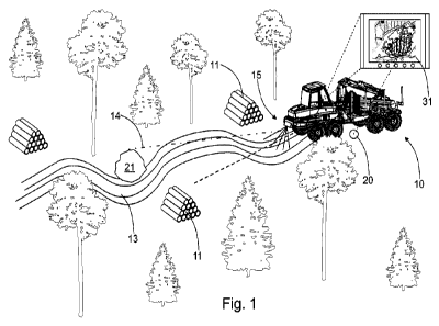
Figure 1 shows a forest machine 10, which is used to collect the
trees previously felled and cut by a harvester. Generally, the
trees are cut into stacks 11 by timber grade, or at least into
separate grab piles. It is then as easy as possible for the forest
machine's driver to find the trees on the ground. At the same time,
the mixing of different timber grades with each other is avoided.
The forest machine can be driven in both directions, as the
driver's seat can also be rotated. To aid the driver, there is
nowadays usually also a camera in addition to mirrors. Accessories
warning of obstacles are also used. In some cases, in thinning
the driver has his back facing the driving direction when making
a load. The forest machine is then driven on the basis of the
camera, which is difficult and slow. At the same time, trees left
standing can easily be knocked. Alternatively, the driver must
turn his seat while moving the forest machine, which further slows
work. Figure 1 shows thinning felling, in which some trees are
left to grow. The forest machine's route then winds about, taking
into account the ground and the remaining trees. In this sit-
uation, the forest machine's driver usually has his back to the
driving direction and is looking at the load space, to load as
efficiently as possible.
The invention relates to a method in a forest machine. In the
method, the forest machine's 10 surroundings are observed. In
addition, the observations are collected to form a database 12
of the surroundings (Figure 4) and the database is utilized in
the operation of the forest machine 10. In the invention, ob-
servations of a limited area are used. The number of observations
is then limited, and thus little processing capacity is required.
In addition, the database 12 is formed in real time in the forest
machine 10. Firstly, the existing equipment in the forest machine
can be used for processing and secondly there is no delay in
forming the database. The method can then be applied without
investing in equipment and external apparatuses. Further, a view
CA 03147842 2022-2-11
WO 2021/028622
PCT/F12020/050529
4
19 is formed from the database 12 of selected observations, from
which a track 13 in the surroundings is recognized. A view can
be formed simply from the observation data, from which the track
can be recognized by software means. Though the apparatus observes
the entire surroundings, the number of observations remains
limited by selecting only observations from a limited area. In
addition, the forest machine 10 is oriented in the direction of
the track 13, once the direction of travel 14 of the forest machine
relative to the recognized track 13 has been detected. Here
10 the direction of travel refers to the straight line along which
the forest machine would move, if the steering wheel was not moved.
The forest machine can move forward or back along this line, but
information on the direction of travel can be defined from the
system in the forest machine. In Figure 1, the forest machine's
10 direction of travel 14 (dot-and-dash line) differs from the
track's 13 direction (broken line), which is detected by the
method the forest machine 10 then being steered in the direction
of the track 13. In other words, the system controls the forest
machine on the basis of the database.
The level of control can be selected in the system. According to
the invention, when steering, the forest machine 10 is controlled
automatically, semi-automatically, or with assistance, based on
the database. In automatic control, the driver trusts the system,
which controls the forest machine entirely on the basis of the
database. The driver can then concentrate on operating the loader.
In semi-automatic control, the system starts steering, but the
real steering movement is made by the driver. From even a small
steering movement the driver feels the direction in which the
system would have steered. In assisted control, the system
proposes a suitable steering direction, for example by an arrow
in the display of the data system belonging to the system, or by
nudging the controls, or some other haptic feedback through the
controls. After receiving assistance from the control, the driver
CA 03147842 2022-2-11
WO 2021/028622
PCT/F12020/050529
decides on the progress of the forest machine. In other words,
the driver decides when and at what speed the forest machine will
move.
5 Even control by, or assistance by the system will significantly
facilitate the driver's work. The driver can trustingly proceed
along the track without actually steering himself. Tree damage
and other known drawbacks can then be avoided. According to the
invention, in addition to steering, the forest machine 10 can be
driven automatically, semi-automatically, or with assistance. In
automatic driving, the system determines the speed of the forest
machine according to the situation. In semi-automatic driving,
the system either slightly accelerates or slows the forest machine
to control driving. In assisted driving, for example if the system
detects the next stack being far away or the stack's position being
already in the system, the system proposes acceleration. The
driver can then accelerate the forest machine to the next stack.
As in steering, the system can guide the driver to accelerate or
slow by showing a suitable signal in the display. The driver can
preferably choose how the system controls steering and driving.
The driver can then select the level of automation according to
the situation. However, in every situation, collisions with trees
left to grow and other obstacles are avoided. In other ways too
possible problematic situations can be forecast. Generally, when
the last load is lifted from the stack and it is wished to move
the forest machine, the driver only has to open the grab enough
for the trees to be taken into the load in the load space. This
avoids the hoist and grab swaying when the forest machine is driven
to the next stack. Excess movements and swaying stress the forest
machine.
In the invention, the surroundings are observed using one or more
sensors 15, from whose measurement data a 3D point cloud of the
surroundings is formed. The system can utilize the 3D point cloud
CA 03147842 2022-2-11
WO 2021/028622
PCT/F12020/050529
6
directly, but the 3D point cloud can also be shown as a visual
view, which assists the forest machine's driver in his work. One
or more of the following devices are used as sensors: a camera
16, radar 17, or lidar 18. Information will then be sufficient
to form a precise and reliable database. Figure 2a shows the raw
data collected by lidar. The raw data is an innumerable number
of measurements and measurement points, from which a point cloud
is formed. The point cloud obtained is processed according to the
intended purpose, such as, for example, to be visualized to form
a view (Figure 2b), or then to be processed to form a set of tree
maps. For example, by pointing the devices downwards a view 19
is obtained, from which the track 13 can be reliably recognized
(Figure 2b). In addition, the area being observed can be limited,
keeping the amount of information to be processed small. In other
words, the observations of the limited area are used in
recognition. For example, only a specific sector in front of the
forest machine is observed. The forest machine's data-processing
capacity will then be sufficient and there will be as little delay
as possible in forming a database. One example of a suitable lidar
is the laser observation device marketed by the manufacture
Velodyne under the product name VLP-16, which can measure up to
600 000 points a second.
Not only the track, but also the ground and trees are recognized
from the view 19, more generally from the database. Thus, a record
of the stand to be cut remains for later use. The view 19 is
preferably recorded and attached to a map program in the forest
machine 10. The view can then be utilized the next time when the
previous track can be exploited.
The entire surroundings can be observed using other equipment in
the forest machine, so that the trees and ground can also be
observed, as stated above. The observation of the track, which
is essential for steering, can be made from a limited, i.e. smaller
CA 03147842 2022-2-11
WO 2021/028622
PCT/F12020/050529
7
amount of data, so that processing will be local and in real time.
In addition, a view is formed from the database, from which
primarily the track is recognized, as are various other things.
By using observations of a limited area, the amount of data to
be processed remains reasonable. Thus, processing can be done in
the forest machine and preferably also in real time. This avoids
delays in processing and data transmission when the steering of
the forest machine will be correctly timed and sufficiently
precise for the forest machine to be sure to stay on the track.
Non-positionality also prevents the accumulation of errors, as
the track is followed in real time on real ground. The view formed
is also simple, but the track can be recognized sufficiently
reliably and rapidly using present technology. During transfers
the driver drives the forest machine normally, but when the stand
is reached the driver guides the forest machine to the start of
the track, when the system detects the track and as the trip
progresses it steers the machine to remain on the track, while
the driver concentrates on operating the hoist.
Position is also important in recording. In other words, it is
necessary to know the real position of the recorded database or
the view formed from it. In the area of the stand a mobile or GPS
connection may not be available when positioning will fail. In
the invention, a known starting point 20 is thus sought before
observation, to position the forest machine 10 (Figure 1). In
practice, a network connection can generally be still found on
the forest track, but farther into the forest connections are not
available. On the other hand, the starting point can be defined
from a known point included in the recorded map, the precise
co-ordinates of which are known. The known position is then
defined in the map program or the position is defined from some
known position, which is attached to the map program. The po-
sitioning of, and/or at least a definition of the position of the
starting point of the map is always sought to be made primarily
CA 03147842 2022-2-11
WO 2021/028622
PCT/F12020/050529
8
using GPS or some other known satellite positioning, such as
Glonass, Galileo, Beidou, IRNSS, or QZSS.
Once the starting point 20 has been sought, the view 19 is attached
to the map program stored in the forest machine 10, so as to
position the forest machine 10 without a network connection. The
position of the forest machine will then be known even without
a positioning connection. In addition, after seeking the said
starting point 20 the view 19 is updated by recording part of the
view 19 as known to position the forest machine 10 without a
network connection. Figure 1 shows the map program, to which the
starting point 20 is connected, instead of the view. Thus, the
position remains known, when the real view is attached as part
of the map program. Preferably the obstacles 21 on, or near the
track 13 are also defined in the observation. Problems can then
be avoided beforehand. Large stones may have rolled onto the track
after the harvester, or a large tree may have fallen across the
track. Now the system can also be used to detect obstacles. Further
the system can be developed by connecting to observation machine
learning, which is arranged to decide whether to go around the
detected obstacle 21, or what should be done after detecting an
obstacle. Previous going around or over an obstacle remains in
the memory and the stored data can be utilized in future op-
erations. For example, there is reason to indicate to take care
at a previous very deep part of the track, or even to bypass the
point in question.
By means of the method and system according to the invention,
particularly the productivity of a forest machine can be sig-
nificantly raised, and better quality can be achieved in thinning,
when the trees left standing are not damaged. By installing a laser
scanner or a distance camera in the front or rear of the forest
machine, track data can be formed in the forest machine, based
on which the automation can be arranged to steer and even drive
CA 03147842 2022-2-11
WO 2021/028622
PCT/F12020/050529
9
the forest machine. Driving can be done by the driver or the
automation, after which the driver can concentrate on only
collecting trees while the automation takes care of steering and
driving.
As not only the ground but also the trees are observed, the system
can also be utilized in group felling and thinning. The driving
and steering automation can be programmed so that large stones
and stumps are not driven over, instead the system seeks the best
route from the track, for example, in terms of speed, length of
trip, or fuel consumption.
In the invention, the forest machine is steered along an observed
track. Observation and steering are preferably done automati-
cally, making steering movements by the driver unnecessary. It
is enough for the driver to define speed according to the
situation. For example, the forest machine can be driven between
small stacks without stopping and stopped only at larger stacks.
When starting again, acceleration is enough while the system
steers the forest machine along the track. A known camera view
can still support the driver to ensure staying on the track, but
the system, however, actively steers the forest machine.
The system can also be arranged to drive the forest machine
automatically. In other words, the system determines when the
forest machine will move and at what speed. For example, when the
hoist is moving the system slows down and when lifting a heavy
load, it stops the forest machine. At the same time, the system
observes the track and guides the forest machine to stay on the
track. At a large stack, where trees must be lifted more than once,
the system can be instructed to await starting. The control can
be the single press of a button in the hoist's controls, or a
specific function when operating the hoist, from which the system
recognizes the next lifting coming from the same stack. If point
CA 03147842 2022-2-11
WO 2021/028622
PCT/F12020/050529
control is being used, the system recognizes the situation when
the grab is being taken to the same stack by point control. The
system then keeps the forest machine stationary. After, or even
during the last lifting, the driver can press a specific button
5 or carry out a pre-defined operation, from which the system knows
to move the forest machine forward. The operation activating
starting can be, for example, an extended opening of the grab or
the rotation of the opened grab over a pre-set rotation-angle
limit.
The system includes one or more sensors 15 arranged to observe
the forest machine's 10 surroundings. In addition, the system
includes a database 12 for collecting observations of the
surroundings. According to the method, the system includes means
34 for detecting a previous track 13 in the surroundings and the
forest machine's 10 direction of travel 14 on the basis of a view
formed from the database 12, as well as for steering the forest
machine 10 in the direction of the track 13, once the forest
machine's 10 direction of travel 14 relative to the detected track
13 has been recognized.
Nowadays in a forest machine there is a map program as part of
the data system 22, in which the database 12 is arranged. The
observation means, such as the sensor 15, are connected to the
data system and are set to control the necessary operating
devices, such as the control means 23 and/or driving means 24.
In other ways too the driver's commands are transmitted as
electrical pre-control to the hydraulic operating devices. For
example, even one hydraulic cylinder, by which the mutual angle
of the forest machine's chassis is altered, is enough to steer
the forest machine. The adding of driving to steering already
demands more signals, but these too are of a limited number. At
the same time, for example economical acceleration ramps can be
defined in the system, by which the forest machine's starting is
CA 03147842 2022-2-11
WO 2021/028622
PC T/FI2020/050529
11
as rapid as possible, but nevertheless economical. Observation
of the ground and surroundings can affect the acceleration ramp.
On an even and straight track acceleration can even be sharp, but
when approaching a curve, hill, or other obstacle acceleration
is more gentle. On the other hand, if the driver is already
preparing for the next lifting, speed is sought to be kept even,
to avoid stops. Repeated acceleration and slowing are then
avoided, so that progress is economical. At the same time, strain
on the driver and the hoist too is reduced.
The observation means, more specifically the sensors, can include
various devices by which the ground can be observed with suf-
ficient precision. For example, by combining the image material
of a 360-camera a 3D model can be formed, from which the track
can be observed. Correspondingly, it is possible to obtain a 3D
point cloud, from which the shapes of the ground such as tracks
can be observed, directly from radar and lidar imaging. Ob-
servation is preferably combined with the map program of the
forest machine's data system, when the real position of the forest
machine can be defined on the basis of the map program and
real-time observation, even though a GPS signal is unavailable.
Miniature flying devices, such as drones, can also be utilized
to observe the surroundings.
Figure 3 shows a forest machine 10, which includes a front chassis
25 and a rear chassis 26. The front chassis 25 has an engine and
a cab 27. Correspondingly, the rear chassis 26 has a load space
28 and a hoist 29. The front chassis 25 and the rear chassis 26
are pivoted to each other and the chassis' mutual angle of rotation
is altered by means of one or more hydraulic cylinders 30, which
are part of the steering means 23. One part of the system is a
display device 31, which is located in the cab 27. The display
31 is connected to the data system 22, which controls and monitors
the forest machine and its operating devices. The necessary
CA 03147842 2022-2-11
WO 2021/028622
PCT/F12020/050529
12
sensors, database, and accessories are connected to the data
system. In Figure 3 a camera 16, radar 17, and lidar 18 are
connected to the system. Here the sensors are located in the front
chassis, but they can equally well also be located in the rear
chassis. For example, the angle between the forest machine's front
and rear chassis is detected by sensors, such as an inertia
measurement unit, based on which the control system detects the
angle and permits chassis-steering of the forest machine.
Figure 4 shows a schematic example of the system. Here the data
system 22, including the display 31, contains all the means needed
for collecting and processing data and further for operating the
operating devices and thus for steering and driving the forest
machine, according to the method. Here the radar 17 is connected
directly to the data system 22, but it is also possible to utilize
observation means connected to the machine-control system, such
as a 360-camera. In the embodiment shown, the system controls a
valve 32, which is linked to two cross-connected hydraulic
cylinders 30. In the forest-machine embodiment the hydraulic
cylinders are fitted on both sides of the chassis pivot. When
steering the forest machine, the working movements of both
hydraulic cylinders are equal in magnitude but opposite in
direction. Thus, the forest machine can be steered using a single
valve. Correspondingly, for driving a servo motor 33 is connected
here to the system. The servo motor can be arranged to operate
the accelerator pedal, or directly the feed-pump's regulator.
Alternatively, the control data is transmitted directly elec-
trically to the machine-control system. In a modern forest machine
equipped with various observation means the functionality of the
method can be obtained by means of software. The method then
becomes available through a software update.
CA 03147842 2022-2-11