Note: Descriptions are shown in the official language in which they were submitted.
CA 03149118 2022-01-28
1
DESCRIPTION
Method for determining constraints of a non-geostationary system with
respect to another non-geostationary system
[0001] The invention relates to a method for determining operational
constraints to be
observed for a first constellation of non-geostationary satellites
transmitting towards a
terrestrial station at a point on the Earth with respect to a second
constellation of non-
geostationary satellites linked with the same terrestrial station. This method
also makes it
possible to determine the operational constraints to be observed for a first
terrestrial station
linked with a first constellation of non-geostationary satellites transmitting
towards a
satellite belonging to a second constellation of non-geostationary satellites
and linked with a
second terrestrial station at a point on the Earth.
[0002] The international regulations require the different non-geostationary
systems to be
coordinated in order to avoid interfering with one another. This coordination
is generally
reflected by the definition and the setting up of acceptable levels of
interference and by
operational constraints which can lead to a reduction of capacity of certain
systems.
[0003] The need for coordination is a genuine constraint because it demands
the protection
of and/or protection from all the types of stations of the other
constellations over the
service zones of these other constellations, if the zones are known, even to
protect or be
protected for all the points on the Earth, without knowing the direction in
which the
terminal that is victim of an interference is aiming.
[0004] [Fig. 1] represents a diagram of the existing solutions for
coordinating non-
geostationary systems. A satellite NGS01 of a first non-geostationary
constellation CONS1 is
linked with a terrestrial station Si at a point on the Earth. A topocentric
angle 8 is defined
between the satellite NGS01, the terrestrial station Si and a satellite NGS02
of a second
non-geostationary constellation CONS2. The satellite NGS02 will be able to
transmit towards
the terrestrial station Si only if the topocentric angle 8 is greater than a
predetermined
angle, for example equal to 100
.
[0005] This condition on the topocentric angle imposes strong constraints on
the interfering
constellation CONS2, which are greater than the needs of the system suffering
the
Date Recue/Date Received 2022-01-28
CA 03149118 2022-01-28
2
interferences from the constellation CONS2, this system comprising the first
constellation
CONS1 and the terrestrial station Si. These constraints are therefore fairly
strict and
inflexible.
[0006] Furthermore, that requires a large number of operational constraints to
be taken into
account by the operational module managing the radio resources.
[0007] The invention aims to remedy the abovementioned drawbacks of the prior
art, more
particularly it aims to propose a method for determining operational
constraints for a first
constellation of non-geostationary satellites transmitting towards a
terrestrial station linked
with a second constellation of non-geostationary satellites. It aims also to
propose a method
for determining operational constraints for a first terrestrial station
transmitting towards a
non-geostationary satellite of a constellation of non-geostationary satellites
linked with a
second terrestrial station. The method according to the invention notably
makes it possible
to adapt the topocentric angle threshold below which the transmission from the
satellites of
the first constellation or from the first terrestrial station is prohibited,
and thus obtain
constraints that fit a precise operational situation.
[0008] One object of the invention is therefore a method, implemented by
computer, for
determining operational constraints to be observed for a first constellation
of non-
geostationary satellites transmitting towards a terrestrial station at a point
on the Earth with
respect to a second constellation of non-geostationary satellites linked with
the terrestrial
station, the operational constraints comprising at least a maximum
transmission power of
the satellites of the first constellation, the method comprising the steps of:
- determining triplets of limit values of two angles and of an interference-to-
noise ratio, the
two angles defining a position of a satellite of the first constellation
relative to an axis
formed by the terrestrial station and a satellite of the second constellation
and the
interference-to-noise ratio being the ratio between the interferences
transmitted by the first
constellation on a link between the terrestrial station and the satellite of
the second
constellation and the noise of the link, the determination of the triplets
being performed in
such a way that a distribution of signal-to-noise and interference ratios
aggregated over a
time interval is greater than a reference distribution, the signal-to-noise
and interference
ratios being the ratios between a useful signal of the link and the noise and
the
interferences;
Date Recue/Date Received 2022-01-28
CA 03149118 2022-01-28
3
- determining at least the maximum transmission power of at least one
satellite of the first
constellation from the triplets of values.
[0009] According to embodiments:
- the triplets of limit values are determined by the following steps:
1) selecting, for each instant of a time interval, satellites of the first
constellation and a
satellite of the second constellation and determining, for each instant of the
time interval, a
triplet of angle values defining a position of the selected satellites of the
first constellation
with respect to an axis formed by the terrestrial station and the selected
satellite of the
second constellation and of signal-to-noise and interference ratio, the signal-
to-noise and
interference ratio being the signal-to-noise and interference ratio of the
selected satellites of
the first constellation with respect to the link between the terrestrial
station and the
selected satellite of the second constellation;
2) determining the instants of the time interval and adjusting the signal-to-
noise and
interference ratio value of the triplet of these instants in such a way that a
distribution of the
signal-to-noise and interference ratios aggregated over the time interval is
greater than a
reference distribution;
3) determining triplets of values at the determined instants and a surface
equation
parameterized by the triplets, the triplets of values (8, cp, I/N) being the
angles (8, cp)
defining the position of a selected satellite of the first constellation and
I/N being an
interference-to-noise ratio on the link determined by the adjusted signal-to-
noise and
interference ratios, the points of this surface equation representing the
triplets of limit
values (8, cp, I/N).
- The selection of the satellites in the step 1) is done so as to minimize
a signal-to-noise and
interference ratio on a link between the terrestrial station and a satellite
of the second
constellation.
- The method comprises the following steps performed after the step 3):
4) for each instant of the time interval and for a satellite of the second
constellation linked
with the terrestrial station, selecting satellites of the first constellation
that have angle
values and an interference-to-noise ratio on the link between the terrestrial
station and the
satellite of the second constellation, such that, for these angle values, the
interference-to-
Date Recue/Date Received 2022-01-28
CA 03149118 2022-01-28
4
noise ratio is less than or equal to the interference-to-noise ratio obtained
by the surface
equation for these same angle values;
5) determining the instants of the time interval and adjusting the signal-to-
noise and
interference ratio value of the selected satellites of the first constellation
for these instants
so as to minimize the difference between a distribution of the signal-to-noise
and
interference ratios aggregated over the time interval of the selected
satellites and a
reference distribution, the distribution of the aggregate signal-to-noise and
interference
ratios being greater than the reference distribution;
6) determining a second surface equation parameterized by the angle and
interference-to-
noise ratio values adjusted from the adjusted signal-to-noise and interference
ratios of the
selected satellites at the instants determined in the step 5), the points of
this second surface
equation representing the triplets of the limit values (8, cp, I/N).
- The method comprises the following steps performed after the step 3):
3') determining the angle values defining the position of a satellite of the
first constellation
transmitting towards the terrestrial station linked with a satellite of the
second constellation
and the interference-to-noise ratio of the satellite of the first
constellation on the link
between the terrestrial station and the satellite of the second constellation;
3") comparing the interference-to-noise ratio to the interference-to-noise
ratio determined
by the surface equation for the angle values determined in 3'), so that:
- if the interference-to-noise ratio is less than or equal to that
determined by the surface
equation, retaining or increasing the transmission power of the satellite of
the first
constellation so that its interference-to-noise ratio remains lower than that
of the surface
equation;
- if the interference-to-noise ratio is greater than that obtained with the
surface equation,
reducing the transmission power of the satellite of the first constellation so
that its
interference-to-noise ratio is greater than or equal to that of the surface
equation.
- The method is implemented for a plurality of assumed positions of
terrestrial stations.
- The satellites of the first constellation and the satellite of the second
constellation selected
in the step 1) are those that minimize the value of an angle defining the
position of the
Date Recue/Date Received 2022-01-28
CA 03149118 2022-01-28
satellites of the first constellation relative to the axis formed between the
terrestrial station
and a satellite of the second constellation.
[0010] Another object of the invention is a method, implemented by computer,
for
determining operational constraints to be observed for a first terrestrial
station at a point on
the Earth, transmitting towards a non-geostationary satellite of a
constellation of non-
geostationary satellites linked with a second terrestrial station with respect
to the link
between the satellite and the second terrestrial station, the operational
constraints
comprising at least a maximum transmission power of the first terrestrial
station, the
method comprising the steps of:
- determining triplets of limit values (8, cp, I/N) of two angles and of an
interference-to-noise
ratio, the two angles defining a position of the first terrestrial station
relative to an axis
formed by the second terrestrial station and the non-geostationary satellite
and the
interference-to-noise ratio being the ratio between interferences transmitted
by the first
terrestrial station on the link between the second terrestrial station and the
non-
geostationary satellite and the noise of the link, the determination of the
triplets being
performed in such a way that a distribution of signal-to-noise and
interference ratios
aggregated over a time interval is greater than a reference distribution, the
signal-to-noise
and interference ratios being the ratios between a useful signal of the link
and the noise and
the interferences;
- determining at least the maximum transmission power of the first
terrestrial station from
the triplets of values.
[0011] According to embodiments:
- the triplets of limit values (8, cp, I/N) are determined by the following
steps:
1) selecting, for each instant of a time interval, first terrestrial stations
and a non-
geostationary satellite linked with the second terrestrial station, and
determining, for each
instant of the time interval, a triplet of angle values defining a position of
the first terrestrial
stations selected relative to an axis formed by the second terrestrial station
and the non-
geostationary satellite and the signal-to-noise and interference ratio, the
signal-to-noise and
interference ratio being the signal-to-noise and interference ratio of the
first stations
Date Recue/Date Received 2022-01-28
CA 03149118 2022-01-28
6
selected with respect to the link between the second terrestrial station and
the non-
geostationary satellite;
2) determining the instants of the time interval and adjusting the signal-to-
noise and
interference ratio value of the triplet of these instants so that a
distribution of the signal-to-
noise and interference ratios aggregated over the time interval is greater
than a reference
distribution;
3) determining triplets of values (8, cp, I/N) at the determined instants and
a surface
equation parameterized by the triplets (8, cp, I/N), the triplets of values
being the angles
defining the position of the first terrestrial stations selected relative to
the axis formed by
the second terrestrial station and the non-geostationary satellite and I/N
being an
interference-to-noise ratio on the link between the second terrestrial station
and the non-
geostationary satellite determined by the adjusted signal-to-noise and
interference ratios,
the points of this surface equation representing the triplets of limit values
(8, cp, I/N).
- The selection of the terrestrial stations and of the non-geostationary
satellite in the step 1)
is performed so as to minimize a signal-to-noise and interference ratio on a
link between the
second terrestrial station and the selected non-geostationary satellite.
- The method comprises the following steps performed after the step 3):
4) for each instant of the time interval and for the second terrestrial
station, selecting first
terrestrial stations at points on the Earth and a non-geostationary satellite
linked with the
second terrestrial station, such that the first terrestrial stations have
angle values and an
interference-to-noise ratio on the link between the second terrestrial station
and the non-
geostationary satellite, and that, for these angle values, the interference-to-
noise ratio is less
than or equal to the interference-to-noise ratio obtained by the surface
equation for these
same angle values;
5) determining the instants of the time interval and adjusting the signal-to-
noise and
interference ratio value of the first terrestrial stations selected for these
instants, so as to
minimize the difference between a distribution of the signal-to-noise and
interference ratios
aggregated over the time interval of the first selected stations and a
reference distribution,
the distribution of the aggregate signal-to-noise and interference ratios
being greater than
the reference distribution;
Date Recue/Date Received 2022-01-28
CA 03149118 2022-01-28
7
6) determining a second surface equation parameterized by the angle and
interference-to-
noise ratio values adjusted on the basis of the adjusted signal-to-noise and
interference
ratios of the first terrestrial stations selected at the instants determined
in the step 5), the
points of this second surface equation representing the triplets of limit
values (8, cp, I/N).
- The method comprises the following steps performed after the step 3):
3') determining the angle values defining the position of a first terrestrial
station
transmitting towards a non-geostationary satellite with the second terrestrial
station and
the interference-to-noise ratio of the first terrestrial station on the link
between the second
terrestrial station and the non-geostationary satellite;
3") comparing the interference-to-noise ratio to the interference-to-noise
ratio determined
by the surface equation for the angle values determined in 3'), so that:
- if the interference-to-noise ratio is less than or equal to that
determined by the surface
equation, retaining or increasing the transmission power of the first
terrestrial station so
that its interference-to-noise ratio remains lower than that of the surface
equation;
- if the interference-to-noise ratio is greater than that obtained with the
surface equation,
reducing the transmission power of the first terrestrial station so that its
interference-to-
noise ratio is greater than or equal to that of the surface equation;
- The method is implemented for a plurality of assumed positions of the
second terrestrial
station.
- The first terrestrial stations and the non-geostationary satellite
selected in the step 1) are
those minimizing an angle value defining the position of the first terrestrial
stations relative
to an axis formed by the second terrestrial station and the selected non-
geostationary
satellite.
[0012] Another object of the invention is a computer program comprising
instructions for
executing the method for determining triplets of limit values (8, cp, I/N)
according to the
invention, when the program is run by a processor.
[0013] Yet another object of the invention is a processor-readable storage
medium, on
which is stored a program comprising instructions for executing the method for
determining
Date Recue/Date Received 2022-01-28
CA 03149118 2022-01-28
8
triplets of limit values (8, cp, I/N) according to the invention; when the
program is run by a
processor.
[0014] Other features, details and advantages of the invention will emerge on
reading the
description given with reference to attached figures which are given by way of
example and
which represent, respectively:
[0015] [Fig. 1], already described, a diagram representing the current
constraints of the
constellations of non-geostationary satellites with respect to another non-
geostationary
system according to the prior art;
[0016] [Fig. 2a] and [Fig. 2b], two diagrams of the principle of the method
according
to the invention for two application cases;
[0017]
[Fig. 3], a diagram of the steps of the method according to a first
embodiment;
[0018] [Fig. 4], a diagram of the steps of the method according to a second
embodiment;
[0019] [Fig. 5] and [Fig. 6], two figures representing the principle of the
step 2) of the
method according to the invention; and
[0020]
[Fig. 7], a figure representing a surface equation obtained by the method
according to the
invention.
[0021] [Fig. 2a] represents a diagram of the principle of the method according
to the
invention in a first application case. This first application case represents
a downlink. A
constellation CONS_V, comprising several satellites situated on a non-
geostationary orbit
and comprising means capable of communicating with one or more terrestrial
stations,
comprises a non-geostationary satellite NGSO_V linked with a terrestrial
station SV situated
at a point on the Earth. The satellite NGSO_V therefore sends and/or receives
signals C that
are called useful to the terrestrial station SV.
[0022] Another constellation CONS _I comprises a non-geostationary satellite
NGS0_1
transmitting signals Ito the terrestrial station SV. These signals can
interfere with the link
between the terrestrial station SV and the victim satellite NGSO_V and
constitute a source of
interference for this link. The constellation CONS_V and the satellite NGSO_V
suffering these
Date Recue/Date Received 2022-01-28
CA 03149118 2022-01-28
9
interferences are denoted victim constellation and victim satellite
hereinafter in the
description.
[0023] The topocentric angle 8 is defined as the angle formed between the
satellite NGSO_V
and the satellite NGSO_Ifrom the terrestrial station SV, and the elevation
angle cp is defined
as the angle formed between the plane TAN tangential to the ground at the
terrestrial
station SV and the axis formed by the terrestrial station SV and the satellite
NGS0_1. These
two angles 8 and cp make it possible to define a position of the satellite
NGS0_1 relative to
the satellite NGSO_V and to the station SV.
[0024] The objective of the method is to define the maximum power value of the
interference signal I that the satellite NGS0_1 can transmit to the station SV
for a topocentric
angle value 8 and an elevation angle value cp that are fixed, by generating an
acceptable
level of interferences with respect to the constellation CONS_V. In other
words, the
objective of the method is to determine a maximum power for each satellite
NGS0_1 of the
constellation CONS_I by taking account of the possible interferences generated
with respect
to the satellites NGSO_V of another constellation CONS_V situated in its
vicinity. For that,
triplets of limit values (8, cp, R) of a topocentric angle 8, of an elevation
angle cp and of a
signal-to-noise and interference ratio R are determined in such a way that a
distribution of
signal-to-noise and interference ratios R aggregated over a time interval is
greater than a
reference distribution REF.
[0025] The signal-to-noise and interference ratio R is the ratio between a
useful signal C of
the link between the terrestrial station SV and the satellite NGSO_V of the
victim
constellation CONS_V and the noise N and the interferences I transmitted by
the
interference constellation CONS_I on this link. In other words, the signal-to-
noise and
interference ratio R is equal to CAN+I).
[0026] From the signal-to-noise and interference ratio R, it is possible to
deduce the
maximum transmission power of a satellite NGS0_1 of the interfering
constellation CONS_I
from the determined triplets of values and using theoretical relationships
known from the
field. More particularly, it is possible to determine, for a given topocentric
angle value 8 and
a given elevation angle value cp, the maximum transmission power from the
signal-to-noise
and interference ratio of the triplet of values comprising the given angle
values.
Date Recue/Date Received 2022-01-28
CA 03149118 2022-01-28
[0027] [Fig. 2b] represents a diagram of the principle of the method according
to the
invention in a second application case, representing an uplink. A
constellation CONS_V,
comprising several satellites situated on a non-geostationary orbit and
comprising means
capable of communicating with one or more terrestrial stations, comprises a
non-
geostationary satellite NGSO_V linked with a terrestrial station SV situated
at a point on the
Earth. The satellite NGSO_V therefore sends and/or receives signals C that are
called useful
to the terrestrial station SV.
[0028] Another terrestrial station SI, called interfering station, is linked
with a second
constellation CONS_I of non-geostationary satellites, notably with a non-
geostationary
satellite NGS0_1. This other terrestrial station SI also transmits signals Ito
the satellite
NGSO_V linked with the terrestrial station SV. These signals I can interfere
with the link
between the terrestrial station SV and the satellite NGSO_V, called victim,
and constitute a
source of interference for this link.
[0029] In order to identify the position of the interfering terrestrial
station SI, an angle 8
formed between the station SV and the interfering station SI is defined from
the victim non-
geostationary satellite NGSO_V, and an angle of elevation cp is defined as the
angle formed
between the plane TAN tangential to the orbit of the victim constellation
CONS_V and to the
satellite NGSO_V and the axis formed by the interfering terrestrial station SI
and the satellite
NGSO_V. These two angles 8 and cp make it possible to define the position of
the station SI
relative to the satellite NGSO_V and to the station SV.
[0030] The objective of the method, for this second application case, is to
define the
maximum power value of the interfering signal I that the station SI can
transmit to the
satellite NGSO_V for an angle value 8 and an angle value cp that are fixed, by
generating an
acceptable level of interference with respect to the constellation CONS_V. In
other words,
the objective of the method is to determine a maximum power for each
terrestrial station SI
by taking account of the possible interferences generated with respect to
satellite NGSO_V
of a constellation CONS_V linked with a terrestrial station SV situated in its
vicinity. For that,
triplets of limit values (8, cp, R) of the angles 8, cp and of a signal-to-
noise and interference
ratio R are determined so that a distribution of signal-to-noise and
interference ratios R
aggregated over a time interval is greater than a reference distribution REF.
Date Recue/Date Received 2022-01-28
CA 03149118 2022-01-28
11
[0031] The signal-to-noise and interference ratio R is the ratio between a
useful signal C of
the link between the terrestrial station SV and the satellite NGSO_V of the
victim
constellation CONS_V and the noise N and the interferences I transmitted by
the interfering
station SI on this link. In other words, the signal-to-noise and interference
ratio R is equal to
C/(N+I).
[0032] From the signal-to-noise and interference ratio R, it is possible to
deduce the
maximum transmission power of the station SI from the triplets of values
determined and
using theoretical relationships known in the field. More particularly, it is
possible to
determine, for given angle values 8 and cp, the maximum transmission power
from the
signal-to-noise and interference ratio of the triplet of values comprising the
given angle
values.
[0033] [Fig. 3] presents a diagram of the steps of the method according to a
first
embodiment. The first application case (figure 2a) is taken for the
description of figures 3
to 7.
[0034] In a first step 201, for each instant of a time interval and for a
terrestrial station SV at
a point on the Earth, satellites of the interfering constellation CONS_I and a
satellite NGSO_V
of the victim constellation CONS_V are selected according to a selection
criterion. In the
example described, the satellites of the interfering constellation CONS_I and
a satellite
NGSO_V are selected which minimize the signal-to-noise and interference ratio
R on the link
between the terrestrial station SV and the satellite of the victim
constellation CONS_V.
However, it is also possible to select the satellite NGSO_V of the victim
constellation that has
the highest elevation in this constellation with respect to the terrestrial
station SV. It is also
possible to select an interfering satellite CONS_I that has the longest time
of visibility with
respect to the terrestrial station SV and/or a particular satellite of the
victim constellation
CONS_V.
[0035] Then, for these same instants, a triplet of values (8, cp, R) of
topocentric angle 8, of
elevation angle cp and of signal-to-noise and interference ratio R is
determined for these
selected satellites relative to the terrestrial station SV. The topocentric
angle 8 is the
minimum angle formed by the satellite NGSO_V of the victim constellation
CONS_V selected,
the terrestrial station SV and the selected satellites NGS0_1 of the
interfering constellation
CONS_I. The elevation angle cp is the minimum angle formed between the plane
TAN
Date Recue/Date Received 2022-01-28
CA 03149118 2022-01-28
12
tangential to the ground at the terrestrial station SV and the axis formed
between the
terrestrial station SV and the selected satellites NGS0_1 of the interfering
constellation
CONS_I. The signal-to-noise and interference ratio R is the signal-to-noise
and interference
ratio of the interfering satellites NGSO_Iof the interfering constellation
CONS_I on the link
between the terrestrial station SV and the victim satellite NGSO_V of the
victim constellation
CONS_V. This ratio R is determined by simulation.
[0036] Then, in a second step 202, a determination is made as to the instants
of the time
interval for which it is possible to adjust the signal-to-noise and
interference ratio value R of
the triplet of values (8, cp, R) of these instants so that a distribution of
the signal-to-noise and
interference ratios R aggregated over the time interval is greater than the
reference
distribution REF.
[0037] [Fig. 5] and [Fig. 6] illustrate the step 202 of the method.
[0038] Figure 5 represents the percentage of time %t of the time interval as a
function of the
signal-to-noise and interference ratio R = CAN+I). The curve REF represents
the reference
distribution and the curve Ni represents aggregate signal-to-noise and
interference ratios of
the satellites of the victim and interfering constellations selected with
respect to the
terrestrial station, whereas the curve N2 represents the same signal-to-noise
and
interference ratios after the identification of the time instants for which
the value of the
signal-to-noise and interference ratio is adjusted for the curve Ni to be
greater than the
reference distribution REF.
[0039] Figure 6 represents the signal-to-noise and interference ratio R as a
function of the
different instants t of the time interval. It is these signal-to-noise and
interference ratios
aggregated over the time interval (therefore aggregated over all the instants
t) which make
it possible to obtain the curve Ni of Figure 5. The identified time instants
INST are
represented in Figure 6 and their signal-to-noise and interference ratio value
R is modified so
as to obtain the curve N2 of Figure 5.
[0040] To determine these instants t of the time interval from Figures Sand 6,
it is assumed
that the curve Ni of Figure 5 follows a probability law as follows:
[0041]
PN1 (X xn) = pn (1)
Date Recue/Date Received 2022-01-28
CA 03149118 2022-01-28
13
[0042] in which X represents a random variable of the signal-to-noise and
interference ratio
R, xn represents a particular value of a signal-to-noise and interference
ratio, pn represents
the time probability corresponding to the signal-to-noise and interference
ratio value xn and
n is an integer less than or equal to the total number of time instants of the
time interval.
[0043] It is also assumed that the reference distribution REF follows the
following probability
law:
[0044]
PREAX x) = P (2)
[0045] with p a time probability corresponding to the signal-to-noise and
interference ratio
value x and X being a random variable representing a signal-to-noise and
interference ratio.
[0046] If the curve Ni becomes less than the reference distribution REF for
all probabilities
p, then that means that there is an integer i and m such that:
[0047]
PNi(X xi) = Pi and PREF(X > xm) = pi with xi < xm (3)
[0048] and such that:
[0049]
PN1(X xm) = Pm with pm < pi (4)
[0050] A law of the curve Ni is then sought to be obtained such that:
[0051]
PNi(X xi) = Pm (5)
[0052] The first step is to identify the greatest value of i that does not
observe the criterion
of the equation (5), which means that, for X = xi+i, the criterion will be
observed. The value xi
is then modified to become equal to xi+i, that is to say that the signal-to-
noise ratio value xi
becomes equal to
[0053] That is applied for all the other values of i that do not observe the
criterion of the
equation (5) by working through the i values in descending order.
Date Recue/Date Received 2022-01-28
CA 03149118 2022-01-28
14
[0054] That makes it possible to identify the values xi of signal-to-noise and
interference
ratios to be modified. It is now necessary to identify the time instants t
corresponding to
these values xi. For that, in Figure 6, it is possible to identify all the
signal-to-noise and
interference ratios that are equal to the identified values xi, then modify
signal-to-noise and
interference ratio values of these instants so that the distribution of the
signal-to-noise and
interference ratios R, comprising the modified values, aggregated over the
time interval, is
greater than the reference distribution REF.
[0055] In the third step 203, triplets of values (8, cp, I/N) are determined
at the instants
determined in the preceding step. The triplets of values (8, cp, I/N)
represent the angles (8,
cp) defining the position of a selected satellite NGS0_1 of the first
constellation CONS_I and
I/N being an interference-to-noise ratio on the link determined by the signal-
to-noise and
interference ratios R adjusted in the preceding step for the determined
instants.
[0056] In this step, a surface equation parameterized by the triplets of
values (8, cp, I/N) is
also determined. The points of the surface equation represent the triplets of
limit values (8,
I/N) authorized for the satellites of the interfering constellation CONS_I
with respect to
the link between the terrestrial station SV and the victim satellite NGSO_V.
[0057] In an optional fourth step 203' and an optional fifth step 203", there
will be a check
as to whether a satellite of the interfering constellation CONS_I transmitting
towards the
terrestrial station SV transmits an interference level that is sufficiently
low to preserve the
link between the terrestrial station and a non-geostationary satellite of the
victim
constellation CONS_V.
[0058] For that, in the fourth step 203', the topocentric angle 8, elevation
angle cp and
interference-to-noise ratio I/N values are determined for the satellite of the
interfering
constellation CONS_I transmitting to the terrestrial station SV linked with
the satellite of the
victim constellation CONS_V.
[0059] Then, in the next step 203", the interference-to-noise ratio I/N is
compared to the
interference-to-noise ratio determined by the surface equation of the step 203
for the angle
values 8 and cp determined previously in 203'.
[0060] If the interference-to-noise ratio is less than or equal to the ratio
determined by the
surface equation, that means that the interfering satellite interferes little
on the link
Date Recue/Date Received 2022-01-28
CA 03149118 2022-01-28
between the terrestrial station and the satellite of the victim constellation.
It is not therefore
necessary to reduce the transmission power of the interfering satellite. It
may even be
possible to increase the transmission power of the interfering satellite,
provided that the
signal-to-noise and interference ratio value remains less than the ratio
determined by the
surface equation.
[0061] If the signal-to-noise and interference ratio is greater than the ratio
determined by
the surface equation, that means that the interfering satellite interferes
with the link
between the terrestrial station and the satellite of the victim constellation.
It is therefore
necessary to reduce the transmission power of the interfering satellite so
that its signal-to-
noise and interference ratio is greater than or equal to that determined by
the surface
equation. Instead of reducing the transmission power of the interfering
satellite, it is also
possible to use another satellite of the interfering constellation CONS_I to
lower the level of
interference.
[0062] Figure 7 represents a surface equation determined in the third step 203
of the
method. The surface equation EQ_SURF depends on the two angles 8 and cp
defining the
position of a satellite of the interfering constellation relative to the link
between the
terrestrial station SV and a satellite of the victim constellation and on the
signal-to-noise and
interference ratio R defined by the ratio between the useful signal of the
link between the
terrestrial station and the satellite of the victim constellation and the sum
of the noise and
of the interferences on this link coming from the satellite of the interfering
constellation.
The angle 8 can be a topocentric angle formed between a satellite of the
interfering
constellation, the terrestrial station and a satellite of the victim
constellation, and the angle
cp can be an elevation angle formed between the plane tangential to the
terrestrial station
and the axis formed between the terrestrial station and the satellite of the
interfering
constellation.
[0063] The points of this surface equation EQ_SURF defined by a triplet of
values (8, cp, I/N)
represent, for given angle values 8 and cp, the maximum interference-to-noise
ratio I/N and
therefore the maximum level of interference that the satellite of the
interfering
constellation can have on the link.
Date Recue/Date Received 2022-01-28
CA 03149118 2022-01-28
16
[0064] [Fig. 4] represents a diagram of the steps of the method according to a
second
embodiment. The first 201, second 202 and third 203 steps are identical to the
steps 201,
202 and 203 described with reference to Figure 3.
[0065] In this second embodiment, three additional steps 204, 205 and 206 are
performed
to adjust the surface equation determined in the third step 203 to an
operational situation.
[0066] There are therefore selected, in the fourth step 204, for each instant
of the time
interval and for a satellite of the victim constellation linked with the
terrestrial station, the
satellites of the interfering constellation which have topocentric angle 8,
elevation angle cp
and interference-to-noise ratio I/N values such that, for these angle values 8
and cp, the
interference-to-noise ratio I/N is less than or equal to the interference-to-
noise ratio
determined by the surface equation of the step 203 for these same angle values
8 and cp.
[0067] Then, in the fifth step 205, a determination is made as to instants of
the time interval
for which it is possible to adjust the signal-to-noise and interference ratio
value so that the
distribution of the signal-to-noise and interference ratios aggregated over
the time interval
of the selected satellites of the interfering constellation with respect to
the link between the
terrestrial station and the satellite of the victim constellation is greater
than the reference
distribution.
[0068] Finally, in the sixth step 206, a second surface equation is determined
that is
parameterized by the angle 8 and cp values and interference-to-noise ratios
I/N adjusted
from the signal-to-noise and interference ratios, adjusted in the step 205, of
the selected
satellites at the instants determined in the preceding step. The points of
this second surface
equation represent the triplets of corrected limit values (8, cp, I/N). This
second surface
equation makes it possible to protect the two non-geostationary systems (that
comprising
the interfering constellation and that comprising the victim constellation and
the terrestrial
station) while relaxing the constraints defined by the first surface equation
and
corresponding to the worst interfering configuration between the two
constellations, while
operationally, the satellites of the two constellations can be in a more
favourable
configuration.
[0069] According to another embodiment, the method is performed for a
plurality of
terrestrial station assumptions. For that, if the method is performed for N
terrestrial stations
Date Recue/Date Received 2022-01-28
CA 03149118 2022-01-28
17
linked with a satellite of the victim constellation CONS_V, the steps 201, 202
and 203 (and
possibly the steps 203', 203", 204, 205 and 206) are repeated N times, each
repetition being
performed for a station that is different from the previous repetitions. It
will therefore be
necessary on each repetition of the step 1) to redefine the satellites of the
interfering
constellation CONS_I and the satellite of the victim constellation CONS_V for
each instant
which minimize the signal-to-noise and interference ratio on the link.
[0070] According to one embodiment, the selection of the satellites of the two
constellations with respect to the terrestrial station is made in such a way
as to select the
worst case, for example by taking the satellite, from among those minimizing
the signal-to-
noise and interference ratio, that gives the smallest topocentric angle 8.
[0071] According to another embodiment, it is also possible to determine
triplets of limit
values (8, cp, R) in which R represents the signal-to-noise and interference
ratio of the
satellites of the interfering constellation on the link between the
terrestrial station and a
satellite of the victim constellation. Thus, it is also possible to determine
a third surface
equation from these triplets of values (8, cp, R).
[0072] For that, the triplets of values (8, cp, R) deriving from the instants
determined in the
step 202 are used to parameterize a third surface equation.
[0073] However, if the surface equation parameterized by the triplets (8, cp,
R) is used, the
interfering satellites exhibiting ratio R values greater than those given by
the third surface
equation for given angle values will be sought to be selected.
[0074] For example, for the step 204, the satellites of the interfering
constellation are
selected such that, for a given topocentric angle value 8 and for an elevation
angle value cp,
the signal-to-noise and interference ratio R is greater than the ratio R
determined by the
third surface equation for these same angle values.
[0075] According to another example, for the step 203", the signal-to-noise
and interference
ratios R are compared with the ratios determined by the third surface equation
for
topocentric and elevation angle values determined in the step 203', and the
transmission
power of the satellites of the interfering constellation is reduced if the
ratio R is less than
that determined by the third surface equation.
Date Recue/Date Received 2022-01-28
CA 03149118 2022-01-28
18
[0076] Nevertheless, the use of the ratio I/N is prioritized, because the
ratio I/N is
independent of the radio frequency characteristics specific to the link
between the
terrestrial station and the satellite of the victim constellation.
[0077] The figures have been described for the first application case. It is
also possible to
apply the method for the second application case, namely for an uplink, in
which it is a
terrestrial station SI which emits interfering signals Ito the link between
the terrestrial
station SV and a satellite of the victim constellation. That corresponds to
the situation
presented in figure 2b.
[0078] In this application case, in the step 201, for each instant of a time
interval, first
terrestrial stations SI at points on the earth, different from the point of
the terrestrial station
SV, and a non-geostationary satellite of a non-geostationary constellation
linked with the
terrestrial station SV, which minimize a signal-to-noise and interference
ratio R on the link
between the terrestrial station SV and the selected non-geostationary
satellite, are selected.
There are also determined, for each instant of the time interval, a triplet
(8, cp, R) of angle
values (8, cp) defining a position of the first terrestrial stations SI
selected relative to an axis
formed by the terrestrial station SV and the non-geostationary satellite and
signal-to-noise
and interference ratio R. The ratios R being the signal-to-noise and
interference ratios of the
first stations selected with respect to the link between the terrestrial
station and the non-
geostationary satellite.
[0079] In the second step 202, the instants of the time interval are
determined and, for
these instants, the signal-to-noise and interference ratio value of the
triplet (8, cp, R) of these
instants is adjusted so that a distribution of the signal-to-noise and
interference ratios
aggregated over the time interval is greater than a reference distribution
(REF).
[0080] Then, in the step 203, triplets of values (8, cp, I/N) at the
determined instants and a
surface equation parameterized by the triplets (8, cp, I/N) are determined.
The triplets of
values (8, cp, I/N) are the angles (8, cp) defining the position of the first
terrestrial stations
selected relative to the axis formed by the second terrestrial station SV and
the non-
geostationary satellite NGSO_V and the interference-to-noise ratio I/N on the
link between
the terrestrial station SV and the non-geostationary satellite determined by
the adjusted
signal-to-noise and interference ratios (R). The points of this surface
equation represent the
triplets of limit values (8, cp, I/N).
Date Recue/Date Received 2022-01-28
CA 03149118 2022-01-28
19
[0081] In the case where the aim is to adapt to an operational situation, the
steps described
with reference to figure 4 are as follows for this application case:
[0082] In the step 204, for each instant of the time interval and for the
second terrestrial
station SV, first terrestrial stations at points on the Earth and a non-
geostationary satellite
linked with the terrestrial station SV are selected, such that the first
terrestrial stations have
angle values (8, cp) and an interference-to-noise ratio (I/N) on the link
between the
terrestrial station SV and the non-geostationary satellite of the victim
constellation, and
that, for these angle values, the interference-to-noise ratio is less than or
equal to the
interference-to-noise ratio obtained by the surface equation for these same
angle values.
[0083] Then, in the step 205, the instants of the time interval are determined
and signal-to-
noise and interference ratio value (R) of the first selected terrestrial
station for these
instants are adjusted, so as to minimize the difference between a distribution
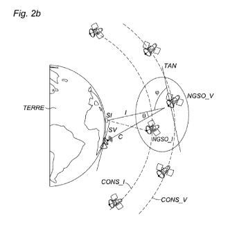
of the signal-
to-noise and interference ratios aggregated over the time interval of the
first selected
stations and a reference distribution (REF), the distribution of the aggregate
signal-to-noise
and interference ratios being greater than reference distribution.
[0084] Finally, in the step 206, a second surface equation is determined that
is
parameterized by the angle and interference-to-noise ratio values adjusted
from the
adjusted signal-to-noise and interference ratios of the first terrestrial
stations selected at the
instants determined in the step 205. The points of this second surface
equation represent
the triplets of limit values (8, cp, I/N).
[0085] For the case of figure 3, in the step 203', the angle values (8, cp)
defining the position
of a first terrestrial station transmitting toward a non-geostationary
satellite linked with the
terrestrial station SV and the interference-to-noise ratio (I/N) of the first
terrestrial station
on the link between the terrestrial station and the non-geostationary
satellite are
determined.
[0086] Then, in the step 203", the interference-to-noise ratio is compared to
the
interference-to-noise ratio determined by the surface equation for the angle
values
determined in the step 203', so as to:
Date Recue/Date Received 2022-01-28
CA 03149118 2022-01-28
- if the interference-to-noise ratio is less than or equal to that
determined by the surface
equation, retain or increase the transmission power of the first terrestrial
station so that its
interference-to-noise ratio remains less than that of the surface equation;
- if the interference-to-noise ratio is greater than that obtained with the
surface equation,
reduce the transmission power of the first terrestrial station so that its
interference-to-noise
ratio is greater than or equal to that of the surface equation.
[0087] As for the first application case, the method can be implemented for a
plurality of
assumed positions of the terrestrial station SV.
[0088] Likewise, the first terrestrial stations and the non-geostationary
satellite selected in
the step 201 can be those that minimize an angle value, for example 8,
defining the position
of the first terrestrial stations relative to an axis formed by the second
terrestrial station and
the selected non-geostationary satellite.
[0089] The method according to the invention has been described in the context
of two non-
geostationary constellations. However, the method is not limited to that, it
can also be used
in a more general context involving a non-geostationary constellation and a
geostationary
constellation. That can for example be in the case where a geostationary
constellation
(satellite of the constellation or terrestrial station linked with the
geostationary
constellation) transmits interfering signals on a link between a terrestrial
station on the
Earth and a non-geostationary constellation. That can also be in the case
where a non-
geostationary constellation (satellite of the constellation or terrestrial
station linked with the
non-geostationary constellation) transmits interfering signals on a link with
a terrestrial
station on the Earth and a geostationary constellation.
[0090] The invention can be implemented as a computer program comprising
instructions
for the execution thereof. The computer program can be stored on a processor-
readable
storage medium. The medium can be electronic, magnetic, optical or
electromagnetic.
[0091] In particular, the invention can be implemented by a device comprising
a processor
and a memory. The processor can be a generic processor, a specific processor,
an
application-specific integrated circuit (known also by the acronym ASIC) or a
field-
programmable gate array (also known by the acronym FPGA).
Date Recue/Date Received 2022-01-28
CA 03149118 2022-01-28
21
[0092] The device can use one or more dedicated electronic circuits or a
general-purpose
circuit. The technique of the invention can be produced on a reprogrammable
computation
machine (a processor or a microcontroller for example) executing a program
comprising a
sequence of instructions, or on a dedicated computation machine (for example a
set of logic
gates like an FPGA or an ASIC, or any other hardware module).
[0093] According to one embodiment, the device comprises at least one computer-
readable
storage medium (RAM, ROM, EEPROM, flash memory or another memory technology,
CD-ROM, DVD or another optical disk medium, magnetic cassette, magnetic tape,
computer-
readable permanent storage disk) coded with a computer program (that is to say
several
executable instructions) which, when it is run on a processor or several
processors, performs
the functions of the embodiments of the invention described previously.
[0094] As an example of hardware architecture suitable for implementing the
invention, a
device according to the invention can comprise a communication bus to which
there are
linked a central processing unit or microprocessor (CPU), a read-only memory
(ROM) that
can comprise the programs necessary to the implementation of the invention; a
random-
access memory or cache memory (RAM) comprising registers suitable for storing
variables
and parameters created and modified during the execution of the abovementioned
programs; and a communication or I/O (input/output) interface suitable for
transmitting and
receiving data.
[0095] The reference to a computer program which, when it is run, performs any
one of the
functions described previously, is not limited to an application program
running on a single
host computer. On the contrary, the terms computer program and software are
used here in
a general sense to refer to any type of computing code (for example,
application software,
firmware, microcode, or any other form of computer instruction) which can be
used to
program one or more processors to implement aspects of the techniques
described here.
The computing means or resources can notably be distributed ("cloud
computing"), possibly
with according to pair-to-pair technologies. The software code can be executed
on any
appropriate processor (for example, a microprocessor) or processor core or a
set of
processors, whether provided in a single computation device or distributed
between several
computation devices (for example as possibly accessible in the environment of
the device).
The executable code of each program allowing the programmable device to
implement the
Date Recue/Date Received 2022-01-28
CA 03149118 2022-01-28
22
processes according to the invention can be stored, for example, in the hard
disk or in read-
only memory. Generally, the program or programs will be able to be loaded into
one of the
storage means of the device before being executed. The central processing unit
can control
and direct the execution of the instructions or portions of software code of
the program or
programs according to the invention, instructions which are stored in the hard
disk or in the
read-only memory or else in the other abovementioned storage elements.
Date Recue/Date Received 2022-01-28