Note: Descriptions are shown in the official language in which they were submitted.
CA 03154483 2022-03-11
WO 2021/055384
PCT/US2020/050940
1
Title
Micro-Navigation For A Vehicle
(PL S-005W0)
Technical Field
The present invention generally relates to micro-navigation for a vehicle.
Background Art
Macro-navigation (traveling from an origination site to a destination site)
for
vehicles is well known. However, once a vehicle, such as a truck with cargo,
arrives
at a typically destination site like a warehouse campus, it must receive
guidance to
travel from an entrance to an ultimate terminal location such as a specific
loading
dock. Also, unmapped routes present problems for truck drivers and other types
of
shippers.
Further, certain routes may not be appropriate for a truck of a particular
size and
load.
There is a need for informing a vehicle such as a truck, micro-navigation
guidance
at a destination site.
Summary Of The Invention
The present invention provides a system and method for micro-navigation for
a mobile object.
The present invention provides navigation to destinations that are not
normally
found on maps or in navigation systems.
The present invention ensures that routes provided to operators are suitable
for
the mobile objects they are operating ¨ for example, a tractor trailer may not
be able
to drive around a building that has tight constraints in certain places, as
easily as a
VOLKSWAGON bug. This system acknowledges those differences and provides
different route choices for each.
Also, the present invention also collects the data automatically and
associates
it with mobile object configurations and stores them in databases under a
unique
CA 03154483 2022-03-11
WO 2021/055384
PCT/US2020/050940
2
Route Session name, where they are continuously compared to the route session
over
that same named route, that are taken by mobile objects of a similar
configuration
which is designated "mobile object cohorts" or "vehicle cohorts." By comparing
route execution by mobile objects traveling the same route from the same
cohort, the
present invention continually refines the routes by optimizing for desired
parameters,
such as speed, number of maneuvers, changes in gear position, etc.
One aspect of the present invention is a method for micro-navigation of a
mobile object. The method includes guiding a mobile object utilizing macro-
navigation to travel from an origination site of an entrance of a destination
site. The
method also includes activating a micro-navigation guidance protocol upon
arrival at
the entrance of the destination site. The method also includes guiding the
mobile
object using the micro-navigation guidance protocol from the entrance to a
terminal
location within the destination site.
Another aspect of the present invention is a system for micro-navigation of a
mobile object. The system comprises a database of mobile objects and ancillary
equipment or attachments, a plurality of geometric maneuvering libraries for
those
same mobile objects and ancillary equipment identifying the known capabilities
and
constraints, an end point database, a plurality of routes, a route execution
data capture
to inclusive of route traced by the mobile object, total distance traveled,
maneuvers
executed, and contemporaneous speed during all route segments, a plurality of
algorithms for translating route data into optimizable route structure tools
to create
routes that meet operator defined characteristics for complexity, duration,
distance
considering user selected mobile object and ancillary equipment intended for
route
passage, at least one user interface, and a mobile computing device with
secure active
connection to a mobile object data bus, where that data bus is capable of
delivering
signals triggered by mobile object movement, mobile object system activity,
and
operator generated mobile object responses, e.g., turning the steering wheel,
braking,
accelerating, or changes in transmission input and outputs.
Yet another aspect of the present invention is system for micro-navigation of
a
mobile object using device authentication and configurations. The system
comprises a
CA 03154483 2022-03-11
WO 2021/055384
PCT/US2020/050940
3
mobile object, a CVD, a mobile device, a server and a plurality of databases.
The
mobile object comprises an on-board computer with a memory having a vehicle
identification number (VIN), a connector plug, and an motorized engine. The
connected vehicle device (CVD) comprises a processor, a WiFi radio, a
BLUETOOTH radio, a memory, and a connector for mating with the connector plug
of the mobile object. The mobile device comprises a graphical user interface,
a
processor, a WiFi radio, a BLUETOOTH radio, and a cellular network interface.
Yet another aspect of the present invention a non-transitory computer-readable
medium that stores a program that causes a processor to perform functions for
.. instructing a mobile object for micro-navigation. The functions include
utilizing
macro-navigation to travel from an origination site of an entrance of a
destination site.
The functions also includes activating a micro-navigation guidance protocol
upon
arrival at the entrance of the destination site. The functions also includes
guiding the
mobile object using the micro-navigation guidance protocol from the entrance
to a
terminal location within the destination site.
Yet another aspect of the present invention is a system for micro-navigation
of
a vehicle. The system comprises a computing device configured to collect data
related
to route transit to specific end points that are not typically mapped, the
computer
device configured to identify those end points by relating specific geo
coordinates, or
physical landmark based characteristics, or electronically described and
defined end
point to a an identification that will be entered and stored in a location
database, the
computer device configured to provide guidance to vehicles traveling to those
end
points or destinations, the computer device configured to continually refine,
or,
update same as additional information relevant to a route and/or a specific
vehicle and
configuration are made available to the system.
Yet another aspect of the present invention is a method for a micro-navigation
of a vehicle. The method includes collecting data related to route transit to
specific
end points that are not typically mapped. The method also includes identifying
those
end points by relating specific geo coordinates, or physical landmark based
characteristics, or electronically described and defined end point to a an
identification
CA 03154483 2022-03-11
WO 2021/055384
PCT/US2020/050940
4
that will be entered and stored in a location database. The method also
includes
providing guidance to vehicles traveling to those end points or destinations.
The
method also includes continually refine, or, update same as additional
information
relevant to a route and/or a specific vehicle and configuration are made
available to
the system.
Yet another aspect of the present invention a non-transitory computer-readable
medium that stores a program that causes a processor to perform functions for
instructing a vehicle for micro-navigation. The functions include colleting
data related
to route transit to specific end points that are not typically mapped. The
functions also
includes identifying those end points by relating specific geo coordinates, or
physical
landmark based characteristics, or electronically described and defined end
point to a
an identification that will be entered and stored in a location database. The
functions
also includes providing guidance to vehicles traveling to those end points or
destinations. The functions also includes continually refine, or, update same
as
.. additional information relevant to a route and/or a specific vehicle and
configuration
are made available to the system.
Yet another aspect of the present invention is a method for a micro-navigation
of a vehicle. The method includes determining, at a server, a mapped location
of a
macro/micro route interface associated with a known vehicle. The method also
includes retrieving from the server at least one micro-navigation route to
reach a
desired unmapped end point. The method also includes selecting the at least
one
micro-navigation route based on a one or more parameters for the known
vehicle. The
method also includes tracking the selected micro-navigation route for the
known
vehicle from the mapped location of a macro/micro route interface to the
desired end
point. The method also includes generating a micro-navigation session for the
selected micro-navigation route based on the movement data and the performance
data, and naming and storing the micro-navigation session in a database.
Yet another aspect of the present invention is a method for a micro-navigation
of a mobile object. The method includes collecting data related to a route
transit to a
plurality of specific end points that are unmapped or a specific mobile object
and
CA 03154483 2022-03-11
WO 2021/055384
PCT/US2020/050940
configuration to a plurality of specific end points that are unmapped. The
method also
includes identifying at least one specific end point by relating at least one
specific geo
coordinate, magnetic field navigation, at least one physical landmark based
characteristic, or an electronically described and defined end point to an
identification
5 that is entered and stored in a location database. The method also
includes providing
guidance to vehicles traveling to the at least one specific end point. The
method also
includes continually refining or updating additional information relevant to a
route or
a specific mobile object and configuration.
Yet another aspect of the present invention is a method for a micro-navigation
of a vehicle. The method includes collecting, at a server, movement data for a
known
vehicle from a last mapped location associated with the known vehicle. The
method
also includes tracking a movement of the known vehicle until the known vehicle
reaches a final stop position at an end point. The method also includes
associating the
movement of the known vehicle with performance data comprising at least one of
vehicle performance data, operator input data or data collected by an external
equipment. The method also includes generating a micro-navigation session for
the
executed route based on the movement data and the performance data, and naming
and storing the micro-navigation session in a database.
Brief Description Of The Drawings
FIG. 1 is an illustration of a micro-navigation guidance map for a facility.
FIG. 2 is a block diagram of a vector matching process for a micro-navigation
system.
FIG. 2A is an illustration for steps of the vector matching process for a
micro-
navigation system.
FIG. 2B is an illustration for steps of the vector matching process for a
micro-
navigation system.
FIG. 2C is an illustration for steps of the vector matching process for a
micro-
navigation system.
CA 03154483 2022-03-11
WO 2021/055384
PCT/US2020/050940
6
FIG. 3 is a block diagram of a system for remote profile management for
utilizing
data and computational information from on-vehicle and off-vehicle sources for
micro-navigation.
FIG. 4 is an illustration of multiple sensors on a truck.
FIG. 4A is an illustration of multiple sensors on a truck connected to a BUS
for the
truck.
FIG. 5 is a flow chart for a method for remote profile management for
utilizing data
and computational information from on-vehicle and off-vehicle sources.
FIG. 6 is a block diagram of system for a secure communication protocol for
connecting a wireless device to a single access point in a vehicle.
FIG. 6A is a continuation of the block diagram of FIG. 1.
FIG. 7 is a flow chart of a method for a secure connection to a wireless
network of a
vehicle.
FIG. 8 is an illustration of a driver identifying a vehicle through connection
of a tablet
computer to an unpublished network.
FIG. 9 is an isolated view of general electrical components of a mobile
communication device.
FIG. 10 is an isolated view of general electrical components of a server.
FIG. 11 is a flow chart of method for securely connecting a wireless device to
a single
access point in a vehicle.
FIG. 12 is an illustration of a system for securely connecting a wireless
device to a
single access point in a vehicle.
FIG. 13 is an illustration of a driver identifying a vehicle through
connection of a
tablet computer to an unpublished network.
FIG. 14 is a flow chart for a method for micro-navigation of a vehicle.
FIG. 15 is a flow chart for a method for micro-navigation of a vehicle.
FIG. 16 is a flow chart for a method for micro-navigation of a vehicle.
FIG. 17 is a flow chart for a method for micro-navigation of a vehicle
Best Mode(s) For Carrying Out The Invention
CA 03154483 2022-03-11
WO 2021/055384
PCT/US2020/050940
7
The present invention preferably enables precise navigation across a highly
specific ground path to a final stopping point that may or may not be listed
in publicly
available libraries. These may include but are not limited to warehouse
loading docks,
gas station fuel collection decks, or non-permanent locations like oil wells.
The system creates micro-navigation routes by capturing data that is self-
published by
mobile objects such as vehicles that record and transmit their ground path and
mobile
object parameters generated during the time of the ground paths creation, from
mobile
objects that travel from a publicly published location like a street address,
GPS
coordinate, or other form of established man-made landmark with a known
location,
to a final stopping point that does not have a location that can be referenced
by any of
the above sources, or other commonly available source. Mobile objects
preferably
include but are not limited to vehicles, bicycles, maritime vessels, mobile
robots,
delivery drones, airplanes, and the like.
The system preferably associates these micro-navigation routes with "known
mobile objects" where the known mobile object preferably comprises a self-
contained
vehicle, like a passenger automobile, a tractor trailer trailing a trailer of
known length
or any other type of combination of vehicle assets, where that combination
represents
the "configuration" that is anticipated to be present at the time a known
mobile object
executes a specific route, or, when it records data while traveling the
specific route.
The present invention is preferably suitable for mobile objects, specifically
vehicles,
that have both fixed and changeable characteristics, such as the addition of
trailers or
antennas of varying lengths that would change the suitability of any
individual route
for a mobile object based on those changes.
In a planning phase, first, an operator inputs a destination (Street Address,
GPS Position) which is a "known location." Next, the operator is queried:
"final stop
this leg?" 4 Yes/No. If Yes, no further action required, utilize normal nay.
If No,
Drop down menu appears: Route Selection: Operator Selects between an Unlisted
Route and a Listed Route.
Selecting an "Unlisted Route" indicates that the operator is not aware of any
existing route connecting the known location and the Final Stop. Selecting the
CA 03154483 2022-03-11
WO 2021/055384
PCT/US2020/050940
8
"Unlisted Route" triggers the system to begin capturing data between the time
the
Known Location is reached, and the Final Stop is triggered. When the Final
Stop is
triggered, an Assigning Authority preferably designates a name for the
Unlisted
Location, or can delegate that authority. When the Final Stop is triggered, a
Route
Table is populated with data related to the mobile object movements and the
mobile
object performance between the Known Location and the Final Stop.
"Listed Routes" are routes that have previously been associated with the
"Known Location." If the operator selects/clicks "Listed Route," options
appear in
sequence: First, operator selects a Route from a list of "Listed Routes:
Second, the
operator selects a more specific route based on additional criteria: Most
Popular;
Fastest; Safest; Least Maneuvers; No Left Turns; Etc. The operator then
selects the
desired "Listed Route." The operator selected Listed Route is pulled from a
route
table.
The operator drives to a "Known Location," Street Address, GPS Position,
Other, from Step 1. The operator arrives at the Known Location. The navigation
alerts
the operator that it is switching to MicroNay. The MicroNav validates the
mobile
object is at the precise Known Location to initiate the MicroNay. If not at
the precise
Known Location, the MicroNav calculates a course correction. The navigation is
applied to safely put the mobile object on the MicroNav Route. The MicroNav
commences: Route is tracked; mobile object Events are tracked; and Operator
Inputs
are tracked. The Final Stop is reached and confirmed. Data populates the Route
Table
as a "New Record." The New Record is scored against a population of cohort
records.
The Route Table is then updated as necessary.
A first embodiment is method for micro-navigation of a vehicle. The method
includes guiding a mobile object utilizing macro-navigation to travel from an
origination site of an entrance to a destination site (end point). The method
also
includes activating a micro-navigation guidance protocol upon arrival at the
entrance
of the destination site. The method also includes guiding the mobile object
using the
micro-navigation guidance protocol from the entrance to a terminal location
within
the destination site.
CA 03154483 2022-03-11
WO 2021/055384
PCT/US2020/050940
9
A second embodiment is a system for micro-navigation of a mobile object.
The system comprises a computing device configured to collect data related to
route
transit to specific end points that are not typically mapped. The computer
device is
preferably configured to identify those end points by relating specific geo
coordinates,
or physical landmark based characteristics, or an electronically described and
defined
end point to an identification that is entered and stored in a location
database. The
computer device is preferably configured to provide guidance to mobile objects
traveling to those end points or destinations. The computer device is
preferably
configured to continually refine or update as additional information relevant
to a route
and/or a specific mobile object and configuration are made available to the
system.
A third embodiment is non-transitory computer-readable medium that stores a
program that causes a processor to perform functions for instructing a mobile
object
for micro-navigation. The functions include colleting data related to route
transit to
specific end points that are not typically mapped. The functions also includes
identifying those end points by relating specific geo coordinates, or physical
landmark
based characteristics, or an electronically described and defined end point to
an
identification that is entered and stored in a location database. The
functions also
include providing guidance to mobile objects traveling to those end points or
destinations. The functions also include continually refining or updating as
additional
information relevant to a route and/or a specific mobile object and
configuration are
made available to the system.
In another embodiment, a known vehicle, connected to an assigning authority
via a mobile wireless computing device attached to the vehicle and capable of
receiving data, retrieving data from the vehicles data bus and related
components, and
transmitting data to authorized parties. The known vehicle is described during
a
period of time with a known start and starting time by a vehicle configuration
with
known characteristics, including those related to trailed vehicles and
attached
accessory components, other appendages, and their related known
characteristics,
which are known to be associated with the known vehicle during the period of
data
collection and retrieval, or, the period of the intended Micro-navigation
route session,
CA 03154483 2022-03-11
WO 2021/055384
PCT/US2020/050940
and together are collectively the "Known Vehicle." The Known Vehicle is
preferably
operated or controlled by an "Assigning Authority" preferably capable of:
directing
the activities and movements related to the operation of that vehicle;
monitoring
vehicle performance parameters, operator inputs to the vehicle, related
navigation
5 system, ground track and position, together the "Known Vehicle Micro-
navigation
raw data", via wireless or wired connections; causing the delivery of specific
routing
information to be delivered to the vehicles navigation system; causing the
transmission of the Known Vehicle Micro-navigation Raw Data via wireless or
wired
means to a server that collects Micro-navigation Raw data; and disseminating
Micro-
10 navigation routes as instructed by the assigning authority to the Known
vehicle.
In another embodiment, the system captures movement from the last "mapped"
location that is associated with the Known Vehicle and a generally available
public
address, GPS coordinate, or location identification device associated with a
known
physical place, such as an RF beacon, QR code or other near range device that
would
validate the position of the known vehicle at a point in time. Movements of
the
Known Vehicle over the ground are tracked and associated with vehicle
performance
data and driver input data such as gear position, steering inputs, braking,
acceleration,
etc., until the vehicle reaches a "Final Stop" position, as indicated by a
manual input
by the driver, ignition off event, or other confirmation delivered by an off
board
assigning authority or authorized agent thereof Each driven route is known as
a
Micro-navigation session, and once assigned a name by a naming authority, is
entered
into a database where that route is stored by that name, and retrievable by
future
authorized Known Vehicles, and by future Route Optimization sessions where the
Micro-navigation data associated with that route is compared to future Micro-
navigation sessions of that same route, and compared on the basis of
configurable
characteristics designed to allow operator or assigning authority optimization
of
certain desired operator outcomes of session performance such as route speed,
number or maneuvers, direction of maneuvers, and critical event detection such
as
hard braking or impact, where that comparison will result in mathematically
selected
CA 03154483 2022-03-11
WO 2021/055384
PCT/US2020/050940
11
optimizations to achieve desired results and improve those results from time
to time
by comparison to ongoing route sessions conducted on that same route.
In another embodiment, from a "mapped" location that can be associated with
the Known Vehicle and a generally available public address, GPS coordinate, or
location identification device associated with a known physical place, such as
an RF
beacon, QR code or other near range device that would validate the position of
the
known vehicle at a point in time, the system provides operator access via a
mobile
connection to a cloud based server to routes suitable for that vehicle to
reach an un-
mapped objective point, that is described by name in the Micro-navigation
Server's
route database. An operator selected route or routes may offer the user choice
of route
based on the parameters that the operator would like to minimize or maximize,
such
as speed, number of maneuvers, turns required, etc., if there are more than
one Micro-
navigation session associated with the named route. Upon user initiation of a
named
route, movements of the Known Vehicle over the ground are tracked by one or
more
means comprised of GPS, inertial navigation, and accelerometer devices used to
support dead reckoning by calculating changes in position and speed and
suitable for
calculating derived routes through the assembly of data points at proscribed
intervals
from the commencement of the Micro-navigation route session until the "Final"
stop
signal ends that Micro-navigation session. For the period of each operator
Micro-
navigation session, associated data is collected capturing vehicle performance
data
and driver input data such as gear position, steering inputs, braking,
acceleration, etc.,
until the vehicle reaches a "Final Stop" position, as indicated by a manual
input by the
driver, ignition off event, or other confirmation delivered by an off board
assigning
authority or authorized agent thereof. Each driven route is known as a Micro-
navigation session, is associated with the name of the selected route, and
assigned a
sequential version number, and its Micro-navigation raw data is transmitted
and
stored on the Micro-navigation server, where it is entered into a database
where that
route is stored by that name, and retrievable by future authorized Known
Vehicles,
and by future Route Optimization sessions where the Micro-navigation data
associated with that route is compared to future Micro-navigation sessions of
that
CA 03154483 2022-03-11
WO 2021/055384
PCT/US2020/050940
12
same route, and compared on the basis of configurable characteristics designed
to
allow operator or assigning authority optimization of certain desired operator
outcomes of session performance such as route speed, number or maneuvers,
direction of maneuvers, and critical event detection such as hard braking or
impact,
where that comparison will result in mathematically selected optimizations to
achieve
desired results and improve those results from time to time by comparison to
ongoing
route sessions conducted on that same route.
The present invention preferably uses algorithms to optimize known routes.
The real-time data for the vehicle preferably comprises a real-time speed of
the
vehicle, tire pressure values from a plurality of tire sensors,
refrigeration/HVAC unit
values, a plurality of fluid levels, a plurality of power unit values, a real-
time fuel tank
capacity, and a fuel type.
The real-time driver profile preferably comprises amount of time driving
during a pre-determined time period, number of rest breaks during the pre-
determined
time period, license compliance data, physical disabilities and driving
violations.
The configuration of the vehicle is preferably selected from one of a single
trailer, a
dual trailer, a triple trailer, and a refrigeration trailer.
The dynamic compliance rules preferably comprise speed limits, transport of
toxic waste, the transport of refrigerated cargo, the rest durations for
drivers, the
necessary insurance coverage, and the type of taxes and fees to be paid.
The workflow preferably comprises an origination location of the vehicle, a
destination of the vehicle, a route to the destination, a cargo, a time of
departure and a
time of arrival.
The cloud sources preferably comprise a public cloud source, a private cloud
source, a hybrid cloud source, a multi-cloud source, a service provider cloud,
a
telematics service provider cloud, an original equipment manufacturer cloud
(truck
manufacturer, Tier 1 supplier, device supplier and the like), a customer cloud
(end
user) and/or a public cloud.
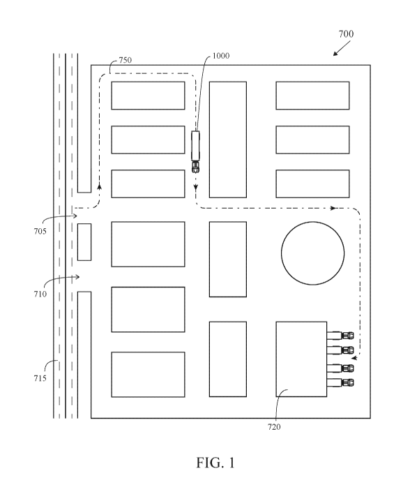
FIG. 1 is an illustration of a micro-navigation guidance map for a facility
700.
The facility has an entrance 705 from and exit 710 to a street 715. Macro-
navigation
CA 03154483 2022-03-11
WO 2021/055384
PCT/US2020/050940
13
would guide a vehicle 1000 to the street entrance 705 of the facility 1000.
Within the
facility 700, a vehicle must unload at a loading bay area 720. The vehicle is
guided
utilizing micro-navigation guidance to follow a path 750 from the entrance 705
to the
loading bay area 720 and then to return to the street 715 from the loading bay
area
720 by following the path 750.
FIG. 2 is a block diagram of a vector matching process 2000 for a micro-
navigation system. At block 2010, vehicle configuration information is
communicated with a secure network 2005. At block 2015, Known Route
information is communicated, preferably using a server, with the secure
network
2005. This information is preferably retrieved from a database by the server.
At block
2020, Known Tasks, preferably from a database, are communicated with the
secure
network 2005. The data from the vehicle configuration block 2010, the Known
Route
block 2015 and the Known Tasks block 2020, are provided, preferably using a
server,
to a Known Routing block 2025 and then to an uncharted routing block 2030.
As shown in FIG. 2A, at step A, the micro-navigation system (preferably a
server
with databases in communication with a CVD within the vehicle) tracks all of
the
movement from a transition point, TX, to a mark position trigger. At step B, a
vector
captures duration for speed and a line is drawn for distance. As shown in FIG.
2B, at
step C a vehicle is assigned a target to create an endpoint. At step D, the
micro-
navigation system calculates a best-fit linear path for the vehicle. Then the
micro-
navigation system compares the best-fit linear path to known paths for a
similar
configuration. Then the micro-navigation system iterates the smoothest path or
shortest path for the vehicle.
FIG. 2C illustrates providing different micro-navigation routes to a similar
end
point for vehicles that differ in configuration or size. A vehicle A is
provided a first
route to end point R. A vehicle B, of a different size from vehicle A, is
provided a
different route to an end point R. A vehicle C, of a different configuration
than
vehicles A and B, is a provided a different route to an end point R.
The system also preferably includes physical infrastructures with
communication
devices comprising at least one of a building, a gate, an access controlled
point of
CA 03154483 2022-03-11
WO 2021/055384
PCT/US2020/050940
14
entry, a parking structure, a weigh station, a toll collection structure, a
fueling
equipment and a vehicle service equipment. In one embodiment, a passive device
on a
physical structure broadcasts a unique ID which is received by a mobile device
and a
vehicle gateway device. If the passive device is a BLUETOOTH device, it
broadcasts
a BLUETOOTH advertisement.
Multiple vehicle connected mobility devices are preferably used with the
system 1600 and comprise at least one of a tablet computer, a mobile phone, a
scanning device, a beacon, a RF passive or active communication device and a
signature capture device. The vehicle 1000 is preferably one of a long-haul
semi-
truck, a bus, a sedan, a pick-up, a sports utility vehicle, a limousine, a
sports car, a
delivery truck, a van, or a mini-van.
As shown in FIG. 3, the vehicle 1000 has multiple connection points with
direct connectivity to a CVD 135, and requires no routing through a cloud
service.
The endpoints are user interfaces or built in displays, devices connected
through fixed
or wireless connection to the vehicle's CVD 135, sensors connected through a
vehicle
bus (see FIG. 4A) to the CVD 135, or directly to the CVD 135 via wired or
wireless
connection, like devices. The vehicle 1000 is preferably a primary generator
and
source of VTEP data 1160.
The RPM 1130 preferably comprises a RPM sync 1135 for syncing with other
devices, servers, the Cloud, the CVD and the like.
The real-time data for the vehicle 1000 preferably comprises a real-time speed
of the
vehicle, tire pressure values from a plurality of tire sensors,
refrigeration/HVAC unit
values, a plurality of fluid levels, a plurality of power unit values, a real-
time fuel tank
capacity, and a fuel type. The plurality of configurable real-time vehicle
data trigger
events comprises a value outside of a predetermined range for the real-time
data of
the vehicle.
The real-time driver/operator profile comprises amount of time driving during
a pre-determined time period, number of rest breaks during the pre-determined
time
period, license compliance data, physical disabilities and driving violations.
One
example of an off-vehicle source is a fuel stop. A profile of a fuel stop
preferably
CA 03154483 2022-03-11
WO 2021/055384
PCT/US2020/050940
comprises real-time types of fuels available, set billing instructions,
physical
dimensions of a plurality of fuel pumps, GPS coordinates, hours of operation,
food
service availability, and resting area availability. The predetermined fueling
time
period is a time range to fuel the vehicle based on the real-time GPS location
of the
5 vehicle, the real-time speed of the vehicle, the distance to the selected
fuel stop from
the real-time GPS location of the vehicle, and the hours of operation of the
fuel stop.
A configuration of the vehicle 1000 is preferably selected from one of a
single trailer,
a dual trailer, a triple trailer, and a refrigeration trailer.
Another example of an off-vehicle source is a database (Federal, State local)
10 with dynamic compliance rules. The dynamic compliance rules comprise
speed limits,
transport of toxic waste, the transport of refrigerated cargo, the rest
durations for
drivers/operators, the necessary insurance coverage, and the type of taxes and
fees to
be paid.
The workflow utilized by the assigning authority engine 1105 preferably
15 comprises an origination location of the vehicle, a destination of the
vehicle, a micro-
navigation route to the destination, a cargo, a time of departure and a time
of arrival.
FIG. 4 is an illustration of multiple sensors on a truck 1000. The
vehicle/truck
1000 preferably comprises an oil level sensor 1005, an engine sensor 1010, a
power
sensor 1015, a refrigeration/HVAC sensor 1020, a temperature sensor 1025, a
tire
pressure sensor 1030, and a fuel sensor 1035. Those skilled in the pertinent
art will
recognize that multiple other sensors may be utilized without departing from
the
scope and spirit of the present invention. FIG. 4A is an illustration of
multiple sensors
on a truck connected to a data bus for the truck. Each of the sensors (oil
level sensor
1005, engine sensor 1010, a power sensor 1015, a refrigeration/HVAC sensor
1020, a
temperature sensor 1025, tire pressure sensors 1030a-d, and fuel sensor 1035)
is
preferably connected to the data bus for transferring data to an on-board
computer of
the vehicle 1000, or directly to the CVD 135. Alternatively, some or all of
the sensors
use wireless communications to communication with the CVD 135.
FIG. 5 is a flow chart for a method 500 for remote profile management for
utilizing data and computational information from on-vehicle and off-vehicle
sources
CA 03154483 2022-03-11
WO 2021/055384
PCT/US2020/050940
16
for micro-navigation. At block 501, the contents of each of a plurality of
databases are
accessed by an assigning authority engine. At block 502, the contents are
combined to
produce a plurality of dynamic, temporal combinations of data elements and a
plurality of instruction sets for a vehicle. At block 503, the plurality of
dynamic,
temporal combinations is executed. At block 504, data from a plurality of
cloud
sources comprising third party data and vehicle, timing, event, and/or
positioning
("VTEP") data is accessed to inform the plurality of instruction sets
delivered by the
assigning authority engine to the RPM. At block 505, one or more elements of
the
VTEP data is used as a basis to synchronize timing between the data, or
computational outputs of two or more sources of electronic information. At
block
506, a single coherent information picture is formed from fusing data and
computational information from the on-vehicle and the off-vehicle sources.
A system 10 for securely connecting a wireless device to a single access point
in a vehicle for a predetermined work assignment (that preferably includes a
micro-
navigation route) is shown in FIGS. 6 and 6A. The system 10 preferably
comprises a
remote server (cloud) 11, a vehicle gateway device 130, a smart device 110 and
a
passive device 61. The vehicle gateway device 130 is preferably a connected
vehicle
device ("CVD").
The server/cloud 11 accesses dataset 12 and obtains driver information.
Vehicle information, mobile device information (MAC address), passive device
information (beacon ID) and other information to compile a SCP packet 14. At
block
15, the server 11 provides SCP definitions to the vehicle gateway device 130
and the
mobile device 110. At block 16 the server/cloud 11 authorizes the SCP. At
block 17,
the server/cloud 11 communicates with the vehicle gateway device 130.
The vehicle gateway device 130 uses datasets 22, with the beacon ID 23, a
scan of wireless devices 24 along with the SCP definitions 26 received from
the
server/cloud 11 to compile a CVD compiled SCP packet 25. The CVD compiled SCP
packet is sent to the cloud/server 11 at block 16 and authorization/validation
of the
CVD compiled SCP packet is received at block 27. At block 28 the SCP is
authorized
for broadcasting at the vehicle gateway device 130 a wireless network with a
hidden
CA 03154483 2022-03-11
WO 2021/055384
PCT/US2020/050940
17
and hashed SSID unique to the vehicle, the hidden and hashed SSID generated
from
the validated SCP packet. At block 29, the vehicle gateway device 130
communicates
the broadcast with the server/cloud 11. At block 31, the vehicle gateway
device 130
communicates with other devices, namely the smart device 110 over preferably a
WiFi hotspot 32 and the passive device 61 by pairing using a BLUETOOTH
communication protocol at block 33.
At block 49, the smart device (mobile device) 110 compiles a complied
mobile device SCP packet from the SCP definitions 42, the data sets 48, the
beacon
ID 43, the Tablet ID 45, a driver ID 46, a vehicle ID 47 and scan of wireless
devices
44. The mobile device 110 generates the hashed SSID and a passphrase from the
complied mobile device SCP packet. At block 51, the mobile device 110 connects
to
the WiFi hotspot 32 of the vehicle device gateway 130.
The passive device 61 broadcast a unique ID at block 62 which is received by
the mobile device 110 and the vehicle gateway device 130. At block 63, if a
BLUETOOTH device, it broadcasts a BLUETOOTH advertisement at block 64.
The SCP is defined by an assigning authority in the server/cloud 11. The
server/cloud
11 sends the SCP definition and any other required data in datasets to the CVD
130
and the mobile device 110. The CVD 130 adds the contextual data from local
datasets
to the sever-sent data to compile its SCP based definition. The local datasets
include
data wirelessly scanned from passive devices, preferably transmitting a
BLUETOOTH beacon. Other local datasets include information from the vehicle.
The CVD 130 sends its compiled SCP packet to the server 11 for authorization.
The
server 11 verifies the CVD compiled SCP packet, and if valid, the server 11
transmits
a validation/approval signal to the CVD 130. The CVD then generates an access
point
SSID/passphrase with SCP. Likewise, the mobile device 110 utilizes contextual
data
from local datasets to compile its SCP based on the definitions. The mobile
device
110 connects to the access point of the CVD 130 using the SCP. The CVD 130 and
the mobile device 110 also connect to the passive device 61 since it is part
of the SCP
definition.
CA 03154483 2022-03-11
WO 2021/055384
PCT/US2020/050940
18
As used by the assigning authority engine 1105, a predetermined work
assignment is a temporal event with a fixed start and completion based on
assignable
boundary conditions. The assignable boundary condition is at least one of a
predetermined time period, a geographical destination, or a set micro-
navigation
route. Alternatively, the assignable boundary condition is any feature with a
beginning and a termination. The assigning authority is performed by a person
or
persons, who have the appropriate authority and mechanisms to assign specific
tasks
and assets to a specific vehicle and vehicle operator or custodian, and to
assign
workflow assignments to same. The predetermined work assignment is assigned to
a
known person or entity that has its own primary networked device accessible
through
a password protected user interface, a specific name and password that auto-
populates or otherwise automatically satisfies a plurality of credentials
requirements,
wherein the plurality of credential requirements are automatically available
or
revoked based on the assignable boundary condition identified in a pairing
event.
The CVD 130 preferably broadcasts a WiFi wireless network with a hidden and
hashed SSID unique to the host vehicle and protected by a unique, dynamically
generated and hashed passphrase. The vehicle ID is entered into an application
on the
tablet that is then converted to the same hashed SSID and passphrase, which
allows
the tablet to attempt to connect to the corresponding CVD WiFi network and
begin
communication.
A method 900 for a secure connection to a wireless network of a vehicle is
shown in FIG. 7. At block 901, a server generates definitions for a SCP packet
for
assigning authority for a vehicle. At block 902 the server transmits the
definitions for
the SCP packet to a CVD and a mobile device. At block 903, the CVD compiles
the
SCP packet to generate a CVD compiled SCP. At block 904, the CVD transmits the
CVD compiled SCP to the server for authorization. At block 905, the server
transmits
authorization for the CVD compiled SCP from to the CVD for creation of a
validated
SCP. At block 906, the mobile device generates a dataset to compile a mobile
device
compiled SCP. At block 907, the CVD broadcasts at a wireless network with a
hidden
and hashed SSID unique to the vehicle. The hidden and hashed SSID is generated
CA 03154483 2022-03-11
WO 2021/055384
PCT/US2020/050940
19
from the validated SCP packet. At block 908, the mobile device generates the
hashed
SSID and a passphrase from the dataset, which allows the mobile device connect
to
the wireless network. At block 909, the mobile device searches for a vehicle
having
the CVD broadcasting the wireless network in a hidden mode. At block 910, the
mobile device securely connects with the CVD.
One embodiment utilizes a system for vehicle to mobile device secure wireless
communications. The system comprises a vehicle 210, a CVD 130, a mobile device
110 and a passive communication device 61. The vehicle 210 comprises an on-
board
computer with a memory having a vehicle identification number (VIN), a
connector
plug, and a motorized engine. The CVD 130 comprises a processor, a WiFi radio,
a
BLUETOOTH radio, a memory, and a connector for mating with the connector plug
of the vehicle. The mobile device 110 comprises a graphical user interface, a
mobile
application, a processor, a WiFi radio, and a cellular network interface. The
passive
communication device 61 operates on a BLUETOOTH communication protocol. The
server 11 is configured to generate a plurality of definitions for a SCP
packet for
assigning authority for the vehicle. The server 11 is configured to transmit
the
plurality of definitions for the SCP packet from the server to the CVD 130 and
the
mobile device 110. The CVD 130 is configured to compile the SCP packet to
generate
a CVD compiled SCP. The CVD 130 is configured to transmit the CVD compiled
SCP to the server 11 for authorization. The server 11 is configured to
transmit
authorization for the CVD compiled SCP to the CVD 130 for creation of a
validated
SCP. The mobile device 110 is configured to generating a dataset to compile a
mobile
device compiled SCP. The CVD 130 is configured to broadcast a wireless network
with a hidden and hashed SSID unique to the vehicle, the hidden and hashed
SSID
generated from the validated SCP packet. The mobile device 110 is configured
to
generate the hashed SSID and a passphrase from the dataset, which allows the
mobile
device connect to the wireless network. The mobile device 110 is configured to
search
for a vehicle having the CVD broadcasting the wireless network in a hidden
mode.
The mobile device 110 is configured to connect to the CVD 130 over the
wireless
network.
CA 03154483 2022-03-11
WO 2021/055384
PCT/US2020/050940
The dataset preferably comprises at least one of a plurality of definitions
for
the SCP packet, a tablet ID, a driver ID, a vehicle ID, a beacon ID,
identified or
defined entity/participant to the transaction, descriptions, actions, or
states of thing,
characteristics of identifiable devices, when present in a certain proximity
and/or
5 .. context.
Optionally, the mobile device 110 connects to a passive device, the passive
device operating on a BLUETOOTH communication protocol. The passive device 61
is preferably a BLUETOOTH enabled device advertising a unique ID as a beacon
or a
complex system (speaker, computer, etc.) that emits BLUETOOTH enabled device
10 advertising a unique ID as a beacon.
The mobile device 110 preferably receives input from a driver of the vehicle,
and/or the server 11 contains the assigning authority that generates the SCP
definitions.
The passive device 61 is preferably an internal device in the vehicle or an
15 external device posted on a gate to a facility and generating a beacon.
The beacon
from the passive device is preferably a mechanism to ensure that the
connection
between the mobile device 110 and the CVD 130 occurs at a specific physical
location dictated by the assigning authority through the server 11.
Preferably, the
automatic connection between the mobile device 110 and the CVD occurs because
the
20 assigning authority, through the server, has dictated that it occur.
As shown in FIG. 8, a staging yard for trucks 210a-201d, each of a multitude
of trucks 210a-210d broadcast a wireless signal for a truck specific network,
with one
truck 210c broadcasting a wireless signal 225. However, the SSID is not
published so
unless a driver is already in possession of the SSID, the driver will not be
able to pair
the tablet computer 110 with the CVD 130 of the truck 210 to which the driver
is
assigned. So even though the wireless signals are being "broadcast", they will
not
appear on a driver's tablet computer 110 (or other mobile device) unless the
tablet
computer 110 has already been paired with the CVD 130 of the vehicle 210. A
driver
205 in possession of a tablet computer 110 pairs, using a signal 230, the
tablet
computer 110 with the wireless network 225 of the CVD of the truck 210c, and
thus
CA 03154483 2022-03-11
WO 2021/055384
PCT/US2020/050940
21
the driver locates the specific truck 210c he is assigned to in a parking lot
full of
identical looking trucks 210a-d.
The mobile communication device 110, or mobile device, is preferably
selected from mobile phones, smartphones, tablet computers, PDAs and the like.
Examples of smartphones and the device vendors include the 'PHONE smartphone
from Apple, Inc., the DROID smartphone from Motorola Mobility Inc., GALAXY
S smartphones from Samsung Electronics Co., Ltd., and many more. Examples of
tablet computing devices include the IPAD tablet computer from Apple Inc.,
and
the XOOMTm tablet computer from Motorola Mobility Inc.
The mobile communication device 110 then a communication network utilized
preferably originates from a mobile communication service provider (aka phone
carrier) of the customer such as VERIZON, AT&T, SPRINT, T-MOBILE, and the
like mobile communication service providers, provide the communication network
for
communication to the mobile communication device of the end user.
Wireless standards utilized include but are not limited to 802.11a, 802.11b,
802.11g, 802.11n, 802.11ac, 802.11ax, AX.25, 3G, 4G, 5G, CBRS (Citizens
Broadband Radio Service), CDPD, CDMA, GSM, GPRS, radio, microwave, laser,
Bluetooth, 802.15, 802.16, NFC (near field communications), RFID, ZIGBEE,
Zwave, LoRa and IrDA.
BLUETOOTHTm technology operates in the unlicensed 2.4 GHz band of the
radio-frequency spectrum, and in a preferred embodiment the secondary device
30
and/or primary device 25 is capable of receiving and transmitting signals
using
BLUETOOTHTm technology or BLUETOOTH LE technology. LTE Frequency
Bands include 698-798MHz (Band 12, 13, 14, 17); 791-960MHz (Band 5, 6, 8,
.. 18,19,20); 1710-2170MHz (Band 1, 2, 3, 4, 9, 10, 23, 25, 33, 34, 35, 36,
37, 39);
1427-1660.5MH (Band 11, 21, 24); 2300-2700MHz (Band 7, 38, 40, 41); 3400-
3800MHz (Band 22, 42, 43), and in a preferred embodiment the secondary device
30
and/or the primary device 25 is capable of receiving and transmitting signals
using
one or more of the LTE frequency bands. WiFi preferably operates using
802.11a,
802.11b, 802.11g, 802.11n communication formats as set for the by the IEEE,
and in
CA 03154483 2022-03-11
WO 2021/055384
PCT/US2020/050940
22
in a preferred embodiment the secondary device 30 and/or the primary device 25
is
capable of receiving and transmitting signals using one or more of the 802.11
communication formats. Near-field communications (NFC) may also be utilized.
As shown in FIG. 9, a typical mobile communication device 110 preferably
includes an accelerometer 301, I/0 (input/output) 302, a microphone 303, a
speaker
304, a GPS chipset 305, a Bluetooth component 306, a Wi-Fi component 307, a
3G/4G component 308, RAM memory 309, a main processor 310, an OS (operating
system) 311, applications/software 312, a Flash memory 313, SIM card 314, LCD
display 315, a camera 316, a power management circuit 317, a battery 318 or
power
source, a magnetometer 319, and a gyroscope 320.
Each of the interface descriptions preferably discloses use of at least one
communication protocol to establish handshaking or bi-directional
communications.
These protocols preferably include but are not limited to XML, HTTP, TCP/IP,
Serial, UDP, FTP, Web Services, WAP, SMTP, SMPP, DTS, Stored Procedures,
Import/Export, Global Positioning Triangulation, IM, SMS, MMS, GPRS and Flash.
Databases that may be used with the system preferably include but are not
limited to
MS SQL, Access, My SQL, Progress, Oracle, DB2, Open Source DBs and others.
Operating system used with the system preferably include Microsoft 2010, XP,
Vista,
200o Server, 2003 Server, 2008 Server, Windows Mobile, Linux, Android, Unix, I
series, AS 400 and Apple OS.
The underlying protocol at the cloud server is preferably Internet Protocol
Suite (Transfer Control Protocol/Internet Protocol ("TCP/IP")), and the
transmission
protocol to receive a file is preferably a file transfer protocol ("FTP"),
Hypertext
Transfer Protocol ("HTTP"), Secure Hypertext Transfer Protocol ("HTTPS") or
other
similar protocols. The transmission protocol ranges from SIP to MGCP to FTP
and
beyond. The protocol at the authentication server 40 is most preferably HTTPS.
Wireless standards preferably include 802.11a, 802.11b, 802.11g, AX.25, 3G,
CDPD,
CDMA, GSM, GPRS, radio, microwave, laser, Bluetooth, 802.15, 802.16, and IrDA.
Components of a cloud computing server 40 of the micro-navigation system,
as shown in FIG. 10, preferably includes a CPU component 401, a graphics
CA 03154483 2022-03-11
WO 2021/055384
PCT/US2020/050940
23
component 402, PCl/PCI Express 403, memory 404, non-removable storage 407,
removable storage 408, Network Interface 409, including one or more
connections to
a fixed network, and SQL database(s) 45a-45d, which includes the venue's CRM.
Included in the memory 404, is an operating system 405, a SQL server 406 or
other
database engine, and computer programs/software 410. The server 40 also
preferably
includes at least one computer program configured to receive data uploads and
store
the data uploads in the SQL database. Alternatively, the SQL server can be
installed
in a separate server from the server 40.
A flow chart for an alternative method 600 for a secure connection to a
wireless network of a vehicle is shown in FIG. 11. At block 601, the CVD
broadcasts
an encrypted, blind SSID based on specific vehicle data. At block 602,
leveraging the
known vehicle data and the encryption algorithm a mobile device searches for a
vehicle having a CVD broadcasting the wireless network. At block 603, the
mobile
device is connected with the CVD.
A system for a secure connection to a wireless network of a vehicle is shown
in FIG. 12. A truck 210a. Those skilled in the pertinent art will recognize
that the
truck 210a may be replaced by any type of vehicle (such as a bus, sedan, pick-
up,
sport utility vehicle, limousine, sports car, delivery truck, van, mini-van,
motorcycle,
and the like) without departing from the scope of spirit of the present
invention. The
truck 210a preferably comprises a motorized engine 234, a vehicle
identification
number ("VIN"), an on-board computer 232 with a memory 231 and a connector
plug
235. The on-board computer 232 preferably has a digital copy of the VIN in the
memory 231. The on-board computer 232 is preferably in communication with the
motorized engine 234. The truck 210a may also have a GPS component for
location
.. and navigation purposes, a satellite radio such as SIRIUS satellite radio,
a driver
graphical interface display, a battery, a source of fuel and other components
found in
a conventional long distance truck. Also in the truck 210a is a CVD 130
comprising a
processor, a WiFi radio, a BLUETOOTH radio, a memory and a connector to
connect
to the connector plug of the on-board computer 232. A driver 205 preferably
has a
mobile communication device such as a tablet computer 110 in order to pair
with a
CA 03154483 2022-03-11
WO 2021/055384
PCT/US2020/050940
24
wireless network generated by the CVD 130 of the truck 210a. The tablet
computer
110 preferably comprises a graphical user interface 335, a processor 310, a
WiFi radio
307, a BLUETOOTH radio 306, and a cellular network interface 308.
As shown in FIG. 13, a staging yard for trucks 210a-210k, each of a multitude
of trucks 210a-210k broadcast a wireless signal 224a-k for a truck specific
network,
with one truck 210f broadcasting a wireless signal 225. However, all of the
wireless
signal 224a-224k and 225 do not publish their respective SSID so that a mobile
device 110 must already be paired with the CVD 130 of the truck 210 in order
to
connect to the truck based wireless network 224a-224k or 225 of each of the
CVDs
130 of each of the trucks 210a-210k. A driver 205 in possession of a tablet
computer
110 pairs with the specific truck wireless network 225 of the CVD 130 of the
truck
210f, and thus the driver locates the specific truck 210f the driver is
assigned to in a
parking lot full of identical looking trucks 210a-210k.
One embodiment is a system for micro-navigation. The system preferably
comprises a truck 210, a CVD 130, a tablet computer (mobile device) 110, a
server 40
and a plurality of databases. The vehicle preferably comprises an on-board
computer
with a memory having a vehicle identification number (VIN), a connector plug,
and a
motorized engine. The CVD 130 comprises a processor, a WiFi radio, a
BLUETOOTH radio, a memory, and a connector for mating with the connector plug
of the vehicle. The tablet computer 110 comprises a graphical user interface,
a
processor, a WiFi radio, a BLUETOOTH radio, and a cellular network interface.
A
location of the truck 210 is preferably determined using a GPS component of
the
truck 210. The location of the truck 210 is transmitted to the server 140 by
the CVD.
The server 40 retrieves a micro-navigation guidance protocol for the location
of the
truck from the plurality of databases. The server 40 transmits the micro-
navigation
guidance protocol to the CVD 130 for display on the tablet computer 110. The
micro-
navigation guidance protocol is activated on the tablet computer 110 for
example
upon arrival at the entrance of a destination site. The truck 210 is guided
using the
micro-navigation guidance protocol from the entrance to a terminal location
within
the destination site. The server can also provide real-time compliance rules
that
CA 03154483 2022-03-11
WO 2021/055384
PCT/US2020/050940
pertain to speed limits, transport of toxic waste, the transport of
refrigerated cargo, the
rest durations for drivers, the necessary insurance coverage, the type of
taxes and fees
to be paid, and the like. The display on the tablet computer is preferably in
the form of
a visual alert, an audio alert or a haptic alert. Other displays include forms
such as
5 attestation forms, and data such as timers, current speed limits, and the
like. A trigger
is preferably from the GPS of the truck 210, the speed of the truck 210,
cellular or
WiFi triangulation from a network, and the like.
The CVD 130 obtains the vehicle identification number (VIN) from the on-board
computer and transmits the VIN with the location to the server 140 for
verification of
10 the truck 210.
Another embodiment is a micro-navigation system that utilizes a remote
profile manager for utilizing multiple vehicle odometer values. The system
comprises
a vehicle 210, a CVD 130, a tablet computer 110, a server 40 and a plurality
of
databases. The vehicle comprises an on-board computer with a memory having a
15 vehicle identification number (VIN), a connector plug, a motorized
engine, an
odometer component from an engine source, an odometer component from a
dashboard source, an odometer component from a chassis source, and an odometer
component from a transmission source. Thus, the truck 210 has a multiple of
odometers that can be used to determine a mileage of the truck 210. The
connected
20 vehicle device (CVD) 130 comprises a processor, a WiFi radio, a
BLUETOOTH
radio, a memory, and a connector for mating with the connector plug of the
vehicle.
The tablet computer 110 comprises a graphical user interface, a processor, a
WiFi
radio, a BLUETOOTH radio, and a cellular network interface. Each of the
odometer
component from an engine source, the odometer component from a dashboard
source,
25 the odometer component from a chassis source, and the odometer component
from a
transmission source generates an odometer value. The CVD 130 generates a delta
value for odometer value relative to a control odometer value. The CVD 130
monitors
the odometer value from each of the odometer component from an engine source,
the
odometer component from a dashboard source, the odometer component from a
chassis source, and the odometer component from a transmission source. The CVD
CA 03154483 2022-03-11
WO 2021/055384
PCT/US2020/050940
26
130 generates a new odometer value for one of the odometer component from an
engine source, the odometer component from a dashboard source, the odometer
component from a chassis source, and the odometer component from a
transmission
source, and the CVD modifies the odometer value by the delta value to generate
the
new odometer value. The new odometer value can be used with the micro-
navigation.
As shown in FIG. 14, a method for micro-navigation of a vehicle is generally
designated 1400. At block 1401, a vehicle is guided utilizing macro-navigation
to
travel from an origination site of an entrance of a destination site. Guidance
is
preferably provided from a server over a communications network to a CVD
within
the vehicle, and then to a mobile device of the operator of the vehicle. At
block 1402,
a micro-navigation guidance protocol is activated upon arrival at the entrance
of the
destination site. At block 1403, the vehicle is guided using the micro-
navigation
guidance protocol (preferably on the mobile device with follow-up instructions
from
the server if needed) from the entrance to a terminal location within the
destination
site.
As shown in FIG. 15, a method for a micro-navigation of a vehicle is
generally designated 1500. At block 1501, a server collects data related to
route
transit to specific end points that are not typically mapped. At block 1502,
those end
points are identified, by the server, by relating specific geo coordinates, or
physical
landmark based characteristics, or electronically described and defined end
point to a
an identification that will be entered and stored in a location database. At
block 1503,
guidance is provided by the server to vehicles traveling to those end points
or
destinations, with additional information relevant to a route and/or a
specific vehicle
and configuration updated and made available to the system.
As shown in FIG. 16, a method for a micro-navigation of a vehicle is
generally designated 1600. At block 1601, a real-time GPS location for a
vehicle is
determined by the vehicle or a mobile device located on the vehicle. At block
1602,
an arrival at a destination site based on the real-time GPS location for the
vehicle is
determined by a server. At block 1603, a micro-navigation guidance protocol
upon
arrival at the entrance of the destination site is transmitted from the server
to a CVD
CA 03154483 2022-03-11
WO 2021/055384
PCT/US2020/050940
27
of the vehicle, and then preferably to a mobile device of the operator of the
vehicle.
At block 1604, the vehicle is guided using the micro-navigation guidance
protocol
(preferably on the mobile device) from the entrance to a terminal location
within the
destination site.
As shown in FIG. 17, a method for a micro-navigation at a facility is
generally
designated 1700. At block 1701, a wireless network having a SSID is broadcast
from
a CVD connected to an on-board computer of a vehicle, wherein the SSID of the
wireless network is not published. At 1702, a mobile device searches for a
vehicle
having a CVD broadcasting the wireless network with the unpublished SSID. At
block 1703, the mobile device connects with the CVD. At block 1704, a vehicle
is
guided utilizing macro-navigation (preferably on the mobile device) to travel
from an
origination site of an entrance of a destination site. At block 1705, a micro-
navigation
guidance protocol on the mobile device is activated upon arrival at the
entrance of the
destination site. At block 1706, the vehicle is guided using the micro-
navigation
guidance protocol on the mobile device from the entrance to a terminal
location
within the destination site.
An operating system preferably controls the execution of other computer
programs, running of the PSO platform, and provides scheduling, input-output
control, file and data management, memory management, and communication
control
and related services. The operating system may be, for example Windows
(available
from Microsoft, Corp. of Redmond, Wash.), LINUX or other UNIX variants
(available from Red Hat of Raleigh, N.C. and various other vendors), Android
and
variants thereof (available from Google, Inc. of Mountain View, Calif), Apple
OS X,
iOs and variants thereof (available from Apple, Inc. of Cupertino, Calif.), or
the like.
The system and method described in connection with the embodiments
disclosed herein is preferably embodied directly in hardware, in a software
module
executed by a processor, or in a combination of the two. A software module
preferably resides in flash memory, ROM memory, EPROM memory, EEPROM
memory, RAM memory, registers, a hard disk, a removable disk, a CD-ROM, or any
other form of storage medium known in the art. An exemplary storage medium is
CA 03154483 2022-03-11
WO 2021/055384
PCT/US2020/050940
28
preferably coupled to the processor, so that the processor reads information
from, and
writes information to, the storage medium. In the alternative, the storage
medium is
integral to the processor. In additional embodiments, the processor and the
storage
medium reside in an Application Specific Integrated Circuit (ASIC). In
additional
embodiments, the processor and the storage medium reside as discrete
components in
a computing device. In additional embodiments, the events and/or actions of a
method
reside as one or any combination or set of codes and/or instructions on a
machine-
readable medium and/or computer-readable medium, which are incorporated into a
computer software program.
In additional embodiments, the functions described are implemented in
hardware, software, firmware, or any combination thereof If implemented in
software, the functions are stored or transmitted as one or more instructions
or code
on a computer-readable medium. Computer-readable media includes both computer
storage media and communication media including any medium that facilitates
transfer of a computer program from one place to another. A storage medium is
any
available media that is accessed by a computer. By way of example, and not
limitation, such computer-readable media can comprise RAM, ROM, EEPROM, CD-
ROM or other optical disk storage, magnetic disk storage or other magnetic
storage
devices, or any other medium that can be used to carry or store desired
program code
in the form of instructions or data structures, and that can be accessed by a
computer.
Also, any connection is termed a computer-readable medium. For example, if
software is transmitted from a website, server, or other remote source using a
coaxial
cable, fiber optic cable, twisted pair, digital subscriber line (DSL), or
wireless
technologies such as infrared, radio, and microwave, then the coaxial cable,
fiber
optic cable, twisted pair, DSL, or wireless technologies such as infrared,
radio, and
microwave are included in the definition of medium. "Disk" and "disc", as used
herein, include compact disc (CD), laser disc, optical disc, digital versatile
disc
(DVD), floppy disk and BLU-RAY disc where disks usually reproduce data
magnetically, while discs usually reproduce data optically with lasers.
Combinations
of the above should also be included within the scope of computer-readable
medium.
CA 03154483 2022-03-11
WO 2021/055384
PCT/US2020/050940
29
A computer program code for carrying out operations of the Present Invention
is preferably written in an object oriented, scripted or unscripted
programming
language such as C++, C#, SQL, Java, Python, Javascript, Typescript, PHP,
Ruby, or
the like.
Each of the interface descriptions preferably discloses use of at least one
communication protocol to establish handshaking or bi-directional
communications.
These protocols preferably include but are not limited to XML, HTTP, TCP/IP,
Serial, UDP, FTP, Web Services, WAP, SMTP, SNIPP, DTS, Stored Procedures,
Import/Export, Global Positioning Triangulation, IM, SMS, MMS, GPRS and Flash.
The databases used with the system preferably include but are not limited to
MS SQL,
Access, My SQL, Oracle, DB2, Open Source DBs and others. Operating system used
with the system preferably include Microsoft 2010, XP, Vista, 200o Server,
2003
Server, 2008 Server, Windows Mobile, Linux, Android, Unix, I series, AS 400
and
Apple OS.
The underlying protocol at a server, is preferably Internet Protocol Suite
(Transfer Control Protocol/Internet Protocol ("TCP/IP")), and the transmission
protocol to receive a file is preferably a file transfer protocol ("FTP"),
Hypertext
Transfer Protocol ("HTTP"), Secure Hypertext Transfer Protocol ("HTTPS"), or
other
similar protocols. The protocol at the server is preferably HTTPS.
Components of a server includes a CPU component, a graphics component,
memory, non-removable storage, removable storage, Network Interface, including
one or more connections to a fixed network, and SQL database(s). Included in
the
memory, is an operating system, a SQL server or other database engine, and
computer programs/software.