Note: Descriptions are shown in the official language in which they were submitted.
FLIGHT MANAGEMENT METHOD AND SYSTEM USING SAME
FIELD OF THE DISCLOSURE
100011 The present disclosure relates to risk assessment for aviation,
and, in particular,
to a flight management method and system using same.
BACKGROUND
100021 Various digital platforms exist for assessing a flight plan upon
request in view
of weather data. However, it remains a challenge to assess flight risks when
an aircraft is
in flight, and more so to assess flight risks in an automated fashion.
100031 This background information is provided to reveal information
believed by the
applicant to be of possible relevance. No admission is necessarily intended,
nor should be
construed, that any of the preceding information constitutes prior art or
forms part of the
general common knowledge in the relevant art.
SUMMARY
100041 The following presents a simplified summary of the general
inventive
concept(s) described herein to provide a basic understanding of some aspects
of the
disclosure. This summary is not an extensive overview of the disclosure. It is
not intended
to restrict key or critical elements of embodiments of the disclosure or to
delineate their
scope beyond that which is explicitly or implicitly described by the following
description
and claims.
100051 A need exists for a flight management method and system using same
that
overcomes some of the drawbacks of known techniques, or at least, provides a
useful
alternative thereto. Some aspects of this disclosure provide examples of such
systems and
methods.
100061 In accordance with one aspect, there is provided a digital flight
management
system comprising: a digital processing environment comprising computer-
executable
1
1352P-MMD-CADI
Date Recue/Date Received 2022-04-19
instructions to access flight request data related to a flight plan, aircraft
parameter data
related to an aircraft associated with the flight plan, a flight risk data
source, and
geographical data corresponding to a geographical area associated with the
flight plan;
wherein the digital processing environment further comprises computer-
executable
instructions to calculate a predicted flight path based at least in part on
the flight request
data and the geographical data; digitally compare, based at least in part on
the aircraft
parameter data, the predicted flight path with flight risk data from the
flight risk data source
to assess a flight risk associated with the predicted flight path; and display
via a user
interface the predicted fight path in accordance with the flight risk.
100071 In one embodiment, the predicted flight path comprises multiple
consecutive
predicted flight path segments automatically calculated by the digital
processing
environment based at least in part on the flight request data and the
geographical data, and
wherein the digital processing environment is operable to digitally compare
each of the
predicted flight path segments with flight risk data from the flight risk data
source to assess
a respective flight risk associated with each of the predicted flight path
segments, and
display via the user interface the predicted fight path segments in accordance
with the
respective flight risk.
100081 In one embodiment, the predicted flight path comprises at least
an outbound
and a return flight path, each one of which comprising respective the multiple
flight path
segments.
100091 In one embodiment, the digital processing environment is operable
to execute
the computer-executable instructions prior to takeoff of the aircraft.
100101 In one embodiment, the digital processing environment is operable
in-flight to
digitally compare the predicted flight path with the flight risk data from the
flight risk data
source in real-time to update the flight risk associated with the predicted
flight path in-
flight; and display via the user interface the predicted fight path in
accordance with the
updated flight risk.
100111 In one embodiment, the flight risk data source comprises a
weather data source.
2
1352P-MMD-CADI
Date Recue/Date Received 2022-04-19
100121 In one embodiment, the flight risk data source comprises a flight
alert
application programming interface (API).
100131 In one embodiment, the digital instructions further comprise
instructions to
provide an alert associated with the flight path via the user interface.
100141 In one embodiment, the flight risk is displayed via the user
interface as an
indicium associated with the predicted flight path.
100151 In one embodiment, the aircraft comprises a plurality of
respective aircrafts, and
wherein the digital processing environment is operable to execute the network-
executable
instructions and the digital instructions for each of the plurality of
respective aircrafts.
100161 In one embodiment, the user interface is user-configurable to
display designated
graphical layers associated with one or more of the predicted flight path, the
flight risk
data, the geographical data, or the aircraft parameter data.
100171 In one embodiment, the computer-executable instructions further
comprise
instructions to access aircraft location data, and calculate a flight
deviation value based on
the aircraft location data and the predicted flight path, and calculate an
updated flight path
based at least in part on the aircraft position data, the geographical data,
and the flight plan.
100181 In one embodiment, the instructions further comprise instructions
to digitally
compare, based at least in part on the aircraft parameter data, the updated
flight path with
flight risk data from the flight risk data source to assess a real-time flight
risk associated
with the updated flight path, and display via the user interface the updated
fight path in
accordance with the real-time flight risk.
100191 In one embodiment, the digital instructions further comprise
instructions to
provide an alert related to an overdue aircraft based at least in part on the
flight plan.
100201 In one embodiment, the predicted flight path comprises an
airspace volume, and
wherein the flight path is compared with the flight risk data associated with
locations
defined within the airspace volume.
3
1352P-MMD-CADI
Date Recue/Date Received 2022-04-19
100211 In one embodiment, the airspace volume comprises a take-off
column
associated with an area around a take-off location, a landing column
associated with an
area around a planned landing location, and a flight path corridor defined
around a planned
flight altitude along the flight plan.
100221 In one embodiment, the take-off column and the landing column are
substantially vertically oriented airspace columns, whereas the flight path
corridor is a
substantially horizontally oriented airspace corridor.
100231 In one embodiment, each of the flight path segments comprises a
corresponding
airspace volume, and wherein each of the flight path segments is compared with
the flight
risk data associated with locations defined within the corresponding airspace
volume.
100241 In one embodiment, the flight risk data source comprises a Notice
to Airman
(NOTAM) feed reporting multiple NOTAM risks; wherein said digital processing
environment further comprises computer-executable instructions to: rank said
multiple
NOTAM risks as a function of said predicted flight path and a user-input
ranking bias to
be applied in ranking said multiple NOTAM risks; digitally compare said
predicted flight
path with flight risk data from said flight risk data source, including a
highest ranking
subset of said NOTAM risks given said user-input ranking bias, to assess said
flight risk
associated with said predicted flight path.
100251 In one embodiment, the user-input ranking bias is selectable from
a predefined
set of designated biases, and wherein said user-input ranking bias is set as a
function of
said flight request data including a requested or predicted flight path
altitude.
100261 In accordance with another embodiment, there is provided a
digital flight
management system comprising: a digital processing environment having computer-
executable instructions to access flight request data related to a flight
plan, aircraft
parameter data related to an aircraft associated with the flight plan, a
flight risk data source,
and geographical data corresponding to a geographical area associated with the
flight plan;
wherein the digital processing environment is further operable to calculate a
predicted
flight path comprising multiple consecutive predicted flight path segments
based at least in
4
1352P-MMD-CADI
Date Recue/Date Received 2022-04-19
part on the flight request data, the geographical data, and the aircraft
parameter data,
digitally compare, based at least in part on the aircraft parameter data, each
of the predicted
flight path segments with flight risk data from the flight risk data source to
assess a
respective flight risk associated with each of the predicted flight path
segments, and display
via a user interface the predicted fight path segments in accordance with the
respective
flight risk.
100271 In accordance with another aspect, there is provided a digital
flight management
system for monitoring an in-flight aircraft, the system comprising: a digital
processing
environment having computer-executable instructions to access flight plan data
associated
with the in-flight aircraft, aircraft parameter data related to the in-flight
aircraft, aircraft
location data, a flight risk data source, and geographical data corresponding
to a
geographical area associated with the flight plan data; wherein the digital
processing
environment is further operable to calculate a predicted flight path based at
least in part on
the flight plan data, the aircraft location data, and the geographical data,
digitally compare,
based at least in part on the aircraft parameter data, the predicted flight
path with flight risk
data from the flight risk data source to assess a flight risk associated with
the predicted
flight path, and display via a user interface the predicted fight path in
accordance with the
flight risk; and wherein the flight risk is updated in real-time in flight and
the display of the
predicted flight path is updated according to the updated flight risk
according.
100281 In accordance with another aspect, there is provided a digital
flight management
system for monitoring an in-flight aircraft, the system comprising: a digital
processing
environment having computer-executable instructions to access predicted flight
path data
associated with the in-flight aircraft and a flight plan, aircraft parameter
data related to the
in-flight aircraft and comprising a flight deviation threshold, aircraft
location data, a flight
risk data source, and geographical data corresponding to a geographical area
associated
with the flight plan; wherein the digital processing environment is further
operable to
calculate a flight deviation value based on the aircraft location data and the
predicted flight
path data, and upon the flight path deviation value exceeding a deviation
threshold value,
calculate an updated flight path based at least in part on the aircraft
position data, the
geographical data, and the flight plan, digitally compare, based at least in
part on the aircraft
5
1352P-MMD-CADI
Date Recue/Date Received 2022-04-19
parameter data, the updated flight path with flight risk data from the flight
risk data source
to assess a flight risk associated with the updated flight path, and display
via a user interface
the updated fight path in accordance with the flight risk.
100291 In accordance with one aspect, there is provided a computer-
readable medium
comprising digital instructions for execution by a digital data processor to
implement one
or more of the above-noted embodiments.
100301 In accordance with another aspect, there is provided a computer-
implemented
digital flight management method comprising: digitally accessing: flight
request data
related to a flight plan; aircraft parameter data related to an aircraft
associated with said
flight plan; a flight risk data source; and geographical data corresponding to
a
geographical area associated with said flight plan; calculating a predicted
flight path
based at least in part on said flight request data and said geographical data;
digitally
comparing, based at least in part on said aircraft parameter data, said
predicted flight path
with flight risk data from said flight risk data source to assess a flight
risk associated with
said predicted flight path; and displaying via a user interface said predicted
fight path in
accordance with said flight risk.
100311 In accordance with another aspect, there is provided a computer-
implemented
digital flight management method comprising: accessing: flight request data
related to a
flight plan; aircraft parameter data related to an aircraft associated with
said flight plan; a
flight risk data source; and geographical data corresponding to a geographical
area
associated with said flight plan; calculating a predicted flight path
comprising multiple
consecutive predicted flight path segments based at least in part on said
flight request
data, said geographical data, and said aircraft parameter data; digitally
comparing, based
at least in part on said aircraft parameter data, each of said predicted
flight path segments
with flight risk data from said flight risk data source to assess a respective
flight risk
associated with each of said predicted flight path segments; and displaying
via a user
interface said predicted fight path segments in accordance with said
respective flight risk.
6
1352P-MMD-CADI
Date Recue/Date Received 2022-04-19
100321 In accordance with another aspect, there is provided a computer-
implemented
digital flight management method comprising: accessing: flight plan data
associated with
the in-flight aircraft; aircraft parameter data related to the in-flight
aircraft; aircraft
location data; a flight risk data source; and geographical data corresponding
to a
geographical area associated with said flight plan data; calculating a
predicted flight path
based at least in part on said flight plan data, said aircraft location data,
and said
geographical data; digitally comparing, based at least in part on said
aircraft parameter
data, said predicted flight path with flight risk data from said flight risk
data source to
assess a flight risk associated with said predicted flight path; and
displaying via a user
interface said predicted fight path in accordance with said flight risk;
wherein said flight
risk is updated in real-time in flight and said display of said predicted
flight path is
updated according to said updated flight risk according.
100331 In accordance with another aspect, there is provided a computer-
implemented
digital flight management method comprising: accessing: predicted flight path
data
associated with the in-flight aircraft and a flight plan; aircraft parameter
data related to
the in-flight aircraft and comprising a flight deviation threshold; aircraft
location data; a
flight risk data source; and geographical data corresponding to a geographical
area
associated with said flight plan; calculating a flight deviation value based
on said aircraft
.. location data and said predicted flight path data, and upon said flight
path deviation value
exceeding a deviation threshold value, calculate an updated flight path based
at least in
part on said aircraft position data, said geographical data, and said flight
plan; digitally
comparing, based at least in part on said aircraft parameter data, said
updated flight path
with flight risk data from said flight risk data source to assess a flight
risk associated with
said updated flight path; and displaying via a user interface said updated
fight path in
accordance with said flight risk.
100341 In accordance with another aspect, here is provided a digital
flight management
system comprising: a digital processing environment comprising computer-
executable
instructions to access: flight request data related to a flight plan; aircraft
parameter data
related to an aircraft associated with said flight plan; a flight risk data
source comprising a
Notice to Airman (NOTAM) feed reporting multiple NOTAM risks; and geographical
data
7
1352P-MMD-CADI
Date Recue/Date Received 2022-04-19
corresponding to a geographical area associated with said flight plan; wherein
said digital
processing environment further comprises computer-executable instructions to:
calculate a
predicted flight path based at least in part on said flight request data and
said geographical
data; rank said multiple NOTAM risks as a function of said predicted flight
path and a user-
input ranking bias to be applied in ranking said multiple NOTAM risks;
digitally compare,
based at least in part on said aircraft parameter data, said predicted flight
path with flight
risk data from said flight risk data source, including a highest ranking
subset of said
NOTAM risks given said user-input ranking bias, to assess a flight risk
associated with
said predicted flight path; and display via a user interface said predicted
fight path in
accordance with said flight risk, comprising risk identification associated at
least in part
with said highest ranking subset of said NOTAM risks.
100351 In one embodiment, the user-input ranking bias is selectable from
a predefined
set of designated biases.
100361 In one embodiment, the user-input ranking bias is set as a
function of said flight
request data including a requested or predicted flight path altitude.
100371 Other aspects, features and/or advantages will become more
apparent upon
reading of the following non-restrictive description of specific embodiments
thereof, given
by way of example only with reference to the accompanying drawings.
BRIEF DESCRIPTION OF THE FIGURES
100381 Several embodiments of the present disclosure will be provided, by
way of
examples only, with reference to the appended drawings, wherein:
100391 Figures lA to 1F are diagrams illustrating an exemplary flight
management
process, in accordance with one embodiment;
100401 Figures 2A and 2B are diagrams of exemplary flight request
weather logic
flows, in accordance with one embodiment;
100411 Figure 3 is a diagram of an exemplary overdue alert decision
tree, in accordance
with one embodiment;
8
1352P-MMD-CADI
Date Recue/Date Received 2022-04-19
100421 Figures 4A to 4C are image of an exemplary user interface for
inputting aircraft
parameter data, in accordance with various embodiments;
100431 Figure 5 is an image of an exemplary graphical user interface of
an exemplary
flight management system, in accordance with one embodiment;
100441 Figure 6 is an image of an exemplary graphical user interface
showing weather
advisory areas associated with flight path segments, in accordance with
various
embodiments;
100451 Figures 7A and 7B are images of an exemplary graphical user
interface
displaying a flight path and associated weather advisory areas in accordance
with a critical
flight risk, in accordance with various embodiments;
100461 Figure 8 is an image of an exemplary graphical user interface
displaying a flight
path in accordance with various flight hazard risks of varying severity, in
accordance with
various embodiments;
100471 Figure 9 is an image of an exemplary graphical user interface
displaying an
updated flight path automatically generated by a flight management platform in
response
to a flight deviation, in accordance with various embodiments;
100481 Figure 10 in an image of an exemplary graphical user interface
displaying an
updated flight patch generated in response to a flight deviation, in
accordance with one
embodiment;
100491 Figure 11 is an image of an exemplary graphical user interface of a
flight
management platform monitoring flight risks at a geographical location, in
accordance with
various embodiments; and
100501 Figure 12 in an image of an exemplary graphical user interface
displaying a
flight path in accordance with critical flight risk, and a corresponding
weather data overlay
comprising indicia corresponding to severe weather conditions, in accordance
with one
embodiment.
9
1352P-MMD-CADI
Date Recue/Date Received 2022-04-19
100511 Elements in the several figures are illustrated for simplicity
and clarity and have
not necessarily been drawn to scale. For example, the dimensions of some of
the elements
in the figures may be emphasized relative to other elements for facilitating
understanding
of the various presently disclosed embodiments. Also, common, but well-
understood
elements that are useful or necessary in commercially feasible embodiments are
often not
depicted in order to facilitate a less obstructed view of these various
embodiments of the
present disclosure.
DETAILED DESCRIPTION
100521 Various implementations and aspects of the specification will be
described with
reference to details discussed below. The following description and drawings
are
illustrative of the specification and are not to be construed as limiting the
specification.
Numerous specific details are described to provide a thorough understanding of
various
implementations of the present specification. However, in certain instances,
well-known or
conventional details are not described in order to provide a concise
discussion of
implementations of the present specification.
100531 Various apparatuses and processes will be described below to
provide examples
of implementations of the system disclosed herein. No implementation described
below
limits any claimed implementation and any claimed implementations may cover
processes
or apparatuses that differ from those described below. The claimed
implementations are
not limited to apparatuses or processes having all of the features of any one
apparatus or
process described below or to features common to multiple or all of the
apparatuses or
processes described below. It is possible that an apparatus or process
described below is
not an implementation of any claimed subject matter.
100541 Furthermore, numerous specific details are set forth in order to
provide a
thorough understanding of the implementations described herein. However, it
will be
understood by those skilled in the relevant arts that the implementations
described herein
may be practiced without these specific details. In other instances, well-
known methods,
procedures and components have not been described in detail so as not to
obscure the
implementations described herein.
1352P-MMD-CADI
Date Recue/Date Received 2022-04-19
100551 In this specification, elements may be described as "configured
to" perform one
or more functions or "configured for" such functions. In general, an element
that is
configured to perform or configured for performing a function is enabled to
perform the
function, or is suitable for performing the function, or is adapted to perform
the function,
or is operable to perform the function, or is otherwise capable of performing
the function.
100561 It is understood that for the purpose of this specification,
language of "at least
one of X, Y, and Z" and "one or more of X, Y and Z" may be construed as X
only, Y only,
Z only, or any combination of two or more items X, Y, and Z (e.g., XYZ, XY,
YZ, ZZ, and
the like). Similar logic may be applied for two or more items in any
occurrence of "at least
one ..." and "one or more..." language.
100571 Unless defined otherwise, all technical and scientific terms used
herein have the
same meaning as commonly understood by one of ordinary skill in the art to
which this
invention belongs.
100581 Throughout the specification and claims, the following terms take
the meanings
explicitly associated herein, unless the context clearly dictates otherwise.
The phrase "in
one of the embodiments" or "in at least one of the various embodiments" as
used herein
does not necessarily refer to the same embodiment, though it may. Furthermore,
the phrase
"in another embodiment" or "in some embodiments" as used herein does not
necessarily
refer to a different embodiment, although it may. Thus, as described below,
various
embodiments may be readily combined, without departing from the scope or
spirit of the
innovations disclosed herein.
100591 In addition, as used herein, the term "or" is an inclusive "or"
operator, and is
equivalent to the term "and/or," unless the context clearly dictates
otherwise. The term
"based on" is not exclusive and allows for being based on additional factors
not described,
unless the context clearly dictates otherwise. In addition, throughout the
specification, the
meaning of "a," "an," and "the" include plural references. The meaning of "in"
includes
"in" and "on."
11
1352P-MMD-CADI
Date Recue/Date Received 2022-04-19
100601 The term "comprising" as used herein will be understood to mean
that the list
following is non-exhaustive and may or may not include any other additional
suitable
items, for example one or more further feature(s), component(s) and/or
element(s) as
appropriate.
100611 While assessment of current and predicted weather conditions is
ubiquitous in
aircraft flight planning, making a go/no-go decision for even a single
aircraft takeoff
requires considerable time in multi-variable analysis of up-to-date weather
data at a number
of points of interest, including both a takeoff and landing point, as well as
intervening space
along an expected flight route. Depending on the nature of the flight, such
decision-making
may further require several tiers of approval, from a pilot in command (PIC)
to a fleet
operator. For applications such helicopter ambulance operations, the amount of
time
required to make such decisions can be the difference between life and death.
100621 Further, weather conditions along a flight route are subject to
change in the time
between when a go/no-go decision is made and when the aircraft lands safely.
Accordingly,
real-time flight plan monitoring with respect to evolving weather conditions
is paramount
in ensuring aircraft safety. However, monitoring even a single aircraft in
view of real-time
and evolving weather conditions is challenging, even for digital platforms
dedicated to
monitoring a single aircraft. The challenge is of course greater for systems
aimed towards
monitoring several aircraft simultaneously.
100631 For example, various jurisdictions require that private aircraft
fleet operators
providing commercial non-scheduled aircraft operations, as well as certificate
holders
authorised to conduct helicopter air ambulance (HAA) operations, have an
Operational
Control Center (OCC) if they operate ten or more aircraft or HAAs. Each
operator's aircraft
tracking system must provide adequate control of an operation being conducted,
requiring
that the operator restrict or suspend operations when either the PIC or the
operator becomes
aware of a hazardous condition. One acceptable operational compliance measure
is the use
a formal release system including filed flight plans. The operator's protocol
must prohibit
the PIC from operating without an activated flight plan until arrival at the
destination
airport. For most operators, this is typically achieved by manually following
a flight plan
12
1352P-MMD-CADI
Date Recue/Date Received 2022-04-19
in view of aircraft location(s) and a current weather forecast, wherein a
judgement decision
is constantly being made as to whether or not a communications specialist
needs to reroute
or ground an aircraft, often by manually comparing an aircraft course with a
registered
flight plan. While various aspects of this decision-making may be assisted by
a digital
platform or computer system (e.g. a GIS or other mapping system displaying a
weather
forecast), the process is typically segregated between distinct systems aimed
towards
assisting an operator (or, in other applications, a pilot) in making decisions
through the
display of potentially pertinent but independent streams of information.
100641 Similarly, even in more advanced digital systems of flight plan
assessment,
various aspects of a flight plan (e.g. route planning, go/no-go decision-
making, in-flight
monitoring, etc.) are typically addressed by independent platforms. For
instance, various
digital and networked systems are configured to access and process weather
data to assist
in deciding a flight route based on input flight parameters. One such example
is disclosed
in United States patent serial no. 9,558,672 issued to McCann etal. on January
31, 2017
and entitled "Dynamic Aircraft Threat Controller Manager Apparatuses, Methods
and
Systems", wherein a digital platform receives takeoff and landing information
for an
anticipated flight to generate a flight path in view of icing and turbulence
predictions based
on anticipated weather and the aircraft airfoil type. Similarly, United States
patent serial
no. 9,607,520 issued to McCann et al. on March 28, 2017 and entitled "Dynamic
Turbulence Engine Controller Apparatuses, Methods and Systems" discloses a
system for
generating a flight path based on a turbulence forecast.
100651 Various platforms are similarly directed specifically towards in-
flight
monitoring, with the majority dedicated to monitoring a single aircraft. For
instance, United
States patent serial no. 6,865,452 issued March 8, 2005 to Burton and entitled
"Quiet Mode
Operation for Cockpit Weather Displays" discloses a cockpit weather system
operable to
display a weather threat predicted based on the current position, speed, and
planned course
of the aircraft of which it is onboard.
100661 Monitoring a fleet of aircraft, on the other hand, requires
significantly greater
processing resources. While such platforms have been contemplated, they are
often limited
13
1352P-MMD-CADI
Date Recue/Date Received 2022-04-19
in their functionality. For example, RotorWatchTM is an extension of
AviationSentryTm that
provides a display for tracking of a fleet of helicopters with a weather
overlay. While
geared towards real-time monitoring of a fleet to assess weather risks, such
systems
typically track a limited number of points of interest, such as takeoff and
landing locations.
Furthermore, such monitoring systems typically rely on the current location,
speed, and
heading of aircraft to generate alerts to potential hazards, relying on manual
observation of
weather layers in relation to fleet positions in order to assess risk along
the actual path that
aircraft will follow.
100671 Furthermore, flight management and/or flight plan assessment
generally
comprises consideration of variables in addition to conventional weather
forecasts,
although this aspect alone presents significant challenges with respect to
flight monitoring.
For instance, flight management may further comprise assessment of flight
categories (e.g.
instrument flight rules, visual flight rules, or the like), as well as terrain
analysis, radar
categories and/or reflectivity, temporary flight restrictions, knowledge of
other flight routes
in or near an airspace, or the like.
100681 A need therefore exists for an aircraft management platform
operable to assess
the actual route to the taken by an aircraft in view of real-time weather data
and forecasts,
as well as other potential hazards associated with a flight. Accordingly, the
systems and
methods described herein provide, in accordance with different embodiments,
different
examples of a flight plan evaluation system for providing a comprehensive risk
assessment
with respect to a wide range of potential hazards from, for instance,
temporary flight
restrictions to lightning storms. In accordance with some embodiments, such a
platform
may evaluate real-time weather data and forecasts as a pre-flight assessment
in
consideration of a flight plan. Various embodiments alternatively or
additionally relate to
monitoring potential weather-related risks during flight of an aircraft in
real time in view
of up-to-date weather data, as well as ongoing monitoring of potential risks
along an
anticipated flight route. In accordance with various embodiments, such a
platform may
further be operable to provide pre-flight flight plan weather checks, in-
flight weather
checks, and ongoing, real-time weather checks of a flight route for a fleet of
aircraft.
14
1352P-MMD-CADI
Date Recue/Date Received 2022-04-19
100691 In accordance with various embodiments, a flight management
platform
enables seamless integration between modules for assessing, monitoring, and
reporting on
a wide range of flight aspects. For example, and without limitation, one
embodiment relates
to a platform that, upon receipt of a flight request, handles all aspects of
planning,
monitoring, and reporting of a flight in real time. For example, and in
accordance with one
embodiment, a flight request may be received by a flight management platform,
whereby
the platform then handles all aspects flight planning, tracking and reporting
in accordance
with jurisdictional or other flight requirements. That is, based on a
submitted flight request,
the flight management platform may automatically integrate with a fleet
management API,
or flight risk assessment tool (FRAT), such as CompleteFlightTM, to simplify
compliance
with Part 135 requirements, while also integrating with an integrated flight
API
(ForeFlightTM) and a flight route alerting and weather (WX) API for
monitoring, pre-flight
and in-flight, various aspects of the flight plan associated with the flight
request. Further,
various embodiments enable such monitoring via a graphical interface, wherein
all aspects
of any number of flights or aircraft (e.g. hundreds of aircraft in an
emergency response
helicopter fleet across a country) may be simultaneously tracked visually, or
selectively
shown based on a risk assessment or noted alert.
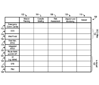
100701 With reference to Figures 1A to 1F, and in accordance with one
exemplary
embodiment, an exemplary mission dispatch process, generally referred to using
the
numeral 100, will now be described. It will be appreciated that the process
100 may
comprise various elements that are optional features that may improve a
dispatch process
for certain applications, such as an emergency medical services (EMS) dispatch
process
for a fleet of medical helicopters. Accordingly, various dispatch processes,
in accordance
with various embodiments, may comprise fewer or additional elements, or
process steps
performed in different sequences, than is presented in the exemplary
embodiment of
process 100.
100711 Indeed, for illustrative purposes, the dispatch process 100 is a
relatively
complex process, and is accordingly described with reference to different
aspects of the
process 100 in Figures 1B to 1F. To this end, Figure 1A generally presents an
overview of
the process 100 comprising aspects related to mission planning 102, compiling
of a mission
1352P-MMD-CADI
Date Recue/Date Received 2022-04-19
briefing 104, risk assessment 106, mission dispatch and monitoring 108, and
mission
debriefing 110, wherein each aspect is respectively schematically illustrated
in Figures 1B
to 1F.
100721 The elements of the exemplary process 100 are further
schematically
represented as generally being performed by or at one of various participants
or elements,
non-limiting examples of which may include an emergency communication center
112, an
operations control specialist (OCS) 114, a web portal 116, a fleet management
platform or
flight risk assessment tool (FRAT) 118, such as the CompleteFlightTM
application
programming interface (API), or user interface (UI) 118, an integrated flight
application
API or UI 120 (e.g. ForeFlightTm), a route alert and/or weather (WX) API 122,
an in-aircraft
display or UI such as a tablet 124, an electronic flight bag (EFB) 126, such
as a tablet, and
an aircraft pilot 128.
100731 To assist the reader, the general schematic structure of the
participants or
elements of the process 100 shown in Figure lA are preserved throughout
Figures 1B to
1F, with exemplary interconnectivity of various process elements across
aspects,
participants, or elements indicated in Figures 1B to 1F. However, as noted
above, it will be
appreciated that various embodiments relate to fewer or additional aspects,
participants, or
elements, depending on the application at hand. For instance, while managing
or
monitoring a fleet of hundreds of helicopters and associated crew may be
improved via a
fleet management API 118 or FRAT (e.g. CompleteFlight), making a go/no-go
decision
for a single private aircraft may not require such an element. Similarly, as
the process 100
relates generally to complex fleet management and monitoring, the OCS 114 and
web
portal 116 may reside in an operations control centre (OCC) 130, while the UI
124, EFB
126, and pilot 128 may generally be associated with an aircraft 132. However,
in
accordance with other embodiments, a flight request may be provided directly
to an aircraft
management platform directly by a user via a web portal 116.
100741 In accordance with one embodiment, Figure 1B schematically
illustrates an
exemplary mission planning aspect 102 of the exemplary process 100. In this
example, an
emergency communications centre (ECC) 112 may submit a proposed flight route A
134
16
1352P-MMD-CADI
Date Recue/Date Received 2022-04-19
and associated mission details 136 to an OCS 114. The OCS may then edit 138
the proposed
route, and/or independently author the route and select 140 an aircraft and
crew for the
mission, which may be submitted via a web portal 116, and wherein route legs,
mission
waypoints, or the like, are generated 142 and/or stored 142 for future access.
The authored
route and associated details 140 may further by registered via a fleet
management API/UI
118, or FRAT, such as CompleteFlight, wherein a mission designator and other
relevant
data may be stored 144 in a database. Similarly, the API 118 may check and/or
select 146
available aircraft and/or crew (e.g. verifying whether a crew is sufficiently
rested via flight
logs, etc.), which, in conjunction with stored route legs and/or waypoint data
142, may be
accessed via the web portal 116 to direct 148 or otherwise confirm 148
aircraft crew
associated with the proposed flight request.
100751 In the exemplary embodiment of Figures 1A to 1F, a briefing 104
may then be
compiled in view of a mission definition 149, as schematically represented in
the diagram
of Figure 1C. In this example, the route and crew data 148 received at the web
portal 116
may be distributed 150 as route information via an API. In this exemplary
embodiment,
distributing 150 the route information comprises pushing route data 152 to the
fleet
management API 118, or FRAT, such as CompleteFlight, pushing route data 154 to
an
integrated API 120, such as a ForeFlight API 120, and pushing route data 156
to a route
and/or WX alert API 122. In accordance with some embodiments, the integrated
flight API
120 may return 158 a flight briefing and/or obstacles associated with the
flight, while
optionally further pushing route data 160 to an in-aircraft Ul 124 or FRAT.
Similarly, the
route alerting and WX API 122 may return 162 flight WX, WX hazards, and/or
flight route
alerts, while optionally further pushing route data 164 to an in-aircraft EFB
126. It will be
appreciated that an in-aircraft UI 124 may comprise a cockpit display, a
computer, or the
like, and may comprise the same of different electronic devices.
100761 In the exemplary process 100 of Figures 1A to 1F, flight
briefings and/or
obstacles 158 returned by an integrated flight API 120, and/or flight WX, WX
Hazards,
and/or flight route alerts 162 returned by a WX alert API 122, may be received
166 via an
API at a web portal 116 for access by the OCS 114 for performance of a risk
assessment
168 and/or evaluation of a mission definition 168 within a risk assessment
aspect 106 of
17
1352P-MMD-CADI
Date Recue/Date Received 2022-04-19
the process 100. Upon an initial review 170, the OCS 114 may deem that a
mission should
not proceed (e.g. due to a WX risk 162, a flight obstacle 158, or the like),
in which case a
risk reduction attempt 172 may be performed. Should the risk reduction attempt
172 fail,
the OCS 114 may reject 174 the mission, with a mission rejection with reasons
176
provided to the ECC 112 within the briefing aspect 104. Should the risk
reduction attempt
172 be successful, the OCS may resubmit an amended plan 178, at which point
the process
100 may continue with a redistribution of route information at process step
150.
100771 Should the initial review 170 pass, the mission definition may be
pushed 180 to
an in-aircraft UI 124 for pilot review 182. Similarly, and in accordance with
some
embodiments, a pilot or crew may optionally also review 184 any alerts,
obstacles, or flight
briefs, and/or optionally review 186 any additional alerts and/or advanced WX
notifications. Upon completion 188 of the pilot review, if any pilot or crew
edits may be
pushed 188 to services to update the flight plan A 134, wherein the process
100 may
proceed or repeat as described above. The process 100 may then further proceed
following
pilot review by pushing any briefing data 192 to the web portal 116 via an
API, wherein
the OCS 114 may perform a final review 194, optionally with OPS director
approval 196.
Should the final review fail, the process may continue with a risk reduction
attempt 172,
as described above. Should the final review 194 be deemed to pass a risk
assessment 106,
the process may then continue with OCS providing mission clearance 198 in a
dispatch and
monitoring aspect 108 of the process 100, as schematically shown in Figure 1E.
100781 During a mission dispatch and monitoring aspect 108, any ECC
initiated route
or mission changes 111 may be included in an updated flight plan B 113.
Similarly, any
pilot-initiated changes 115 and/or OCS-initiated route or mission changes 117
may be
included in the updated plan B 113. Any such updates may further be included
in OCS-
provided mission clearance 108, whereinafter the pilot may conduct the mission
119.
During the mission, any updates or flight data may be sent to or recorded by
121 an
electronic flight back, wherein any terrain or hazard alerts 123 may be
provided in the
cockpit.
18
1352P-MMD-CADI
Date Recue/Date Received 2022-04-19
100791 During the mission, the OCC office 130 may track the flight 125
via a web
portal 116, with additional monitoring 127 of the mission by the OCS. Further,
any flight
deviation alerts 129 may be provided via the web portal, with any deviations
displayed to
the OCS as alerts 131 on, for instance, a map or other interface. The web
portal 116, in
communication with a WX and flight route alerting service 133, may further
identify any
in-flight WX alerts 135 for graphical alerting 137 at the OCS. In-flight WX
alerting 135
may further display any alerts via an obstacle and terrain awareness system
(OTAWS)
display 139, which may further receive and display any alerts from a terrain
and hazard
alerting service 141. Alerting may further comprise mapping any other
identified hazards
143, any alerts of which may be included in any OCS-initiated route or mission
changes
117.
100801 In accordance with some embodiments, the process 100 may further
comprise
a debrief 110 following mission completion 145, as schematically shown in
Figure 1F. In
this example, the pilot may conduct a debrief 147 and submit any documentation
149 via
an in-aircraft UI 124. Completed documentation may then by submitted 151 via
an API to
the OCS for compiling 153 with any flight times and records 155 for forwarding
to a flight
requesting agency 157. Any pilot debrief 147 may also include any flight
recorder mission
data 159 for access via the web portal for flight data monitoring (FDM)
display 161 and
for process evolution into a safety management system (SMS) 163 at the OCS.
100811 In accordance with various embodiments, a flight management platform
may
comprise a number of integrated modules or aspects for various applications.
For example,
and in accordance with various embodiments, a flight management platform may
comprise
weather assessment modules to, for instance, assess a flight request in view
of a weather
forecast. It will be appreciated that, in accordance with various embodiments,
various
weather checks may be performed pre-flight, in-flight, and even post flight.
For example,
a flight request may be initiated via a flight management platform a day in
advance of the
proposed flight. The flight management platform may then periodically assess
the proposed
flight route in view of evolving weather predictions before the scheduled
flight time, such
as every hour up until one hour before the flight. Weather checks may then be
performed
19
1352P-MMD-CADI
Date Recue/Date Received 2022-04-19
every five minutes before the scheduled flight time, before continuous or near-
continuous
monitoring during flight of the aircraft.
100821 In accordance with one embodiment, Figure 2A is a diagram of an
exemplary
flight request weather logic 200. In this non-limiting example, a flight
management
platform may receive a flight request 202 from a customer flight request feed
204.
Similarly, it may access weather data 206 and tracking points 208 from
respective pull
gateways related to, respectively, a weather provider 210 and a tracking,
location, and
events messaging server 212. The platform, in communication with one or more
point
processors 214 and trip processors 216, may communicate tracking data and
flight request
data to perform flight request checks, such as determining that a flight plan
is present 218
for a flight, and/or a geolocation check 220, such as one in which it is
determined if an
aircraft has deviated from the requested flight plan. Similarly, the platform
may assess
whether a particular flight is overdue 222. Any such checks may establish
flight attributes
224 and/or alerts 226.
100831 Similarly, a flight management platform may parse a flight plan 228
based on
flight request data 202, which may then be input into a weather test engine
230, which, in
conjunction with weather data 206, aircraft model specifications 232 (e.g.
input aircraft
model parameters, as further discussed below), and weather threshold
collections 234, may
generate a hazard rating 236, flight request hazard data 238, and/or any
flight plan weather
warnings 240. In accordance with various embodiments, any or all of such data
may be
stored in and/or accessed from one or more databases 242. Such data, as well
as any alerts
226 and weather service data 244, may be displayed to any or all users of the
system via a
graphical display 246. For instance, an in accordance with various
embodiments, flight
routes, aircraft (grounded and/or in-flight), alerts, or the like, may be
displayed via a map
or similar graphical representation accessible in real time via the internet.
Accordingly, and
in accordance with various embodiments, a flight management platform may
further
comprise access to one or more mapping services 248 (e.g. GIS, Google MapsTM,
or the
like) to enable visual display of one or more assets in real time in
accordance with their
location.
1352P-MMD-CADI
Date Recue/Date Received 2022-04-19
100841
Another aspect of a flight management platform that may improve pilot and/or
mission safety is one in which a flight or flights may be monitored as
overdue. For instance,
an aircraft not arriving at an intended destination by an expected time may be
indicative of
an accident experienced on route, wherein one or more people may be injured
and in
immediate need of medical attention. The ability to automatically detect and
provide an
appropriate alert that an aircraft is not at an expected location, or is
overdue following an
expected flight route, may result in the timely provision of medical services
to save lives.
100851
Another aspect of a flight management platform that may improve pilot and/or
mission safety and condition of flight awareness is one in which a flight or
flights may be
monitored for the presence of "notices to airman" (NOTAMs) along or associated
with a
flight plan (e.g. points of departure and arrival, a proposed flight route
and/or segments
thereof, or the like). For example, and in accordance with one embodiment,
Figure 2B is a
diagram of an exemplary flight request weather logic 201 operable to consider
as a source
of flight risk data NOTAMs from an International Civil Aviation Organization
(ICAO)
NOTAM feed 550. In this non-limiting example, a flight management platform may
receive a flight request 202 from a customer flight request feed 204, and may
proceed
similarly and/or with similar process flow to the process 200 of Figure 2A. In
this example,
however, the process 201 further monitors a feed or other source of NOTAMs
250, which
may serve as input to process logic, alert output, or the like, with respect
to a planned flight.
100861 One issue with conventional NOTAM monitoring systems is that, while
some
notices may be along or appear to correspond to a flight path, they may have
little to no
bearing on the actual flight at hand. Other NOTAMs may be general and/or of
minor
interest, while still others may have critical information relative to a
flight. Accordingly,
and in accordance with some embodiments, NOTAMs may undergo one or more
selection
or filtering processes for consideration and/or reporting within flight plan
assessment logic
201.
100871 In
the exemplary embodiment of Figure 2B, a NOTAMs feed 250 may undergo
a first selection or filtering step by a "NOTAM Geo Engine" 252, which may
select for (or
remove from) further consideration NOTAMs that are, for instance, deemed
relevant (or
21
1352P-MMD-CADI
Date Recue/Date Received 2022-04-19
irrelevant) to a geographical region associated with a flight route. It will
be appreciated
that, in some embodiments, such a selection or filtration may be subject to or
consider a
suitable buffer of flight space for, for instance, situations in which a
flight may be rerouted
or diverted.
100881 The embodiment of Figure 2B further comprises logical processing in
the form
of a "NOTAM Filter and Ranking Settings" 254 or like system, which, in some
embodiments, may contain logic or other processing that may prioritise and/or
order
NOTAMs selected by or allowed to pass through the Geo Engine 252. For example,
NOTAMs from the feed 250 and selected by the Geo Engine 252 may be ranked or
sorted
by an importance, proximity, and/or urgency metric or grid. Returned results
may be
collated and prepared for presentation by a display or monitoring service 256,
such as a
NOTAM Prioritisation per Flight Request system 256. Such a NOTAM system 256
may
further provide monitoring services during a flight to detect changes in a
status or alert
system. For instance, the system 256 may detect changes in the NOTAMs present,
or a
Flight Request timing or location. One or both of these functions may ensure
that services
and/or the provided information is relevant to the current Flight Request and
NOTAMs, in
accordance with some embodiments.
100891 It will be appreciated that, in some instances, a Flight Request
may change
many times. For example, flights may be cancelled, given a new destination,
require a
Return to Base, dispatched to a new pickup or drop off points, or the like.
Accordingly,
flights may be dynamic in any number of manners. To this end, and in
accordance with
various embodiments, a NOTAM Prioritisation service 256 may be constantly on
the watch
for changes, and adapt quickly, given modern computer techniques. Any such
changes may
be given as, for instance, messages having associated Priority levels to
Operational Control
Specialists or Flight Followers, and may be "pushed out" as soon as they are
prepared. In
the exemplary embodiment of Figure 2B, such messages may be delivered via a
"NOTAM
Notices & Alerts" map service 258, and may be made available to users of the
network
(e.g. any end users of the various aspects of the process 201) via, for
instance, a Mission
Web Map Service 246.
22
1352P-MMD-CADI
Date Recue/Date Received 2022-04-19
100901 In accordance with various embodiments, logic for determining a
NOTAM
prioritisation may relate to various parameters. For example, a first
embodiment may
consider an "urgency" parameter. While such a parameter may be useful for some
applications, other applications may additionally or alternatively include a
"proximity"
parameter, which may be more useful and/or comprise a different number of
gradations
(e.g. in comparison to some urgency parameters, which may be reported at the
same
urgency level if valid).
100911 Moreover, some embodiments relate to prioritisation based on one
or more of a
collection of specific key word searches (e.g. customer-specific keyword
searches,
keyword searches from different customers, or the like), phrase searches, time
filters,
elevation filters, an "Impact to Flight" rating, which may be customisable
and/or tailored
in accordance with various parameters, weights, and/or formulae, a "Real Time
Hazard
Watch" on NOTAMs observed throughout the duration of a flight, or the like. In
accordance with some embodiments, such a process may be performed before
takeoff of a
flight (e.g. during a Pre-Flight Briefing), and/or may run continuously during
a flight in the
event of a new NOTAM being issued during a flight. In accordance with some
embodiments, presentation of such NOTAM data may be designed such that a list
of
NOTAMs (e.g. the entire list thereof) received from an ICAO feed 250 is re-
ordered, and
wherein NOTAMs are placed, displayed, or pushed based in part on an associated
"impact
to flight" rating. Furthermore, and in accordance with some embodiments, if an
emergency
is noted, an "impact to flight" rating may be re-processed to take into
account the new
scenario, which may in turn alter the significance of NOTAMs along the route.
Alerts may
additionally be generated for Operational Control Specialists and Flight
followers to alert
them of any changes, and highlight such changes, in accordance with some
embodiments.
100921 In accordance with various embodiments, additional tools may be
provided to
customise NOTAMs prioritisation. For example, a "Focus" tool may be provided
that
allows manual entry of keywords or selection from a dropdown menu (e.g. a
dynamic
dropdown menu populated with the last ten unique keywords) to change the
prioritization
of importance/proximity graphing of NOTAMs. For instance, a user may select
the word
"towers", and have NOTAMs relating to "towers" given a higher priority. In
accordance
23
1352P-MMD-CADI
Date Recue/Date Received 2022-04-19
with yet other embodiments, prioritisation processes may further comprise
modifiers (e.g.
up to three or more modifiers). Furthermore, in some embodiments, provision
may be made
for a "Print Prioritized List" for a plain text (e.g. Courier font) output of
all NOTAMs
associated with or along a flight. In accordance with yet other embodiments,
tools may be
further provided for a graphical layer displayed on a map to select various
aspects. For
example, a selectable aspect may comprise, without limitation, a "level of
importance"
slider corresponding to a level of importance of NOTAMs that are shown (e.g.
"All", "Only
Important", or the like), a "proximity" slider (e.g. to selectively allow
NOTAMs
corresponding to near and/or far distances), or the like.
100931 Such functionality may, in accordance with some embodiments, address
various
important aspects of flight safety. For example, depending on where a flight
is planned, the
type of aircraft used, and the applicable rule set (e.g. instrument or flight
rules) associated
with the flight, the "Importance-Proximity" grid representation of NOTAMs
along a flight
path may change. Accordingly, user-selectable bias controls may improve NOTAMs
ranking or ordering, ultimately improving flight safety and decision-making.
For example,
a medical transport pilot may be cognisant of a low ceiling for a particular
flight. They may
thus prefer to have NOTAMs filtered such that tower-related NOTAMs (e.g.
changes to
towers in the area) are highlighted. In accordance with some embodiments, the
pilot may
thus select "Towers" as a NOTAMs feature of interest, to which a NOTAMs engine
may
accordingly respond, such as with "there are no Tower-related NOTAMs along the
route",
"There are three tower-related NOTAMs along the route", or the like. In
accordance with
some embodiments, a NOTAMs engine or system may further present or enable
additional
controls, such as "show on map", "print", or the like.
100941 Various embodiments of a flight management platform relate to the
provision
of alerts of aircraft that may be overdue for mission completion. To this end,
Figure 3 is a
diagram of an exemplary overdue alert decision tree, wherein exemplary logic
steps are
schematically represented in the context of an exemplary mission beginning
with the with
the submission of a flight plan 302.
24
1352P-MMD-CADI
Date Recue/Date Received 2022-04-19
100951 Upon receipt of a flight plan 302, a flight management platform
may determine
that the flight plan 302 is not active 304. If the aircraft associated with
the flight plan 302
is already in or known to 306 the flight management system, no events may be
logged 308.
Alternatively, if the aircraft is not recognised, no action may need to be
taken 310.
Similarly, if the received flight plan 302 is associated with an active flight
312, but the
aircraft is not registered 314 by the system, a general error notification 316
may be
provided, without specifically logging an entry within the system.
100961 In accordance with some embodiments, monitoring of a known
aircraft with an
active flight plan may be provided via, for instance, graphical display 318 of
a map and an
icon representing the aircraft, as well a representation the associated flight
plan. Indicators
of the aircraft status may be provided based on, for instance, tracked motion
of the aircraft.
For instance, if the aircraft tracking 320 is live but no motion is detected,
the aircraft icon
may remain motionless 322. Detected motion may be indicated, via, for
instance, animation
of rotors 324 on the icon representing the aircraft. In the absence of, for
instance, a
departure signal 326, the graphical display may need not be changed 328.
Alternatively, if
tracking motion or a departure is detected 326, then a timer may be initiated
330. In
accordance with some embodiments, an overdue timer 330 may similarly be
initiated upon
receipt of a manual departure message 332 at the platform. Either path may
therefore
signify that a pilot has begun a mission 340. Should such a manual departure
message not
be received, the platform may maintain all displays (i.e. no change 334). In
the event that
such a manual departure message arrives late 336, a message to that effect may
be logged
338, wherein the timer may further be activated/reactivated 338, and at which
point, the
pilot may be assumed to be flying the mission 342.
100971 While conducting the mission, the platform may check or receive
data related
to the overdue timer 344. Based on when the timer was initiated, it may be
such that the
expected mission time is still within the bounds of what was expected based
on, for
instance, the submitted flight plan 302 (e.g. known departure point, mission
time, distance
to a landing zone, etc.). In such a scenario, the platform may continue
tracking 346 the
flight and overdue timer. Should the timer expire prior to receipt of a signal
that the mission
has been completed, however, the platform may provide an alert 348 in the form
of an
1352P-MMD-CADI
Date Recue/Date Received 2022-04-19
alarm 348, a colour change 348 of the display related to the overdue flight,
or the like, so
to notify a OCS or like body that a flight is overdue and that there may be a
safety concern.
In the meantime, if no signal is received indicative of a flight returning,
such as a manually
submitted arrival 350, the alert or alarm may continue 352. Similarly, if no
tracking points
354 may be identified, no position points have been received from a manual
submission
356, and/or no message 358 has been received, such that from a cockpit
messaging system,
such as a mission control terminal (MCT), the alarm may continue 352.
Conversely, if such
position points 354 or 356, or a MCT message 358 has been received, the event
may be
logged 360, and the overdue timer may restart 360, optionally with a new value
for the
overdue timer (e.g. a value corresponding to 20 % of the total mission time
based on the
status of the mission, or the like). On the other hand, should an arrival be
received 350 by
the platform after an alert 348 has been provided, data related to the arrival
and alert may
be logged 362, while the mission may be noted as completed 364 and the mission
monitoring discontinued 366.
100981 In accordance with various embodiments, aircraft-specific data may
improve
various mission dispatch processes, assessments related to flight plan with
respect to
weather or hazards, flight monitoring, or the like. For example, consideration
of icing or
other route hazards may be different for a helicopter performing a rescue
mission than for
a private tourism flight in a Cessna, and may accordingly be assessed,
monitored, and/or
reported differently. Accordingly, various embodiments relate to processes and
systems
that are operable to receive as input data related to an aircraft associated
with a flight plan.
To this end, and in accordance with various embodiments, Figures 4A to 4C show
an
exemplary user interface for inputting aircraft-specific data related to a
submitted flight
plan. In accordance with other embodiments, an array of input forms 400 may
comprise
fields for inputting template data related to, for instance, a class of
aircraft or mission routes
that may be selected for future flight plans. For instance, and without
limitation, an OCS
responsible for a fleet of aircraft may have a plurality of similar aircraft
with similar
mission objectives that are repeatedly carried out on demand. The organisation
may further
have several types of aircraft, each typically carrying out similar missions.
Accordingly,
.. the input interface 400 of Figures 4A to 4C may comprise an early process
step of a fleet
setup within a flight management platform to, for instance, rapidly input
flight parameters
26
1352P-MMD-CADI
Date Recue/Date Received 2022-04-19
associated with different aircraft to a flight management platform for rapid
selection at a
later time (e.g. in an emergency situation, such as in response to a dispatch
request for an
emergency rescue).
100991 In the exemplary embodiment of Figures 4A to 4C, asset model
entry forms 400
may comprise the entry of data related to, for instance, an aircraft type 410,
general aircraft
parameters 420, weather thresholds 430, flight plan thresholds 440, mission
thresholds 450,
general asset information 460, or the like. Non-limiting examples of aircraft
types may
include, for instance, a helicopter, an engine type or number, a wing or
propeller
configuration, or the like. General aircraft parameters 420 may include, for
instance, an
aircraft manufacturer, an aircraft model, an average cruise speed, or the
like.
1001001 In accordance with various embodiments, weather threshold parameters
430
and/or flight plan thresholds 440 may be similarly input for all aircraft, or
may be specific
to each aircraft type, model, or the like. For instance, the exemplary input
form 400 of
Figure 4A allows for input of weather-related thresholds 430 related to the
anticipated
length of time ahead of the aircraft along a flight route, a ground radius,
and a corridor
width and height, and a default flight level in which to check weather, as
well as a medium
and critical alert template in accordance with which a platform may provide
alert. In
accordance with one embodiment, such parameters may be requested for, for
instance, all
aircraft types. In accordance with another embodiment, different weather
threshold
parameters 430 may be requested for different aircraft types.
1001011 In the exemplary embodiment of Figures 4A to 4C, weather threshold
parameters relate to a flight corridor in which to assess weather at a
particular time, or over
a particular time window (e.g. the takeoff time, the duration of the flight,
the expected time
at which an aircraft will be in a particular location, or in a particular area
or volume of
space based on flight plan parameters, the takeoff time and average cruise
speed, or the
like). For example, and in accordance with one embodiment, a pre-flight check
may
comprise assessing, based on a takeoff location, a landing location, and/or
any locations of
interest in between, including a flight corridor corresponding to the
intervening volume of
space based on a corridor width and height and a default flight level, a
present risk
27
1352P-MMD-CADI
Date Recue/Date Received 2022-04-19
assessment of weather throughout the entire predicted volume of space. In
accordance with
another embodiment, a flight plan assessment may comprise segmenting a
predicted flight
route into segments of a designated length (e.g. 5-, 10, or 20-minute
intervals of flight
based on an average cruise speed, every 5 km, 10 km, and/or 20 km of a
predicted flight
path, or the like), and assessing a hazard risk based on a predicted time at
which the aircraft
will be within that flight route segment, for example, within a flight
corridor (airspace
weather volume height and width thresholds) defined for that segment.
1001021 In accordance with different embodiments, different flight plan
segment
airspace volumes may be defined depending on the types of thresholds applied
thereto (e.g.
rectangular and/or cylindrical coordinate thresholds) as well as the type of
segment being
considered. For example, a take-off or projected landing flight segment may
have
associated therewith a substantially vertically oriented airspace or corridor
to address the
rise / decent of the aircraft through various airspace elevation levels and
corresponding
weather patterns, whereas a cruising altitude flight segment may have
associated therewith
a substantially horizontal airspace segment volume or corridor to reflect
travel mostly at or
about a cruising altitude at cruising speeds. These and other flight plan
airspace segment
volume thresholds, limits or the like may be considered to fall within the
general scope and
nature of the present disclosure.
1001031 In the exemplary embodiment of Figures 4A to 4C, weather-related
thresholds
430 further comprise alert templates related to medium and critical risk alert
templates.
Such templates may, in accordance with some embodiments, be preset based on,
for
instance, predetermined risk thresholds (as shown in Figures 4A to 4C), or may
be
manually entered in similar forms. For example, and in accordance with one
embodiment,
such thresholds may be inherent in a platform as dictated by, for instance,
jurisdictional or
oversight standards for particular aircraft types. In accordance with other
embodiments, a
flight management platform may provide form fields similar to that 400 of
Figures 4A to
4C for manual input of, for instance, medium and critical alert templates.
1001041 Again with reference to Figures 4A to 4C, an asset template 400 may
comprise
the entry of data related to flight plan thresholds 440. In this example,
flight plan thresholds
28
1352P-MMD-CADI
Date Recue/Date Received 2022-04-19
comprise, inter alia, data related to a flight plan deviation buffer. This may
relate to, for
instance, the amount of space (or predicted flight time) that an aircraft may
deviate from
an expected flight route before an alert may be generated for a user of the
flight
management platform. Similarly, flight plan threshold form fields 440 may
comprise
additional elements, such as a training flight plan deviation threshold, or
the like, which
may allow for, for instance, more or less buffer space (or time) for deviation
from a flight
plan based on acceptable deviations from a predicted flight route during a
training exercise.
1001051 Various other exemplary asset characteristic fields 400 are
illustrated in Figures
4B and 4C. For instance, Figure 4B illustrates exemplary mission start
thresholds 450
comprising speed and distance thresholds that are to be assumed by a flight
management
platform at mission outset. Figures 4B and 4C further show general asset
characteristics
460, non-limiting examples of which may include rates of climb, maximum range
of the
aircraft, weights of the aircraft (e.g. max weight, max gross weight, average
basic weight,
empty weight, operating weight), total payload, external slight load, fuel
capacity, unusable
fuel, fuel consumption (e.g. general consumption, consumption at climb,
cruise, and/or
descent), the number of passenger seats, the aircraft width, length, height,
and/or diameter,
or the like. It will be appreciated that such inputs are provided as examples,
and that various
embodiments relate to a flight management platform that may include fewer or
more inputs,
depending on the application. For example, one embodiment relates to a flight
management
platform operable to access the asset parameters shown in Figure 4A, while
those presented
in Figures 4B and 4C may not be required for, for instance, a helicopter
rescue mission
monitoring application.
1001061 It will be appreciated that additional or alternative form fields may
be included
with an asset model template 400, in accordance with different embodiments.
Further,
various embodiments relate to the customisation of asset models performed by a
user of a
flight management platform, by a governing or regulatory body associated with
flight
applications, or by an authority of the flight management platform itself.
Asset model entry
forms may further comprise raw data entry fields comprising fixed or optional
unit entry
fields. For example, various parameters may be entered in units of time,
space, or the like,
depending on the parameter or application of interests. Entry fields and/or
associated units
29
1352P-MMD-CADI
Date Recue/Date Received 2022-04-19
may further comprise, for instance, drop-down menus, or the like, for instance
if only
certain parameter sets (e.g. alert templates, acceptable corridor widths, or
the like, are
permitted. Further, various embodiments relate to thresholds or asset type
definitions that
are fixed, or may be variable based on, for instance, user input, flight
monitoring
authorities, or as a function of a flight or weather status. For instance, a
volume of airspace
to be considered (e.g. a flight corridor) may comprise a variable cross
section of interest to
consider in view of a weather forecast based on a weather status (e.g. stormy
or all-clear),
or an amount of time until it is expected that an aircraft will be in a
particular flight segment.
For instance, a pre-flight check may comprise assessing a weather risk in the
volume of
space that is twice that indicated by the parameters in the asset model entry
form 400, while
an in-flight assessment may limit risk assessment to the volume of space
indicated by the
asset template 400, further as a function of the predicted time at which the
aircraft will be
in a particular segment of a flight route.
1001071 With reference now to Figure 5, and in accordance with various
exemplary
embodiments, an exemplary flight management user interface, generally referred
to using
the numeral 500, will now be described. While, in some embodiments, the
exemplary
interface 500 may relate to one that is employed in any of the embodiments
described above
(e.g. a web portal 116 of Figure 1, the Mission Web Map Service 246 of Figure
2A or
Figure 2B, the aircraft tracking and flight plan tracking interface 318 of
Figure 3), various
embodiments may additionally or alternatively relate to a graphical interface
500 for
assessing a flight plan, route, or risk in advance of a requested flight (e.g.
upon submission
of a flight request that includes takeoff and/or destination point(s), times
associated
therewith, aircraft types, and/or various other parameters input via, for
instance, an asset
model 400), monitoring a flight during performance of a mission, reviewing a
flight post-
mission, or the like.
1001081 In the exemplary embodiment of Figure 5, the interface 500 comprises a
list of
aircraft 502 associated with a user. In accordance with different embodiments,
the list may
comprise a single aircraft (e.g. the aircraft for which a pre-flight check is
being performed),
or a plurality of different aircraft (e.g. hundreds of aircraft), optionally
of different types,
for which a user or organisation is responsible (e.g. an OCC responsible for a
fleet of
1352P-MMD-CADI
Date Recue/Date Received 2022-04-19
emergency response helicopters and other aircraft). In embodiments related to
the latter
notion, the list of aircraft 502 may comprise a list of active aircraft (e.g.
a list of aircraft for
which flight requests have been submitted, whether or not they are actively in
flight), or a
list 502 of all associated aircraft, whether or not there is a flight request
and/or flight plan
associated therewith.
1001091 In accordance with some embodiments, the interface 500 may further
comprise
a summary 504 of all aircraft associated with the user, or a summary 504 of
active aircraft
associated with the user. In this example, the summary 504 comprises a list
504 of aircraft
that are currently moving, stopped, those for which there is no fix, those for
which there is
a weather warning (e.g. a weather hazard associated with the base in which the
aircraft is
located, and/or a weather risk associated with an aircraft in flight, or
predicted to be in
flight based on a flight plan and/or request, or the like), and those which
have deviated
from an anticipated flight route. The summary portion of the flight management
interface
500 further comprises, in this example, a summary 506 of active assets (e.g.
aircraft with
active flight plans 506), and an alert summary 508 graphically showing a
distribution of
aircraft for which there are presently alerts. In this example, and in
accordance with various
embodiments, such summaries may be further refined, for instance by respective
colours
and/or via another visual cue (e.g. graphical bars, as shown in summary
indicators 506 and
508), to show, at a glance, a general status individual aircraft, or a fleet
thereof. For
example, the summary of active assets 506 indicates, in conjunction with the
general
summary 504, that 9 aircraft are presently moving, while 12 assets are
stopped. Similarly,
the alarm summary 508 indicates that there are presently 33 aircraft for which
there is a
weather alert, and that there is 1 aircraft which has deviated from a
predicted flight route.
1001101 The exemplary embodiment of Figure 5 further comprises a list of drop-
down
menus 510 with which a user (e.g. an OCS) may quickly access (e.g. visualise
on screen,
bring up alerts related to, or the like) aircraft of interest. For example,
and in accordance
with one embodiment, a drop-down menu 510 may allow a user to quickly navigate
to an
aircraft that has deviated from an expected flight route, or to a flight plan
for which there
has been a weather alert. In accordance with some embodiments, such subsequent
drop-
down menus 510 may allow for further refinement. For example, the drop-down
menus
31
1352P-MMD-CADI
Date Recue/Date Received 2022-04-19
510 of Figure 5 may, from left to right, allow a user to filter flights by
alert type (e.g.
weather-related, flight deviation, etc.), and further by specific flight plan
or aircraft.
1001111 In accordance with various embodiments, the flight management
interface 500
may further comprise a visual map layer 512. In accordance with some
embodiments, a
map interface may be provided by or otherwise accessed from a map service,
such as a
GIS-based application, or Google Maps. Accordingly a flight management
platform, in
accordance with various embodiments, may interface with various mapping
platforms to
provide a map layer 512 within an interface 500. In the exemplary embodiment
of Figure
5, the map layer 512 comprises a map overview of the region around a flight
plan associated
with the aircraft 514 highlighted in the list of aircraft flight plans 502
associated with that
user. While the map region 512 is set to a scale in Figure 5 so to show a
single flight plan
associated with the highlighted flight 514, it will be appreciated that such a
graphical
interface is scalable to show larger or smaller regions, for instance via
scrolling with a
mouse wheel, or clicking via zoom icon or scale bar on the interface 500, or
the like, to
expand/contract the scale that is being viewed on the map 512. For instance, a
user may
zoom outwards from the map scale shown in Figure 5 to graphically display a
portion of
or all active flight plans on the map 512, depending on the application or
particular goal of
the user. Accordingly, such an interface 500 allows a user to readily monitor
any one or
more flight and/or flight plans in real time. For instance, a user may be
presented with a
map 512 comprising a general overview of all flights 502, from which the user
may select
an aircraft, flight plan, and/or region of interest by clicking on a
particular asset in the list
502 of all assets, by sorting/filtering using drop-down menus 510, and/or by
zooming in/out
on the map 512 as needed.
1001121 For example, the map 512 of Figure 5 shows a zoom on the active flight
route
516 associated with the highlighted aircraft 514 of the list of assets 502. In
this example,
and in accordance with various embodiments, the flight route 516 is divided by
the flight
management platform into segments based on a submitted flight request. In
accordance
with various embodiments, a flight request may comprise a JSON or other format
known
in the art for including relevant flight data, such as a takeoff time and
location, associated
waypoints, mission details, or the like. For example, and in accordance with
one
32
1352P-MMD-CADI
Date Recue/Date Received 2022-04-19
embodiment, a flight request of the following form may be received or accessed
by a flight
management platform:
{"manifest number": 5972, "program": "Air Flight Dispatch", "flight status":
"Active",
"estimated depart date": "2020-11-09T15:40:43+00:00", "estimated eta": "2020-
11-
09T18:42:43+00:00", "request date": "2020-11-09T14:55:47+00:00", "waypoints":
[{"description": "LZ.", "title": "Hope Med Center", "longitude": -108.261362,
"ground time": 0, "offset": 0, "latitude": 32.797753, "departed date": "2020-
11-
09T15:40:43+00:00", "arrived date": " }, {"description": "LZ.", "title":
"Memorial Med
Center - Kenaston", "longitude": -106.735333, "ground time": 69, "offset": 37,
"latitude":
.. 32.291667, "departed date": "2020-11-09T17:27:31+00:00", "arrived date":
"2020-11-
09T16:18:21+00:00"}, {"description": "KDMN - DEMING MUNI AIRPORT", "title":
"KDMN", "longitude": -107.719, "ground time": 19, "offset": 135, "latitude":
32.262333,
"departed date": "2020-11-09T18:17:13+00:00", "arrived date":
"2020-11-
09T17:57:20+00:00"}, {"description": "LZ.", "title": "Air Flight Base
32(base)",
"longitude": -108.261333, "ground time": 30, "offset": 182, "latitude":
32.797833,
"departed date": ", "arrived date": "2020-11-09T18:45:31+00:00"}], "tail
number":
"N543A", "is active": "yes", "pilot name": "Harry Pendergast", "comm spec
name": "Jill
Tundress", "dispatch number": "4850", "risk score": 42, "reason": "update",
"base": "NM,
Bangor", "ocs name": "Jack Callister", "manual_positions": [], "flight type":
"Hospital
Flight", "api key":
"Dispatch.helicopter", "flight request id":
"2N276NV806NDFGTY5463245"1
1001131 In the example of Figure 5, the flight request comprised a flight plan
in turn
comprising a takeoff and landing location 518 with intervening landing and
takeoff
positions 520 and 522. The flight management platform, in accordance with
various
embodiments, utilised this information, in conjunction with aircraft data
(e.g. that
entered/accessed via a module asset editor 400), to automatically generate a
flight route
512 partitioned into sequential flight segments 524, 526, 528, 530, and 532.
While these
segments were automatically generated by the platform using the flight plan
information
and parameters 400 associated with the aircraft, it will be appreciated that
such segments
may be altered, or manually input by a user (e.g. an OCS, a pilot, or the
like), to generate
33
1352P-MMD-CAD1
Date Recue/Date Received 2022-04-19
or adjust flight segments based on, for instance, the application at hand
(e.g. a regularly
scheduled helicopter route, a specific rescue mission, or the like), or based
on a predicted
weather forecast displayed in a map overlay 512 (e.g. adjust segment length
depending on
a high probability of hazardous weather conditions on one or more segments of
the flight
route 516).
1001141 In the example of the Figure 5, the present position of the aircraft
is indicated
by the aircraft icon 534. However, it will be appreciated that the flight
route 516, segments
thereof, any alerts associated with the flight route, or the like, may be
assessed or evaluated
pre- and/or post-flight, for instance via stored values associated with the
flight request
and/or weather mapping. Nevertheless, in this example, the present position of
the aircraft
534 is correlated with the flight segment 528 of the flight route 516.
1001151 Based on the present time and/or position of the aircraft, and in
accordance with
some embodiments, the flight route, and/or all segments 524, 526, 528, 530,
and 532
thereof, may indicate a status thereof in view of the aircraft position 534
via the graphical
representation of the flight route 516. As the platform has access to weather
and hazard
alerts and/or data, as described above, the platform may assess, in accordance
with various
embodiments, any or all segments of the anticipated flight route 516 for
potential hazards,
and, in accordance with various embodiments, may indicate potentially
hazardous
segments and/or routes via the indicated flight route 516 or segments thereof.
In this
example, the flight route, and all segments thereof, have been assessed by the
flight
management platform, based at least in part on weather/hazard data and the
thresholds
associated with that aircraft (e.g. based on asset information 400 associated
with that
aircraft), as being low risk (i.e. "all-clear"). This may be indicated by, for
instance, the
colour scheme or insignia representing each flight segment (e.g. green for low
risk, yellow
for medium risk, red for critical risk), and/or the absence of alerts
presented to the user by
the interface 500. In this example, the "all-clear" signal is further
indicated by the detail
window 536 when the flight plan associated with the aircraft 514 was hovered
upon via a
mouse, although various embodiments relate to such alerts being automatically
generated
or brought to the forefront of the interface in the case of, for instance, a
weather alert or
.. NOTAM associated with a flight plan.
34
1352P-MMD-CADI
Date Recue/Date Received 2022-04-19
1001161 Further, and in accordance with some embodiments, the aircraft icon
534
position with respect to the flight route 516 indicates the aircraft has
completed segments
524 and 526 of the flight route 516 (i.e. it has traveled counter-clockwise
about the planned
route 516). Accordingly, the first route segment 524 has been indicated as
complete (and
is no longer monitored), as shown by the lack of hazard indicator (e.g. a
black band, rather
than a colour indicator) along the segment 524. However, and in accordance
with various
embodiments, the more recently completed segment 526, as well as the current
segment
528, may continue to be monitored by the flight management platform. For
instance, it may
improve aircraft safety to continue to monitor recently completed segments, as
well as
intervening landing zones 520, should the aircraft need to be rerouted in the
case of a
detected hazard.
1001171 The graphical interface 500 further illustrates, in accordance with
some
embodiments, current attributes and associated values 542 of the selected
aircraft 514. In
accordance with various embodiments, such aircraft attributes 542 may include
aspects
related to the selected aircraft name, the last recorded time, aircraft state,
current position
(e.g. latitude and longitude), speed, heading, and/or altitude, or the like.
1001181 The interface 500 further shows, in accordance with various
embodiments, user
interaction fields 538 and 540 representing togglable user display preference
fields related
to, respectively, fleet assets and map layers. Exemplary display options may
include, for
instance, asset flights, asset tails, asset animations, asset labels, weather
advisory areas,
asset locations, map night view, Google Terrain, NOTAMs, or the like. It will
further be
appreciated that various display options may be offered depending on, for
instance, the
application at hand, or a view mode that the user has selected in various
other aspects of
the interface 500.
1001191 For example, and in accordance with various embodiments, the exemplary
interface 600 of Figure 6 shows a graphical representation of a flight plan
610 comprising
not only the anticipated flight route 612 (similar to the flight route 516 of
Figure 5), but
also the weather advisory area 614, as the user has activated this layer in
the display
properties fields portion 616 of the interface 600. That is, the weather
advisory area 614
1352P-MMD-CADI
Date Recue/Date Received 2022-04-19
being monitored (e.g. the regions 614 designated based on the aircraft weather
monitoring
thresholds 430, such as the air corridor associated with that aircraft) is
indicated by the
rectangular sections 614 surrounding the segments of the flight route 612
generated by the
flight management platform. It will be appreciated that while such a graphical
representation of weather advisory or other alert monitoring areas 614 may be
helpful for
a user (e.g. an OCS) in visually assessing hazard risks, such layers may serve
as visual cues
that may be optionally layered on other graphical interface layers, and that
various flight
monitoring aspects may comprise different areas or volumes of space that be
handled
differently with respect to hazard assessment. For example, while the volume
of space
represented by rectangles 614 on the graphical interface 600 may represent
volumes of
space being compared with temperature or dew point forecasts for a particular
segment(s)
of a flight route, airspace corridors being assessed for storm forecasts or
terrain hazards
may comprise a greater or lesser volume than that graphically represented by
the weather
areas 614. Further, and in accordance with various embodiments, weather
advisory areas
614 or NOTAMs may optionally displayed or removed, depending on the preference
of the
user. For example, in the graphical interface 600 of Figure 6, the user has
enabled the
"Weather Advisory Areas" toggle in the "Fleet" view of asset allocations 616,
and may
simply disable the toggle as when desired.
1001201 In accordance with various embodiments, Figure 7A shows another
exemplary
aircraft flight plan assessment via a flight management platform interface
700. In this
example, both the flight route 710 calculated by the platform using a flight
request
comprising takeoff 712 and landing 714 points, as well as the alert areas 716
employed by
the platform to monitor potential risks associated with the flight plan, are
shown. However,
in comparison to the "all-clear" indicator associated with the flight route
516 of Figure 5,
both the flight route 710 and alert area 716 boundary indicator 718 indicate,
via a colour
scheme of their respective graphical insignia, indicate that there is a hazard
associated with
the flight route 710. In this example, the user was quickly able to
graphically navigate to
the at-risk flight route 710 based on the drop-down menu 720, which
automatically and
clearly indicated the severe weather alert. In accordance with some
embodiments, the user
may further by able to view a more detailed report 722 of the alert by
clicking on or
36
1352P-MMD-CADI
Date Recue/Date Received 2022-04-19
hovering over any of the components of the graphical representation of the
aircraft, the
flight route 710, or the like, as shown in Figure 7B.
1001211 Further highlighting the versatility of a flight management platform
for
assessing potential flight hazards, and/or a severity level or a variety
thereof, and in
accordance with various embodiments, Figure 8 shows yet another flight
management
interface 800 monitoring a flight route 810. In this example, a flight request
was first
submitted indicating that the aircraft was departing from the takeoff location
812 and would
land and subsequently take off at, in order, locations 814 and 816, before
returning to the
original base 812. Upon receipt of the flight request, the flight management
platform,
having access to known asset information (e.g. asset information 400),
automatically
generated an anticipated flight route 810 and hazard assessment areas (not
shown), which
was automatically segmented into sequential flight legs or segments 818, 820,
822, 824,
826, and 828.
1001221 In this example, the present aircraft position 830, as determined
from, for
instance, GPS measurements received by the platform from an in-aircraft
instrument,
shows that the aircraft is currently traversing the segment 826, having
traveled counter-
clockwise around the anticipated route 810. Again, this example highlights how
segments
818, 820, and 822, having already been completed (e.g. due to an elapsed time
since
traverse of the respective segments, and/or because there is at least one
landing base along
the flight route in between the aircraft position 830 and the respective
segments), are no
longer monitored, as indicated by the lack of an alert or indication along the
respective
flight route segments (e.g. no insignia or colour-coding scheme associated
with the flight
route segment). Ahead of the aircraft 830, there is an "all-clear" indication
interpreted from
the colour of the displayed flight segment 828. However, while the current
flight segment
826 is generally indicated by an all-clear colour scheme with respect to
weather hazards
(e.g. the upper region of segment 826), the return route 832 (i.e. the
expected route should
the aircraft 830 return to the previous landing space 816) indicated via an
additional colour
indicia 832, as well as a highlighting 832 of the return route to the landing
zone 816, shows
that there is a potential risk that is not weather-related. Indeed, the flight
management
platform, having automatically identified from data associated with another
flight 834 (e.g.
37
1352P-MMD-CADI
Date Recue/Date Received 2022-04-19
the flight position 834, as well as route data associated therewith), has
provided an alert
related to a potential hazard corresponding to the interference between the
currently
displayed flight route 810 and the nearby flight 834. Accordingly, the flight
management
platform has indicated via the interface 800 that there is a potential flight
risk associated
with the flight route 810, as there is the potential for a dangerous situation
should the
aircraft 830 require a return to base at the prior landing position 816.
1001231 Further, and in accordance with various embodiments, the second-most-
recently traversed flight segment 824 yet further indicates via a colour
indicium associated
with that segment 824 that there is a medium weather advisory associated with
the segment
824. In this example, this medium weather advisory was quickly located using
the drop-
down menu item 836 and sorting for medium weather advisories, bringing the
flight route
810 to the forefront of the graphical interface 800 for review within two
mouse clicks.
1001241 Accordingly, a flight management platform is operable, in accordance
with
various embodiments, to automatically assess a wide variety of potential
flight risks.
Moreover, a flight management platform, in accordance with various
embodiments, readily
interfaces with a variety of data sources to automatically bring to the
attention of a user the
nature of such risks, as well as provide relevant and detailed data related
thereto to the
user's attention. Non-limiting examples of potential flight risks, including a
severity
thereof, that may be monitored, may include smoke, air traffic, birds, cold
fronts, warm
fronts, occluded fronts, freezing level, wind gusts on the ground, wind value
on the ground,
flight category (e.g. low instrument flight rules, instrument flight rules,
marginal visual
flight rules, visual flight rules, or the like), radar category (e.g. rain,
freezing rain, snow),
radar reflectivity (e.g. in dBm), dew point spread, visibility, ceiling,
turbulence, significant
meteorological information (e.g. SIGMETs), storm tracks (e.g. from radar
measurements),
storm types (e.g. mesocyclone, heavy rain, hail, severe hail, tornado, etc.),
or the like.
Similarly, a flight management platform may utilise any accessible METAR
information
reported by a station, as well as any information reported in a terminal
aerodrome forecast
(TAF), the scope of which will be appreciated by the skilled artisan. Various
embodiments
therefore further relate to a platform that is readily communicable with data
sources related
38
1352P-MMD-CADI
Date Recue/Date Received 2022-04-19
to flight risks (e.g. via use of appropriate API languages or queries,
programming
languages, or the like).
1001251 Furthermore, and in accordance with various embodiments, any or all of
these
flight risks may be parsed by time (e.g. in the future), and/or by altitude
(when the attribute
is not a surface attribute). Accordingly, a flight management platform, in
accordance with
various embodiments, may compare an expected flight path as a function of time
(i.e. where
the aircraft is expected to be at times in the future) with a predicted hazard
forecast (e.g.
risk of lightning or rain) for the predicted flight path at the time in the
future corresponding
to when the aircraft is expected to be there. Similarly, the flight management
platform may
compare the flight route (as a function of time) with that of other known
aircraft in the area
to assess a potential flight risk due to crowded airspace, also as a function
of time, in
accordance with some embodiments.
1001261 In accordance with yet other embodiments, a flight management platform
may
further be operable to assess whether an aircraft has deviated from an
expected flight route,
and to report on any such deviations. For example, and as described above, an
asset
definition 400 may comprise data related to how far a particular aircraft or
asset type may
deviate from an expected flight path before generating an alert to a user of
the platform.
Figure 9 shows, in accordance with some embodiments, how a flight management
platform
may address such an excessive deviation from an anticipated flight path, and
display data
related thereto via a graphical interface 900.
1001271 In this example, the aircraft 910 was observed to deviate from an
expected flight
route 912. In particular, the aircraft 910 deviated from the flight segment
914 automatically
identified by the flight management platform upon receipt of a flight request,
and instead
took the flight path 916, as identified using real-time measurements of
position and heading
of the aircraft indicated by point-like arrows 918. While such a situation may
arise due to
any one or more complications experienced during a flight, this deviation
likely arose due
to a weather risk associated with the flight path 912, as indicated by the
weather overlay
included in this view of the interface 900 and comprising medium-risk weather
conditions
920, in accordance with one embodiment.
39
1352P-MMD-CADI
Date Recue/Date Received 2022-04-19
1001281 In this example, it was automatically identified by the flight
management
platform that the aircraft 910, based on aircraft position and/or heading
measurements 918,
had deviated from the anticipated flight path segment 914. Accordingly, the
platform
produced an alert to an operator associated with the aircraft via the
interface 900.
Meanwhile, and in accordance with various embodiments, the flight management
platform
generated a new anticipated flight path 922. In this example, the flight
management
platform specifically generated a new anticipated flight path in view of the
next anticipated
destination 924 for the aircraft 910 and the position and heading 918 of the
aircraft upon
recognition of the flight path deviation. Accordingly, and in accordance with
one
embodiment, the flight management platform automatically generated the flight
plan 922,
which in turn comprised automatically generated anticipated flight path
segments 926 and
928. The first segment 928, in accordance with one embodiment, comprises a
designated
length and heading based on the previous measurement 918. The second segment,
in
accordance with this embodiment, returns the aircraft from the end of the
first segment 928
to its previously anticipated destination 924.
1001291 Figure 10 similarly shows an exemplary flight deviation assessment and
rerouting via a graphical interface 1000. This example again shows an aircraft
1010 that
has deviated from an anticipated flight plan 1012, and instead assumed the
route 1014
indicated by the position and heading readings 1016. At the current position
and heading
of the aircraft 1010, the flight management platform recognised that the
aircraft had
deviated from the anticipated route 1012, generating a new or deviated flight
route
comprising segments 1018 (based on the current position and heading and the
aircraft) and
1020 (bringing the aircraft back to the starting position 1022 of the
previously generated
subsequent flight segment of the flight route 1012).
1001301 While Figures 9 and 10 represent one potential rerouting process (e.g.
using a
current position/heading for a first segment, and a return-to-route segment
for a second
segment), it will be appreciated that various processes may be employed to
determine or
estimate an anticipated flight path during a rerouting process, in accordance
with various
other embodiments. For example, these embodiments relate to the use of pre-
stored flight
deviation parameters input during an asset definition process 400, including
an amount of
1352P-MMD-CADI
Date Recue/Date Received 2022-04-19
deviation that is permitted before a rerouting or flight deviation assessment
is performed,
as well as preset parameters related to a first-segment generation process
upon recognition
of a deviation. However, other embodiments relate to a linear regression or
like process
based on additional or alternative aircraft parameters to determine an
anticipated route
.. based on recognition of a flight deviation.
1001311 Regardless of the process by which an aircraft is rerouted, various
embodiments
relate to a flight management platform operable to automatically determine
that an aircraft
has deviated from an anticipated flight plan based on automatically received
data related
to the aircraft position and/or heading in consideration of an anticipated
flight plan, path,
or route. Yet other embodiments further relate to the generation of a new
flight path (e.g.
rerouted path 922) in a segmented fashion. In accordance with yet further
embodiments, a
flight plan, flight route, or segmented flight path or route, automatically
generated in
response to a sensed flight path deviation, may be automatically tested
against potential
hazards (e.g. weather, terrain, interfering aircraft, or the like) to provide
an alert (e.g. a
graphical alert, a warning, one or more indicia, alarms, or the like), in
addition or as an
alternative to displaying a rerouted flight plan via a user interface (e.g.
interfaces 500, 600,
700, 800, 900, and/or 1000), in response to the noted deviation.
1001321 Importantly, such assessment may be beneficial in determining an
otherwise
unknown risk to an aircraft in real or near-real time. While it is common for
an aircraft to
deviate from an anticipated flight route for any number of reasons, a need
still exists to
assess potential hazards along a flight route that has been decided, quite
literally, on-the-
fly. While it is conventionally possible to input a flight request and assess
a risk at, for
instance, a takeoff and landing location, and possibly the intervening space
in between,
such processes are conventionally performed well before a flight is scheduled.
On the other
hand, there is an urgency to understand in real time the risks associated with
an airspace
through which an aircraft will pass, particularly when the aircraft is in
unanticipated
airspace. Various embodiments of a flight management platform as herein
described
therefore address, among other aspects, this need. Further, various
embodiments relate to
the assessment of this need in a segmented fashion, as may be inferred from
various known
aspects of an aircraft, so as to granularise flight segments for improved risk
assessment.
41
1352P-MMD-CADI
Date Recue/Date Received 2022-04-19
Further, a flight plan generated in response to a flight deviation may be
assessed, in
accordance with some embodiments, in a buffered region around the space in
which the
aircraft will pass (optionally also in a segmented fashion). This may be
beneficial should,
for instance, the aircraft further deviate from a current position, or to
account for a corridor
of aircraft flight that corresponds better to the actual path that will be
actually be taken by
the aircraft than that corresponding to a no-longer-accurate pre-flight plan
submitted for
assessment in advance of up-to-date weather and/or position data (e.g. pre-
flight).
1001331 While embodiments described thus far generally relate to assessment of
airspace with respect to an aircraft, various embodiments may further relate
to a flight
management platform for assessing and monitoring airspace with respect to a
geographic
location. For example, and without limitation, Figure 11 provides an exemplary
flight
management platform 1100 configured to display flight risk-related data with
respect to an
aircraft base 1110. Accordingly, a user (e.g. an OCS, a private pilot
consistently flying out
of the same airport, or the like) may monitor a geographic location for
relevant flight risks.
For example, the interface 1100 of Figure 11 displays aircraft events 1112
related to the
geographical location or base 1110 that have been recently recorded, as well
as weather
advisories 1114 provided for that location 1110. As with the other embodiments
described
above, various embodiments of a location-specific flight monitoring platform
relate to the
(optional) provision of various display layers, a non-limiting example of
which includes
the weather indicator layer 1116 overlaying the general map layer 1118 of the
interface
1100. Similarly, and in accordance with various embodiments, various levels of
detail may
be provided with respect to an alert or other noted aspect related to the
flight management
platform for a geographical region or flight, as exemplarily depicted in
Figure 11 as the
test weather alert notification 1120 for a selected aircraft at the base 1110.
1001341 Whether related to an aircraft or a geographical position, various
aspects relate
to the provision of various graphical overlays for user consumption via a
graphical user
interface, as described above. For example, and in accordance with various
exemplary
embodiments, Figure 12 shows one exemplary interface 1200 comprising a weather
data
layer 1210 overlaid on a geographical map layer 1212. In this example, flight
management
platform displays the real-time weather layer 1210, accessed by a weather
provider or
42
1352P-MMD-CADI
Date Recue/Date Received 2022-04-19
weather alert provider, as described above, in accordance with user defined
parameters
(e.g. togglable switches in the interface 1200). In this example, various
severe weather
alerts are displayed as insignia 1214 and 1216 corresponding mesocyclones,
wherein, for
instance, the colour and orientation of the insignia 1214 and 1216 may
correspond to,
.. respectively, the severity and direction of travel of the potential flight
hazard. In this
example, the graphical interface 1200 displays the weather hazard overlay 1210
with
reference to a proposed flight path 1218, as indicated by the detailed weather
hazard alert
1220 displayed in response to the user hovering a mouse point over the flight
path 1218.
However, it will be appreciated that such overlays 1210 may be presented
independently
on, for instance, a map 1210, without reference to a flight plan 1218, in
accordance with
various embodiments.
1001351 In accordance with various embodiments, a flight management platform
may
integrate and automate the many steps that an OCC air traffic controller must
take to
determine an aircraft is entering a hazardous situation while also assessing a
risk associated
therewith. The process may conventionally take approximately 10 minutes to 20
minutes,
as multiple processes must access and digest a multitude of data sources,
weather maps,
flight plan maps, trajectory calculations, and the like. Conversely, the high-
risk air
ambulance industry, for instance, with unique requirements for urgent
emergency response,
is characterised by rapid turnaround and decision-making. Unlike other flight
operators
with scheduled flights on established routes, emergency response requires low-
latency
hazard assessment for rapidly changing routes and large numbers of aircraft.
Thus, a need
exists for a highly automated in-flight risk monitoring system.
1001361 Various embodiments of a flight management platform therefore
integrate
complex manual programs into one platform that is fully automated and is
operable to
continuously deal with the numerous combinations of weather data, flight
paths, and
aircraft types. Various embodiments therefore comprise geospatial/geometry
analysis
schema that compare proposed (e.g. filed) flight plans with the actual flight
paths that are
flown, monitor real-time deviation from flight plans, auto-compute a suggested
"corrected"
flight plan based on deviation geometry or missing plan (e.g. for FAA
compliance), and
43
1352P-MMD-CADI
Date Recue/Date Received 2022-04-19
maintain an audit trail. Various embodiments further include processes for
adjusted time
components based on flight characteristics, wind effects, waypoints, and/or
ground stops.
1001371 In accordance with some embodiments, complex decision tree processes
of a
flight management platform mimic the weather hazard assessment thinking of a
Pilot-in-
Command, wherein evaluation criteria may be automated and continuously applied
to a
multitude aircraft in flight along associated flight plan paths.
1001381 In accordance with various embodiments, a flight management platform
may
apply computed flight paths and decision tree processes to a large matrix or
matrices of
current and predicted geospatial weather hazard data (e.g. continuous surface
maps of
precipitation, wind, turbulence, shear, visibility, cloud levels, point data
such as lightning,
METARs, TAFs, and radar, notice-to-airmen reports, pilot reports, exclusion
zones, etc.).
Further, a flight management platform may process weather forecasts existing
at 3, 6, 9,
12, 24 hour, and multi-day intervals, and at many different altitude levels.
Despite this
challenge, a flight management platform in accordance with various embodiments
herein
describe enable determination that, for example, icing may occur at multiple
levels, and/or
have different effects on different airframe types (e.g. a small helicopter
versus large jet).
1001391 In accordance with some embodiments, a flight management platform may
comprise an advisory caution scheme with real-time themed and audible GUI
components,
SMS/email, and/or report-based notification, to prioritise and alert OCC
personnel when a
flight management process has detected aircraft entering dangerous flight path
conditions.
Further, various embodiments relate to a UI that minimised required on-screen
interaction,
while delivering low latency for corrective action support. Furthermore, and
in accordance
with various embodiments, a digital flight management system may comprise cost-
effective hybrid data cloud architecture to ensure multi-feed data redundancy
and failover,
while further handling duplications and omissions from conflicting sources.
1001401 For example, various embodiments of a flight management platform
relate to a
time latency of approximately 50 to 160 milliseconds (e.g. when querying an
asset status).
This may be enabled, in accordance with various embodiments, by employing
various
optimisation strategies, including parallel agent processing and state-of-the
art memory
44
1352P-MMD-CADI
Date Recue/Date Received 2022-04-19
utilisation. In accordance with other exemplary aspects of a flight management
platform, a
full path hazard analysis may comprise a 5 to 10 second processing time per
asset, while
concurrently performing this analysis on hundreds of aircraft. Accordingly,
various
embodiments provide a significant improvement over the times required to
perform a
manual review using conventional software platforms for even a single
aircraft.
1001411 While conventional platforms may perform regular database queries and
calls,
various embodiments of a flight management platform further comprise an
analysis engine
whereby multiple classes of flight plans (e.g. virtual, real, deviated, or the
like) may be
loaded into modifiable Redis memory caches, linked to listeners and message
queues that
.. periodically or continuously engage prioritised agent services calling
decision matrices to
determine a hazard status. In accordance with some embodiments, separate
optimised
agent services may be employed for each specialised weather/geometry/path for
parallel
execution, with priority managed by queue. For example, a separate agent
service may be
used for assessing a flight path for lightning risks, and a separate agent
service for a
assessing a flight path in view of predicted turbulence, or for assessing
icing at every flight
altitude.
1001421 In accordance with various embodiments, a flight management platform
may
further comprise a means of minimising false alarms due to, for instance,
errors in human
confirmation of arrivals and departures (an FAA requirement) arriving from
processes used
.. by operators. For example, a platform may blend Air Status reports used for
bookkeeping
to ingest and refine determinations of aircraft that have departed or landed.
Gateway
processor logic may thread this data into flight objects, improving the
efficiency of alert
notification generation.
1001431 While the present disclosure describes various embodiments for
illustrative
purposes, such description is not intended to be limited to such embodiments.
On the
contrary, the applicant's teachings described and illustrated herein encompass
various
alternatives, modifications, and equivalents, without departing from the
embodiments, the
general scope of which is defined in the appended claims. Except to the extent
necessary
or inherent in the processes themselves, no particular order to steps or
stages of methods
1352P-MMD-CADI
Date Recue/Date Received 2022-04-19
or processes described in this disclosure is intended or implied. In many
cases the order of
process steps may be varied without changing the purpose, effect, or import of
the methods
described.
1001441 Information as herein shown and described in detail is fully capable
of
attaining the above-described object of the present disclosure, the presently
preferred
embodiment of the present disclosure, and is, thus, representative of the
subject matter
which is broadly contemplated by the present disclosure. The scope of the
present
disclosure fully encompasses other embodiments which may become apparent to
those
skilled in the art, and is to be limited, accordingly, by nothing other than
the appended claims,
wherein any reference to an element being made in the singular is not intended
to mean
"one and only one" unless explicitly so stated, but rather "one or more." All
structural
and functional equivalents to the elements of the above-described preferred
embodiment
and additional embodiments as regarded by those of ordinary skill in the art
are hereby
expressly incorporated by reference and are intended to be encompassed by the
present
claims. Moreover, no requirement exists for a system or method to address each
and
every problem sought to be resolved by the present disclosure, for such to be
encompassed
by the present claims. Furthermore, no element, component, or method step in
the present
disclosure is intended to be dedicated to the public regardless of whether the
element,
component, or method step is explicitly recited in the claims. However, that
various
changes and modifications in form, material, work-piece, and fabrication
material detail may
be made, without departing from the spirit and scope of the present
disclosure, as set forth
in the appended claims, as may be apparent to those of ordinary skill in the
art, are also
encompassed by the disclosure.
46
1352P-MMD-CADI
Date Recue/Date Received 2022-04-19