Note: Descriptions are shown in the official language in which they were submitted.
CA 03161671 2022-05-13
WO 2021/096565 PCT/US2020/037203
END-TO-END UNMANNED CONTROL SYSTEM OF AIRCRAFT NAVIGATION AND
SURVEILLANCE SYSTEMS
CROSS-REFERENCE TO RELATED APPLICATIONS
[0001] The present application claims the benefit of and priority to U.S.
Provisional Patent
Application No. 62/936,065, filed November 15, 2019, entitled "PORTABLE
INSTRUMENT
LANDING SYSTEM," the disclosure of which is hereby incorporated herein by
reference in its
entirety.
TECHNICAL FIELD OF THE INVENTION
[0002] The presently disclosed subject matter relates generally to
navigation aid systems and
aircraft surveillance system including instrument landing systems (ILS) and
more particularly to
portable instrument landing systems (PILS). The present disclosed subject
matter also relates
generally to the control of RF signals transmitted by aircraft navigational
aid systems and aircraft
surveillance systems.
BACKGROUND
[0003] Deployable ILS (D-ILS) systems include a traditional ILS that can be
mobilized,
deployed and flight checked within 5-7 days. This solution is ideal for
setting up aircraft runways
for disaster recovery and temporary military basing. Now in production, these
systems are
providing militaries a viable aircraft precision approach solution for
military aircraft utilizing
traditional ILS systems.
[0004] In the meantime, the mission has evolved and the requirements for
tactical systems now
demand a much smaller footprint for transport, and highly agile deployment
capabilities. Some
solutions include new avionics, which is undesirable as some existing aircraft
cannot communicate
with these systems. Other solutions include a Transponder Landing Systems
(TLS). While a TLS
solution theoretically promises a smaller footprint relative to traditional D-
ILS, it has serious
operational restrictions and risks similar to a Precision Approach Radar
(PAR). TLS requires
active communications from the aircraft with Air Traffic Control. In a hostile
environment, this
1
CA 03161671 2022-05-13
WO 2021/096565 PCT/US2020/037203
means that the aircraft must broadcast radio frequencies. Even if using Mode-5
transponders, this
potentially places a stealthy aircraft at risk of localization through passive
detection. TLS also
limits the number of aircraft on approach at any one time. Lastly, it requires
that pilots be trained
and certified for this non-traditional approach ¨ which, like PAR, results in
significant cost
implications over time.
[0005] When a navigational aid is installed or modified, it must be
calibrated using airborne
equipment. Traditionally, this requires a pilot/crew in an airplane, as well
as a technician on the
ground. The pilot/air crew uses a communication radio to communicate required
changes to signal
in space to the ground technician, who then manually changes the system
parameters to effect the
change. Flight checks are difficult to schedule, time-consuming, expensive,
and dangerous to
perform in hostile environments, such as military applications. The human
technician on the
ground making system changes may require some patterns to be flown several
times to verify
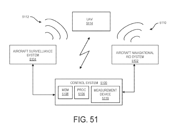
changes, extending flying time. The human's adjustments may be incorrect,
which may extend
flight check time even longer. Thus, existing manual-tuning processes are
cumbersome, potentially
error-prone, and dangerous to execute in hostile environments.
SUMMARY OF THE INVENTION
[0006] According to embodiments of the inventive concepts of the present
disclosure, a
portable instrument landing system (PILS) is described. The PILS includes a
plurality of antenna
radio units, each antenna radio unit configured to set transmission parameters
for an antenna
element. The PILS also includes a glideslope comprising a glideslope non-
imaging antenna array
of antenna elements, each antenna element of the glideslope non-imaging
antenna array being
directly coupled to a respective antenna radio unit of the plurality of
antenna radio units. The
glideslope is configured to communicate, to the respective antenna radio units
directly coupled to
each antenna element of the glideslope non-imaging antenna array, transmission
parameters for
RF signals to be generated by the respective antenna radio units directly
coupled to each antenna
element of the glideslope non-imaging antenna array. The PILS also includes a
localizer
comprising a localizer antenna array of antenna elements, each antenna element
of the localizer
antenna array being directly coupled to a respective antenna radio unit of the
plurality of antenna
radio units. The localizer is configured to communicate, to the respective
antenna radio units
directly coupled to each antenna element of the localizer antenna array,
transmission parameters
2
CA 03161671 2022-05-13
WO 2021/096565 PCT/US2020/037203
for RF signals to be generated by the respective antenna radio units directly
coupled to each
antenna element of the glideslope non-imaging antenna array. The PILS also
includes a control
system configured to configured to communicate, to one of the localizer and
the glideslope, data
to be used by one of the localizer and the glideslope to generate the
transmission parameters for
RF signals to be generated by the plurality of antenna radio units.
[0007] According to embodiments, an antenna radio unit of a portable
instrument landing
system (PILS) is also described. The antenna radio unit comprises transmission
circuity that is
configured to receive a communication comprising transmission parameters for a
radio frequency
(RF) signal to be transmitted using an antenna element directly coupled to the
antenna radio unit.
The transmission circuity is also configured to generate the RF signal using
the transmission
parameters. The transmission circuitry is further configured to transmit the
RF signal using the
antenna element directly coupled to the antenna radio unit.
[0008] According to embodiments, a glideslope of a portable landing system
(PILS) is also
described. The glideslope comprises a non-imaging antenna array, each antenna
element of the
non-imaging antenna array directly coupled to a respective antenna radio unit
of a plurality of
antenna radio units of the PILS. The glideslope also comprises processing
circuity coupled to each
respective antenna radio unit directly coupled to a respective antenna element
of the non-imaging
antenna array. The processing circuitry is configured to receive, from a
control system of the PILS,
data to be used to generate transmission parameters for radio frequency (RF)
signals to be
generated by the plurality of antenna radio units. The processing circuity is
also configured to
generate transmission parameters for radio frequency (RF) signals to be
transmitted by the antenna
elements of the non-imaging antenna array based on the received data. The
processing circuitry is
further configured to communicate the transmission parameters to the antenna
radio units to
generate the RF signals for transmission from the antenna elements of the non-
imaging antenna
array.
[0009] According to embodiments, a localizer of a portable landing system
(PILS) is also
described. The localizer comprises an antenna array, each antenna element of
the antenna array
directly coupled to a respective antenna radio unit of the plurality of
antenna radio units of the
PILS. The localizer also comprises processing circuity coupled to each
respective antenna radio
unit directly coupled to a respective antenna element of the antenna array.
The processing circuity
is configured to receive, from a control system of the PILS, data to be used
to generate transmission
3
CA 03161671 2022-05-13
WO 2021/096565 PCT/US2020/037203
parameters for radio frequency (RF) signals to be generated by each respective
radio unit of the
PILS. The processing circuitry is also configured to generate transmission
parameters for radio
frequency (RF) signals to be transmitted by the antenna elements of the
antenna array based on the
received data. The processing circuity is further configured to communicate
the transmission
parameters to the respective antenna radio units to generate the RF signals
for transmission from
the antenna elements of the antenna array.
[0010] According to embodiments, a method performed by an antenna radio
unit of a portable
instrument landing system (PILS) is described. The method includes receiving a
communication
comprising transmission parameters for a radio frequency (RF) signal to be
transmitted using an
antenna element directly coupled to the antenna radio unit. The method also
includes generating a
radio frequency (RF) signal using the transmission parameters. The method
further includes
transmitting the RF signal using the antenna element directly coupled to the
antenna radio unit.
[0011] According to embodiments, a method performed by a glideslope of a
portable landing
system (PILS) is described. The glideslope comprises a non-imaging antenna
array, each antenna
element of the non-imaging antenna array directly coupled to a respective
antenna radio unit of a
plurality of antenna radio units of the PILS. The method includes receiving,
from a control system
of the PILS, data to be used to generate transmission parameters for radio
frequency (RF) signals
to be generated by each respective radio unit of the PILS. The method also
includes generating
transmission parameters for radio frequency (RF) signals to be transmitted by
the antenna elements
of the non-imaging antenna array based on the received data. The method
further includes
communicating the transmission parameters to the respective antenna radio
units to generate the
RF signals for transmission from the antenna elements of the non-imaging
antenna array.
[0012] According to embodiments, a method performed by a localizer of a
portable landing
system (PILS) is described. The localizer comprising an antenna array, each
antenna element of
the antenna array directly coupled to a respective antenna radio unit of a
plurality of antenna radio
units of the PILS. The method includes receiving, from a control system of the
PILS, data to be
used to generate transmission parameters for radio frequency (RF) signals to
be generated by a
plurality of antenna radio units of the PILS. The method also includes
generating transmission
parameters for radio frequency (RF) signals to be transmitted by the antenna
elements of the
antenna array based on the received data. The method also includes
communicating the
4
CA 03161671 2022-05-13
WO 2021/096565 PCT/US2020/037203
transmission parameters to the respective antenna radio units to generate the
RF signals for
transmission from the antenna elements of the non-imaging antenna array.
[0013] According to some other embodiments, a control system of a portable
landing system
(PILS) is also described. The control system comprises transceiver configured
to communicate
with an unmanned aircraft system (UAS). The control system also comprises a
processor and a
memory, the memory comprising executable instructions that when executed by
the processor
causes the processor to operate to receive, from the UAS using the
transceiver, measurement data
associated with first radio frequency (RF) signals transmitted by one of a
localizer and a glideslope
of the PILS. The memory also comprises executable instructions that when
executed by the
processor causes the processor to operate to generate data to be used by one
of the localizer and
the glideslope to generate transmission parameters to be used by antenna radio
units of the PILS
directly coupled to the respective antenna elements of one of a localizer
antenna array and a
glideslope non-imaging antenna array to generate second RF signals to be
transmitted by the
antenna elements of the one of the localizer antenna array and the glideslope
non-imaging antenna
array. The memory further comprises executable instructions that when executed
by the processor
causes the processor to operate to communicate, to one of the localizer and
the glideslope, the data
to be used by one of the localizer and the glideslope to generate the
transmission parameters.
[0014] According to some other embodiments, a method performed by a control
system of a
portable landing system (PILS) is described. The method includes receiving,
from an unmanned
aircraft system (UAS) using a transceiver of the control system, measurement
data associated with
first radio frequency (RF) signals transmitted by one of a localizer and a
glideslope of the PILS.
The method also includes generating data to be used by one of the localizer
and the glideslope to
generate transmission parameters to be used by antenna radio units of the PILS
directly coupled to
the respective antenna elements of one of a localizer antenna array and a
glideslope non-imaging
antenna array to generate second RF signals to be transmitted by the antenna
elements of the one
of the localizer antenna array and the glideslope non-imaging antenna array.
The method further
includes communicating, to one of the localizer and the glideslope, the data
to be used by one of
the localizer and the glideslope to generate the transmission parameters.
[0015] As described herein, the Portable ILS (PILS) solution includes a
lightweight, low
power Localizer using a Software Defined Radio (SDR) transceiver. SDR' s
provide the dynamic
CA 03161671 2022-05-13
WO 2021/096565 PCT/US2020/037203
flexibility in a small package to allow the performance of traditional antenna
arrays to be realized
through a distributed architecture allowing tuning control of individual
antenna elements.
[0016] The PILS also utilizes an adaptive beam-forming network of ground-
placed antennas
to provide a conventional ILS glide-slope. The glide-slope electronics will
incorporate the
identical, field proven transceiver building blocks utilized for the
Localizer. By eliminating the
traditional glide-slope mast and the complexities associated with set-up,
adjustment, and
calibration ¨ as well as the restrictions on airfield topography ¨ we are able
to introduce a system
that is much faster to deploy, much smaller to transport and suitable for use
in the most challenging
airfield terrain conditions.
[0017] The entire solution will be deployable in less than 2 hours, with 2
personnel. As part
of the design experiment, Thales will design a mechanical packaging of these
field proven
technologies and demonstrate that the solution is capable of being stored on a
single 463L pallet
position. In order to support the 2 hour set-up time, Thales will leverage
research and development
already underway on using drones to calibrate ILS signal-in-space prior to
flight-check. For the
PILS or Small Footprint Precision Approach Landing Capability (SF-PALC)
application, a drone
localization solution for GPS denied environments needs to be developed and
tested. Finally, the
use of the calibration drone will be extended to real-time tuning and
calibrating of the ILS signal-
in-space. Given a fully digital, adaptive design, real-time feedback from the
drone at several down-
range locations and altitudes will enable rapid tuning of the Localizer and
Glide-slope signals-in-
space to eliminate site specific reflections and deployment.
[0018] According to some embodiments, a method performed by a control
system in
communication with one of an aircraft navigational aid system and an aircraft
surveillance system
is described. The method includes obtaining measurement data associated with
radio frequency
(RF) signals transmitted by the one of the aircraft navigational aid system
and the aircraft
surveillance system from an unmanned aerial vehicle (UAV) reporting the
measurement data. The
method also includes determining whether the measurement data indicates the RF
signals are
within a range of values based on a location of the UAV in an airspace
proximate to the one of the
aircraft navigational aid system and the aircraft surveillance system. The
method further includes
controlling the RF signals transmitted by the one of the aircraft navigational
aid system and the
aircraft surveillance system based on the measurement data and the location of
the UAV.
6
CA 03161671 2022-05-13
WO 2021/096565 PCT/US2020/037203
[0019] According to some embodiments, a control system in communication
with one of an
aircraft navigational aid system and an aircraft surveillance system is
described. The control
system comprises a processor and a memory comprising executable instructions
that when
executed by the processor causes the processor to perform operations
comprising obtaining
measurement data associated with radio frequency (RF) signals transmitted by
the one of the
aircraft navigational aid system and the aircraft surveillance system from an
unmanned aerial
vehicle (UAV) reporting the measurement data. The memory also comprises
executable
instructions that when executed by the processor causes the processor to
perform operations
comprising determining whether the measurement data indicates the RF signals
are within a range
of values based on a location of the UAV in an airspace proximate to the one
of the aircraft
navigational aid system and the aircraft surveillance system. The memory
further comprises
executable instructions that when executed by the processor causes the
processor to perform
operations comprising controlling the RF signals transmitted by the one of the
aircraft navigational
aid system and the aircraft surveillance system based on the measurement data
and the location of
the UAV.
[0020] According to some embodiments, a computer program product comprised
on non-
transitory computer readable medium is described. The computer program product
includes
executable instructions that when executed by a processor of a control system
in communication
with one of an aircraft navigational aid system and an aircraft surveillance
system, causes the
control system to perform operations of the various methods described herein.
[0021] Other objects, features and advantages of the present invention will
become apparent
from the following detailed description. It should be understood, however,
that the detailed
description and specific examples, while indicating preferred embodiments of
the invention, are
given by way of illustration only, since various changes and modifications
within the scope and
spirit of the invention will become apparent to one skilled in the art from
this detailed description.
BRIEF DESCRIPTION OF THE DRAWINGS
[0022] The accompanying drawings, which are incorporated into and
constitute a part of this
specification, illustrate one or more example aspects of the invention and,
together with the
detailed description, serve to explain their principles and implementations.
7
CA 03161671 2022-05-13
WO 2021/096565 PCT/US2020/037203
[0023] FIG. 1 is a block diagram illustrating an example portable
instrument landing system
(PILS) in accordance with embodiments of the present disclosure;
[0024] FIG. 2 is a block diagram illustrating an example antenna radio unit
in accordance with
embodiments of the present disclosure;
[0025] FIG. 3 is a flowchart illustrating a method performed by an antenna
radio unit of the
portable instrument landing system (PILS) in accordance with embodiments of
the present
disclosure;
[0026] FIG. 4 is a block diagram illustrating an example localizer of the
PILS in accordance
with embodiments of the present disclosure;
[0027] FIG. 5 is a flowchart illustrating a method performed by a localizer
of a portable
instrument landing system (PILS) in accordance with embodiments of the present
disclosure;
[0028] FIG. 6 is a diagram illustrating an example of a fixed-base, 8-
element installed
localizer array consisting of a row of antenna elements known in the art;
[0029] FIG. 7 is a diagram illustrating an example dual dipole antenna as
an example antenna
element of an antenna array of localizer of the PILS in accordance with
embodiments of the present
disclosure;
[0030] FIG. 8 is a plot chart illustrating an example relative power vs.
azimuth angle for the
course plus sideband (CSB) and sideband only (SB 0) signals radiated by the 8-
element array in
accordance with embodiments of the present disclosure;
[0031] FIG. 9 is a plot chart illustrating an example difference in depth
of modulation (DDM)
over the same range of azimuth angle in accordance with embodiments of the
present disclosure;
[0032] FIG. 10 is a block diagram of an example a glideslope of a portable
landing system
(PILS) in accordance with embodiments of the present disclosure;
[0033] FIG. 11 is a diagram illustrating differences between known imaging
antenna arrays
and an example of a non-imaging antenna array of the PILS in accordance with
embodiments of
the present disclosure;
[0034] FIG. 12 is a diagram illustrating an example LPD antenna elements of
a glideslope non-
imaging array in accordance with embodiments of the present disclosure;
[0035] FIG. 13 is a signal plot illustrating experimental results of a
vertical radiation pattern
of an antenna element of a glideslope of a non-imaging antenna array measured
in a chamber;
8
CA 03161671 2022-05-13
WO 2021/096565 PCT/US2020/037203
[0036] FIG. 14 is a plot chart illustrating an example carrier-plus-
sideband (CSB) and
sideband-only (SBO) patterns for a glide slope system in accordance with
embodiments of the
present disclosure;
[0037] FIG. 15 is a plot chart illustrating an example DDM pattern for a
glide slope system in
accordance with embodiments of the present disclosure;
[0038] FIG. 16 is a plot chart illustrating an example CSB and SBO
radiation pattern of a glide
slope antenna element vertical pattern in accordance with embodiments of the
present disclosure;
[0039] FIG. 17 is a plot chart illustrating an example CSB and SBO
radiation pattern of a two-
element null reference array of a glide slope in accordance with embodiments
of the present
disclosure;
[0040] FIG. 18 is a plot chart illustrating an example DDM pattern of a
four-element horizontal
null reference array of a glide slope in accordance with embodiments of the
present disclosure;
[0041] FIG. 19 is a flow chart illustrating a method performed by a
glideslope of a portable
instrument landing system (PILS) in accordance with embodiments of the present
disclosure;
[0042] FIG. 20 is a block diagram illustrating an example architecture that
performs signal
acquisition, digital signal processing, signal conditioning and alarm
detection in accordance with
embodiments of the present disclosure;
[0043] FIG. 21 is a first view of an example packaging solution of a
localizer of the PILS
system in accordance with embodiments of the present disclosure;
[0044] FIG. 22 is a second view of the example packaging solution of the
localizer of the PILS
system in accordance with embodiments of the present disclosure;
[0045] FIG. 23 is a view of an expansion of the packaged localizer of the
PILS system in
accordance with embodiments of the present disclosure;
[0046] FIG. 24 is a first view of the example packaging solution of a
glideslope of the PILS
system in accordance with embodiments of the present disclosure;
[0047] FIG. 25 is a second view of the example packaging solution of the
glideslope of the
PILS system in accordance with embodiments of the present disclosure;
[0048] FIG. 26 is a block diagram illustrating an example command and
control system (CCS)
of the PILS system in accordance with embodiments of the present disclosure;
[0049] FIG. 27 is a flowchart illustrating a method performed by the
command and control
system of the PILS system in accordance with embodiments of the present
disclosure;
9
CA 03161671 2022-05-13
WO 2021/096565 PCT/US2020/037203
[0050] FIG. 28 is a flowchart illustrating a method of determining whether
parameters of
second RF signals are within a range of values based on obtained measurement
data in accordance
with embodiments of the present disclosure;
[0051] FIG. 29 is a flowchart illustrating a method of communicating
maintenance data to be
used by one of the localizer and the glideslope to generate the maintenance
transmission
parameters to one of a localizer and a glideslope in accordance with
embodiments of the present
disclosure;
[0052] FIG. 30 is a flowchart illustrating a method of determining a
location of a UAS in
airspace proximate to an aircraft runway in accordance with embodiments of the
present
disclosure;
[0053] FIG. 31 is a flowchart illustrating a method of communicating an
instruction to travel
to a different location in the airspace to the UAS in accordance with
embodiments of the present
disclosure;
[0054] FIG. 32 is a block diagram illustrating a first example end-to-end
unmanned calibration
system (E2EUC) in accordance with embodiments of the present disclosure;
[0055] FIG. 33 is a block diagram illustrating a second example end-to-end
unmanned
calibration system (E2EUC) in accordance with embodiments of the present
disclosure;
[0056] FIGs. 34A-34C are block diagrams illustrating a third example end-to-
end unmanned
calibration system (E2EUC) in accordance with embodiments of the present
disclosure;
[0057] FIG. 35 is a block diagram illustrating an example control loop
structure for a closed
loop drone-based tuning of a navigation in accordance with embodiments of the
present disclosure;
[0058] FIG. 36 is a diagram of a top down view of an example approach with
certain reference
points;
[0059] FIG. 37 is a plot diagram of a Difference in Depth of Modulation
(DDM) displacement
sensitivity for a localizer;
[0060] FIG. 38 is a diagram illustrating an example course tolerance for a
localizer in
accordance with embodiments of the present disclosure;
[0061] FIG. 39 is a plot chart illustrating an example relationship between
a localizer course
tolerance and a runway length in accordance with embodiments of the present
disclosure;
[0062] FIG. 40 is a diagram illustrating course sector width for a
localizer in accordance with
embodiments of the present disclosure;
CA 03161671 2022-05-13
WO 2021/096565 PCT/US2020/037203
[0063] FIG. 41 is a plot cart illustrating an example relationship between
a localizer sector
width and a runway length in accordance with embodiments of the present
disclosure;
[0064] FIG. 42 is a diagram illustrating an example glide path
commissioning angle and
tolerance;
[0065] FIG. 43 is a plot chart illustrating an example relationship between
a glide path
tolerance and a glide path angle in accordance with embodiments of the present
disclosure;
[0066] FIG. 44 is a diagram illustrating an example glide path sector
width;
[0067] FIG. 45 is a plot chart illustrating an example relationship between
the glide path sector
width tolerance and a glide path angle in accordance with embodiments of the
present disclosure;
[0068] FIG. 46 is a plot chart illustrating an example relationship between
a height tolerance
and a glide path angle in accordance with embodiments of the present
disclosure;
[0069] FIG. 47 is a plot chart illustrating an example relationship between
an elevation angle
of a drone and fixed range and various heights in accordance with embodiments
of the present
disclosure;
[0070] FIG. 48 is a plot chart illustrating an example relationship between
an elevation angle
to a drone and range to a drone at various drone heights in accordance with
embodiments of the
present disclosure;
[0071] FIG. 49 is a chart illustrating an example drone crossing pattern
for localizer and glide
path measurements in accordance with embodiments of the present disclosure;
[0072] FIG. 50 is a block diagram illustrating an example central control
system in accordance
with embodiments of the present disclosure;
[0073] FIG. 51 is a block diagram illustrating a control system in
communication with an
aircraft navigational system and an aircraft surveillance system in accordance
with embodiments
of the present disclosure;
[0074] FIG. 52 is a flowchart illustrating a method performed by the
control system in
accordance with embodiments of the present disclosure;
[0075] FIG. 53 is a flowchart illustrating a method of determining whether
an actual location
of a UAV is within a predetermined threshold of a desired location within an
airspace in
accordance with embodiments of the present disclosure;
[0076] FIG. 54 is a flowchart illustrating a method of communicating an
instruction to report
measurement data to a UAV in accordance with embodiments of the present
disclosure;
11
CA 03161671 2022-05-13
WO 2021/096565 PCT/US2020/037203
[0077]
FIG. 55 is a flowchart of a method of communicating a second instruction to
adjust an
actual position of the UAV to be within a predetermined threshold to a UAV in
accordance with
embodiments of the present disclosure;
[0078]
FIG. 56 is a flowchart of a method of communicating an instruction to modify
transmission parameters associated with RF signals to one of the aircraft
navigational system and
the aircraft surveillance system in accordance with embodiments of the present
disclosure;
[0079]
FIG. 57 is a flowchart of a method of determining whether updated measurement
data
indicates modified RF signals are within a range of values in accordance with
embodiments of the
present disclosure;
[0080]
FIG. 58 is a flowchart of a method of communicating an instruction to report
updated
measurement data to a UAV in accordance with embodiments of the present
disclosure;
[0081]
FIG. 59 is a flowchart of a method of determining whether updated measurement
data
indicates a modified RF signal transmitted only from an antenna element of an
antenna array is
within a range of values in accordance with embodiments of the present
disclosure; and
[0082]
FIG. 60 is a flowchart of a method of controlling RF signals transmitted by
one of the
aircraft navigational aid system and the aircraft surveillance system based on
second measurement
data and a second location of the UAV within the airspace in accordance with
embodiments of the
present disclosure.
DETAILED DESCRIPTION
[0083]
The presently disclosed subject matter now will be described more fully
hereinafter
with reference to the accompanying Drawings, in which some, but not all
embodiments of the
presently disclosed subject matter are shown. Like numbers refer to like
elements throughout.
The presently disclosed subject matter may be embodied in many different forms
and should not
be construed as limited to the embodiments set forth herein; rather, these
embodiments are
provided so that this disclosure will satisfy applicable legal requirements.
Indeed, many
modifications and other embodiments of the presently disclosed subject matter
set forth herein will
come to mind to one skilled in the art to which the presently disclosed
subject matter pertains
having the benefit of the teachings presented in the foregoing descriptions
and the associated
Drawings. Therefore, it is to be understood that the presently disclosed
subject matter is not to be
12
CA 03161671 2022-05-13
WO 2021/096565 PCT/US2020/037203
limited to the specific embodiments disclosed and that modifications and other
embodiments are
intended to be included within the scope of the appended claims.
[0084] According to embodiments of the inventive concepts of the present
disclosure, a
portable instrument landing system (PILS) is described. The PILS includes a
plurality of antenna
radio units, each antenna radio unit configured to generate a radio frequency
(RF) signal for
transmission by an antenna element directly coupled to the antenna radio unit.
The PILS also
includes a glideslope comprising a glideslope non-imaging antenna array of
antenna elements,
each antenna element of the glideslope non-imaging antenna array being
directly coupled to a
respective antenna radio unit of the plurality of antenna radio units. For
example, FIG. 1 illustrates
an example PILS 100 that includes a plurality of antenna radio units (not
shown), each antenna
radio unit configured to set transmission parameters for an antenna element.
Example
implementations of the antenna radio units (ARUs) are described herein below.
FIG. 1 also
illustrates an example PILS glideslope (GS) 102 comprising a glideslope non-
imaging antenna
array of antenna elements A 1 -A4. Each antenna element A 1 -A4 of FIG. 1 is
directly coupled to a
respective antenna radio unit (not shown) of a plurality of antenna radio
units of PILS 100.
[0085] The glideslope of the PILS is configured to communicate, to the
respective antenna
radio units directly coupled to each antenna element of the glideslope non-
imaging antenna array,
transmission parameters for RF signals to be generated by the respective
antenna radio units
directly coupled to each antenna element of the glideslope non-imaging antenna
array according
to embodiments. For example, GS 102 may be configured to communicate, to the
respective
antenna radio units directly coupled to antenna elements Al-A4, transmission
parameters for RF
signals to be generated by the respective antenna radio units directly coupled
to antenna elements
A 1 -A4.
[0086] According to embodiments, the PILS also includes a localizer
comprising a
localizer antenna array of antenna elements, each antenna element of the
localizer antenna array
being directly coupled to a respective antenna radio unit of the plurality of
antenna radio units.
FIG. 1 illustrates an example PILS localizer 104 comprising a localizer
antenna array (not shown)
of antenna elements, each antenna element of the localizer antenna array being
directly coupled to
a respective antenna radio unit (not shown) of the plurality of antenna radio
units of PILS 100.
Example implementations of the localizer antenna array are described herein
below.
13
CA 03161671 2022-05-13
WO 2021/096565 PCT/US2020/037203
[0087] The PILS also includes a control system configured to communicate,
to one of the
localizer and the glideslope, data to be used by one of the localizer and the
glideslope to generate
the transmission parameters for RF signals to be generated by the plurality of
antenna radio units.
Continuing the example, FIG. 1 illustrates PILS 100 includes PILS Command and
Control System
(CCS) 106 configured to communicate, to one of localizer 104 and glideslope
102, data to be used
by one of localizer 104 and glideslope 102 to generate the transmission
parameters for RF signals
to be generated by the plurality of antenna radio units (not shown) of PILS
100.
[0088] In some embodiments, the transmission parameters comprise one or
more of a
power, modulation indexes, and phase of an RF signal for transmission by an
antenna element.
According to some embodiments, the glideslope non-imaging antenna array is
configured to be
arranged in parallel to an aircraft runway. For example, FIG. 1 illustrates
antenna elements Al-A4
arranged in parallel to an aircraft runway. In some embodiments, the localizer
antenna array is
configured to one collapse and expand. Examples of the localizer antenna array
are discussed in
further detail below in reference to FIG. 23. In some embodiments, the
plurality of antenna radio
units, glideslope, glideslope non-imagining antenna array, localizer,
localizer antenna array, and
control system are configured to be transported on a cargo pallet prior to
deployment. Example
configurations of the plurality of antenna radio units, glideslope, glideslope
non-imagining antenna
array, localizer, localizer antenna array, and control system on a cargo
pallet prior to deployment
are discussed in further detail below with reference to FIGs. 21-22 and 24-25.
[0089] The Portable Instrument Landing System solution is made possible
through
advancement in electronics technology and innovative thinking from a cross-
section of Thales
engineers from several disciplines and backgrounds. The solution provides a
conventional ILS
signal in space for reception of all presently equipped aircraft but in a
greatly reduced package
over prior conventional or deployable ILS solutions.
[0090] As shown in Figure 1, the PILS 100 solution is comprised of
Localizer 104 and
Glide Slope (GS) 102 (also known as Glide Path) subsystems, augmented with a
Flight Check
Radio (FCR) 108 solution and supplied with an automated, Tuning Drone (TD) 110
that is
managed by a Command and Control Subsystem (CCS) 106. The solution provides
for full
deployment at two locations (Loc 104 & GS 102) to expedite setup by
collocating the FCR 108
and CCS 106 functions at the GP 102 location. In an alternative
implementation, the CCS function
includes the overall status of the ILS operation, it is also designed to be
separated from the GP 102
14
CA 03161671 2022-05-13
WO 2021/096565 PCT/US2020/037203
if base operations are better supported by being collocated with other
airfield equipment and
personnel. For example, FIG. 1 illustrates a CCS 112 configured to be remotely
located from the
GP 102.
[0091] One key advancement in technology that makes such solution
feasible today is the
introduction of software defined radio (SDR) transmitters/receivers, or
transceivers. SDR's
provide the dynamic flexibility in a small package to allow the performance of
some traditional
antenna arrays and inventive antenna arrays described herein to be realized
through a distributed
architecture allowing tuning control of individual antenna elements and
monitoring of performance
through an Antenna Radio Unit (ARU).
[0092] According to embodiments, an antenna radio unit of a portable
instrument landing
system (PILS) is also described. For example, FIG. 2 illustrates an example
antenna radio unit
(ARU) 200 as described above with regards to FIG. 1. The antenna radio unit
comprises
transmission circuity that is configured to receive a communication comprising
transmission
parameters for a radio frequency (RF) signal to be transmitted using an
antenna element directly
coupled to the antenna radio unit. For example, ARU 200 of FIG. 2 is
configured to receive, from
one of GS 102 or LOC 104 of FIG. 1 via TX Data Port 208, a communication
comprising
transmission parameters for a radio frequency (RF) signal to be transmitted
using an antenna
element directly coupled to the antenna radio unit, such as one of antenna
elements Al-A4
illustrated in FIG. 1.
[0093] The antenna radio unit 200 may be directly coupled to an antenna
element via two
RF cables ¨ one for transmission of the RF signal via the antenna element and
the other to receive
the transmitted signal for monitoring. No other signal processing components
intervene between
the antenna radio unit 200 and the antenna element. The ARU 200 may be
comprised within a
housing or package that is configured to be attached to a structure supporting
the antenna element
or the antenna element structure.
[0094] In one embodiment, the antenna radio unit may receive a
communication
comprising transmission parameters for a RF signal to be transmitted from an
antenna element of
the glideslope non-imaging antenna array directly coupled to the antenna radio
unit. For example,
ARU 200 may receive transmission parameters for a RF signal to be transmitted
using one of
antenna elements A1-A4 illustrated in FIG. 1 directly coupled to ARU 200. In
another
embodiment, the antenna radio unit may receive a communication comprising
transmission
CA 03161671 2022-05-13
WO 2021/096565 PCT/US2020/037203
parameters for a RF signal to be transmitted from an antenna element of the
localizer antenna array
directly coupled to the antenna radio unit. For example, ARU 200 may receive
transmission
parameters for a RF signal to be transmitted using one of antenna elements of
a localizer antenna
array of localizer 104 illustrated in FIG. 1 directly coupled to ARU 200.
[0095] According to some embodiments, the transmission circuity is also
configured to
generate the RF signal using the transmission parameters. For example, the TX
circuitry 202 may
be configured generate the RF signal using the transmission parameters
communicated by one of
GS 102 and LOC 104. The transmission circuitry is further configured to
transmit the RF signal
using the antenna element directly coupled to the antenna radio unit in
accordance with some
embodiments. Continuing the example, TX circuitry 202 may be further
configured to transmit the
RF signal towards an RF feed port 204 of one of an antenna element directly
coupled to ARU 200,
such as one of antenna elements A1-A4.
[0096] According to embodiments, the antenna radio unit further comprises
reception
circuity configured to receive the RF signal transmitted by the antenna
element. For example, FIG.
2 illustrates ARU 200 comprises RX circuitry 220 configured to receive a RF
signal from a monitor
port 206 of an antenna element directly coupled to ARU 200, such as one of
antenna elements Al-
A4. The reception circuity is also configured to generate measurement data
based on the received
RF signal according to embodiments. Continuing the example, RX circuitry 220
is also configured
generate measurement data based on the received RF signal. The reception
circuity is further
configured to communicate the measurement data to one of a localizer and a
glideslope of the
PILS. For example, FIG. 2 illustrates RX circuitry 220 is configured to
communicate the
measurement data to one of GS 102 and LOC 104 via a RX Data Port 210 of ARU
200.
[0097] FIG. 3 illustrates a method performed by an antenna radio unit of
a portable
instrument landing system (PILS) according to embodiments. FIG. 3 illustrates
the method
includes receiving 300 a communication comprising transmission parameters for
a radio frequency
(RF) signal to be transmitted using an antenna element directly coupled to the
antenna radio unit.
FIG. 3 also illustrates the method also includes generating 302 a radio
frequency (RF) signal using
the transmission parameters. The method further includes transmitting 303 the
RF signal using the
antenna element directly coupled to the antenna radio unit as illustrated in
FIG. 3. The method
may also include receiving the transmission parameters from one of a localizer
and a glideslope of
the PILS. The method may also include receiving the RF signal transmitted by
the antenna element,
16
CA 03161671 2022-05-13
WO 2021/096565 PCT/US2020/037203
generating measurement data based on the received RF signal, and communicating
the
measurement data to one of a localizer and a glideslope of the PILS.
[0098] The incorporation and application of the ARU' s 200 into the
Localizer 104 and
Glide Slope 102 subsystems is described herein below. Monitor & control,
solution power scheme,
remote maintenance and the approach to satisfying the requirements for flight
check radio are also
described herein below.
[0099] The Antenna Radio Unit 200 is in charge to generate and to measure
the radio
frequency signal irradiated by its associated antenna. All the ARUs in the
PILS system 100 are
identical in HW/FW, but each ARU 200 will produce a different RF signal
according to the
configuration set by the Digital Processing Unit (DPU) 404 (Localizer) or 1004
(Glide Slope)
(mainly power, phase and modulation indexes). The ARU 200 is a small box with
two mono-
directional RF ports 204, 206 (to the antenna "feed" 204 and from the antenna
"mon" 206) and
two bi-directional DATA ports 208, 210 (to/from the DPU, one for the RX
section (210), the other
for the TX section (208)). The data cables of each ARU converge to the
dedicated ports of the
DPU 404 (Localizer) / 1004 (GP), which manages all the ARUs of the localizer
of glideslope,
respectively. Figure 2 illustrates an example functional block diagram of one
ARU 200. FIG. 2
also illustrates an example upper TX section comprising TX circuity 202 that
comprises:
= The assembler/disassembler block 212 configured to:
¨ disassemble from the TX DATA PORT the synchronization pulses and the
configuration data.
¨ assemble to the TX DATA PORT the synchronization returns and the
messages.
= The sync block 214 that manages the sync pulses produced by DPU 404 or
DPU
1004
= The TX generation block 216 may comprise an FPGA which generates the
baseband RF signal, based on the configuration data (power, phase, modulation
indexes...) set by DPU 404 or DPU 1004.
= The TX RF chain block 218 that may comprise a RF D/A converter followed
by a
Power Amplifier and a control loop.
[00100] In the lower RX section comprising RX circuity 220 that comprises:
= The RF chain block 222 that may comprise a RF A/D converter.
= The RX measurement block 224 may comprise an FPGA which analyses the
baseband RF signal and returns the estimated values (expected to be the same
as
the TX configuration data) to DPU 404 or DPU 1004.
17
CA 03161671 2022-05-13
WO 2021/096565 PCT/US2020/037203
= The RF sync block 226 manages the sync pulses produced by the Central
Unit
106.
= The assembler/disassembler block 228 configured to:
¨ disassemble from the RX DATA PORT 210 the synchronization pulses and
the messages.
¨ assemble to the RX DATA PORT 210 the synchronization returns and the
measurement data.
[00101] DC Power for the entire ARU may be provided from the DPU 404 or
1004 via the
ARU' s RX Data Port 210. The power solution includes also the prioritization
and sequencing logic
to automatically switch from primary power to secondary power (e.g. generator)
upon loss of
primary power. The solution also included the capability to automatically
switch back to primary
power once restored. In addition to primary and secondary AC power inputs, the
PILS power
solution will provide battery backup so that all navigation and communications
components
remain operational during power transitions or complete loss of external
power. Battery backup
will be sized to provide enough of operation from a full charge which is
consistent with fixed
navaid solutions. For example, processing and power management circuity 230
illustrated in FIG.
2 may be configured to automatically switch from primary power to secondary
power (e.g.
generator) upon loss of primary power and switch back to primary power once
restored.
[00102] As regards to some technological aspects, the following
considerations (risk and
opportunities) can apply:
[00103] Since the RF signal delivered to each antenna can be individually
programmed by
its associated ARU 200, the PILS system 100 has the opportunity to produce a
signal-in-space
with more flexibility than the existing ILS system, in which the array
patterns are fixed. (Also the
alignment procedure can be totally or partially based on software instead of
cutting the RF antenna
cables).
[00104] Since each ARU 200 is able to individually measure the RF signal
irradiated by its
associated antenna, the PILS system 100 has the opportunity to estimate the
signal-in-space with
more flexibility than the existing ILS system, in which the estimation is
performed at fixed angles.
[00105] The RF generation and measurement in the ARU 200 may be performed
utilizing
Software Defined Radio technology. The signal produced by each ARU 200 for the
PILS (LOC
or GP signals), with the single frequency assumption, is:
s(t) = Vo * 1 / + in, *cos ( 27/-fit + pi)] * cos / 2n-fo *t +
coo]
18
CA 03161671 2022-05-13
WO 2021/096565 PCT/US2020/037203
[00106] In essence, a carrier at frequency fo (about 110MHz for LOC and
330MHz for GP),
modulated by a sum of low frequency signals f, (90Hz, 150Hz and 1020Hz), with
different
modulation indexes, phases and power. Since this signal is very similar to a
Doppler-VOR
(DVOR) signal, it was quite easy to implement during experiments utilizing a
basic 4 element
Localizer and re-programming a RF board formerly designed for the DVOR (but
with the
simplification to drive the four antennas with the same reference clock). This
experiment has
demonstrated that the ILS signal can be easily generated with the SDR
technology. The monitoring
function in the PILS 100 system is distributed among all the ARUs of PILS 100
and the Central
Unit 106.
[00107] According embodiments, a localizer of a portable instrument
landing system (PILS)
is also described. FIG. 4 illustrates an example localizer 400 of PILS 100.
The localizer comprises
an antenna array, each antenna element of the antenna array directly coupled
to a respective
antenna radio unit of the plurality of antenna radio units of the PILS
according to embodiments.
Continuing the example, FIG. 4 illustrates localizer 400 comprises an antenna
array 402, each
antenna element 402L. .402R of antenna array 402 are directly coupled to a
respective ARUs
4L. 4R of the PILS 100. The localizer also comprises processing circuity
coupled to each
respective antenna radio unit directly coupled to a respective antenna element
of the antenna array.
For example, FIG. 4 illustrates localizer 400 comprises a digital processing
unit 404 coupled to
ARUs 402L. .402R directly coupled to respective antenna elements 402L. .402R
of antenna array
402.
[00108] The processing circuity is configured to receive, from a control
system of the PILS,
data to be used to generate transmission parameters for radio frequency (RF)
signals to be
generated by each respective radio unit of the PILS according to embodiments.
Continuing the
previous example, FIG. 4 illustrates digital processing unit 404 may be
configured to receive, from
CCS 106 of the PILS 100, data to be used to generate transmission parameters
for radio frequency
(RF) signals to be generated by ARU 4L-4R . The processing circuitry is also
configured to
generate transmission parameters for radio frequency (RF) signals to be
transmitted by the antenna
elements of the antenna array based on the received data according to
embodiments. For example,
DPU 404 illustrated in FIG. 4 may be configured to generate transmission
parameters for radio
frequency (RF) signals to be transmitted by the antenna elements 402L-402R of
antenna array 402
19
CA 03161671 2022-05-13
WO 2021/096565 PCT/US2020/037203
based on the received data. According to embodiments, the processing circuity
is further
configured to communicate the transmission parameters to the respective
antenna radio units to
generate the RF signals for transmission from the antenna elements of the
antenna array. FIG. 4
further illustrates example DPU 404 may be configured to communicate the
transmission
parameters to ARU 4L and/or ARU 4R units to generate the RF signals for
transmission from the
antenna elements 402L and/or 402R of the antenna array.
[00109] The PILS Localizer Subsystem 100 design brings a field-proven, 8-
element
localizer antenna array distribution in a quickly deployable, compact package.
This includes a
compact antenna design over conventional, fixed base ILS localizer solutions
with each antenna
driven by a dedicated Antenna Radio Unit 200. As shown in FIG. 4, the
Localizer Subsystem 400
includes circuitry and/or software modules that provide capabilities required
for:
= power conversion/battery backup (e.g., Input Power Selector 422, Power
Conversion Circuity/Module 406, Battery Backup Circuity/Module 408),
= signal generation and radiation (e.g., Data Multiplexor 410, TX Sync
Pulse
Generator 412, Embedded Maintenance CPU 424),
= monitoring of signal performance and associated control action (e.g.,
PILS
Monitor & Control Circuity/Module 414, RX Sync Pulse Generator 416,
Embedded Maintenance CPU 424) and
= remote interface for antenna tuning and status reporting to Air Traffic
Control
personnel or remote system maintainer (e.g., Wireless Data Radio 418 and
Antenna 420).
[00110] The data interface between the functions contained in the Digital
Processing Unit
(DPU) 404 include:
= Dedicated data communication to each ARU 4L. .4R for configuring and
adjusting transmitter parameters on a per-antenna basis,
= Synchronization signal for maintaining phase coherence of the RF carrier
of the
individual elements,
= Dedicated data communication from each ARU 4L. .4R for providing monitor
data sets for constructing the signal-in-space for measure of system
performance,
= Independent synchronization signal for alignment of individual monitor
measurements and
= DC power source that is removed by the control circuits if alarm
condition is
detected. Alternatively, or in combination, this function can be performed by
power conversion circuity 406.
CA 03161671 2022-05-13
WO 2021/096565 PCT/US2020/037203
[00111] FIG. 5 illustrates a method performed by a localizer of a portable
instrument
landing system (PILS) according to embodiments. The method includes receiving
500, data to be
used to generate transmission parameters for radio frequency (RF) signals to
be generated by a
plurality of antenna radio units of the PILS. The method also includes
generating 502 transmission
parameters for radio frequency (RF) signals to be transmitted by the antenna
elements of the
antenna array based on the received data. The method also includes
communicating 504 the
transmission parameters to the respective antenna radio units to generate the
RF signals for
transmission from the antenna elements of the non-imaging antenna array.
[00112] The proposed localizer antenna component is a phased array that,
in conjunction
with its associated transmitters, radiates a signal in space that complies
with all ICAO Annex
requirements for ILS localizer systems. The localizer antenna array is
typically the physically
largest component of an ILS. In contrast to traditional localizer antenna
arrays, the PILS localizer
array is designed to optimize the tradeoffs between performance and packaging
size. FIG. 6
illustrates a fixed-base, 8-element installed localizer array consisting of a
row of antenna elements
sited a few hundred feet beyond the stop end of the runway. The localizer
antenna elements shown
in FIG. 6 are log periodic dipoles (LPD) which provide good directivity and
front-to-back ratio.
[00113] A critical parameter affecting localizer performance is the array
aperture, i.e. the
total width of the array. The angular width of the transmitted beam is
inversely proportional to the
aperture size. The wider the beam, the greater potential there is for
reflections from structures or
large aircraft near the runway to interfere with the direct signal-in-space
and distort it, introducing
bends into the approach course. Localizer antenna arrays may include 8, 14,
20, or 32 elements,
with apertures ranging from 51 ft for an 8-element array up to 246 ft for a 32-
element array.
However, it should be understood that the above different number of elements
and spacing may
be utilized. For example, different antenna elements and spacing might be
applied to shape the
antenna radio diagram according to specific needs.
[00114] The localizer antenna array of the PILS 100 may be configured to
utilize an 8-
element single frequency localizer antenna array with a new element design in
place of the LPDs
described above. The LPDs described above are typically large and heavy.
According to some
embodiments, the antenna elements of the localizer antenna array includes a
dual dipole antenna.
For example, FIG. 7 illustrates an example dual dipole antenna as an antenna
element of an antenna
array of localizer 400 described above.
21
CA 03161671 2022-05-13
WO 2021/096565 PCT/US2020/037203
[00115] The two dipoles are fed in quadrature. The essential
characteristics of this antenna
may comprise a gain of 4.9 dBi, a front-to-back ratio of 15.3 dB, and a half-
power beam width of
76 . The dual dipole antenna has slightly less directivity than the LPD
described above, which has
negligible effect on the localizer array pattern. The virtue of the dual
dipole antenna is its small
size and weight and ability to be packaged compactly. FIG. 8 shows relative
power vs. azimuth
angle for the course plus sideband (CSB) and sideband only (SBO) signals
radiated by the 8-
element array. FIG. 8 illustrates a theoretical pattern generated by a
computer model with course
width (a measure of displacement sensitivity) set to 4.5 . FIG. 9 shows
difference in depth of
modulation (DDM) over the same range of azimuth angle. DDM is measured by the
aircraft ILS
avionics to determine the aircraft angular offset from the extended runway
centerline.
[00116] According to embodiments, a glideslope of a portable landing
system (PILS) is also
described. For example, FIG. 10 illustrates an example glideslope 1000 of PILS
100. The
glideslope comprises a non-imaging antenna array, each antenna element of the
non-imaging
antenna array directly coupled to a respective antenna radio unit of a
plurality of antenna radio
units of the PILS. For example, FIG. 10 illustrates glideslope 1000 comprises
a non-imaging
antenna array 1002, each antenna element 1002L...1002R of antenna array 1002
are directly
coupled to a respective ARUs GP1...GP4 of the PILS 100. The glideslope also
comprises
processing circuity coupled to each respective antenna radio unit directly
coupled to a respective
antenna element of the non-imaging antenna array. Continuing the example, FIG.
10 also
illustrates glideslope 1000 comprises a digital processing unit (DPU) 1004
coupled to each
respective ARUs GP 1 ...GP4 directly coupled to a respective antenna elements
1002L...1002R of
the non-imaging antenna array 1002. It should be noted that the number of
antenna elements
illustrated are provided as an example and that the number different antenna
elements and spacing
may be utilized to apply shape of antenna radiation diagram according to
specific needs.
[00117] The processing circuitry is configured to receive, from a control
system of the PILS,
data to be used to generate transmission parameters for radio frequency (RF)
signals to be
generated by the plurality of antenna radio units according to embodiments.
Continuing the
previous example, FIG. 10 illustrates DPU 1004 may be configured to receive,
from CCS 106 of
the PILS 100, data to be used to generate transmission parameters for radio
frequency (RF) signals
to be generated by ARUs GP1...GP4. The processing circuitry is further
configured to
communicate the transmission parameters to the antenna radio units to generate
the RF signals for
22
CA 03161671 2022-05-13
WO 2021/096565 PCT/US2020/037203
transmission from the antenna elements of the non-imaging antenna array . For
example, FIG. 10
further illustrates example DPU 1004 may be configured to communicate the
transmission
parameters to antenna radio units such as ARUs GP1...GP4 to generate the RF
signals for
transmission from antenna elements 1002L...1002R of the non-imaging antenna
array 1002.
[00118] The PILS Glide Slope Subsystem 1000 illustrated in FIG. 10 uses
similar building
blocks as the Localizer Subsystem 400 illustrated in FIG. 4. Since the design
comprises digital
circuitry up to the point where the ARU provides the RF signal to its
dedicated antenna there are
no radio frequency specific components in the remainder of the design. The
same power
management approach, DPU and Wireless Data Radio perform similar functions as
described
above with regards to Localizer 400. Since the GP equipment 1000 is offset
from the runway (see
FIG. 1), the FCR function utilizing the Flight Check Radio 1024 and FCR
Antenna 1026 is
collocated with the GP 1000 for power and data interface.
[00119] Designing a PILS glide slope antenna array that meets the
packaging and
installation time requirements for a PILS is more challenging than for a
localizer array. A typical
glide slope antenna array consists of two or three antennas mounted on a
vertical tower. The tower
can be up to 40 ft tall, depending on slope elevation angle. Most known glide
slope arrays are
imaging systems: they achieve a proper glide slope signal in space by
combining the direct
radiation with the radiation reflected from the ground. A two-element glide
slope imaging system
can be viewed as two upper elements, on the tower, and two mirror image
elements, underground.
Such a system requires an expanse of ground several hundred feet in front of
the tower that is flat
and obstruction free in order to function properly.
[00120] For the PILS application, a tower would be prohibitively large and
many SF-PALC
sites will not likely have terrain suitable for an imaging system. In contrast
to known glide slope
imaging systems, the PILS 100 comprises a non-imaging antenna array that is
positioned
horizontally a few feet above the ground. FIG. 11 illustrates the differences
between known
imaging antenna arrays 1100 and the PILS non-imaging antenna array 1102. An
analysis of the
inventive design process from the standard array 1100 to the inventive PILS
non-imaging antenna
array 1102 is described below.
[00121] Consider a standard Null Reference Glide Slope Antenna Array 1100,
as shown in
Frame A of FIG. 11. The direct signals radiated from antennas a and b combine
with the reflected
signals appearing to be radiated by the image antennas c and d to produce the
glide slope signal-
23
CA 03161671 2022-05-13
WO 2021/096565 PCT/US2020/037203
in-space. The usual glide slope elevation angle is 3 , which is determined by
the amplitudes and
phases of the radiated signals as well as the spacing between antennas. An
aircraft below glide
slope will see a fly-up signal and an aircraft above the slope will see a fly-
down signal.
[00122] Now imagine rotating the tower 90 onto its back and replacing the
image antennas
with real ones (Frame B of FIG. 11). The glide slope angle will have rotated
from 3 above the
horizon to 3 off zenith, in the direction away from the runway threshold.
[00123] In Frame C of FIG. lithe phases of the individual antenna elements
are adjusted
to steer the beam an additional 84 counterclockwise, as viewed in FIG. 11, so
that it is again 3
above the horizon, albeit in the opposite direction. At this point Frame C
maintains the
proportionality in element spacing, so that an aircraft on the glide slope
sees the same spacing
between antennas that it would see from the glide slope to a standard Null
Reference array on a
vertical tower. Assuming a 3 glide slope angle this increases the aperture
from 57 feet to 542 feet.
[00124] In Frame D of FIG. lithe array is rotated horizontally 180 to
point the glide slope
in the proper direction. It is also necessary to swap the 90 Hz and 150 Hz
modulation signals to
restore the proper fly-up/fly-down directions. This implementation is a fairly
radical departure
from the standard glide slope antenna design illustrated in Frame A. What
makes it feasible is the
availability of software-defined transmitters that can drive the antenna
elements with signals
having highly accurate amplitudes and phases that can be easily and precisely
adjusted during the
tuning process.
[00125] The current selection for the glide slope non-imaging array
antenna elements is a
log-periodic dipole (LPD) at 330MHz. A 330MHz quarter-wavelength dipole is
also seen as a
viable option for this application. In both options, the small LPDs (by virtue
of operating in the
UHF glide slope frequency band), are considerably more compact than a typical
glide slope
antenna used with an imaging system. FIG. 12 illustrates example LPD antenna
elements of
glideslope non-imaging array. In an alternative embodiment, the non-imaging
array antenna
elements may comprise Vivaldi type of antenna element.
[00126] FIG. 13 shows the vertical radiation pattern of an AAN 104
measured in a chamber
at azimuth angles of 0, 5 and 15 . Preliminary computer modeling of the
horizontal array
derived from the standard Null Reference has been performed with promising
results. FIG. 14
shows the theoretical carrier-plus-sideband (CSB) and sideband-only (SBO)
patterns for 3 glide
slope system. The plot covers the azimuth angle range specified in ICAO Annex
10 as 0.450 to
24
CA 03161671 2022-05-13
WO 2021/096565 PCT/US2020/037203
1.750, or 1.35 to 5.25 . This simulation assumes the AAN 104 vertical
radiation pattern and does
not include effects of reflection from the ground. FIG. 15 shows the DDM
pattern. The plot is
linear and symmetrical about the 0 DDM point and complies with Annex 10
displacement
sensitivity requirements.
[00127] The plots described above are idealized in the sense that the
effect of reflections on
the signal in space have not been accounted for. Any signals that are
reflected from the ground can
interfere with the direct signal. The glide slope signal is horizontally
polarized, which means it
undergoes a 180 phase shift when reflected. The reflected wave will interfere
constructively or
destructively with the direct wave as a function of elevation angle and
antenna height.
[00128] FIG. 16 shows a CSB and SBO radiation pattern generated by a
computer model
that includes reflections from the ground. The simulation assumes smooth and
level ground which
magnifies the reflection effects somewhat compared to what would be expected
for a real system.
[00129] Note that reflections cause a reduction in signal power at
elevation angles below
3 . This occurs because at very low elevation angles the difference in slope
length from the antenna
to the aircraft between the direct and reflected waves is small. Combined with
the 180 phase shift
of the reflected wave this results in non-negligible destructive interference.
[00130] FIG. 17 shows the same CSB and SBO radiation patterns for a
standard Null
Reference glide slope array on a tower. Note that for both the standard and
modified array CSB
and SBO radiated power are reduced at low elevation angles, with the effect
somewhat more
pronounced for the modified array. This is to be expected because the modified
array antennas are
mounted closer to the ground than those of the standard array.
[00131] FIG. 18 shows DDM for the modified array with reflection effects
included. Note
that the DDM pattern is identical to the one without reflection effects. For a
Null Reference array
CSB and SBO are each fed to a single pair of antenna elements. Therefore,
under the assumption
of smooth and level ground the phase shift caused by interference will be the
same for each antenna
in the pair with no net effect on DDM. For a real system slightly different
phase shifts could occur
for each antenna in a pair, resulting in a slight shift in glide slope angle
which would be corrected
by phase adjustments during the tuning process.
[00132] FIG. 19 illustrates a method performed by a glideslope of a
portable instrument
landing system (PILS) according to embodiments. The method includes receiving
1900, from a
control system of the PILS, data to be used to generate transmission
parameters for radio frequency
CA 03161671 2022-05-13
WO 2021/096565 PCT/US2020/037203
(RF) signals to be generated by each respective radio unit of the PILS. The
method also includes
generating 1902 transmission parameters for radio frequency (RF) signals to be
transmitted by the
antenna elements of the non-imaging antenna array based on the received data.
The method further
includes communicating 1904 the transmission parameters to the respective
antenna radio units to
generate the RF signals for transmission from the antenna elements of the non-
imaging antenna
array.
[00133] FIG. 20 illustrates monitor architecture of a PILS Monitor and
Control system 414
(localizer) / 1014 (GP) of the PILS described herein that performs signal
acquisition, digital signal
processing, signal conditioning and alarm detection. The PILS Monitor
architecture illustrated in
FIG. 20 performs antenna signal multiplexing, signal conditioning and alarm
detection for up to
ten low-rate ARU RX channels utilizing the antenna signal conditioning and
protection circuitry
2118, antenna signal multi-plexing circuity 2120, processors 2102 and 2104,
and communication
interfaces 2110- 2116. Local power supplies and voltage protection circuity
2122 provides DC
power and DC voltage signals to portions of the DPU and ultimately also the
antenna radio units,
as needed. Voltage protection circuitry 2122 also provides voltage protection
from power surges
and the like. Clock oscillator and generation circuitry 2124 produces the
clock signal which is used
to keep the DPU and the ARUs in proper synchronization. The PILS Monitor
architecture
illustrated in FIG. 20 requires significantly less microprocessor resources in
comparison to known
DVOR Monitor architecture that can signal condition the low-rate ARU RX signal
information.
The known DVOR data acquisition, digital signal processing and signal
conditioning functionality
acquires 8 channels of RF information at 240 ksps, performs multiple levels of
digital signal
processing before recovering the signal information. In contrast, the PILS
Monitor architecture
illustrated in FIG. 20 only acquires 10 channels of low-rate ARU Signal
Information. The Monitor
function of the PILS Monitor architecture of FIG. 20 is described below.
[00134] Signals 2100 arrive from the antennae's ARU units and are
conditioned by circuity
blocks 2118, multiplexed for processing by antenna signal multi-plexing
circuity 2120, and
distributed to two processors 2102 and 2104 which analyze the signal data and
determine if the
Signal in Space is within specification. The processors also communicate with
the Embedded
Maintenance CPU 2106 via communication interfaces 2112 and 2116. EM CPU 2106
(same as
EM CPU 424 or EM CPU 1026 of FIGs 4 and 10 respectively) is configured to
provide flight
check radio communication and auto-calibration, as well as performance and
maintenance related
26
CA 03161671 2022-05-13
WO 2021/096565 PCT/US2020/037203
information to Tower Control and Maintenance Personnel. The processors 2102
and 2104 also
provide shutdown commands via communication interfaces 2110 and 2114
respectively to the
power control system 2108 (may comprise power conversion circuitry 404 or 1006
of FIGs 4 and
respectively) to remove the signal in space when the signal is detected as out
of specification.
The Monitor function includes Built-In-Test capability, temperature
monitoring, and power
protections circuits. The power shutdown provides failsafe shutdown decision
and interfacing with
the ARU power systems.
[00135] In accordance with embodiments, the plurality of antenna radio
units, glideslope,
glideslope non-imagining antenna array, localizer, localizer antenna array,
and control system are
configured to be transported on a cargo pallet prior to deployment. For
example, the Portable ILS
solution described herein is designed to be compliant with the single 463L
pallet objective while
including all equipment required to setup, tune and operate the system. FIGs.
21 and 22 illustrate
different views of an example packaging solution. FIGS. 21-22 illustrate
different views of two
individual, fork liftable skids for transport to the fielded location from the
air of land drop-off
point.
[00136] The Localizer skid contains:
= Folded localizer array with pre-installed and cabled antenna (with ARU)
and
single obstruction light at each end.
= MEP-015A 1.5KVA Generator, prewired into power selection control.
= Battery backup
= "PILS Control Box" that includes:
o Input power selection logic
o PILS electronics (Monitor & Control, Maintenance Computer...)
o Wireless Data Radio
= WDR antenna and associated mast
= Anchor stowage
= Installation tools
= Spooled AC cable for driving anchors
[00137] The Glide Slope skid contains:
= Four GP Elements in protective case with ARU
= Four Tripods for GP element installation
= Cable spools
= MEP-015A 1.5KVA Generator, prewired into power selection control.
27
CA 03161671 2022-05-13
WO 2021/096565 PCT/US2020/037203
= Battery backup
= "PILS Control Box" that includes:
= Input power selection logic
= PILS electronics (Monitor & Control, Maintenance Computer...)
= Wireless Data Radio
= Flight Check Radio
= WDR antenna and associated mast
= FCR antenna and associated mast
= Anchor stowage
= Installation tools
= Spooled AC cable for driving anchors
= Command and Control Subsystem:
= Ruggedized Laptop
= Drone with payload
= Drone control radio.
= Qty 2, Two-way radio set
[00138] The purpose of this concept design activity was to ensure that the
defined
components of the system could be packaged in the defined space. The complete
PILS packaging
solution is designed as two skids of equipment that are separated at the drop-
off point and moved
to their respective Localizer and Glide Slope locations. Although the solution
is shown to utilize a
forklift, the solution could also be equipped with wheels and extractable tow
bar in an alternative
embodiment.
[00139] According to some embodiments, the localizer antenna array is
configured to one
of collapse and expand. As illustrated in FIG. 23, the Localizer deployment is
straight forward and
easily accomplished by two trained personnel given that it involves a minimal
set of tasks,
including:
= Unfolding each half of the array until fully extended
= Expanding the back support of each frame section
= Lowering of height adjustable frame supports (provided to accommodate
uneven
ground)
28
CA 03161671 2022-05-13
WO 2021/096565 PCT/US2020/037203
= Anchoring of support of the support feet using augur-style anchors
ideally suited
for course-grained and fine-grained soil conditions
= Raising and locking of reach localizer antenna
= Raising and fastening of the directional WDR antenna and align in the
direction of
the Glideslope subsystem location
= Connection of any available shore power (but not required)
= Powering of the Localizer subsystem through use of charged batteries for
generator.
[00140] With the minimal set of tasks and use of provided impact driver to
expedite
installation of the anchors, the Localizer Subsystem with the packaging
described above may be
installed and ready for tuning in 30 to 45 minutes by a properly trained crew.
[00141] FIGs. 24-25 illustrate two different views of the packed
configuration of the Glide
Slope and Command and Control Subsystems as staged for deployment. While the
actual
equipment shown (e.g. tripods) will be specifically designed to match the
program needs for
ground fastening (using auger style anchors as with Localizer) and payload,
anticipated size has
been used to ensure that the equipment can be stowed in the space allotted.
[00142] Deployment of the GP Antenna will utilize an installation aid that
allows for a
straight line to be established to align the four antenna with measurement
marks to establish correct
position parallel to an aircraft runway. Tripods will then be anchored, and
antenna installed using
a quick connect mounting shoe before being cabled and raised to its 2.5-meter
desired height.
[00143] Once all four antenna are installed and cabled back to the GP
Digital Processing
Unit (e.g., DPU 1004 of FIG. 10), power is applied using battery power, on-
board generator or
shore power if available. As with the Localizer, installation of the GP
antenna and cabling may
be accomplished and ready for tuning in 30-45 minutes by properly trained
personnel.
[00144] The PILS solution strives to minimize installation time as
described above. As
such, tear-down and repack is minimized by:
= Use of the auger style anchors which are quickly removed using the
supplied impact
wrench
= Cables spools with cranking mechanism to quickly re-spool cables on their
assigned
drums
= Defined customized stowage locations for each piece of equipment that has
to be
stowed.
29
CA 03161671 2022-05-13
WO 2021/096565 PCT/US2020/037203
= Minimizing the number of parts that have to be removed from the skids
during
deployment.
[00145] According to some other embodiments, a control system of a
portable instrument
landing system (PILS) is also described. The control system comprises a
transceiver configured to
communicate with an unmanned aircraft system (UAS). For example, FIG. 26
illustrates command
and control system (CCS) 2600 configured to communicate with UAS 2602. The
control system
also comprises a processor and a memory, the memory comprising executable
instructions that
when executed by the processor causes the processor to operate to receive,
from the UAS using
the transceiver, measurement data associated with a first radio frequency (RF)
signal transmitted
by one of a localizer and a glideslope of the PILS. For example, CCS 2600
comprises a computing
device 2626 comprising a processor 2704 and a memory 2706 that may comprise
executable
instructions that when executed by the processor 2604 causes processor 2604 to
operate to receive,
from UAS 2602 using Wireless Data Radio (WDR) transceiver 2608, measurement
data associated
with a first radio frequency (RF) signal (localizer 2614 and or glideslope
2616) transmitted by one
of a localizer (102) and a glideslope (104) of PILS 100 of FIG. 1. FIG. 26
also illustrates CCS
2600 may comprise a GPS receiver 2638 configured to receive GPS signals 2640.
Data from GPS
RX 2638 and WDR 2608 are gathered by Interface 2624, which communicates the
data to the
Computing Device 2626.
[00146] According to embodiments, the memory also comprises executable
instructions that
executed by the processor causes the processor to operate to generate data to
be used by one of the
localizer and the glideslope to generate transmission parameters to be used by
antenna radio units
of the PILS directly coupled to the respective antenna elements of one of a
localizer antenna array
and a glideslope non-imaging antenna array to generate second RF signals to be
transmitted by the
antenna elements of the one of the localizer antenna array and the glideslope
non-imaging antenna
array. Continuing the above example, memory 2606 may also comprise executable
instructions
that when executed by processor 2604 causes processor 2604 to operate to
generate data to be used
by one of localizer 104 and glideslope 106 to generate transmission parameters
to be used by
antenna radio units of the PILS 100 directly coupled to the respective antenna
elements of one of
a localizer antenna array (e.g., antenna array 402 of FIG. 4) and a glideslope
non-imaging antenna
array (e.g. non-imaging antenna array 1002 of FIG. 10) to generate second RF
signals to be
transmitted by the antenna elements of the one of antenna array 402 and non-
imaging antenna
array 1002.
CA 03161671 2022-05-13
WO 2021/096565 PCT/US2020/037203
[00147] The memory also comprises executable instructions that when
executed by the
processor causes the processor to operate to communicate, to one of the
localizer and the
glideslope, the data to be used by one of the localizer and the glideslope to
generate the
transmission parameters. Continuing the above example, memory 2606 may also
comprise
executable instructions that when executed by processor 2604 causes processor
2604 to operate to
communicate, to one of localizer 104 and the glideslope 102, the data to be
used by one of localizer
104 and glideslope 102 to generate the transmission parameters.
[00148] According to some embodiments, the memory may also comprise
executable
instructions that when executed by the processor causes the processor to
operate to communicate,
to the UAS using the transceiver, an instruction to fly to specific locations
relative to an aircraft
runway co-located with the PILS and obtain measurement data associated with
the second RF
signals transmitted by one of the localizer and the glideslope. For example,
memory 2606 may
also comprise executable instructions that when executed by processor 2604
causes processor 2604
to operate to communicate, to UAS 2602 (see also Tuning Drone 110 of FIG. 1)
using WDR 2608,
an instruction to fly to specific locations relative to an aircraft runway,
illustrated in FIG. 1, co-
located with the PILS and obtain measurement data associated with the second
RF signals
transmitted by one of the localizer 104 and the glideslope 102. The memory may
also comprise
executable instructions that when executed by the processor causes the
processor to operate to
receive, from the UAS using the transceiver, the obtained measurement data
responsive to
communicating the instruction. In this example, processor 2704 receives, from
UAS 2602/Tuning
Drone 110 using WDR 2608, the obtained measurement data responsive to
communicating the
instruction. The memory may also comprise executable instructions that when
executed by the
processor causes the processor to operate to determine whether parameters of
the second RF
signals are within a range of values based on the obtained measurement data.
Continuing the
example, processor 2604 may determine whether parameters of the second RF
signals are within
a range of values based on the obtained measurement data.
[00149] The memory may also comprise executable instructions that when
executed by the
processor causes the processor to operate to determine the parameters of the
second RF signals are
not within a range of values based on the obtained measurement data.
Continuing the previous
example, processor 2604 may determine the parameters of the second RF signals
are not within a
range of values based on the obtained measurement data. The memory may also
comprise
31
CA 03161671 2022-05-13
WO 2021/096565 PCT/US2020/037203
executable instructions that when executed by the processor causes the
processor to operate to
generate maintenance data to be used by one of the localizer and the
glideslope to generate
maintenance transmission parameters to be used by the antenna radio units
directly coupled to the
respective antenna elements of the one of the localizer antenna array and the
glideslope non-
imaging antenna array to generate third RF signals to be transmitted by the
antenna elements of
the one of the localizer antenna array and the glideslope non-imaging antenna
array.
[00150] For example, processor 2604 may generate maintenance transmission
parameters
to be used by the antenna radio units of PILS 100 directly coupled to the
respective antenna
elements of the one of the localizer antenna array (e.g., antenna array 402)
and the glideslope non-
imaging antenna array (e.g. non-imaging array 1002) to generate third RF
signals to be transmitted
by the antenna elements (e.g., 402L-402R, 1002 GP1-GP4) of the one of the
localizer antenna
array 402 and the glideslope non-imaging antenna array 1002 of PILS 100.
[00151] FIG. 27 illustrates a method performed by a control system of a
portable instrument
landing system (PILS) in accordance with embodiment of the present disclosure.
FIG. 27 illustrates
the method includes receiving 2700, from an unmanned aircraft system (UAS)
using a transceiver
of the control system, measurement data associated with first radio frequency
(RF) signals
transmitted by one of a localizer and a glideslope of the PILS. The method
also includes generating
2704 data to be used by one of the localizer and the glideslope to generate
transmission parameters
to be used by antenna radio units of the PILS directly coupled to the
respective antenna elements
of one of a localizer antenna array and a glideslope non-imaging antenna array
to generate second
RF signals to be transmitted by the antenna elements of the one of the
localizer antenna array and
the glideslope non-imaging antenna array. The method further includes
communicating 2708, to
one of the localizer and the glideslope, the data to be used by one of the
localizer and the glideslope
to generate the transmission parameters.
[00152] FIG. 28 illustrates the method may include communicating 2800, to
the UAS using
the transceiver, an instruction to fly to a specific location relative to an
aircraft runway co-located
with the PILS and obtain measurement data associated with the second RF
signals transmitted by
one of the localizer and the glideslope according to some embodiments. For
example, CCS 2600
may communicate, to UAS 2602 using WDR 2608, an instruction to fly to a
specific location
relative to an aircraft runway co-located with PILS 100 and obtain measurement
data associated
with the second RF signals transmitted by one of localizer 104 and glideslope
102. The method
32
CA 03161671 2022-05-13
WO 2021/096565 PCT/US2020/037203
may also include receiving 2804, from the UAS using the transceiver, the
obtained measurement
data responsive to communicating the instruction. Continuing the example, CCS
2600 may
receive, from UAS 2602 using WDR 2608, the obtained measurement data
responsive to
communicating the instruction. The method may also include determining 2808
whether
parameters of the second RF signals are within a range of values based on the
obtained
measurement data. For example, CCS 2600 may determine whether parameters of
the second RF
signals are within a range of values based on the obtained measurement data.
[00153] FIG. 29 illustrates the method may include determining whether
parameters of the
second RF signals are within a range of values based on the obtained
measurement data comprises
determining 2900 the parameters of the second RF signals are not within a
range of values based
on the obtained measurement data according to some embodiments. Continuing the
previous
example, CCS 2600 may determine the parameters of the second RF signals are
not within a range
of values based on the obtained measurement data. The method may also include
generating 2904
maintenance data to be used by one of the localizer and the glideslope to
generate maintenance
transmission parameters to be used by the antenna radio units directly coupled
to the respective
antenna elements of the one of the localizer antenna array and the glideslope
non-imaging antenna
array to generate third RF signals to be transmitted by the antenna elements
of the one of the
localizer antenna array and the glideslope non-imaging antenna array
responsive to determining
the parameters of the second RF signals are not within the range of values.
[00154] For example, CCS 2600 may generate maintenance data to be used by
one of
localizer 104 and glideslope 102 to generate maintenance transmission
parameters to be used by
the antenna radio units of PILS 100 directly coupled to the respective antenna
elements (e.g., 402L-
402R, 1002 GP1-GP4) of one of the localizer antenna array 402 and the
glideslope non-imaging
antenna array 1002 to generate third RF signals to be transmitted by the
antenna elements of the
one of localizer antenna array 402 and glideslope non-imaging antenna array
1002 responsive to
determining the parameters of the second RF signals are not within the range
of values. The method
may further include communicating 2908, to one of the localizer and the
glideslope, the
maintenance data to be used by one of the localizer and the glideslope to
generate the maintenance
transmission parameters. For example, CCS 2600 may communicate, to one of
localizer 104 and
glideslope 102, the maintenance data to be used by one of localizer 104 and
glideslope 102 to
generate the maintenance transmission parameters.
33
CA 03161671 2022-05-13
WO 2021/096565 PCT/US2020/037203
[00155] FIG. 30 illustrates the method may include receiving 3000, from a
measurement
device in communication with the control system, information identifying a
range between the
UAS and the measurement device. For example, CCS 2600 may receive from a
measurement
device in communication with CCS 2600, information identifying a range between
UAS 2602 and
the measurement device. Example embodiments of measurement devices are
described in further
detail below. The method may also include determining 3002 determining a
location of the UAS
in an airspace proximate to an aircraft runway co-located with the PILS based
on the information
identifying the range between the UAS and the measurement device. Continuing
the example, CCS
2600 may determine a location of UAS 2602 in an airspace proximate to an
aircraft runway co-
located with PILS 100 based on the information identifying the range between
UAS 2602 and the
measurement device. In some embodiments, the CCS 2600 may receive an altitude
measurement
from the UAS 2602 and the CCS 2600 may further determine the location of the
UAS 2602 in the
airspace based on the altitude measurement from the UAS 2602.
[00156] FIG. 31 illustrates the method may include receiving 3100, from a
measurement
device in communication with the control system, information identifying a
range between the
UAS and the measurement device. For example, CCS 2600 may receive from a
measurement
device in communication with the control system, information identifying a
range between UAS
2602 and the measurement device. The method may also include determining 3102
a location of
the UAS in an airspace proximate to an aircraft runway co-located with the
PILS based on the
information identifying the range between the UAS and the measurement device.
Continuing the
example, CCS 2600 may determine a location of UAS 2602 in an airspace
proximate to an aircraft
runway co-located with the PILS 100 based on the information identifying the
range between UAS
2602 and the measurement device.
[00157] The method may also include determining 3104 the UAS needs to
travel to a
different location in the airspace proximate to the aircraft runway co-located
with the PILS to
obtain the measurement data associated with first radio frequency (RF) signals
transmitted by one
of the localizer and the glideslope of the PILS based the determined location
of the UAS.
Continuing the previous example, the CCS 2600 may determine UAS 2602 needs to
travel to a
different location in the airspace proximate to the aircraft runway co-located
with the PILS 100 to
obtain the measurement data associated with first radio frequency (RF) signals
transmitted by one
of localizer 104 and glideslope 102 of PILS 100 based the determined location
of UAS 2602. The
34
CA 03161671 2022-05-13
WO 2021/096565 PCT/US2020/037203
method may further include communicating 3104, to the UAS, an instruction to
travel the different
location in the airspace proximate to the aircraft runway co-located with the
PILS and obtain the
measurement data at the different location. For example, CCS 2600 may
communicate, to UAS
2602, an instruction to travel to the different location in the airspace
proximate to the aircraft
runway co-located with PILS 100 and obtain the measurement data at the
different location.
[00158] In some embodiments, the method may include determining the
location of the
UAS in the airspace comprises determining the location of the UAS in a GPS -
denied airspace
proximate to the aircraft runway co-located with the PILS based on the
information identifying the
range between the UAS and the measurement device. For example, UAS 2602 may be
located in
a GPS -denied airspace or an airspace in which GPS signals are unable to be
obtained due to
interference as discussed above. In some embodiments, the CCSS 2600 may
receive, from the
UAS 2602 an indication that the airspace the UAS 2602 is operating in a GPS -
denied environment.
In some embodiments, the indication may comprise measurements of interference
received at a
GPS receiver 2622 of UAS 2602.
[00159] It should be understood that PILS Tuning Drone 110 of FIG. 1 may
be equivalent
to the UAS 2602 illustrated in FIG. 26. It should also be understood that CCS
2600 may be
equivalent to the CCS 106 illustrated in FIG. 1.
[00160] One of the most critical activities in the setup process of the
PILS 100 is accurate
tuning of the LOC and the GS signals. The traditional method to tune LOC and
GS signals includes
utilizing a Portable Navaid Receiver (PNR), a Theodolite or Laser Tracking
System (LTS) and an
aircraft with an ILS receiver. The present process is briefly described in the
following paragraphs.
[00161] The PNR enables technicians to analyze signals received from
ground-based
Navaids in operational conditions. It enables users to analyze navigation
parameters allowing them
to perform an ILS or VOR ground check as well as perform spectrum analysis,
make low frequency
audio measurements, and perform data logging. The PNR utilizes advanced
software-defined radio
technology to measure and analyze ground-based Navaid signals for
installation, flight-checks,
and long-term maintenance. The PNR measures the difference in depth of
modulation (DDM) and
percent modulation, radio frequency (RF), audio frequency (AF), total harmonic
distortion (THD),
and other parameters. It includes a built-in spectrum and waveform display.
[00162] Once the PILS system has been installed the PNR is placed on the
centerline of the
runway roughly 500ft from the LOC. The distance from the LOC to the PNR is
then accurately
CA 03161671 2022-05-13
WO 2021/096565 PCT/US2020/037203
measured. The LOC signal level is received by the PNR and is communicated by
the PNR operator
to the LOC technician. The LOC technician determines and implements the
corrections necessary
to insert a null in the Sideband Only (SB 0) antenna pattern on the
centerline. Historically, the
corrections at the LOC have been made by cutting cables to modify the phase
relationship of the
antenna elements which is a cumbersome process. The next step is to calculate
the required course
width which is a function of the runway length. This is accomplished by
placing the PNR, at a
calculated and measured position on each side of the runway, perpendicular to
the centerline at the
initial PNR placement position. The offset distance is calculated based on the
desired width and
the exact distance to the PNR. The signal levels are again measured and
communicated to the
LOC technician, corrections are determined, and the antenna pattern is then
corrected until the
DDM is 0.155. Tuning of the integral monitor is also required which requires
both cable cutting
and other adjustments.
[00163] With the LOC properly aligned, an aircraft is used to tune the
glide slope angle and
width. The aircraft is flown toward the runway along the centerline from
approximately 4nmi out.
The aircraft uses the LOC signal to stay aligned with the centerline and flies
at a constant altitude
(roughly 500-800ft). The aircraft is tracked by a theodolite or laser tracker
to continuously
measure the elevation angle of the plane. The plane has a receiver measuring
the glide slope DDM.
As the plane continues to fly toward the runway, the aircraft will eventually
reach DDM= 0.175.
At that point, the pilot radios the operator on the ground to record the
elevation angle of the aircraft.
As the plane continues on its path the DDM will pass through zero and
eventually reach DDM,-
0.175 where the elevation angle is again recorded. The GS is then determined
by averaging the
two elevation angles. Multiple runs of the aircraft are sometimes performed,
and the glide slope
angle is averaged over these runs. Adjustments are then made to the GS angle.
[00164] The above process involves multiple people, the use of a manned
(piloted) aircraft
and the manual trimming of cables to correct phases to modify the antenna
pattern. In contrast,
the present disclosure describes nearly fully automated tuning process using a
rotary, Class 1 UAS
instead of a manned aircraft. It is envisioned that a properly equipped UAS
could provide the
necessary data and greater flight path flexibility thereby eliminating the
need for tuning flights
with an aircraft. The same equipment can support also the periodic
measurements necessary to
support the ICAO and FAA recommendations for ILS systems, both in terms of
ground and air
measurements, thus helping in fully automatizing also the periodic checks.
36
CA 03161671 2022-05-13
WO 2021/096565 PCT/US2020/037203
[00165] As shown in FIG. 26, UAS 2602 comprises PNR 2610 and PNR 2612. PNR
2610 and
PNR 2612 may be configured to simultaneously measure both the localizer 2614
and glide slope
signals 2616 in space and transmit a variety of data to the ground. If GPS is
available, the GPS
signal 2618 can serve as a secondary verification of the UAS position. UAS
2602 also comprises
a battery payload 2630, a data storage 2632. UAS 2602 may also receive
instructions and
communicate with UAS Command and Control device 2636 via a UAS management and
power
interface 2634.
[00166] In some embodiments, GPS receiver 2638 of CCS 2600 and GPS receiver
2622 of
UAS 2602 are configured to detect interference with reception of GPS signals
within an airspace
proximate to the PILS system. In case of interference detection, GPS receivers
2638 and 2622 can
be turned off. In some embodiments, interference detection may comprise
detecting one of a code-
to-noise ratio or code-minus-carrier value indicates inference within the
airspace. The pusedo-
range and range-rate can be monitored independently. Monitoring for
interference detection may
also occur on multiple satellite signal frequencies. In some instances,
certain receiver front-end
data are sensitive, such as AD-bin distribution and automatic-gain-control
data and may indicate
interference of reception of GPS signals in the airspace.
[00167] Thus UAS 2602 may also comprise a Wireless Data Radio (WDR) 2620,
barometric
altimeter and a PNRs 2610 and 2612. WDR 2620 interfaces with PNRs 2610 and
2612 via
interface 2628. As with the previous method, the first step is to place the
UAS 2602 on the
centerline of the runway approximately 500ft from the LOC. The UAS 2602 would
receive the
LOC signal and broadcast the PNR data at a periodic rate along with its
altitude of the UAS 2602.
The transmitted signal would be received at the ground control station or CCS
2600 via WDR.
The data would be processed and the necessary corrections to phase and
amplitude would be
supplied to the LOC in a closed loop fashion. Since PILS 100 utilizes active
antenna elements,
the phase and amplitude of the elements can be automatically modified via
software and processing
circuitry to steer the antenna null on the runway centerline. This would
result in a rapid and
accurate convergence process for the LOC pattern null on the runway
centerline. Next, the UAS
2602 is moved to the sides of the runway or off runway and a similar process
is followed for the
LOC width.
[00168] Once the LOC has been tuned, this signal can be fed to and used by the
drone operator
at the ground station to fly the UAS 2602 on the extended centerline of the
runway. The UAS
37
CA 03161671 2022-05-13
WO 2021/096565 PCT/US2020/037203
2602 is then raised to an altitude of approximately 800ft above the runway
surface using the
barometric altimeter of the UAS as a reference. From there the UAS 2602 is
flown outward along
the extended runway centerline using the LOC signal while measuring and
transmitting glide slope
DDM as described above for a traditional flight check.
[00169] A typical glide slope angle theta (0) is 3 degrees for a Category I
approach. ICAO
Annex 10 requires the ILS glide slope to be within 0.075 0 or 0.225 degrees.
If the UAS 2602 is
flown at a relatively high altitude (e.g. 800 ft) a highly accurate elevation
angle measurement can
be obtained indirectly with relatively low accuracy range and altitude
measurements. A barometric
altimeter is suitable in this situation. A barometric setting used to obtain
absolute altitude is not
required, since only altitude with respect to the runway altitude is needed.
There are several
methods of determining the range to the UAS 2602 so that the elevation angle
can be computed
and used to align the GS. Three different range measurement techniques
include: radar, laser
tracking systems and transponders.
[00170] The Thales SquireTM radar is a man-portable, X-band, surveillance
radar. Although the
radar was originally designed as a ground surveillance radar, it has been
modified and has
demonstrated its capability to acquire an airborne target, lock-in on its
azimuth position and then
scan in elevation to determine the targets height. If the height accuracy is
deemed insufficient, the
range accuracy and UAS 2602 barometric altitude can be used to determine the
elevation angle.
When the radar is not being used to tune the PILS it could be used to provide
perimeter security
around the airfield.
[00171] Commercial LTS systems exist today that are designed to interface with
UAS ground
stations. This enables the LTS to obtain the programed and/or the controlled
position of the UAS
2602. Knowing the rough location of the UAS 2602 via the ground control
station, an LTS can
steer to the rough location and initiate a search function, locate the UAS and
the begin to track its
position accurately in elevation.
[00172] A Third potential option is to use a transponder-based system to
determine the range to
the UAS 2602. A Multilateration and ADS-B Ground Surveillance System (MAGS)
utilizes the
Mode S Extended Squitter (1090E5) and ADS-B when available. The technology in
the MAGS
could be used to interrogate a MAGS receiver in the UAS 2602. This would be
similar to a
secondary surveillance radar, but vastly simpler since the interrogator would
be omni-directional,
and we are only measuring range to the UAS 2602.
38
CA 03161671 2022-05-13
WO 2021/096565 PCT/US2020/037203
End-to-End Unmanned Calibration
[00173] As discussed above, when a navigational aid is installed or modified,
it must be
calibrated using airborne equipment. Traditionally, this requires a pilot
and/or crew in an airplane,
as well as a technician on the ground. The pilot/crew uses a communication
radio to communicate
required changes to signal in space to the ground technician, who then
manually changes the
system parameters to effect the change.
[00174] During set-up of a new installed navigation aid the system needs to be
adjusted to the
respective site and installation in order to calibrate the radiated signals to
be compliant with the
applicable standards. As discussed above, an ILS consists of a localizer
providing lateral guidance
with respect to the runway centerline and a glideslope providing vertical
guidance along the desired
approach path. The guidance information results from different depth of
modulation (difference in
depth of modulation - DDM) of the amplitude modulated 90 Hz and 150 Hz tones
to the carrier
radiated by an antenna array. For localizer signals, an amplitude-modulated
Morse code is
broadcast, the identification signal. The different antenna elements of the
array transmit the carrier
which is differently modulated by the tones per antenna: At the right side of
the localizer array (in
approach direction facing towards the runway) the 150 Hz is pre-dominant while
on the left side
the 90 Hz tone is pre-dominant. For the Glide Path, the 150 Hz is pre-dominant
when flying below
the vertical path (i.e., pilot should 'fly up'), and the 90 Hz is pre-dominant
when flying above the
vertical path (i.e., pilot should 'fly down'). Exactly at the runway
centerline (or at desired vertical
path, i.e. 3 ) both tones are received with same amplitude and the difference
in modulation is zero.
The modulation difference becomes different to zero aside of the nominal path
since the spatial
modulation of the received field changes.
[00175] The carrier frequency for the localizer is in frequency range of
approximately 108 MHz
to 112 MHz and approximately 329 MHz to 335 MHz for the glideslope. The
individual antenna
elements of the localizer and glideslope arrays are connected via a
distribution unit to a single
transmitter per localizer and glideslope. The calibration of the ILS involves:
= Setting up the carrier frequency
= Setting up the carrier signal amplitude
= Setting up the modulated signal amplitude per antenna element by
attenuator
= Setting up the phase of the modulated signal through adjustment of the
cable length
39
CA 03161671 2022-05-13
WO 2021/096565 PCT/US2020/037203
= For a vertical glideslope: Reference/Radio Datum Height (RDH) via height
and
distance between the antenna elements
[00176] This procedure involves mechanical work for antenna position and cable
length
adjustment. The PILS concept described herein provides an easy enabler
supporting a full end-to-
end automatic calibration thanks to the signal generation at each individual
radiating element of
the GP and LOC arrays. The Portable Instrument Landing Systems (PILS) provides
an ICAO
compliant ILS Signal in Space (SiS) and fulfills the needs of military use for
a small footprint,
lightweight, fast and easy deployable, ICAO compliant CAT I Instrument Landing
Systems (ILS)
with a performance sufficient to perform precision approaches down to category
I (CAT I). It
provides a conventional ILS SiS and consists basically of the same core RF-
radiating elements as
a conventional ILS, namely a:
= Localizer, LOC, providing a signal in the range 108 to 118 MHz, modulated
by the
90 Hz and 150 Hz to generate a DDM as a conventional ILS. The feasibility of
voice and IDENT-modulation is also considered.
= Glideslope, GS, providing a signal in space in the range approximately
328.6 to
335.4 MHz modulated by the 90 Hz and 150 Hz to generate a DDM as a
conventional ILS.
[00177] It further provides a command and control systems, CCS, to monitor the
operational
state and condition, and furthermore tuning subsystems allowing for automatic
tuning of the PILS.
The automatic tuning is provided as a closed loop to calibrate the SiS in
combination with a Tuning
Drone, TD, and a drone reference positioning systems. In some situations, a
Flight Check Radio
(FCR) may also be used in combination with the Tuning Drone if required. The
drone position and
received DDM are used to align the LOC and GS radiating elements such that a
DDM along the
flight path results, which is compliant with the intended approach procedure.
[00178] The PILS solution described herein may utilize the following key
elements:
= Lightweight, compact Localizer Subsystems using a Software Defined Radio
(SDR) transceiver. SDR' s provide dynamic flexibility in a small package which
enables the performance of traditional antenna arrays to be realized through a
CA 03161671 2022-05-13
WO 2021/096565 PCT/US2020/037203
distributed architecture by allowing tuning control of individual antenna
elements.
= Non-imaging glide path utilizing an adaptive beam-forming network of
ground-
placed antennas to provide a conventional ILS glide path using the same SDR as
for the localizer
= Sophisticated mechanical packaging allowing for minimum set-up and
teardown
times
= Automatic SiS calibration by a closed loop approach to allow for fast
systems
calibration
[00179] Figures 32-34 illustrate various example configurations of a Control
and Command
Subsystem (CCS) 3200 in communication with a Tuning Drone Subsystem 3202,
Localizer
Subsystem 3204, and a Glidepath Subsystem 3206 according to some embodiments
of the present
disclosure. For example, FIG. 32 illustrates CCS 3200 comprises a PILS Central
Processing
System, Monitoring, and Local Control 3208. The PILS Central Processing
System, Monitoring,
and Local Control 3208 comprising one or more processors of the CCS, which
monitors system
status and allows local system control. FIG. 32 also illustrates CCS 3200
comprises a Central
Interface Module 3210 which connects the various PILS subsystems to multiple
interfaces within
the CCS. CCS 3200 also comprises a Central Processing Module 3212 comprising
one or more
processors of the CCS and allows applications to run for controlling and
viewing various aspects
of the PILS. FIG. 32 also illustrates CCS 3200 comprises a Central Monitoring
Module 3214 that
monitors PILS system performance.
[00180] For example, Central Monitoring Module 3214 may be utilized to alert
users of
changes in system status and could be used to shutdown system components if
operation becomes
unsafe. FIG. 32 also illustrates CCS 3200 comprises a Local Control Module
3216 comprising a
local maintenance interface by which a user may connect and acquire full
control of the PILS
system. FIG. 32 also illustrates the CCS 3200 comprises a Remote Control
Module 3218 that
provides an interface by which maintenance personnel located at a location
which is remote to the
airfield will connect to the PILS. Different subcomponents of this module are
discussed below
with regards to FIGs. 33-34. CCS 3200 also comprises, as shown in FIG. 32, an
ATC Interface
41
CA 03161671 2022-05-13
WO 2021/096565 PCT/US2020/037203
3220 by which Air Traffic Control (ATC) personnel will connect to the PILS, to
receive system
status and limited control of the PILS system.
[00181] FIG. 32 also illustrates an exmaple Localizer Subsystem 3204 comprises
LOC Antenna
& ARUs 1-8 which comprise individual antenna elements coupled respectively to
individual
ARUs, as described herein, which make up the LOC antenna array. Although
Localizer Subsystem
3204 is illustrated with an example eight element antenna array, it should be
understood that the
localizer array may comprises more or less antenna elements depending upon
design needs.
Localizer Subsystem 3204 also comprises a LOC-Central Processing Module (CPM)
3222
comprising one or more processors of the LOC subsystem 3204. The CPM 3222
provides the
communications link from the LOC to the CCS, by which the LOC is controlled -
either manually
by a maintenance user, or automatically as part of E2EUC. The CPM 3222
distributes commands
to the individual antennas/ARUs of LOC Antenna array. The CPM 3222 also
provides LOC
subsystem status to the CCS. In some embodiments, the CPM 3222 also contains
the LOC Monitor
function. FIG. 32 also illustrates Localizer Subsystem 3204 comprises a NF-MON
Antenna &
ARU operating as a Nearfield Monitor Antenna. The Nearfield Monitor Antenna is
used to receive
the SiS and feed it to the monitoring function of the LOC (within the CPM 3222
or within CMM
3214), to continuously monitor that the SiS is still accurate and safe for
use.
[00182] FIG. 32 also illustrates Glidepath Subsystem 3206 comprises GP Antenna
& ARUs 1-
N which comprise individual antenna elements coupled respectively to
individual ARUs, as
described herein, which make up the GP antenna array. Glidepath Subsystem 3206
also comprises
a GP-Central Processing Module (CPM) 3224 comprising one or more processors of
the Glidepath
subsystem 3206. The CPM 3224 provides the communications link from the GP to
the CCS, by
which the GP is controlled - either manually by a maintenance user, or
automatically as part of
E2EUC. The CPM 3224 distributes commands to the individual antennas/ARUs of
the GP
Antenna array. The CPM 3224 also provides GP subsystem status to the CCS. In
some
embodiments, the CPM 3224 also contains the GP Monitor function. FIG. 32 also
illustrates
Glidepath Subsystem 3206 comprises a NF-MON Antenna & ARU operating as a
Nearfield
Monitor Antenna. The Nearfield Monitor Antenna is used to receive the SiS and
feed it to the
monitoring function of the GP (within the CPM 3224 or within CPM 3214), to
continuously
monitor that the SiS is still accurate and safe for use.
42
CA 03161671 2022-05-13
WO 2021/096565 PCT/US2020/037203
[00183] FIG. 32 also illustrates Tuning Drone System 3202 comprising a Tuning
UAV 3226
which comprises a Tuning UAV Measurement Facility 3228. The Tuning UAV
Measurement
Facility 3228 comprises equipment which measures the RF signals from the
navaids/surveillance
equipment described herein. FIG. 32 also illustrates Tuning UAV 3226 comprises
Tuning UAV
Tuning DataLink 3230 comprising a data link by which measurement information
(RF and
possibly localization data) is transmitted between the air and the ground.
FIG. 32 also illustrates
Tuning UAV 3226 comprises Tuning UAV Control DataLink 3232 comprising a data
link by
which the drone's position in space is controlled. Tuning UAV 3226 also
comprises a Tuning UAV
Airborne Localization 3234 comprising airborne equipment which is used to
determine the UAV's
position in space (for example, but not limited to, a barometric altimeter) as
shown in FIG. 32.
[00184] FIG. 32 also illustrates Tuning Drone System 3202 comprises a Tuning
UAV Ground
Control 3236 comprising a ground-based station from which the drone's position
in space is
controlled. In one embodiment, this may be via remote control driven by a
pilot. In another
embodiment, the drone's position in space is controlled by the CCS as
described herein. FIG. 32
also illustrates Tuning Drone System 3202 comprises a Tuning UAV Ground
Localization 3238
comprising ground-based equipment which is used to determine the UAV' s
position in space as
described herein (for example, but not limited to, a theodolite). FIG. 32 also
illustrates Tuning
Drone System 3202 also comprises a Tuning UAV DataLink 3240 comprising a data
link by which
measurement and localization data are communicated to/from the UAV 3226, and
in turn to/from
the CCS 3200.
[00185] FIG. 33 illustrates CCS 3200 comprises, in some embodiments, a Local
Maintenance
Interface 3300 that comprises an interface by which maintenance personnel who
are located at the
airfield will connect to the PILS, similar to Local Control Module 3216
described above. FIG. 33
also illustrates CCS 3200 comprises, in some embodiments, a Remote Maintenance
Interface 3302
by which maintenance personnel located at a location which is remote to the
airfield will connect
to the PILS, similar to Remote Control Module 3218 described above. FIG. 33
also illustrates CCS
3200 comprises, in some embodiments, a Flight Check Radio (FCR) interface 3304
by which a
Flight Check Radio (FCR) may be connected to the PILS, to allow remote control
of, and
communications via the FCR. FIG. 33 further illustrates Localizer Subsystem
3204 and Glidepath
Subsystem 3206 respectively comprise Data Interfaces 3306 and 3308 which
enable data logged
43
CA 03161671 2022-05-13
WO 2021/096565 PCT/US2020/037203
to be retrieved by a user, via the CCS. Further detail regarding operations of
Data Interfaces 3306
and 3308 are described below with regards to FIGs. 34A-C.
[00186] FIG. 34A illustrates Localizer Subsystem 3204 comprises, in some
embodiments, a
Local Data Logging function 3400 of the LOC that logs internal configuration
and measurement
data. This may be a sub-function of the CPM 3222. Data Interface 3306
comprises an interface by
which the data logged by the Local Data Logging function 3400 can be retrieved
by a user, via the
CCS 3200. The CCS 3200 may also be used to configure what data is logged by
the Local Data
Logging function 3400 and the Data Interface 3306 would be used to send these
configuration
commands to the Local Data Logging function 3400.
[00187] FIG. 34B illustrates Glidepath Subsystem 3206 comprises, in some
embodiments, a
Local Data Logging function 3402 of the GP that logs internal configuration
and measurement
data. This may be a sub-function of the CPM 3224. Data Interface 3308
comprises an interface by
which the data logged by the Local Data Logging function 3402 can be retrieved
by a user, via the
CCS 3200. The CCS 3200 may also be used to configure what data is logged by
the Local Data
Logging function 3402 and the Data Interface 3308 would be used to send these
configuration
commands to the Local Data Logging function 3402.
[00188] FIG. 34C illustrates Local Maintenance Interface 3300 comprises, in
some
embodiments, a Local Maintenance Control function 3404 comprising an interface
by which a user
may connect and acquire full control of the PILS system. FIG. 34C also
illustrates Local
Maintenance Interface 3300 comprises Local Data Logging 3406 comprising a
local interface by
which data logged by the various subsystem may be retrieved, and logging
parameters may be
configured. Local Maintenance Interface 3300 also comprises, as shown in FIG.
34C, Local Status
Indicator 3408 comprising a local interface by which PILS system and subsystem
status may be
fed for display. FIG. 34C also illustrates Local Maintenance Interface 3300
further comprises
Preventative Maintenance Interface 3410 comprising a local interface to which
an external
preventative maintenance solution may be connected, to continuously log and
assess system data,
for preventative maintenance purposes.
[00189] FIG. 34C also illustrates Remote Maintenance Interface 3302 comprises
a Remote
Maintenance Control interface 3412 by which a user may connect and acquire
full control of the
PILS system. Remote Maintenance Interface 3302 also comprises, as shown in
FIG. 34C, a
Remote Status Indicator interface 3414 comprising an interface by which PILS
system and
44
CA 03161671 2022-05-13
WO 2021/096565 PCT/US2020/037203
subsystem status may be fed for display. FIG. 34C also illustrates CCS 3200
comprises, in some
embodiments, a CCS Data Distribution block 3416 comprising an intermediate
distribution block
which connects the various PILS subsystems to the multiple interfaces within
the CCS 3200
described above.
[00190] When a navigational aid is installed, ground checks are performed to
tune the system
as closely as possible before a flight check is performed from the air.
However, ground checks are
not sufficient to fully tune the system; so a flight is always required to
fine-tune the signal-in-space
and commission the system. As previously described above, flight checks are:
= Difficult to schedule ¨ very few organizations and aircraft are
authorized to perform
flight checks
= Time-consuming ¨ ground crew must wait for the pilot to arrive. When
pilots take
required breaks, they must land and take off again.
= Very expensive ¨ hiring the aircrew and renting a plane for several hours
or days is
costly.
= Dangerous to perform in hostile environments ¨ in military applications
the
navigational aid may be deployed in a hostile environment, where it may be
risky
for a manned aircraft to perform a flight check.
[00191] The human technician on the ground making system changes may require
some
patterns to be flown several times to verify changes, extending flying time.
The human's
adjustments may be incorrect, which may extend flight time even longer. Even
the distributed-
amplifier architecture of the Portable Instrument Landing System (PILS) could
make for a
cumbersome manual-tuning process.
[00192] Some navigational aid deployment scenarios may allow the navigational
aid to be put
into service without requiring a manned flight check. This can alleviate all
of the flight check
inconveniences listed above. Where flight check is still required for
commissioning, the End-to-
End Unmanned Calibration (E2EUC) includes measurements taken from the air,
which will tune
the system more accurately than can be done with flight checks alone. This
will reduce flight check
time. The automated system tuning performed by E2EUC reduces or eliminates
human error risks.
[00193] E2EUC calculates the parameter changes required for all transmitting
elements in the
navigational aid ¨ whether there is a single transmitter, like with a
traditional Localizer, or there
CA 03161671 2022-05-13
WO 2021/096565 PCT/US2020/037203
is a distributed transmitter architecture, like with PILS. It is likely
possible for the E2EUC
algorithms to calculate the required changes to the signal(s) in space more
quickly and with less
error, than a human operator. E2EUC will automatically perform an airborne
check to validate
changes made to the signal in space. In addition, the E2EUC system described
herein allows the
navigational aid to be tuned in hostile environments, without risk of life to
humans in the air.
[00194] FIG. 35 illustrates an example control loop structure for a closed
loop drone based
tuning of a navigation aid system 3500 to be tuned according to some
embodiments. The tuning
UAV 3502 receives the radiated signal (signal in space (SiS) generated at
3506) at a certain
location (step 3504). The Tuning UAV 3502 transmits the measurement to the
NAVAID System
to be Tuned 3500, where it is converted to the desired measurement parameters
(step 3508). The
measured parameters are then compared to the desired signal (SiS Ref Value
3510), and, if the
received signal deviates from the desired, certain system parameters will be
adjusted to reduce this
difference to zero (step 3512). Tuning UAV Position Control 3518 compares
desired position 3516
with current position 3514, and commands changes to position of the Tuning UAV
3502 until the
error is reduced to zero.
[00195] The position control loop is coupled with the signal control loop. The
desired signal is
related to the location by a functional relationship. For the ILS this
functional relationship is
defined by the Difference in Depths of Modulation (DDM) over angle (laterally
and vertically).
The resulting DDM shows a functional relationship to the signal parameters
(amplitude and phase
of carrier and amplitude-modulated tones). In order to control the position of
the drone, the actual
drone position needs to be determined and fed back to the position control
loop.
[00196] The E2EUC system described herein offers fast and cost efficient
tuning and calibration
of a navigational aid. The E2EUC system may applied in specific implementation
of an ILS
providing enhanced tuning capabilities over conventional designs (e.g., PILS).
The E2EUC system
may also be applied to conventional navaids and surveillance systems. A
benefit fo the E2EUC is
that the system significantly reduces manual tuning effort.
[00197] The E2EUC system described herein provides a closed control loop to
perform
measurement of navaid/surveillance system quality by a drone which can be
flexibly and precisely
placed within the intended coverage volume of the navaid/surveillance system.
The drone is
configured to take signal quality measurements and communicates them to the
ground system
which is capable of active tuning of the signal parameters based on data
received from the
46
CA 03161671 2022-05-13
WO 2021/096565 PCT/US2020/037203
measurement drone. This process is performed by the E2EUC system until the
signal quality within
the intended calibration limits is achieved.
[00198] In accordance with some embodiments, the tuning process involves
determining the
desired signal in space measurement point (e.g., Pos. Ref. Value 3516
illustrated in FIG. 35) and
command a desired location for the drone. An actual position of the drone is
determined by a
Tuning Unmanned Aerial Vehicle (UAV) position measurement. The position
measurement
typically can be performed airborne by means installed at the drone. But it
can be performed from
ground as well. The tuning process may include calculating the difference
between the actual drone
position and a desired drone position and determine control commands to reduce
the position
deviation by the Tuning UAV Position Control 3518 in accordance with some
embodiments.
[00199] In some embodiments, when the position deviation is within a certain
limit (e.g., close
to zero) the signal measurement is triggered, and the measurement performed by
the Tuning UAV
measurement Facility 3504. The measured signal is compared against the desired
signal Sis Ref
Value 3510. If a deviation is existent, the measurement is transferred to a
calibration parameter by
the Signal Controller 3512 illustrated in FIG. 35. The signal controller 3512
adapts the respective
parameter in the signal generation 3506. The process of signal measurement and
parameter
adaptation is performed until the deviation between measured signal and
desired signal is within
certain limits (e.g., close to zero).
[00200] When the signal is set at the certain location, the next position will
be commanded in
some embodiments. The process is repeated until the received signal at all
locations is compliant
with the desired signal. It should be noted that the position control loop is
independent from SiS
control loop. Both control loops are only coupled by the reference values for
SiS and position. An
alternative procedure could be to search the position of zero SiS (i.e. DDM)
and to tune the system
to the desired value there
[00201] The tuning process outlined above is applicable for tuning of the
radiated signal and
tuning of ground based signal monitors. Depending on the implementation the
functions, the
following functions can be performed either on the ground or in the air:
= Tuning UAV Position Measurement
= SiS Reference Value
= Position Reference Value
47
CA 03161671 2022-05-13
WO 2021/096565 PCT/US2020/037203
[00202] Throughout this disclosure, incorporation of E2EUC into the Portable
Instrument
Landing System (PILS) is described. The primary goal of PILS is to offer a
small-footprint
Instrument Landing System (ILS), which is portable and can be setup or torn
down very quickly
by a small team. However, E2EUC could be expanded to operate in other
portable/deployable
navigational and surveillance aids and also be adapted to traditional, fixed-
based navigational aids.
This includes ILS, Very-High-Frequency Omni-Range (VOR), Tactical Air
Navigation (TACAN),
Distance Measuring Equipment (DME), Multilateration (MLAT), and Radar. A
principle for
closed loop (D)VOR tuning includes measuring azimuth, modulation indexes and
modulation
frequencies. A principle for TACAN tuning includes tuning only the azimuth
offset.
[00203] According to some embodiments, E2EUC combines the concept of using a
UAV to
perform signal-in-space (SiS) verification (and possibly flight check) of a
navigational aid, with
the concept of using a UAV to tune a navigational aid system. The result is an
end-to-end
automated tuning process, whereby the UAV is flown to the designated location,
measures the SiS,
and relays the measurements back to the PILS ' s Command and Control System
(CCS). In turn,
the CCS evaluates the measurements and commands the ILS to modify the SiS
until the UAV
measures an acceptable SiS.
[00204] With conventional ILS the tuning process can be supported by the drone
and respective
feedback to the extent of setting signal parameters configurable by electronic
means, i.e. typically
per transmitter parameters (further details will be given below): Signal
amplitude, Modulated
signal amplitude (SBO, CSB), and Overall phase of modulated signals. The same
applies for the
monitoring: typically, the monitor limits per receiver (integral, near-field,
far-field) can be
configured.
[00205] A conventional ILS uses multiple radiating elements per localizer and
glideslope.
These are commonly connected to their respective transmitter for the entire
localizer and
glideslope respectively. Since the tuning is limited to a per transmitter
tuning for a conventional
ILS only the total field at once can be affected. Furthermore, the monitor
settings can be adjusted
using the drone. The drone based tuning will thus primarily support the re-
calibration. The
advantage over the state-of-the art principle is that any arbitrary location
can be reached.
[00206] With PILS tuning, the basic principle of setting signal parameters per
transmitter is
applicable for the PILS as well. Since each radiating element is connected to
its own transmitter
the degrees of freedom are larger. The monitor calibration is similar to the
one for conventional
48
CA 03161671 2022-05-13
WO 2021/096565 PCT/US2020/037203
systems. The integral monitoring can be performed at per antenna element and
thus also with an
increased degree of freedom.
[00207] The increased degree of freedom in calibration of the advanced PILS
concept adds
complexity to the tuning and calibration process as will be explained in more
detail below.
According to some embodiments, the procedure for tuning a PILS system may
include:
o Load pre-configuration: anticipated tuning parameters could come from the
tool
that also serves to design the array, when site conditions (slope etc.) are in
= -> start configuration deviates from 'ideal' default by already
considering
site aspects
o Tune / calibrate LOC on ground:
= Ensure proper synchronization: done internally within LOC / GP
= Measure each antenna separately to check compliance with anticipated
and pre-configured value
= Measure SBO zero at centerline: Adjust individual antennas as outlined in
measurement to parameter description
= Tune localizer width by measuring at lateral displaced sites
= Tune clearance signal (if existent)
= Check outside coverage signal attenuation
o Tune / calibrate GP
= Ensure proper synchronization: done internally within LOC / GP
= Measure each antenna separately to check compliance with anticipated
and pre-configured value
= SBO zero at desired GPA: tune as outlined in measurement to parameter
description
= SBO zero at lateral displacement
= Check vertical width
= Tune clearance signal (if existent)
[00208] The Positioning Control Loop (PCL) is controlled, in some embodiments,
by the
Tuning subsystem and involves the PILS subsystems ¨ CCS and TD. The CCS
commands the
desired reference position of the drone according to the actual measurement
need. The actual
measurement need follows from the calibration procedure.
[00209] One of the more challenging aspects of performing the PILS tuning
process is knowing
the drone's position in space accurately. In one embodiment, when GPS/GNSS
signals are
49
CA 03161671 2022-05-13
WO 2021/096565 PCT/US2020/037203
available and supplemented with differential GPS or Wide Area Augmentation
System
(WAAS), the required accuracies can be readily achieved. This can be
accomplished by
equipping the drone with GPS/GNSS and ILS receivers, measuring the appropriate
Signals in
Space (SiS) and securely broadcasting them to the PILS Command and Control
Subsystem
(CCS). The CCS would then analyze the data and compute the phase and amplitude
antenna
correction coefficients necessary to correct the SiS. The coefficients would
then be sent to the
Localizer (LOC) and Glide Slope (GS) antenna elements and corrected.
[00210] However, in a GPS/GNSS denied environment determining the drone's
position in
space is much more challenging. The requirements for the position accuracies
are driven by the
flights required for the tuning PILS and the distances and angular positions
relative to the LOC
and GS antenna phase centers. Since we are planning to use a DoD Group 2
octocopter, the
measurements will be conducted at much shorter ranges than the traditional
flight
checks. However, these measurements will be suitable for initial tuning and
will be made
in regions where both the LOC and GS RF antenna patterns are fully formed.
[00211] In order to assess the accuracy requirements, it is helpful to define
some reference
points from ICAO Annex 10 for a Category I approach. FIG. 36 illustrates a top
down view of an
example approach with these reference points. The following areas are example
regions of
particular interest:
= Point A. An imaginary point on the LOC/GS on course located 4nm (7.4 km)
from
the runway threshold as measured along the extended runway centerline.
= Point B. An imaginary point on the LOC/GS on course located 3500 ft (1065
m)
from the runway threshold as measured along the extended runway centerline.
= Point C. A point through which the downward extended straight portion of
the GS
commissioned angle passes at a height of 100 ft (30.5 m) above the extended
horizontal plane containing the runway threshold. Assuming the glide path
commissioned angle is 30 and the touchdown point is 300m from the threshold,
then Point C is located 282m from the threshold and 582m from the touchdown
point.
= Threshold - The runway thresholds are markings across the runway that
denote the
beginning and end of the designated space for landing and takeoff under non-
emergency conditions.
CA 03161671 2022-05-13
WO 2021/096565 PCT/US2020/037203
= Touchdown Point ¨ The touchdown point (not shown), is the intersection of
the
Glide Slope angle with the runway surface and is point of first contact with
the
runway.
[00212] FIG. 37 shows the Difference in Depth of Modulation (DDM) displacement
sensitivity
for the LOC. On the LOC course, i.e. the runway centerline and extended
centerline, the DDM is
nearly zero rising linearly right and left of the centerline to a value of
0.155 DDM (15011A). The
boundaries created at these points define the LOC course sector width
highlight as "A" in the
figure and is typically less than or equal to 6 degrees. From the edges of the
LOC course sector to
35 , the DDM will increase linearly to 0.180. Once the DDM reaches 0.180 then
it must > 0.180.
[00213] It should be noted that in this disclosure, a 4000m runway with the
LOC setback of
300m from the stop end of the runway, and a glide path angle of 3 degrees with
a 300m setback
from the threshold, will be used throughout to demonstrate the operations of
the methods and
systems according to embodiments described herein below. Thus, it should be
understood that
accuracies and tolerances will vary for different runway, setbacks and glide
path angles.
[00214] The first step in the process is to determine the LOC course accuracy
requirement as
illustrated in FIG. 38. The LOC course accuracy for a CAT I approach at the
runway threshold is
35ft (10.5m) or the linear equivalent of 0.015 DDM, whichever is less. In this
case, the angular
tolerance is given by the following:
4:1) (ICAO Annex 10) = Tan-1 (10.5m/4300m) = 0.140
[00215] Shorter runways would result in larger angular tolerances. During the
tuning process,
the LOC course tolerance must be within 0.3m as discussed in Reference 1
listed below. The
LOC course tolerance in degrees is then given by:
LOC course tolerance (deg) = Tan-1(0.3m / 4300m) = 0.004 .
[00216] In addition, given that there are 0.00145DDM / m and 0.155DDM is
equivalent to
15011A, the course tolerance in [LA is given by:
LOC course tolerance (11A) = 0.3m x 0.00145DDM/m x 15011A/0.155DDM =
0.4211A.
51
CA 03161671 2022-05-13
WO 2021/096565 PCT/US2020/037203
[00217] FIG. 39 illustrates the relationship between runway length and the LOC
course width
tolerance. The next step is to determine nominal LOC Course Sector Width (CSW)
and associated
alignment tolerance. Figure 40 illustrates the LOC CSW is a function of runway
length. Based
on a nominal half CSW of 350 feet (107m) in the X-Y plane at the runway
threshold, the LOC half
CSW is given by:
(3 (ICAO Annex 10) = Tan-1 (107m/4300m) = 1.42 .
[00218] The LOC CSW is therefore given by:
LOC CSW (ICAO Annex 10) =2 x 13 = 2 x 1.42 = 2.84
[00219] During the tuning process, the LOC CSW tolerance must be within 3% of
the CSW
as discussed in Reference 1 which in degrees is given by:
LOC CSW tolerance (deg) = 2.84 x 0.03 = 0.0852 ,
[00220] which is equivalent to,
LOC CSW tolerance (m) = 4300m x Tan (0.0852 ) = 6.4m
[00221] Thus, the LOC CSW tolerance in [LA is given by:
LOC CSW tolerance (11A) = 6.4m x 0.00145DDM/m x 150pA/0.155DDM =
9.01.tA
[00222] FIG. 41 illustrates the relationship between runway length and LOC
course sector width
tolerance. A summary of the LOC course and sector width tolerances for a 4000m
runway with a
300m setback are provided in Table 1.
Description Az Error (deg) Az Error (m) Error DDM (11A)
Course 0.004 0.3 0.42
Sector Width 0.0852 6.4 9.0
Table 1: Summary of LOC Accuracy Tolerances (assumes 4000m runway with 300m
setback)
[00223] Tuning the PILS to the LOC course could be accomplished by simply
hovering the
drone 10-20m above the runway centerline at the threshold end of the runway.
The position of the
drone would have to be controlled and measured within the 0.3m accuracy
requirement. Data
from the drone's ILS receiver could then be collected and transmitted to the
CCS for LOC antenna
52
CA 03161671 2022-05-13
WO 2021/096565 PCT/US2020/037203
element phase and adjustments. Per Table 1, the intent would be to drive the
DDM to a value less
than 0.4211A.
[00224] Once the automatic antenna adjustments have been made to zero the DDM,
the drone
could fly a vertical profile directly above the centerline as a final check on
the LOC course
elevation profile. In order to be consistent with the GS coverage, which is
measured relative to
the touchdown point and covers up to roughly 7 , the drone could fly a
vertical profile from the
runway surface up to 40m over the centerline at the threshold.
[00225] In addition, the LOC Signal in Space (SiS) should be verified over the
range of 35 .
Over this azimuth span, the DDM should vary linearly from zero to 0.155 at the
LOC CSW and
then from there to 180p.A. Once DDM reaches 180[LA it must remain at that
level or greater out
to the 35 azimuth positions. In order to verify this within the drone flight
limitations, the drone
must fly close to the LOC but in a region where the beam pattern is fully
formed. This could be
accomplished by hovering over the centerline at the stop end of the runway
300m from the LOC
and then flying perpendicular to the centerline 210m.
[00226] ICAO Annex 10 defines the Glidepath Angle (GPA) 0 as the commissioning
angle.
The GPA must be adjusted to 0.0750 for a Category I approach illustrated in
FIG. 42. Assuming
0 = 3.0 , the angular tolerance for this case is given by:
GPA Tolerance (ICAO) = 0.075 x 3 = 0.225 .
[00227] During the tuning process, the GPA must be adjusted within 0.75% of
the GPA as
discussed in Reference 1 which is given by:
GPA Tolerance (deg) = 3 x 0.0075 = 0.0225 .
[00228] Figure 43 displays the relationship between GPA tolerance and the GPA.
For the glide
path, the nominal angular displacement sensitivity should correspond to a DDM
of 0.0875 at an
angular displacement above and below the glide path by 0.120 as shown in FIG.
44. Assuming
the GPA 0 = 3 , the sector width is given by:
Glidepath Sector Width (GPSW), 2 x 0.12 x 3 = 0.72 .
[00229] Since the DDM rises linearly from zero at the GPA to 0.0875 at the
half sector width
3.36 , the relationship between DDM and degrees is given by:
DDM/Deg = 0.0875DDM / (0.36 Deg) = 0.243DDM / Deg
[00230] and, since DDM 0.175 is equivalent to 150[LA for the GP, the tolerance
in terms of [LA
follows,
53
CA 03161671 2022-05-13
WO 2021/096565 PCT/US2020/037203
GPA Tolerance (pA) = 0.0225 x 0.243DDM/Deg x 150pA / 0.175DDM = 4.7pA
[00231] During the tuning process, the GPSW must be within 2.5% of the GPSW as
discussed
in Reference 1 which is given by:
GPSW Tolerance (deg) = 0.72 x 0.025 = 0.018
GPSW Tolerance (pA) = 0.018 x 0.243DDM/Deg x 150pA / 0.175DDM = 3.75pA
FIG. 45 illustrates the relationship between GPA Sector Width Tolerance and
GPA with an
assumed 300m setback from the threshold. Table 2 and Table 3 summarize the
maximum
allowable errors for the GPA (3 ) and a 4000m runway. It should be noted that
GPA is measured
at the touchdown point which is roughly 300m from the threshold.
Range to Drone Hgt at Max El Max Hgt. Max DDM
from threshold(m) 3 (m) Error (deg) Error (m) Error(pA)
582 Pt. C 30.5 0.0225 0.23 4.7
1366 Pt. B 71.5 0.0225 0.54 4.7
4000 209.3 0.0225 1.6 4.7
7700 Pt. A 403.0 0.0225 3.0 4.7
Table 2: Glide Path Angle (GPA) Tolerances
Range to Hgt at Max El Max Hgt. Max DDM
Drone(m) 3 (m) Error (deg) Error (m) Error (pA)
582 Pt C 30.5 0.018 0.2 3.75
1366 Pt B 71.5 0.018 0.4 3.75
4000 209.3 0.018 1.3 3.75
7700 Pt A 403.0 0.018 2.4 3.75
Table 3: Glide Path Sector Width (GPSW) Tolerances
[00232] FIG. 46 illustrates the relationship between the maximum height
tolerance (m) and
GPA (deg) for various distances (m) from the touchdown point. In order to fly
through the desired
range of elevation angles to measure the GPA, GPSW, and GP azimuthal region, a
series of flights
is required. The first step is to tune the GPA (3 ) by essentially parking the
drone at 4000m from
the touchdown point, on the extended runway centerline, at a height of 209m
above the extended
runway X-Y plane. From Table 2, the angular measurement tolerance
in this
location is 0.0225 which results in a maximum measurement error of 1.6m in
the height or Z
dimension. Since the drone is equipped with an ILS receiver capable of
measuring the LOC and
the GP signal, data from both SiS can be sent simultaneously. Using this data
and knowing the
54
CA 03161671 2022-05-13
WO 2021/096565 PCT/US2020/037203
position of the drone within the tolerances, the accuracies of both the LOC
and GP can be measured
simultaneously. The LOC course tolerance at this range is given by:
LOC course tolerance (m) = 8000m x Tan (0.004) = 0.56m
[00233] While the drone is at this range, the drone can fly a vertical profile
to sweep through a
range of GP sector angles as shown in FIG. 47. For example, if the drone drops
to a height of 50m
relative to the extended X-Y plane of the runway and then climbs to a height
of 450m, it will
transverse GP angles from 0.72 to 6.42 which is sufficient to characterize
the GP signal over the
angles of interest. From Table 2, the maximum measurement error tolerance is
1.6m in the height
or Z dimension.
[00234] Another way to accomplish sweeping through the desired angle space is
to hover the
drone at a given height above the runway threshold centerline, then fly the
drone at that height out
in range on the extended centerline maintaining that height relative to the
extended X-Y plane of
the runway. Figure 48 illustrates example resulting elevation angles to the
drone's position for
various height profiles. For example, if the drone is hovered at 100m above
the threshold, then
flown to a range of 1000m, the GS angle would be 5.74 . As the drone moves
outbound along the
extended runway centerline, the angle continues to decrease. At 4000m from the
touchdown point
the angle to the drone would be approximately 1.43 . Several "cuts" in
elevation could be made
by flying the drone outbound at one height and then raising the height to a
different level for the
return flight.
[00235] A final set of tuning flights could be made to check the azimuthal and
elevation
dimensions of the GP and the LOC at the 4000m point. In this case, it would be
desirable to test
both the LOC and GP signals simultaneously. This could be accomplished by
flying a crossing
pattern as shown in FIG. 49. Flying this pattern allows the drone to capture
and report data from
both the LOC and the GP from different azimuths and elevations. For a Glide
Path angle of 3 ,
the elevations dimensions are given by 0.760 = 2.28 to 1.240 = 3.72 . The
azimuth dimension is
defined by the LOC half sector width -43, which is the case of a 4000m runway
with 300m setback
is 1.42 .
[00236] The following drone flights described are utilized to tune and check
the Localizer
performance. Hovering the drone 10-20m above the runway centerline at the
threshold end of the
runway and adjust the LOC antenna pattern to drive the DDM to as close to zero
as possible but
less than 0.4211A. While hovering over the runway centerline at the threshold,
fly a vertical profile
CA 03161671 2022-05-13
WO 2021/096565 PCT/US2020/037203
from zero to 40m to check the elevation pattern of the LOC. Hover over the
runway centerline at
the threshold at 10-20m, then fly perpendicular to the centerline to one side
of the runway out to
107m. Hover at this point and adjust the DDM to as near as possible to 0.155
(150 A). Repeat
on the opposite side. Fly the entire path length again to verify the SiS
varies linearly from the
centerline to the LOC sector edges.
[00237] In addition, the LOC Signal in Space (SiS) should be verified over the
range of 350
.
Over this azimuth span, the DDM should vary linearly from zero to 0.155 at the
LOC CSW and
then from there to 180p.A. Once DDM reaches 18011A it must remain at that
level or greater out
to the 35 azimuth positions. In order to verify this within the drone flight
limitations, the drone
must fly close to the LOC but in a region where the beam pattern is fully
formed. This could be
accomplished by hovering over the centerline at the stop end of the runway
300m from the LOC
and then flying perpendicular to the centerline 210m.
[00238] The following drone flights are utilized to tune and check the Glide
Path performance.
Fly the drone to 4000m point along the extended runway centerline at a height
of 209m above the
extended runway X-Y plane. Measure and adjust the DDM to as near zero as
possible but less
than 4.711A for a GPA (3 ). Measure GPA and LOC signals to verify SiS. At
4000m, fly the
vertical profile from 50m to 450m to sweep though angles from 0.72 to 6.42
measuring the GP
elevation pattern. Hover 100m above the runway centerline at the threshold and
fly the drone at
that height above the extended runway X-Y plane out in range to sweep through
the GP angles of
interest. Several "cuts" in elevation could be made by flying the drone
outbound at one height and
then raising the height to a different level for the return flight.
[00239] The drone's ILS receiver must be capable of accurately measuring
several key
parameters. The is a list of the parameters and their associated accuracies
needed to make the
necessary adjustments to the PILS LOC and GS antenna patterns.
= RF signal level
0.1dB
= Difference in depth of
modulation (DDM) 0.05% (0.511A)
= Sum of depths of
modulation (SDM) 0.1%
= ID modulation 0.1%
= ID code
= Measurement points GP (nominal coverage ¨ applicable to ILS, reduced
coverage applicable to PILS):
56
CA 03161671 2022-05-13
WO 2021/096565 PCT/US2020/037203
- Az = 0, GPA = 3
- Az = 0, GPA = 3.x
- Az = 0, GPA = 2.y
- Az = -8 (-6), GPA = 3
- Az = -8, GPA = 3.x
- Az = -8, GPA = 2.y
- Az = +8 (+6), GPA =3
- Az = +8, GPA = 3.x
- Az = +8, GPA = 2.y
- Distance for these measurements is, for example, 4km.
= Measurement points LOC: as for GP but with 35 azimuth coverage.
[00240] In GPS environment simultaneous tuning of LOC & GP could be performed
with a
two-channel receiver. In GPS denied environment the subsystems would be tuned
subsequently.
Under these circumstances the LOC will be tuned first placing the two-channel
receiver on pre-
defined locations on the ground. Subsequently the GP will be tuned. To guide
the drone carrying
the two-channel receiver the already tuned LOC can be used to guide the drone
in lateral direction.
Optionally, vertical guidance and along track guidance will be provided by
other sources. These
could include range measurements using the datalink to the drone and altimeter
measurements
using differential barometric principles.
[00241] Guidelines for the tuning of the ILS transmit signal in space,
especially considering the
opportunity of the new active distributed system to independently tune the
single antenna elements.
Contrary to a conventional ILS, in which the signal in space is produced by a
remotely
programmable transmitter + a fixed distribution unit + a set of trimmed RF
cables, the new system
is composed of a Central Unit + a set of independent Antenna Units, in which
both the Central
Unit and each Antenna Unit can be remotely programmable in-field.
[00242] During the in-field installation, the operator 5002 who is already
experienced with the
current system will have the possibility to tune the signal in space by giving
the Central Unit
transmitter 5000, illustrated in FIG. 50, settings that affect all the
antennas (like CSB power, SBO
amplitude, SDM, ID tone and so on); we call this kind of command as "global
settings". In another
embodiment, the Central Unit transmitted 5000 may comprise CCS 3200
illustrated in FIGs. 32-
34 above may set the global parameters with or without operator input.
Further, with the new
57
CA 03161671 2022-05-13
WO 2021/096565 PCT/US2020/037203
system the operator will able to individually set the signal produced by a
single antenna (like its
SB 0 phase or amplitude), by giving the Central Unit settings specific to one
antenna only; we call
this kind of settings as "individual settings". The Central Unit 5000, when
receives a setting from
an operator or the CCS 3220 described above, will translate this setting into
one or more "antenna
settings" to the Antenna Radio Unit(s) 1-N, according to a dedicated
processing, which also must
consider the proper distribution of the signals to the antennas.
[00243] The Array Coefficient Table 5004, written in an memory housed in the
Central Unit
5000, contains the coefficients distribution of the array (CSB and SBO
amplitude and phase, for
both course and clearance); it is practically a replacement of the
Distribution Unit, which is used
by the Central Unit 5000 to program each Antenna Unit 1-N with the adequate
signal. Each
"Antenna Setting" will be the result of the "Global Setting" weighted by the
"Array Coefficient",
and eventually tuned (in-field) by the "Individual Setting" utilizing Antenna
Setting Processing
Unit 5006. The Individual Settings are intended as corrections of the antenna
coefficients, therefore
their default values will be all equal, since the antenna distribution is
already contained in the
Array Table 5004 and the environment is supposed ideal at the beginning of the
in-field tuning.
[00244] Just an example to clarify this concept. Let consider an array of 4
antennas, whose CSB
amplitude distribution is 0.7 / 1.0 / 1.0 / 0.7 (this pattern is contained in
the "array coefficient
table"). If no specific settings come from the operator, the CU sets the ARUs
with the "antenna
settings" 0.7 /1.0 / 1.0 / 0.7. If the operator wants to double the amplitude
as a whole, will give the
CU a "global command" which will be translated into the "antenna settings" 1.4
/ 2.0 / 2.0 / 1.4 to
the ARUs. Then, if the operator wants to increase by 5% the amplitude level of
the second antenna
only, will give the CU a "individual setting" which will be translated into
the "antenna settings"
1.4 / 2.1 / 2.0 / 1.4 to the ARUs (or, to save time, only the second ARU is
programmed with the
new value 2.1).
[00245] The outline of the tuning procedure is as follows:
o Localizer
= Default configuration
= Amplitude equalization
= SB 0 phase equalization
= CSB phase adjustment
= Sector width tuning
58
CA 03161671 2022-05-13
WO 2021/096565 PCT/US2020/037203
o Glidepath
= Default configuration
= Amplitude tuning
= Tuning of the Front SBO phase vs. the Rear SBO phase
= SBO phase vs. CSB phase tuning
= CSB phase adjustment
= Sector width tuning
[00246] The default parameters can be pre-configured on ground and can be
determined based
on known site and installation conditions. The signal in space produced by the
Localizer can be
simplified with the following formula:
fl(49) = Acsb((P) * [1 + (0.2 ¨ 1/2 * DDM(v))* V90 + (0.2 + 1/2 *
DDM(v))1/1501
[00247] For example, a carrier (whose level Acsb is an adequate function of
the azimuth)
amplitude modulated by two 90Hz and 150Hz navigation tones, whose modulation
index is totally
40% (SDM), while their difference (DDM) is a signed function of the azimuth
(as much linear as
possible) that it is 0% at the centerline and 15.5% at the sector width edges
(i.e. at cp = - cpw,
where 2cpw is the total sector width)
DDM(v) = 0.155 ¨
(P w
[00248] Other features of the signal in space, like the variable SDM, the ID
code, the RF
frequency, are not considered in this paper, since they are quite independent
of the receiver
position. Further, the Clearance signal, for the time being, is ignored in
this paper for the sake of
simplicity.
[00249] It is well known that such a signal can be achieved by feeding at
least two antennas,
one on the right side and the other on the left side of the centerline, with
slightly different signals.
Each antenna is fed with a signal containing the carrier and the navigation
tones in phase (called
CSB) and a signal containing only the navigation tones in opposite phase each
other and in
quadrature respect to the carrier (called SBO). The CSB signal is injected to
the left and the right
59
CA 03161671 2022-05-13
WO 2021/096565 PCT/US2020/037203
antennas with the same amplitude and the same phase, while the SBO signal is
injected to the left
and the right antennas with the same amplitude and the opposite phase:
I/ (right) = A
¨csb * iso +
[1 + 0.2 * V90 + 0.2 * V 1 j Aso [0.2 * V90 ¨ 0.2 * 150 j
V 1
V (left) = A
¨csb * * iso j ¨
[1 + 0.2 * V90 + 0.2 V 1 j Aso [0.2 * V90 ¨ 0.2 * V1 150 j
[00250] More generally, to allow a fine in-field tuning, the signal injected
to each antenna can
be expressed with the following formula containing FOUR tuning parameters:
= Acsb * eitPcsb [1 + ( 0.2 + Asbo/Acsb * ej IPsbo) * V90 + ( 0.2 ¨ Asbo/Acsb
* ej IPsbo
* Viso]
[00251] The four transmitter settings for each antenna are:
= Acsb (CSB amplitude, nominally equal for the left and right antennas, but
different
for each pair according to the array distribution table)
= ipcsb (CSB phase, nominally equal to 0 )
= Asbo (SBO amplitude, nominally equal for the left and right antennas, but
different
for each pair according to the array distribution table)
= osbo (SBO phase respect to the CSB phase, nominally +90 for the right
antennas
and -90 for the left antennas)
[00252] If N is the array dimension (e.g. 8 for the Localizer array currently
proposed for PILS),
it is theoretically possible to tune up to 4*N parameters to adjust the signal
in field, while for the
existing system with fixed distribution unit only 3 parameters can be set
(total CSB amplitude,
total SBO amplitude, global SBO/CSB phase), while the individual phases can be
adjusted by
cutting each antenna cable, and the individual amplitudes cannot be adjusted
at all.
[00253] The following procedure is suggested to tune the signal in field, in
which all the four
parameters for each antenna can be tuned to adjust the signal in particular
positions in space. Some
steps (rough tuning) are mandatory, some others (fine tuning) are optional and
can be applied or
improved based on the required accuracy, the operator experience, the
environment, the available
time and tools (e.g. drones).
CA 03161671 2022-05-13
WO 2021/096565 PCT/US2020/037203
[00254] The proposed array for PILS is composed of 8 antennas, fed with the
signals whose
example default settings are listed in the Table 4 below. However, it should
be understood more
or less antenna elements may be utilized depending upon design requirements.
Ant. 4csb 1Psbo Acsb Asbo Ant. 4csb 1Psbo Acsb Asbo
Right-1 0 +900 1.00 0.96 Left-1 0 -90 1.00 0.96
Right-2 0 +90 0.15 1.00 Left-2 0 -90 0.15 1.00
Right-3 0 +90 0.37 0.86 Left-3 0 -90 0.37 0.86
Right-4 0 +90 0.00 0.50 Left-4 0 -90 0.00 0.50
Table 4: Example Default Settings for a PILS 8 element array
[00255] The amplitude array coefficients are generally normalized to 1. The
Acsb coefficients
(CSB amplitude) must be scaled by a typical factor needed to achieve the
required coverage in a
standard environment (in the current 14 element system the CSB signal on the
reference antenna
is approximately 1W). The Ash coefficients must be scaled by a factor
depending on the
commissioned sector width (for example, based on a simulation, the multiplier
is 0.8 if the width
is 2 ).
[00256] The tuning procedure could be organized into five sub-procedures.
1) Default configuration. All the antennas are set with the default signals
listed in the
table above with the proper scaling factors for the amplitudes.
2) Amplitude equalization (Acsb). This fine-tuning procedure equalizes the
signal
intensity produced by the right and left antennas of each pair, which could be
different due to transmitters impairments, antenna gains or ground
reflections. The
carrier signal (CSB) is used to equalize the amplitudes, but the same
correction then
applies to the sideband signal to (SBO), since the two signals are produced by
the
same transmitters and irradiated by the same antennas.
Switch-on one antenna at a time and set Ash to zero. Measure the RF level at
centerline (eventually averaging the values over an adequately long path), and
compare the measurement of the signal produced by two antennas (left and
right) of
the same pair. If the received RF level associated to the left antenna is
greater than
that of the left antenna by a ratio "R", increase Acsb (right) and decrease
Acsb (left)
by the same ratio equal to "R"/2. The two RF levels received in field should
be
equalized now. Then apply the same correction to the values of Asbo, for both
right
and left antenna. Repeat the same step for each antenna pair.
3) SBO phase equalization (ipsbo). This recommended procedure tunes the SBO
phases
of the left and right antennas of each pair, so that at centerline the two SB
Os cancel
and DDM is zero.
Switch-on an antenna pair at a time, with the CSB and SBO signals set to the
default
values with the corrections determined in the previous step. Switch-off all
the other
pairs. Measure the DDM at centerline (eventually averaging the value on a long
path);
61
CA 03161671 2022-05-13
WO 2021/096565 PCT/US2020/037203
if it is not zero, increase 0 sbo (Left) f t) and decrease osbo (Right) by the
same quantity
(e.g. 1 ); if the DDM has moved towards zero, continue in this direction,
otherwise
reverse the direction. Stop when DDM reaches the minimum absolute value.
Repeat
the same step for each antenna pair.
Theoretically, knowing the distance between the two antennas and the amplitude
of
the SBO respect to the CSB, it is possible to determine a reverse formula for
the
calculation of the required phase adjustment as a function of the measured DDM
(including also the sign and therefore the correct direction). This formula,
not shown
here, could be used as the starting point for the iterative algorithm, to save
time.
4) CSB phase adjustment (0õb). This fine-tuning procedure can be used to
adjust the
width symmetry, whichever is the reason of the asymmetry with the default
values. In
fact, simulations prove that modifying the CSB phase of the right and left
antenna it is
possible to force an asymmetrical CSB pattern, which is able to compensate for
eventual asymmetry of the DDM on the two sides. This fact should be verified
in
field, since for the current system it has never been applied.
Switch-on the complete array with the default values corrected during the
previous
steps. Measure the DDM at the right and left edges of the sector (at the
threshold or,
eventually, on an adequately long path). If the two absolute DDMs are
different,
increase 0 õb (Le f t) and decrease 0 õb (Rig ht) by the same quantity (e.g. 5
) for
each antenna; if the symmetry improves, then continue in this direction,
otherwise
reverse the direction. Stop when DDM reaches the required symmetry.
5) Sector width tuning (Asbo). This mandatory procedure adjusts the overall
SBO
amplitude needed to achieve the commissioned sector width, i.e. the azimuth
value
where DDM is 0.155.
Switch-on the complete array with the default values corrected during the
previous
steps. Measure the absolute value of DDM at the right and left edges of the
sector (at
the threshold or, eventually, on an adequately long path). Calculate "R" as
the
average of the two values divided by 0.155. If 121, decrement or increment
both
Ash (L e f t) and Ash (Right) by the same quantity for each antenna, equal
to "R"/2.
This procedure should produce the desired value in one step only, or, at least
in two
iterative steps.
[00257] Table 5 below summarizes the five procedures described above:
step purpose Tuning Measurement in field
1 Default setting none none
2 Amplitude equalization Acsb RF level at centerline
3 Zero DDM 1P sbo DDM at centerline
4 Width symmetry 1Pcsb DDM at sector edges
Sector width Asbo DDM at sector edges
Table 5: Summary of Tuning Procedures
[00258] It must be observed that in the current system a procedure is needed
to search the best
iPsbo maximizing the displacement sensitivity, to compensate for the arbitrary
SBO/CSB phase
62
CA 03161671 2022-05-13
WO 2021/096565 PCT/US2020/037203
of the Transmitter, of the TX RF cables and of the Distribution Unit. This
procedure is not needed
for PILS: in fact, since the SBO is produced together with CSB in the antenna
transmitter, by
default it is set in quadrature so that it is in phase in field, and no
adjustment is needed in the ideal
case.
[00259] At the end of the procedure, all coefficients can be different respect
to the default
values, but the coefficient amplitude distribution has remained unchanged
(safe minor left-right
corrections). Further analysis could be done to investigate on the possibility
to modify this
distribution with the aim to adjust the measured signal in space respect to
what is expected,
eventually on a complete orbit (where e.g. the DDM should be linear).An
analogue procedure will
apply to the clearance signal, and finally the most suitable Course/Clearance
capture ratio will be
found by comparing the two RF levels on an adequate orbit.
[00260] The signal in space produced by the Glide Path can be expressed with a
formula very
similar to that of the Localizer:
V(o) = Acsb (0) * [1+ (0.4¨ 1/2 * DDM(0)) * V90 + (0.4 + 1/2 * DDM(0)) Viso 1
[00261] In which the main differences are the SDM (80%) and the dependency on
the elevation
angle instead of the azimuth angle. The DDM is a signed linear function, equal
to 0% at the
commissioned descent angle (set to 3 in this paper) and 17.5% at the sector
width edges (set to
3 0.7 in this paper):
3 ¨ 0
DM (0) = 0.175 * ¨
0.7
[00262] The standard image GP produces the desired DDM in space by means of a
set of
antennas mounted on a vertical tower, whose signal in space is the combination
of the direct signals
with the signals reflected on the ground. For the PILS, instead, an image-less
system is being
proposed that uses a principle very similar to that of the Localizer: two
antennas (or two arrays of
antennas) are displaced on a line parallel to the runway, at an adequate
distance, and fed with
CSB in phase and SBO in opposite phase, such that at 0=3 the two CSBs combine
and the two
SBOs cancel, producing zero DDM as required.
[00263] Each antenna (which belongs either to the "rear" array or to the
"front" array), is fed
with a combination of CSB and SBO signal, whose amplitude and phase can be
individually set
for tuning purpose:
63
CA 03161671 2022-05-13
WO 2021/096565 PCT/US2020/037203
= Acs b * ei tPcsb [1 + ( 0.4 + Asbo/Acsb * ej IPsbo) * V90 ( 0.4 ¨
Asbo/Acsb * ej IPsbo)
* Viso]
[00264] Therefore, the four transmitter settings for each antenna are the same
as the Localizer:
= Acsb (CSB amplitude)
= iPcsb (CSB phase)
= Asbo (SBO amplitude)
= osbo (SBO phase respect to the CSB phase)
[00265] A complication with respect to the Localizer is that the position of
the antennas is,
theoretically, a function of the frequency and of the commissioned descent
angle. However, it is
under investigation the possibility to fix the geometry of the system and to
electronically adjust
the signals on the antennas to achieve the required descent angle at the
operating frequency.
Simulations seems to prove this is possible: in this case, the default values
of Acsb, Ash lb
T CSb
IP Sb 0, instead of being constant like in the localizer, will be a function
of the frequency and of the
commissioned descent angle, and can be stored in the Central Unit EEPROM.
[00266] Another complication, peculiar of the horizontal array, is the
dependency of the signal
on the receiver azimuth, almost absent in the vertical GP for symmetrical
reason; this dependency
is corrected by design but could require an adequate in-field tuning with a
dedicated measurement
on a transverse orbit. For the sake of the simplicity, this tuning is not
considered in this paper, but
it could really be the added value of the active distributed system respect to
a passive distribution
(in which the phase adjustment is manually performed by physically changing
the pedestal
position, while an amplitude adjustment cannot be performed at all).
[00267] Further simplification assumed in this paper is the absence of the
clearance signal,
which actually could require an in-field tuning, as well the course/clearance
power ratio.
[00268] A procedure for in-field tuning procedure of the horizontal Glide Path
is also described.
The following procedure is suggested to tune the signal in field, in which,
for the time being, all
the antennas belonging to an array (rear or front) are tuned together, for
simplicity. In practice, the
procedure is thought as there were two programmable antennas only. Further
analysis will be
performed to identify a suitable procedure to individually tune each element
of the two arrays,
especially to adjust the transverse pattern.
64
CA 03161671 2022-05-13
WO 2021/096565
PCT/US2020/037203
[00269] Just as an example, the default settings for a descent angle of 30, at
332MHz, with a
fixed geometry described in another paper and not yet optimized, are listed in
Table 6 below. It
should be noted that more or less antenna elements for the GP array may be
utilized depending
upon design requirements and are not limited to the number of antenna elements
provided in the
Table 6 below.
Ant. 4csb 1Psbo Acsb Asbo Ant. 4csb 1Psbo Acsb Asbo
Rear-1 00 -112 0.55 0.70 Front-1 -210 -103 0.41 0.70
Rear-2 00 -112 0.90 0.16 Front-2 -210 -103 0.83 0.16
Rear-3 00 -112 1.00 1.25 .. Front-3 -210 -103 1.00 1.25
Rear-4 00 -112 0.83 0.16 Front-4 -210 -103 0.90 0.16
Rear-5 00 -112 0.41 0.70 Front-5 -210 -103 0.55 0.70
Table 6: Default Settings of horizontal GP
[00270] The procedure can be organized into six sub-procedures (one more than
the Localizer,
since the SBO/CSB phasing is required here to adapt the fixed geometry to the
frequency and to
the descent angle):
1) Default configuration. All the antennas are set with the default signals
listed in the table
above, which could produce a signal quite far from expected, since for the
horizontal GP
the descent angle is very sensitive positions of the antennas and to the RF
phase of the
transmitters.
2) Amplitude tuning (Acsb). This fine-tuning procedure equalizes the signal
intensity
produced by the front and the rear arrays, which could be different due to
transmitters
impairments, antenna gains or ground reflections. It must be performed in the
far field
(e.g. 4NM), where the distances from the front array and from the rear array
can be
approximated as equal.
Switch-on one array at a time and set Asbo to zero. Measure the RF level at
the descent
angle (eventually averaging the values over an adequately long path), and
compare the
measurement of the signal produced by two arrays (rear and front). If the RF
level
associated to the rear array is greater than that of the front array by a
ratio "R", increase
Acsb(front) and decrease Acsb(rear) by the same ratio "R"/2. The two RF levels
should be equalized now. Then apply the same correction to the values of Asbo,
for both
front and rear arrays.
3) Tuning of the Front SBO phase vs. the Rear SBO phase (iPsbo). This
mandatory
procedure searches the value of the SBO phase of the two arrays, so that at
the descent
angle the two SB Os cancel and DDM is zero. It could be different respect to
the
theoretical nominal value (which can be determined with analytical method) due
the great
sensitivity of DDM to the antenna positions.
Switch-on both arrays, with the CSB and SBO signals set to the default values
with
corrections determined in the previous step. Measure the DDM at the descent
angle
(eventually averaging the value on a long path); if it is not zero, increase
ipsbo(rear) and
CA 03161671 2022-05-13
WO 2021/096565 PCT/US2020/037203
decrease ipsõõ(front) by the same quantity (e.g. 0.5 ); if the DDM has moved
towards
zero, continue in this direction, otherwise reverse the direction. Stop when
DDM reaches
the minimum absolute value.
Theoretically, it is possible to determine a reverse formula for the
calculation of the
required phase adjustment as a function of the measured DDM (including also
the sign
and therefore the correct direction). This formula, not shown here, could be
used as the
starting point for the iterative algorithm, to save time.
4) SBO phase vs. CSB phase tuning op sbo). This procedure, not needed in
the PILS
Localizer, could be required to align the SBO phasor with the CSB phasor in
field in
order to maximize the displacement sensitivity. The optimum value can be
theoretically
calculated, but the actual value could be different due to the environment;
also,
simulations show that the measurements could be performed at low elevation
angles, with
reliable results. Further, for practical reasons, the quadrature condition is
searched (which
is easier to find) and then the SBO is shifted by 90 .
Switch-on both arrays, with the CSB and SBO signals set to the values adjusted
in the
previous steps. Add +90 to all the ipsbo values, both front and rear. Measure
DDM at the
up and down edges of the sector (i.e. 2.3 and 3.7 , eventually on an
adequately long
path) and calculate the average of the two absolute values; if it is not zero,
increase all the
ipsbo (both front and rear) by the same quantity (e.g. 1 ). If the DDM has
moved towards
zero, continue in this direction, otherwise reverse the direction. Stop when
DDM reaches
the minimum absolute value. Then subtract +90 to all the ipsbo values (both
front and
rear). The new values, in quadrature respect to the values optimized for the
minimum
DDM, should produce the maximum DDM displacement sensitivity, since SBO and
CSB
are in phase.
5) CSB phase adjustment (4'õb). This fine-tuning procedure could adjust the
width
symmetry, whichever is the reason of the asymmetry with the default values. In
fact,
simulations prove that by modifying the CSB phase between the rear and the
front array
it is possible to force an asymmetrical CSB pattern, which is able to
compensate for
eventual asymmetry of the DDM on the two sides. This fact should be verified
in field.
Switch-on both arrays with the default values corrected during the previous
steps.
Measure the DDM at the up and down edges of the sector (i.e. 2.3 and 3.7 ,
eventually
on an adequately long path). If the absolute values of the two DDMs are
different,
increase ipõb(Front) and decrease ipõb(Rear) by the same quantity (e.g. 1 );
if the
symmetry improves, then continue in this direction, otherwise reverse the
direction. Stop
when DDM reaches the required symmetry.
6) Sector width tuning (Asbo). This mandatory procedure adjusts the overall
SBO
amplitude needed to achieve the correct sector width, i.e. the elevation
values (nominally
3 0.7 ) where DDM is 0.175.
Switch-on both arrays with the default values corrected during the previous
steps.
Measure the DDM at the up and down edges of the sector (i.e. 2.3 and 3.7 ,
eventually,
on an adequately long path), and calculate "R" as the ratio between the
average of the two
values and 0.175. If 121, decrement or increment the values of Asbo of both
arrays by
66
CA 03161671 2022-05-13
WO 2021/096565 PCT/US2020/037203
the same quantity, equal to "R"/2. This procedure should produce the desired
value in one
step only, or, at least in two iterative steps.
[00271] Table 7 below summarizes the six procedures described above; a further
fine tuning of
the descent angle (step 3) could be required again after the last step.
step purpose Tuning Measurement in field
1 Default setting none none
2 Amplitude equalization A csb RF level at the descent
angle
3 Zero DDM 1Psbo DDM at the descent angle
4 Maximize Displ. Sensit. 1Psbo DDM at sector edges
Width symmetry 1Pcsb DDM at sector edges
6 Sector width Asbo DDM at sector edges
Table 7: Summary of Tuning Procedures for GP
[00272] The Tuning Control Loop (TCL) is controlled by the CCS and involves
all four PILS
subsystems ¨ CCS, TD, LOC, and GP. The TCL according to some embodiments is
described
below.
[00273] A set of 'reference points' (i.e., coordinates) needs to be
identified during site setup,
and programmed into the CCS. These may include: a) runway threshold center
point, b) runway
end center point, and c) touchdown point (reference for elevation angle; this
is where Glide Path
intersects angle). Upon commencement of the Tuning activity, the CCS notifies
the LOC and GP
that tuning is occurring. LOC and GP should take action (e.g., enter Test
Mode) to ensure that no
air traffic attempts to use the ILS signal during this time. Ident is disabled
or Continuous in Test
Mode.
[00274] The CCS has a pre-programmed flight path and uses the 'reference
points' to calculate
locations in space at which measurements shall be performed. The CCS may also
serve as a
Human-Machine Interface (HMI) point for manual entry of a flight path or
location. The CCS also
allows totally-manual control of the TD. In some embodiments, the CCS commands
the TD
subsystem to fly to a particular location. The Unmanned Aerial Vehicle (UAV;
portion of the TD
subsystem) flies towards the specified location. During flight, the TD
subsystem constantly feeds
location information back to the CCS in some embodiments. This location data
comes from both
the UAV, and any ground-based location-tracking devices according to some
embodiments.
[00275] The CCS compiles and processes the location data to determine exact
location in space
of the UAV according to some embodiments. The CCS constantly updates the
flight instructions
based on the calculated current location. The UAV and ground-based devices
communicate
67
CA 03161671 2022-05-13
WO 2021/096565 PCT/US2020/037203
location information to the TD ground station, which in turn relays
information to the CCS
according to some embodiments.
[00276] When the prescribed location is reached, the CCS commands the TD to
start measuring
parameters for LOC, GP, or both according to some embodiments. Measurement
data is fed back
to the CCS via the TD ground system according to some embodiments. When the
prescribed
location is reached, the CCS commands the TD to start measuring parameters for
LOC, GP, or
both. Measurement data is fed back to the CCS via the TD ground system. The TD
may also
constantly measure both LOC and GP data in some embodiments, and constantly
report it back to
the CCS.
[00277] As measurements are made at the measurement point in space, the CCS
processes the
data and determines measurement error ¨ current measurement versus desired
measurement
according to some embodiments. For flight instructions that require
simultaneous movement and
measurement, it is critical that the location data and measurement data be
synchronized, so that the
measurement data is known at each specific point along the path. In the event
a delay compensation
or post-processing is required, the UAV may 'hover' and/or land while CCS
processes data.
[00278] The CCS uses the measurement error to calculate the Signal-in-Space
(SiS) changes
needed to one or more antenna elements within the LOC or GP antenna arrays
according to some
embodiments. The CCS commands the LOC and/or GP Central Processing Modules
(CPM) to
make the required changes to the SiS being transmitted by specific elements
according to some
embodiments. SiS changes are made within the LOC and GP subsystems, and the
LOC and GP
report to the CCS when the changes are complete. If necessary, the CCS may
command the LOC
and/or GP to only transmit through certain antenna elements, in some
embodiments, with each
element having independent Transmitter on/off controls.
[00279] The TD continues to measure the SiS, and the CCS continues processing
the
measurement data and requesting changes of the LOC and GP in some embodiments.
The TD
repeats the flight path for the current measurement, and the CCS verifies that
the SiS is 'good'.
Once the measured SiS is acceptable, the CCS commands the TD to move on to the
next
measurement location in some embodiments. The CCS keeps track of changes made
at various
locations, and determines if any locations need to be revisited, as a result
of SiS changes made at
other locations.
68
CA 03161671 2022-05-13
WO 2021/096565 PCT/US2020/037203
[00280] While some LOC and GP parameters may be tunable simultaneously, it is
envisioned
that, for the most part, one will be tuned first, and then the other will be
tuned. Once all tuning is
complete, the CCS may command the TD to fly a verification flight path, during
which time the
CCS ensures that all measurements are within limits, at all critical
locations. Once flight check is
complete, the CCS commands the UAV to land. The CCS indicates to the LOC and
GP that the
Tuning event has ended, and the LOC and GP may resume Normal Mode.
[00281] The control loop is intended to correct position deviations such that
the intended
position is maintained. For GPS implementations, the control loop is self-
contained within the
drone. For GPS/GNSS-denied implementations, a distributed localization using
on-board sensors
and/or ground sensors would be performed. The information would be
consolidated in the tuning
position control. The position determination needs to be accomplished with a
sufficiently low
delay in order to be compliant with the positioning control laws (i.e. < 400
ms, depending on
speed). This includes low delays in the transmission of the different position
data from the
distributed sources. Procedures for correcting position deviations during GPS-
denied situations
can also be used in GPS implementations which GPS signal reception is
experienced.
[00282] The following measurements may be obtained by the drone to tune the
navigational aid
and surveillance systems:
o DDM:
= Measurement needed for tuning
= final quality measure ¨ end result
= total DDM over required coverage volume to be compliant with standard
o Signal Components CSB and SBO
= Measurement needed for tuning
= By signal component tuning the DDM is affected
= Ideally only amplitude of modulation tone to be used to tune
= Potentially also the phase to be set
o RF-Level of carrier
= Measurement needed for tuning
o IDENT
= Not required for tuning, but to be checked for compliance
o Frequency
69
CA 03161671 2022-05-13
WO 2021/096565 PCT/US2020/037203
= Not required for tuning
= Frequency can be pre-configured and verified on ground
o Spectrum
= Not required for tuning, but check for compliance
= Can be measured on ground
o Tone Frequency
= Not required for tuning, but check for compliance
= Can be measured on ground
o Tone THD
= Not required for tuning, but check for compliance
= Can be measured on ground
[00283] FIG. 52 illustrates a method performed by a control system in
communication with one
of an aircraft navigational aid system and an aircraft surveillance system
according to some
embodiments of the present disclosure. For example, FIG. 51 illustrates an
example control system
5100 in communication with aircraft navigational aid system 5102 and aircraft
surveillance system
5104. According to embodiments, the aircraft navigational aid system may
comprise at least one
of a localizer system, a glidepath system, a VOR system, a TACAN system, and a
DME system.
In some embodiments, the aircraft navigational aid system may comprise a
localizer system as
described above with regards to FIG. 4 and FIGs. 32-34. In some embodiments,
the aircraft
navigational aid system may comprise a glide slope/glide path system as
discussed above with
regards to FIGs. 1, 10 and 32-34 as described above. In some embodiments, the
aircraft
surveillance system comprises a radar surveillance system.
[00284] Returning to FIG. 52, the method includes obtaining 5200 measurement
data associated
with radio frequency (RF) signals transmitted by the one of the aircraft
navigational aid system
and the aircraft surveillance system from an unmanned aerial vehicle (UAV)
reporting the
measurement data. For example, control system 5100 illustrated in FIG. 51
obtains measurement
data associated with RF signals 5110, 5112 transmitted by one of aircraft
navigational aid system
5102 and aircraft surveillance system 5104 from UAV 5114 reporting the
measurement data. The
method also includes determining 5202 whether the measurement data indicates
the RF signals are
within a range of values based on a location of the UAV in an airspace
proximate to the one of the
CA 03161671 2022-05-13
WO 2021/096565 PCT/US2020/037203
aircraft navigational aid system and the aircraft surveillance system.
Additional examples and
embodiments regarding determining whether the measurement data indicates the
RF signals within
the range of values are also discussed above with, for example, regards to
FIGs. 1, and 26-48.
[00285] For example, FIG. 51 illustrates control system 5100 determines
whether the
measurement data indicates RF signals 5110, 5112 are within a range of values
based on a location
of UAV 5114 in an airspace proximate to aircraft navigational aid system 5102
and aircraft
surveillance system 5102. Returning to FIG. 51, the method further includes
controlling 5204 the
RF signals transmitted by the one of the aircraft navigational aid system and
the aircraft
surveillance system based on the measurement data and the location of the UAV.
Continuing the
previous example, control system 5100 controls RF signals 5110, 5112
transmitted by one of the
aircraft navigational aid system 5102 and aircraft surveillance system 5104
based on the
measurement data and the location of UAV 5114. Additional examples and
embodiments
regarding controlling the RF signals transmitted by the one of the aircraft
navigational aid system
and the aircraft surveillance system are also discussed above with regards to
FIGs. 26-48 and 50.
[00286] FIG. 53 illustrates the method includes communicating 5300, to the
UAV, an
instruction to fly to a desired location within the airspace in some
embodiments. For example,
control system 5100 communicates, to UAV 5114, an instruction to fly to a
desired location within
the airspace. FIG. 53 also illustrates the method includes determining 5302
whether an actual
location of the UAV is within a predetermined threshold of the desired
location within the airspace.
Continuing the previous example, control system 5100 illustrated in FIG. 51
determines whether
an actual location of UAV 5114 is within a predetermined threshold of the
desired location within
the airspace. Additional examples and embodiments regarding a control system
determining
whether an actual location of the UAV is within a predetermined threshold of
the desired location
within the airspace are also discussed above, for example, with regards to
FIGs. 1, 26, 30-35 and
49.
[00287] FIG. 54 illustrates the method also includes communicating 5400, to
the UAV, an
instruction to report the measurement data from UAV measurement of the RF
signals transmitted
by the one of the aircraft navigational aid system and the aircraft
surveillance system in response
to determining the actual location of the UAV is within the predetermined
threshold according to
some embodiments. Continuing the previous example, control system 5100
communicates, to the
UAV 5114, an instruction to report the measurement data from UAV measurement
of the RF
71
CA 03161671 2022-05-13
WO 2021/096565 PCT/US2020/037203
signals 5110, 5112 transmitted by one of aircraft navigational aid system 5102
and aircraft
surveillance system 5104 in response to determining the actual location of UAV
is within the
predetermined threshold. In this embodiment, the method also includes
receiving 5402, from the
UAV, the measurement data reported by the UAV from measurement of the RF
signals responsive
to communicating the instruction to report the measurement data as shown in
FIG. 53. Continuing
the previous example, control system 5100 receives, from UAV 5114, measurement
data reported
by the UAV from measurement of the RF signals 5110, 5112 responsive to
communicating the
instruction to report the measurement data. Additional examples and
embodiments regarding a
control system receiving, from the UAV, the measurement data reported by the
UAV from
measurement of the RF signals responsive to communicating the instruction to
report the
measurement data are also discussed above, for example, with regards to FIGs.
1 and 26-35.
[00288] According to some embodiments, the method also includes communicating
5500, to
the UAV, a second instruction to adjust an actual position of the UAV to be
within the
predetermined threshold in response to determining the actual location of the
UAV is not within
the predetermined threshold of the desired location within the airspace as
illustrated in FIG. 55. In
another example, control system 5100 illustrated in FIG. 51 communicate, to
UAV 5114, a second
instruction to adjust an actual position of UAV 5114 to be within the
predetermined threshold in
response to determining the actual location of UAV 5114 is not within the
predetermined threshold
of the desired location within the airspace. In this embodiment, FIG. 55 also
illustrates the method
also includes determining 5502 the adjusted actual location of the UAV is
located within the
predetermined threshold in response to communicating the second instruction.
Continuing the
previous example, control system 5100 determines the adjusted actual location
of UAV 5114 is
located within the predetermined threshold in response to communicating the
second instruction.
[00289] FIG. 55 also illustrates the method also includes communicating 5504,
to the UAV, an
instruction to report measurement data from UAV measurement of the RF signals
transmitted by
the one of the aircraft navigational aid system and the aircraft surveillance
system according to
some embodiments. Continuing the previous example, control system 5100
communicates, to
UAV 5114, an instruction to report measurement data from UAV measurement of
the RF signals
5110, 5112 transmitted by one of aircraft navigational aid system 5102 and
aircraft surveillance
system 5104. In this embodiment, FIG. 55 illustrates the method also includes
receiving 5506,
from the UAV, the measurement data reported by the UAV from measurement of the
RF signals
72
CA 03161671 2022-05-13
WO 2021/096565 PCT/US2020/037203
responsive to communicating the instruction to report the measurement data. In
the previous
example, control system 5100 also receives, from UAV 5114, the measurement
data reported by
UAV 5114 from measurement of the RF signals 5110, 5112 in response to
communicating the
instruction to report the measurement data. Additional examples and
embodiments regarding the
method described with regards to FIG. 55 are also discussed above, for
example, with regards to
FIGs. 1 and 30-35.
[00290] In some embodiments, the method also includes obtaining location
information
identifying the actual location of the UAV within the airspace from at least
one of a measurement
device of the control system and the UAV. For example, control system 5100
illustrated in FIG.
51 obtains location information identifying the actual location of the UAV
within the airspace from
at least one of a measurement device 5116 of control system 5100 and UAV 5114.
In some
embodiments, the measurement device comprises one or more of a primary
surveillance radar, a
laser tracker, an RF beacon, a Total Station Theodolite (TST), a barometric
altimeter, intertial
navigation system, a radar/laser altimeter. In some embodiments, the location
information
comprises GPS coordinates of the UAV. In some embodiments, the location
information
comprises a range, azimuth, and elevation of the UAV. In some embodiments, the
location
information comprises atmospheric pressure experienced by the UAV. In some
embodiments, the
location information comprises dead reckoning of a position, orientation, and
velocity of the UAV.
In some embodiments, the location information comprises information indicating
an amount of
time it takes for a beam of radio waves or a beam of light to travel to a
ground beneath the UAV,
reflect, and return to the UAV.
[00291] In some embodiments, the method also includes determining whether the
actual
location of the UAV is within the predetermined threshold of the desired
location within the
airspace based on the location information. Continuing the previous example,
control system 5100
determines whether the actual location of UAV 5114 is within the predetermined
threshold of the
desired location within the airspace based on the location information. In
some embodiments, the
airspace proximate to the one of the aircraft navigational aid system and the
aircraft surveillance
system is a GNSS-denied airspace. In this embodiment, the method also includes
obtaining the
location information identifying the actual location of the UAV within the
GNSS-denied airspace
from the measurement device of the control system. For example, the airspace
proximate to one
of aircraft navigational aid system 5102 and the aircraft surveillance system
5104 may comprise a
73
CA 03161671 2022-05-13
WO 2021/096565 PCT/US2020/037203
GNSS-denied airspace. In this example, control system 5100 obtains the
location information
identifying the actual location of UAV 5114 within the GNSS-denied airspace
from the
measurement device 5116 of control system 5116.
[00292] In some embodiments, the instruction to fly to the desired location
within the airspace
further comprises an instruction for the UAV to hover at the desired location
within the airspace.
In some other embodiments, instruction to report measurement data from UAV
measurement of
the RF signals transmitted by the one of the aircraft navigational aid system
and the aircraft
surveillance system comprises an instruction to report measurement of the RF
signals while
hovering at the desired location within the airspace. In these embodiments,
the UAV is configured
to hover in the location in the airspace during flight. For example, UAV 5114
illustrated in FIG.
51 may comprise one or more of a quadcopter, a hectacopter, an octocopter, and
a helicopter
configured to hover at a desired location within the airspace. In some
embodiments, the UAV is
configured to perform vertical takeoff and landing.
[00293] FIG. 56 illustrates the method also includes determining 5600 the
measurement data
indicates the RF signals are not within the range of values according to some
embodiments. The
method also includes determining 5602 modification of a transmission parameter
associated with
the RF signals is required based on the measurement data. For example, control
system 5100
illustrated in FIG. 51 determines the measurement data indicates the RF
signals are not within the
range of values. The control system 5100 also determines modification of a
transmission parameter
associated with the RF signals is required based on the measurement data in
this example.
Returning to FIG. 56, the method also includes communicating 5604, to the one
of the aircraft
navigational aid system and the aircraft surveillance system, an instruction
to modify the
transmission parameter associated with the RF signals responsive to
determining the modification
of the transmission parameter is required. Continuing the previous example,
control system 5100
communicates, to one of aircraft navigational aid system 5102 and aircraft
surveillance system
5104, an instruction to modify the transmission parameter associated with the
RF signals
responsive to determining the modification of the transmission parameter is
required. Additional
examples and embodiments regarding the method described with regards to FIG.
56 are also
discussed above, for example, with regards to FIGs. 1-5, 10, 26-29, 32-34, and
50.
[00294] FIG. 57 illustrates the method also includes communicating 5700, to
the UAV, an
instruction to report updated measurement of modified RF signals transmitted
by the one of the
74
CA 03161671 2022-05-13
WO 2021/096565 PCT/US2020/037203
aircraft navigational aid system and the aircraft surveillance system
according to some
embodiments. For example, control system 5100 illustrated in FIG. 51
communicates, to UAV
5114, an instruction to report updated measurement of modified RF signals
5110, 5112 transmitted
by one of aircraft navigational aid system 5102 and aircraft surveillance
system 5104. FIG. 57
also illustrates the method also includes receiving 5702, from the UAV,
updated measurement data
associated with modified RF signals transmitted by the one of the aircraft
navigational aid system
and the aircraft surveillance system. Continuing the previous example, control
system 5100
receives, from UAV 5114, updated measurement data associated with modified RF
signals 5110,
5112 transmitted by one of aircraft navigational aid system 5102 and aircraft
surveillance system
5104. The method also includes determining 5704 whether the updated
measurement data indicates
the modified RF signals are within the range of values. Continuing the
previous example, control
system 5100 determines whether the updated measurement data indicates the
modified RF signals
are within the range of values.
[00295] In some embodiments, the method also includes communicating, to the
UAV, an
instruction to fly the UAV to a second desired location within the airspace to
measure the RF
signals transmitted by the one of the aircraft navigational aid system and the
aircraft surveillance
system in response to determining the updated measurement data indicates the
modified RF signals
are within the range of values. Continuing the previous example, the control
system 5100
communicates, to UAV 5114, an instruction to fly to a second desired location
within the airspace
to measure the modified RF signals 5110, 5112 transmitted by the one of
aircraft navigational aid
system 5102 and aircraft surveillance system 5104 in response to determining
the updated
measurement data indicates modified RF signals 5110, 5112 are within the range
of values.
[00296] In another embodiment, the method also includes communicating, to the
UAV, an
instruction to land the UAV in response to determining the updated measurement
data indicates
the modified RF signals are within the range of values. In this example,
control system 5100
communicates, to UAV 5114, an instruction to land UAV 5114 in response to
determining the
updated measurement data indicates modified RF signals 5110, 5112 are within
the range of
values.
[00297] The method also includes determining modification of a transmission
parameter of an
antenna element of an antenna array of the one of the aircraft navigational
aid system and the
aircraft surveillance system is required according to some embodiments. For
example, control
CA 03161671 2022-05-13
WO 2021/096565 PCT/US2020/037203
system 5100 determines modification of a transmission parameter of an antenna
element of an
antenna array (not shown in FIG. 51) of the one of aircraft navigational aid
system 5102 and
aircraft surveillance system 5104 is required according to some embodiments.
In one embodiment,
the antenna element comprises an antenna element of a localizer antenna array
as described herein.
In another embodiment, the antenna element comprises an antenna element of a
glideslope/glidepath antenna array described herein.
[00298] In this embodiment, the method also includes communicating, to the one
of the aircraft
navigational aid system and the aircraft surveillance system, an instruction
to modify the
transmission parameter of the antenna element and an identification of the
antenna element of the
antenna array. Continuing the previous example, control system 5100
illustrated in FIG. 51
communicates, to one of aircraft navigational aid system 5102 and aircraft
surveillance system
5104, an instruction to modify the transmission parameter of the antenna
element and an
identification of the antenna element of the antenna array. Additional
examples and embodiments
regarding the method described in this embodiment are also discussed above,
for example, with
regards to FIGs. 1-5, 10, 26-29, 32-34, and 50.
[00299] FIG. 58 illustrates the method also includes communicating 5800, to
the one of the
aircraft navigational aid system and the aircraft surveillance system, an
instruction to transmit a
modified RF signal based on the modified transmission parameter according to
some
embodiments. Continuing the previous example, control system 5100
communicates, to one of
aircraft navigational aid system 5102 and aircraft surveillance system 5104,
an instruction to
transmit a modified RF signal 5110, 5112 based on the modified transmission
parameter. The
method also includes communicating 5802, to the UAV, an instruction to report
updated
measurement data from measurement of the modified RF signal as shown in FIG.
58. In this
example, control system 5100 communicates, to UAV 5114, an instruction to
report updated
measurement data from measurement of modified RF signal 5110, 5112.
[00300] FIG. 58 illustrates the method also includes receiving 5804, from the
UAV, the updated
measurement data associated with the modified RF signal transmitted.
Continuing the previous
example, control system 5100 receives, from UAV 5114, updated data associated
with modified
RF signal 5110, 5112 transmitted. FIG. 58 further illustrates the method also
includes determining
5806 whether the updated measurement data indicates the modified RF signal
transmitted is within
the range of values. In this example, control system 5100 determines whether
the updated
76
CA 03161671 2022-05-13
WO 2021/096565 PCT/US2020/037203
measurement data indicates modified RF signal 5110, 5112 transmitted is within
the range of
values.
[00301] FIG. 59 illustrates the method also includes communicating 5900, to
the one of the
aircraft navigational aid system and the aircraft surveillance system, an
instruction to transmit a
modified RF signal based on the modified transmission parameter through only
the antenna
element of the antenna array. For example, control system 5100 illustrated in
FIG. 51
communicates, to one of aircraft navigational aid system 5102 and aircraft
surveillance system
5104, an instruction to transmit a modified RF signal based on the modified
transmission parameter
through only the antenna element of the antenna array. For example, such as an
antenna element
of antenna arrays 402, 1002 described above and the antenna arrays described
with regards to
FIGs. 32-34 above.
[00302] FIG. 59 also illustrates the method also includes communicating 5902,
to the UAV, an
instruction to report updated measurement data from measurement of the
modified RF signal. The
method also includes receiving 5904, from the UAV, the updated measurement
data associated
with the modified RF signal transmitted only from the antenna element of the
antenna array and
determining 5906 whether the updated measurement data indicates the modified
RF signal
transmitted only from the antenna element of the antenna array is within the
range of values.
Continuing the previous example, control system 5100 communicates, to UAV
5114, an
instruction to report updated measurement data from measurement of modified RF
signal 5110,
5112. In this example, the control system 5100 receives, from UAV 5114, the
updated
measurement data associated with the modified RF signal transmitted only from
the antenna
element of the antenna array. Then, the control system 5100 determines whether
the updated
measurement data indicates modified RF signal 5110, 5112 transmitted only from
the antenna
element of the antenna array is within the range of values. In some other
embodiments, the
instruction to transmit the modified RF signal further comprises an
instruction to cease
transmission from all other antenna elements of the antenna array.
[00303] In some embodiments, the method includes determining the additional
measurement
data is within the range of values and communicating, to the one of the
aircraft navigational aid
system and the aircraft surveillance system, an instruction to reactivate all
antenna elements of the
antenna array in response to determining the additional measurement data is
within the range of
values. For example, control system 5100 determines the additional measurement
data is within
77
CA 03161671 2022-05-13
WO 2021/096565 PCT/US2020/037203
the range of values and communicates, to one of aircraft navigational aid
system 5102 and aircraft
surveillance system 5104, an instruction to reactivate all antenna elements of
the antenna array in
response to determining the additional measurement data is within the range of
values. In another
example, control system 5100 may instruct a localizer system of aircraft
navigational aid system
5102 to reactive all antenna elements of a localizer antenna array, such as
localizer antenna array
402 and the localizer antenna array described above with regards to FIGs. 32-
34. In another
example, control system 5100 may instruct a glideslope/glidepath system of
aircraft navigational
aid system 5102 to reactive all antenna elements of a glideslope/glidepath
antenna array, such as
glideslope/glidepath antenna array 1002 and the glideslope/glidepath antenna
array described
above with regards to FIGs. 32-34.
[00304] FIG. 60 illustrates the method also includes communicating 6000, to
the UAV, an
instruction to report second measurement data measurement of RF signals
transmitted by the one
of the aircraft navigational aid system and the aircraft surveillance system
at a second location
within the airspace according to some embodiments. For example, control system
5100 illustrated
in FIG. 51 communicates, to UAV 5114, an instruction to report second
measurement data
measurement of RF signals 5110, 5112 transmitted by one of aircraft
navigational aid system 5102
and aircraft surveillance system 5104 at a second location within the
airspace. For example, FIGs.
61-64 illustrate an example UAV moving to different locations within an
airspace to measure RF
signals transmitted by components of an aircraft navigational aid system as
discussed in further
detail below.
[00305] FIG. 60 illustrates the method also includes obtaining 6002, from the
UAV, the second
measurement data associated with RF signals transmitted by the one of the
aircraft navigational
aid system and the aircraft surveillance system. The method also includes
determining 6004
whether the second measurement data indicates the RF signals are within a
second range of values
based on the second location of the UAV within the airspace as shown in FIG.
60. Continuing the
previous example, control system 5100 illustrated in FIG. 51 obtains, from UAV
5114, the second
measurement data associated with RF signals 5110, 5112 transmitted by one of
aircraft
navigational aid system 5102 and the aircraft surveillance system 5104. In
this example the control
system determines whether the second measurement data indicates RF signals
5110, 5112 are
within a second range of values based on the second location of UAV 5114
within the airspace.
78
CA 03161671 2022-05-13
WO 2021/096565 PCT/US2020/037203
[00306] Returning to FIG. 60, the method further includes controlling 6006 the
RF signals
transmitted by the one of the aircraft navigational aid system and the
aircraft surveillance system
based on the second measurement data and the second location of the UAV within
the airspace.
Continuing the previous example, control system 5100 controls RF signals 5110,
5112 transmitted
by one of aircraft navigational aid system 5102 and the aircraft surveillance
system 5104 based on
the second measurement data and the second location of UAV 5114 within the
airspace. Additional
examples and embodiments regarding the method described in this embodiment are
also discussed
above, for example, with regards to FIGs. 1, 30-36, 40, 42, 44, and 47-49
described above and
FIGs. 61-64 described below.
[00307] FIG. 51 further illustrates control system 5100 comprises a processor
5106 and a
memory 5108. Memory 5108 comprises executable instructions that when executed
by processor
5106 cause processor 5106 to perform operation in accordance with the various
methods described
herein. According to some embodiments, a computer program product comprised on
a non-
transitory computer readable medium, such as memory 5108, includes executable
instructions that
when executed by a processor, such as processor 5106 of control system 5100,
in communication
with one of an aircraft navigational aid system and an aircraft surveillance
system, causes the
control system to perform operations of the various methods described herein.
In some
embodiments, the control system 5100 is adapted to perform the various methods
described herein.
[00308] The following paragraphs discuss the processes that can be used to
tune the LOC
centerline, LOC sector width, GP angle and GP sector width using a properly
positioned and
equipped drone.
[00309] Tuning the PILS to the LOC course could be accomplished by simply
hovering the
drone or raising the drone's ILS antenna above the runway centerline at a
threshold end of a
runway. The position of the drone would have to be controlled and measured
within an 0.3m
accuracy requirement. Data from the drone's ILS receiver could then be
collected and transmitted
to the CCS for LOC antenna element phase and amplitude and calculations and
adjustments. Per
Table 1 described above, the intent would be to drive the DDM to a value less
than 0.4211A at the
centerline.
[00310] Next the drone could hover over the runway centerline at the threshold
at 10-20m, then
fly perpendicular to the centerline to a second position at one side of the
runway out to 107m.
Hovering at this location, the DDM is adjusted to as near as possible to 0.155
(150 A). Next, the
79
CA 03161671 2022-05-13
WO 2021/096565 PCT/US2020/037203
drone again flies perpendicular to the centerline to third position on the
other side of the runway
out to 107m. At this third position the LOC linearity is checked. In addition,
the drone could fly a
vertical profile directly above the centerline at the threshold end of the
runway as a check on the
LOC course elevation profile. In order to be consistent with the GS coverage,
which is measured
relative to the touchdown point and covers up to roughly 7 , the drone could
fly a vertical profile
from the runway surface up to 40m over the centerline at the threshold.
[00311] In addition, the LOC Clearance should be verified over the range of
35 from the
centerline and a distance close to the LOC. Over this azimuth span, the DDM
should vary linearly
from zero to 0.155 at the LOC CSW and then from there increases to 180p.A.
Once DDM reaches
180[LA it must remain at that level or greater out to the 35 azimuth
positions. In order to verify
this within the drone flight limitations, the drone must fly close to the LOC
but in a region where
the beam pattern is fully formed. This could be accomplished by hovering over
the centerline at
the stop end of the runway 300m from the LOC and then flying perpendicular to
the centerline
210m.
[00312] In order to fly through the desired range of elevation angles to
measure the GPA,
GPSW, and GP azimuthal region, a series of flights is required. The first step
is to tune the GPA
(3 ) by essentially flying the drone to the point 4000m from the touchdown
point on the extended
runway centerline. Then, position the drone at a height of 209m relative to
the touchdown point
on the extended runway in an X-Y plane. From Table 2 described above, the
angular measurement
tolerance in this location is 0.0225 which results in a maximum measurement
error of 1.6m in
the height or Z dimension.
[00313] To measure the GPSW the drone would move to a second height.
Adjustments to the
GP Sector Width would be made at this point and then the drone would
transition to a third height.
While transitioning, the GPSW linearity would be checked. Once at the third
height, the GPSW
can be verified. In this example, since the drone is equipped with an ILS
receiver capable of
simultaneously checking the LOC and the GP signal, data from both SiS can be
sent
simultaneously. Using this data and knowing the position of the drone within
the tolerances, the
accuracies of both the LOC and GP can be measured simultaneously
[00314] While the drone is at this range, the drone can fly a vertical profile
to sweep through a
range of GP sector angles (see FIG. 47). For example, if the drone drops to a
height of 50m relative
to the extended X-Y plane of the runway and then climbs to a height of 450m,
it will transverse
CA 03161671 2022-05-13
WO 2021/096565 PCT/US2020/037203
GP angles from 0.72 to 6.42 which is sufficient to characterize the GP
signal over the angles of
interest. From Table 2 discussed above, the maximum measurement
error
tolerance is 1.6m in the height or Z dimension.
[00315] Another way to accomplish sweeping through the desired angle space is
to hover the
drone at a given height above the runway touchdown point at the centerline,
then fly the drone at
that height out in range on the extended centerline maintaining that height
relative to the extended
X-Y plane of the runway. FIG. 48 discussed above shows the resulting elevation
angles to the
drone's position for various height profiles. For example, if the drone is
hovered at 100m above
the threshold, then flown to a range of 1000m, the GS angle would be 5.74 . As
the drone moves
outbound along the extended runway centerline, the angle continues to
decrease. At 4000m from
the touchdown point the angle to the drone would be approximately 1.43 .
Several "cuts" in
elevation could be made by flying the drone outbound at one height and then
raising the height to
a different level for the return flight.
[00316] A final set of flights could be made to check the aziumthal and
elevation dimensions
of the GP and the LOC at the 4000m point. In this case, it would be desirable
to test both the LOC
and GP signals simultaneously. This could be accomplished by flying a crossing
pattern as shown
in FIG. 49 and discussed above. Flying this pattern allows the drone to
capture and report data
from both the LOC and the GP from different azimuths and elevations. For a
Glide Path angle of
3 , the elevations dimensions are given by 0.760 = 2.28 to 1.240 = 3.72 . The
azimuth dimension
is defined by the LOC half sector width -43, which is the case of a 4000m
runway with 300m
setback is 1.42 .
[00317] The following is a brief summary of the drone flights utilized to tune
and verify the
Localizer performance:
= Tuning Flights
o Hovering the drone 10-20m above the runway centerline at the
threshold end of the runway and adjust the LOC antenna pattern to
drive the DDM to as close to zero as possible but less than 0.42pA;
o Hover over the runway centerline at the threshold at 10-20m, then
fly perpendicular to the centerline to one side of the runway out to
107m. Hover at this point and adjust the DDM to as near as
possible to 0.155 (150 A). Repeat on the opposite side. Fly the
entire path length again to verify the SiS varies linearly from the
centerline to the LOC sector edges;
81
CA 03161671 2022-05-13
WO 2021/096565 PCT/US2020/037203
= Verification Flights
o While hovering over the runway centerline at the threshold, fly a
vertical profile from zero to 40m to check the elevation pattern of
the LOC;
o The LOC Signal in Space (SiS) should be verified over the range
of 35 . Over this azimuth span, the DDM should vary linearly
from zero to 0.155 at the LOC CSW and then from there to 180p.A.
Once DDM reaches 180[LA it must remain at that level or greater
out to the 35 azimuth positions. In order to verify this within the
drone flight limitations, the drone must fly close to the LOC but in
a region where the beam pattern is fully formed. This could be
accomplished by hovering over the centerline at the stop end of the
runway 300m from the LOC and then flying perpendicular to the
centerline 210m.
[00318] The following is a brief summary of the drone flights required to
tune and check the
Glide Path performance:
= Tuning Flights
o Fly the drone to the 4000m point along the extended runway
centerline at a height of 209m above the extended runway X-Y
plane. Measure and adjust the DDM to as near zero as possible but
less than 4.7 [LA for a GPA (3 ). Measure GPA and LOC signals to
verify SiS;
o Once at 4000m from the touchdown point, to measure the GPSW
the drone would move from position 1 to position 3 show in FIG.
64. Adjustments to the GP Sector Width would be made at this
point and then the drone would transition to point 2. Once at point
2 the GPSW can be verified.
= Verification Flights
o At 4000m, fly the vertical profile from 50m to 450m to sweep
though angles from 0.72 to 6.42 measuring the GP elevation
pattern;
o Flying the pattern in FIG. 49 allows the drone to capture and report
data from both the LOC and the GP from different azimuths and
elevations. For a Glide Path angle of 3 , the elevations dimensions
are given by 0.760 = 2.28 to 1.240 = 3.72 . The azimuth
dimension is defined by the LOC half sector width -43, which is the
case of a 4000m runway with 300m setback is 1.42 .
o Hover the drone 100m above the runway centerline at the threshold,
then fly the drone at that height above the extended runway X-Y
plane out in range to sweep through the GP angles of interest.
Several "cuts" in elevation could be made by flying the drone
82
CA 03161671 2022-05-13
WO 2021/096565 PCT/US2020/037203
outbound at one height and then raising the height to a different
level for the return flight;
[00319] References:
1. ICAO Doc 8071, Manual on Testing of Radio Navigation Aids Volume I ¨
Testing
of Ground-based Radio Navigation Systems, Fifth Edition 2018
[00320] Example embodiments of inventive concepts described above are also
provided below:
[00321] Embodiment 1. A portable instrument landing system (PILS) comprising:
a plurality of antenna radio units, each antenna radio unit configured to
generate a
radio frequency (RF) signal for transmission by an antenna element directly
coupled
to the antenna radio unit;
a glideslope comprising a glideslope non-imaging antenna array of antenna
elements, each antenna element of the glideslope non-imaging antenna array
being
directly coupled to a respective antenna radio unit of the plurality of
antenna radio
units, the glideslope configured to communicate, to the respective antenna
radio units
directly coupled to each antenna element of the glideslope non-imaging antenna
array, transmission parameters for RF signals to be generated by the
respective
antenna radio units directly coupled to each antenna element of the glideslope
non-
imaging antenna array;
a localizer comprising a localizer antenna array of antenna elements, each
antenna
element of the localizer antenna array being directly coupled to a respective
antenna
radio unit of the plurality of antenna radio units, the localizer configured
to
communicate, to the respective antenna radio units directly coupled to each
antenna
element of the localizer antenna array, transmission parameters for RF signals
to be
generated by the respective antenna radio units directly coupled to each
antenna
element of the glideslope non-imaging antenna array; and
a control system configured to communicate, to one of the localizer and the
glideslope, data to be used by one of the localizer and the glideslope to
generate the
transmission parameters for RF signals to be generated by the plurality of
antenna
radio units.
83
CA 03161671 2022-05-13
WO 2021/096565 PCT/US2020/037203
[00322] Embodiment 2. The PILS of embodiment 1, wherein the transmission
parameters
comprise one or more of a power, modulation indexes, and phase of an RF signal
for transmission
by an antenna element.
[00323] Embodiment 3. The PILS of embodiment 1, wherein the glideslope non-
imaging
antenna array is configured to be arranged in parallel to an aircraft runway;
wherein the localizer antenna array is configured to one collapse and expand;
and
wherein the plurality of antenna radio units, glideslope, glideslope non-
imagining
antenna array, localizer, localizer antenna array, and control system are
configured to
be transported on a cargo pallet prior to deployment.
[00324] Embodiment 4. An antenna radio unit of a portable instrument landing
system (PILS),
comprising:
transmission circuitry configured to:
receive a communication comprising transmission parameters for a radio
frequency (RF) signal to be transmitted using an antenna element directly
coupled to the
antenna radio unit;
generate the RF signal using the transmission parameters; and
transmit the RF signal using the antenna element directly coupled to the
antenna
radio unit.
[00325] Embodiment 5. The antenna radio unit of embodiment 4, wherein the
transmission
circuitry is further configured to receive the communication comprising the
transmission
parameters from one of a localizer and a glideslope of the PILS.
[00326] Embodiment 6. The antenna radio unit of embodiment 4, further
comprising:
reception circuitry configured to:
receive the RF signal transmitted by the antenna element;
generate measurement data based on the received RF signal; and
communicate the measurement data to one of a localizer and a glideslope of
the PILS.
84
CA 03161671 2022-05-13
WO 2021/096565 PCT/US2020/037203
[00327] Embodiment 7. A method, performed by an antenna radio unit of a
portable instrument
landing system (PILS), the method comprising:
receiving a communication comprising transmission parameters for a radio
frequency (RF) signal to be transmitted using an antenna element directly
coupled to
the antenna radio unit;
generating the radio frequency RF signal using the transmission parameters;
and
transmitting the RF signal using the antenna element directly coupled to the
antenna radio unit.
[00328] Embodiment 8. The method of embodiment 7, wherein receiving the
communication
comprising the transmission parameters comprises receiving the transmission
parameters from one
of a localizer and a glideslope of the PILS.
[00329] Embodiment 9. The method of embodiment 7, further comprising:
receiving the RF signal transmitted by the antenna element;
generating measurement data based on the received RF signal; and
communicating the measurement data to one of a localizer and a glideslope of
the
PILS.
[00330] Embodiment 10. A glideslope of a portable instrument landing system
(PILS)
comprising:
a non-imaging antenna array, each antenna element of the non-imaging antenna
array directly coupled to a respective antenna radio unit of a plurality of
antenna radio
units of the PILS;
processing circuity in communication with each respective antenna radio unit
directly coupled to a respective antenna element of the non-imaging antenna
array,
the processing circuitry configured to:
receive, from a control system of the PILS, data to be used to generate
transmission parameters for radio frequency (RF) signals to be generated by
the
plurality of antenna radio units;
CA 03161671 2022-05-13
WO 2021/096565 PCT/US2020/037203
generate transmission parameters for radio frequency (RF) signals to be
transmitted by the antenna elements of the non-imaging antenna array based on
the received data;
communicate the transmission parameters to the antenna radio units to
generate the RF signals for transmission from the antenna elements of the non-
imaging antenna array.
[00331] Embodiment 11. The glideslope of embodiment 10, wherein the non-
imaging antenna
array is configured to be arranged in parallel to an aircraft runway.
[00332] Embodiment 12. A method, performed by a glideslope of a portable
instrument landing
system (PILS), the glideslope comprising a non-imaging antenna array, each
antenna element of
the non-imaging antenna array directly coupled to a respective antenna radio
unit of a plurality of
antenna radio units of the PILS, the method comprising:
receiving, from a control system of the PILS, data to be used to generate
transmission parameters for radio frequency (RF) signals to be generated by
each
respective radio unit of the PILS;
generating transmission parameters for radio frequency (RF) signals to be
transmitted by the antenna elements of the non-imaging antenna array based on
the
received data;
communicating the transmission parameters to the respective antenna radio
units to generate the RF signals for transmission from the antenna elements of
the
non-imaging antenna array.
[00333] Embodiment 13. A localizer of a portable instrument landing system
(PILS)
comprising:
an antenna array, each antenna element of the antenna array directly coupled
to a respective antenna radio unit of a plurality of antenna radio units of
the PILS;
processing circuity in communication with each respective antenna radio unit
directly coupled to a respective antenna element of the antenna array
configured
to:
86
CA 03161671 2022-05-13
WO 2021/096565 PCT/US2020/037203
receive, from a control system of the PILS, data to be used to
generate transmission parameters for radio frequency (RF) signals to be
generated by each respective radio unit of the PILS;
generate transmission parameters for radio frequency (RF) signals to
be transmitted by the antenna elements of the antenna array based on the
received data;
communicate the transmission parameters to the respective antenna
radio units to generate the RF signals for transmission from the antenna
elements of the antenna array.
[00334] Embodiment 14. The localizer of embodiment 13, wherein the antenna
array is
configured to one collapse and expand.
[00335] Embodiment 15. A method, performed by a localizer of a portable
instrument landing
system (PILS), the localizer comprising an antenna array, each antenna element
of the antenna
array directly coupled to a respective antenna radio unit of a plurality of
antenna radio units of the
PILS, the method comprising:
receiving, from a control system of the PILS, data to be used to generate
transmission parameters for radio frequency (RF) signals to be generated by a
plurality of antenna radio units of the PILS;
generating transmission parameters for radio frequency (RF) signals to be
transmitted by the antenna elements of the antenna array based on the received
data;
communicating the transmission parameters to the respective antenna radio
units to generate the RF signals for transmission from the antenna elements of
the
non-imaging antenna array.
[00336] Embodiment 16. A control system of a portable instrument landing
system (PILS)
comprising:
a transceiver configured to communicate with an unmanned aircraft system
(UAS);
a processor;
87
CA 03161671 2022-05-13
WO 2021/096565 PCT/US2020/037203
a memory comprising executable instructions that when executed by the
processor
causes the processor to operate to:
receive, from the UAS using the transceiver, measurement data associated
with first radio frequency (RF) signals transmitted by one of a localizer and
a
glideslope of the PILS;
generate data to be used by one of the localizer and the glideslope to
generate transmission parameters to be used by antenna radio units of the PILS
directly coupled to the respective antenna elements of one of a localizer
antenna
array and a glideslope non-imaging antenna array to generate second RF signals
to be transmitted by the antenna elements of the one of the localizer antenna
array and the glideslope non-imaging antenna array; and
communicate, to one of the localizer and the glideslope, the data to be
used by one of the localizer and the glideslope to generate the transmission
parameters.
[00337] Embodiment 17. The control system of embodiment 16, wherein the memory
comprises executable instructions that when executed by the processor causes
the processor to
further operate to:
communicate, to the UAS using the transceiver, an instruction to fly to
specific locations relative to an aircraft runway co-located with the PILS and
obtain
measurement data associated with the second RF signals transmitted by one of
the
localizer and the glideslope;
receive, from the UAS using the transceiver, the obtained measurement data
responsive to communicating the instruction; and
determine whether parameters of the second RF signals are within a range of
values based on the obtained measurement data.
[00338] Embodiment 18. The control system of embodiment 17, wherein the memory
comprises executable instructions that when executed by the processor causes
the processor to
further operate to:
88
CA 03161671 2022-05-13
WO 2021/096565 PCT/US2020/037203
determine the parameters of the second RF signals are not within a range of
values based on the obtained measurement data;
generate maintenance data to be used by one of the localizer and the
glideslope to generate maintenance transmission parameters to be used by the
antenna
radio units directly coupled to the respective antenna elements of the one of
the
localizer antenna array and the glideslope non-imaging antenna array to
generate third
RF signals to be transmitted by the antenna elements of the one of the
localizer
antenna array and the glideslope non-imaging antenna array; and
communicate, to one of the localizer and the glideslope, the maintenance data
to be used by one of the localizer and the glideslope to generate the
maintenance
transmission parameters.
[00339] Embodiment 19. A method, performed by a control system of a portable
instrument
landing system (PILS), the method comprising:
receiving, from an unmanned aircraft system (UAS) using a transceiver of
the control system, measurement data associated with first radio frequency
(RF)
signals transmitted by one of a localizer and a glideslope of the PILS;
generating data to be used by one of the localizer and the glideslope to
generate transmission parameters to be used by antenna radio units of the PILS
directly coupled to the respective antenna elements of one of a localizer
antenna array
and a glideslope non-imaging antenna array to generate second RF signals to be
transmitted by the antenna elements of the one of the localizer antenna array
and the
glideslope non-imaging antenna array; and
communicating, to one of the localizer and the glideslope, the data to be
used by one of the localizer and the glideslope to generate the transmission
parameters.
[00340] Embodiment 20. The method of embodiment 19, further comprising:
communicating, to the UAS using the transceiver, an instruction to fly to a
specific location relative to an aircraft runway co-located with the PILS and
obtain
89
CA 03161671 2022-05-13
WO 2021/096565 PCT/US2020/037203
measurement data associated with the second RF signals transmitted by one of
the
localizer and the glideslope;
receiving, from the UAS using the transceiver, the obtained measurement data
responsive to communicating the instruction; and
determining whether parameters of the second RF signals are within a range
of values based on the obtained measurement data.
[00341] Embodiment 21. The method of embodiment 20, wherein determining
whether
parameters of the second RF signals are within a range of values based on the
obtained
measurement data comprises:
determining the parameters of the second RF signals are not within a range of
values based on the obtained measurement data;
responsive to determining the parameters of the second RF signals are not
within the range of values, generating maintenance data to be used by one of
the
localizer and the glideslope to generate maintenance transmission parameters
to be
used by the antenna radio units directly coupled to the respective antenna
elements of
the one of the localizer antenna array and the glideslope non-imaging antenna
array to
generate third RF signals to be transmitted by the antenna elements of the one
of the
localizer antenna array and the glideslope non-imaging antenna array; and
communicating, to one of the localizer and the glideslope, the maintenance
data to be used by one of the localizer and the glideslope to generate the
maintenance
transmission parameters.
[00342] Embodiment 22. The method of embodiment 19, further comprising:
receiving, from a measurement device in communication with the control
system, information identifying a range between the UAS and the measurement
device; and
determining a location of the UAS in an airspace proximate to an aircraft
runway co-located with the PILS based on the information identifying the range
between the UAS and the measurement device.
CA 03161671 2022-05-13
WO 2021/096565 PCT/US2020/037203
[00343] Embodiment 23. The method of embodiment 22, wherein the measurement
device
comprises one of a radar measurement system, a laser tracking measurement
system, and a
transponder measurement system in communication with the measurement device.
[00344] Embodiment 24. The method of embodiment 19, further comprising:
receiving, from a measurement device in communication with the control
system, information identifying a range between the UAS and the measurement
device;
determining a location of the UAS in an airspace proximate to an aircraft
runway co-located with the PILS based on the information identifying the range
between the UAS and the measurement device;
determining the UAS needs to travel to a different location in the airspace
proximate to the aircraft runway co-located with the PILS to obtain the
measurement
data associated with first radio frequency (RF) signals transmitted by one of
the
localizer and the glideslope of the PILS based the determined location of the
UAS;
communicating, to the UAS, an instruction to travel the different location in
the airspace proximate to the aircraft runway co-located with the PILS and
obtain the
measurement data at the different location.
[00345] Embodiment 25. The method of embodiment 24, wherein determining the
location of
the UAS in the airspace comprises determining the location of the UAS in a GPS-
denied airspace
proximate to the aircraft runway co-located with the PILS based on the
information identifying the
range between the UAS and the measurement device.
[00346] Following long-standing patent law convention, the terms "a," "an,"
and "the" refer to
"one or more" when used in this application, including the claims. Thus, for
example, reference
to "a subject" includes a plurality of subjects, unless the context clearly is
to the contrary (e.g., a
plurality of subjects), and so forth.
[00347] Throughout this specification and the claims, the terms "comprise,"
"comprises," and
"comprising" are used in a non-exclusive sense, except where the context
requires otherwise.
Likewise, the term "include" and its grammatical variants are intended to be
non-limiting, such
91
CA 03161671 2022-05-13
WO 2021/096565 PCT/US2020/037203
that recitation of items in a list is not to the exclusion of other like items
that can be substituted or
added to the listed items.
[00348] For the purposes of this specification and appended claims, unless
otherwise indicated,
all numbers expressing amounts, sizes, dimensions, proportions, shapes,
formulations, parameters,
percentages, quantities, characteristics, and other numerical values used in
the specification and
claims, are to be understood as being modified in all instances by the term
"about" even though
the term "about" may not expressly appear with the value, amount or range.
Accordingly, unless
indicated to the contrary, the numerical parameters set forth in the following
specification and
attached claims are not and need not be exact, but may be approximate and/or
larger or smaller as
desired, reflecting tolerances, conversion factors, rounding off, measurement
error and the like,
and other factors known to those of skill in the art depending on the desired
properties sought to
be obtained by the presently disclosed subject matter. For example, the term
"about," when
referring to a value can be meant to encompass variations of, in some
embodiments, 100% in
some embodiments 50%, in some embodiments 20%, in some embodiments 10%,
in some
embodiments 5%, in some embodiments 1%, in some embodiments 0.5%, and in
some
embodiments 0.1% from the specified amount, as such variations are
appropriate to perform the
disclosed methods or employ the disclosed compositions.
[00349] Further, the term "about" when used in connection with one or more
numbers or
numerical ranges, should be understood to refer to all such numbers, including
all numbers in a
range and modifies that range by extending the boundaries above and below the
numerical values
set forth. The recitation of numerical ranges by endpoints includes all
numbers, e.g., whole
integers, including fractions thereof, subsumed within that range (for
example, the recitation of 1
to 5 includes 1, 2, 3, 4, and 5, as well as fractions thereof, e.g., 1.5,
2.25, 3.75, 4.1, and the like)
and any range within that range.
[00350] All publications, patent applications, patents, and other references
mentioned in the
specification are indicative of the level of those skilled in the art to which
the presently disclosed
subject matter pertains. All publications, patent applications, patents, and
other references are
herein incorporated by reference to the same extent as if each individual
publication, patent
application, patent, and other reference was specifically and individually
indicated to be
incorporated by reference. It will be understood that, although a number of
patent applications,
92
CA 03161671 2022-05-13
WO 2021/096565 PCT/US2020/037203
patents, and other references are referred to herein, such reference does not
constitute an admission
that any of these documents forms part of the common general knowledge in the
art.
[00351] Although the foregoing subject matter has been described in some
detail by way of
illustration and example for purposes of clarity of understanding, it will be
understood by those
skilled in the art that certain changes and modifications can be practiced
within the scope of the
appended claims.
93