Note: Descriptions are shown in the official language in which they were submitted.
CA 03164316 2022-06-10
WO 2021/140451
PCT/IB2021/050078
1
NON-COOPERATIVE POSITION, NAVIGATION, AND TIMING EXTRACTION FROM VSAT
COMMUNICATIONS SIGNALS USING MULTI-BEAM PHASED ARRAY ANTENNA
Related Application
This application claims the benefit of priority of U.S. Provisional
Application No.
62/958,043, filed on Jan. 7, 2020, the content of which is relied upon and
incorporated herein
by reference in its entirety.
Field of the invention
The present invention relates to determining the location and time of a
receiver based
on signals transmitted from a satellite.
BACKGROUND
The Global Positioning System (GPS) and more generally Global Navigation
Satellite
Systems (GNSS) are in common use for civil and defence purposes worldwide.
These systems
use constellations of specially designed satellites, generally referred to
here as GNSS satellites,
to broadcast high precision dedicated GNSS signals. Those dedicated GNSS
signals are
structured to allow the receiver to obtain straightforward time
synchronization, determine
distance measurements to the receiver from each satellite in the
constellation, and therefore
determine the receiver's position on Earth. Such multiple GNSS satellite
systems are in
operation or planned for operation, including GPS (USA), Galileo (EU), GLONASS
(Russia),
BeiDou (China), and others. Most of these systems operate in the same or
closely separated
frequencies of around 1-2 GHz and are intended to interoperate to allow
receivers to access
multiple networks for greater accuracy and reliability. If one constellation
is unavailable,
another may still be accessible.
GNSS systems operate in the same fundamental way. Receivers interpret signals
transmitted from the satellites to determine the current time based on the GPS
system epoch.
That time and the structure of the signals are used to determine the distance
from each
satellite, which is then used to estimate a position. Dedicated GNSS signals
transmit signals
using CDMA (Code Division Multiple Access) techniques that allows multiple
satellites to
transmit at the same frequency without interfering with each other. This
approach also has a
CA 03164316 2022-06-10
WO 2021/140451
PCT/IB2021/050078
2
benefit for very low signal-to-noise (SNR) environments, where a very long
code can help to
improve the SNR through signal correlation, as well as provide positive
identification of the
signal. The coded signals from the dedicated GNSS satellites are designed to
provide precise
time calibration as well as include information on the health and status of
the satellite and the
rest of the constellation (including orbital parameters). A conventional GNSS
receiver is shown
in FIG. 1, where the antenna 102 of the receiver 101 receives signals
simultaneously from a
number of GNSS satellites 103, 105 in one or more constellations. The signals
107, 109 from the
satellites in each constellation are received by the antenna 102 and are
separated and
interpreted by the receiver 101 to produce the calculation of time and
location of the receiver.
To determine a location, a high accuracy estimate of the current time and the
time of
flight for the radio signals from three or more satellite locations are
necessary to fix a position
of the receiver in three dimensions, assuming the current time is already
known to high
precision. The minimum number of satellites needed to simultaneously determine
the current
time and the unknown position is four; four measurements (each resulting in an
equation) are
required to allow solving for the four unknowns ¨ the three position variables
x, y, z, and time t.
Once the distances and times of the transmission start are determined for each
transmitting
satellite, the positions of the satellites are then computed based on their
known ephemeris and
the current time, and the position of the receiver can be computed by
trilateration.
Like all wireless communications systems, GNSS transmissions are susceptible
to
jamming or can even be intentionally disabled by their operators. By operating
at similar bands,
a jamming signal can affect all the networks simultaneously. By sharing a
common architecture
and frequency band, the benefits of interoperability come with the
disadvantages of multiple
networks potentially becoming unavailable at the same time from the same
cause.
For this reason, alternate Position, Navigation, and Timing (PNT) systems are
desirable
as backups to the GNSS systems. Alternates can include the use of high
precision local clocks
and Inertial Measurement Units (IM Us), terrestrial positioning systems like
LORAN (Long Range
Navigation), or triangulation from terrestrial cell phone towers. Other than
the self-contained
IMU approach (which has limited precision and accuracy), these alternates
still require support
from the greater system and infrastructure, which, as dedicated PNT systems,
can be jammed
or disabled as well as their satellite systems.
CA 03164316 2022-06-10
WO 2021/140451
PCT/IB2021/050078
3
There are many more non-GNSS satellites visible than are available in the
dedicated
GNSS constellations. Here, non-GNSS satellites indicates any satellites that
are broadcasting
signals to the ground, but are not part of a dedicated and coordinated
satellite system for
supporting independent measurements of position and time by ground receivers.
Specifically, a
non-GNSS satellite is one that does not broadcast signals designed (for
example, not limited to:
framing structure, encoding, error-correction coding, data message content,
frequency band
and bandwidth, and power levels) to be used for positioning, and thus
ordinarily would not be
usable, or is not readily usable, in any way for a ground terminal to perform
positioning and
timing calculations. With the rise of the Low-Earth Orbit (LEO)
megaconstellations of
communications and earth observation satellites, the number of non-GNSS
satellites in view is
increasing rapidly. The positions and trajectories of the non-GNSS satellites
are known
(although typically not to the same precision of the dedicated GNSS
satellites, since that
precision is not required for the typical non-GNSS purposes), and if the
distance to those non-
GNSS satellites can be computed and a time determined, then ground terminals
can compute
.. their position without reference to the dedicated GNSS systems.
However, the question of computing distances to the non-GNSS satellites
becomes the
challenge. The GNSS systems are specifically designed to transmit signals that
can be received
by small, low-gain, low-efficiency receivers, with signals designed to be
demodulated and
interpreted from well below the noise floor, and transmit data specifically to
support extraction
.. of time and position information. However, the non-GNSS Satellites are not
designed to serve
as positioning systems, and therefore operate at different (often much higher)
frequencies,
transmit different information at varying precisions from which the timing
information is less
prominent, and require a much higher signal-to-noise ratio at the receiver to
demodulate the
information transmitted.
Previously, proposals for using non-GNSS satellites for geolocating have
relied on active
methods from the ground terminal perspective, either by communicating with the
satellites to
compute a round-trip signal travel time, or to place functionality on the
satellite to estimate
where on the ground the signal originates and then relay that information back
to the ground,
or to explicitly bounce radar pulses off of the satellites to measure range
and heading. While
.. these methods will suffice for some applications, they do not have the
advantages of
CA 03164316 2022-06-10
WO 2021/140451
PCT/IB2021/050078
4
conventional GNSS approaches. Foremost among these advantages is that the
ground receivers
are passive, and do not necessarily need to announce their location with a
broadcast.
SUMMARY OF THE INVENTION
A ground antenna determines the current time and its own position from
received
signals that were transmitted by artificial earth satellites for
communication. A high-gain multi-
beam electrically steered antenna is combined with a processing system to
measure the angles
between two or more satellites and determine the present distance to each
satellite by the
information broadcast on the TT&C or other broadcast or communications
channel. The
knowledge of the angles and distances, as well as the trajectory of the
satellites, can be
combined with their locations as predicted by the satellite ephemeris data to
triangulate the
location of the receiver. This system is different from conventional GPS
antennas and receivers
because it does not require the satellite to broadcast dedicated signals for
computing position
and time, and differs from other non-GNSS methods of determining position and
time because
it does not require cooperation and active communication with the satellites
to derive a
location estimate. The location is computed by the ground terminal, not by the
satellite. This
system can be used in cases where other locating services are offline, jammed,
or otherwise
unavailable to maintain location and time synchronization.
BRIEF DESCRIPTION OF THE DRAWINGS
FIG. 1 is a standard GNSS receiver with multiple satellite constellations
showing
conventional Satellite PNT system.
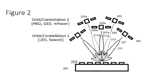
FIG. 2 is a multi-beam high-gain VSAT (Very Small-Aperture Terminal) antenna
configured to listen to a signal, such as the Telemetry, Tracking, & Control
(TT&C) signals, from
multiple satellites at different orbits and constellations in order to allow
computation of PNT
data by one or more of angular separation between satellites, trajectory of
individual satellites,
signal time of flight to each satellite, and doppler shift of the signals from
each satellite.
FIG. 3 is a multi-beam high-gain VSAT antenna with a receiver to measure the
signals
and a computing element to determine the location of the receiver.
CA 03164316 2022-06-10
WO 2021/140451
PCT/IB2021/050078
FIG. 4 is an antenna configured to receive a signal, such as the TT&C signals,
from each
of LEO (Low-Earth Orbit), MEC, (Medium-Earth Orbit), and GEO (Geostationary
Earth Orbit)
satellites.
FIG. 5 is the VSAT PNT system configured with one of several possible external
5 communications systems for accessing satellite ephemeris data: a)
bidirectional satellite link; b)
satellite broadcast; c) terrestrial wireless or wired communications network;
or d) stored
ephemeris data.
FIG. 6 is a process diagram for the operation of the antenna for computing
timing and
position data.
DETAILED DESCRIPTION OF THE INVENTION
As noted above, conventional GNSS and GPS systems make use of specially
crafted
signals in a dedicated frequency band to support and allow for high-precision
time and position
determination. The present system and method instead allow the determination
of position
and timing information without support from dedicated signals (as would be
readily available
from GNSS satellites) from the non-GNSS satellites in different frequency
bands than the GNSS
systems, and can include information from any transmitting non-GNSS satellite
in the
operational frequency band of the receiver. The present system relies on
simultaneously
receiving signals from multiple non-GNSS satellites in different directions
relative to the
receiver in order to compute the position, which requires a receiver to
generate multiple
antenna beams to receive the signals. This system operates non-cooperatively
because it does
not require the non-GNSS satellites to transmit special signals or even be
aware that the
receiver exists or that the signals are being used for PNT extraction at all.
For example, the
receiver might simultaneously extract timing synchronization signals
transmitted by the beacon
or independent TT&C link in the Ka or Ku SATCOM bands from multiple satellites
in the same or
different LEO communications or earth observation constellations and combine
the timing
information obtained from those signals with the timing information received
from a GEO or
MEC, satellite to generate a robust time and location estimate. Thus, the non-
GNSS satellites
can continue to transmit and receive the standard non-GNSS signals, with no
operational (or
noticeable) differences between when their signals are being used to compute
positions, and
CA 03164316 2022-06-10
WO 2021/140451
PCT/IB2021/050078
6
when they are not. The benefit to this non-cooperative approach is that there
is no way for a
third party to predict or know which satellites, signals, channels, or
frequencies are being used
for positioning by a particular end-user. This increases the reliability and
availability of the
positioning data, since there is no one system that can be jammed, spoofed, or
interfered with.
The principles and mathematics behind computing a position for the receiver
given
estimates of the distances from a set of known locations are well understood.
This disclosure
allows a new source of the necessary input data (the distances and locations
of the source
satellites) compared to a conventional GNSS system. Unlike a GNSS receiver
that listens with an
omnidirectional antenna to a known set of satellites that broadcast specific
data to allow
determination of position, the present system allows the calculation of
distances and locations
without support or dedicated signals from the satellite in frequency bands
that operate at
signal levels that require electrically-large, directive antennas to receive.
The present disclosure relates to a different method of obtaining times,
positions, and
distances to a distant satellite compared to conventional GNSS systems. This
system relies on
existing transmitted signals from the non-GNSS satellites, such as the beacon
transmissions
that are already present on all operating satellites for TT&C purposes. The
beacons are
narrowband signals modulated with station-keeping and other satellite-health
parameters.
Beacons are used by the satellite operator to manage the spacecraft, as well
as by users of the
satellite to help locate and lock onto the satellite for communication
purposes.
The biggest limitation with using non-GNSS satellites for passive geolocation
is
supporting the frequency bands of interest. Only a limited number of non-GNSS
satellites
operate in the L-band and other low frequency channels, since there is much
more bandwidth
available at the higher frequencies. However, the higher frequency
communication links are
generally designed for high-gain directional antennas in order to improve the
spectral efficiency
of their communication. Path losses and instantaneous bandwidths are larger at
the higher
frequencies, which requires either higher power to be transmitted from the
satellite, larger
(and heavier) directional antennas at both the satellite and the ground, or
both. Directional
antennas indicates the use of electrically large apertures with size
substantially larger than a
wavelength at the operational frequency, producing gain in the range of 10-70
dBi, and more
commonly 15-50 dBi, rather than an omnidirectional antenna (like a
conventional GNSS patch
CA 03164316 2022-06-10
WO 2021/140451
PCT/IB2021/050078
7
antenna) with typically 0-7 dBi gain. Directional ground antennas such as
parabolic reflectors
can typically only point in one direction at a time and can only listen to one
satellite at a time,
necessitating many antennas if signals from three or more satellites
simultaneously are
required.
The present disclosure removes this limitation using either a multi-beam
electrically-
steered phased array or lens array antenna. With this implementation, a single
antenna
aperture can generate multiple high-gain receive beams in different
directions, simultaneously
allowing (for example) a single terminal with a single antenna aperture to
passively listen to
multiple Ka-band satellites in different parts of the sky at the same time.
Only an electrically-
steered antenna such as a phased array, digital-beamforming array, liquid-
crystal antenna, or
lens array antenna is capable of generating multiple independent beams in
different, variable
directions, which is required for the operation of this system. In addition,
since the beams are
very narrow in angle, the direction and trajectory of the non-GNSS satellite
can be directly
measured, something that a conventional GPS receiver using an omnidirectional
antenna is not
able to do. By locking onto and passively listening to each satellite's
respective beacon signal
that carries TT&C data, timing information can be extracted. Locking onto the
beacon is done in
the same way as locking on to a communications satellite transponder, and uses
the beam
pointing capability of the antenna to track the satellite's location as the
satellite or the antenna
is in motion.
Passive operation is important in some applications, where strict emissions
control is
practiced. One of the benefits of conventional GNSS ground systems compared to
active
location systems like radar or transponders, is that their use is difficult to
detect because they
do not transmit signals, only receive signals from the GNSS satellites. The
present system has
the same advantage, unlike cooperative positioning methods using non-GNSS
satellites that
rely on measuring round-trip communications times (and therefore require
transmissions from
the receiver).
The non-GNSS satellite positions and trajectories will not be as tightly
determined as for
dedicated GNSS satellites, nor will the timing or position information on
board each satellite
that is broadcast as part of the communications or TT&C signals be as precise
or synchronized
between non-GNSS satellites. This will limit the accuracy that can be
obtained. However, in a
CA 03164316 2022-06-10
WO 2021/140451
PCT/IB2021/050078
8
case where GNSS constellations are jammed or disabled, an alternate method of
geolocation is
highly valuable, particularly when it can make use of many different
satellites. Changing from
dozens of GNSS satellites to hundreds or even thousands of non-GNSS satellites
that can be
used to determine even coarse position information provides a massive increase
in overall
system reliability and resilience, since it increases the difficulty of
jamming or blocking the
signals due to the increase in the number of satellites, as well as the
increase in the frequency
bands and spectrum that must be jammed.
Turning to FIGS. 2, 3, the satellite communication system 201 is shown having
an
antenna 202, receiver 305, signal processor 307, and digital processor 309.
The multi-beam
electrically-steered antenna 202 can be used to receive signals from (and
potentially transmit
signals to) multiple non-GNSS satellites 203, 205 at different orbits at once.
A receiver 305 is
provided for each beam 211, 213, 303 to receive and interpret the signals from
the satellite,
which will typically be the satellite beacon that contains data from which
time and position are
determined.
The signal processing apparatus 307 and digital processor 309 control the
antenna 202
and compute the location of the receiver based on the content of the received
signals. The
signal processing apparatus 307 and/or the digital processor 309 can each
include a processing
device, such as a processor or controller, computer, ASIC, or the like. The
signal processing
apparatus 307 conditions the signal and converts the waveform into a data
stream of
information that can then be provided to the digital processor 309, which can
be a controller.
The processor 309 combines the signals from all of the receivers 305 to
determine the position
by trilateration, and also monitors the signals to control the pointing
direction(s) of the
antenna 202. The antenna can be selected to operate at any frequency band
where non-GNSS
satellites are transmitting, including UHF, L, C, X, Ku, Ka, V, and W bands,
but the most value
will be at the higher frequencies (X and up, including the common VSAT Ku and
Ka bands)
where high antenna gain and narrow beam widths are easily achievable. High-
gain antennas
can receive and interpret low-power signals with reduced error rates. In one
illustrative, non-
limiting embodiment, the antenna and system operating are described operating
at below Ka
VSAT frequencies; selecting a VSAT band allows any of the existing
communications satellites to
be used, and also allows for future communications satellites (such as the LEO
networks) to be
CA 03164316 2022-06-10
WO 2021/140451
PCT/IB2021/050078
9
received. However, the system can be used by any satellite communications or
earth
observation band where satellites broadcast their TT&C information 207, 209.
The multi-beam antenna is commanded by the controller 309 to seek and locate
satellites within the field of view, based either on an estimate of the
current time and list of
satellite ephemeris that are predicted to be in view, or by a blind search of
the sky to locate
three or more satellites.
Once three or more non-GNSS satellites are located by the controller 309, and
the
antenna 202 commanded to steer a beam 303 to each satellite 203, 205, then the
receivers 305
receive the beacon transmissions from each satellite and extract the TT&C
signals 207, 209. The
information carried by the received signals is produced in the receivers 305,
further processed
and combined in the signal processing system 307 and then passed to the
digital processor 309
for analysis and final calculations of position and time. The received data
will include timing
information and potentially Keplerian elements for the satellite location in
addition to the
purely internal signals on satellite health of use only to the operator. The
time the signals were
transmitted from the satellite will be included in the transmission, and the
location of the
satellite when the signals were transmitted can be inferred based on the
satellite identification,
the time of transmission, and the ephemeris data obtained either from the
transmission itself
or an independent almanack.
The current time at the terminal is determined by the processor 309 by jointly
considering the information broadcast from all of the connected non-GNSS
satellites to
compute differences in time of travel among the three or more satellites. With
the time-of-
flight and the position of the satellites known at the current, known, time,
the processor 309
then computes the location of the receiver. The current time, time
differences, and positions
are computed in accordance with any suitable technique, such as the methods
used in GNSS.
Once even a rough time is known or estimated, further refinement to the
estimated satellite
locations can be generated based on the satellite ephemeris data. The accuracy
of the location
and time measurements will be affected by the accuracy and synchronization
between the
different non-GNSS satellites, as well as unavoidable variation of the signal
timing as the signals
propagate through the atmosphere. For example, a LEO constellation might have
a health
signal transmitted from each satellite that periodically transmits a timestamp
and a set of
CA 03164316 2022-06-10
WO 2021/140451
PCT/IB2021/050078
satellite-specific data. The timestamp transmissions would then form the basis
of the timing
calculations and position calculations.
Increased time accuracy, which will then result in increased position
accuracy, can be
obtained by including a miniaturized atomic clock or other high precision
timing reference
5 signal in the receiver 305 to improve holdover (time accuracy over time)
of the current time
estimate produced from the received satellite signals. The atomic clock
supplements and
stabilizes the clock signal derived from the non-GNSS satellite signals, and
allows signals to be
received from different satellites at different times and still allows
integration into the
following position and time estimates with a high degree of accuracy.
10 In one
embodiment shown in FIG. 5, the system 201 has an almanack or database 501
of ephemeris data of the various satellites that it may use to determine its
location, or a
method of obtaining such an almanack for all the satellites in the field of
view or the subset of
satellites for which it has a tracked location. GNSS systems include a
mechanism for distributing
timely and accurate almanacks of the entire system in a standard way within
the navigation
signal itself, but non-GNSS communications satellites and systems do not
distribute this data or
do not do so in a standard manner. Ephemeris data forming an almanack for a
non-GNSS
systems may be broadcast by the transmitted signal or TT&C link in the form of
Keplerian
elements or other formats, but will not generally be at the same level of
accuracy as provided
by the GNSS almanack. The positioning system 201 must know the locations of
the GNSS
and/or non-GNSS satellites whose signals it is receiving in order to determine
its own location.
Satellite ephemeris data change regularly as orbits are perturbed, so a method
of
regularly obtaining up-to-date almanacks is required. When starting "cold"
with no knowledge
of the time or position, some information is needed to make the first time and
position
estimate. The limited number and stable location of the geostationary
satellites mean that
their orbital data can be stored in the system's 201 memory 501 to allow for
an initial position
and time fix, even if the data is of limited accuracy. A cooperative, active
bidirectional satellite
link 505 established with one or more non-GNSS communications satellites would
then allow
requesting an updated almanack from the internet for ephemeris data for the
other non-GNSS
satellites that may not exist in the internal database. A cooperative method
that preserves the
passive nature of the receiver could be used as part of a greater system where
a satellite
CA 03164316 2022-06-10
WO 2021/140451
PCT/IB2021/050078
11
transponder or transponders are configured to continually broadcast the
ephemeris data
(forming an almanack) for a large number of non-GNSS satellites to allow the
positioning
system 201 to obtain an accurate almanack without requiring active
bidirectional
communication.
Alternately, depending on the application and availability, terrestrial
communications
systems such as a mobile network 503 or wireline connection could be used to
obtain almanack
information as well. If this system is used in a broader system, then almanack
information
could also be broadcast by one or more satellites 507 to maintain the benefits
of not requiring
active broadcasts from the receiver in order to determine location. This would
however require
.. support from the satellite side, even if the signals and system were not
specially designed for
supporting positioning.
The process for determining position and time of the system 201 has several
parts.
Once the position and time is determined, the system can utilize any suitable
analogous
algorithm and calculations, such as those used in standard GNSS system.
Referring to FIG. 6,
operation of the system is shown. On beginning 603 operation, each one of
multiple beams 605
are used to locate independent non-GNSS satellites, lock onto the satellites'
signals, and listen
for signals, step 607. Due to the difference in frequency band between the
GNSS and non-GNSS
satellites, it is unlikely that both sets of signals can be leveraged to
improve the resulting
position measurements.
Referring to Fig. 4, once a plurality of at least three beams have located and
locked to a
satellite, step 609, each of the beams then tracks 611 the respective
satellites over time until
they receive 613 signals 413, 423, 433 from the multiple non-GNSS satellites.
The current
positions of the satellites are computed by the signal processor 307 based on
the time and
almanack data in the almanack database 501. Once all the signals are
available, step 615, the
current time 619 is then computed 617. The collected signals from each of the
beams 621
received by 607 and 611 are then used to compute the distance 625 to the
respective satellites.
With all of the distances known, step 627, the position of the system 201 can
be computed,
step 629, based on the distances 437 between the system 201 and each of the
satellites 203,
205 and the known satellite locations by trilateration. If the measure of the
position, step 629,
.. is not sufficient, step 631, the process continues with each beam 609
tracking satellites 611 to
CA 03164316 2022-06-10
WO 2021/140451
PCT/IB2021/050078
12
receive their signals 613. If the measure of the position, step 629, is
sufficient, step 631, then
the position is known, step 633. The user using the system can then use that
position to replace
the information from an unavailable GNSS system, for example.
An alternate method is to make use of the time information and current
location of the
satellites, as well as to optionally measure 623 the angles 439 between the
satellites as seen by
the ground terminal. The angles 439 are derived from the beam locations, which
are known by
the terminal as it tracks the target satellites. Since the multi-beam antenna
would be tracking
each satellite with an independent beam, the angle of each beam 415, 425, 435
determines the
direction to each satellite 411, 421, 431. By measuring three or more angles,
the position of the
receiver can be determined by triangulation.
Satellites not in a Geostationary orbit move with respect to the ground. This
relative
movement can be tracked from the ground by monitoring the position, distance,
and received
angle to one or more Non-GeoStationary Orbit(NGS0) satellites 411, 421 over
time. In this way,
the perceived trajectory of the satellites is measured by the system 201 and
can be compared
with the expected trajectory from the ephemeris data; this additional
information can be used
to improve the accuracy of the position estimates. This method can be used
while the system
201 is either stationary or has local movement cancelled out in the
calculations using an inertial
motion unit (IMU), which includes accelerometer and gyroscope sensors and
performs dead-
reckoning to track the location of the unit without access to outside
references. Locally tracking
the relative motion and position of the system 201 with an IMU allows signals
received at
different times to be integrated into the overall position estimate using
processing methods
such as Kalman filtering, and ultimately allows greater accuracy of both time
and position than
could be obtained without the use of the IMU.
Doppler information from the frequency of received narrowband signals
throughout the
pass, which includes the beacon and TT&C links, can also provide tighter
estimates of
trajectory. For example, the rate of change of frequency of the beacon and
TT&C signal can be
used to estimate the midpoint of the pass and time when the satellite makes
its closest
approach, which can help to tighten estimates of time and line up current
position
measurements with reported ephemeris data. Including velocity or trajectory
from the doppler
shift as well as the time of flight and direction of arrival information in
the calculations of
CA 03164316 2022-06-10
WO 2021/140451
PCT/IB2021/050078
13
position improves estimates since the doppler shift is less subject to noise
and errors than the
timing signals themselves, and large apparent motion between position
measurements can be
checked with the velocity information to confirm that the apparent motion is
correct. This
trajectory over time can be compared with the almanack data and used to
improve the
accuracy of the local position calculations, since more information is then
available (velocity
and trajectory vectors) in combination with the known or constrained orbital
mechanics of the
satellite.
Ultimately, the position of the system 201 will be computed with more accuracy
by
combining the calculations based on distance from the satellites, angle from
the receiver to the
.. satellites, and the measured trajectory of the satellites, all combined
with the current time and
satellite orbital parameters as contained in the ephemeris data or almanack.
No matter which method or combination of methods are used to compute position,
the
uncertainty and error estimates of each measurement can be combined to
estimate the
resulting accuracy or error in the position estimate itself.
The orbit of the satellites used in this method is immaterial, as long as the
orbital
parameters can be obtained. Satellites all on the equatorial plane, even
though they are on a
single plane, can be used for position estimates away from the equator (since
from the equator
they will appear to be a line); this allows the use of GEO satellites or ME0
equatorial satellites.
Satellites with inclined orbits at MEC, and LEO offer some benefits that there
will always be
satellites passing nearly overhead, but the satellites will also be moving
rapidly and will be
more challenging to lock onto in the first place. The present system will
function for any single
or combination of orbits but will yield the most robust information and
accuracy estimates
when a combination of orbits and inclinations and satellite locations are
used.
In summary, the present disclosure is for a method and system for computing
the
current time and distance from a plurality of satellites as the input to a
computing device (such
as a processing device, e.g., controller or processor) that uses that
information to determine
the position of the receiver. What separates this system from GPS and existing
GNSS and other
positioning systems is that a multibeam, directive antenna (such as an antenna
suitable for
VSAT operation) is used to receive signals from satellites (such as Ku- and Ka-
band data
communications or TV broadcast satellites) that are too weak (and in a
different frequency
CA 03164316 2022-06-10
WO 2021/140451
PCT/IB2021/050078
14
band) to be received by an omnidirectional GNSS or other or low-gain antenna.
With the
multibeam, directive antenna, the present system can extract positioning data
from signals and
satellites that cannot ordinarily be used or are not readily usable (e.g., by
a GPS or GNSS
system).
The only way that an antenna can have multiple independently-steerable
directive
beams that can independently track satellites is electrically-steerable
antennas. In contrast,
mechanically-steered antennas can point in one direction at a time, and would
need multiple
antennas to perform the same action as a single multibeam antenna is able to
perform.
Potential timing references in existing satellite signals can include framing
structure in
communications and broadcast signals, synchronisation signals between
satellites and
controllers, or satellite health broadcasts and TT&C links. By receiving these
signals (which
cannot be received by existing GNSS and positioning systems), the receiver can
extract the
timing information and compute the distance and locations of the satellites,
and then derive
from that the position of the receiver.
Unlike positioning systems that make use of communications satellites, the
present
system does not rely on any particular signals to be available from the
satellite, but will work
with whatever signals are ordinarily being transmitted, i.e., the non-GNSS
satellites are non-
cooperative. In particular, the satellites used for positioning need not have
any knowledge that
their signals are being used for the purpose of positioning. The system does
not use satellite-
.. assisted positioning, where the round-trip signal time when actively
communicating with a
satellite is used to derive timing information, or the case where the
satellite (or satellite
constellation) is used to determine the position of the transmitter on the
ground and
communicate the position back to the receiver.
Any frequency band can be used, and the most flexible system would be when the
.. antenna and system can operate at and listen to different frequency bands.
However,
electrically-steered antennas that operate at multiple frequencies are
difficult to build and are
expensive. So, most practical systems will operate at a single band, with the
most common
communications systems bands being Ka and Ku for VSAT operation.
Numerous applications of the present system and method will readily occur to
those
skilled in the art. Therefore, it is not desired to limit the invention to the
specific examples
CA 03164316 2022-06-10
WO 2021/140451
PCT/IB2021/050078
disclosed or the exact construction and operation shown and described. Rather,
all suitable
modifications and equivalents may be resorted to, falling within the scope of
the invention.