Note: Descriptions are shown in the official language in which they were submitted.
CA 03172761 2022-08-18
WO 2021/202005 PCT/US2021/018206
CONTINUOUS-WAVE RADAR SYSTEM FOR DETECTING FERROUS AND NON-
FERROUS METALS IN SALTWATER ENVIRONMENTS
CROSS REFERENCES TO RELATED APPLICATIONS
[00011 This application is a continuation of U.S. Patent Application No.
17/033,046, filed
September 25, 2020, which claims the benefit of and priority to U.S.
Provisional Patent
Application No. 62/978,021, filed February 18, 2020. This application also
claims the benefit of
and priority to U.S. Provisional Patent Application No. 62/978,021, filed
February 18, 2020.
Each of these applications is incorporated herein by reference in its
entirety.
BACKGROUND OF THE INVENTION
100021 1. Field of the Invention
100031 The present invention relates to continuous-wave radar systems and
more specifically
to detecting ferrous and non-ferrous metals in saltwater environments.
100041 2. Description of the Prior Art
100051 It is generally known in the prior art to provide devices capable of
propagating
electromagnetic waves through bodies of water, including seawater and brackish
water.
[0006] Prior art patent documents include the following:
[0007] U.S. Patent Pub. No. 2016/0266246 for A system for monitoring a
maritime
environment by inventor Hjelmstad, field October 23, 2014 and published
September 15, 2016,
is directed to a system for monitoring a maritime environment, the system
including a plurality
of detection devices for detecting objects in the maritime environment, the
detection devices
being configured for object detection according to different object detection
schemes, and a data
processing device having a communication interface and a processor, wherein
the
communication interface is configured to receive detection signals from the
detection devices,
and wherein the processor is configured to determine locations of the objects
in the maritime
1
CA 03172761 2022-08-18
WO 2021/202005 PCT/US2021/018206
environment upon the basis of the received detection signals within a common
coordinate
system.
[0008] U. S. Patent Pub. No. 2013/0278439 for Communication between a
sensor and a
processing unit of a metal detector by inventor Stamatescu, et al., filed June
20, 2013 and
published October 24, 2013, is directed to a method for improving a
performance of a metal
detector, including: generating a transmit signal; generating a transmit
magnetic field based on
the transmit signal for transmission using a magnetic field transmitter;
sending a receive signal
based on a receive magnetic field received by a magnetic field receiver to a
processing unit of
the metal detector; sending a communication signal, including information from
a sensor, to the
processing unit; and processing the receive signal with the communication
signal to produce an
indicator output signal indicating a presence of a target under an influence
of the transmit
magnetic field; wherein one or more characteristics of the communication
signal are selected
based on the transmit signal to reduce or avoid an interference of the
communication signal to
the receive signal.
[00091 U.S. Patent No. 8,604,986 for Device for propagation of
electromagnetic waves
through water by inventor Lucas, filed May 14, 2009 and issued December 10,
2013, is directed
to an invention concerning a device for propagating electromagnetic waves
through impure water
such as seawater or brackish water. The device comprises a body of polar
material, for example
pure water, contained in an enclosure, and an antenna arranged to emit an
electromagnetic signal
into the polar material. Excitation of dipoles in the polar material by the
electromagnetic signal
causes them to re-radiate the signal, which is thereby emitted into and
relatively efficiently
propagated through the water in which the device is submerged. The device
offers the possibility
of improved underwater communication.
2
CA 03172761 2022-08-18
WO 2021/202005 PCT/US2021/018206
100101 U.S. Patent Pub. No. 2018/0267140 for High spatial resolution 3D
radar based on a
single sensor by inventor Corcos, et al., filed March 20, 2017 and published
September 20, 2018,
is directed to a novel system that allows for 3D radar detection that
simultaneously captures the
lateral and depth features of a target is disclosed. This system uses only a
single transceiver, a set
of delay-lines, and a passive antenna array, all without requiring mechanical
rotation. By using
the delay lines, a set of beat frequencies corresponding to the target
presence can be generated in
continuous wave radar systems. Likewise, in pulsed radar systems, the delays
also allow the
system to determine the 3D aspects of the target(s). Compared to existing
solutions, the
invention, in embodiments, allows for the implementation of simple, reliable,
and power efficient
3D radars.
[0011] U.S. Patent Pub. No. 2002/0093338 for Method and apparatus for
distinguishing
metal objects employing multiple frequency interrogation by inventor Rowan,
filed February 11,
2002 and published July 18, 2002, is directed to a method and apparatus for
distinguishing metal
objects employing multiple frequency interrogation. In one aspect, the method
includes
interrogating a target with at least two frequencies, obtaining respective
response signals for the
two frequencies, resolving the response signals into at least respective
resistive component
portions, comparing the magnitudes of at least two of the resistive component
portions, selecting
one response signal from among the response signals based on the comparison,
and
characterizing the target with the selected response signal. In other aspects,
the method includes
obtaining response data by interrogating the target at at least two
frequencies, normalizing the
response data and comparing the normalized response data. A signal is provided
indicating the
extent of any disagreement in the normalized response data.
3
CA 03172761 2022-08-18
WO 2021/202005 PCT/US2021/018206
[0012] U.S. Patent Pub. No. 2014/0012505 for Multiple-component
electromagnetic
prospecting apparatus and method of use thereof by inventor Smith, filed March
27, 2012 and
published January 9, 2014, is directed to systems and methods for the
detection of conductive
bodies using three-component electric or magnetic dipole transmitters. The
fields from multiple
transmitters can be combined to enhance fields at specific locations and in
specific orientation. A
one- two- or three-component receiver or receiver array is provided for
detecting the secondary
field radiated by a conductive body. The data from multiple receivers can be
combined to
enhance the response at a specific sensing location with a specific
orientation. Another method is
provided in which a three-component transmitter and receiver are separated by
an arbitrary
distance, and where the position and orientation of the receiver relative to
the transmitter are
calculated, allowing the response of a highly conductive body to be detected.
[0013] U.S. Patent No. 10,101,438 for Noise mitigation in radar systems by
inventor
Subburaj, et al., filed April 15, 2015 and issued October 16, 2018, is
directed to a noise-mitigated
continuous-wave frequency-modulated radar including, for example, a
transmitter for generating
a radar signal, a receiver for receiving a reflected radar signal and
comprising a mixer for
generating a baseband signal in response to the received radar signal and in
response to a local
oscillator (LO) signal, and a signal shifter coupled to at least one of the
transmitter, LO input of
the mixer in the receiver and the baseband signal generated by the mixer. The
impact of
amplitude noise or phase noise associated with interferers, namely, for
example, strong
reflections from nearby objects, and electromagnetic coupling from transmit
antenna to receive
antenna, on the detection of other surrounding objects is reduced by
configuring the signal shifter
in response to an interferer frequency and phase offset.
4
CA 03172761 2022-08-18
WO 2021/202005 PCT/US2021/018206
100141 U.S. Patent No. 7,755,360 for Portable locator system with jamming
reduction by
inventor Martin, filed April 21, 2008 and issued July 13, 2010, is directed to
a portable self-
standing electromagnetic (EM) field sensing locator system with attachments
for finding and
mapping buried objects such as utilities and with intuitive graphical user
interface (GUI)
displays. Accessories include a ground penetrating radar (GPR) system with a
rotating Tx.I.Rx
antenna assembly, a leak detection system, a multi-probe voltage mapping
system, a man-
portable laser-range finder system with embedded dipole beacon and other
detachable accessory
sensor systems are accepted for attachment to the locator system for
simultaneous operation in
cooperation with the basic locator system. The integration of the locator
system with one or more
additional devices, such as fault-finding, geophones and conductance sensors,
facilitates the
rapid detection and localization of many different types of buried objects.
1.00151 U.S. Patent No. 8,237,560 for Real-time rectangular-wave
transmitting metal detector
platform with user selectable transmission and reception properties by
inventor Candy, filed
October 11, 2011 and issued August 7, 2012, is directed to a highly flexible
real-time metal
detector platform which has a detection capability for different targets and
applications, where
the operator is able to alter synchronous demodulation multiplication
functions to select different
types or mixtures of different types to be applied to different synchronous
demodulators, and
also different waveforms of the said synchronous demodulation multiplication
functions;
examples of the different types being time-domain, square-wave, sine-wave or
receive signal
weighted synchronous demodulation multiplication functions. The operator can
alter the
fundamental frequency of the repeating switched rectangular-wave voltage
sequence, and an
operator may alter the waveform of the repeating switched rectangular-wave
voltage sequence
and corresponding synchronous demodulation multiplication functions.
CA 03172761 2022-08-18
WO 2021/202005 PCT/US2021/018206
[0016] U.S. Patent Pub. No. 2005/0212520 for Subsurface electromagnetic
measurements
using cross-magnetic dipoles by inventor Homan, et al., filed March 29, 2004
and published
September 29, 2005, is directed to sensor assemblies including transmitter and
receiver antennas
to respectively transmit or receive electromagnetic energy. The sensor
assemblies are disposed in
downhole tools adapted for subsurface disposal. The receiver is disposed at a
distance less than
six inches (15 cm) from the transmitter on the sensor body. The sensor
transmitter or receiver
includes an antenna with its axis tilted with respect to the axis of the
downhole tool. A sensor
includes a tri-axial system of antennas. Another sensor includes a cross-
dipole antenna system
[0017] U.S. Patent Pub. No. 2017/0307670 for Systems and methods for
locating and/or
mapping buried utilities using vehicle-mounted locating devices by inventor
Olsson filed April
25, 2017 and published October 26, 2017, is directed to systems and methods
for locating and/or
mapping buried utilities. In one embodiment, one or more magnetic field
sensing locating
devices include antenna node(s) to sense magnetic field signals emitted from a
buried utility and
a processing unit to receive the sensed magnetic field signals may be mounted
on a vehicle. The
received magnetic field signals may be processed in conjunction with sensed
vehicle velocity
data to determine information associated with location of the buried utility
such as depth and
position.
[0018] U.S. Patent Pub. No. 2011/0136444 for Transmit and receive antenna
by inventor
Rhodes, et al., filed December 9, 2009 and published January 9, 2011, is
directed to a
transmit/receive antenna for transmission and reception of electromagnetic
signals. The
transmit/receive antenna comprises a TX section and an RX section, where the
TX section
comprises a magnetically coupled TX element and a TX input terminal and the RX
section
comprises at least one magnetically coupled RX element and has an RX output
terminal. Axes of
6
CA 03172761 2022-08-18
WO 2021/202005 PCT/US2021/018206
the TX loop element and the at least one magnetically coupled RX solenoid
element are parallel.
Moreover, the at least one magnetically coupled RX element is positioned to
provide high
isolation at the RX terminal of the antenna from TX electrical signals fed to
the TX input
Specifically, the at least one magnetically coupled RX element is positioned
at a so that the net
magnetic flux generated by the TX loop element and threading the RX solenoid
element is zero.
[0019] U.S. Patent Pub. No. 2008/0224704 for Apparatus and method for
detecting and
identifying ferrous and non-ferrous metals by inventor Westersten, filed
September 9, 2005 and
published September 18, 2008, is directed to a metal detector using a linear
current ramp
followed by an abrupt current transition to energize the transmitter coil. The
constant emf
imposed on the target during the current ramp permits separation of transient
voltages generated
in response to eddy currents in the target and its environment from the
voltages arising as a result
of an inductive imbalance of the coil system. The temporal separation of the
various voltages
makes reliable differentiation between ferrous and non-ferrous targets
possible.
100201 SUMMARY OF THE INVENTION
100211 The present invention relates to a radar system, and particularly a
continuous-wave
(CW) radar system for detecting ferrous and non-ferrous metals in saltwater
environments.
100221 It is an object of this invention to provide a CW radar system for
detecting ferrous
and non-ferrous metals in saltwater environments, increasing radar geolocation
accuracy,
enabling the identification of the type of material of a target object,
discriminating between
ferrous and non-ferrous target objects, and mapping target objects onto a 2D
and 3D coordinate
system.
[0023] In one embodiment, the present invention includes a CW radar system
for detecting
ferrous and non-ferrous metals in saltwater environments.
7
CA 03172761 2022-08-18
WO 2021/202005 PCT/US2021/018206
[0024] in another embodiment, the present invention includes a method for
using a CW radar
system to detect ferrous and non-ferrous metals in saltwater environments.
[0025] In one embodiment, the present invention includes a CW radar system
for geolocating
ferrous and non-ferrous metals in saltwater environments.
[0026] In one embodiment, the present invention includes a CW radar system
for identifying
ferrous and non-ferrous metal types in saltwater environments.
[0027] In one embodiment, the present invention includes a CW radar system
for
discriminating between ferrous and non-ferrous metals in saltwater
environments.
[0028] In one embodiment, the present invention includes a CW radar system
for mapping in
two dimensions (2D) and three dimensions OD) ferrous and non-ferrous metals in
saltwater
environments.
[0029] These and other aspects of the present invention will become
apparent to those skilled
in the art after a reading of the following description of the preferred
embodiment when
considered with the drawings, as they support the claimed invention.
BRIEF DESCRIPTION OF THE DRAWINGS
[0030] FIG. 1A illustrates a block diagram of a continuous-wave (CW) radar
system
according to one embodiment of the present invention.
[0031] FIG. 1B illustrates a pipe frame for a CW radar system according to
another
embodiment of the present invention.
[0032] FIG. 1C illustrates a CW radar system according to yet another
embodiment of the
present invention.
[0033] FIG. 1D illustrates the CW radar system of FIG. 1C showing the
location of antennas
in the piping according to another embodiment of the present invention.
8
CA 03172761 2022-08-18
WO 2021/202005 PCT/US2021/018206
100341 FIG. lE illustrates a side view of a CW radar system according to
one embodiment of
the present invention.
[00351 FIG. IF illustrates a top view of a CW radar system according to one
embodiment of
the present invention.
[00361 FIG. 1G illustrates a port view of a CW radar system according to
one embodiment of
the present invention.
[00371 FIG. 1H illustrates a radar corner reflector used during calibration
of the CW radar
system according to one embodiment of the present invention.
[00381 FIG. 2 illustrates an antenna setup for Transmitter (Tx) and
Receiver (Rx) antennas
for a CA' radar system according to one embodiment of the present invention.
[00391 FIG. 3A illustrates a cross-polarization orientation for Tx and Rx
antennas according
to one embodiment of the present invention.
[00401 FIG. 3B illustrates a cross-polarization orientation for Tx and Rx
antennas according
to another embodiment of the present invention.
100411 FIG. 3C illustrates a cross polarization orientation for Tx and Rx
antennas according
to another embodiment of the present invention.
100421 FIG. 4 illustrates an antenna setup for Tx and Rx antennas for a CW
radar system
according to one embodiment of the present invention.
[00431 FIG. 5 illustrates an antenna setup for Tx and Rx antennas with an
indication of return
length differences between Rx antennas for a CW radar system according to one
embodiment of
the present invention.
[00441 FIG. 6 illustrates a phase shift between Rx antennas for a CW radar
system according
to one embodiment of the present invention.
9
CA 03172761 2022-08-18
WO 2021/202005 PCT/US2021/018206
100451 FIG. 7A illustrates variances in signal strength between Rxi and Rx2
antennas for the
Rxi antenna according to one embodiment of the present invention.
[0046] FIG. 7B illustrates variances in signal strength between Rxi and Rx2
antennas for the
Rx2 antenna according to one embodiment of the present invention.
[0047] FIG. 7C illustrates variances in frequency using a lower frequency
according to on
embodiment of the present invention.
[0048] FIG. 7D illustrates variances in frequency using a Tx frequency
according to one
embodiment of the present invention.
[0049] FIG. 7E illustrates variances in frequency when using a higher
frequency according to
one embodiment of the present invention.
[0050] FIG. 8 illustrates object detection ranges for a CW radar system
according to one
embodiment of the present invention.
[005Ii FIG. 9 illustrates a precision detector for a CW radar system
according to one
embodiment of the present invention.
100521 FIG. 10 illustrates a graph indicating constructive and destructive
zones associated
with locating an object in a saltwater environment according to one embodiment
of the present
invention.
[0053] FIG. 11A illustrates a graph indicating constructive and destructive
zones created by
a boat and a dinghy associated with locating an object in a saltwater
environment according to
one embodiment of the present invention.
10054] FIG. 11B illustrates a graph indicating the energy product for a CW
radar system
according to one embodiment of the present invention.
CA 03172761 2022-08-18
WO 2021/202005
PCT/US2021/018206
[00551 FIG. 11C illustrates a graph indicating antenna signal strength
associated with
constructive and destructive zones of a CW radar system according to one
embodiment of the
present invention.
[0056] FIG. 11D illustrates a graph indicating a fore and aft antenna
energy product
associated with constructive and destructive zones of a CW radar system
according to one
embodiment of the present invention.
[0057] FIG. 12A illustrates a three-dimensional (3D) underwater depth map
indicating no
objects detected by a CW radar system according to one embodiment of the
present invention.
[0058] FIG. 12B illustrates a 3D underwater depth map indicating multiple
objects detected
by a CW radar system according to one embodiment of the present invention.
[0059] FIG. 13A illustrates a 3D underwater depth map indicating the
location of objects
according to one embodiment of the present invention.
[0060i FIG. 13B lists all of the labels in FIG. 13A representing different
geographic
locations for detected objects according to one embodiment of the present
invention.
[006Ii FIG. 14A illustrates a two-dimensional (2D) underwater depth map
indicating
location coordinates for a detected object according to one embodiment of the
present invention.
[0062] FIG. 14B lists all of the labels in FIG. 14A representing different
geographic
locations for detected objects according to another embodiment of the present
invention.
[0063] FIG. 15A illustrates a 2D underwater depth map indication location
coordinates for
detected objects according to another embodiment of the present invention.
[0064] FIG. 15B lists all the labels in FIG. 15A representing different
geographic locations
for detected objects according to one embodiment of the present invention.
11
CA 03172761 2022-08-18
WO 2021/202005 PCT/US2021/018206
[0065] FIG. 16A illustrates a surveying operation with a CW radar system
according to one
embodiment of the present invention.
[0066] FIG. 16B illustrates a surveying operation with a CW radar system
connected to a
towing vessel according to one embodiment of the present invention.
[0067] FIG. 17A illustrates a 2D underwater heatmap indicating the
geolocation of detected
objects according to one embodiment of the present invention.
[0068] FIG. 17B lists all of the labels in FIG. 17A representing different
priority zones on a
2D underwater heatmap for a CW radar system according to one embodiment of the
present
invention.
[0069] FIG. 18 illustrates a 2D underwater heatmap indicating the
geolocation of detected
objects according to another embodiment of the present invention.
[0070] FIG. 19A illustrates a 2D underwater heatmap indicating the
geolocation of detected
objects according to another embodiment of the present invention.
[007I] FIG. 19B lists all of the labels in FIG. 19A representing different
priority zones on a
2D underwater heatmap for a CW radar system according to one embodiment of the
present
invention.
[0072] FIG. 20A illustrates a 2D underwater heatmap indicating a CW radar
system traveling
path and the geolocation of detected objects according to another embodiment
of the present
invention.
[0073] FIG. 20B lists all the labels in FIG. 20A representing different
geographic locations
for detected objects according to one embodiment of the present invention.
[0074] FIG. 21A illustrates a 2D graph indicating a land mass and a travel
route for a CW
radar system according to one embodiment of the present invention.
12
CA 03172761 2022-08-18
WO 2021/202005 PCT/US2021/018206
[0075] FIG. 21B illustrates a 2D heatmap graph indicating a travel route
for a CW radar
system according to one embodiment of the present invention.
[0076] FIG. 22A illustrates a circuit diagram of an amplifier board for a
CW radar system
according to one embodiment of the present invention.
[0077] FIG. 22B illustrates a pin configuration diagram for an amplifier
board for a CW
radar system according to one embodiment of the present invention.
[0078] FIG. 22C illustrates a pin connection diagram for an amplifier board
for a CW radar
system according to one embodiment of the present invention.
[0079] FIG. 22D illustrates a pin configuration and function diagram for an
amplifier board
for a CW radar system according to another embodiment of the present
invention.
10080] FIG. 22E illustrates a pin configuration and function diagram for an
amplifier board
for a CW radar system according to another embodiment of the present
invention.
[0081] FIG. 22F illustrates a chart depicting the flow of signal through an
amplifier board for
a CW radar system according to one embodiment of the present invention.
[0082] FIG. 23 lists a table for a primary gain stage of an amplifier board
for a CW radar
system according to one embodiment of the present invention.
[0083] FIG. 24 lists a table for a secondary gain stage of an amplifier
board for a CW radar
system according to one embodiment of the present invention.
[0084] FIG. 25 lists a table for Stage One and Stage Two gain settings for
an amplifier board
for a CW radar system according to one embodiment of the present invention.
[0085] FIG. 26 lists a table for gain calculations for an amplifier board
for a CW radar
system according to one embodiment of the present invention.
13
CA 03172761 2022-08-18
WO 2021/202005 PCT/US2021/018206
100861 FIG. 27 lists a table for Stage One and Stage Two gain settings for
an amplifier board
for a CW radar system according to another embodiment of the present
invention.
100871 FIG. 28A lists a table for resistance values for an amplifier board
for a CW radar
system according to one embodiment of the present invention,
100881 FIG. 28B lists a table for additional resistance values for an
amplifier board for a CW
radar system. according to one embodiment of the present invention,
100891 FIG. 28C lists a table for additional resistance values for an
amplifier board for a CW
radar system according to one embodiment of the present invention,
100901 FIG. 29 illustrates an amplifier board for a CW radar system
according to another
embodiment of the present invention.
100911 FIG. 30 illustrates an amplifier board for a CW radar system
according to another
embodiment of the present invention.
[0092] HG. 31A illustrates the top of an impedance matching board for a CW
radar system
according to one embodiment of the present invention.
[0093] HO. 31B illustrates the bottom of an impedance matching board for a
CW radar
system according to one embodiment of the present invention.
100941 FIG. 32 illustrates a graphical user interface (GUI) for displaying
objects detected by
a CW radar system according to one embodiment of the present invention.
[00951 FIG. 33 illustrates a GUI for displaying objects detected by a CW
radar system
according to one embodiment of the present invention.
100961 FIG. 34 illustrates a sonar GUI for a CW radar system according to
one embodiment
of the present invention.
14
CA 03172761 2022-08-18
WO 2021/202005 PCT/US2021/018206
100971 FIG. 35 illustrates a travel route GUI for a CW radar system
according to one
embodiment of the present invention.
[00981 FIG. 36A illustrates a two-dimensional (2D) map indicating a log
scale of a
normalized energy product for a CW radar system with no detected targets
according to one
embodiment of the present invention.
[0099] FIG. 36B illustrates a 2D map indicating a log scale of a normalized
energy product
for a CW radar system with detected targets according to another embodiment of
the present
invention.
[001001 FIG. 37A illustrates a 2D density and intensity map for a CW radar
system according
to one embodiment of the present invention.
[00101] FIG. 37B illustrates a 2D density map for a CW radar system according
to one
embodiment of the present invention.
[001021 FIG 38 illustrates a GUI for displaying energy and frequency data
associated with a
CW radar system according to one embodiment of the present invention.
[001031 FIG 39 illustrates a GUI for displaying phase detail and power history
data associated
with a CW radar system according to one embodiment of the present invention.
1001041 FIG. 40 is a schematic diagram of a system of the present invention.
1001051 FIG. 41 illustrates an amplifier board for a CW radar system according
to one
embodiment of the present invention.
[001061 FIG. 42 illustrates an amplifier board for a CW radar system according
to another
embodiment of the present invention.
[00107] FIG. 43 illustrates an amplifier board for a CW radar system according
to yet another
embodiment of the present invention.
CA 03172761 2022-08-18
WO 2021/202005 PCT/US2021/018206
1001081 FIG. 44 illustrates an amplifier board for a CW radar system according
to yet another
embodiment of the present invention.
[00109] FIG. 45 illustrates an amplifier board for a CW radar system according
to yet another
embodiment of the present invention.
[0011.01 FIG. 46 illustrates an amplifier board for a CW radar system
according to yet another
embodiment of the present invention.
DETAILED DESCRIPTION
[0011.1.1 The present invention is generally directed to a continuous-wave
(CW) radar system
for detecting ferrous and non-ferrous metals in saltwater environments, as
well as methods of
using the CW radar system to detect ferrous and non-ferrous metals in
saltwater environments.
[0011.2] In one embodiment, the present invention includes a CW radar system
for detecting
ferrous and non-ferrous metals in saltwater environments.
[001131 In another embodiment, the present invention includes a method for
using a CW radar
system to detect ferrous and non-ferrous metals in saltwater environments.
[001141 None of the prior art discloses the use of extremely-low frequency
(ELF)
electromagnetic (EM) waves in saltwater to pinpoint and/or locate ferrous and
non-ferrous
metals.
[001151 Current underwater detection and surveying technologies make use of
magnetometers
which are only able to measure magnetism in ferrous materials, such as iron or
steel.
Magnetometers are unable to detect non-ferrous metals such as gold, silver,
copper, brass,
bronze, aluminum, molybdenum, zinc, or lead. In addition, magnetometers only
detect the
strength, or relative change of the Earth's magnetic field at a particular
location, and are strictly
passive sensors. Thus, magnetometers only use the natural, surrounding
magnetism of an object,
16
CA 03172761 2022-08-18
WO 2021/202005 PCT/US2021/018206
relying solely on the Earth's fixed magnetic output as the transmitter (Tx).
In such a system, only
the magnetometer as the receiver (Rx) portion can be modified or manipulated.
Moreover,
magnetometers have a fixed range based on receiver sensitivity which results
in a minimal
detection range for ferrous-only materials.
[00116] While sub-bottom sonar, side scanning sonar, dual band metal
detectors, ground
penetrating radar (GPR), and pulsed-wave (PW) radar techniques are also
available, these
detection technologies are subject to faults and limitations that make their
usage in saltwater
environments impractical.
[00117] Sub-bottom sonar systems are able to penetrate the ocean floor, but
cannot identify,
locate, or differentiate between sedimentary material, ferrous material, and
non-ferrous material.
These systems can only detect "acoustic" impedance, which provides for
determining changes in
density from one stratigraphic layer to another stratigraphic layer of the
subsurface geology.
Acoustic impedance corresponds to a physical "pressure" wave (e.g., sound,
physical vibrations,
earthquakes, etc.), while "electrical" impedance corresponds to an
electromagnetic wave (e.g.,
signals from radio, cell phones, microwaves, light, etc.). Typically, sub-
bottom sonar systems
operate in the acoustic range of 5-50 kilohertz (kHz). While lower frequencies
penetrate deeper
into mud and silt, these systems lack the ability to provide real detail of
the detected layers. In
contrast, higher frequencies provide minor surface layer detail, but lack the
ability to penetrate
sand, mud, or silt.
100118i Side-scanning sonar is typically used to create a map of the ocean
bottom. However,
much like sub-bottom sonar, side-scanning sonar lacks the ability to penetrate
into the surface of
the ocean bottom. The devices utilized for side-scanning sonar are also
acoustic-only devices.
I 7
CA 03172761 2022-08-18
WO 2021/202005 PCT/US2021/018206
(00119.1 Dual band metal detectors are also used in underwater salvaging.
These systems are
active systems and are able to identify ferrous and non-ferrous metals using
dual frequency
differences to determine metal types (i.e., ferrous vs. non-ferrous). Dual
band metal detectors
operate in the 5-100 kilohertz (kHz) range and are typically able to penetrate
between 3 inches
(about 7.62 cm) to 18 inches (about 45.72 cm) of sand, saltwater, soil, etc.
In addition, dual band
metal detectors are restricted to searching an area directly under the
detector unit's coil diameter,
which is typically less than 12 inches (about 30.48 cm) in diameter.
[00120] Ground penetrating radar (GPR) systems are used only in air
environments. The
frequency of GPR falls between 10-3000 megahertz (MHz). Even if a GPR system
was
encapsulated for ocean use, the radar energy would immediately be absorbed on
contact with
saltwater and its effective range would be less than an inch (about 2.54 cm).
High frequency,
commercial, hand-held metal detectors used on the land have the ability to not
only detect metal
objects (typically <6 ft or about 1.828 meters away), but are also able to
classify what type of
metal the object is made of (i.e., gold, silver, iron, etc.). This is
accomplished through the
differences between the multiple radar bands. In multiple signal systems,
signals reflect off of the
metal, but based on the metal material, the strength and phase of return
between the frequencies
is different. However, the frequencies of these commercial metal detectors do
not transmit far
enough in saltwater environments before being completely absorbed by the water
and hence are
operationally ineffective.
[00121] Pulsed-wave (PW) radar systems transmit electromagnetic (EM) waves
during a time
duration, or pulse width. During this process, the receiver is isolated from
the antenna in order to
protect the receiver's sensitive components from a transmitter's high-power EM
waves. No
received signals can be detected during this time.
18
CA 03172761 2022-08-18
WO 2021/202005 PCT/US2021/018206
1001221 The faults and limitations of the previously mentioned detection and
sensor
technologies have led to the present invention: a continuous-wave (CW) radar
system for
detecting ferrous and non-ferrous objects in saltwater environments. Such a
radar system
combines all of the positive attributes of current sensor and Median
technologies with none of
the limitations or faults. Instead of relying on "acoustic" waves, the system
uses
"electromagnetic" waves, but at frequencies which allow for greater
penetration than even the
most sophisticated sub-bottom sonar systems.
[001231 The CW radar system generates ELF electromagnetic (EM) waves and uses
those
waves to perform functions including, but not limited to, detection, location,
and classification of
objects of interest. Such objects include, but are not limited to, all types
of ferrous and non-
ferrous metals, as well as changing material boundary layers (e.g., soil to
water, sand to mud,
rock to organic materials, etc.). In one embodiment, the ELF waves used are
between 100 Hz and
3000 Hz. The CW radar system is operable to detect and record all frequencies
below
approximately 3000 Hz. Thus, the ELF waves are operable to propagate through
water, soil,
sand, rock, and/or metals. A portion of the ELF waves are reflected off of
thicker metals and
boundary layers, which are used to perform functions including, but not
limited to, detection,
location, analysis, mapping, and/or classification of objects. This entire
process is performed
using short, manageable antennas which are operable to transmit and receive
the same ELF
waves or signals. Thus, the present invention is operable to identify both
ferrous and non-ferrous
metals.
[001241 In one embodiment, the CW radar system of the present invention makes
use of a
multi-band system capable of operating at simultaneous frequencies in order to
decrease location
19
CA 03172761 2022-08-18
WO 2021/202005 PCT/US2021/018206
error and provide the ability to specifically identify the type of metal
associated with an object
and/or target during operations.
[00125] A key element of this system is the environment it functions in:
saltwater. Saltwater is
conductive and distributed equally around the system's sensors. The saltwater
becomes a barrier
to transmission, due to absorption, but simultaneously ads as a filter to keep
the detection ranges
local to the sensor. Without a saltwater environment, the transmission ranges
measure in
kilometers instead of meters. All conductive surfaces within a few kilometers
would create a
return signal and greatly reduce the ability to locate a specific target,
local to the sensors.
Saltwater changes the effective wavelength from potentially thousands of
kilometers to less than
100 meters, enabling detection of targets, as well as localization of objects
around the system's
sensors from a few meters to a few hundred meters, based on Tx signal strength
and Rx
sensitivity. In one embodiment, the system can handle variations in salinity
within at least a 50
mile radius without further adjustment. In another embodiment, the system can
be recalibrated at
startup andlor when the saltwater environment changes to accommodate different
levels of
salinity. In one embodiment, the system is operable to detect targets and/or
objects in brackish
water.
1001261 The CW radar system is operable to function in deep saltwater
environments, from
tens of feet to tens of thousands of feet (or tens of meters to thousands or
tens of thousands of
meters). Moreover, the design of the CW radar system of the present invention
prevents saltwater
from contaminating the towing device(s) connected to a collecting and/or
towing vehicle. The
CW radar system is capable of determining absolute object and/or target
geolocation to within <
4 meters (m) circular error probable (CEP) of accuracy. The CW radar system is
also capable of
providing object and/or target geolocation within <2 m CEP of accuracy using a
relative
CA 03172761 2022-08-18
WO 2021/202005 PCT/US2021/018206
positioning system. In one embodiment, relative positioning is determined
through the use of a
relative GPS receiver. In another embodiment, the relative positioning of
detected targets is
determined with respect to known metal targets or markers placed within the
field of search.
[00127] Referring now to the drawings in general, the illustrations are for
the purpose of
describing one or more preferred embodiments of the invention and are not
intended to limit the
invention thereto.
[00128] The continuous-wave (CW) radar system of the present invention
utilizes a
combination of transmitter (Tx) and receiver (Rx) antennas. By using multiple
Rx antennas, the
system is able to localize objects.
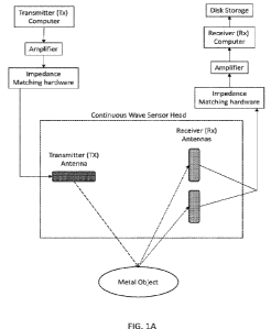
[00129] FIG. I A illustrates a block diagram of a continuous-wave (CW) radar
system
according to one embodiment of the present invention. The components include,
but are not
limited to, a transmitter computer, a receiver computer, at least two
amplifiers, a storage
component, at least two impedance matching hardware components coupled to the
at least two
amplifiers, a continuous wave sensor head (the submerged, towed structure
comprising the
Transmitter (Tx), Receiver (Rx) antennas, down plane, horizontal stabilizer,
floatation elements,
and structural support elements), a tow point, a Tx communications cable, a Rx
communications
cable. The continuous wave sensor head is comprised of at least one
transmitter (Tx) antenna and
at least two receiver (Rx) antennas. The submersion of the Tx and Rx antennas
in a saltwater
environment modifies the relative Tx and Rx wavelengths from thousands of
kilometers to less
than a few hundred of meters range. This enables the use of electrically short
dipole antennas to
collect enough energy, at the Rx antennas, to detect, locate, and/or identify
all types of ferrous
and non-ferrous metals.
21
CA 03172761 2022-08-18
WO 2021/202005 PCT/US2021/018206
1001301 FIG. 1B illustrates a pipe frame for a CW radar system according to
another
embodiment of the present invention. The CW radar system is comprised of a
multitude of
piping, operable to house at least one Tx antenna and at least two Rx antennas
1001311 FIG. IC illustrates a CW radar system according to yet another
embodiment of the
present invention. The CW radar system is comprised of components including,
but not limited
to, a tow point, a Rx/Tx communications cable, a down plane, a horizontal
stabilizer, at least one
Tx antenna, and/or at least two Rx antennas. The tow point is positioned to
maximize the
stability of the CW radar system while it is being towed from a towing vessel.
In one
embodiment, the towing vessel is a watercraft, including but not limited to a
boat, ship, Jet Ski,
or submarine. In another embodiment, the towing vessel is an underwater
Remotely Operated
Vehicle (ROV). In another embodiment, the towing vessel is an Unmanned
Underwater Vehicle
(UUC). The tow point also helps keep the tow cable separate from the data
cable. The data cable
enters the CW radar system above and behind the tow point on top of the CW
radar system. The
data cable has multiple electrically shielded wires running throughout the
structure to each of the
six antennas, four Rx antennas and two Tx antennas. Furthermore, the path of
the data cable
throughout the CW radar system is also important, as the cable(s) are run in
order to maximize
their individual cross polarization to the Tx antennas. By positioning the Tx
antennas at a 90-
degree angle in relation to the Rx antennas, this prevents the Rx antenna's
wiring from coming
into contact with the Tx antenna output pattern, further reducing the
crosstalk from the Tx
antennas into the Rx antenna data cable(s). The 90-degree angle between Tx and
Rx antennas
also provides for the majority of the direct path attenuation through the use
of the polarization
properties of dipole antennas. Without this attenuation, signal from the Tx
antenna would
22
CA 03172761 2022-08-18
WO 2021/202005 PCT/US2021/018206
saturate the Rx antenna and any returning signal from a target would be lost
due to the much,
much stronger direct path signal.
[00132] FIG. ID illustrates the CW radar system of FIG. IC showing the
location of antennas
in the piping according to another embodiment of the present invention. The CW
radar system is
comprised of components including, but not limited to, at least two bow Rx
antennas, at least
two Tx antennas placed approximately at the center of the CW radar system, and
at least two aft
Rx antennas. In one embodiment, the at least two Tx antennas are positioned
near a horizontal
stabilizer for the CW radar system. In one embodiment, the Tx and Rx antennas
are dipole
antennas. When two dipole antennas are placed in close proximity to one
another, this sets up a
transformer-like condition, resulting in a loss of power to the radar system
if each antenna is too
close to the other. As in a transformer, energy from one Tx antenna is
absorbed by any adjacent
Tx antenna. This results in a direct loss of usable power and requires the
system to also prevent
this lost energy/power from feeding back in to either Tx antenna's circuitry.
In order to minimize
these effects, the CW radar system of the present invention has been
constructed with a
functional distance built into the structure, holding the radar antennas
separate. This functional
distance is a function of how much transmitted energy loss is acceptable for
the CW radar system
and the specific transmitted frequencies being used. In one embodiment, the
range for acceptable
energy loss is between 5-200/. In one embodiment, the antennas are placed
between
approximately 9-24 inches (about 22.86 cm to about 60.96 cm) away from each
other to maintain
acceptable energy loss wherein the distance is inversely proportional to the
amount of energy
loss. Where the Rx antennas are also dipole antennas, the Tx antennas must be
angled 90-degrees
or near-90-degrees with respect to the Rx antennas in order to maximize the
benefits of cross
polarization. In another embodiment, the Tx and Rx antennas are short dipole
antennas. In
23
CA 03172761 2022-08-18
WO 2021/202005 PCT/US2021/018206
another embodiment, the Tx and Rx antennas are half-wave dipole antennas. In
another
embodiment, the Tx and Rx antennas are folded dipole antennas. In yet another
embodiment, the
Tx and Rx antennas are bow-tie dipole antennas. In yet another embodiment, the
Tx and Rx
antennas are cage dipole antennas. In yet another embodiment, the Tx and Rx
antennas are halo
dipole antennas. In yet another embodiment, the Tx and Rx antennas are
turnstile dipole
antennas. In yet another embodiment, the Tx and Rx antennas are sloper dipole
antennas. In yet
another embodiment, the Tx and Rx antennas are inverted "V" dipole antennas.
In yet another
embodiment, the Tx and Rx antennas are G5RV dipole antennas. In yet another
embodiment, the
Tx and Rx antennas are not dipole antennas.
[001331 In one embodiment, a Tx antenna is placed in one of two center pipes
and the
corresponding Rx antenna pair(s) are perpendicular to the Tx antenna, forward
and aft. Each Rx
antenna is placed approximately 1-3 meters from the Tx antenna. The Rx antenna
pair(s) are
always perpendicular or substantially perpendicular to the Tx antenna in order
to take advantage
of the noise cancellation provided by the polarization characteristics of the
antennas. In one
embodiment, one Tx antenna effectively has four Rx antennas, two forward and
two aft, with
each Rx antenna spaced approximately 1-2 meters away from the Tx antenna. In
one
embodiment, the Tx and Rx antennas are spaced approximately 60 inches apart
(about 152.4 cm)
from each other. In one embodiment, the Tx and Rx antenna structures are
approximately 14.5
feet (about 4.42 meters) in total when using a multiband system.
[00134] The addition of multiple Rx antennas facilitates the detection of
signal strength and
phase changes between the Rx antennas. Each Rx antenna remains perpendicular
or substantially
perpendicular to the surface of the water, while the Tx antenna(s) remain
parallel or substantially
parallel to the water's surface. This keeps the Tx and Rx antennas at right
angles to each other,
24
CA 03172761 2022-08-18
WO 2021/202005 PCT/US2021/018206
preventing self-jamming and shielding the Rx antennas from the water's surface
reflection. Thus,
this orientation functions to prevent self-jamming and reduce the surface
bounce energy from the
Tx into the Rx antenna(s).
[00135] In one embodiment, the CW radar system includes a third Tx./Rx antenna
combination. In another embodiment, the CW radar system includes a fourth
Tx/Rx antenna
combination. In yet another embodiment, the CW radar system includes more than
four Tx/Rx
antenna combinations. In one embodiment, additional cross pipes are included
in the design of
the piping frame, thereby providing for the CW radar system to accommodate
more bands while
only increasing the overall length of the piping frame of the CW radar system
for each added
band. All portions/elements of the underwater structure housing the cables,
Tx/Rx antennas, and
connectors are made from dielectric or non-metallic, non-conducting material.
[00136] The entire CW radar system is towed from a single tow point,
maximizing stability
while towing and keeping the towing cable separate from a data cable. The data
cable enters the
CW radar system above and behind the tow point. The data cable has multiple
electrically
shielded wires running throughout the structure to each of the Tx and Rx
antennas. Data cables
are positioned to maximize their individual cross-polarization while avoiding
exposure to the Tx
antenna(s) output pattern, reducing crosstalk from the Tx and Rx antenna data
cables.
[00137] The structure of the CW radar system of the present invention further
minimizes
issues with vibration. Mechanical vibrations induce a doppler response into
the processed data,
directly contributing to loss of Signal to Noise Ratio (SNR) in the system. In
one embodiment,
the ballast between the panels is constructed of high-density foam with a
crush depth of more
than 4000 feet (about 1219.2 meters) deep. This enables the system to remain
buoyant and keeps
panels of the system from vibrating under towing conditions. The panels also
serve to keep the
CA 03172761 2022-08-18
WO 2021/202005 PCT/US2021/018206
pipes and structures holding the cables and antennas rigid. Thus, the
combination of the panels
and high-density foam reduces overall system vibration when being towed. In
embodiment, the
system is towed at speeds up to approximately 12 knots (kts). In another
embodiment, the system
is towed at a speed greater than 12 kts.
[00138] FIG. I E illustrates a side view of a CW radar system according to one
embodiment of
the present invention. A tow point is positioned at one end of the CW radar
system, enabling a
towing vessel to attach to the CW radar system. The (:7W radar system also
includes a buoyancy
tank, enabling the CW radar system to remain afloat on the surface of a body
of water. In one
embodiment, the CW radar system is connected to the towing vessel via a tow
cable and a data
cable. In one embodiment, the CW radar system is connected to the towing
vessel via a dinghy,
where the dinghy is connected to the towing vessel via a data cable and tow
cable, and the
dinghy connects to the CW radar system using the data cable and/or tow cable.
[00139j FIG. IF illustrates a top view of a CW radar system according to one
embodiment of
the present invention. The CW radar system includes at least one down plane,
operable to adjust
the angle of the CW radar system as it travels along the surface of a body of
water, and at least
one buoyancy tank.
1001401 FIG. 1G illustrates a port view of a CW radar system according to one
embodiment of
the present invention.
[00141] In one embodiment, the CW radar system includes a down plane. The down
plane is
placed forward of the center of balance of the CW radar system. This
positioning, in conjunction
with the two point and horizontal stabilizer, provides a balanced, smooth
towing operation. The
down plane is sized and angled to provide precise underwater depths for the CW
radar system
when being towed at peak, desired collection speeds. In one embodiment, the
peak towing speed
26
CA 03172761 2022-08-18
WO 2021/202005 PCT/US2021/018206
for collection is approximately 2-8 kts. The depths of the CW radar system's
keel from the ocean
surface are a function of tow cable length for a set collection speed. In one
embodiment, the
down plane is a fiberglass down plane. In one embodiment, the down plane is
made of polyvinyl
chloride (PVC). In another embodiment, the down plane is made of fiberglass
composite. In
another embodiment, the down plane is made of a non-metallic, non-conducting,
dielectric
material. In one embodiment, the down plane is actively adjustable. Using an
actively adjustable
down plane enables the CW radar system to operate at greater depths. In
another embodiment,
the down plane is coupled with a sonar reflector system on the CW radar system
in order to
precisely locate targets underwater. This coupling of the down plane with the
sonar reflector
system increases the geolocational accuracy of the CW radar system during
surveying
operations. In one embodiment, the sonar reflector is a corner reflector that
reflects a sonar
acoustic signal. In one embodiment, the sonar reflector signal is used by the
towing vessel to
determine the location and depth of the CW radar system as it is being towed.
In one
embodiment, the sonar reflector is operable to locate the corners of the CW
radar system as it is
being towed. In one embodiment, there is at least one transponder on each side
of the towing
vessel. The transponders each emit signals of different frequencies. The
location and depth of the
CW radar system is calculated using the combined stereo vision of the at least
one transponder
on each side of the towing vessel. In one embodiment, the system is operable
to generate a 3D
image of the CW radar system as it is being towed with geolocation accuracy of
the CW radar
system within 10 ft.
100142] In one embodiment, the CW radar system of the present invention
further includes a
towed floatation device attached to the CW radar system. in one embodiment,
the towed flotation
device is a dinghy. The towed floatation device cushions the CW radar system
against waves,
27
CA 03172761 2022-08-18
WO 2021/202005 PCT/US2021/018206
reducing sudden jerking motions encountered while towing and vibrational
noise. In one
embodiment, the towed floatation device also carries an additional GPS
receiver that helps to
triangulate the location of the underwater sensor-head during surveying
operations. The
combination of all GPS receiver(s) on the towing vessel and the towed
floatation device together
provide a <1 m accuracy of the underwater sensor-head.
[00143] In addition, the overall distance between the CW radar system of the
present
invention and a towing vessel is of critical importance. The engines, hull
structures, electronics,
aluminum superstructures, screws, and other vessel or tow components can
create a target that is
detected by the CW radar system, even though the parts of the towing
vessel/dinghy are above or
below the waterline. In one embodiment the CW radar system is towed from a
vessel between
approximately 200 feet (ft.) to 500 ft. (about 60.96 meters to about 152.4
meters) behind the
vessel. In one embodiment, the CW radar system is attached to a dinghy, where
the distance
between the towing vessel and the dinghy is between approximately 100 ft. to
300 ft. (about
30.48 meters to about 91.44 meters) and the distance from the CW radar system
and the dinghy
is approximately 50 ft. to 400 ft (50 meters to about 121.92 meters). In
another embodiment, the
dinghy is more than 300 ft. (about 91.44 meters) away from the towing vessel
and the CW radar
system is more than 400 ft. (about 121.92 meters) from the dinghy. In one
embodiment, the
towing vessel is a watercraft (boat, ship, jet ski, submarine, etc.). In one
embodiment, the towing
vessel is an underwater Remotely Operated Vehicle (ROV). In one embodiment,
the towing
vessel is an Unmanned Underwater Vehicle (UUV). In one embodiment, the dinghy
is replaced
with a dynamic winch system onboard the towing vessel. The depth of the sensor-
head is then
determined by the distance of the sensor-head behind the towing vessel. The
sensor-head
28
CA 03172761 2022-08-18
WO 2021/202005 PCT/US2021/018206
distance from the towing vessel is lengthened or shortened to increase or
decrease the sensor-
head depth.
[00144] The CW radar system is capable of transmitting multiple, simultaneous
frequencies,
up to approximately 5000 Hz. In one embodiment, the CW radar system is a dual-
band system
that operates using two separate radars in the same sensor head, enabling the
transmission of
multiple frequencies from multiple radars simultaneously. By using multiple
frequencies, the
CW radar system has increased 3-Dimensional (3D) target geolocation
functionality and is
operable to more efficiently classify surveyed objects and/or target materials
and detect objects
and/or targets through solid surfaces, the solid surfaces including but not
limited to, soil, sand,
reef, mud, and/or iron/steel. In one embodiment, this dual-band system is
comprised of at least
one Tx antenna and at least two Rx antennas. In one embodiment, this dual-band
system is
comprised of at least two or more Tx antennas and at least two or more Rx
antennas. In one
embodiment, geolocation is achieved with a set of global positioning system
(GPS) coordinates.
In one embodiment, geolocation is based on a differential GPS system. In one
embodiment, the
CW radar system uses GPS receivers on land and/or GPS receivers at anchor
points in the
underwater environment to improve the accuracy of the GPS geolocation using
differential GPS.
In one embodiment, the CW radar system includes a plurality of GPS receivers
located on the
towing vessel and on the towed floatation device to improve the accuracy of
geolocation. In one
embodiment, geolocation is based on a localized or relative coordinate system.
[00145] In one embodiment, geolocation is based on a relative coordinate
system wherein the
relative coordinate system is defined by metal targets and/or reflectors
placed under or on the
water surface and in the survey field prior to/or during survey operations. In
one embodiment,
the metal targets are aluminum In one embodiment, the metal targets are
rounded so as not to
29
CA 03172761 2022-08-18
WO 2021/202005 PCT/US2021/018206
skew the directions of the signals that they reflect. In one embodiment, the
metal targets are used
for relative geolocation within 1-2m of a target and/or object. All objects
discovered from the
CW radar system are then referenced relative to the metal targets and/or
reflectors that were
placed into the survey field. In one embodiment, geolocation is based on a
relative coordinate
system using active transmitters placed under or on the water surface and in
the survey field prior
to/or during survey operations. All objects discovered from the CW radar
system are then
referenced relative to the active transmitters that were placed into the
survey field. In another
embodiment, the GPS coordinate system is used to locate the metal targets,
active transmitters,
and/or reflectors used to define the relative coordinate system. In one
embodiment, a
combination of GPS coordinates and relative coordinates are used to geolocate
the objects and/or
targets in the target survey area.
i00146i By using a dual-band system, the CW radar system is able to transmit a
signal from
any Tx antenna. Additionally, the CW radar system is further able to transmit
many signals,
simultaneously, within a specific band. For example, the CW radar system is
able to transmit
multiple signals simultaneously within a frequency band up to approximately
5000 Hz. However,
the higher the frequency used, the weaker the overall return signal strength
is, assuming the same
output power per frequency at the Tx.
100147] In another example, the transmitter is able to transmit between 0.1
and 100+ watts of
power. If two frequencies are transmitted from the single transmitter, each
frequency will have
one-quarter of the amount of power available. In this system, power is equal
to voltage squared.
Therefore, in order to transmit two frequencies out of one band, power is
sacrificed.
The CW radar system can generate multiple transmission frequencies through one
of three
methods. In one embodiment, the CW radar system transmits two or more
frequencies
CA 03172761 2022-08-18
WO 2021/202005 PCT/US2021/018206
simultaneously from a single Tx antenna. This embodiment reduces the number of
Tx/Rx pairs
in the overall system, thus reducing the overall physical complexity of the
system. A single Tx
antenna can transmit a few or even tens of frequencies simultaneously. The
disadvantage of this
approach is that the power required to transmit multiple frequencies increases
as a squared
function of each additional frequency. If one frequency is now expanded to two
simultaneous
frequencies, then the amplifier power required to match the single frequency
increases from a
factor of (1)2 1 to (2)2 = 4. In the case where the amplifier is at maximum
power setting and an
additional frequency is added, then signal strength is reduced effectively
from a factor of 1/(1)2 =
1 to 1/(2)2 'A. In the case of 3 simultaneous frequencies, this transmitted
power per frequency
falls to 1/(3)2= 1/9 of the system's total output power.
In another embodiment, there are multiple Tx/Rx pairs in the system. In one
embodiment, there
is one Tx/Rx pair for each frequency transmitted. This allows the use of
multiple amplifiers (one
for each Tx antenna) and provides more overall power transmitted per each
frequency. The
current CW radar in FIG ID shows two separate Tx/Rx systems in the same
structure. The
structure shown can easily handle 3 or more Tx/Rx pairs. The advantage is that
output power can
be maximized. A slight disadvantage is discussed in [00128] above where some
power is lost due
to transformer-like losses. The amount of power lost as discussed in [00128]
is much less than
the amount of power lost in the first embodiment wherein multiple frequencies
are transmitted
from a simile Tx/Rx pair.
The third embodiment is a combination of approaches 1 and 2 above to achieve
the desired
number of frequencies transmitted with the desired amount of power from the
total amplifiers in
the system. An additional issue, whether using approach one, two, or three
above is that the
transmission of any two frequencies will also generate a third signal wherein
the frequency of the
31
CA 03172761 2022-08-18
WO 2021/202005 PCT/US2021/018206
third signal is the beat frequency, or the difference between the frequencies
of the two intended
signals. As an example, transmitting two signals at 300 Hz and 500 Hz from
either approach
above will also generate a third frequency of 200 Hz (500 Hz ¨ 300 Hz).
Transmitting three
frequencies will produce the three frequencies and two additional beat
frequencies.
[00148] With multiple frequencies being transmitted from a single band radar
system or a dual
band radar system transmitting two distinct frequencies, the result is that
each frequency has its
own set of constructive and destructive zones that differ in range based on
the frequency
(wavelength) of transmission, as illustrated in FIG 8. By using multiple,
simultaneous
frequencies, the CW radar system is operable to provide the exact distance to
an object and/or
target. As the distance between the object and/or target and the sensor head
of the CW radar
system changes, the signals received by the Rx antenna or antennae of the CW
radar system
transition between constructive and destructive interference. These
transitions depend on the
frequency of the transmitted signals and are used to measure overall distance
between the CW
radar system and an object and/or target. The use of multiple frequencies
allows for the CW
radar system to detect and identify an object and/or target with more detail.
[00149j In a pulsed system, distance is calculated in part from the time that
it takes for a sent
Tx antenna pulse to reach the Rx antenna after interacting with an object
and/or target. However,
with continuous wave systems, there is no measure of time because the Tx
antenna is always
sending out a signal. The CW radar system of the present invention solves this
distance
measurement issue associated with current CW radar systems by employing
different frequencies
with different constructive and destructive zone lengths, as illustrated in
FIG 8. The combination
of received signals of varying frequencies that have passed through respective
constructive
and/or destructive zones after being reflected off an object and/or target
allows the CW radar
32
CA 03172761 2022-08-18
WO 2021/202005 PCT/US2021/018206
system to precisely identify each return signal, as well as the location of an
object and/or target
as well as its composition. The CW radar system also uses the phase shift of
the returning signal
to compute distance, metal type, and precise location measurements.
[00150] Furthermore, the use of multiple frequencies by the CW radar system of
the present
invention enables the system to detect and/or penetrate steel. In the oil and
gas industries, a
process known as "Pigging" is used to locate a sensor inside a steel pipe. The
sensor transmits a
frequency low enough to penetrate a steel walled pipe. The CW radar system of
the present
invention is operable to create these same frequencies by either directly
transmitting a frequency
that is low enough to penetrate a steel-walled pipe or by transmitting two
separate frequencies,
wherein the beat frequency of the two separate frequencies is low enough to
penetrate a steel-
walled pipe. For example, if the two frequencies being transmitted from a
single radar system are
approximately 311 Hz and approximately 333 Hz, respectively, there is a third
signal with a beat
frequency also being transmitted at the difference between the two
frequencies. In this example,
this beat frequency is approximately 22 Hz (333 Hz ¨ 311 Hz). This third
frequency value, 22
Hz, is the typical frequency used in "Pigging." it transmits through steel and
can be detected by
the dipole antennas of the CW radar system of the present invention.
1001511 CROSS POLARIZATION
1001521 The CW radar system of the present invention uses cross polarization
to eliminate the
direct path energy from Tx to Rx antennas, which deflects any reflected energy
from an object
and/or target. Cross polarization using dipole antennas is accomplished
through physical
orientation. The Tx antenna is oriented 90 degrees from the Rx antenna(s).
[00153] FIG. 2 illustrates an antenna setup for Tx and Rx antennas for a CW
radar system
according to one embodiment of the present invention. The Tx antenna is
positioned between
33
CA 03172761 2022-08-18
WO 2021/202005 PCT/US2021/018206
two Rx antennas. In addition, the Tx antenna is placed at a 90-degree angle in
relation to the two
Rx antennas.
[00154] An added benefit of this embodiment is the noise cancellation provided
by the
polarization characteristics of the Tx and Rx antennas. In current signals,
there are several
primary sources of noise. Sudden movements and/or jerking on any towing
device(s) creates
significant noise in the signal received by the Rx antennas, with greater
noise created in any
forward Rx antennas. Another source of noise includes vibration. As the CW
radar system moves
through water, the turbulence across the structure produces a large amount of
noise via vibration.
Moreover, any flexing of the CW radar system during towing and/or collecting
causes a Doppler
effect in the signal(s).
[00155] FIG. 3A illustrates a cross-polarization orientation for Transmitter
(Tx) and Receiver
(Rx) antennas according to one embodiment of the present invention. The Tx
antenna is placed at
a 90-degree angle in relation to all Rx antennas. In one embodiment, the Tx
and Rx dipole
antennas are between approximately 8 to 30 inches in length and have diameters
between
approximately 1/2 to 2 inches. In a continuous radar system such as the
present invention, the
direct signal path from the Tx to the Rx antenna(s) is of much higher
magnitude than that of the
return signal that has interacted with an object and/or target. Typical radar
systems used by the
military and commercial communities use pulsed radar, wherein the Tx antenna
sends out short,
pulsed bursts of energy while the Rx antennas are turned off or electrically
protected from the
direct path energy to avoid the interference of the direct path energy. The Rx
antennas are then
turned on when the Tx antennas are turned off in order to receive only the
return signal from the
object and/or target However, since the frequencies of the present invention
are extremely low
and the wavelengths of objects are long, pulsed radar systems will not work in
the conditions
34
CA 03172761 2022-08-18
WO 2021/202005 PCT/US2021/018206
where the CW radar system of the present invention is operable to function.
Thus, the CW radar
system uses cross polarization of the Tx and Rx antennas to eliminate the
direct path energy from
the Tx antenna(s) to the Rx antennas, enabling the system to detect distant
targets and/or objects
while the Rx antennas are located directly next to the bright and loud Tx
antenna(s).
[00156] FIG. 3B illustrates a cross polarization orientation for Tx and Rx
antennas according
to another embodiment of the present invention. Cross polarization using
dipole antennas is
accomplished through physical orientation. The Tx antenna is oriented
approximately 90 degrees
from the Rx antennas. When using dipole antennas, multiple Tx antennas in
close proximity to
one another result in a transformer-like condition and loss of power will
occur if the Tx antennas
are too close to one another. In a transformer, energy from one Tx antenna
will be absorbed by
an adjacent Tx antenna such that none of the transmitted energy will propagate
away from the Tx
antenna. The result is a direct loss of power and a need to prevent this lost
power from feeding
back into the first Tx antenna's circuitry. In order to minimize these
effects, the CW radar system
of the present invention ensures a functional distance has been built into the
structure holding the
separate transmitters. This functional distance is a function of how much
energy loss is
acceptable and the specific signal frequencies being transmitted by the CW
radar system. In one
embodiment, the CW radar system of the present invention separates Tx antennas
by
approximately 6 inches to approximately 36 inches. Since the Rx antennas are
also dipole
antennas, the angle between the Tx antenna(s) and the Rx antennas is
approximately 90 degrees,
maximizing the benefits of cross-polarization.
[00157] FIG. 3C illustrates a cross polarization orientation for Tx and Rx
antennas according
to another embodiment of the present invention.
CA 03172761 2022-08-18
WO 2021/202005 PCT/US2021/018206
[00158] FIG. 4 illustrates an antenna setup for Tx and Rx antennas for a CW
radar system
according to one embodiment of the present invention. The Tx antenna is
positioned between
two Rx antennas. The Tx antenna is placed at a 90-degree angle in relation to
the two Rx
antennas.
[00159] In addition, a third source of noise radiates from the electronic
equipment powering,
controlling, connected to, and/or in close proximity to the CW radar system.
All electronics have
noise associated with them and must be accounted for and/or corrected for.
Included in the noise
radiating from the electronic equipment is the issue of electronic drift. This
electronic drift, or
drift current, is caused by particles getting pulled by an electric field.
Without noise controls,
fluctuations in electronic equipment can produce around 30-60 dBW of signal,
which is
equivalent to approximately 1/1,000 of a Watt of signal in the Rx antenna(s).
In the presence of
an object and/or target, signal in the Rx antenna(s) is in a range of
approximately 1/100 of a Watt
to less than 1/100,000,000 of a Watt; hence, there is a need to monitor and
control noise inputs to
the overall system in order to accurately detect signals in the Rx antenna
from an object and/or
target.
[00160] Drift current, or electronics drift, is caused by electric force,
i.e., charged particles get
pushed by an electric field. Electrons, being negatively charged, get pushed
in the opposite
direction of the electric field, but the resulting conventional current points
in the same direction
as the electric field. The CW radar system of the present invention must
account for drift current
from elements including, but not limited to, temperature, vibrations, and/or
system electronics.
These elements have a natural drift state. If unaccounted for, excess noise is
created within the
system and electronic saturation from the noise will effectively overpower the
target signal
strength. Therefore, it is important for the CW radar system to maintain a
balanced signal-to-
36
CA 03172761 2022-08-18
WO 2021/202005 PCT/US2021/018206
noise ratio. The CW radar uses multiple elements to reduce or control
electronic drift. The first is
through DC (Direct Current) biasing control. The second is through Analog
Filtering. The third
is through climate control of the electronic boards/elements during
operations. The electronic
components are mounted in thermal electric coolers/heaters to maintain
constant temperatures
during operations. Environmental temperature fluctuations are maintained to
less than
approximately 1 Celsius (C) through a combination of heating and cooling. In
one embodiment,
the CW radar system is operated at a temperature range of approximately 4 C to
16 C to avoid
thermal drift.
[00161] Additionally, several sources of signal clutter must be accounted for.
These include,
but are not limited to, the reflection of the transmitted signal off the
surface of the water above
the CW radar system and the reflection of the transmitted signal off the
bottom of the ocean.
Regarding the reflection off the surface of the water, if the surface was
perfectly flat, energy
from the Tx antenna(s) would be completely absorbed at the surface. However,
the surface is
almost never perfectly flat due to wave action, ocean swells, wakes caused by
other objects,
winds, currents, etc., which result in disturbances that create a reflection
at the air-water
boundary, bouncing energy towards the Rx antenna(s). This can amount to
approximately
0.00001 to as much as approximately 0.01 dBW of variance in signal from the
surface reflection.
In one embodiment, the signal reflection off the surface of the water is most
noticeable when the
CW radar system is within 150 ft (about 45.72 meters) of the surface of the
water.
100162] The reflection off the bottom of the ocean is a second source of
clutter, but much less
so than the reflection off the surface of the ocean. Because sand is typically
a mixture of water
and rock, the boundary layer effects are minimal. In the case of reef
environments, or other rock
37
CA 03172761 2022-08-18
WO 2021/202005 PCT/US2021/018206
formations, the boundary layer effects are also minimal, but can also create
noise components
that need to be accounted for during post-processing.
[00163] PHASE SHIFT
[00164] When using multiple Rx antennas of differing electrical path lengths
in conjunction
with continuous wave (CW) transmissions, a phase shift occurs in the signals
between each Rx
antenna. If the path lengths from the Tx transmitter antenna to the target and
then to the Rx
antennas for the multiple Rx antennas were identical, there would be no phase
difference
between the signals received by each antenna. This phase shift occurs only
under a very precise
set of conditions, including when multiple Rx antennas are placed
perpendicular (90 degrees) or
near perpendicular to the direction the system is being towed. In one
embodiment, one
transmitter has four receivers, two forward and two aft, with each spaced
between approximately
1-3 meters away from the Tx. In another embodiment, one transmitter has two
receivers, one
forward and one aft, with each spaced between approximately 1-3 meters apart.
[00165i FIG. 5 illustrates an antenna setup for Tx and Rx antennas with an
indication of the
return length differences between Rx antennas for a CW radar system according
to one
embodiment of the present invention. The Tx antenna sends out a signal in
search of objects in a
saltwater environment. Once detected, the signal is first received by the
forward Rx antenna,
traversing a first return path length (Rxi). As the CW radar system passes
over the detected
object, the signal is received by the aft Rx antenna, traversing a second
return path length (Rx2).
Because the system is a CW transmission and the return path lengths of the two
Rx antennas are
different, there is a phase difference between the signals received by the
respective Rx antennas.
The phase shift is used to distinguish an object and/or target from background
noise and
38
CA 03172761 2022-08-18
WO 2021/202005 PCT/US2021/018206
approximate the distance between the at least one Tx antenna and the at least
one Rx antenna and
the object(s) and/or target(s).
[00166] In one embodiment, the CW radar system's configuration enables the use
of two
separate transmitters. In order to accommodate this, the frequency range
between the two
transmitters needs to be large enough so that the cutoff frequencies block the
two transmitters
from saturating the other's receivers. Because the two transmitters are
perpendicular, the
receivers from one transmitter are parallel to the other transmitter and only
the frequency cutoff
of the antennas will block the opposing transmitter's signal.
[00167] FIG. 6 illustrates a phase shift between Rx antennas for a CW radar
system according
to one embodiment of the present invention. The CW radar system of the present
invention looks
for the blue channel (Rxi) to lead to the red channel (Rx2) in either an
increase in signal strength
(constructive) or a decrease in signal strength (destructive) as the system
gets closer to an object
and/or target. However, it is possible for some signals to simultaneously
experience constructive
interference on one Rx antenna and destructive interference on the other Rx
antenna. When
detecting multiple targets at various ranges, it is possible for some signals
to be constructive and
others to be destructive due to distance and orientation from the system. In
order to compare the
blue channel (Rxi) to the red channel (Rx2), the CW radar system normalizes
the signals using
data recorded in the previous few minutes and subtracts this signal data from
the current signal.
The previous few minutes of data serves as a baseline for the CW radar system.
As more data is
collected, the baseline is adjusted. This dynamic baseline adjustment accounts
for all sources of
signal noise and variation and ensures that all signals from the CW radar
system are normalized,
improving system accuracy and efficiency. If no targets were present, both
channels would
indicate signal readings of zero after normalization. Due to fluctuations in
electronics and other
39
CA 03172761 2022-08-18
WO 2021/202005 PCT/US2021/018206
equipment, the CW radar system is operable to detect approximately -70 to
approximately -110
decibel watts (dBW) of signal from the combined noise inputs. This equates to
an overall
detection sensitivity of approximately 1/1x1 011 Watt of signal. In one
embodiment, the signal
received by the CW radar system in the presence of an object and/or target is
at least 45 dBW
above the combined noise floor after post processing.
[001681 The phase ((p) difference between the multiple Rx antennas is a
composite
relationship between the direct path signal, the condition of the ocean
surface, the vibration in
the system's structure, variations occuring at the tow line, and the object
and/or target being
detected. The magnitude of the signal is proportional to the phase difference
between the two
signals such that a larger phase difference results in a stronger signal.
Therefore, in effect the
phase and magnitude of the time difference signal are the same measurement,
where one is easier
to identify at various times. In one embodiment, the system uses the change in
phase signal to
detect an object and/or target.
[001691 The wavelength in the Rx antenna(s) is equal to the wavelength in the
Tx antenna,
only with a phase shift based on the distance from the Tx antenna, the
object/target, and the Rx
antenna(s). In one embodiment of the present invention, when this distance is
between
approximately 59.7 meters (m) and approximately 119.4 m, the signals create a
destructive
interference, decreasing the total signal strength below the direct path.
[001701 The wavelength (1/frequency) in the Rx antennas is equal to wavelength
in the Tx
antenna(s), but the signals are phase-shifted based on the distance from the
Tx antenna(s) to the
object and/or target and back to the Rx antennas. Thus, the phase shift is
associated with the
difference in distance that the two Rx antennas are perceiving.
CA 03172761 2022-08-18
WO 2021/202005 PCT/US2021/018206
[00171] For example, if the CW radar system is transmitting at approximately
283 Hz, the
perceived wavelength is equivalent to approximately 59.7 m assuming water
salinity of
approximately 4.95 Siemens, as opposed to approximately 1,000,000 m if
transmitted in open
air. The path length is a measurement from Tx antenna-to-object/target-to-Rx
antennas. In this
embodiment, the path length is equal to two-thirds of the wavelength, or
approximately 38.6 m,
and produces constructive interference in any signal returning from the
object/target to the Rx
antennas. The result is a direct signal strength of approximately 3.5 dBW from
the Tx antenna to
either Rx antenna, after amplification from the CW radar system of the present
invention. The
return signal from an object and/or target that is less than approximately 10
m away will cause
the signal in the Rx antennas to increase by more than approximately I dBW due
to constructive
interference. Destructive interference will have the opposite effect and cause
the signal to be
lower in signal strength.
[00172] The CW radar system of the present invention detects a plurality of
phase shift
samples from a plurality of samples. In one embodiment, the CW radar system is
operable to
detect between approximately 5-10 samples of phase shift for every 256,000
samples recorded.
Additionally, multiple effects are detected in the current system in addition
to phase shift
between antennas. These include, but are not limited to, differences in signal
strength between
the Rx antennas and variations in frequency of the signals at each Rx antenna.
Although the Tx
antenna is producing a constant tone/frequency, there are Doppler effects that
occur due to
vibrations in the physical structure of the system that result in signal
differences between each
Rx antenna.
[00173] FIG. 7A illustrates variances in signal strength between Rx i and Rx2
antennas for the
Rxi antenna according to one embodiment of the present invention.
41
CA 03172761 2022-08-18
WO 2021/202005 PCT/US2021/018206
1001741 FIG. 7B illustrates variances in signal strength between Rxi and Rx2
antennas for the
Rx2 antenna according to one embodiment of the present invention.
[00175] FIG. 7C illustrates variances in frequency using a lower frequency
according to on
embodiment of the present invention.
[00176] FIG. 7D illustrates variances in frequency using a Tx frequency
according to one
embodiment of the present invention.
[00177) FIG. 7E illustrates variances in frequency when using a higher
frequency according to
one embodiment of the present invention.
[00178] LOCATION AND CLASSIFICATION
[00179] In one embodiment, the CW radar system of the present invention is
active sensor-
based using electrical conductivity. With an active sensor, signal strength,
frequency, and
direction can be increased and/or controlled based on the Tx's inputs,
polarization, and physical
characteristics. An active sensor system increases its operating range by
controlling both Tx and
Rx characteristics. Ferrous material, including, but not limited to, iron and
steel, and non-ferrous
material, including, but not limited to, gold, silver, copper, and/or
aluminum, are actively excited
by the Tx and the EM waves. This creates an electrical current due to the
material's conductivity.
The physical shape of an object and/or target will produce a return EM wave
that is detected by
the CW radar system's Rx antennas. The characteristics of the return EM wave
are a result of the
relationship between the Tx antennas and signals, the Rx antennas and signals,
and all
conductive material composing and surrounding the total system. Material, such
as sand, soil,
and/or rock, has such low conductivity that they appear transparent to the Rx
antennas, while all
conductive materials will produce some level of detection in the Rx antennas
[00180] TABLE 1: Conductivity of Non-Ferrous & Ferrous Metals
42
CA 03172761 2022-08-18
WO 2021/202005 PCT/US2021/018206
Material Coo u etivity (Slm )
Sliver 6,3E+07
Copper (annealed) 5.80E+07
Gold 4.11E+07
Aluminum 3.77E4-07
Brass (66% Cu, 349/Wri) Copper (annealed) 2,56E+07
Carbon
Tungsten 1.79E+07
Zinc 1.67E+07
Cobalt 1.60E+07
Nickel 1,43E4-07
Iron 1.03E+07
Platinum 9.52E+06
Tin 9.17E+06
Lead 4.57E-F06
Titanium 2,3811+06
Stainless Steel 1.45E+06
Mercury (liquid) 1.0,4E+06
Bismuth 8.70E+05
Carbon 2,00E+05
Distilled Water 1.00E-04
Dry sandy soil 1.00E-03
Fresh water 1.00E-02
43
CA 03172761 2022-08-18
WO 2021/202005 PCT/US2021/018206
PET 1,00E-21
[00181] In one embodiment, the CW radar system transmits a signal in the Tx
antenna(s) by
creating a specific frequency through the use of a signal generator, In one
embodiment, the
signal generator functionality includes, but is not limited to, dual channel
output, a sampling rate
of approximately 150 MegaSarnples per second (MSa/s), generation of lower-
jitter Pulse
waveforins, support for analog and digital modulation types, sweep and burst
functions, a
harmonics generator function, a high precision frequency counter, standard
interface
compatibility (e.g., USB Host, USB device, LAN, etc.), a display, channel
duplication
functionality, and/or remote control operability. In one embodiment, the CW
radar system uses a
WILEY{ SDG-1.025 signal generator. In one embodiment, the CW radar system uses
a RIGOL
DG-1022 signal generator. in another embodiment, the CW radar system uses a
SIGLENT SDG-
1032X signal generator. In another embodiment, the CW radar system uses a
waveform signal
generator.
[00182] in one embodiment, the CW radar system transmits a signal in the Tx
antenna(s) by
using a transmitter computer to create a digital, differential sinewave
signal, which is operable to
be sent to a digitizer board. A low voltage (+1- 1V) sinewave is produced and
is then used as an
input into a sound stereo amplifier. In one embodiment, the sound stereo
amplifier is operable to
amplify the low voltage signal, thereby producing an output signal with power
between
approximately 3500 watts (W) and approximately 5000 W, and is further operable
to produce an
output signal with amplitude between approximately +1- 20 V and approximately
+1- 600 V. The
voltage (power output) limitations of the Tx signals is restricted by the
properties of the wires
within the Tx antennas. In one embodiment, the Tx antenna uses larger gauge
wires and is
44
CA 03172761 2022-08-18
WO 2021/202005 PCT/US2021/018206
operable to produce voltages in excess of 600V. In another embodiment, the Tx
antenna
produces signals between approximately 5-20V.
[00183] The output from the transmitter computer is a differential output
(i.e., two signals)
that are 180 degrees out of phase from one another. Together, these two
signals make up a
sinusoidal wave.
[00184] The returning signal from the Rx antenna(s) is also a differential
signal. The return
signal is sent from the CW radar system's sensor head up through a data cable
to a dinghy. The
dinghy contains a global positioning system (GPS) that sends a GPS position
through the data
cable, along with all the differential signals from each Rx antenna, back to a
towing vessel. The
incoming signals to the towing vessel are received by at least one impedance
matching board that
matches the Rx antenna impedance to that of the amplifier boards, which then
pass the signal to
the receiving computer's digitizer board after amplification. In one
embodiment, the impedance
is fine-tuned for the CW radar system setup instead of having a set resistor
value. In one
embodiment, the impedance matching does not drift and does not to be
readjusted once it is
matched. The incoming analog signal from the Rx antenna(s) is digitized in
order to be used by
the CW radar system's source code. In one embodiment, the GPS device used on
the dinghy and
the towing vessel are differential GPS devices.
[00185] FIG. 8 illustrates object detection ranges for a CW radar system
according to one
embodiment of the present invention. The dot at the center represents the CW
radar system. A
combination of constructive and/or destructive alternating bands indicate
which zone the
object/target is located in based on the object/target's distance from the
Tx/Rx antenna system.
In one embodiment, the signal received by the outer channel (Rxi channel) is
used to analyze the
signal received by the inner channel (Rx2 channel) to determine an upward rise
in signal strength
CA 03172761 2022-08-18
WO 2021/202005 PCT/US2021/018206
(constructive) and/or a downward drop in signal strength (destructive) as the
CW radar system is
towed/pulled over the object/target. In order to compare the Rxi and Rx2
channels, the signals
are normalized using a previously selected time interval of data collected in
the absence of an
object/target, which is then subtracted from the current signal data. If no
objects/targets were
located or present, both channels would equate to zero.
[00186] In one embodiment, the CW radar system of the present invention uses
three principal
time domain signals in order to locate objects/targets: signals in the forward
Rx antenna, signals
in the aft Rx antenna, and the signal difference between the forward and aft
Rx antennas. These
three signals are then analyzed with respect to energy, power, standard
deviation, and phase. All
signals are coming from the variation of signals in the time domain.
[00187] By using multiple frequencies, the CW radar system of the present
invention is able
to not only detect and locate objects and/or targets, but classify them as
well. This is performed
using the relative signal strength and phase between signals of different
frequencies, enabling the
CW radar system to distinguish between materials including, but not limited
to, all ferrous and
non-ferrous metals (i.e. gold and/or silver objects). Signals of any frequency
can be used to
detect all metal objects, but the spectral response or relationship between
the frequencies
determines the type of metal the object is made of. If an object(s) is made
from multiple metal
types, the return signal of the CW radar system is a pattern that indicates
the individual metals
associated with an object and/or target. Because different metals have
different conductivities,
they will reflect each frequency differently. The signal response from an
object and/or target also
depends on if the object and/or target is located in a constructive or
destructive interference zone.
The location and width of the constructive and destructive zone is different
for each frequency.
46
CA 03172761 2022-08-18
WO 2021/202005 PCT/US2021/018206
Therefore, the CW radar system is operable to detect and classify objects
and/or targets using the
spectroscopy response of objects and/or targets using multiple frequencies.
[00188] FIG. 9 illustrates a precision detector for a CW radar system
according to one
embodiment of the present invention. The CW radar system is capable of using a
single Tx
antenna and a single Rx antenna to precisely locate objects and/or targets.
The single Tx antenna
and the single Rx antenna are connected to one another via a non-conducting
pipe/rigid structure.
When the CW radar system is stationary, this antenna setup is operable to
locate and detect
objects and/or targets. In a stationary state, power and frequency will vary
across the CW radar
system while data is being collected. Moreover, by using a single Tx antenna
and a single Rx
antenna when the CW radar system is stationary, the CW radar system is
operable to pinpoint an
object and/or target and determine the object's and/or target's precise depth.
In one embodiment,
the single Tx antenna and single Rx antenna are the same antennas already
incorporated within
the CW radar system. In another embodiment, the single Tx and single Rx
antenna setup is a
separate, detachable antenna setup from the main body of the CW radar system.
[00189] The constructive and destructive zones for the CW radar system of the
present
invention are determined using the distance from the CW radar system to an
object/and or target
and the return path of the Tx signal to the Rx antennas. This distance
represents the total distance
associated with a signal from its transmission from the Tx antenna, to its
reception by the Rx
antenna(s). This distance accounts for frequencies in use by the CW radar
system as well.
[00190] FIG. 10 illustrates a graph indicating constructive and destructive
signals associated
with locating an object in a saltwater environment according to one embodiment
of the present
invention using multiple Rx antennas. When an object and/or target is detected
by the CW radar
system in a constructive zone, an increase in signal strength is detected as
the CW radar system
47
CA 03172761 2022-08-18
WO 2021/202005 PCT/US2021/018206
approaches the object and/or target, and a decrease in signal strength is
detected as the CW radar
system moves away from the object and/or target. When an object and/or target
is detected by
the CW radar system in a destructive zone, a decrease in signal strength is
detected as the CW
radar system approaches the object and/or target, and an increase in signal
strength is detected as
the CW radar system moves away from the object and/or target. In one
embodiment, this
appears on a graph as a double-hump shape, indicating that all Rx antennas
detected the object
and/or target.
[00191] FIG. 11A illustrates a graph indicating constructive and destructive
zones over time
created by the signals collected using the sensor head, a tow vessel, and a
dinghy associated with
locating an object in a saltwater environment according to one embodiment of
the present
invention. The movement of the sensor head associated with a towing by the
vessel system
determines when and where signals are transmitted and received by the
corresponding Tx and Rx
antennas. In addition, the CW radar system must monitor its output energy
product.
100192i FIG. 11B illustrates a graph indicating the energy product for a CW
radar system
according to one embodiment of the present invention.
[00193j FIG. 11C illustrates a graph indicating antenna signal strength
associated with
constructive and destructive zones of a CW radar system according to one
embodiment of the
present invention using signals from a two antennas.
[00194] FIG. 11D illustrates a graph indicating a fore and aft antenna energy
as well as an
energy product associated with constructive and destructive zones of a CW
radar system
according to one embodiment of the present invention.
[00195] In one embodiment, a towing vessel attaches a tow line and/or tow
cable to a dinghy,
wherein the dinghy is attached, via a second tow line and/or tow cable, to the
sensor head of the
48
CA 03172761 2022-08-18
WO 2021/202005 PCT/US2021/018206
CW radar system of the present invention. In one embodiment, the CW radar
system includes a
tow line and/or tow cable for connecting the towing vessel to the dinghy and a
tow line and/or
tow cable for connecting the dinghy to the CW radar system as well as a data
tow line and/or
data tow cable connecting the towing vessel to the dinghy and a data tow line
and/or data tow
cable connecting the dinghy to the CW radar system. In one embodiment, the
dinghy includes a
global positioning system (GPS) receiver. Because the CW radar system is
located underwater,
the GPS receiver must be placed on the attached dinghy and not the CW radar
system. An initial
calibration of the CW radar system components is performed and a baseline for
object and/or
target geolocation data is established. In one embodiment, the baseline signal
for a constructive
zone is louder and the signal is elevated. In one embodiment, the negative
energy in a destructive
zone is quieter. The towing vessel travels in a line over a target survey area
at an optimum speed.
The CW radar system is operable at speeds between approximately 0 to >30 kts.
In one
embodiment, the optimum speed of the towing vessel is between approximately 3
kts to 8 kts to
reduce vibrational noise interference. Once the towing vessel, the dinghy, and
the CW radar
system have traveled over the target survey area, the towing vessel turns
approximately 90 and
specifies a new line of travel over the target survey area. In one embodiment,
the towing vessel
turns clockwise. In another embodiment, the towing vessel turns
counterclockwise. This new line
is covered by the towing vessel, the dinghy, and the CW radar system. In one
embodiment, the
CW radar system is operable to send and receive signals within a range of
approximately 30-
100m from each side of the CW radar system when traveling in a line, resulting
in a total swath
width of approximately 60-200m in one pass. In another embodiment, the CW
radar system is
operable to send and receive signals within a range of 200m from either side
of the CW radar
system when traveling in a line, resulting in a total swath width of 400m per
pass. In one
49
CA 03172761 2022-08-18
WO 2021/202005 PCT/US2021/018206
embodiment, the lines of travel taken by the towing vessel, the dinghy, and
the CW radar system
over the target survey area are approximately 100m apart from each other.
[00196] In one embodiment, the towing vessel, the dinghy, and the CW radar
system traverse
the same part of the target survey area multiple times in order to more
accurately identify the
size, structure, shape, and composition of the object and/or target. This
process is repeated in a
set pattern until the target survey area has been completely mapped by the
towing vessel, the
dinghy, and/or the CW radar system. By travelling over the target survey area
in a designated
pattern using the towing vessel, the dinghy, and the CW radar system, the CW
radar system
collects data that can be associated with the geolocation of underwater
ferrous and/or non-ferrous
objects. This is because when the CW radar system travels over an object
and/or target, a change
in signal strength is detected followed by a change in signal strength in the
opposite direction as
the towing vessel, the dinghy, and the CW radar system moves away from a
detected object
and/or target. When the data has been processed, the CW radar system returns
Gaussian-like
curves in the area where an object and/or target has been located, indicating
detection from the
front and rear antennas of the CW radar system. In one embodiment, the CW
radar system
returns lines and/or scatter trails indicating an object and/or target. The CW
radar system passes
over an area multiple times in order to generate tighter lines around the
object and/or target. In
one embodiment, the CW radar system is connected directly to the towing vessel
via a single tow
line, without the use of a connecting dinghy.
[00197] In one embodiment, the CW radar system detects changes in signal
strength the first
time it passes over an object and/or target. The CW radar system then passes
over the same area
again and varies the power level of the signal in order to collect more data
on the object and/or
target. A lower power signal provides more detail and higher fidelity images
of the object and/or
CA 03172761 2022-08-18
WO 2021/202005 PCT/US2021/018206
target. In one embodiment, the power level of the signal depends on the
pattern used to survey
the area. In one embodiment, the CW radar system makes tighter passes over the
same part of the
target survey area in order to detect more information about an object and/or
target in that part of
the target survey area. In one embodiment, the pattern that the CW radar
system takes over the
target area and the power variations in the signal are set before the CW radar
system begins
traversing the target area in order to capture full detail of the target area.
In another embodiment,
the pattern that the CW radar system takes over the target area and the power
variations in the
signal are dependent on the readings of the Rx antenna. When the CW radar
system detects
changes in signal strength the first time it passes over an object and/or
target, it modifies the
subsequent path and signal transmission in order to obtain further information
about the detected
object and/or target. In one embodiment, the power level of the signal used to
identify the object
and/or target is controlled by the gain of the Rx amplifier board. In another
embodiment, the
power level of the signal used to identify the object and/or target is
controlled by the Tx
antennas. In yet another embodiment, the power level of the signal used to
identify the object
and/or target is controlled by both the Tx and the Rx antennas. In one
embodiment, the CW radar
system is operable to identify the size, structure, and shape of an object
and/or target with
multiple radar readings. For example, the CW radar system is operable to
identify ribs on a barge
and brass shells in an underwater environment.
100198] FIG. 12A illustrates a three-dimensional (3D) underwater depth map
indicating areas
where no objects and/or targets were detected by a CW radar system according
to one
embodiment of the present invention. If the CW radar system detects an object
and/or target, a
spike in signal strength would have been detected as the bow and aft Rx
antennas approached
and moved away from underwater objects and/or targets. The lack of a
significant
51
CA 03172761 2022-08-18
WO 2021/202005 PCT/US2021/018206
increase/decrease in signal strength (blue) compared to background noise
indicates that no
objects and/or targets were detected. The background noise level typically
will vary slightly as
indicated in the small spikes in the blue peaks. An object and/or target that
is closer to the CW
radar system will result in a stronger signal reading by the Rx antennas.
[00199] FIG. 12B illustrates a 3D underwater depth map indicating multiple
detected objects
by a CW radar system according to one embodiment of the present invention. The
multiple blue-
green and yellow colored spikes present on the 3D underwater depth map
indicate that both the
bow and aft Rx antennas detected an object and/or target (i.e., multiple
increases and decreases
in signal strength). These spikes occur as the bow and aft Rx antennas
approach and move away
from underwater objects and/or targets.
[00200] FIG. 13A illustrates a 3D underwater depth map indicating the location
of objects
according to one embodiment of the present invention. Once a survey for a
target area is
performed using the CW radar system of the present invention, the collected
data is operable for
display via mapping software. In one embodiment, the collected data indicates
information
including, but not limited to, an object and/or target depth, a geolocation
for an object and/or
target, a north value, a west value, an east value, and/or a south value. In
one embodiment, the
geolocation for an object and/or target is a set of coordinate points.
[00201] FIG. 13B lists all of the labels in FIG. 13A representing different
geographic
locations for detected objects according to one embodiment of the present
invention.
[00202] FIG. 14A illustrates a two-dimensional (2D) underwater depth map
indicating
location coordinates for a detected object according to one embodiment of the
present invention.
This underwater depth map indicates a sampling region for the CW radar system.
The 2D
underwater depth map is shown from a South-to-North and West-to-East
perspective.
52
CA 03172761 2022-08-18
WO 2021/202005 PCT/US2021/018206
1002031 FIG. 14B lists all of the labels in FIG. 14A representing different
geographic
locations for detected objects according to another embodiment of the present
invention.
[00204] FIG. 15A illustrates a 2D underwater depth map indication location
coordinates for
detected objects according to another embodiment of the present invention.
[00205] FIG. 15B lists all the labels in FIG. 15A representing different
geographic locations
for detected objects according to one embodiment of the present invention.
[00206] FIG. 16A illustrates a surveying operation with a CW radar system
according to one
embodiment of the present invention. The CW radar system is connected to a
towing vessel. As
the CW radar system travels over ferrous and/or non-ferrous metal objects, the
CW radar system
is operable to identify a plurality of buried test sites.
[002071 FIG. 16B illustrates a surveying operation with a CW radar system
connected to a
towing vessel according to one embodiment of the present invention. The CW
radar system is
connected to the towing vessel via a tow cable and at least one data cable.
The tow cable
includes a plurality of tow cable floats, wherein the plurality of tow cable
floats are operable to
prevent the tow cable and the at least one data cable from sinking below the
surface of the water
when the towing vessel is not moving.
[002081 FIG. 17A illustrates a 2D underwater heatmap indicating the
geolocation of detected
objects according to one embodiment of the present invention. The 2D
underwater heatmap
further includes an indication of density and/or intensity. In one embodiment,
the 2D underwater
heatmap is overlayed with magnetometer search tracks. When overlayed with the
magnetometer,
the CW radar system is able to locate all metal objects and/or targets, while
simultaneously
eliminating the ferrous objects and/or targets. In one embodiment, the return
phase and
amplitude differences in each heat map are used to distinguish between
specific metal types. In
53
CA 03172761 2022-08-18
WO 2021/202005 PCT/US2021/018206
one embodiment, the identification of different metal types is done
automatically and in near
real-time.
[00209] FIG. 1713 lists all of the labels in FIG. 17A representing different
priority zones on a
2D underwater heatmap for a CW radar system according to one embodiment of the
present
invention, where priority zones represent areas where at least one or more
object(s) and/or
target(s) were detected by the CW radar system.
[00210] FIG. 18 illustrates a 2D underwater depth map indicating the
geolocation of detected
objects according to another embodiment of the present invention.
[00211] FIG. 19A illustrates a 2D underwater heatmap indicating the
geolocation of detected
objects according to another embodiment of the present invention. The 2D
underwater heatmap
includes a plurality of priority zones, indicating analyzed areas with
detected objects. In addition,
the 2D underwater heatmap further includes a density and/or an intensity for
each priority zone.
[002121 FIG. 1913 lists all of the labels in FIG. 19A representing different
priority zones on a
2D underwater heatmap for a CW radar system according to one embodiment of the
present
invention.
[002131 FIG. 20A illustrates a 2D underwater heatmap indicating a CW radar
system traveling
path and the geolocation of detected objects according to another embodiment
of the present
invention. The 2D underwater heatmap indicates priority zones detected by the
CW radar
systems. The 2D underwater heatmap further includes an indication of intensity
and/or density
for each priority zone and/or detected object and/or target.
[002141 FIG. 20B lists all the labels in FIG. 20A representing different
geographic locations
for detected objects according to one embodiment of the present invention.
54
CA 03172761 2022-08-18
WO 2021/202005 PCT/US2021/018206
1002151 FIG. 21A illustrates a 2D graph indicating underwater reef and
submerged sandbars
(in dark brown) and a travel route for a CW radar system according to one
embodiment of the
present invention. At the beginning of a surveying operation, a target region
is established. With
the target region established, a towing vessel begins towing the CW radar
system in a line pattern
(i.e., the travel route) over the target region. In one embodiment, the towing
vessel is connected
to the CW radar system via a dinghy. A towing cable and a data cable connect
the towing vessel
to the dinghy, and the dinghy connects to the CW radar system via a towing
cable and/or data
cable. In one embodiment, the towing vessel is connected to the CW radar
system via a towing
cable and/or data cable in addition to a dynamic winch system. The dynamic
winch system is
operable to facilitate the sensor head depth during towing. In one embodiment,
the towing vessel
is connected to the CW radar system via a towing cable and/or data cable in
addition to the use
of a dynamic down plane system on or ahead of the sensor head. The dynamic
down plane
system is operable to facilitate the sensor head depth during towing.
i00216i FIG. 21B illustrates a 2D heatmap graph indicating a travel route for
a CW radar
system according to one embodiment of the present invention. By repeatedly
crossing over a
target region, the CW radar system is operable to detect objects and/or
targets with greater
accuracy. This is possible using the combination of the bow and aft Rx
antennas of the CW radar
system, providing multiple opportunities for object and/or target detection.
100217] The CW radar system of the present invention includes at least one
amplifier board.
Current commercially-available amplifier boards are unable to meet the
amplification and
dynamic range requirements of the present invention. Commercially available
amplifier boards
typically amplify at specific levels or ranges (e.g., 20-40 dB, 40-60 dB, 60-
80 dB, etc.). More
specifically, these commercial amplifier boards only enable a user to step
through each decibel
CA 03172761 2022-08-18
WO 2021/202005 PCT/US2021/018206
range at limited levels (i.e., by one-half or full decibels at each one of the
available levels). Thus,
these commercial amplifier boards are not sensitive enough and/or do not offer
enough dynamic
and detailed control for the CW radar system of the present invention. While
the amplifier
board(s) of the CW radar system are digital-to-analog (D-A) and analog-to-
digital (A-D)
amplifier boards, the CW radar system requires a step size of approximately
1/1,000 decibels
(dB), which is not typically available with commercial amplifiers and
amplifier boards.
[00218] Moreover, commercial amplifier boards experience difficulties when
balancing two
antennas within close proximity to one another, including, but not limited to,
issues balancing the
signal-to-noise ratio and/or issues relating to overall power output for a
radar system. Traditional
amplifier boards cannot reach the decibel ranges required of the CW radar
system of the present
invention. The CW radar system requires the amplifier board to be able to
operate between
approximately 60 dB to approximately 150 dB. The CW radar system also requires
the amplifier
board to compensate for the DC biasing offset voltage without losing system
gain. These
functions are accomplished through hardware circuitry design and software
control logic.
[00219] Due to the extremely low frequency (ELF) signals involved, an
amplifier board built
to handle the specific search frequencies is required, incorporating a direct
current (DC) voltage
to less than 10 Volts (V). There are no commercially available amplifier
boards with both
dynamic range and amplification operable to achieve the necessary precision of
the CW radar
system of the present invention.
[00220] FIG. 22A illustrates an amplifier board for a CW radar system
according to one
embodiment of the present invention. The amplifier board includes, but is not
limited to, an
output stage and/or an input stage. The amplifier board is operable to handle
output voltages
between approximately 10 V to more than approximately 600 V through the Tx
antenna(s). In
56
CA 03172761 2022-08-18
WO 2021/202005 PCT/US2021/018206
one embodiment, the amplifier board of the present invention is a three-stage
circuit. The first
stage is an n-amp (instrumentation amplifier), that amplifies the differential
voltage between
input wires. A differential voltage is used to create the signal because the
input to the amplifier
board comes from a dipole antenna that is not grounded to the amplification
board. The first
stage is operable to provide up to approximately 80 decibels (dBs) of gain. In
one embodiment,
the first stage n-amp is operable to provide more than approximately 80 dBs of
gain. The second
stage is an operational amplifier (op-amp), operable to provide up to
approximately 40 dBs of
gain. In one embodiment, the second stage op-amp is operable to provide more
than
approximately 40 dBs of gain. The third stage is a band-pass filter, operable
to provide
approximately 2 dB of gain. In one embodiment, the third stage band-pass
filter is operable to
provide more than approximately 2 dB of gain.
[00221] FIG. 22B illustrates a pin configuration diagram for an amplifier
board for a CW
radar system according to one embodiment of the present invention. In one
embodiment, the
amplifier is an AD622 amplifier board. AD622 amplifiers require only one
external resistor to
set any gain between approximately 2 dBs and approximately 100 dBs. For a gain
of I dB, no
external resistor is required.
[00222] FIG. 22C illustrates a pin connection diagram for an amplifier board
for a CW radar
system according to one embodiment of the present invention. In one
embodiment, the amplifier
board is an AD8421 amplifier board. AD8421 amplifier boards operate at a low
cost, low power,
extremely low noise, ultralow bias current, and include high speed
instrumentation suited for
signal conditioning and data acquisition applications.
[00223] FIG. 22D illustrates a pin configuration and function diagram for an
amplifier board
for a CW radar system according to another embodiment of the present
invention.
57
CA 03172761 2022-08-18
WO 2021/202005 PCT/US2021/018206
[00224] FIG. 22E illustrates a pin configuration and function diagram for an
amplifier board
for a CW radar system according to another embodiment of the present
invention.
[00225] FIG. 22F illustrates a chart depicting the flow of signal through an
amplifier board for
a CW radar system according to one embodiment of the present invention. The
chart depicts four
stages of signal flow throughout the amplifier board. While stage one is
always required, the
signal flow is operable to flow through any combination of the remaining
stages. By eliminating
a stage from the signal flow, the overall noise added to the CW radar system
is reduced. In one
embodiment, the flow of signal through the amplifier board is multi-stage and
the amplification
values and stages used are all computer controlled. The amplifier board
further includes a wiring
harness operable to read all amplifier board inputs and settings, and then
send the proper setting
signals in order to calibrate each board in the system. Each wiring harness
includes a plurality of
output control cables to Rx antennas and at least one computer input side. In
one embodiment,
the flow of the signal through the amplifier board depends on the location of
the boat and the
presence of radiofrequency interference and noise from external sources. When
the boat is closer
to a land mass, there is increased interference from power grids and other
signal sources. In one
embodiment, the power grid interference includes a 60 Hz signal. In another
embodiment,
additional harmonics cause further interference in the system. In one
embodiment, the four-stage
amplifier board is operable to eliminate the interference via a series of
filters. In another
embodiment, the signal does not flow through all four stages of the amplifier
board. In one
embodiment, the stages of amplification are chosen to reduce the amount of
overall noise added
to the CW radar system.
58
CA 03172761 2022-08-18
WO 2021/202005 PCT/US2021/018206
1002261 FIG. 23 lists a table for a primary gain stage of an amplifier board
for a CW radar
system according to one embodiment of the present invention. The primary gain
stage includes
resistor combinations and settings for an Rx antenna gain controller.
[00227] FIG. 24 lists a table for a secondary gain stage of an amplifier board
for a CW radar
system according to one embodiment of the present invention. The secondary
gain stage includes
resistor settings for an Rx antenna gain controller. The various stage
settings are measured in
units of ohms (Li). In addition, the stage settings include resistor settings
for an Rx antenna gain
controller.
[00228] FIG. 25 lists a table for Stage One and Stage Two gain settings for an
amplifier board
for a CW radar system according to one embodiment of the present invention.
The various stage
settings are measured in units of kiloohms (kny In addition, the stage
settings include resistor
settings for an Rx antenna gain controller.
[00229j The amount of gain provided by the three-stage circuit setup is
individually
determined for each Rx antenna. While the antennas used, both Tx and Rx, are
interchangeable,
they each have their own capacitance and performance curves. In addition,
corresponding logic-
controlled circuitry enables capacitance matching between the transmitter,
amplifier, and
antenna(s). This requires that each antenna have its own amplification
settings, or gain, when
used as a Rx antenna. In addition to this gain, the system of the present
invention uses
oversampling to provide another gain due to processing gain. In one
embodiment, the
oversampling is operable to provide approximately 24 dBs of gain. In one
embodiment, the CW
radar system is operable to sample at approximately 256,000 times a second. In
addition, the
amplifier board includes both low and high frequency pass filters, with gain
controls from less
than approximately 2 dB to more than approximately 130 dB.
59
CA 03172761 2022-08-18
WO 2021/202005 PCT/US2021/018206
1002301 FIG. 26 lists a table for gain calculations for an amplifier board for
a CW radar
system according to one embodiment of the present invention. The stage
settings are measured in
units of ohms (a). In addition, the stage settings include resistor settings
for an Rx antenna gain
controller.
[00231] FIG. 27 lists a table for Stage One and Stage Two gain settings for an
amplifier board
for a CW radar system according to another embodiment of the present
invention.
[002321 FIG. 28A lists a table for resistance values for an amplifier board
for a CW radar
system according to one embodiment of the present invention.
[002331 FIG. 28B lists a table for additional resistance values for an
amplifier board for a CW
radar system according to one embodiment of the present invention.
[00234] FIG. 28C lists a table tbr additional resistance values for an
amplifier board for a CW
radar system according to one embodiment of the present invention.
[002351 In one embodiment, the amplifier board(s) of the CW radar system of
the present
invention operate in four stages. The first stage requires the CW radar system
to turn multiple
signals into a single signal, used for object and/or target geolocation. Next,
a low-pass anti-
aliasing filter is applied to the single signal. This low-pass filter removes
unnecessary
frequencies from the system. The third and fourth stages are identical, and
involve the removal
of noise associated with any direct current (DC) offset in order to isolate
the signal. Each stage
introduces between approximately 1.5 dBs to approximately 271 dBs gain per
stage. Once the
signal is isolated, the various Tx and Rx antennas are balanced, resulting in
an output indicating
the geolocation of an object and/or target. In one embodiment, the amplifier
board is digitally
controlled. In one embodiment, the amplifier board is automatically
controlled. In another
embodiment, the amplifier enables a user to select the cutoff frequency from a
range of
CA 03172761 2022-08-18
WO 2021/202005 PCT/US2021/018206
approximately 106 Hz to approximately 3,000 Hz. For low-band frequencies, the
cutoff
frequency is between approximately 106 Hz and approximately 280 Hz. For mid-
band
frequencies, the cutoff frequency is between approximately 220 Hz and
approximately 650 Hz.
For high-band frequencies, the cutoff frequency is between approximately 500
Hz and
approximately 3,000 Hz.
[00236] FIG. 29 illustrates an amplifier board for a CW radar system according
to another
embodiment of the present invention.
[00237] FIG. 30 illustrates an amplifier board for a CW radar system according
to another
embodiment of the present invention.
[002381 The raw signals received by the Rx antennas are on the order of a pico-
volt or less.
These ultra-faint signals are amplified by between approximately 70 dB and
approximately 120
dB of gain, with a maximum board gain capability of more than approximately
155 dB. In one
embodiment, the typical gain of the system is between approximately 100-110 dB
in order to
avoid saturation. In one embodiment, the amplification of the at least one
amplifier board
optimizes the signal-to-noise ratio (SNR) to minimize noise from vibrations
and other sources. In
one embodiment, the at least one amplifier board is contained in a two-step
noise reduction
system. First, impedance matching and receiver amplifier boards are housed
inside shielded and
grounded metal boxes functioning as a Faraday cage, preventing electromagnetic
interference
(EMI). Second, each box is housed inside a thermo-electric cooler and/or
heater in order to
maintain a near constant operating temperature. This prevents thermal noise
from entering the
amplifier boards in any environmental condition.
[00239] All connectors entering the EMI boxes are shielded and grounded. In
addition, any
openings present on the EMI boxes are covered with an aluminum mesh, wherein
the mesh is
61
CA 03172761 2022-08-18
WO 2021/202005
PCT/US2021/018206
also grounded to the EMI box. In another embodiment, the mesh is a copper
mesh. At the
frequencies used by the CW radar system, the aluminum mesh visually appears
"open," but in
reality, is an electrical barrier to all frequencies below approximately
10,000 Hz. Without EMI
shielding, the amplification process is reduced by approximately 30-60 dB
which is insufficient
for the signals coming from the Rx antennas. In one embodiment, each Rx
antenna in the CW
radar system has its own EMI box. Each EMI box is then placed inside a
refrigerated container
for climate control. In one embodiment, the frequencies used by the CW radar
system are
approximately 3,000 Hz or less.
[00240] Amplification occurs in two stages. The first stage involves direct
current (DC)
removal and isolation. The DC removal and isolation techniques are described
in Kresimir
Odorcic (2008). "Zero DC offset active RC filter designs," IhinldR: The
University of
Louisville's Institutional Repository, which is incorporated herein by
reference in its entirety.
Stage two represents the digitally-controlled amplification stage. By using
digital relays in
conjunction with fixed resistors in series-parallel networks, the CW radar
system is able to
digitally change amplification values. These stages include approximately
1,000,000 linear gain
steps that are capable of amplification from approximately 35 dBs to
approximately 156 dBs.
[00241] The amplifier boards used in the present invention account for all
amplification
processes, DC offset issues, and/or low-pass filtering requirements.
[00242] The CW radar system requires the use of a digitizer, a hardware device
that receives
analog information, including light and/or sound, and records it digitally.
This process is known
as digitization. The digitizer board includes a connector box, an input device
for receiving input
from a transmitter computing device, and/or an output device for sending
output to a receiver
computer device.
62
CA 03172761 2022-08-18
WO 2021/202005 PCT/US2021/018206
1002431 Digitizer boards used in the present invention are operable to take
between
approximately +10 volts (V) and approximately -10V. During operation of the CW
radar system,
power levels fluctuate due to clutter and noise issues. By operating between
approximately +10V
and approximately -10V, the CW radar system is able to avoid saturation that
occurs at voltages
greater than approximately +10V and less than approximately -10V. In addition,
operating
between the range of approximately +10V and approximately -10V requires
approximately 3.5
decibel watt (dBW) in power. When a detection and/or collection operation
begins, the Rx
antenna(s) start with a signal measuring approximately 50 nanovolts (nV) with
no object and/or
target detected.
[00244] All of the hardware components of the CW radar system of the present
invention are
subject to constant temperature regulation as well. While no specific
temperature is required, the
system must operate at a single, constant and/or near-constant temperature. In
one embodiment,
the temperature of the CW radar system is maintained using a thermally-
controlled refrigerator,
containing the EMI-shielded amplifier boxes. The CW radar system temperature
is maintained
using cooling and/or heating. The refrigerator(s) holding the EMI-shielded
amplifier boxes are
operable to cool and/or heat the air around the amplifier boxes in order to
reduce the amount of
thermal drift in the impedance matching and amplifier electronics. By
maintaining the
temperature of the CW radar system at a constant and/or near-constant
temperature, the system
avoids experiencing large temperature swings which are operable to decrease
system accuracy,
efficiency, and/or operability.
[00245] In addition to temperature issues, the CW radar system of the present
invention also
accounts for alternating current (AC) power issues. Because the CW radar
system is towed, in a
saltwater environment, from a vessel, the vessel presents a grounding problem
to the system. On
63
CA 03172761 2022-08-18
WO 2021/202005 PCT/US2021/018206
land, grounding issues are simple: AC wiring systems including a green
grounding wire,
preventing shocks and electrocution. The ground connection is completed by
clamping the AC
wiring system to a metal water pipe or by driving a long copper stake into the
ground. However,
water-based vessels are not grounded the same. Many water-based vessels make
use of a plate
enabling the vessel to ground itself to the ocean. Grounding for water-based
vessels represents an
additional source of noise that the CW radar system of the present invention
must account for.
[00246] POST PROCESSING
[002471 Post processing software is used in conjunction with the CW radar
system of the
present invention. Post processing software functionality includes, but is not
limited to,
eliminating variances in boat speed, eliminating GPS timing differences across
all GPS receivers
used during collection, eliminating variances in computer timing across all
computers used
during collection, eliminating variances associated with the depth of the CW
radar system, real-
time or near real-time object and/or target detection, survey automation,
adjusting controls
related to a towing vehicle's navigational capabilities, object and/or target
classification, and/or
automated object and/or target identification. Object and/or target
classification includes, but is
not limited to, size, location, and a potential material type. In one
embodiment, the post
processing software used is MATLAB (available from MATHWORKS). In one
embodiment, the
post processing software used is Python. In one embodiment, the post
processing software used
is C/C-H-. In one embodiment, the post processing software used is Java. In
one embodiment,
the post processing software is operable to detect objects and/or targets and
their compositions in
real time. In another embodiment, the post processing software is operable to
detect objects
and/or targets and their compositions in near real time.
64
CA 03172761 2022-08-18
WO 2021/202005 PCT/US2021/018206
[00248] Post processing must also account for a direct current (DC) offset. DC
offset occurs
when hardware components add DC current to audio signals. For example, an
amplifier board of
the present invention emits an additional DC microvolt into the signals
received by the Rx
antenna(s). Due to the sensitivity of the system, this additional microvolt
represents a major
positive or negative shift in signal reception. This shift leads to a
saturation in signal reception.
[00249] In addition, the CW radar system makes use of a multi-step process for
specifically
identifying objects and/or targets of interest, as well as the material each
object and/or target is
made of. In one embodiment, the multi-step process includes, but is not
limited to, raw data
collection, frequency offset, frame stitching, narrow band filtering, and/or
elimination of
discontinuities.
[002501 Raw data collection refers to the continuous stream of data coming
from the Rx
antenna amplifier boards, as well as corresponding GPS location data using a
towing vessel and a
dinghy. In one embodiment, every 1/5th second of data from the Rx antenna
amplifier boards and
the corresponding GI'S location data are recorded. This raw data collection is
performed using
the above-mentioned digitizer boards. In one embodiment, the digitizer boards
are operable to
digitize the raw data at a rate of approximately one million bits per second.
The CW radar system
further oversamples the raw data in order to increase the overall signal-to-
noise ratio. In one
embodiment, oversampling at a rate of approximately 250,000 samples per
channel yields an
increase in gain for the system between approximately 18 dB and approximately
26 dB.
[002511 As the CW radar system of the present invention detects both
amplitudes and phase
returns from objects and/or targets on or under the ocean floor, the frequency
offset must be
constantly monitored and corrected for. Any transmit frequency will vary
slightly with time and
environmental changes due to the electronic equipment used. Therefore, the
frequency offsets in
CA 03172761 2022-08-18
WO 2021/202005 PCT/US2021/018206
the return signal in the Rx antennas must be continually adjusted. A constant
frequency offset
function is applied to the raw data as it is collected by the CW radar system
in order to balance
out the transmit frequency variations.
[00252] The frame stitching process involves stitching the individual data
files collected by
the CW radar system into an array, covering hours of data collection. This
frame stitching
process additionally solves for GPS and timing discontinuities. If a single
micro-second of data
is lost, this results in a discontinuity in the phase shifting, causing false
signals to be inserted into
the collected data. In order to solve this problem, in one embodiment the CW
radar system uses
at least one GPS receiver in order to reduce the loss of GPS data when closing
one second of
array data and starting a new second of array data.
[00253] Once the raw data has been stitched together, a narrow band tap filter
is applied to the
continuous signal in order to eliminate the vibration and motion of the sensor
head through the
water. The narrow band tap filter is adjustable depending upon the
environmental conditions
including, but not limited to, sea-state, towing speed, depth, and/or a tow
distance of the CW
radar system behind a towing vessel and/or dinghy.
[00254j The last post-processing step eliminates any discontinuity associated
with last data in
the large, multi-hour array of signal data. Once discontinuities are
eliminated, the CW radar
system creates a filtered data set. Using this filtered data set, any aliasing
effects are eliminated
by taking a moving sixty-second window of data and further processing the
center thirty seconds
of data in the sixty-second window. The edges of the sixty-second data file
are where the aliasing
effects manifest, meaning the center thirty-seconds of data are free of these
effects. In addition,
the filtered data set is used to correct the phase offset between the bow Rx
antenna(s) of a
specific band when compared against the aft Rx antenna(s) of the same specific
band.
66
CA 03172761 2022-08-18
WO 2021/202005 PCT/US2021/018206
1002551 Once the filtered data set has been phase offset corrected, the
compiled data array is
used to analyze the surveyed area. Any statistical data is also stored along
with the compiled
array, which are both then used in conjunction with the sensor head's GPS
position with respect
to the surveyed area. In order to simplify the post-processing functions,
areas before, during, and
after a turn in a surveyed area are marked and set aside. This is because
during a turn, the path of
the CW radar system through the water varies not only in direction, but also
in speed, depth, and
physical orientation relative to the surface of the water. This variance in
shallow depth surveys
(i.e., surveys in a body of water with a depth less than 100 ft.) causes a
rotation of the CW radar
system when being towed from a towing vessel, such that the surface
reflections from the ocean
and any wave action cause excessive noise and/or false targeting within the
collected data.
[00256] In one embodiment, the software of the CW radar system includes at
least one
graphical user interface (GUI). The GUI is operable to display information
including, but not
limited to, Tx antenna health, Rx antenna health, object and/or target
geolocation, a geolocation
for the CW radar system, a geolocation for a dinghy, a system temperature
indicator, a vessel
status indicator, a speed indicator, an environmental temperature indicator,
an object/and or
target depth indicator, an object and/or target material, an object and/or
target size, a Tx antenna
signal status, and/or a Rx antenna signal status.
[00257] This functionality is achieved using a combination of the CW radar
system's
amplifier board and impedance matching boards. Impedance matching refers to
designing input
impedance of an electrical load and/or the output impedance of its
corresponding signal source in
order to maximize the power transfer and/or minimize signal reflection from
the electrical load.
The electrical and antenna components of the present invention have a
corresponding impedance
(i.e., impedance going out from the amplifier output signal). When
transmitting a specific signal,
67
CA 03172761 2022-08-18
WO 2021/202005 PCT/US2021/018206
the CW radar system of the present invention verifies that the impedance
associated with the
electrical equipment sending the specific signal matches the impedance of the
Tx antenna
sending out the signal. In addition, the return signal from the Rx antenna(s)
must also match its
impedance.
[00258] FIG. 31A illustrates the top of an impedance matching board for a CW
radar system
according to one embodiment of the present invention.
[00259] FIG. 31B illustrates the bottom of an impedance matching board for a
CW radar
system according to one embodiment of the present invention.
[00260] The Tx antennas require their own specialized impedance matching
board. The input
to this impedance matching board comes from a sound system amplifier and the
output goes
directly to the Tx antennas via a data cable.
[00261j In one embodiment, the amplifier and impedance matching boards are all
computer
controlled. This enables the system to automatically and/or autonomously
balance all of the
values present in order to maximize the signal going out to the Tx antennas
and the signal
coming back from the Rx antennas.
[00262j As previously mentioned, the CW radar system of the present invention
includes a
multiplicity of graphical user interfaces (GUIs), with GUIs including, but not
limited to, three-
dimensional (3D) maps for an underwater environment, sonar transmission and
receiving, object
and/or target detection mapping, receiver controls, transmission controls,
and/or two-dimensional
(2D) maps for an underwater environment.
[00263] FIG. 32 illustrates a graphical user interface (GUI) for displaying
objects detected by
a CW radar system according to one embodiment of the present invention. The
GUI is operable
to provide a three-dimensional (3D) map of a saltwater environment, indicating
the presence of
68
CA 03172761 2022-08-18
WO 2021/202005 PCT/US2021/018206
any detected objects and/or targets. The 3D map of the saltwater environment
is able to be
viewed from a West-to-East and South-to-North perspective. When objects are
detected, the GUI
displays a double-hump-like 3D image. This occurs because an object is first
detected by the
bow Rx antennas of the CW radar system, creating a rise in signal strength.
This detected signal
strength drops as the bow of the CW radar system passes over the detected
object. Then, as the
aft Rx antennas of the CW radar system detect the object, a second rise in
signal strength is
detected. As the aft of the CW radar system moves away from the detected
object, a drop in
signal strength occurs. The combination of the bow and aft Rx antenna
detections results in a
double-hump-shape on the GUI, indicating that an object has been detected. In
one embodiment,
the CW radar system is operable to detect and identify objects and/or targets
in real time or near-
real time. The movement of the CW radar system generates 2D and 3D images of
the target
survey area with a multiplicity of lines.
[00264] FIG. 33 illustrates a GUI for displaying objects detected by a CW
radar system
according to another embodiment of the present invention. The GUI displaying
the 3D map of
the saltwater environment is able to be viewed from a South-to-North and West-
to-East
perspective.
[00265] FIG. 34 illustrates a sonar GUI for a CW radar system according to one
embodiment
of the present invention. The sonar GUI is operable to display elements
including, but not limited
to, a start recording time, an end recording time, a heading, a range, a
distance, a measurement of
the distance divided by a sonar ping, an altitude, a travel route, an inline
stretch value, a range
limit, a view selection drop-down box, a channel selection, a color scheme
selection, an auto
refresh option, a compass, a list of detected objects and/or targets, and/or a
tile identification (ID)
number.
69
CA 03172761 2022-08-18
WO 2021/202005 PCT/US2021/018206
[00266] FIG. 35 illustrates a travel route GUI for a CW radar system according
to one
embodiment of the present invention. The travel route GUI is operable to
display information
including, but not limited to, a travel route for the CW radar system, an
object and/or target
detection indication, arid/or a depth value. The travel route for the CW radar
system is displayed
as a green line, indicating the positions the CW radar system has traveled
over. As the CW radar
system continuously travels over a target region, objects and/or targets are
detected by the Rx
antennas at the bow and aft of the CW radar system. The stronger the received
signal by the Rx
antennas, the darker the indication on the map (i.e., the red dots on the
map). A cluster of red
dots is also an indication of a detected object and/or target, as this
indicates a strong signal
detected by the bow and aft Rx antennas. In one embodiment, the travel route
GUI is displayed
using color images. In one embodiment, the travel route GUI is displayed in
black and white
images.
[00267] FIG. 36A illustrates a two-dimensional (2D) map indicating a kV scale
of a
normalized energy product for a CW radar system with no detected targets
according to one
embodiment of the present invention. The lack of detected objects is indicated
by the absence of
connecting lines between target points. As the CW radar system travels over a
region, objects are
first detected by the bow Rx antennas and then detected a second time by the
aft Rx antennas.
This detection pattern is visualized by solid lines, indicating that an object
and/or target was
detected by both sets of Rx antennas as the CW radar system passed over the
object and/or
target.
[00268] FIG. 36B illustrates a 2D map indicating a log scale of a normalized
energy product
for a CW radar system with detected targets according to another embodiment of
the present
invention. Detected objects are indicated by the presence of connecting red
lines between target
CA 03172761 2022-08-18
WO 2021/202005 PCT/US2021/018206
zones. These red lines indicate that both the bow and aft Rx antennas received
a corresponding
return signal from an object and/or target. This occurs as the bow Rx antennas
cross over a
detected object and/or target and then move away from the detected object
and/or target, with the
aft Rx antennas then detecting the object and/or target followed by an
increase in distance from
the object and/or target. Thus, an object is detected by the CW radar system
twice, once as the
bow Rx antennas are towed over the object and a second time as the aft Rx
antennas are towed
over the object. This results in increased accuracy relating to object and/or
target detection of
both ferrous and non-ferrous metals in saltwater environments.
[00269] FIG. 37A illustrates a 2D density and intensity map for a CW radar
system according
to one embodiment of the present invention.
[002701 FIG. 37B illustrates a 2D density map for a CW radar system according
to one
embodiment of the present invention.
1.00271i FIG. 38 illustrates a GUI for displaying energy and frequency data
associated with a
CW radar system according to one embodiment of the present invention. The GUI
is operable to
display information including, but not limited to, a graph indicating an
energy of difference of
time domain signals, a graph indicating a product of energy, a graph
indicating a standard
deviation from antennas and power density, a graph indicating a difference in
power history, a
survey track map, a boat speed and/or direction, a time, a channel 1
frequency, a channel 1
power value, a channel 2 frequency, a channel 2 power value, a mean, a
standard deviation, a
frequency offset value, a set of average phase values, a peak frequency
distance, and/or a
normalized energy product value. The red and blue lines correspond to the
signal return from two
Rx antennas. The green line is the power density spectrum calculation, which
is derived from the
signal return of the Rx antennas. The GUI is further operable to display a
survey track in the
71
CA 03172761 2022-08-18
WO 2021/202005 PCT/US2021/018206
lower right corner of the GUI. In another embodiment, the GUI has a set(s) of
user-defined
windows to monitor, track, and display various component(s), system(s), and
external values.
[00272] FIG. 39 illustrates a GUI for displaying phase detail and power
history data
associated with a CW radar system according to one embodiment of the present
invention. The
GUI is operable to display information including, but not limited to, a graph
indicating
subsecond phase detail, a graph indicating subsecond power history for both a
bow and aft
normalized energy product, and/or a graph indicating a subsecond difference
power history using
a mean and standard deviation. The blue and red lines correspond to a signal
return from two Rx
antennas. The green line is a power density spectrum calculation derived from
the signal return
from the two Rx antennas.
[00273] FIG. 40 is a schematic diagram of an embodiment of the invention
illustrating a
computer system, generally described as 800, having a network 810, a plurality
of computing
devices 820, 830, 840, a server 850, and a database 870.
[00274j The server 850 is constructed, configured, and coupled to enable
communication over
a network 810 with a plurality of computing devices 820, 830, 840. The server
850 includes a
processing unit 851 with an operating system 852. The operating system 852
enables the server
850 to communicate through network 810 with the remote, distributed user
devices. Database
870 is operable to house an operating system 872, memory 874, and programs
876.
100275] In one embodiment of the invention, the system 800 includes a network
810 for
distributed communication via a wireless communication antenna 812 and
processing by at least
one mobile communication computing device 830. Alternatively, wireless and
wired
communication and connectivity between devices and components described herein
include
wireless network communication such as WI-FI, WORLDWIDE INTEROPERAMIITY FOR
72
CA 03172761 2022-08-18
WO 2021/202005 PCT/US2021/018206
MICROWAVE ACCESS (WIMAX), Radio Frequency (FT) communication including RF
identification (RFID), NEAR FIELD COMMUNICATION (NEC), BLUETOOTH including
BLUETOOTH LOW ENERGY (BLE), ZIGBEE, Infrared (IR.) communication, cellular
communication, satellite communication, Universal Serial Bus (USB), Ethernet
communications,
communication via fiber-optic cables, coaxial cables, twisted pair cables,
and/or any other type
of wireless or wired communication. In another embodiment of the invention,
the system 800 is a
virtualized computing system capable of executing any or all aspects of
software and/or
application components presented herein on the computing devices 820, 830,
840. In certain
aspects, the computer system 800 is operable to be implemented using hardware
or a
combination of software and hardware, either in a dedicated computing device,
or integrated into
another entity, or distributed across multiple entities or computing devices.
[00276i By way of example, and not limitation, the computing devices 820, 830,
840 are
intended to represent various forms of electronic devices including at least a
processor and a
memory, such as a server, blade server, mainframe, mobile phone, personal
digital assistant
(PDA), smartphone, desktop computer, netbook computer, tablet computer,
workstation, laptop,
and other similar computing devices. The components shown here, their
connections and
relationships, and their functions, are meant to be exemplary only, and are
not meant to limit
implementations of the invention described and/or claimed in the present
application.
100277] In one embodiment, the computing device 820 includes components such
as a
processor 860, a system memory 862 having a random access memory (RAM) 864 and
a read-
only memory (ROM) 866, and a system bus 868 that couples the memory 862 to the
processor
860. In another embodiment, the computing device 830 is operable to
additionally include
components such as a storage device 890 for storing the operating system 892
and one or more
73
CA 03172761 2022-08-18
WO 2021/202005 PCT/US2021/018206
application programs 894, a network interface unit 896, and/or an input/output
controller 898.
Each of the components is operable to be coupled to each other through at
least one bus 868. The
input/output controller 898 is operable to receive and process input from, or
provide output to, a
number of other devices 899, including, but not limited to, alphanumeric input
devices, mice,
electronic styluses, display units, touch screens, signal generation devices
(e.g., speakers), or
printers.
[00278] By way of example, and not limitation, the processor 860 is operable
to be a general-
purpose microprocessor (e.g., a central processing unit (CPU)), a graphics
processing unit
(GPU), a microcontrol ler, a Digital Signal Processor (DSP), an Application
Specific Integrated
Circuit (ASIC), a Field Programmable Gate Array (FPGA), a Programmable Logic
Device
(PLD), a controller, a state machine, gated or transistor logic, discrete
hardware components, or
any other suitable entity or combinations thereof that can perform
calculations, process
instructions for execution, and/or other manipulations of information.
[00279] In another implementation, shown as 840 in FIG-. 40, multiple
processors 860 and/or
multiple buses 868 are operable to be used, as appropriate, along with
multiple memories 862 of
multiple types (e.g., a combination of a DSP and a microprocessor, a plurality
of
microprocessors, one or more microprocessors in conjunction with a DSP core).
[00280] Also, multiple computing devices are operable to be connected, with
each device
providing portions of the necessary operations (e.g., a server bank, a group
of blade servers, or a
multi-processor system). Alternatively, some steps or methods are operable to
be performed by
circuitry that is specific to a given function.
[00281] According to various embodiments, the computer system 800 is operable
to operate in
a networked environment using logical connections to local and/or remote
computing devices
74
CA 03172761 2022-08-18
WO 2021/202005 PCT/US2021/018206
820, 830, 840 through a network 810. A computing device 830 is operable to
connect to a
network 810 through a network interface unit 896 connected to a bus 868.
Computing devices
are operable to communicate communication media through wired networks, direct-
wired
connections or wirelessly, such as acoustic, RF, or infrared, through an
antenna 897 in
communication with the network antenna 812 and the network interface unit 896,
which are
operable to include digital signal processing circuitry when necessary. The
network interface unit
896 is operable to provide for communications under various modes or
protocols.
[002821 In one or more exemplary aspects, the instructions are operable to be
implemented in
hardware, software, firmware, or any combinations thereof. A computer readable
medium is
operable to provide volatile or non-volatile storage for one or more sets of
instructions, such as
operating systems, data structures, program modules, applications, or other
data embodying any
one or more of the methodologies or functions described herein. The computer
readable medium
is operable to include the memory 862, the processor 860, and/or the storage
media 890 and is
operable be a single medium or multiple media (e.g., a centralized or
distributed computer
system) that store the one or more sets of instructions 900. Non-transitory
computer readable
media includes all computer readable media, with the sole exception being a
transitory,
propagating signal per se. The instructions 900 are further operable to be
transmitted or received
over the network 810 via the network interface unit 896 as communication
media, which is
1002831 operable to include a modulated data signal such as a carrier wave or
other transport
mechanism and includes any delivery media. The term "modulated data signal"
means a signal
that has one or more of its characteristics changed or set in a manner as to
encode information in
the signal.
CA 03172761 2022-08-18
WO 2021/202005 PCT/US2021/018206
100284] Storage devices 890 and memory 862 include, but are not limited to,
volatile and non-
volatile media such as cache, RAM, ROM, EPROM, EEPROM, FLASH memory, or other
solid
state memory technology; discs (e.g., digital versatile discs (DVD), HD-DVD,
BLU-RAY,
compact disc (CD), or CD-ROM) or other optical storage; magnetic cassettes,
magnetic tape,
magnetic disk storage, floppy disks, or other magnetic storage devices; or any
other medium that
can be used to store the computer readable instructions and which can be
accessed by the
computer system 800.
[00285] In one embodiment, the computer system 800 is within a cloud-based
network, In one
embodiment, the server 850 is a designated physical server for distributed
computing devices
820, 830, and 840. In one embodiment, the server 850 is a cloud-based server
platform. In one
embodiment, the cloud-based server platform hosts serverless functions for
distributed
computing devices 820, 830, and 840.
[00286] In another embodiment, the computer system 800 is within an edge
computing
network. The server 850 is an edge server, and the database 870 is an edge
database. The edge
server 850 and the edge database 870 are part of an edge computing platform.
In one
embodiment, the edge server 850 and the edge database 870 are designated to
distributed
computing devices 820, 830, and 840. In one embodiment, the edge server 850
and the edge
database 870 are not designated for distributed computing devices 820, 830,
and 840. The
distributed computing devices 820, 830, and 840 connect to an edge server in
the edge
computing network based on proximity, availability, latency, bandwidth, and/or
other factors.
[00287] It is also contemplated that the computer system 800 is operable to
not include all of
the components shown in FIG 40, is operable to include other components that
are not explicitly
shown in FIG, 40, or is operable to utilize an architecture completely
different than that shown in
76
CA 03172761 2022-08-18
WO 2021/202005 PCT/US2021/018206
FIG. 40. The various illustrative logical blocks, modules, elements, circuits,
and algorithms
described in connection with the embodiments disclosed herein are operable to
be implemented
as electronic hardware, computer software, or combinations of both. To clearly
illustrate this
interchangeability of hardware and software, various illustrative components,
blocks, modules,
circuits, and steps have been described above generally in terms of their
functionality. Whether
such functionality is implemented as hardware or software depends upon the
particular
application and design constraints imposed on the overall system. Skilled
artisans may
implement the described functionality in varying ways for each particular
application (e.g.,
arranged in a different order or partitioned in a different way), but such
implementation decisions
should not be interpreted as causing a departure from the scope of the present
invention.
[002881 FIG. 41 illustrates an amplifier board for a CW radar system according
to one
embodiment of the present invention.
[00289j FIG. 42 illustrates an amplifier board for a CW radar system according
to another
embodiment of the present invention.
1002901 FIG. 43 illustrates an amplifier board for a CW radar system according
to yet another
embodiment of the present invention.
1002911 FIG. 44 illustrates an amplifier board for a CW radar system according
to yet another
embodiment of the present invention.
[002921 FIG. 45 illustrates an amplifier board for a CW radar system according
to yet another
embodiment of the present invention.
1002931 FIG. 46 illustrates an amplifier board for a CW radar system according
to yet another
embodiment of the present invention.
77
CA 03172761 2022-08-18
WO 2021/202005 PCT/US2021/018206
1002941 The above-mentioned examples are provided to serve the purpose of
clarifying the
aspects of the invention, and it will be apparent to one skilled in the art
that they do not serve to
limit the scope of the invention., By nature, this invention is highly
adjustable, customizable and
adaptable. The above-mentioned examples are just some of the many
configurations that the
mentioned components can take on. All modifications and improvements have been
deleted
herein for the sake of conciseness and readability but are properly within the
scope of the present
in
78