Note: Descriptions are shown in the official language in which they were submitted.
CA 03044078 2019-05-15
WO 2018/156719
PCT/US2018/019160
VEHICLE SLIDE DETECTION
CROSS-REFERENCE TO RELATED APPLICATIONS
[001] This application claims priority to U.S. Provisional Patent
Application No. 62/462,672 entitled "VEHICLE SLIDE DETECTION" and filed on
February 23, 2017.
FIELD OF THE INVENTION
[002] This disclosure is related to systems and methods for monitoring
vehicle dynamics, and specifically, to a system and method for monitoring
vehicle
dynamics to detect a slide event.
BACKGROUND OF THE INVENTION
[003] Mining environments, particularly open pit surface mining
environments, present unique challenges to maintaining proper operation of
vehicles. The workhorse of a modern surface mine is a mine haul truck, which
is
a dump truck capable of hauling up to four hundred, and in some case over four
hundred, tons of material. Haul trucks are some of the largest land vehicles
ever
built. As such, they are characterized by relatively slow acceleration and
deceleration, and poor sight lines on every side of the vehicle. In
particular, the
rear and side opposite to the operator's cabin of a mine-haul truck can
present
enormous blind spots for the haul truck operator.
[004] Over the course of normal mine operations, a haul truck can be
expected to travel throughout the mining facility to carry out specific
functions. In
one example of conventional pit mining operations, material that is blasted
from a
rock face is loaded into a haul truck by a large shovel. The haul truck then
transports this excavated material to a different area of the mining facility
for
processing by a crusher. Processed material may then be transported to another
area of the mine for commercial offloading. Waste from the mine, such as soil
and rock removed to gain access to ore, must also be removed to prevent
impeding further mining operations. Often these processes of loading and
1
Date Recue/Date Received 2022-09-21
CA 03044078 2019-05-15
WO 2018/156719
PCT/US2018/019160
transporting the material throughout the mining facility tend to be a rate-
limiting
step in the operating process of a mine. To overcome this many haul trucks are
in operation simultaneously in order to facilitate continuous engagement in
the
transportation of materials. A delay or impediment to haul truck operations
can
cause disruptions to the whole transport process, particularly if it is due to
infrastructure problems, such as the haul truck roads.
[005] Haul truck roads are a critical component of the transportation of
mining materials. Due to the nature of the mining enterprise, haul roads are
not
necessarily permanent fixtures within the facility. As the size of the mine
expands
or operations shift to different areas of the facility, haul roads can be
modified to
accommodate these changes. This can include altering routing and building or
rebuilding new sections of roads. Even with well-planned design and
construction, haul roads require continual monitoring and maintenance for
optimal operation. Underperforming truck operation along haul roads can
contribute to loss of productivity in a number of ways. It can cause delays in
the
transportation of material within the mine, and cause stress to the components
of
the haul truck, reducing longevity and increasing maintenance cost.
[006] Because vehicles such as haul trucks are so massive, they have
large turning radii and slow braking capabilities, making maneuvering the
vehicles along haul roads relatively difficult. This can be exacerbated by
slip
events, where a loss of traction or stability due to wheel slip, over- or
understeer,
can lead to a temporary loss of control of the vehicle. Over- and understeer
situations are characterized by times when the direction of vehicle travel
does not
align with its heading, or direction the vehicle is facing. This can worsen
the
sluggish maneuverability of the vehicle and in extreme cases, cause a loss of
control. The massive size and weight of haul trucks means that inefficiencies
in
their operation, such as correcting for slip-events or vehicle recovery in the
event
of an accident, can cause appreciable monetary cost.
2
Date Recue/Date Received 2022-09-21
CA 03044078 2019-05-15
WO 2018/156719
PCT/US2018/019160
BRIEF DESCRIPTION OF THE DRAWINGS
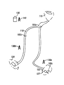
[007] FIG. 1 illustrates an example layout of an open pit mining
environment with a network of haul truck roads.
[008] FIG. 2 is a flowchart illustrating a method for detecting slip events
in
an example embodiment of the present system and method.
[009] FIG. 3 is an example diagram showing a vehicle and system
components enabling determination of the vehicle's heading vector.
[0010] FIG. 4 is
a figure illustrating how a trajectory vector of a vehicle
may be determined using positional data from sensors in an embodiment.
[0011] FIG. 5
illustrates an example of how heading and trajectory vectors
of a vehicle can deviate during vehicle operation.
[0012] FIG. 6 is
a diagram depicting an example of how heading and
trajectory vectors may diverge in an example slip event.
[0013] FIG. 7 is
a graphical representation of how angular deviation may
be compared with alarm thresholds in an example embodiment of this invention.
[0014] FIG. 8 is
a schematic diagram of an example open pit mining
environment with a network of haul truck roads and that illustrates how the
invention could be used to mark problematic areas.
[0015] FIG. 9 is
a flowchart depicting a method for slip detection in
accordance with the present disclosure.
DETAILED DESCRIPTION OF THE INVENTION
[0016] Mine haul
trucks are massive vehicles capable of transporting
hundreds of tons of rock, ore, and other material throughout a mining
facility. The
incredible size of these vehicles and weight of their payloads can limit their
maneuverability, acceleration and deceleration, and sight lines of the area
around the vehicle. A haul truck is operated along specially built roads
within the
mining facility. These roads may not be permanent fixtures and are generally
not
built to highway standards. As such, the roads are subject to new or alternate
routing and continual maintenance or modification as needed to facilitate
mining
operations. The transport of material within the mining environment is often a
rate
3
Date Recue/Date Received 2022-09-21
CA 03044078 2019-05-15
WO 2018/156719
PCT/US2018/019160
limiting step, and therefore haul truck efficiency is a premium. Large turning
radii
and slow braking capabilities due to the sheer size of these vehicles makes
maneuvering along haul roads relatively difficult. Any delays due to
suboptimal
vehicle operations, vehicle or road maintenance, or repairing vehicle damage
can
cause appreciable cost increases. Preventing incidents where control of the
vehicle may become compromised, such as the loss of traction or stability
experienced in slip events, is therefore of utmost importance.
[0017] In various
cases, a cause of a slip event could be related to
construction features of the haul road, such as gradation, incline, curvature,
or
other parameters. Weather conditions, haul truck characteristics such as size
or
tire condition, or operator abilities could also play a role in causing slip
events. It
is therefore important to determine which vehicles are experiencing slip
events
and where and when they are occurring in the mining facility. With this
information it may be possible to troubleshoot the root cause of these events.
[0018] FIG. 1 is
an illustration of an open pit mining environment where the
systems and methods according to embodiments described herewith may be
implemented. In the environment of FIG. 1, a plurality of mine haul trucks
105a-c
operate on a mine haul route network 110. Mine haul trucks 105a-c perform
hauling tasks, for example, by moving material between a shovel site 125, a
crusher site 120 and a dump or stockpile site 115. The haul route as depicted
in
FIG. 1 is an example of possible road networks built within the mining
facility.
Building surface mine haul roads may take into account aspects of highway
engineering, such as sloped inclines, banked curves, adequate drainage, and
road gradation. In practice, these roads are often crude, by highway
standards,
due to the nature of the mine environment and operations. As the mine
excavates earth, the depth and breadth of the mine itself grows. Haul routes
must therefore grow with the mine. This means haul truck roads are evolving
and
changing as needed to facilitate the transport of material around the mine,
necessitating constant monitoring for maintenance and safety considerations.
[0019] Each mine
haul truck 105a-c is equipped with an array of
navigation, communication, and data gathering equipment that assist the haul
4
Date Recue/Date Received 2022-09-21
CA 03044078 2019-05-15
WO 2018/156719
PCT/US2018/019160
truck's operator. Each mine haul truck is equipped with a mobile computing
device, for example, a tablet personal computer, a personal digital assistant,
or a
"smart phone" that may be used to implement the present system. The mobile
computing device includes the basic functionality common to all computing
devices, specifically, data processing, storage, input and output devices like
displays, speakers and either dedicated or on-screen keyboards, and network
communications interfaces. Mine haul trucks are also equipped with antennas or
similar sensor equipment configured to share data with Global Positioning
System (GPS) receivers for the purpose of gathering information about the time-
varying position of the truck. Additionally, or alternatively, these antenna
or
similar devices may communicate with geolocation receivers located
terrestrially
within the mining environment. The position data and other information from
the
GPS and/or geolocating receivers may be shared with a computing device
onboard the vehicle, as well as a mine-wide communications network 130a,
130b, 140 that communicates with other vehicles 105a-c or structures 135
within
the mining facility, such as can be seen in the example in FIG. 1. These GPS
and
geolocating components form the backbone of the vehicle positioning system.
[0020] Through
accurate monitoring of vehicle dynamics during normal
operation within the mine environment, the loss of productivity from slip
events
may be mitigated. One example of this uses GPS or other geolocation
technology to track the location and movements of haul trucks along the roads.
[0021] FIG. 2
shows a flowchart illustrating the generalized steps in an
example implementation 200 of this solution. In step 202, a vehicle
positioning
system uses antennas or similar sensors to send information about their
location
to a receiver or controller that determines the vehicle's position.
Embodiments of
the invention provide for using GPS or other geolocation technology to monitor
the position of haul trucks during operation at the mining facility.
Specifically,
embodiments of the invention use multiple location sensors mounted to the
vehicle to provide multiple data points about vehicle position. The multiple
sensors are each configured to continuously stream data about their own
respective locations within the mine environment. Since the data is
continually
Date Recue/Date Received 2022-09-21
CA 03044078 2019-05-15
WO 2018/156719
PCT/US2018/019160
streaming it is possible to determine where and how the sensor locations are
changing over time. Because the sensors are mounted in known positions on the
haul trucks, the location and orientation of the truck can thereby be
computed.
[0022] In step
204, after the vehicle position data is captured, the heading
and trajectory of the vehicle are determined using the vehicle position data
received in step 202. For example, FIG. 3 depicts a vehicle configuration in
which
two location sensors 304 and 306 are mounted. Each of location sensors 304
and 306 is configured to determine its own location within the mining
environment and provide that location data to controller 314, which may be
mounted within vehicle 300. Because the location of each of location sensors
304 and 306 are known, the location data generated by each sensor can be used
to determine a corresponding position and orientation of vehicle 300 as it
changes over time. For example, sensor 304 has a known centerline offset
(arrow 351) from centerline 308 of vehicle 300. Additionally, sensor 304 has a
known geometrical offset (determined by arrows 351 and 351) from a center of
rotation of vehicle 300, which in this example equates to a center of a rear
axle of
vehicle 300 (indicated by point 353). Similarly, sensor 306 has a known
centerline offset (arrow 354) from centerline 308 of vehicle 300.
Additionally,
sensor 306 has a known geometrical offset (determined by arrows 354 and 355)
from a center of rotation of vehicle 300, which in this example equates to a
center
of a rear axle of vehicle 300 (indicated by point 353).Different vehicles may
have
different centers of rotation. As discussed above, the center of rotation of
some
vehicles may occur at the center of the vehicle's rear axle. In other
vehicles,
however, (e.g., articulated trucks, small trucks) the center of rotation may
be in a
different location. In general, the center or rotation for a particular
vehicle will be
a point occurring along the center of the vehicle's axis of rotation. The axis
of
rotation for a vehicle undertaking a constant-radius turn is both
perpendicular to
the length of the vehicle and in-line with a center point of the circle
defined by the
vehicle's circular constant-radius turn. Typically, the center of rotation is
defined
as a point on the vehicle's axis of rotation located towards a center of the
vehicle
(e.g., a point also occurring on line 308 of FIG. 3).
6
Date Recue/Date Received 2022-09-21
CA 03044078 2019-05-15
WO 2018/156719
PCT/US2018/019160
[0023] FIG. 3
generally illustrates a system configured to determine a
heading of vehicle 300 from data captured from GPS or geolocation sensors 304,
306 located at the front 301 and rear 302, respectively, of the vehicle 300.
[0024] In this
example, the vehicle heading is the direction the front 301 of
the vehicle is facing; i.e.: it is the direction the longitudinal axis 308 of
vehicle 300
is pointing. In this example illustration, the vehicle heading is due east,
according
to compass rose 312. In this system, the known configuration of the position
of
sensors 304 and 306 on the vehicle (by virtue of known geometrical offsets
from
centerline 308 and center of rotation 353 indicated by combinations of arrows
351, 352, 354. and 355) is used to determine the heading, or direction the
nose
of vehicle 300 is pointing. In one embodiment, the heading is computed by
calculating a vector formed between sensors 304 and 306 of vehicle 300. The
system controller determines the geospatial location of each of the sensors
(and
therefore, the corresponding location of vehicle 300) at a particular time and
computes the straight-line axis 310 between them. Using the known locations of
the sensors, the geospatial direction of the straight-line axis 310 between
them
can be determined. Because the position of the sensors on the vehicle is
known,
the relationship between the straight-line axis 310 formed by the line between
the
sensors and the longitudinal axis 308 of the vehicle can be computed by the
system controller 314. The geospatial direction of the longitudinal axis 308,
the
vehicle heading, can then be expressed in nomenclature such as the cardinal
directions (North, South, East, West), degrees of a circle, or another chosen
navigational system. In the example illustrated in FIG. 3, the straight-line
axis 310
between the sensors is parallel to the longitudinal axis 308 of the vehicle.
This
relative relationship may change based on vehicle geometry or sensor mounting
locations.
[0025] The
trajectory of the vehicle is the vector corresponding to the
direction of travel of vehicle 300. In one embodiment, the trajectory is
determined
using the sensor locations and how they are moving in space (e.g., within the
mining environment) over time. The system controller records a sequence of
positional data points from the GPS or geolocation sensors located on the
7
Date Recue/Date Received 2022-09-21
CA 03044078 2019-05-15
WO 2018/156719
PCT/US2018/019160
vehicle. An example of this process for a single sensor is illustrated in FIG.
4. At
each particular time, the controller records the location 401-405 of a sensor
(e.g.,
one of sensors 304 or 306 depicted in FIG. 3) at particular moments of time.
Each incrementally recorded positional data point is used to create a sequence
of positions that represents the path 406 of the sensor over time. The
positional
data points represent discrete moments in time, and therefore the actual path
of
movement is discontinuous. An algorithmic method may use the sequence of
positions to approximate the pathway between individual positional data points
and determine the trajectory 408 of the sensors. When the sensors are mounted
in known locations on a haul truck (such as in the case of sensors 304 and 306
of FIG. 3), the recorded positional data from the sensors can be used to
determine the location and movement of the haul truck. The system controller
314 or other computational device could therefore be able to determine the
trajectory of the vehicle at given time increments using a differencing
algorithmic
method. One such example of an algorithm is the median filtered differencing
method. Applying the median filtered differencing method to a series of data
points, representing geospatial locations as determined by the aforementioned
sensors, generates a trajectory vector for the sensor movement. From this
trajectory determination and the known configuration of sensor positions
relative
to the truck, the controller is able to determine a linear vector
corresponding to
the truck trajectory. In one example implementation, this trajectory vector
could
be defined to lie tangent to the path of the center of the vehicle's rear
axle, i.e.:
the center of the vehicle's rear axle could be defined within the system to
represent the vehicle as a whole. This may be beneficial as the center of the
vehicle's rear axle may be equivalent to a center of rotation of the vehicle
as the
vehicle undergoes a turn. By using the center of the rear axle (and,
specifically,
the center of rotation of the vehicle) as the location of the vehicle, during
a
normal turning activity (i.e., with no excessive sliding) the vehicle's
heading and
trajectory vectors will be parallel to one another at all times.
[0026] These two
vectors, vehicle heading and trajectory, are not always
aligned during operation of the vehicles, and in such cases it can mean the
8
Date Recue/Date Received 2022-09-21
CA 03044078 2019-05-15
WO 2018/156719
PCT/US2018/019160
vehicle heading is not aligned with the direction of travel. This misalignment
can
occur during periods of over- or understeer or wheel slip from loss of
traction.
[0027] FIG. 5
shows an example of a vehicle 500 with example heading
502 and trajectory 504 vectors as vehicle 500 travels through a curved section
of
road 506. As depicted in FIG. 5, vehicle 500 is shown in three sequential
instants
in time 510-512 making a right turn through a curved portion of roadway.
Initially
(510) the vehicle approaches the curve from a straight line where the heading
and trajectory are approximately aligned. In the second instance (511) the
vehicle is entering the curve. Here the trajectory 504 of the vehicle shows a
deviation from heading 502. The trajectory vector 504 is pointed nearly
vertical,
while the heading of the vehicle is pointed in the direction of the exit of
the curve.
In the third instance (512) this deviation has grown, and the vehicle appears
to
be leaving the roadway. In this illustration, the vehicle is moving along the
direction 504 despite facing in a direction 502 that deviates from that by
some
degree. A situation such as this can be caused by complex interaction of
vehicle
dynamics, such as centripetal force, friction force of the tires with the
road, and
factors such as the center of mass or weight distribution of the vehicle,
roadway
conditions, or other factors. In extreme cases, the operator may temporarily
lose
control of the vehicle.
[0028] In one
embodiment of this invention it is possible to detect these
misalignments during vehicle operation by computing the difference in heading
and trajectory. Returning to FIG. 2, in step 206, of implementation 200,
therefore,
the angular difference, or difference signal, between the heading and
trajectory of
the vehicle is determined by the controller (e.g., controller 314 of FIG. 3).
This
difference is calculated as the absolute angle deviation between the two
vectors
as determined by the positioning system sensors. The controller continually
monitors the difference angle between vectors and uses the value of this
angular
deviation, the difference signal, to detect slip events or other changes in
vehicle
dynamics. In some instances, it may be necessary to apply a smoothing
algorithm to the difference signal. This may be the case if the quality of the
heading or trajectory data is compromised, such as if there are interruptions
in
9
Date Recue/Date Received 2022-09-21
CA 03044078 2019-05-15
WO 2018/156719
PCT/US2018/019160
data transmission or other errors that may induce noise to the calculation of
the
difference signal. This smoothing algorithm, such as exponential smoothing,
may
not materially change the result of the difference signal, but could remove
any
spurious measurements from imprecise data. The difference signal, which
represents the angular deviation in the heading and trajectory vectors, could
be
displayed or plotted in a number of ways for tracking and monitoring purposes.
[0029] In one
example, once both the heading and trajectory for a haul
truck are determined, it may be possible to use these values to monitor
vehicle
dynamics and create alerts for possible slip event conditions. FIG. 6 is an
example illustration of a mining haul truck travelling on a route through the
mine.
As the truck 601 approaches the sharp curve, the trajectory vector 602
deviates
from the heading vector 604. The deviation between these two vectors is
greatest during the sharpest section of the curve in the road 606. This
indicates
that the truck 601 is moving almost parallel with the horizontal axis of the
figure,
though the orientation of the vehicle is approximately 45 from the
horizontal.
This large deviation could indicate a slip event, or oversteer. FIG. 6 is an
example diagram of a sequence of events that could be displayed as a motion
picture or graphic on a computer screen or other device for the vehicle driver
or
other mine personnel to monitor the relative movements of these axes for
safety
purposes.
[0030] FIG. 7 is
a graph that depicts the difference between a vehicle's
trajectory and heading over time. The difference signal 702 in this figure is
plotted as a line graph with time 704 as the x-axis and angular deviation 706,
measured in degrees on the y-axis. This figure illustrates an example data set
of
what it may look like if a haul truck moving along a mine route experienced a
slip
event. The dashed lines 708 represent a deviation of 5 degrees in either
direction. If the angular deviation between heading and trajectory exceed 5
degrees, the data will cross this dashed line, as can be seen in 710.
Potential
slip-event criteria based on a variety of parameters such as weather
conditions,
driver behavior, location within the mine, or other relevant factors that may
affect
vehicle dynamics can be used to determine if conditions exist that may make a
Date Recue/Date Received 2022-09-21
CA 03044078 2019-05-15
WO 2018/156719
PCT/US2018/019160
slip event more probable. A more or less strict operating range for the
difference
signal may be chosen to reflect the relevant criteria to monitor for slip
events.
This operating range could be specified, for example, by the dashed lines 708
representing a 5 degree deviation. At 710, there is a large deviation between
the
heading and trajectory vectors of over 40 degrees. This means the direction of
travel of the vehicle differs from the direction the vehicle is pointing by an
amount
that is beyond the operating range of plus or minus 5 degrees. By looking at
the
x-axis 704, it is possible to determine how long the difference signal was
outside
the operating range. The magnitude of this deviation indicates that the
vehicle
may have experienced a slip event, such as a loss of traction, over- or
understeer while travelling along the mine route.
[0031] The
criteria indicated by dashed lines 708 shown here are an
example threshold. This criteria could be varied depending on a number of
factors, at the discretion of mine personnel or others with the proper
authority.
Some factors that may affect the thresholds could be weather or road
conditions
within the mine, driver experience, truck specifications such as size and
weight,
road or truck maintenance schedules, historical slip event data, or other
factors
determined relevant.
[0032] When the
threshold is crossed such a condition may trigger an
alarm. Referring back to FIG. 2, in step 208, if the criteria or threshold
have been
met or exceed, the controller (e.g., controller 314) may take any appropriate
action, including, for example, activating an alarm. Such action may include,
for
example, controller 314 activating or modulating an output of a user interface
315, which may include a light, display screen, or speaker. In an embodiment,
the alarm may include a flashing light, to warn relevant parties, such as a
driver
(if the flashing light or other alarm is generated inside the cab of the
vehicle) or
drivers of other nearby vehicle (if the flashing light or other alarm is
generated
outside the cab of the vehicle) about the slip event. This could include the
truck
driver, mine supervisor(s), or other vehicle drivers. The difference signal
threshold may vary based on various operating conditions, becoming stricter
during periods where slide events may become more likely or potentially have
11
Date Recue/Date Received 2022-09-21
CA 03044078 2019-05-15
WO 2018/156719
PCT/US2018/019160
more significant consequences, such as inclement weather. The criteria for
triggering the alarm may vary as well, such as the duration of time the
difference
signal is outside the threshold. The alarm is cleared once the difference
signal
returns to a value within the operating range as determined by the criteria.
The
alarm, once triggered, may be a flashing light, noise, vibration, or other
signal
that serves to provide an alert about the difference signal being outside the
threshold. The alarm may alert the driver within the cab of the vehicle, other
haul
truck drivers, supervisors, or any other people concerned with the operation
of
haul truck vehicles.
[0033] In one
embodiment, the controller 314 may log incidents that trigger
the alarm, including such parameters as vehicle location within the mining
facility,
heading and trajectory information, duration of alarm-triggering events,
weather
conditions, vehicle identification or other information deemed relevant. For
example, with reference to FIG. 3, controller 314 may utilize a wireless
communication system 316 (e.g., wifi or other IEEE 802.11 communication
protocol, cellular, and the like) to transmit wireless data to a central mine
dispatch system, where the data describes attributes of the detected slide
event.
In an example embodiment, this information may be used to create a database of
information regarding slip events. This information could then be used to map
problem areas on roads within the mining facilities or detect patterns of slip
events with certain vehicles or driving behaviors. FIG. 8 shows an example map
of the mine. Using historical data about slip events from the database,
potential
areas 802 where probability of an incident may occur could be marked on the
map. This information about past slip events could be used for predictive
modelling of slip events or as a warning for precaution to be taken when
operating a haul truck in and around these areas. The database of slip events,
which could include other information collected during historical slip events,
could
also be used for trouble shooting the root cause of these slip events. The
information could be used for pattern recognition related to mine locations,
driver
or vehicle identification, weather, maintenance status, or other patterns that
may
contribute to increased risk of slip events.
12
Date Recue/Date Received 2022-09-21
CA 03044078 2019-05-15
WO 2018/156719
PCT/US2018/019160
[0034] FIG. 9 is
a flowchart depicting a method for slip detection in
accordance with the present disclosure. The steps depicted in FIG. 9 may be
implemented, for example, by controller 314 of vehicle 300 depicted in FIG. 3
in
combination with the other system components depicted in FIG. 3. As such,
method 900 is described in combination with references to the example system
components depicted in FIG. 3.
[0035] In step
902, location data is received from both a first location
sensor (i.e., sensor 306) and a second location sensor (i.e., sensor 304).
Each
sensor is mounted to the vehicle is a known location with respect to a center
of
rotation (i.e., point 353) of the vehicle, which may typically be a center of
a rear
axle of the vehicle.
[0036] In some
embodiments, because the location data generated by
each of the two sensors can be noisy, the location data received in step 902
may, to some degree, by smoothed by averaging out several points to come up
with a more stable and reasonable location data over time. This filtering or
smoothing could be done several ways, such as by filtering the location data
generated by each sensor using a Kalman filter.
[0037] In step
904, a heading of the vehicle is determined. As described
above, the heading refers to the direction in which the front of the vehicle
is
pointing and, in the case of a slide, may not correlate to the direction of
actual
travel of the vehicle. Both sensor 304 and sensor 306 have a known distance
(indicated by arrows 351 and 354, respectively) from centerline 308 of vehicle
300. In this example, the centerline offsets of both sensors are the same.
And, as
such, the heading of vehicle 300 can be determined by mapping a vector (e.g.,
arrow 310) from the position of rear location sensor 306 to the position of
front
location sensor 304. Because each location sensor is the same distance from
the
vehicle's centerline, a vector drawn from the position of the rear location
sensor
to the front location sensor will run parallel to the vehicle's centerline and
can
therefore correctly indicate the heading (i.e., measured in degrees) of
vehicle
300.
13
Date Recue/Date Received 2022-09-21
CA 03044078 2019-05-15
WO 2018/156719
PCT/US2018/019160
[0038] In other
embodiments, the location sensors may not each be the
same distance from the vehicle's centerline. In that case, to determine the
vehicle's heading, a vector can be drawn between the locations of the location
sensors and then the orientation vector can be adjusted based upon the
relative
positioning of the vehicle's location sensors to determine an accurate heading
for
the vehicle.
[0039] Having
determined the heading of the vehicle, in step 906 the
bearing of vehicle 300 is determined. As described herein, the vehicle's
bearing
describes the direction the vehicle is moving which, during a slide event, may
not
be the same as the vehicle's heading. In general, the vehicle's bearing is
determined by determining how the vehicle is moving through space over time
and, specifically, how the vehicle's location sensors in space (e.g., within
the
mining environment) move over time. Generally, controller 314 determines a
sequence of positional data points for the vehicle over time, where the
positional
data points represent discrete moments in time, and therefore the actual path
of
movement is discontinuous. An algorithmic method may use the sequence of
positions of the vehicle to determine the bearing of the vehicle.
[0040] In a
specific embodiment, to determine the vehicle's bearing,
controller 314 determines the path taken by a center of rotation of the
vehicle
over time. Specifically, in the present example, the center of rotation of
vehicle
300 equates to the center of the vehicle's rear axle, or point 353. In order
to
determine the location of point 353, controller 314 utilizes the location data
provided by one or both sensors 304 and 306.
[0041] To
determine a location of the vehicle's center of rotation using
location data received from sensor 306, controller 314 translates the location
received from sensor 306 along arrow 354 in a direction perpendicular to arrow
310 (which was previously established in step 904) to the center line 308 of
vehicle 300 and then along arrow 355 to point 353. Because the lengths of
arrows 354 and 355 are known (due to the known placement of sensor 306 on
vehicle 300), this enables controller to determine a location of the center of
rotation of vehicle 300 using the location data received from sensor 306. In a
14
Date Recue/Date Received 2022-09-21
CA 03044078 2019-05-15
WO 2018/156719
PCT/US2018/019160
similar manner, to determine a location of the vehicle's center of rotation
using
location data received from sensor 304, controller 314 translates the location
received from sensor 304 along arrow 351 in a direction perpendicular to arrow
310 to the center line 308 of vehicle 300 and then along arrow 352 to point
353.
Because the lengths of arrows 351 and 352 are known (due to the known
placement of sensor 304 on vehicle 300), this enables controller to determine
a
location of the center of rotation of vehicle 300 using the location data
received
from sensor 304.
[0042] If
controller 314 uses the location data from both sensors 304 and
306 to determine the location of the vehicle's center of rotation at a
particular
point in time, the two determined center of rotation locations (derived from
the
location data of the two different sensors) may be combined (e.g., averaged)
to
determine a single location for the vehicle's center of rotation at that point
in time.
In other embodiments, controller 314 may only use data captured from a single
one of sensors 304 and 306 to determine a location of the vehicle's center of
rotation.
[0043] Using this
approach, the location of the vehicle (and, specifically,
the location of the vehicle's center of rotation) can be determined over time
using
data generated by one or more of sensors 304 and 306 to generate a sequence
of locations reflective of the actual movement of the vehicle 300. Then, using
techniques described herein (e.g., mapping a vector from one of the locations
to
the next determined location in time) a bearing for the vehicle can be
determined.
[0044] In step
908, with both the heading and bearing of the vehicle
determined, controller 314 determines an angular difference between the
determined heading and bearing. In step 910, controller 314 determines an
angular difference threshold. As described herein, the angular difference
threshold may be a fixed value (e.g., 5 or 10 degrees). In other embodiments,
the
threshold may be at least partially determined by a number of factors. For
example, the vehicle's current speed may be used to scale the threshold
determined by controller 314. When using the vehicle's speed, the threshold
may
be increased (requiring a greater deviation between heading and bearing to
Date Recue/Date Received 2022-09-21
CA 03044078 2019-05-15
WO 2018/156719
PCT/US2018/019160
trigger slide detection) at lower speeds where the heading and bearing data
may
be less reliable and where slides are less likely. Conversely, the threshold
may
be decreased (requiring a smaller deviation between heading and bearing to
trigger slide detection) at higher speeds where the heading and bearing data
may
be more reliable and where slides are more likely. In that case, the speed of
vehicle may be used as a scaling factor in adjust the threshold. In some
cases,
other weighting factors beyond just speed may be utilized to determine the
threshold value. For example, the vehicle's weight, time of day, weather
conditions, and the like, could all be factors used to determine the
applicable
angular difference threshold.
[0045] Having
determined the angular difference threshold, in step 912,
controller 314 determines whether the angular difference between the vehicle's
heading (determined in step 904) and the vehicle's bearing (determined in step
906) exceeds the angular difference threshold. In some embodiment, this
comparison may further include determining whether the angular difference has
exceeded the threshold for a minimum time duration. By requiring that the
deviation exist for some minimum time duration, the likelihood that momentary
inaccurate location data received from one or both of sensors 304 and 306
could
trigger an alarm can be reduced. For example, if the angular difference
between
the vehicle's heading and the vehicle's bearing does not exceed the angular
difference threshold, the method returns to step 902 and repeats so that the
vehicle's bearing and heading can be consistently monitored for slide events.
[0046] But if the
difference exceeds the threshold, in step 914 controller
314 determines that a slide has been detected and signals an alarm. The alarm
may occur within the vehicle (so as to alert the vehicle's operator) such as
by a
suitable user interface (e.g., user interface 315) generating one or more of a
visual, audible, haptic, or other alarm. In some cases, the alarm may also
occur
on the outside of the vehicle (e.g., via the flashing of a light mounted on an
exterior of the vehicle or sounding of a siren) to alert individuals and other
vehicle
operators in the vicinity of the vehicle that the vehicle is undergoing a
slide event.
16
Date Recue/Date Received 2022-09-21
CA 03044078 2019-05-15
WO 2018/156719
PCT/US2018/019160
[0047] In some
embodiments, when a slide event is detected, controller
314 may also transmit data to a central mine dispatch computer system describe
the slide event (e.g., vehicle location, magnitude of slide event, speed of
vehicle
at the time of the event, and the like) via a suitable communications network,
such as wireless communication system 316. As described herein, such data
may enable a centralized computer system to detect regions of the mining
environment in which a relatively large number of vehicles are experiencing
slide
events. Upon detecting such a region, actions can be taken to modify the local
roadway to reduce the likelihood of vehicles experiencing further slide events
in
that region.
[0048] In an
embodiment, a system includes a first location sensor
mounted to a mining haul truck. The first location sensor has a first known
geometrical offset from a center of a rear axle of the mining haul truck. The
system includes a second location sensor mounted to the mining haul truck. The
second location sensor has a second known geometrical offset from the center
of
the rear axle and a third known geometrical offset from the first location
sensor.
The system includes a wireless communication system configured to transmit
data to a central mine dispatch computer system, a display screen, and a
controller in communication with the display screen and the wireless
communication system. The controller is configured to determine a heading of
the mining haul truck by mapping a first vector from a location of the first
location
sensor to a location of the second location sensor, and determine a bearing of
the mining haul truck by determining a first location of the center of the
rear axle
using a first location data from the first location sensor and a second
location
data from the second location sensor, determining a second location of the
center of the rear axle using a third location data from the first location
sensor
and a fourth location data from the second location sensor, and determining
the
bearing of the mining haul truck by mapping a second vector from the first
location of the center of the rear axle to the second location of the center
of the
rear axle. The controller is configured to determine that an angular
difference
between the heading of the mining haul truck and the bearing of the mining
haul
17
Date Recue/Date Received 2022-09-21
CA 03044078 2019-05-15
WO 2018/156719
PCT/US2018/019160
truck exceeds a threshold angular difference indicating a slide event,
generate an
output at the display screen, wherein the output indicates that a slide event
has
occurred, and transmit a broadcast message, using the wireless communication
system, to the central mine dispatch computer system indicating that a slide
event has occurred. The broadcast message identifies a location of the mining
haul truck.
[0049] In an
embodiment, a system includes a first location sensor
mounted to a vehicle, a second location sensor mounted to the vehicle, a user
interface mounted to the vehicle, and a controller in communication with the
user
interface. The controller is configured to determine a heading of the vehicle
using
a first location data from the first location sensor and a second location
data from
the second location sensor, determine a bearing of the vehicle using at least
one
of the first location data from the first location sensor and the second
location
data from the second location sensor, determine that an angular difference
between the heading and the bearing of the vehicle exceeds a threshold angular
difference, and generate an output at the user interface, wherein the output
indicates that a slide event has occurred.
[0050] In an
embodiment, a method includes determining a heading of a
vehicle using a first location data from a first location sensor mounted to
the
vehicle and a second location data from a second location sensor mounted to
the
vehicle, determining a bearing of the vehicle using at least one of the first
location data from the first location sensor and the second location data from
the
second location sensor, determining that an angular difference between the
heading and the bearing exceeds a threshold angular difference, and generating
an output at a user interface mounted to the vehicle, wherein the output
indicates
that a slide event has occurred.
[0051] Some of
the functional units described in this specification have
been labeled as modules in order to more particularly emphasize their
implementation independence. For example, a module may be implemented as a
hardware circuit comprising custom VLSI circuits or gate arrays, off-the-shelf
semiconductors such as logic chips, transistors, or other discrete components.
A
18
Date Recue/Date Received 2022-09-21
CA 03044078 2019-05-15
WO 2018/156719
PCT/US2018/019160
module may also be implemented in programmable hardware devices such as
field programmable gate arrays, programmable array logic, programmable logic
devices, or the like.
[0052] Modules
may also be implemented in software for execution by
various types of processors. An identified module of executable code may, for
example, comprise one or more physical or logical blocks of computer
instructions which may, for example, be organized as an object, procedure, or
function. Nevertheless, the executables of an identified module need not be
physically located together, but may comprise disparate instructions stored in
different locations which, when joined logically together, comprise the module
and achieve the stated purpose for the module.
[0053] Indeed, a
module of executable code may be a single instruction, or
many instructions, and may even be distributed over several different code
segments, among different programs, and across several memory devices.
Similarly, operational data may be identified and illustrated herein within
modules, and may be embodied in any suitable form and organized within any
suitable type of data structure. The operational data may be collected as a
single
data set, or may be distributed over different locations including over
different
storage devices, and may exist, at least partially, merely as electronic
signals on
a system or network.
[0054] The
schematic flow chart diagrams included are generally set forth
as logical flow chart diagrams. As such, the depicted order and labeled steps
are
indicative of one embodiment of the presented method. Other steps and methods
may be conceived that are equivalent in function, logic, or effect to one or
more
steps, or portions thereof, of the illustrated method. Additionally, the
format and
symbols employed are provided to explain the logical steps of the method and
are understood not to limit the scope of the method. Although various arrow
types and line types may be employed in the flow chart diagrams, they are
understood not to limit the scope of the corresponding method. Indeed, some
arrows or other connectors may be used to indicate only the logical flow of
the
method. For instance, an arrow may indicate a waiting or monitoring period of
19
Date Recue/Date Received 2022-09-21
CA 03044078 2019-05-15
WO 2018/156719
PCT/US2018/019160
unspecified duration between enumerated steps of the depicted method.
Additionally, the order in which a particular method occurs may or may not
strictly
adhere to the order of the corresponding steps shown.
[0055]
Furthermore, the described features, structures, or characteristics
of the invention may be combined in any suitable manner in one or more
embodiments. In the following description, numerous specific details are
provided, such as examples of programming, software modules, user selections,
network transactions, database queries, database structures, hardware modules,
hardware circuits, hardware chips, etc., to provide a thorough understanding
of
embodiments of the invention. One skilled in the relevant art will recognize,
however, that the invention may be practiced without one or more of the
specific
details, or with other methods, components, materials, and so forth. In other
instances, well-known structures, materials, or operations are not shown or
described in detail to avoid obscuring aspects of the invention.
[0056] This
invention is described in preferred embodiments in the
following description with reference to the Figures, in which like numbers
represent the same or similar elements. Reference throughout this
specification
to "one embodiment' "an embodiment," or similar language means that a
particular feature, structure, or characteristic described in connection with
the
embodiment is included in at least one embodiment of the present invention.
Thus, appearances of the phrases "in one embodiment," "in an embodiment,"
and similar language throughout this specification may, but do not
necessarily, all
refer to the same embodiment.
[0057] Where,
"data storage media," or "computer readable media" is
used, Applicants mean an information storage medium in combination with the
hardware, firmware, and/or software, needed to write information to, and read
information from, that information storage medium. In certain embodiments, the
information storage medium comprises a magnetic information storage medium,
such as and without limitation, a magnetic disk, magnetic tape, and the like.
In
certain embodiments, the information storage medium comprises an optical
information storage medium, such as and without limitation, a CD, DVD (Digital
Date Recue/Date Received 2022-09-21
CA 03044078 2019-05-15
WO 2018/156719
PCT/US2018/019160
Versatile Disk), HD-DVD (High Definition DVD), BD (Blue-Ray Disk) and the
like.
In certain embodiments, the information storage medium comprises an electronic
information storage medium, such as and without limitation, a PROM, EPROM,
EEPROM, Flash PROM, compactflash, smartmedia, and the like. In certain
embodiments, the information storage medium comprises a holographic
information storage medium.
[0058] Reference
is made throughout this specification to "signals."
Signals can be any time varying electromagnetic waveform, whether or not
encoded with recoverable information. Signals, within the scope of this
specification, can be modulated, or not, according to any modulation or
encoding
scheme. Additionally, any Fourier component of a signal, or combination of
Fourier components, should be considered itself a signal as that term is used
throughout this specification.
[0059] While one
or more embodiments of the present invention have
been illustrated in detail, the skilled artisan will appreciate that
modifications and
adaptations to those embodiments may be made without departing from the
scope of the present invention as set forth in the following claims.
21
Date Recue/Date Received 2022-09-21