Note: Descriptions are shown in the official language in which they were submitted.
A REAL-TIME DYNAMIC LINE RATING (RLR) MONITORING SYSTEM
AND METHOD THEREFOR
FIELD OF THE DISCLOSURE
The present disclosure relates generally to real-time sensing-analysis systems
and
methods, and, to systems and methods for analyzing the active varying of
presumed
thermal capacity for overhead power lines in response to transmission
throughput,
environmental and weather conditions. This is done continually in real-time,
based on
changes in powerline conductor ground clearance continuous monitoring, which
considers
the factors of transmission line throughput, ambient temperature, solar
radiation, wind
speed and wind direction, with the aim of regulation compliance, maximizing
transmission
line throughput, while minimizing grid congestion.
BACKGROUND
The power transmission industry commonly has a need to monitor and assess
transmission line Dynamic Line Rating (RLR), for regulation compliance,
safety, and
production management. Ampacity of an overhead transmission line is the
maximum
electrical current that the transmission line can carry under ideal external
conditions
without reducing the tensile strength of the conductor or exceeding the
maximum sag
beyond which minimum electrical clearance requirements to ground and to
objects. To
ensure that the tensile strength or the clearance requirements of a
transmission lines are
not exceeded under time-varying external conditions, transmission lines are
given line
ratings that determine their maximum power carrying capacities. The line
rating of a
transmission line is determined by the strength of the current flowing through
it, conductor
size and resistance, conductor clearance to ground, and ambient weather
conditions of
temperature, wind speed and direction, and solar radiation. The current-
carrying capacity
of a transmission line is influenced by line heating and cooling. When current
flows
through a transmission line, the transmission line heats up, it expands and
sags, and its
clearance from the ground and/or other conductors decreases. All transmission
lines have
a sagging limit, and sags beyond this limit are dangerous for public safety.
Multiple
atmospheric conditions can affect line sag significantly, particularly
temperatures, solar
radiation, wind speed, wind directions. The industry often uses multiple
factor
1
Date Regue/Date Received 2022-10-12
measurement to estimate the impact of the ambient weather conditions and
adjust the DLR
of the transmission lines. However, all estimate method have limits due to the
complex
and unpredictable nature of the weather condition changes, combing with the
variations of
the production throughput of the lines, the rating methods all lack in real-
time monitoring
capability and the level of accuracy required to maximize transmission
production. As a
result, the industry is suffering losses of production due to large margins of
safety factors
and have missed out the benefit of maximizing transmission line throughput,
while
minimizing grid congestion.
SUMMARY
According to one aspect of this disclosure, there is provided a ground
clearance-
based power line dynamic line rating and monitoring system. The dynamic
monitoring
system comprises: an array of remote sensing nodes for detecting conductor
ground
clearance digital signals; a wired or wireless network system to communicate
the nodal
digital signals; a data-processing software computing module located locally
or remotely;
a database server or cloud storage, and an access interface for local and
remote viewing,
data analysis, and remote control.
BRIEF DESCRIPTION OF THE DRAWINGS
FIG. 1 is a schematic diagram of a communication system network, according to
some embodiments of the present disclosure;
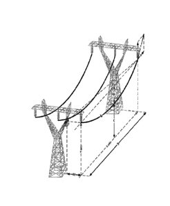
FIG. 2 shows a sensing arrangement to identify powerline sag;
FIG. 3 shows an illustration of power line sag monitoring display
DE TAILED DESCRIPTION
Embodiments herein disclose a real-time Dynamic Line Rating (RLR) system
having one or more server computers, one or more client-computing devices, and
one or
more remote sensing detection units, all functionally connected via a network.
The one or
more remote sensing detection units may be deployed in a site for conductor
ground
clearance measurement. The monitoring data are sent to the one or more server
computers
for vibration analysis.
In some embodiments, the remote real-time monitoring system also comprises one
or more data hubs, each functionally coupled to one or more field detection
units. The data
2
Date Regue/Date Received 2022-10-12
hub collects vibration data from the vibration-detection units and transmits
the collected
data to the server computer.
In some embodiments, each vibration-detection unit node comprises a field
sensor,
a communication module as shown in FIG.1, and a positioning module such as a
Global
Positioning System (GPS) module for automatically determining the position or
geolocation of the field detection unit, thereby avoiding the manual recording
and/or
updating of the geolocations of the vibration-detection units during their
deployment and
re-deployment. The GPS also provide time information for data time stamping.
The signal
time stamp from multiple sensors in the network is then used to calculation
locations of
the concerned events.
In some embodiments, the signal-processing module may be implemented as a
report by exception digital filter. In some other embodiments, the signal-
processing
module may be implemented as a signal-processing firmware or software program
acting
as a digital filter. The digital filter or the signal-processing program may
be implemented
in the field detection unit, in the data hub, and/or in the server computer.
The field detection units may be deployed in the site individually or in an
independent array arrangement. Each field detection unit may operate
independently
within an independent array arrangement. In various embodiments, the field
detection
units may be field-operated or remotely-controlled to continuously or
intermittently collect,
store, and transmit vibration data to the server computer for automatic data
processing,
recognition, and generate visualization with an integrated map interface. Real-
time field
detection units measure multiple attributes of the transmission line field
data, including
magnetic field data, electrical field data, ambient temperature data, wind
speed/direction
data, support structure and ground vibration data. The data transmission is
used for real-
time analysis to calculate the powerline distance to the ground.
In some embodiments, the field detection units are positioned directly under
the
power line to detect magnetic field and electric field signal strength. An
example is
illustrated in FIG. 2, where the detected signal strength is calculated,
translated into
distance information and displayed remotely over the network for real-time
monitoring.
The computer system network can compare the ground clearance distance
information to
the system threshold, a warning signal or a control signal can be generated to
trigger
system protection and mitigation measures.
In some embodiments, the field detection units are mounted along the power
line
3
Date Regue/Date Received 2022-10-12
and support structures to detect line sag movement, line angles and changes.
The
information can be combined to confirm the line sag status with enhanced
accuracy.
In some embodiments, the field detection unit includes an inductance unit to
harvest energy from the electric and magnetic field, and convert the energy
into operating
power for sensing and data transmission.
FIG. 1 is a schematic diagram of a communication system network, according to
some embodiments of the present disclosure. The networking interface comprises
one or
more networking modules for connecting to other computing devices or networks
through
the network by using suitable wired or wireless communication technologies
such as
Ethernet, WI-Fl , (WI-Fl is a registered trademark of the City of Atlanta DBA
Hartsfield-
Jackson Atlanta International Airport Municipal Corp., Atlanta, GA, USA),
BLUETOOTH (BLUETOOTH is a registered trademark of Bluetooth Sig Inc.,
Kirkland,
WA, USA), ZIGBEE (ZIGBEE is a registered trademark of ZigBee Alliance Corp.,
San
Ramon, CA, USA), 3G, 4G and 5G wireless mobile telecommunications, other radio
frequency narrowband communications, satellite technologies, and/or the like.
In some
embodiments, parallel ports, serial ports, USB connections, optical
connections, or the like
may also be used for connecting other computing devices or network.
Although embodiments have been described above with reference to the
accompanying drawings, those of skill in the art will appreciate that
variations and
modifications may be made without departing from the scope thereof as defined
by the
appended claims.
4
Date Regue/Date Received 2022-10-12