Note: Descriptions are shown in the official language in which they were submitted.
WO 2022/003343
PCT/GB2021/051647
SYSTEMS AND METHODS FOR INTERACTIVE VEHICLE TRANSPORT NETWORKS
FIELD OF THE INVENTION
[0001] The present invention is concerned with systems and methods for
interactive vehicle transport
networks, such as those involving autonomous vehicles. More particularly
though not exclusively, the
present invention is directed to improvements in or relating to systems and
methods for the operation
of transport networks involving ground-based or airborne vehicles providing
transportation of
passengers or goods within cities, urban areas or along, above or near
designated motorways,
freeways, roads, railways or other routes between cities and urban areas. Any
or all of the vehicles may
be anywhere on the scale from fully autonomous to fully driver/pilot
controlled. Also, they may or may
not be linked to local, regional, or national traffic management systems. Such
interactive systems and
methods can not only track vehicles but can also be involved in corresponding
data management and/or
communications concerning such vehicles.
BACKGROUND OF THE INVENTION
[0002] With ongoing developments in autonomous vehicle operation, there exists
a need to adapt
traffic management systems to take advantage of the new capabilities of
autonomous vehicles. In
particular, as vehicles are increasingly capable of regulating their own
movement, some of the
disadvantages of user operation are removed, such as a driver or pilot's
reaction speeds, concentration
levels, tiredness etc. As a result, autonomous vehicles are more able to react
quickly to environmental
hazards and as a result, higher speeds and higher densities of vehicles are
able to be safely achieved
than when compared to user operated vehicles, where factors such as thinking
distance must be applied
when considering safe stopping distances.
[0003] In order to enable such traffic management, it is necessary for the
vehicles to have access to
accurate kinematic data regarding themselves and each of the vehicles in their
proximity, which enable
appropriate actions to be taken. This will include kinematic data of both a
particular vehicle which is to
take an action, as well as other vehicles in its vicinity which may affect the
decision of which actions
should be taken.
[0004] Current technology architecture relies on the principle that sensors
onboard the vehicles
provide each vehicle independently with its own situational awareness with
which it can then reason
about its environment and make and enact its own decisions.
[0005] Over recent years, commercially available situational sensing and geo-
location technologies
including RADAR (Radio Detection And Ranging), LIDAR (Light Imaging, Detection
& Ranging), GNSS
(Global Navigation Satellite Systems), EO (Electro-Optic) sensors and IR
(Infra-Red) sensors have all
reduced in mass, size, power consumption, heat output and susceptibility to
environmental hazards
such as mechanical shock, vibration and electro-magnetic interference to the
extent that in principle
they can be integrated into commercial vehicles (e.g. buses, trucks, taxis,
drones) and domestic
vehicles (e.g. cars, personal flying vehicles) to work in combination to
provide situational awareness,
potentially enabling driverless or pilotless operation. However, the
complexity of all such approaches to
situational awareness based on multiple sensors and sensor fusion in the
safety critical application of
driverless/pilotless vehicles is considerable. The authors' experience in
defence and aerospace is that
this complexity inevitably drives up vehicle cost and increases safety hazard
risks. Furthermore, it
becomes increasingly difficult to adopt a common approach, such that
standardisation becomes
challenging. Despite the huge investments made by a number of large technology
companies in
driverless cars the past decade has shown extremely slow progress, with safety
hazard risks becoming
increasingly of concern to the extent that the potential for regulatory
approval of driverless vehicles is
1
CA 03182284 2022- 12- 12
WO 2022/003343
PCT/GB2021/051647
brought into question.
[0006] In some known systems, an attempt is made to implement roadside, in
road or above road
sensing equipment to detect, localise, track, and communicate with vehicles
for the purpose of, for
example, traffic flow management. However, typically these systems are unable
to achieve such
detection with the real-time kinematic accuracy and reliability necessary for
safe autonomous navigation
in traffic streams at currently legislated speeds and advisory vehicle
separations, let alone any
increased traffic flow rates.
[0007] Using a representative example of traffic flowing at a typical speed of
100 km/h (28 m/s) on a
motorway or freeway, if the ground truth (i.e. the physical reality) of a
vehicle's longitudinal position is
to be measured every 50cm of travel to an accuracy of 5cm, then the
measurement must be performed
to that accuracy and provided repeatedly with a periodicity of around 20ms,
equivalent to a frequency
of around 50Hz. Existing roadside systems are unable to achieve such accuracy
and frequency.
[0008] It is an object of the present invention to address at least one or
more of the problems described
above.
SUMMARY OF THE INVENTION
[0009] According to a first aspect the present embodiments there is provided a
vehicle tracking device
for tracking one or more vehicles at a geographic location of a transport
network within which the one
or more vehicles are able to move, the vehicle tracking device comprising: one
or more infra-red (IR)
sensors having a field of view and being configured to detect IR radiation
being emitted from or reflected
by the one or more vehicles at the geographic location within the field of
view; a receiver configured to
receive unique identification data which uniquely identifies each of the one
or more vehicles and position
data which indicates an initial position of each of the one or more vehicles
when the one or more
vehicles enter the field of view at the geographic location; a processor
configured to determine current
kinematic data of the one or more vehicles in at least two dimensions based
upon the IR radiation
detected by the one or more IR sensors, the received unique identification
data and the received
position data; and a transmitter configured to transmit the determined current
kinematic data of a
particular vehicle of the one or more vehicles to a kinematic data receiver
spaced apart from the
transmitter.
[0010] In some embodiments, the particular vehicle is a ground-based vehicle.
In such embodiments,
the vehicle tracking device may be provided with terrain mapping data, and the
processor may be
configured to determine current kinematic data in three dimensions based upon
one or more of the
detected IR radiation, the unique identification data, previously-determined
kinematic data of each of
the one or more vehicles and the terrain mapping data. In alternate
embodiments, the particular vehicle
is an airborne vehicle.
[0011] In further embodiments, the one or more vehicles comprises at least two
vehicles and one of
the vehicles is a ground-based vehicle and the other vehicle is an airborne
vehicle, and wherein the
one or more IR sensors comprises at least two sensors, one IR sensor being
configured to detect IR
radiation being emitted from or reflected by the ground-based vehicle and the
other IR sensor being
configured to detect IR radiation being emitted from or reflected by the
airborne vehicle.
[0012] In yet further embodiments, the processor is configured to use
previously determined current
kinematic data of the one or more vehicles as an input to the processor for
determination of the current
kinematic data for each of the one or more corresponding vehicles. In some
embodiments, the
processor is configured to determine current kinematic data of the one or more
vehicles at a frequency
of at least 50Hz.
2
CA 03182284 2022- 12- 12
WO 2022/003343
PCT/GB2021/051647
[0013] In some embodiments, the receiver is additionally configured to receive
data relating to a
ground-space envelope or an air space envelope of the one or more vehicles and
the processor is
arranged to use the ground-space envelope or air space envelope to determine
relative positioning of
the one or more vehicles.
[0014] In some embodiments, the vehicle tracking device further comprises an
IR emitter configured
to emit IR radiation toward the one or more vehicles.
[0015] In further embodiments, the transmitter is configured to transmit the
determined current
kinematic data to a kinematic data receiver of a particular vehicle. In some
embodiments, the transmitter
is configured to transmit the determined current kinematic data of each of the
one or more vehicles to
a respective kinematic data receiver of the one or more vehicles. In alternate
embodiments, the
transmitter is configured to transmit the determined kinematic data to a
kinematic data receiver of a
remotely located Traffic Management System (TMS). In further arrangements of
the above
embodiments, the processor may further configured to generate a control signal
for controlling the
particular vehicle of the one or more vehicles based upon the determined
current kinematic data of the
at least one of the one or more vehicles, wherein the control signal includes
instructions which when
executed by the particular vehicle cause an alteration of a velocity or
position of the particular vehicle,
and where the transmitter is further configured to transmit this control
signal to the particular vehicle.
[0016] In embodiments of this aspect, at least one of the one or more IR
sensors is configured to
detect IR radiation emitted from or reflected by a fixed geographical
reference point, and the processor
is further configured to: determine a position of the vehicle tracking device
with respect to the fixed
geographical reference point; and use the determined position of the vehicle
tracking device when
determining the current kinematic data of the one or more vehicles.
[0017] In further embodiments, the current kinematic data of the one or more
vehicles determined by
the processor, comprises at least a geographic position over time of the
corresponding vehicle. In yet
further embodiments, the vehicle tracking device is configured to monitor an
entry point with a fixed
position, and to receive data relating to the fixed position at a particular
point in time as the initial position
of each of the one or more vehicles. The processor may be further configured
to generate a pull request
to be transmitted by the transmitter which requests the transmission of the
unique identifier data and
initial position data from the one or more vehicles.
[0018] In an additional aspect of the present embodiments, there is further
provided a vehicle tracking
system for tracking one or more vehicles, the vehicle tracking system
comprising a plurality of vehicle
tracking devices as described in any of the arrangements of the first aspect
arranged in a network, and
where the transmitter of a first vehicle tracking device is configured to
transmit the current kinematic
data determined at the first vehicle tracking device and unique identification
data of the one or more
vehicles to a second vehicle tracking device of the plurality of tracking
devices and the receiver of the
first vehicle tracking device is configured to receive current kinematic data
determined at a third vehicle
tracking device of the plurality of vehicle tracking devices and unique
identification data of the one or
more vehicles from a third vehicle tracking device.
[0019] In further embodiments of this aspect, the processor of the second
vehicle tracking device is
further configured to compare current kinematic data of at least one of the
one or more vehicles
determined locally at the second device with current kinematic data received
from and determined at
the first vehicle tracking device to determine an agreement between the
locally determined current
kinematic data and the received kinematic data. In such cases, the second
vehicle tracking device may
receive the results of data comparisons between at least two other vehicle
tracking devices and the
processor of the second tracking device may be configured to use voting to
identify a tracking device
that is behaving inconsistently.
3
CA 03182284 2022- 12- 12
WO 2022/003343
PCT/GB2021/051647
[0020] In yet further embodiments of this aspect, at least two of the
plurality of vehicle tracking devices
are arranged to be located geographically adjacent to each other and the IR
sensors of the adjacently-
located vehicle tracking devices have partially overlapping fields of view.
[0021] In some embodiments of this aspect, the vehicle tracking system further
comprises a remote
communications device comprising a remote data receiver configured to receive
remote data from a
wide area communications network; and a remote data transmitter configured to
transmit the remote
data to one or more of the plurality of vehicle tracking devices; wherein the
one or more of the plurality
of vehicle tracking devices are configured to receive the remote data and to
transmit the received
remote data to at least one of the one or more vehicles. The remote
communications device may be
configured to transmit the received remote data to each of the plurality of
vehicle tracking devices. The
remote communications device may further be configured to transmit the
received remote data to each
of the plurality of vehicle tracking devices in parallel. The current vehicle
tracking device of the plurality
of vehicle tracking devices may further be configured to: receive the remote
data transmitted from the
remote communications device directly or via another one of the plurality of
vehicle tracking devices;
and transmit the received remote data to a further one of the plurality of
vehicle tracking devices.
[0022] In some of the above embodiments, the remote communications device may
be further
configured to receive local data from one or more of the plurality of vehicle
tracking devices and to
transmit the local data to the wide area communications network.
[0023] In yet further arrangements of the above embodiments, a first one of
the plurality of vehicle
tracking devices is configured to transmit the determined current kinematic
data of the vehicle tracking
device to the remote communications device and the remote communications
device is configured to
receive the determined current kinematic data from the first one of the
plurality of vehicle tracking
devices. In such arrangements, a second one of the plurality of vehicle
tracking devices may be
configured to receive the determined current kinematic data from the remote
communications device.
The remote communications device may be further configured to transmit the
determined current
kinematic data, local to the system, to a remotely-located interaction device.
The remote
communications device may be communicably coupled to a Traffic Management
System (TMS) and
may be configured to transmit determined current kinematic data to the TMS.
The remote
communications device may be configured to receive determined current
kinematic data from the TMS.
The remote data receiver may comprise a satellite communications receiver. The
remote data receiver
may comprise a OneWeb satellite communications receiver. The remote data
receiver may comprise a
4G or 5G radio telecommunications receiver. The remote data receiver may
comprise a wired network
communications receiver.
[0024] The remote data may comprise a control signal for controlling a
particular vehicle of the one or
more vehicles based upon the determined current kinematic data of the at least
one of the one or more
vehicles, wherein the control signal includes instructions which when executed
by the particular vehicle
cause an alteration of a velocity or position of the particular vehicle, and
where the transmitter of a
particular vehicle tracking device proximate to the particular vehicle may be
further configured to
transmit the control signal to the particular vehicle.
[0025] In some embodiments, wherein the remote communications device comprises
a plurality of
remote communications devices, each one of the remote communications devices
being positioned in
a location geographically spaced apart from other ones of the plurality of
remote communications
devices and being configured to transmit the remote data to one or more of the
plurality of vehicle
tracking devices provided within a geographical region local to the location.
4
CA 03182284 2022- 12- 12
WO 2022/003343
PCT/GB2021/051647
[0026] In further embodiments of this aspect, the system further comprises a
local communications
device comprising: a local data receiver configured to receive local data from
one or more of the plurality
of vehicle tracking devices; and a local data transmitter configured to
transmit the local data to a
remotely-located device via a wide area communications network, wherein the
one or more of the
plurality of vehicle tracking devices are configured to receive local data
from at least one of the one or
more vehicles and to transmit the received local data to the local
communications device. The local
data may comprise one or more of: vehicle diagnostics and prognostics data,
driver condition data,
driver health data, driver or passenger activity data and vehicle telemetry
data. The local data may
comprise any data whatsoever originating from the vehicle, its contents or
occupants. In some
embodiments, the one or more vehicles are airborne vehicles and a first subset
of the plurality of vehicle
tracking devices are configured to track one or more airborne vehicles moving
at a first altitude and a
second subset of the plurality of vehicle tracking devices are configured to
track one or more airborne
vehicles moving at a second altitude.
[0027] In a further aspect of the present embodiments, there is provided a
method of tracking one or
more vehicles at a geographic location in a transport network within which the
one or more vehicles are
able to move, the method comprising: providing a vehicle tracking device, the
tracking device having a
field of view; receiving unique identification data which uniquely identifies
each of the one or more
vehicles and position data which indicates an initial position of each of the
one or more vehicles at the
geographic location; detecting IR radiation being emitted from or reflected by
the one or more vehicles
at the geographic location; determining current kinematic data of the one or
more vehicles based upon
the detected IR radiation, the received unique identification data of each of
the one or more vehicles
and the position data; and transmit the determined current kinematic data of a
particular vehicle of the
one or more vehicles to a spaced-apart receiving position. In some
embodiments, the spaced-apart
receiving position can be at the same general geographical location as the
vehicle tracking device but
physically spaced apart. In other embodiments, the spaced-apart receiving
position can be at a different
geographical location to the vehicle tracking device.
[0028] In some arrangements of this aspect, the transmitting step comprises
transmitting the current
kinematic data to at least one other vehicle tracking device of a plurality of
tracking devices at the
spaced-apart receiving position. The transmitting step may further comprise
transmitting the current
kinematic data to a particular vehicle at the spaced-apart receiving position.
It is to be appreciated that
the term 'current kinematic data' covers not only current values of kinematic
variables such as speed
position, momentum, acceleration etc., but also covers recent historical data
pertaining to the vehicle
such as the above-mentioned variable parameters for a short period of time
preceding the transmitting
(for example kinematic variables recorded every 40 seconds over a time period
of 10 seconds, or 1
minute or 10 minutes).
[0029] In further arrangements of this aspect, the method further comprises
providing a plurality of the
vehicle tracking devices arranged in a network and wherein a first vehicle
tracking device of the plurality
of vehicle tracking devices, in use, transmits the current kinematic data
determined at the first vehicle
tracking device and unique identification data of the one or more vehicles to
a second vehicle tracking
device of the plurality of tracking devices and the first vehicle tracking
device, in use, receives current
kinematic data determined at a third vehicle tracking device of the plurality
of vehicle tracking devices
and unique identification data of the one or more vehicles from the third
vehicle tracking device; the
method further comprising receiving at a remote communications device remote
data from a wide area
communications network; and transmitting the remote data to at least one of
the plurality of vehicle
tracking devices; wherein the at least one of the plurality of vehicle
tracking devices, in use, receives
the remote data and, in use, transmits the received remote data to at least
one of the one or more
vehicles.
CA 03182284 2022- 12- 12
WO 2022/003343
PCT/GB2021/051647
[0030] In yet further embodiments of this aspect, the method further comprises
providing a plurality of
the vehicle tracking devices arranged in a network and wherein a first vehicle
tracking device of the
plurality of vehicle tracking devices, in use, transmits the current kinematic
data determined at the first
vehicle tracking device and unique identification data of the one or more
vehicles to a second vehicle
tracking device of the plurality of tracking devices and the first vehicle
tracking device, in use, receives
current kinematic data determined at a third vehicle tracking device of the
plurality of vehicle tracking
devices and unique identification data of the one or more vehicles from the
third vehicle tracking device;
the method further comprising: receiving at a local communications device
local data from one or more
of the plurality of vehicle tracking devices; and transmitting the local data
to a remotely-located device
via a wide area communications network; wherein the one or more of the
plurality of vehicle tracking
devices, in use, receives local data from at least one of the one or more
vehicles and, in use, transmits
the received local data to the local communications device. The transmitting
step may comprise
transmitting the determined kinematic data to a remotely-located Traffic
Management System (TMS).
[0031] The above-described features of the embodiments are combinable in
different ways and can
be added to the following specific description of the embodiments of the
present invention if not
specifically described therein. For example, the further optional features
which have been described
above in relation to the embodiment in accordance with the first and second
aspects of the invention in
which the remote communications device comprises a remote data receiver and a
remote data
transmitter can just as equally be used with the embodiment described above in
accordance with the
third and fourth aspects of the invention in which the local communications
device comprises a local
data receiver and a local data transmitter.
BRIEF DESCRIPTION OF THE DRAWINGS
[0032] In order that the invention may be more readily understood, reference
will now be made, by
way of example, to the accompanying drawings in which:
Figure 1 is an isometric view of a vehicle tracking apparatus in a use
scenario;
Figure 2 is an isometric view of the vehicle tracking apparatus of Figure 1 in
an alternate use scenario;
Figure 3 is an isometric view of a vehicle to be tracked by the vehicle
tracking apparatus of Figure 1.
Figure 4 is a schematic view of the vehicle tracking apparatus of Figure 1;
Figure 5A is a flow diagram illustrating a method of operation of the vehicle
tracking apparatus of Figure
1;
Figure 5B is a flow diagram illustrating a further method of operation of the
vehicle tracking apparatus
of Figure 1;
Figure 5C is a flow diagram illustrating a yet further method of operation of
the vehicle tracking
apparatus of Figure 1;
Figure 6 is an isometric view of a vehicle tracking system comprising a
plurality of the vehicle tracking
apparatuses of Figure 1 in a use scenario;
Figure 7 is an isometric view of the vehicle tracking system of Figure 6 in an
alternate use scenario;
Figures 8A and 8B are isometric views of the vehicle tracking system of Figure
6 in a further alternate
use scenario;
Figure 9 is a flow diagram illustrating a method of operation of the vehicle
tracking system of Figure 6;
and
6
CA 03182284 2022- 12- 12
WO 2022/003343
PCT/GB2021/051647
Figure 10 is an isometric view of a vehicle tracking system comprising a
remote communications device
in accordance with an embodiment of the present invention.
DETAILED DESCRIPTION
[0033] Specific embodiments are now described with reference to the appended
figures.
[0034] It is to be appreciated that references made herein to a vehicle to be
tracked may refer to a
variety of mobile mechanical objects, including objects which travel along the
ground and in the air. By
way of a non-exhaustive list, these vehicles may include cars, lorries,
motorcycles, drones, and small
aircraft. These vehicles may additionally be configured to be operated
manually by a user, or the
vehicles may be configured to be autonomous, or a combination of the two,
namely semi-autonomous.
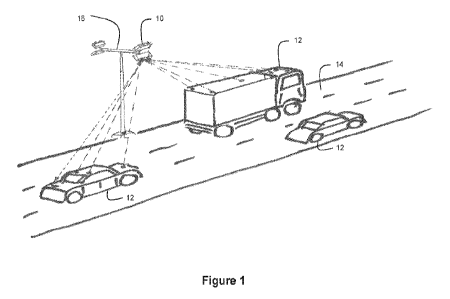
[0035] Turning firstly to Figure 1, there is shown a vehicle tracking
apparatus 10 for detecting one or
more vehicles 12 and determining various kinematic data in respect of the
detected vehicles 12. VVhilst
the term apparatus is used throughout this document, it is to be appreciated
that this term is to be
interpreted as being synonymous to a "device." The vehicle tracking apparatus
10 is shown placed
above a road 14 securely mounted on existing road infrastructure 16 and is
configured to be arranged
to monitor vehicles 12 which enter the fixed field of view of the vehicle
tracking apparatus 10. The
existing road infrastructure 16 to which the vehicle tracking apparatus 10 may
comprise lampposts,
traffic lights, gantries, traffic monitoring equipment and bridges. It is to
be appreciated that this is an
illustrative example and the vehicle tracking apparatus 10 may be mounted to
other existing road
infrastructure 16. Alternatively, the vehicle tracking apparatus 10 may be
provided with dedicated
support structures to which the vehicle tracking apparatus 10 may be attached.
[0036] The vehicle tracking apparatus 10 is configured to receive data which
uniquely identifies the
vehicles 12 that enter its field of view. Such unique identification data may
comprise a vehicle
registration of the vehicle. The vehicle tracking apparatus 10 is additionally
configured to receive data
indicating an initial position of the vehicle 12 either relative to itself or
as an absolute position, as it
enters its field of view of the vehicle tracking apparatus 10. Alternatively,
all these positions could simply
be provided as absolute coordinates such as the latitude and the longitude of
the vehicle. The vehicle
tracking apparatus 10 is then further configured to use the received unique
identification data in
conjunction with the initial position data in order to associate the unique
identification data with the initial
position data. Further details explaining how this may be achieved are given
below with reference to
Figure 3.
[0037] It is to be appreciated that the term 'initial position' as used
throughout this document refers to
the position the vehicle 10 is situated at when it first comes into functional
view of a vehicle tracking
apparatus 10. In addition, in embodiments in which a plurality of vehicle
tracking apparatuses 10 are
used in a networked system (as described below), the initial position of the
vehicle, which is received
by the current vehicle tracking apparatus, may be the last tracked position of
the vehicle in the field of
view of an adjacent vehicle tracking apparatus from which the vehicle is
exiting. Given that the fields of
view of two vehicle tracking apparatus are typically abutting or slightly
overlapping each other, the last
sensed vehicle position in a field of view of a first vehicle tracking
apparatus can provide a very good
indicator of the position the vehicle 10 is situated at when it enters the
field of view of a second adjacent
vehicle tracking apparatus 10.
[0038] The vehicle tracking apparatus 10 is further configured to receive IR
emissions, which are either
emitted or reflected by vehicles 12 which enter the field of view of the
vehicle tracking apparatus 10.
The vehicle tracking apparatus 10 is configured to determine various kinematic
data of the vehicles 12
based upon the received IR emissions. Such kinematic data may comprise a
position, a velocity, an
acceleration, or other kinematic properties of the vehicles 12. In some
embodiments, the kinematic data
7
CA 03182284 2022- 12- 12
WO 2022/003343
PCT/GB2021/051647
determined by the vehicle tracking apparatus 10 is used in conjunction with
the unique identifier data
and initial position data in order to associate the received data with the
detected IR emissions.
[0039] Once a vehicle 12 has entered the field of view of the vehicle tracking
apparatus 10, the vehicle
tracking apparatus 10 may be configured to constantly monitor current
kinematic data of the vehicle 12
until such a time as it leaves the field of view of the vehicle tracking
apparatus 10. As such, once a
vehicle 12 enters the field of view of the vehicle tracking apparatus 10 and
the unique identifier
information and initial position data are received, the vehicle tracking
apparatus 10 is configured to
specifically monitor incremental movements of the vehicle 12 by receiving
consecutive IR emissions
from the vehicle at regular time intervals. Each of the detected IR emissions
can be used by the vehicle
tracking apparatus 10 to determine a position of the vehicle, and the
combination of successive position
determinations allows the calculation of other kinematic data such as velocity
and acceleration. The
measurement of the position at regular time intervals may also be used to
determine if a detected
vehicle 12 is moving transversely (i.e. changing lanes) as well as
longitudinally (i.e. along the road).
The length of the time intervals between consecutive detected IR emissions may
be used to determine
the latency and accuracy of the kinematic data that is calculated. For
example, if IR emissions are
detected to an accuracy of 5cm with a periodicity of 20ms (a frequency of
approximately 50Hz), this
translates to a measurement every 50cm of travel by a vehicle travelling at
100Km/h. This is considered
to be highly accurate for the purposes of vehicle control and navigation and
will also enable vehicle
velocity, acceleration/deceleration rates, or other useful kinematic data to
be calculated quickly and
accurately. These figures should be considered as illustrative only since if
less demanding accuracies
and latencies prove adequate in practice then they can be substituted and if
more demanding
accuracies and latencies prove necessary in practice they can be substituted.
[0040] The vehicle tracking apparatus 10 may be further configured to transmit
the determined current
kinematic data to the one or more detected vehicles 12. The transmitted
kinematic data may comprise
any one of the kinematic data determinations made by the vehicle tracking
apparatus 10. The provision
of the kinematic data enables the one or more detected vehicles 12 to adjust a
kinematic quantity (for
example speed, or direction of travel) of the relevant vehicle 12 in
accordance with the received
kinematic information. In some embodiments, the vehicle tracking apparatus 10
is configured to only
transmit determined current kinematic data relating to the vehicle 12 it
relates to. In such an
embodiment, the vehicle 12 is then able to adjust kinematic quantities based
on this knowledge (e.g. to
reduce or increase velocity, to move within a lane if it is indicated that
vehicle is straying into a different
lane etc). In further embodiments, the vehicle tracking apparatus 10 is
configured to transmit determined
kinematic data relating to a plurality of the detected vehicles 12 to each
vehicle. In such an embodiment,
each vehicle 12 then may adjust kinematic qualities both with knowledge of the
vehicle's 12 own
kinematic data, as well as the kinematic data of other vehicles 12 in the
vicinity. By way of example, a
first vehicle 12 is provided with current kinematic data indicating that the
velocity and position of second
vehicle 12 directly in front of the first vehicle, such that it is possible
for the first vehicle to safely move
closer to the second vehicle 12.
[0041] The current kinematic data is transmitted to one or more vehicles 12
which may be either
partially or entirely autonomously operated or may be operated with input from
a driver or pilot or remote
controller of the vehicle 12. The format of the transmission made by the
vehicle tracking apparatus 10
may be arranged to suitably meet the needs of the recipient vehicle 12. In
further embodiments of the
present invention, the vehicle tracking apparatus 10 is configured to
additionally send a control signal
to the one or more vehicles 12, causing the vehicle to take a particular
action. The control signal may
be formed on the basis of the calculated current kinematic data of the one or
more vehicles 12. By way
of example, if it is determined that two detected vehicles 12 in the field of
view of the vehicle tracking
apparatus 10 are within a predetermined distance of one another based upon the
calculated velocities
of the two vehicles 12, the vehicle tracking apparatus 10 generates a control
signal to be transmitted to
one of the vehicles 12 informing the vehicle to either speed up or slow down
accordingly.
8
CA 03182284 2022- 12- 12
WO 2022/003343
PCT/GB2021/051647
[0042] In additional embodiments, the vehicle tracking system 10 is also
configured to transmit
determined current kinematic data to local or regional Traffic Management
Systems (TMSs) to provide
a shared, common picture comprising the high-accuracy kinematic data for
vehicles 12 across a wider
field spanning multiple IR tracking sensors. This provides the TMSs with live,
accurate data for each
vehicle 12 and allows the TMSs to augment the determined current kinematic
data provided to the one
or more vehicles 12 about their immediate locality with advisory or compulsory
information that the on-
board systems of the one or more vehicles 12 deal with relating to traffic
management. That information
may be provided to the one or more vehicles 12 via the vehicle tracking system
10 or by any other
appropriately configured systems and networks.
[0043] It is to be appreciated that the vehicle tracking apparatus 10 may be
securely mounted at
various heights. The height at which the vehicle tracking apparatus 10 is
mounted typically determines
the ground envelope within the field of view of the vehicle tracking apparatus
10 i.e., a vehicle tracking
apparatus 10 which is mounted at a higher position may have a greater area
within its field of view than
a vehicle tracking apparatus 10 which is mounted at a lower position. The
height at which the vehicle
tracking apparatus 10 is mounted therefore will largely depend upon the field
of view requirements.
Typically, a vehicle tracking apparatus 10 which is mounted at a height of 10m
will need to have a field
of view of 1400 longitudinally (i.e. along the road) and 50 transversely
(i.e. across the road) in order to
cover a ground envelope typically associated with a lamppost on a motorway or
freeway.
[0044] In further embodiments of the vehicle tracking apparatus 10, it is
desirable to be able to alter
the field of view of the vehicle tracking apparatus 10 in use, perhaps at the
time of installation in order
to cover the required ground envelope. For example, it may be desirable to
move the field of view such
that the vehicle tracking apparatus 10 is able to view a different carriageway
of a motorway. In such
embodiments, the vehicle tracking apparatus 10 is configured to rotate around
at least one axis in order
to adjust the ground envelope within the field of view, and possibly to have
adjustable optics to vary the
field of view, thereby providing the apparatus 10 with a variable ground
envelope coverage within the
field of view. In such embodiments, the apparatus 10 is configured to take
into account the current
position and orientation of the vehicle tracking apparatus 10 when determining
current kinematic data
of the one or more vehicles 12.
[0045] VVhere a plurality of vehicles 12 are present in the field of view of
the vehicle tracking apparatus
10, the vehicle tracking apparatus 10 may be configured to receive relevant
data and IR emissions
from, and calculate current kinematic data of each of the vehicles 12
simultaneously, in accordance
with embodiments described herein. The vehicle tracking apparatus may also be
used to detect IR
emissions from entities other than vehicles, for example pedestrians or
cyclists or animals, and enhance
the ability of the tracking apparatus to support the safe operation of
vehicles in environments where
pedestrians or cyclists are present legitimately or where pedestrians or
animals should not be present.
The field of view of the tracking apparatus may extend to cover pavements or
walkways adjacent to
roadways so that pedestrians/animals can be tracked.
[0046] It is envisaged that in some cases, the vehicle tracking apparatus 10
operates in an
environment in which not all of the vehicles which pass into its field of view
have the capability to either
emit or reflect IR radiation to be detected by the vehicle tracking apparatus
10. In such cases, these
vehicles may be restricted to a particular, possibly slowest lane(s) by
physical barriers, road signage,
on-board vehicle lane-tracking control or any combination of these or other
methods. It is further
envisaged that in some situations one vehicle may obscure the IR emissions or
reflections from another
vehicle ¨ for example if a small car is travelling behind and close to a large
truck as they approach a
sensor. In such cases, either the IR sensor can be fixed at a greater height
or the traffic flows can be
restricted by traditional means to keep similar sized vehicles in appropriate
lanes. Further, a vehicle
tracking apparatus 10 may be configured to receive IR emissions from multiple
angles, such that IR
9
CA 03182284 2022- 12- 12
WO 2022/003343
PCT/GB2021/051647
emissions may still be received even where at certain angles the emissions are
blocked from view of
the vehicle tracking apparatus 10. In this regard, the vehicle tracking
apparatus may comprise a plurality
of different IR sensors located at different positions, for example at
different heights. In such
embodiments, where emissions are detected from multiple angles, the vehicle
tracking apparatus 10
may be configured to compare the detected emissions to verify the veracity of
the emissions.
[0047] Referring now to Figure 2, there is shown an alternate use scenario for
the vehicle tracking
apparatus 10 described in Figure 1. In this embodiment, the vehicle tracking
apparatus 10 is shown
mounted on existing road infrastructure. However, in this scenario, the
vehicle tracking apparatus 10 is
configured to monitor airborne vehicles 20. It is to be appreciated that
embodiments described above
may be suitably adapted in order to monitor airborne vehicles rather than
ground-based vehicles. The
tracking apparatus, in other embodiments, may also be mounted on vehicles, for
example ships, trains,
aircraft or spacecraft, so that other vehicles, for example other aircraft or
airborne drones or other
spacecraft can be tracked in an accurate manner thereby supporting complex
operations such as
aircraft landing on ships, drones landing on trains or spacecraft docking
operations. Further discussions
of how vehicle tracking apparatus can be mounted to existing road
infrastructure are given below.
[0048] It is to be appreciated that in the use scenario of Figure 1, the
vehicle tracking apparatus is
configured to monitor ground-based vehicles 12 which are generally restricted
to travel along predefined
paths (i.e. roads in cities, countryside and motorways). In the use scenario
of Figure 2 however, the
airborne vehicles 20 which are to be monitored are not physically restricted
in such a manner, and as
such it is envisaged that it may be necessary to mount the vehicle tracking
apparatus 10 in places
outside of purely road-based infrastructure. Therefore, in use scenarios as
illustrated in Figure 2, the
vehicle tracking apparatus 10 is configured to be securely mounted on any
existing infrastructure,
regardless of its proximity to a roadside. Alternatively, the vehicle tracking
apparatus 10 may also be
provided with dedicated support structures to which the vehicle tracking
apparatus 10 may be attached.
Additional considerations regarding such arrangements will be discussed in
further detail with reference
to Figure 4. Whilst it is envisaged that it will be possible to mount the
vehicle tracking apparatus 10 for
monitoring airborne vehicles 20 in places outside of purely road-based
infrastructure, it is to be
appreciated that airborne vehicles 20 may also still be configured to travel
along existing road and rail
infrastructure in a manner analogous to that of the ground-based vehicle 12
example. As a result, even
when monitoring airborne vehicles 20, the vehicle tracking apparatus 10 may
still be configured to be
mounted to the same existing roadside / rail-side infrastructure as described
previously.
[0049] Whilst the use scenarios of Figures 1 and 2 are shown separately, it is
to be appreciated that a
single vehicle tracking apparatus 10 may be provided which is configured to
monitor both ground-based
12 and airborne vehicles 20. This is achieved by providing sensors, which are
oriented in different
directions (namely having different fields of view) to monitor the two types
of vehicle. In such scenarios,
the vehicle tracking apparatus 10 is configured to only send determined
current kinematic data
regarding airborne vehicles 20 to the one or more airborne vehicles 20, and
similarly is configured to
only send determined current kinematic data regarding ground-based vehicles 12
to the one or more
ground-based vehicles 12. Additionally or alternatively, the vehicle tracking
apparatus 10 may be
configured instead to be able to send determined current kinematic data
regarding airborne vehicles 20
to one or more ground-based vehicles 12 and vice versa. This advantageously
enables ground-based
vehicles 12 and airborne vehicles 20 to coordinate their locations. For
example, this may be used for
ground-to-air battery charging, where airborne vehicles operating under
electrical power provided from
a battery could dock with a battery recharging truck or train. It may also be
used in a use scenario of a
delivery lorry or train with a swarm of airborne delivery drones that travel
with the lorry or train into the
delivery area and then split off, deliver to door, and return. It may further
be used in a use scenario
where collector drones pick up consignments and deliver to trucks or trains
for long-distance
transportation. One further advantage of sharing airborne vehicle data with
ground-based vehicles and
vice versa is that physical spaces can be created in the ground-based vehicles
positions above which
CA 03182284 2022- 12- 12
WO 2022/003343
PCT/GB2021/051647
airborne vehicles can travel. This would be a safety configuration such that
if the airborne vehicle were
to lose altitude or crash, there would be no ground-based vehicles below the
airborne vehicles, which
would minimise the risk for collision. It is to be appreciated that these use
scenarios are for illustrative
purposes only, and it is intended that such an embodiment may be utilised in
many other applications.
Further details regarding these embodiments are described in further detail
with reference to Figure 4
below.
[0050] Turning to Figure 3, there is shown an example of a ground-based
vehicle 12, which the vehicle
tracking apparatus 10 of Figure 1 is configured to detect. Figure 3 shows a
vehicle 12 which is fitted
with IR emitters 30A, 30B, 30C, 30D, 30E placed on an upward facing surface of
the vehicle 12. Whilst
five emitters 30A, 30B, 30C, 30D, 30E are shown in Figure 3, it is to be
appreciated that this is for
illustrative purposes only and any suitable number of emitters may be used
which enable the
functionality of the vehicle tracking apparatus 10. It is also to be
appreciated that emitters may be fixed
to the front, rear or sides of vehicles. The use of these in relation to a
ground space envelope of the
vehicle is described later.
[0051] The vehicle 12 is also provided with a transmitter 32 and receiver 34
(or a combined transceiver)
configured to transmit and receive wireless signals respectively. Upon
entering the field of view of a
vehicle tracking apparatus 10, the vehicle 12 is configured to transmit a
wireless signal to the vehicle
tracking apparatus 10. The wireless signal comprises unique identification
data of the vehicle 12 as well
as the data indicating an initial position of the vehicle 12 with respect to
the vehicle tracking apparatus
or indicating absolute position of the vehicle. This provision of initial
positioning may be particularly
useful if the vehicle is unknown to the system, namely at an entry point to
the system. However, it is not
envisaged that the network of sensors would require this information once the
vehicle was being tracked
by the system. The information which can be received from the vehicle once
known to the network is
described below.
[0052] The vehicle 12 may typically be configured to transmit data indicating
the position of the IR
emitters 30A, 30B, 30C, 30D, 30E with respect to a ground-envelope 36 of the
vehicle 12. The ground-
envelope 36 provides an indication of the two-dimensional footprint of the
vehicle representing the
space that the vehicle 12 occupies on the road as it is travelling. When IR
emissions emitted from the
IR emitters 30A, 30B, 30C, 30D, 30E are detected by the vehicle tracking
apparatus 10, the emissions
may be used in conjunction with the information regarding the ground-space
envelope in order to
determine the two-dimensional space that the vehicle 12 occupies. In this way,
it is not necessary for
the vehicle tracking apparatus 10 to fully resolve an image of the vehicle for
the purposes of determining
in a safe and reliable manner the vehicle's proximity to other vehicles. In
some embodiments, the
ground-space envelope additionally includes some space surrounding the vehicle
to act as a safety
zone around the perimeter of space that the vehicle occupies. In addition, the
provision of the position
of the IR emitters 30A, 30B, 30C, 30D, 30E with respect to the ground-envelope
36 may also help in
determining the orientation kinematic data, in which the vehicle tracking
apparatus 10 is able to
determine the orientation of the relevant vehicle 12 on the road (i.e. whether
it is aligned precisely along
the road or whether it is angled, so as to change position across the road).
In embodiments in which an
airborne vehicle 20 is to be tracked, a ground space envelope 36 is not
appropriate. In such cases, the
airborne vehicles 20 may be configured to provide an air space envelope. In
some embodiments, the
air space envelope may again provide a two-dimensional footprint of the
vehicle representing the two-
dimensional space that the vehicle 20 occupies in the air as it is travelling.
In further embodiments, the
air space envelope may provide a three-dimensional footprint of the vehicle
representing the three-
dimensional space that the vehicle 20 occupies in the air as it is travelling.
[0053] In Figure 3, the IR emitters 30A, 30B, 30C, 30D, 30E are shown arranged
in a particular
formation. It is to be appreciated that in addition to the number of IR
emitters 30A, 30B, 30C, 30D, 30E
being variable, the pattern in which they are arranged in may similarly be
variable. In some
11
CA 03182284 2022- 12- 12
WO 2022/003343
PCT/GB2021/051647
embodiments of the present invention, the vehicle tracking apparatus 10 is
configured to associate a
particular pattern of IR emitters with a particular type of vehicle (e.g.
lorry, car, drone, motorcycle etc).
When a particular spatial pattern of IR emission is detected, the vehicle
tracking apparatus 10 is
configured to recognise the type of vehicle that is being detected. Such
patterns preclude
misidentification due to adjacent vehicle coincidences. Standard
configurations for particular vehicle
types may comprise, for example, a triangular array of 3 IR emitters for cars
and a domino array of 5
IR emitters for trucks and vans. These configurations help to enable
unambiguous sensing and
determination of kinematic data (such as position, velocity, acceleration,
deceleration, orientation, etc).
Information related to the type of vehicles 12 in the field of view of the
vehicle tracking apparatus 10
may also be transmitted to the one or more detected vehicles 12 in the field
of view of the tracking
apparatus. Furthermore, in embodiments where the vehicle tracking system 10 is
configured to
generate a control signal, the vehicle tracking apparatus 10 is configured to
use information relating to
the type of vehicle being detected to determine the content or type of control
signal to be generated.
For example, when two adjacent vehicles 12 are determined to be in the
vicinity of one another, the
control signal generated by the vehicle tracking apparatus 10 typically
differs for a truck and a car, due
to the associated differences in stopping distance.
[0054] In some embodiments, the IR emitters 30A, 30B, 30C, 30D, 30E are
replaced by IR reflectors.
This embodiment is used in cases where the vehicle tracking apparatus 10 is
provided with one or more
IR emitters which are configured to emit IR radiation into the field of view
of the vehicle tracking
apparatus 10 and to detect IR radiation which is reflected by IR reflectors on
the one or more vehicles
12 in order to track them.
[0055] Turning to Figure 4, there is shown in greater detail a schematic view
of the vehicle tracking
apparatus of Figure 1. The vehicle tracking apparatus 10 firstly comprises a
receiver 40 configured to
wirelessly receive transmitted data in accordance with embodiments above. In
particular, the receiver
40 is configured to at least receive unique identification data of one or more
vehicles 12 in the field of
view of the vehicle tracking apparatus 10 and to receive data indicating an
initial position of the one or
more vehicles 12 relative to the vehicle tracking apparatus 10. The receiver
40 may be configured to
wirelessly receive data transmitted from the one or more vehicles 12 via an
external communications
network 42. The receiver 40 may be configured to receive this data via a low-
latency radio frequency
communication. Alternatively, the receiver 40 may receive this data using any
suitable form of
communication, which enables the data to be received from the one or more
vehicles 12. In some
embodiments, the receiver 40 is additionally configured to receive data
originating from sources other
than the one or more vehicles 12, such as other vehicle tracking apparatuses
10 or centralised traffic
management systems (not shown). Such data is again transmitted via the
external communications
network 42. In some embodiments, the receiver 40 is configured to receive data
through wired
communications where appropriate, i.e. where the receiver 40 is configured to
receive data from fixed
locations (such as a centralised traffic management system or adjacent
tracking apparatuses).
[0056] In some embodiments of the present invention, the vehicle tracking
apparatus 10 is configured
to monitor an area or "entry point" whose position is preconfigured to be
known to the vehicle tracking
apparatus 10 (e.g. by storing this position in a memory 48 of the vehicle
tracking apparatus). In such
embodiments, it may not be necessary for the vehicle tracking apparatus 10 to
receive information from
the one or more vehicles 12 regarding an initial position of the one or more
vehicles 12. In such
embodiments, the vehicle tracking apparatus 10 may be configured such that the
initial position of a
particular vehicle 12 will always be the position that is preconfigured to be
known to the vehicle tracking
apparatus 10 as described above. In further embodiments, the vehicle tracking
apparatus 10 is
configured to monitor several locations in an entry point (e.g. a plurality of
lanes), each of these with
their own known preconfigured position. In such embodiments, when a vehicle 10
enters an entry point,
the vehicle tracking apparatus 10 may be configured to select one of the
plurality of preconfigured
positions as being the initial position of the vehicle 10. The method by which
such a selection may be
12
CA 03182284 2022- 12- 12
WO 2022/003343
PCT/GB2021/051647
made is described in further details with reference to the "association"
procedure described below. Such
an entry point embodiment may manifest at a toll booth, where a vehicle is
configured to stop at a
particular location which is known by the vehicle tracking apparatus 10. In
some embodiments, the
vehicle 12 will not need to be stationary when approaching the known location.
[0057] In additional or further embodiments, the vehicle tracking apparatus 10
may also be configured
to determine unique identification data of one or more vehicles 12 rather than
receive it from the
respective vehicle 12. This may be achieved by providing the vehicle tracking
apparatus 10 with a
sensor (not shown in the accompanying figures) which is able to determine a
unique identifier of a
vehicle 10 (for example, a license plate / number plate of the vehicle) or to
identify and classify the
vehicle (for example using image processing) and assign a unique identifier
for the purpose of
monitoring the position of the vehicle more approximately. Such a sensor may
comprise an Automatic
Number Plate Recognition (ANPR) camera or other suitable camera or sensor
which is able to uniquely
identify a particular vehicle 10 or to detect and assign a unique identifier.
Such embodiments may also
be used in combination with embodiments described above where the vehicle
tracking apparatus 10 is
configured to monitor an area or "entry point" whose position is preconfigured
to be known to the vehicle
tracking apparatus 10. In such cases, it may not be necessary for the vehicle
tracking apparatus 10 to
receive any data transmissions from the one or more vehicles 10 whatsoever,
with the determination
and assignment of initial positions, and determination of unique
identification being performed entirely
by the vehicle tracking apparatus 10. However, where information relating to
ground-space envelopes
is also to be received by the vehicle tracking apparatus 10, this may still
need to be provided by the
respective vehicle 12.
[0058] Additionally, the vehicle tracking apparatus 10 may comprise one or
more IR sensors 44
configured to detect IR radiation, and specifically to detect IR radiation
either being emitted from or
reflected by the IR emitters or reflectors 30A, 30B, 30C, 30D, 30E of the one
or more vehicles 12 to be
tracked in accordance with embodiments described above. In Figure 4, only one
IR sensor 44 is shown,
but it is to be appreciated that this is for illustrative purposes only and
that in some scenarios, it is
beneficial to include a plurality of IR sensors 44. For example, a plurality
of IR sensors 44 may be
provided, where each IR sensor has a different field of view of a road or
perhaps a road intersection
which it is directed towards. This enables dedicated IR sensors 44 to be
provided for each lane of the
road. Alternatively, and in accordance with embodiments described above,
multiple IR sensors 44 may
be provided, where one or more of the IR sensors 44 are configured to monitor
a road, and one or more
of the IR sensors 44 are configured to monitor the sky. In this way, a single
vehicle tracking apparatus
may be configured to monitor both airborne vehicles 20 and ground-based
vehicles 12 in accordance
with embodiments described above. The same arrangement could apply for example
on an aircraft
carrier where both aircraft movements on deck and approaching airborne
aircraft are being tracked.
The IR sensors 44 may be configured to detect IR radiation in a predetermined
range of wavelengths,
where the predetermined range is decided by a user of the vehicle tracking
apparatus 10. In particular,
the predetermined range of wavelengths may specifically correspond to a range
of wavelengths emitted
or reflected by the one or more vehicles 12. This enables the vehicle tracking
apparatus 10 to reduce
detection of IR noise, which may be emitted by sources other than the one or
more vehicles 12 to be
tracked.
[0059] The vehicle tracking apparatus 10 of the current embodiment, further
comprises a processor
46, which is communicably coupled to the receiver 40 and the one or more IR
sensors 44. The processor
46 is configured to receive data which is received by the receiver 40 in
accordance with embodiments
described above, as well as information related to the detected IR emissions
received by the one or
more IR sensors 44. The processor 46 is further configured to track the one or
more vehicles 12 on the
basis of the received data and the detected IR emissions. This tracking
comprises the calculation of
various kinematic data relating to the one or more vehicles 12. In particular,
the processor 16 is
configured to at least determine a position that the IR emissions originate
from. This may be determined,
13
CA 03182284 2022- 12- 12
WO 2022/003343
PCT/GB2021/051647
for example, by processing the IR image within the sensor, or by determining
an angle that the IR
emission has entered the IR sensor 44 at and combining this with known
information relating this angle
to a particular position on the road. The information received by the
processor 46 may comprise any
relevant information, which enables the processor to determine a position that
the IR emissions
originate from (e.g. time that the emissions are received, angle that the IR
emissions enters the IR
sensor 44 at etc).
[0060] The processor 46 is configured to receive the unique identification
data of one or more vehicles
12 in the field of view of the vehicle tracking apparatus 10 and to receive
data indicating an initial position
of the one or more vehicles 12 relative to the vehicle tracking apparatus 10,
and to correlate this data
with the information related to the detected IR emissions received by the one
or more IR sensors 44. In
this way, the processor 46 is able to associate a particular IR emission with
a unique identifier of the
vehicle 12 that emitted or reflected the IR radiation. This correlation may
comprise comparing the initial
position data received by the receiver 40 with a determined position that the
received IR emissions
originate from to establish whether the two positions are in agreement. Where
the two positions are in
agreement, the processor 46 is configured to associate the received IR
emissions with unique identifier
data of the vehicle 12 whose initial position data agrees with the position of
origin of the IR emissions.
Upon agreement, the processor 46 may be configured to denote the now
identified vehicle 12 as having
a particular position in accordance with the initial position data and/or the
origin point of the IR
emissions. In some embodiments, agreement is determined where the initial
position data and the
position of the IR emissions lie within a margin of error of one another. In
embodiments where a single
vehicle is provided with a plurality of IR emitters or reflectors 30A, 30B,
30C, 30D, 30E, the processor
46 is configured to associate the received IR emissions from the plurality of
IR emitters or reflectors
30A, 30B, 30C, 30D, 30E with the unique identifier of the vehicle 12 that
emitted or reflected the IR
radiation. This may be achieved analogously to the above described
embodiments, but in addition the
received unique identification may comprise initial position data for each of
the a plurality of IR emitters
or reflectors 30A, 30B, 30C, 30D, 30E and an indication of the total number of
IR emitters or reflectors
30A, 30B, 30C, 30D, 30E on the vehicle 12.
[0061] In accordance with some embodiments described above, the vehicle
tracking apparatus 10 is
configured to monitor an area or "entry point" whose position is preconfigured
to be known to the vehicle
tracking apparatus 10 and which may be utilised as the initial position data
for a vehicle 12. As
mentioned above, such a position may be stored in a memory 48 of the vehicle
tracking apparatus 10.
In these embodiments, when the processor 46 associates a detected IR emission
with unique
identification data, the initial position of the vehicle 12 is assigned as
being the preconfigured position
known to the vehicle tracking apparatus 10. This position may be retrieved
from the memory 48 by the
processor 46 accordingly. In further embodiments in which the vehicle tracking
apparatus 10 is
configured to monitor several locations in an entry point (e.g. a plurality of
lanes), each of these with
their own known preconfigured position, the processor 46 is configured to
determine which of the
plurality of preconfigured positions should be assigned as an initial position
of the vehicle 12. This may
be accomplished by comparing the origin positions of the received IR emissions
to each of the
preconfigured positions and assigning the initial position based on this
comparison. In some
embodiments, this assignment is performed when a comparison between the origin
positions of the
received IR emissions and a preconfigu red position lie within a margin of
error of one another. In other
embodiments, this assignment is performed by comparing all preconfigured
positions with the origin
positions of the received IR emissions and assigning the initial position as
being the preconfigured
position which lies closest to the origin positions of the received IR
emissions. The above provided
examples are provided for illustration only and any suitable comparison method
may be performed
which achieves the required functionality described above.
[0062] Following the association of a vehicle 12 with a particular detected IR
emission or emissions in
accordance with embodiments described above, the processor 46 is configured to
store information
14
CA 03182284 2022- 12- 12
WO 2022/003343
PCT/GB2021/051647
related to the association in a memory 48 to which the processor 46 is
communicably coupled. The
information stored in the memory 48 comprises the unique identifier of the
associated vehicle 12 as well
as its determined position. The information stored in the memory 48 may
additionally comprise any
other determined kinematic data in accordance with embodiments described
herein. The memory 48
may be configured to be accessed by the processor 46 at a later time to
retrieve information related to
one or more previously associated vehicles 12. This retrieval may be used to
determine other kinematic
data of the vehicle or vehicles 12 in accordance with embodiments described
herein.
[0063] Upon receipt of information related to the detected IR emissions
received by the one or more
IR sensors 44, the processor 46 may additionally be configured to determine
whether the detected IR
emissions have been emitted or reflected by a vehicle 12 whose unique
identification has previously
been associated with detected IR emissions. This is achieved by retrieving
from the memory 48
information regarding determined positions of vehicles 12 which have been
stored in accordance with
embodiments described above and comparing these with the origin position of
the currently detected
IR emissions. If it is determined that the origin of the current IR emissions
is sufficiently close to a
previously determined position of a vehicle 12 after a known time interval,
the processor 46 is configured
to associate the presently detected IR emission with this vehicle and to
denote the origin of the presently
detected IR emission as a new position of the vehicle 12. The determination of
whether the origin is
sufficiently close may be achieved by calculating the difference in the
position between the origin of the
IR position and the previously determined position of the vehicle 12, and
where the difference is below
a predetermined threshold, the processor 46 associates the origin of the IR
emissions as being the new
position of the vehicle 12. The predetermined threshold may be set by a user.
The predetermined
threshold may also be based on other factors, such as a velocity of the
vehicle 12 and the refresh rate
of the IR sensor 44. This new position may then be stored in the memory 48. In
some embodiments,
the new position overwrites the previously determined position. In other
embodiments, the new position
is stored in addition to the previously determined position or positions with
a timestamp, creating a
record of all positions that the vehicle 12 has been at since it was first
detected. In such embodiments,
when determining whether subsequent emissions relate to the vehicle 12 record,
the origin of the IR
emissions is compared with the most recent position of the vehicle 12 in
accordance with the timestamp.
The processor 46 may be configured to perform this determination as frequently
as the IR sensor 44
receives emissions. As noted above, the length of the time intervals between
consecutive detected IR
emissions may be used to determine the accuracy of the kinematic data which is
calculated. For
example, if IR emissions are detected with a periodicity of 8ms (a frequency
of approximately 120Hz),
this translates to a 20cm distance of travel by the vehicle. This is
considered to be highly accurate for
the purposes of vehicle control and navigation and also enables vehicle
velocity,
acceleration/deceleration rates, or other useful kinematic data to be
calculated quickly and accurately.
These figures should be considered as illustrative only since if less
demanding accuracies and latencies
prove adequate in practice then they can be substituted and if more demanding
accuracies and
latencies prove necessary in practice they can be substituted.
[0064] The processor 46 may additionally be configured to retrieve information
from the memory 48 in
relation to a particular vehicle in order to calculate additional kinematic
data of the vehicle 12. In
particular, the processor may be configured to retrieve a plurality of
positions of a particular vehicle 12
and their associated timestamps (known as a vehicle track record over a period
of time) in order to
calculate a velocity and/or an acceleration of the vehicle 12. The velocity
and acceleration may be
calculated in two dimensions (i.e. along the road and across the road). The
calculation may be
performed in accordance with techniques known to the person skilled in the
field and so do not need to
be described further here. By calculating this additional kinematic data, more
information may be
determined regarding the vehicle 12, which may additionally be used for more
accurate control of the
vehicle 12 when the information is provided to the vehicle 12. The calculated
kinematic data may
additionally be stored in the memory record of the relevant vehicle 12.
CA 03182284 2022- 12- 12
WO 2022/003343
PCT/GB2021/051647
[0065] In further embodiments of the present invention, the processor 46 is
configured to additionally
generate a control or warning signal to be enacted by the one or more vehicles
12, causing the vehicle
to take a particular action. The control signal may be formed on the basis of
the calculated current
kinematic data of the one or more vehicles 12 in accordance with the
embodiments above. In such
embodiments, the processor 46 is configured to retrieve kinematic data from
the memory 48 for all
vehicles 12 in the field of view of the tracking apparatus 10 in order to
determine an action to be taken.
By way of example, if it is determined that two detected vehicles 12 in the
field of view of the vehicle
tracking apparatus 10 are within a predetermined distance of one another based
upon the calculated
velocities of the two vehicles 12, the processor 46 generates a control or
warning signal to be
transmitted to one of the vehicles 12 telling the vehicle to either speed up
or slow down accordingly.
[0066] In some embodiments, when a vehicle 12 moves out of the field of view
of the vehicle tracking
apparatus 10, the processor 46 is configured to instruct the memory to delete
any stored information
relating to the vehicle 12.
[0067] In embodiments in which the vehicle tracking apparatus 10 is configured
to receive information
indicating the position of the IR emitters 30A, 30B, 30C, 30D, 30E with
respect to a ground-envelope
36 of the vehicle 12, the processor 46 may be additionally be configured to
combine this information
with the information related to the detected IR emissions received by the one
or more IR sensors 44 to
determine a position/orientation of the ground envelope 36 of the vehicle 12.
In some embodiments,
the position of the ground envelope 36 is determined relative to the vehicle
tracking apparatus 12 and/or
is determined as an absolute position of the ground envelope 36.
[0068] In these embodiments, where the vehicle 12 that the ground envelope 36
relates to has not
previously been associated, the calculation of the position of the ground
envelope 36 is performed as
part of the initial association step. When the correlation of the detected IR
emissions and the unique
identification data of a vehicle 12 is performed to indicate an initial
position of the vehicle 12, the
processor 46 will additionally combine the initial position data of each of
the IR emitters 30A, 30B, 30C,
30D, 30E with the information regarding the position of each of the IR
emitters 30A, 30B, 30C, 30D,
30E with respect to the ground envelope 36. In this manner, the initial
position of the ground envelope
36 is generated and an indication of the two-dimensional space that the
vehicle 12 initially occupies is
generated without requiring an image of the vehicle 12 to be fully resolved.
As described in above
embodiments, the ground space envelope may additionally include some space
surrounding the vehicle
to act as a safety zone around the perimeter of space that the vehicle 12
occupies. Once the initial
ground envelope 36 position is determined, this information is stored in
memory 48 analogously to the
procedure described above regarding the initial positions of the IR emitters
30A, 30B, 30C, 30D, 30E,
in addition to the ground space envelope 36 information which has been
provided regarding the position
of the IR emitters 30A, 30B, 30C, 30D, 30E relative to the ground space
envelope 36.
[0069] Where the ground envelope 36 is to be calculated for a vehicle 12 whose
unique identification
has already been associated in accordance with embodiments described above,
the processor 46 may
additionally retrieve the stored ground envelope 36 information from the
memory 48. When it is
determined that the IR emissions relates to a vehicle 12 that has previously
been associated, the
processor 46 will retrieve information regarding the position of the IR
emitters 30A, 30B, 30C, 30D, 30E
relative to the ground space envelope 36 which has previously been stored.
This information may then
be combined with the detected origin points of the IR emitters 30A, 30B, 30C,
30D, 30E in an analogous
manner to the above. Similarly, any calculated new position of the ground
envelope 36 may similarly
be stored in the memory 48 along with the positions of the IR emitters 30A,
306, 300, 30D, 30E and
any associated time stamps.
[0070] Whilst a position/orientation of a ground space envelope 36 has been
discussed as being
calculated, it is to be appreciated that other kinematic data (such as
velocity and acceleration) may be
16
CA 03182284 2022- 12- 12
WO 2022/003343
PCT/GB2021/051647
equally calculated in respect of the ground space envelope 36 of the vehicle
12 and subsequently stored
in the memory 48. Furthermore, any of the functionality of the vehicle
tracking apparatus 10 described
herein which relates to the ground space envelope is also applicable to an air
space envelope for
airborne vehicles.
[0071] The vehicle tracking apparatus 10 may additionally comprise a
transmitter 50 which is
communicably coupled to the processor 46. The transmitter 50 may be configured
to receive the
determined kinematic data from the processor 46 and subsequently transmit this
to one or more
vehicles 12 in the field of view of the vehicle tracking apparatus 10. The
transmitter 50 may be
configured to transmit this data via a low-latency radio frequency
communication. Alternatively, the
transmitter 50 may transmit this data using any suitable form of
communication, which enables the data
to be received by the one or more vehicles 12.
[0072] The transmitter 50 may be configured to transmit the determined
kinematic data of a vehicle 12
only to the vehicle 12 that it relates to. In such embodiments, the data is
received by the vehicle in order
to self-regulate a position and/or velocity of the vehicle 12 based on only
its own kinematic data. To this
end, each vehicle 12 may have a unique, or locally unique, communication
frequency through which it
may transmit and receive data. This information may be provided as part of the
unique identification
data in accordance with embodiments described above. In some embodiments, the
communications
channel may be encrypted in order to prevent unauthorised interception of or
interference with the
transmissions.
[0073] In further embodiments, the transmitter 50 is configured to transmit
determined kinematic data
of one or more vehicles 12 to a plurality of the one or more vehicles 12. The
data may be transmitted
in accordance with embodiments described above. In such embodiments, the data
is received by the
vehicle in order to self-regulate a position, velocity and/or acceleration of
the vehicle 12 based on its
own kinematic data as well as the kinematic data of vehicles 12 in its
vicinity. For example, a vehicle
12 may be configured to receive kinematic data relating to itself as well as
that of the vehicles around
it, and based on all of this information, the acceleration or velocity and
hence position of the vehicle 12
is adjusted accordingly (e.g. if it is noted that another vehicle in the
vicinity is further away than a
particular threshold distance, the vehicle 12 is configured to adjust its own
position to close this distance,
or vice versa).
[0074] Where kinematic data is transmitted in accordance with the above, in
embodiments where a
ground space envelope 36 position of the vehicle 12 (and any other associated
kinematic data) is
calculated, this kinematic data may equally be transmitted in an analogous
manner.
[0075] In embodiments where the processor 46 generates a control or warning
signal, the transmitter
50 is additionally configured to transmit the generated control or warning
signal to the one or more
vehicles 12. In this embodiment, the transmitter 50 is configured to only
transmit the control or warning
signal to the vehicle 12 to which it relates. This may be achieved analogously
to the way in which
kinematic data may only be transmitted to the vehicle 12 to which it relates
as described above.
[0076] In embodiments in which a control signal or warning is generated and
kinematic information
regarding a ground space envelope 36 of one or more vehicles 12 is provided
and/or calculated, the
control signal or warning may be generated based on the kinematic information
of the ground space
envelope 36. As previously discussed, the ground space envelope 36 of a
vehicle may be provided with
a safety zone around the perimeter of space that the vehicle 12 occupies. By
basing a control signal or
warning on the basis of the kinematic data of the ground space envelope 36,
this safety zone is taken
into account. This may act so as to offer an additional safety mechanism to
the system such that the
one or more vehicles 12 are maintained at a safe proximity to one another.
This may be particularly
17
CA 03182284 2022- 12- 12
WO 2022/003343
PCT/GB2021/051647
advantageous in mitigating against small positional determination errors of
the one or more vehicles
12.
[0077] The transmitter 50 may also be configured to transmit determined
current kinematic data to
local or regional Traffic Management Systems (TMSs) to provide a shared,
common picture comprising
the high accuracy kinematic data for vehicles 12 across a wider field spanning
multiple IR tracking
sensors. The advantages of such a transmission are described above. The
receiver 40 may also be
configured to receive control, warning or advisory information from local or
regional TMSs and pass it
on to the vehicles 12 via the transmitter 50. Alternatively, the TMSs may
provide control, warning or
advisory information to the vehicles 12 by some other appropriately configured
mechanism.
[0078] Where the receiver 40 is configured to receive data from the vehicles
12, the vehicle tracking
apparatus may further be configured to constantly generate a request signal
for this data which is to be
transmitted by the transmitter 50 to the one or more vehicles 12 which
requests the required data as
the vehicle enters the field of view of the vehicle tracking apparatus 10.
Alternatively, the vehicles 12
may also be configured to simply continually broadcast this information to be
received by the vehicle
tracking apparatus 10 as the vehicle 12 comes within range.
[0079] In further embodiments of the vehicle tracking apparatus 10, there are
additionally provided
one or more IR emitters (not shown). These IR emitters may be provided in
scenarios in which each of
the one or more vehicles 12 to be detected comprises one or more IR reflectors
rather than emitters. In
such embodiments, the IR emitter of the vehicle tracking apparatus 10 is
configured to emit IR radiation
in the direction of the vehicles 12 to be detected, which is then reflected by
the IR reflectors of the
vehicle 12, to be detected again by the vehicle tracking apparatus 10. This
detected IR radiation may
then be used again in accordance with the embodiments described above.
[0080] In further embodiments, the vehicle tracking apparatus 10 additionally
comprises an additional
fixed IR emitter or reflector (not shown) that is located remotely from the IR
sensors 44 and is constantly
in the field of view of the IR sensors. The IR sensors 44 continuously monitor
the position of this fixed
emitter/reflector and use any detected offset from the fixed position to
measure any movement of the
other elements of the vehicle tracking apparatus 10 due to environmental
conditions (such as wind).
The processor 46 is configured to calculate this offset based on the received
IR emissions from the
fixed IR reflector or emitter. VVhere any offset is calculated, this can be
used to feed into the kinematic
data calculations for both ground-based and airborne vehicles to maintain
tracking accuracy. This is
particularly advantageous where adverse weather conditions which lead to
movement of the vehicle
tracking apparatus 10 is to be expected and helps to prevent the inaccurate
calculation of kinematic
data.
[0081] In some embodiments of the vehicle tracking apparatus 10, the processor
46 is additionally
configured to calculate kinematic data in three dimensions. In such
embodiments, the vehicle tracking
apparatus 10 is additionally configured to receive via the receiver 40, or
have previously stored in
memory 48, three-dimensional terrain mapping data which is used to correlate a
particular detected
two-dimensional position with a height of the terrain at that point. This
three-dimensional positional data
is stored and used in calculations analogously to the two-dimensional data
described above. Where the
vehicle tracking apparatus 10 is configured to detect and track airborne
vehicles, the vehicle tracking
apparatus 10 is also configured to receive altitude data from the airborne
vehicle in order to ascertain
three-dimensional positional data. This can be assumed by the current
embodiment of the present
invention due to the general availability of small, low-power, low-weight
radar altimeters which have
performance characteristics (60Hz measurement rate, 20cm accuracy) compatible
with the current
embodiment. Alternatively, horizontal, 360 degree laser beacons may be
deployed on fixed structures
at the appropriate height (for example on the top of tall buildings in an
urban area, to provide an altitude
homing reference signal for airborne vehicles. Alternatively, the vehicle
tracking apparatus 10 may be
18
CA 03182284 2022- 12- 12
WO 2022/003343
PCT/GB2021/051647
configured to receive a plurality of emissions from a plurality of sensors on
an airborne vehicle in order
to perform a triangulation operation, which enables three-dimensional
positional data to be ascertained.
With a combination of these and possibly other methods height hold can be
maintained by airborne
vehicles to the required safety level.
[0082] Examples of required receipt and transmission rates and data
requirements in order to maintain
an accurate calculation are discussed below. It is to be appreciated that
these are given by way of
example only, and exact figures may be dependent upon the requirements of the
user.
[0083] Typical current advisory separations between road vehicles travelling
at 100 km/h are based
on stopping distance being the sum of thinking distance and braking distance
in the ratio of 1:3. The
current embodiments of the present invention may enable the elimination of
thinking distance thereby
immediately increasing safe traffic flow rates by 25%. It will be possible
progressively to increase this
envelope as confidence in the safety of the system and methods develops, to at
least double and
potentially multiples of current traffic flow rates. Comparable considerations
exist for rail traffic where
separation minima between trains largely determine network capacity. The
current embodiments of the
present invention may enable reductions in separation minima.
[0084] On a typical motorway/freeway the separation between lampposts to which
a vehicle tracking
apparatus 10 may be attached is approximately 30 metres (m), the height of a
lamppost is
approximately 10m and the width of a carriageway is approximately 11m, all of
which requires the
vehicle tracking apparatus 10 to have a field of view of typically 1400
longitudinally (along the
carriageway) and 550 transversely (across the carriageway). The vehicle
tracking apparatus 10 can be
produced in a standard configuration with settings that can be adjusted at
installation for the longitudinal
and transverse field of view, thus allowing a standard vehicle tracking
apparatus 10 of the above
described embodiments to be deployed in a wide variety of situations. The
vehicle tracking apparatus
resolves all of the multiplicity of vehicles within its field of view. For a 3-
lane carriageway this could
be up to around twenty small vehicles 12, assuming they are all cars
travelling with only lm nose-to-
tail separation (a limiting case which may be achieved only after
progressively deploying and proving
the system with gradually increasing traffic densities). In this limiting
case, around 60 IR
emitters/reflectors of the vehicles 12 will be in view and it is considered
practical to resolve and analyse
this number to create and communicate kinematic data for each vehicle 12.
[0085] IR radiation emitted by typical commercially available beacons has
strong characteristics
through normal atmosphere and weather at the distances proposed with the
system and methods of
the embodiments of the present invention. With the vehicle tracking apparatus
10 being arranged at a
height of around 10m and a field of view of around 140 by 55 degrees, a focal
plane array CCD detector
of around 4 megapixels, i.e. 2K x 2K pixels, will give a bearing accuracy of
approximately 0.1 degrees,
achieving the resolution of around 5cm and able to track up to twenty vehicles
12 = 60 IR emitters (this
is the maximum vehicle occupancy within the field of view, based on all being
small cars with a
longitudinal separation of 1m). A detection refresh rate of around 100Hz is
required in order to track
vehicles to the require accuracy at speeds up to 200kph. These parameters are
at or approaching those
that can be achieved by the latest technology IR tracking sensors (which is
improving year on year).
[0086] A 2D positional accuracy of approximately 5cm x 5cm in a field of view
30m x 11 m requires 18
bits of digital data; hence, for the limiting case of 20 small vehicles 12 (=
60 emitters) each with a
longitudinal/transverse location of 18 bits, equates to 1080 bits. At 120Hz,
this will generate a
110Kbit/sec data-stream, which is passed through the communication equipment
to the vehicle 12. For
short distance transmission back down to the vehicles' antennae within the
field of view, this is practical
and an encryption device or method (not shown) can be added for extra
security.
[0087] It is envisaged that the means of transmitting data between a vehicle
tracking apparatus 10 and
19
CA 03182284 2022- 12- 12
WO 2022/003343
PCT/GB2021/051647
vehicles 12 could be any one of a number of wireless communication systems or
technologies capable
of transmitting the required data (estimated in the example above as 1080
bits) with a latency of around
1-2ms. For example, it could be an integral part or 'network slice' of the
evolving 5G digital mid or high
band network technologies which have air latencies of <1ms and ranges of
around, or at least, 10m
and hence fit within the performance and design envelope of the current
invention. Alternatively, the
data transmission may be by means of standard 802.11 WiFi wireless network the
latest versions of
which meet the desired latency and capacity requirements of the current
invention, or it may be a new
infrastructure system that meets the new 802.11p standard for fast moving
mobile communications for
vehicle-to-vehicle and vehicle-to-infrastructure networks to be used to
support autonomous, semi-
autonomous and managed autonomous driving, Further alternatively, it may be a
dedicated, designed
for the purpose, datalink. It is also envisaged that the means of transmitting
data between a vehicle
tracking apparatus 10 and vehicles 12 could be an integral part of the 5G/6G
digital small-cell network
technology which will have air latencies of < lms and ranges from around 10m
and hence fit within the
performance and design envelope of the current invention. Indeed, embodiments
of the present
invention may be the critical enabler for the envisioned vehicle-to-vehicle
and vehicle-to-infrastructure
networks to be used to support autonomous, semi-autonomous and managed
autonomous driving.
[0088] It is to be appreciated that the above described embodiments may be
used in determining and
transmitting kinematic data for both ground-based and airborne vehicles where
appropriate.
[0089] Turning now to Figure 5A, there is shown a method of operation 60 of
the vehicle tracking
apparatus 10 described in embodiments above. In particular, Figure 5A is
concerned with the method
by which the vehicle tracking apparatus receives unique identification data
and associates this with a
received IR emission.
[0090] The method 60 begins by receiving, at Step 62, transmitted unique
identification data of one or
more vehicles 12 in the field of view of the vehicle tracking apparatus and
transmitted data indicating
an initial position of the one or more vehicles 12 relative to the vehicle
tracking apparatus 10.
Alternatively, this initial position can be provided as absolute position
coordinates, for example latitude
and longitude coordinates. This data is received by the receiver 40 in
accordance with embodiments
described above. Following this, the method 60 continues by detecting, at Step
64, IR radiation either
being emitted from or reflected by the IR emitters or reflectors 30A, 30B,
30C, 30D, 30E of the one or
more vehicles 12 to be tracked in accordance with embodiments described above.
The IR radiation is
detected by the one or more IR sensors 44. It is to be appreciated that whilst
Steps 62 and 64 are
shown sequentially, the two transmissions may equally be received in the
opposite order, or
simultaneously.
[0091] Following this, the method 60 continues by determining, at Step 66, the
origin point of the
detected IR radiation. This may be achieved in accordance with embodiments
described above and
may be performed by the processor 46. This step enables a position to be
associated with the received
IR radiation. Following this determination, the vehicle tracking apparatus 10
then proceeds to associate,
at Step 68, the received IR emissions with the received unique identification
data of one or more
vehicles 12. This may be achieved by comparing the determined position of the
IR emissions with the
received initial position of the vehicle 12, in accordance with embodiments
described above. In some
embodiments, multiple sets of IR emissions with different origin positions may
be received
simultaneously. In these embodiments, the method 60 comprises comparing the
initial position of the
vehicle 12 with each of the sets of IR emissions until a suitable emission is
found that the vehicle 12
can be associated with. Once the vehicle 12 has been associated with an IR
emission, the method 60
continues by storing, at Step 70, the unique identification data of the
vehicle 12 and the initial position
of the vehicle 12 in the memory 48, in accordance with embodiments described
above. The method
then proceeds to end at Step 72.
CA 03182284 2022- 12- 12
WO 2022/003343
PCT/GB2021/051647
[0092] In the above method 60, there is discussion regarding the association
of detected IR emissions
with transmitted data indicating an initial position of the one or more
vehicles 12 relative to the vehicle
tracking apparatus 10. It is to be appreciated that whilst the method 60 is
discussed in context of the
provision of the position of IR emitters or reflectors 30A, 30B, 30C, 30D,
30E, in some embodiments,
information regarding a ground space envelope 36 is additionally provided in
accordance with
embodiments discussed above. In such embodiments, when an association is
performed at Step 68, a
calculation of a ground space envelope 36 of the vehicle 12 is additionally
performed using the provided
ground space envelope 36 information in accordance with above embodiments and
this information is
used to perform the association (i.e. a vehicle 12 may be configured to
provide an initial position of its
ground space envelope 36, and the vehicle tracking apparatus 10 is configured
to compare this
information with the calculated ground space envelope). This information may
then also be stored at
Step 70.
[0093] It is to be appreciated that the vehicle tracking apparatus 10 may
receive multiple sets of unique
identification data and initial position data simultaneously. In such cases,
the method 60 is configured
to repeat itself for each set of unique identification data and initial
position data simultaneously and
concurrently. Alternatively, the method 60 may be configured to operate
simultaneously for each set of
unique identification data and initial position data.
[0094] Referring to Figure 5B, there is shown a further method of operation 80
of the vehicle tracking
apparatus 10 described in embodiments above. In particular, Figure 5B
describes the method 80 by
which the vehicle tracking apparatus 10 associates IR emissions with a vehicle
12 which has previously
been detected and associated with IR emissions.
[0095] The method 80 begins by detecting, at Step 82, IR radiation either
being emitted from or
reflected by the IR emitters or reflectors 30A, 30B, 30C, 30D, 30E of the one
or more vehicles 12 to be
tracked in accordance with embodiments described above. Following this, the
method 60 continues by
determining, at Step 84, the origin point of the detected IR radiation. This
may be achieved in
accordance with embodiments described above and may be performed by the
processor 46. This step
enables a position to be associated with the received IR radiation.
[0096] Once the origin point of the IR emissions has been determined, the
method 80 continues by
retrieving, at Step 84, the positions of previously identified vehicles from
the memory 48 of the vehicle
tracking apparatus 10. This may comprise retrieving all previously stored
data. Alternatively, the
processor 46 may be configured to only retrieve a subset of this data. This
may comprise only retrieving
the most recent position stored for each vehicle 12. This may also comprise
retrieving filtered
information, where the filter may specify only retrieving information relating
to vehicles whose position
is within a predetermined distance of the origin point of the IR emissions.
[0097] Once the positions have been retrieved, the method 80 continues by
determining, at Step 86,
which of the vehicles 12, whose information has previously been stored, the IR
emissions relate to. This
may be achieved by determining whether any of the retrieved position data lies
sufficiently close to the
origin of the IR emissions in accordance with embodiments described above.
When this is complete,
the method 80 continues by associating, at Step 88, the position of origin of
the IR emissions with the
vehicle identified in Step 86. This association may comprise updating the
identified vehicle's 12 current
position as being the position of origin of the IR emissions. The method 80
continues by storing, at Step
90, the current position in the memory 48 in the memory record of the
identified vehicle 12, in
accordance with embodiments described above. As noted, this storing may
additionally comprise
storing a timestamp at which the IR emissions were received. The method then
proceeds to end at Step
92.
21
CA 03182284 2022- 12- 12
WO 2022/003343
PCT/GB2021/051647
[0098] As discussed with reference to Figure 5A, in embodiments where ground
space envelope 36
information has previously been provided and stored in the memory 48, where
information is retrieved
at Step 86, this may also comprise retrieving the ground space envelope 46
information. This may then
be utilised to calculate kinematic data regarding the ground space envelope 36
as discussed previously
to determine which vehicle 12 the detected IR information relates to (i.e. a
previously calculated position
of the ground space envelope 36 of a vehicle 12 may be compared to a,
currently calculated ground
space envelope 36 to determine the vehicle 12 that the detected IR information
relates to). Again, this
new kinematic information may then be stored in memory 48 at Step 92.
[0099] Turning now to Figure 50, there is shown a method of operation 100 of
the vehicle tracking
apparatus 10 described in embodiments above. In particular, Figure 50
describes the method 100 by
which the vehicle tracking apparatus 10 determines and transmits kinematic
data for one or more
vehicles 12 in the field of view of the vehicle tracking apparatus 10.
[0100] The method of operation 100 begins by obtaining, at Step 102, position
data for a particular
vehicle 12 in the field of view of the vehicle tracking apparatus 10. This may
comprise receiving IR
emissions, determining their origin position and associating this with a
particular vehicle in accordance
with the methods 60, 80 of Figures 5A and 5B above. This may also comprise
retrieving position data
from the memory 48 for a particular vehicle.
[0101] Following this, the processor 46 then uses the obtained position
information to determine, at
Step 104, kinematic data of the vehicle 12. In some cases, this simply
comprises determining a position
of the vehicle 12 in one or two dimensions, in which case the obtaining and
determining steps are the
same. In other embodiments, the kinematic data comprises calculating
quantities such as velocity and
acceleration in one or two dimensions, which requires a plurality of positions
to be obtained, in
conjunction with the time at which that position was determined. In such
embodiments, the processor
will typically obtain a plurality of positions and associated timestamps from
the memory 48. The retrieval
of positions from the memory 48 may be combined with IR emission origin data,
which has not yet been
stored in the memory 48. The calculation of velocities and accelerations using
position and temporal
data is well known and will not be described further here.
[0102] Once the required kinematic data has been determined, the determined
data is stored, at Step
106, in the memory 48 of the vehicle tracking apparatus 10. Following this
storage, the method 100
continues by transmitting, at Step 108, the determined kinematic data to one
or more of the vehicles 12
in accordance with embodiments described above. This may comprise transmitting
the data only to the
vehicle to which it relates. This may also comprise transmitting the data to a
plurality of the vehicles 12
in the field of view of the vehicle tracking apparatus 10. In certain
embodiments the method may further
comprise transmitting, at Step 108, the kinematic data to the TMS. It is to be
appreciated that the method
of data transmission to a TMS may be the same as that for transmission to the
vehicles 12. Alternatively,
the method of data transmission may comprise utilising additional system
infrastructure and methods.
Such alternatives are described in greater detail with reference to Figure 10
below. The method of
operation 100 then proceeds to end at Step 110.
[0103] In embodiments in which the processor is additionally configured to
generate a control or
warning signal to be transmitted to one or more vehicles 12, the method 100
comprises an additional
step between Steps 106 and 108 in which the control or warning signal is
calculated and determined in
accordance with embodiments described above. This control or warning signal is
then additionally
transmitted with the kinematic data at Step 108 or may be transmitted instead
of the kinematic data.
[0104] In embodiments where ground space envelope 36 information is provided,
the calculation of
kinematic data of the vehicle 12 at Step 104 may comprise determining
kinematic data in relation to the
ground space envelope 36 of the vehicle 12 in accordance with embodiments
described above. This
22
CA 03182284 2022- 12- 12
WO 2022/003343
PCT/GB2021/051647
data relating to the ground space envelope 36 may then be stored, at Step 106,
and transmitted, at
Step 108.
[0105] Referring now to Figure 6, there is shown is an isometric view of a
vehicle tracking system 150
comprising a plurality of the vehicle tracking apparatuses 10 of embodiments
described above for
detecting one or more ground-based vehicles 12 and determining various
kinematic data in respect of
the detected vehicles 12. For the purposes of clarity, not all of the vehicle
tracking apparatuses 10 have
been labelled in the figure. More specifically, the vehicle tracking system
150 shown comprises a
plurality of vehicle tracking apparatuses 10 installed in an urban environment
and is configured to
determine various kinematic data in respect of the detected vehicles 12 over
an area which is greater
than the field of view (or 'cell' 152) of any one of the individual vehicle
tracking apparatuses 10. In this
manner, the vehicle tracking system 150 enables tracking of one or more
vehicles 12 over a large area.
It is to be appreciated that whilst the vehicle tracking system 150 is shown
installed in an urban
environment in which a plurality of obstacles may obstruct the field of view
of a vehicle tracking
apparatus 10 (e.g. buildings, road infrastructure), the vehicle tracking
system 150 may equally be
employed to track vehicles 12 over a large area where such obstructions are
not present, such as on
an extended length of road, for example a highway or motorway, or on an
extended length of rail track.
The vehicle tracking apparatuses 10 of the vehicle tracking system 150 may
again be affixed to existing
infrastructure, such as lampposts, traffic lights, gantries and buildings.
[0106] The vehicle tracking system 150 shown comprises a plurality of vehicle
tracking apparatuses
as described in embodiments above, each in its own cell 152. The plurality of
cells 152 make up a
network, which covers an area monitored by the vehicle tracking system 150.
Each of the vehicle
tracking apparatuses 10 may comprise any of the elements above in order to
achieve the desired
functionality associated with those features. In particular, each apparatus 10
may comprise features
which allow for unique identification data for each vehicle 12 to be received,
IR emissions to be detected,
and various kinematic data to be calculated and transmitted to one or more
vehicles 12. It is to be
appreciated that each vehicle tracking apparatus 10 in the vehicle tracking
system 150 may be provided
with features from different embodiments to achieve different functionalities
in each cell i.e. each vehicle
tracking apparatus 10 in the system 150 need not be provided with the same
features. For example,
one apparatus 10 in the system 150 may be configured to monitor an entry point
into the system 150
and be configured to receive information from a vehicle 12 or to be provided
with preconfigured position
information in accordance with embodiments described above. Other apparatuses
10 in the system 150
may not need such functionality since they do not monitor this entry position.
[0107] In the vehicle tracking system 150 of Figure 6, each vehicle tracking
apparatus 10 may
additionally be configured to transmit the calculated kinematic data to one or
more of the other vehicle
tracking apparatuses 10 in the vehicle tracking system 150. This may be
achieved through suitable
configuration of the receiver 40, processor 46 and transmitter 50 of each of
the vehicle tracking
apparatuses since the range of transmission is similar to that between a
tracking apparatus and vehicles
12 within its field of view. Alternatively, other communication mechanisms may
be involved, for example
there may be wired connections between the vehicle tracking apparatuses 10.
Furthermore, each
vehicle tracking apparatus 10 may similarly be configured to transmit unique
identification data of a
vehicle 12 to one or more of the other vehicle tracking apparatuses 10 in the
vehicle tracking system
150 in conjunction with the calculated kinematic data. In this way, when a
vehicle 12 passes through
and out of the field of view of a particular vehicle tracking apparatus 10,
the various data may be passed
(or may already have been passed) to another vehicle tracking apparatus 10
whose cell 152 the vehicle
12 is now passing into. This data may be used analogously to the data
originally transmitted to the
vehicle tracking apparatus 10 by the vehicle 12 to associate a received IR
emission with a vehicle 12,
which is entering the first cell of the vehicle tracking system 150. Where
kinematic data is transmitted,
any positional data may also be provided with respect to the vehicle tracking
apparatus 10 which
calculated it. Alternatively, when the positional data is transmitted, it may
first be processed such that
23
CA 03182284 2022- 12- 12
WO 2022/003343
PCT/GB2021/051647
the position of the vehicle 12 is given with respect to the vehicle tracking
apparatus 10 it is being sent
to rather than the apparatus 10 it is being sent from. Alternatively, the
vehicle tracking apparatus 10,
which receives the positional data, may be configured to convert this data
itself. Alternatively, an
absolute position of the one or more vehicles 12 may be transmitted (for
example, longitude and latitude
coordinates).
[0108] In the vehicle tracking system 150 of Figure 6, each vehicle tracking
apparatus 10 may
additionally be configured to transmit the calculated kinematic data to one or
more of the other vehicle
tracking apparatuses 10 in the vehicle tracking system 150. This may be
achieved through suitable
configuration of the receiver 40, processor 46 and transmitter 50 of each of
the vehicle tracking
apparatuses. Furthermore, each vehicle tracking apparatus 10 may similarly be
configured to transmit
unique identification data of a vehicle 12 to one or more of the other vehicle
tracking apparatuses 10 in
the vehicle tracking system 150 in conjunction with the calculated kinematic
data. In this way, when a
vehicle 12 passes through and out of the field of view of a particular vehicle
tracking apparatus 10, the
various data may be passed to another vehicle tracking apparatus 10 whose cell
152 the vehicle 12 is
now passing into. This data may be used analogously to the data originally
transmitted to the vehicle
tracking apparatus 10 by the vehicle 12 to associate a received IR emission
with a vehicle 12, which is
entering the first cell of the vehicle tracking system 150. Where kinematic
data is transmitted, any
positional data may also be provided with respect to the vehicle tracking
apparatus 10 which calculated
it. Alternatively, when the positional data is transmitted, it may first be
processed such that the position
of the vehicle 12 is given with respect to the vehicle tracking apparatus 10
it is being sent to rather than
the apparatus 10 it is being sent from. Alternatively, the vehicle tracking
apparatus 10, which receives
the positional data, may be configured to convert this data itself.
Alternatively, an absolute position of
the one or more vehicles 12 may be transmitted (for example, longitude and
latitude coordinates).
[0109] In embodiments in which each vehicle tracking apparatus 10 is
configured to transmit unique
identification data and calculated kinematic data to other vehicle tracking
apparatuses 10, it is not
necessary for each vehicle tracking apparatus to receive unique identification
data or any other data
from the vehicle itself. In such embodiments, the system 150 is configured to
initially receive unique
identification data and initial position data from a vehicle 12 at designated
vehicle tracking apparatus
10, in accordance with embodiments described above. This vehicle tracking
apparatus 10 is configured
to monitor a designated "entry point" (or entry cell) where the vehicles are
configured to enter the area
being monitored by the vehicle tracking system 150. Alternatively, such a
vehicle tracking apparatus 10
may be configured to monitor a preconfigured known position as described in
embodiments above. As
such initial position information and/or unique identification information may
not need to be provided by
the vehicle. Following this, the relevant information is then transmitted to
the other vehicle tracking
apparatuses 10 by the vehicle tracking apparatus which has received the data
from the vehicle. In such
embodiments, any vehicle tracking apparatus 10, which is not monitoring an
entry cell is configured not
to receive this information from the one or more vehicles 12, and instead only
receive transmissions
from other vehicle tracking apparatuses 10.
[0110] In further embodiments, the cell 152 being monitored by each of the
vehicle tracking
apparatuses 10 is configured to overlap with other cells, such that there are
points at which the one or
more vehicles 12 being tracked is in the field of view of a plurality of the
vehicle tracking apparatuses
10. In such embodiments, each of the relevant vehicles tracking apparatuses 10
is each configured to
calculate kinematic data for the one or more vehicles. In some embodiments,
the calculated kinematic
data for each vehicle, is transmitted to each of the other vehicle tracking
apparatuses 10 that the one
or more vehicles 10 are in the cell of, and the data is compared. The
processor of each vehicle tracking
apparatus is then configured to compare the data and use a voting algorithm to
determine whether the
data is in agreement, and where it is not, to veto the data which is not in
agreement such that it is not
transmitted to the vehicle 12 (or other transmission destination). This allows
checking of data
consistency or continuity between each vehicle tracking apparatus 10 and its
first, second and possibly
24
CA 03182284 2022- 12- 12
WO 2022/003343
PCT/GB2021/051647
third overlapping tracking devices and in the latter 2 cases enables a failed
tracking apparatus 10 to be
detected and voted out. This creates a 'triplex' or quadrupleX redundant
architecture capable of
achieving the required safety integrity for information provided to vehicles
of better than 1 x 10⁻⁸ failures
per vehicle mile whilst allowing tracking apparatus failures to be tolerated
and hence repaired to achieve
high information availability. In addition, status information from diagnostic
or prognostic equipment on
each vehicle 12 can be communicated back to the vehicle tracking apparatus 10
enabling neighbouring
vehicles 10 or any involved traffic management system to be alerted to any
failures or predicted failures,
particularly failed IR emitters, further improving overall system integrity.
[0111] In further embodiments, the voting algorithm may be employed in an
alternate manner in which
data consistency or continuity is determined between a plurality of tracking
apparatuses 10 where cells
abut, or nearly abut but do not overlap. In such embodiments, a comparison
between the measured
positions of one or more vehicles 10 by a plurality of vehicle tracking
apparatuses 10 is performed by
the voting algorithm. Through this comparison, the voting algorithm is able to
detect to a very high
integrity level consistent with that of the previous paragraph where an
inconsistent position is produced
by one of the vehicle tracking apparatuses 10. By way of illustrative example,
the voting algorithm
employed by a group of four adjacent vehicle tracking apparatuses 10 may
determine by a rolling
pairwise comparison communicated to the fourth tracking device which one of
the tracking apparatuses
is inconsistent with the other three. In such an example, the voting system
may flag the errant
apparatus 10 as being faulty and ignore, override, replace with an
interpolation or otherwise deal with
any measurements it makes until the faulty equipment is repaired. The voting
algorithm may additionally
be configured to await a plurality of erroneous measurements being determined
before an apparatus is
highlighted as being faulty. Whilst this example mentions the use of four
vehicle tracking apparatuses
10, it is to be appreciated that a voting algorithm may be employed by any
plurality of vehicle tracking
apparatuses 10, such as a triplex or quadruplex or higher orders of
apparatuses 10. In some
embodiments, the vehicle tracking apparatuses 10 that employ the voting
algorithm are 'rolling' along a
system of vehicle tracking apparatuses (i.e. where the voting algorithm is
between four apparatuses 10,
apparatus numbers 1 to 4 will vote between themselves, then numbers 2 to 5, 3
to 6 etc). As a variant
on this architecture, the vehicle tracking apparatuses 10 can be arranged in
groups of 3 or 4 or more
with fixed voting algorithms between the 3 or 4 or more and track consistency
checking both within and
at the handovers between the groups of 3 or 4. In some embodiments, there may
be cells abutting or
nearly abutting in some parts of the network and cells overlapping in other
parts, perhaps where the
traffic safety risk is higher. Such embodiments with said abutments and
overlaps can enable fewer
vehicle tracking apparatuses 10 to be used over an extended area whilst still
enabling a plurality of
vehicle tracking apparatuses 10 to monitor a common area.
[0112] The embodiment of the vehicle tracking system 150 of Figure 6 shows an
implementation in
which the vehicle tracking system 150 is configured to detect and determine
kinematic data of ground-
based vehicles. However, the vehicle tracking system 150 may equally be
configured to monitor
airborne vehicles 20. An example of such a configuration is shown in Figure 7,
where the system is
again arranged in an urban environment. Again, for the purposes of clarity,
not all vehicle tracking
apparatuses 10 and airborne vehicles 20 have been labelled. It is to be
appreciated that in this
configuration, the same features and functionalities of the vehicle tracking
system 150 are included,
except that the vehicle tracking system 150 is configured to monitor for IR
emissions or reflections being
received from above the system 150 rather than below. Each vehicle tracking
apparatus 10 of the
vehicle tracking system 150 has a field of view in this configuration, or
alternatively "sky cells." In the
present embodiments the tracking systems for airborne cells must be orientated
off vertical, towards
north (south in southern hemisphere), to avoid solar glare. Abutting sky cells
that form a `lane in the
sky' must be at a safe separation from lanes in the contraflow direction.
[0113] A further example of how upwards facing vehicle tracking systems 810
may be configured to
create air corridors for vehicles such as delivery/collection drones is shown
in Figures 8A and 8B. In
CA 03182284 2022- 12- 12
WO 2022/003343
PCT/GB2021/051647
this configuration the vehicle tracking apparatuses have a narrower field of
view and can be arranged
to create air corridors at higher altitudes above, for example here, an
electrified rail track. This also
allows for more than one air corridor to be created at differing altitudes by
linking alternate or multiply
alternate vehicle tracking apparatuses together. In Figure 8A even-numbered
tracking apparatuses
create a corridor 811 at, say, 300ft altitude and odd-numbered tracking
apparatuses create a corridor
812 at, say, 150ft, the fields of view of the IR sensors on the rail gantries
being configured to create
abutting or slightly overlapping cells in the sky at those altitudes. Thus,
two different air corridors are
created by using alternate vehicle tracking apparatuses 810 of the system.
Each vehicle tracking
apparatus may also include an upwards facing IR emitter, a number of which
will be visible to an IR
sensor appropriately mounted on the air vehicle 820. This will provide yet
another means for the air
vehicle to monitor and control its own altitude by straightforward
triangulation as the IR emitters will be
regularly spaced. The IR emitters can also be used to create 'runway lights'
for a 'landing strip' to the
side of the railway which will be visible to the IR sensor on the air vehicle.
This may be useful for normal
operations but would be particularly useful in creating a safe landing zone
813 for air vehicles that have
for example developed a fault or be low on fuel. In this way, the
infrastructure system created by the
present embodiment will enable safe, regulated flight of autonomous air
vehicles.
[0114] It is also to be appreciated that whilst the two ground-based and
airborne monitoring
configurations are shown as separate embodiments, the two embodiments may be
combined in a third
embodiment in which monitoring of airborne and ground-based vehicles is
achieved simultaneously.
This is achieved in accordance with appropriate configurations of the
described embodiments of the
vehicle tracking apparatus 10 above. In addition, the vehicle tracking system
150 may be configured at
certain points, to only detect and calculate kinematic data for either ground-
based or airborne vehicles.
By way of example, this may be achieved by providing upward facing or downward
facing IR sensors
44 in a vehicle tracking apparatus 10 in dependence upon whether airborne or
ground-based vehicles
are to be detected in the field of view of a particular vehicle tracking
apparatus 10. In this manner,
redundant components may be removed where a particular type of monitoring is
not required in a
particular area. Figure 7 also shows a horizontal, 3600 laser beacon 160
giving a horizontal, wide-area
reference signal that airborne vehicles can use to maintain precise altitude.
[0115] Referring to Figure 9, there is shown a method of operation 170 of the
vehicle tracking system
150 described above. In particular, the method 170 relates to how a vehicle
tracking apparatus 10 of
the vehicle tracking system 150 in one cell 152 receives information from
another vehicle tracking
apparatus 10 in another typically adjacent cell 152 and uses this to determine
kinematic data for a
vehicle 12 entering its field of view. It is to be appreciated that initial
acquisition of data and
determination of kinematic data by a first vehicle tracking apparatus 10, at a
cell where the vehicle
enters the network of cells, may be achieved using relevant steps of the
method 60 of Figure 5A, and
the present method 170 relates to the procedure followed by a vehicle tracking
apparatus 10
subsequent to the first vehicle tracking apparatus 10.
[0116] The method 170 begins by receiving, at Step 172 identification data,
kinematic data (position,
velocity, acceleration, deceleration, orientation or other useful kinematic
data) and vehicle geometry
data transmitted from its upstream neighbour about each vehicle that is about
to enter its field of view.
This occurs analogously to Step 62 of Figure 5A where information is received
from the vehicle 12 in
so much as the relevant data is received from its upstream neighbouring
vehicle tracking apparatus 10
via the receiver 40. In this case, the initial position data of the vehicle 12
which is transmitted may
comprise a position calculated by the upstream neighbouring vehicle tracking
apparatus 10
[0117] The method 170 continues by detecting, at Step 174, IR radiation either
being emitted from or
reflected by the IR emitters or reflectors 30A, 30B, 30C, 30D, 30E of the one
or more vehicles 12 to be
tracked in accordance with embodiments described above. The IR radiation is
detected by the one or
26
CA 03182284 2022- 12- 12
WO 2022/003343
PCT/GB2021/051647
more IR sensors 44. It is to be appreciated that whilst Steps 172 and 174 are
shown sequentially, the
two transmissions may equally be received in the opposite order, or
simultaneously.
[0118] Following this, the method 170 continues by determining, at Step 176,
the origin point of the
detected IR radiation. This is achieved in accordance with embodiments
described above and is
performed by the processor 46. This step enables a position to be associated
with the received IR
radiation. Following this determination, the vehicle tracking apparatus 10
then proceeds to associate,
at Step 178, the received IR emissions with the received unique identification
data of one or more
vehicles 12. This is achieved by comparing the determined position of the IR
emissions with the
received position data of the vehicle 12, in accordance with embodiments
described above. In some
embodiments, multiple sets of IR emissions with different origin positions are
received simultaneously.
In these embodiments, the method 60 comprises comparing the received position
of the vehicle 12 with
each of the sets of IR emissions until a suitable emission is found that the
vehicle 12 can be associated
with. Once the vehicle 12 has been associated with an IR emission, the method
170 continues by
storing, at Step 180, the unique identification data of the vehicle 12 and the
initial position of the vehicle
12 in the memory 48, in accordance with embodiments described above.
[0119] It is to be appreciated that the vehicle tracking apparatus 10 may
receive multiple sets of unique
identification data and initial position data simultaneously. In such cases,
the method 170 is configured
to repeat itself for each set of unique identification data and initial
position data simultaneously
concurrently. Alternatively, the method 170 is configured to operate
simultaneously for each set of
unique identification data and received position data simultaneously.
[0120] The method of operation 170 continues by using the obtained information
to determine, at Step
182, kinematic data of the vehicle 12. In some cases, this simply comprises
determining a position of
the vehicle 12 in one or two dimensions, in which case the obtaining and
determining steps are the
same. In other embodiments, the step of determining kinematic data comprises
calculating quantities
such as velocity and acceleration in one or two dimensions, which requires a
plurality of positions to be
obtained, in conjunction with the time at which that position was determined.
In such embodiments, the
processor typically obtains a plurality of positions and associated timestamps
from the memory 48. The
retrieval of positions from the memory 48 may be combined with IR emission
origin data, which has not
yet been stored in the memory 48. The calculation of velocities and
accelerations using position and
temporal data is well known and will not be described further here.
[0121] Once the required kinematic data has been determined, the determined
data is stored, at Step
184 in the memory 48 of the vehicle tracking apparatus 10. Following this
storage, the method 100
continues by transmitting, at Step 186, the determined kinematic data to one
or more of the vehicles 12
in accordance with embodiments described above. This may comprise transmitting
the data only to the
vehicle to which it relates. This may also comprise transmitting the data to a
plurality of the vehicles 12
within the field of view of the vehicle tracking apparatus 10 or beyond the
field of view but within the
communication range between vehicle tracking apparatuses. In embodiments in
which the kinematic
data is to be transmitted to a TMS, Step 186 also comprises transmitting the
kinematic data to the TMS.
[0122] Following this, the method 170 continues by determining, at Step 188,
whether the vehicle 12
whose kinematic data has been determined is about to pass out of the field of
view of the present
vehicle tracking apparatus 10. This determination may comprise comparing a
determined position of
the vehicle 12 to a known end position of the field of view of the vehicle
tracking apparatus 10. VVhere
the vehicle 12 is within a predetermined range of this end position, it may be
determined that the vehicle
is passing out of the field of view of the vehicle tracking apparatus 10.
Where it is determined that it is
not, the method 180 returns to Step 174 and detects new IR emissions to be
associated with the vehicle
12. Where it is determined that the vehicle 12 is passing out of the field of
view of the tracking apparatus
10, the method 170 proceeds to transmit, at Step 190, transmits the
identification data and kinematic
27
CA 03182284 2022- 12- 12
WO 2022/003343
PCT/GB2021/051647
data about the vehicle 12 that is about to leave its field of view to its
downstream neighbouring IR
tracking sensor. The method then proceeds to end at Step 192.
[0123] In embodiments where it is intended to provide one or more vehicles 12
within the field of view
of the vehicle tracking apparatus 10 or beyond the field of view but within
the communication range
between vehicle tracking apparatuses with kinematic data regarding a plurality
of vehicles 12 in the field
of view of the vehicle tracking apparatus 10, it is to be appreciated that the
method 170 of Figure 9 may
be modified in order to achieve this. Such modification may comprise, at Step
182, the processor 46
being configured to determine kinematic data for a plurality of vehicles 12 in
its field of view
simultaneously. This may comprise retrieving from the memory 48 data relating
to all the vehicles in the
field of view of the vehicle tracking apparatus 10 as determined in accordance
with embodiments
described above. The relevant kinematic data may then be calculated for each
of these vehicles 12 and
subsequently stored in accordance with Step 184. Then, at Step 186, the
kinematic data for all the
vehicles 12 in the field of view may be transmitted to the one or more
vehicles 12. It is also to be
appreciated that only a subset of the calculated kinematic data may be
transmitted to each vehicle 12.
This subset may be determined on the basis of the vehicles which are in the
vicinity of the vehicle 12
to which the data is to be transmitted. For example, if there are 10 vehicles
in the field of view of the
vehicle tracking apparatus 10, there may only be four in the immediate
vicinity of a particular vehicle 12
(i.e. one in front, one behind and one to either side). In this example, the
vehicle tracking apparatus 10
may be configured to only provide kinematic data to the particular vehicle 12
in relation to the vehicle
itself 12 and the four vehicles in its immediate vicinity. Furthermore, it may
be that the vehicle 12 has
itself left the field of view of the tracking apparatus 10 but the vehicle
behind it has not and is not yet in
the field of view of the next tracking apparatus in the direction of travel.
In this case the tracking
apparatus will continue to provide the vehicle 12 with the kinematic data for
the vehicle behind it until
the vehicle behind it leaves its field of view,
[0124] The method 170 of Figure 9 relates to a process in which kinematic data
is only transmitted to
another vehicle tracking apparatus 10 when a vehicle is about to pass out of
the field of view of a
particular tracking apparatus 10. However, in some embodiments, the vehicle
tracking system 150 is
configured to constantly transmit calculated kinematic data to other vehicle
tracking apparatuses 10 in
the system 150. This may be used where a voting system is employed to
ascertain whether determined
kinematic data is agreed upon by a plurality of the apparatuses 10 and to
prevent transmission of
incorrectly calculated data. In such an embodiment, the method 170 may be
adapted such that when
kinematic data is transmitted to a vehicle 12 at Step 186, it is concurrently
sent to other vehicle tracking
apparatuses 10. This may be transmitted to all other apparatuses 10 in the
system 150, or just a subset
(for example, upstream and downstream neighbouring apparatuses 10). In such
embodiments, Steps
188 and 190 may be omitted as it is not necessary to determine whether a
vehicle is passing out of the
field of view of a particular apparatus 10. Alternatively, these steps may
still be carried out in order to
inform a downstream neighbouring apparatus 10 that data regarding a particular
vehicle 12 will no
longer be received from the present apparatus 10.
[0125] It is to be appreciated that the method 170 of Figure 9 may be suitably
modified in order to take
into account the various modifications of each vehicle tracking apparatus 10
in the vehicle tracking
system 150. In particular, information regarding ground space envelopes 36 may
be utilised in methods
analogous to those described above in order to determine vehicle 12 positions.
[0126] Referring now to Figure 10, there is shown a vehicle tracking system
200 comprising a plurality
of the vehicle tracking apparatuses 10 of embodiments described above for
detecting one or more
ground-based vehicles 12 and determining various kinematic data in respect of
the detected vehicles
12. For the purposes of clarity, not all of the vehicle tracking apparatuses
10 have been labelled in the
figure. In addition, the vehicle tracking system 200 further comprises a
remote communications device
202 (shown schematically as a communications mast in Figure 10) configured to
receive remote data
28
CA 03182284 2022- 12- 12
WO 2022/003343
PCT/GB2021/051647
from a wide area communications network and which is configured to transmit
the received remote data
to one or more of the vehicle tracking apparatuses 10. The one or more vehicle
tracking apparatuses
which receive the remote data are additionally configured to be able to
transmit the remote data to
one or more vehicles within the field of the view 152 of the respective
tracking apparatus. It is to be
appreciated that the vehicle tracking system 200 may include any one or more
of the features described
with respect to the vehicle tracking apparatus 160 of Figure 6 in order to
achieve the associated
functionality of these features.
[0127] In certain circumstances, it can be beneficial to be able to
communicate data which is remote
from a vehicle to that vehicle. Such data may include data which relates to
operation of the vehicle
(such as navigation data). It may also include other types of more general-
purpose data, such as for
browsing of the internet on a device connected to the vehicle. Typically, data
connections to vehicles
can be intermittent, particularly in locations which are distant from
broadcasting masts which are able
to convey such data to a vehicle (for example, on a highway) or can suffer
from multipath reflections
which create noise and distort the received signal (typical in built-up areas
particularly with tall
buildings). The provision of the vehicle tracking system 200 of Figure 10
allows for more reliable
transmission of data, even in such remote or built-up locations. One such
example of where such data
may need to be supplied relates to the provision of data from a TMS. A TMS may
be located anywhere
in the locality of the vehicle tracking system 200 in question and in some
cases, the location of the TMS
may be remote from the vehicle tracking system 200. In such cases, the
provision of the remote
communications device 202 can enable communication between the TMS and the one
or more vehicles
in spite of the remote location. This is particularly advantageous as
typically a TMS will be placed at a
central location in order to receive information from a plurality of different
traffic locations. The ability to
provide reliable communication links between the TMS and the plurality of
different locations is
particularly enabled by the provision of the vehicle tracking system 200 of
Figure 10.
[0128] Returning to Figure 10 the vehicle tracking system 200 is shown in the
context of a six-lane
highway. The functional and performance characteristics of data transmission
153 between a tracking
apparatus 10 and vehicle 12 have been described in paragraphs above as
requiring transmission
latency of the order of 1-2ms and a data transmission rate of around 1Kbit
every 10ms in order to
provide the tracking accuracy required for safety critical vehicle control.
Similar requirements apply to
the transmissions 154 between tracking apparatuses 10. It is to be appreciated
that the description of
the operation of the vehicle tracking system for tracking one or more local
vehicles has been described
in detail above and will not be replicated here for ease of readability.
[0129] The remote communications device 202 is shown located in the proximity
of one or more of the
vehicle tracking apparatuses 10 of the vehicle tracking system 200. Is to be
appreciated that the remote
communications device 202 may be either an item of equipment which exists in
isolation of the one or
more tracking apparatuses 10, or in certain circumstances may be located
within a vehicle tracking
apparatus 10. The remote communications device 202 contains one or more
receivers (not shown)
configured to receive remote data from a remote device over a wide area
communications network.
Such data may be received through wired or wireless means. The remote
communications device 202
additionally contains one or more transmitters (not shown) configured to
transmit the remote data to
one or more of the plurality of vehicle tracking apparatuses 10 through wired
or wireless means. One
or more of the vehicle tracking apparatuses 10 is provided with a receiver
configured to receive the
transmitted remote data. This may be the same receiver 40, as previously
referred to, or may be an
additional dedicated receiver. This one or more vehicle tracking apparatuses
10 is additionally provided
with one or more transmitters configured to transmit the remote data to one or
more vehicles in the field
of view of the vehicle tracking apparatus. This may be the same transmitter 50
as previously referred
to, or may be an additional dedicated transmitter. In particular, examples the
remote communications
device 202 may be provided with a satellite communications receiver for
communication with a satellite
204. In some cases, this satellite receiver may specifically comprise a OneWeb
satellite
29
CA 03182284 2022- 12- 12
WO 2022/003343
PCT/GB2021/051647
communications receiver. Additionally or alternatively, the remote
communications device 202 may also
be provided with a 4G or a 5G telecommunications receiver.
[0130] In some use scenarios, the remote communications device 202 is
configured to transmit remote
data to each of the one or more vehicle tracking apparatuses 10 in parallel
i.e. each of the one or more
vehicle tracking apparatuses 10 in the vehicle tracking system 200 is
configured to receive a
transmission from the remote communications device 202 independently from one
another. In other
use scenarios, the remote communications device 202 is configured to
communicate directly with one
particular vehicle tracking apparatus 10 and transmit remote data to this one
vehicle tracking apparatus
only. This vehicle tracking apparatus 10 receiving this remote data is then
configured to transmit the
remote data to another vehicle tracking apparatus 10. This procedure may
repeat until the remote data
is transmitted to all of the vehicle tracking apparatuses 10 in the vehicle
tracking system 200. In some
use scenarios, the transmission of data between vehicle tracking apparatuses
10 continues until the
data is transmitted to a vehicle tracking apparatus 10 which is in
communication range of a vehicle 12
that is the intended recipient of the data.
[0131] In further use scenarios, the remote communications device 202 is
additionally configured to
receive local data from the one or more vehicle tracking apparatuses 10. This
data can include the
kinematic data determined by the one or more vehicle tracking apparatuses 10.
The data can further
include requests for remote data from a wide area communications network. In
this use scenario, the
one or more vehicle tracking apparatuses 10 are configured to receive requests
for remote data from
one or more vehicles in the field of view of the relevant vehicle tracking
apparatus 10 and to
subsequently transmit these requests to the remote communications device 202.
The previously
mentioned transmitters and receivers of the remote communications device 202
and the one or more
vehicle tracking apparatuses 10 may be appropriately configured to receive and
transmit these
requests. Alternatively, additional dedicated transmitters and receivers may
be provided for this
purpose. In some use scenarios, the remote communications device 202 is also
configured to transmit
any received kinematic data to the one or more vehicle tracking apparatuses
10. This enables the
remote communications device 202 to deliver the remote kinematic data
determined by a particular
vehicle tracking apparatus 10 to another vehicle tracking apparatus 10. This
may be used in addition
to, or alternatively to, methods described above for transmitting determined
kinematic data between
vehicle tracking apparatuses 10.
[0132] In scenarios where the remote communications device 202 is configured
to receive local data
as described above, the remote communications device 202 may additionally be
configured to transmit
this data to a remote device which is located separate to the vehicle tracking
system 200. This may
include a TMS. It may also comprise any device which is configured to receive
and deliver data such
as a web sewer.
[0133] It is also to be appreciated that whilst Figure 10 shows one remote
communications device 202,
the vehicle tracking system 200 may include a plurality of remote
communications devices 202, with
each device 202 placed in a location geographically spaced apart from one
another. The spacing of the
remote communications devices 202 may be determined by the communications
range and
performance requirements of the data being delivered. In this manner, the
delivery of data is enabled
across a wide geographical region whilst at the same time minimizing the
amount of communications
equipment required for providing access to the wide area network.
[0134] Turning to an example in which the remote communications device 202 is
configured to deliver
and receive data to and from a TMS, in accordance with embodiments described
above, the
performance attributes for communication with a TMS will be dependent upon the
corresponding
functional and performance characteristics of the wider overall system 200. It
may be that transmission
to a TMS is for the purpose of monitoring only or it may be that the TMS will
monitor and provide traffic
CA 03182284 2022- 12- 12
WO 2022/003343
PCT/GB2021/051647
management advisories and warnings or it may be that the TMS will provide
closed loop control right
back to the vehicle traffic (in accordance with embodiments describing the
provision of a control signal
above). Each of these use cases has increasing performance demands (higher
data rates, reduced
latencies, higher data integrities) on the systems and technologies being
used.
[0135] Figure 10 shows a number of possible methods for the data from a large
number of vehicle
tracking apparatuses to be transmitted to a TMS and for advisory, warning,
control or other information
to be received back. The transmission 154 between adjacent or nearby tracking
apparatuses, which
may be wired or wireless, can be extended so that a group of tracking
apparatuses (in Figure 10 they
are in groups of 20) are linked 192 to TMS communication equipment 202 mounted
at extended
intervals along the road, or throughout an urban environment. That arrangement
may be serial (from
one apparatus to the next accumulating data and then on to the TMS
communication equipment) or
parallel (from each apparatus directly to the TMS communication equipment 202)
depending upon the
performance and possibly other requirements.
[0136] The TMS communication equipment 202 at the roadside can then
communicate with the TMS
and several different possible communications technology classes are shown in
Figure 10. The
communications link to the TMS can be via wired telecoms 194, or via wireless
means, e.g. long-range
WiFi or radio data link 193 such as a 4G or a 5G link, or via satellite
c0mmunications195, e.g. low earth
orbit or geostationary satellite system 204.
[0137] The latency capabilities of these technology classes range from a few
to 500ms and the
capacity capabilities from 10Mbps to 1Gbps. The specific technologies
described earlier for the tracking
apparatus to vehicle and tracking apparatus to tracking apparatus
transmissions are equally relevant
here although the arrangement in Figure 10 is most likely to be efficient and
effective. A network slice
of the 4GLTE/5G network may provide all of the necessary communication links.
However, these
technologies often remain poorly populated on long distance routes and the
option of linking from the
roadside, city and urban stations, 202 direct to a low earth orbit satcom
system 195, 204 such as
OneWeb is likely to be advantageous. This system has a potential latency of
50m5 and more than
adequate data rate capacity.
[0138] In the example of Figure 10, the communication is shown between the
remote communications
device 202 and a TMS via several different communication systems as described
above. It is to be
appreciated that communication systems with other remote devices (as
highlighted above) may be
additionally provided such that there is a dedicated communications channel
between the TMS and the
remote communications device 202 (in accordance with embodiments described
above) and separate
communications channels between the remote communications device 202 and other
remote devices.
[0139] As noted above, the embodiment of Figure 10 enables a flow of data
between one or more
vehicles 12 and a remote device over a wide area communications network via
use of one or more
appropriately configured vehicle tracking apparatuses 10 and an appropriately
configured remote
communications device 202 in accordance with any of the embodiments described
above. In particular,
the above embodiments enable local data to be transmitted from the one or more
vehicles 12 to a
remote device in this manner. Whilst the above embodiments describe such local
data in the context of
requests for remote data from a wide area communications network, it is to be
appreciated that the
system of Figure 10 may be additionally configured to enable different types
of local data from a vehicle
to be received by a remote device. Such local data may typically comprise data
relating to internal and
external vehicle conditions, data relating to drivers! pilots! passengers of
the vehicle and conditions of
the environment in the proximity of the vehicle.
[0140] As described above, each vehicle tracking apparatus 10 comprises one or
more receivers 40
configured to receive wireless communications from a vehicle 12. In some
embodiments, these
31
CA 03182284 2022- 12- 12
WO 2022/003343
PCT/GB2021/051647
receivers 40 are configured to receive different types of local data which may
be transmitted to a remote
device in accordance with embodiments described above. In alternative
embodiments, additional
dedicated transmitters and receivers are provided to the vehicle tracking
apparatuses 10 for this
purpose.
[0141] The transmission of local data as enabled by the embodiment of Figure
10 enables the
provision of this data to any number of data collection systems that are
configured to receive the data
over the wide area communications network. In this manner, these systems are
provided with a
convenient way of receiving real-time data and non-real-time data from the one
or more vehicles 10.
Furthermore, due to the availability of precise location data available for
each of the one or more
vehicles 10 using the vehicle tracking apparatuses 10 and systems 150
described in embodiments
above, the received local data may also advantageously comprise this location
data in addition to the
other information described above and below. This combination of location data
with other information
can provide the data collection systems which receive this information with
sufficient data to perform a
more in-depth analysis than is possible in presently known systems. In other
embodiments, the precise
location data which is enabled by the vehicle tracking apparatuses 10 and
systems 150 may not be
required although less precise location data may still be of use. In such
scenarios, the local data may
additionally comprise GPS data (or other location data) of the vehicle.
[0142] Examples of the different types of local data which may be transmitted
and use scenarios are
shown below:
= Vehicle diagnostics & prognostics data, to be sent to vehicle
manufacturers, maintenance and
emergency breakdown/recovery organisations, for both ground and airborne
vehicles. The use
of this data may enable manufacturers to determine lifetimes of components of
vehicles, as
well as enable breakdown and recovery organisations to determine that a
breakdown has
occurred and where the broken-down vehicle is located. The use of the precise
location data
enabled by the vehicle tracking apparatuses 10 and systems 150 enables more
precise
determination of vehicle location for these purposes.
= Vehicle track history combined with driver control input data (driven
vehicles) or autonomous
control data, for use by maintenance, insurance and hiring/leasing
organisations, for both
ground and airborne vehicles. Again, the use of precise location data enabled
by the vehicle
tracking apparatuses 10 and systems 150 enhances the quality of the data
received for this
purpose.
= Driver condition data (in control, monitoring, alert, awake, asleep), for
use in piloted ground
vehicles. Such condition data may be used to determine the driver's state of
alertness as they
are piloting / driving the vehicle and may be utilised in determining whether
a warning needs to
be displayed to the driver. Similarly, the data may also be used in
determining portions of the
vehicle pathway such as a motorway (freeway) in which alertness of a driver
generally
decreases (due to features of the pathway) and use this to modify pathway
infrastructure such
that driver alertness is raised (thereby increasing the safety of the driver
as they progress along
the pathway).
= Driver health data (e.g. from smart watches or smartphones monitoring
human vital
parameters). In scenarios in which the driver health data is captured by
sensors which are not
part of the vehicle, each vehicle may be configured to receive the data from
the external sensors
before transmitting the data in accordance with embodiments described above.
= Driver/passenger activity data (e.g. what they are doing on their
phone/laptop/car
controls/entertainment systems) as a function of location/phase of journey,
time of day, etc.
32
CA 03182284 2022- 12- 12
WO 2022/003343
PCT/GB2021/051647
= Package delivery precise progress, for use by logistics organisations, in
both ground and
airborne vehicles. Presently, delivery services are typically unable to
provide precise location
data of a vehicle or alternatively are reliant on the use of a mobile device
within the vehicle in
order to determine a proxy location of the vehicle. In particular, the use of
a mobile device is
disadvantageous due to typically imprecise location data which is recorded and
the fact that
these devices may easily be switched off or lose reception, which prevents the
proxy location
of the vehicle from being transmitted.
[0143] Vehicle telemetry data for use in determining road condition. Vehicle
telemetry data may be
transmitted which indicates when a vehicle has passed over a portion of a road
which is in poor condition
(e.g. a pothole), as well as the precise location of the pothole. This
information may be transmitted to
maintenance infrastructure hardware that notes the position and existence of
the pothole. In some
cases, repeated indications from a plurality of vehicles of the existence of
the pothole may provide more
accurate data regarding the location of the pothole. Similarly, for an air
corridor (pathway) there may be
local poor visibility issues or other hazards which can be monitored locally
and sent to the TMS for
informing the airborne vehicles approaching that location of the hazard.
[0144] All of this local data which concerns activity specifically related to
the ground or airborne vehicle
is provided to the vehicle tracking system 150. The system acts as a conduit
to provide that information
to a remotely located interaction device such as a server, via the wide area
network. However, this data
can also be stored by the vehicle tracking system at one or more of the remote
communications devices
202. The data can subsequently be uploaded to a central server using any of
the wide area network
communications links and subsequently can be collated and analysed as
required. The periodicity of
uploading is determined as a function of the amount of storage available at
each remote
communications device 202.
[0145] Having described several exemplary embodiments of the present invention
and the
implementation of different functions of the device in detail, it is to be
appreciated that the skilled
addressee will readily be able to adapt the basic configuration of the system
to carry out described
functionality without requiring detailed explanation of how this would be
achieved. Therefore, in the
present specification several functions of the system have been described in
different places without
an explanation of the required detailed implementation as this not necessary
given the abilities of the
skilled addressee to implement functionality into the system.
[0146] Furthermore, it will be understood that features, advantages and
functionality of the different
embodiments described herein may be combined where context allows.
33
CA 03182284 2022- 12- 12