Note: Descriptions are shown in the official language in which they were submitted.
CA 03188650 2022-12-29
WO 2022/015944
PCT/US2021/041770
COMPUTER VISION-BASED YIELD-TO-PICKING AREA MAPPING FOR HORTICULTURAL PRODUCT
COPYRIGHT NOTICE
[0001] A portion of the disclosure of this patent document contains
material which is
subject to copyright protection. The copyright owner has no objection to the
facsimile
reproduction by anyone of the patent document or the patent disclosure, as it
appears in the
Patent and Trademark Office patent file or records, but otherwise reserves all
copyright or
rights whatsoever. 0 2015-2021 The Climate Corporation.
FIELD OF THE DISCLOSURE
[0002] The present disclosure relates to horticultural intelligence
systems, and more
particularly to technologies for mapping yield to picking area for
horticultural products.
BACKGROUND
[0003] For horticultural crops, it is difficult for computers to correlate
yield to a
particular picking area where a horticultural product is picked within a
field. This is due to
limitations of existing horticultural yield monitoring and harvesting
technology, as well as
typical physical characteristics of the horticultural crops. For many
horticultural products, a
non-destructive harvest is achieved using a belt-assisted harvester.
[0004] The approaches described in this section are approaches that could
be pursued,
but not necessarily approaches that have been previously conceived or pursued.
Therefore,
unless otherwise indicated, it should not be assumed that any of the
approaches described in
this section qualify as prior art merely by virtue of their inclusion in this
section.
SUMMARY
[0005] The appended claims may serve as a summary of the disclosure.
BRIEF DESCRIPTION OF THE DRAWINGS
[0006] In the drawings:
[0007] FIG. 1 illustrates an example computer system that is configured to
perform
the functions described herein, with portions shown in a field environment
including other
apparatus with which the system may interoperate.
-1-
CA 03188650 2022-12-29
WO 2022/015944
PCT/US2021/041770
[0008] FIG. 2A and FIG. 2B illustrate two views of an example logical
organization
of sets of instructions in main memory when an example software application is
loaded for
execution.
[0009] FIG. 2C depicts an example embodiment of a timeline view for data
entry.
[0010] FIG. 2D depicts an example embodiment of a spreadsheet view for
data entry.
[0011] FIG. 3 is a block diagram that illustrates a computer system upon
which an
embodiment of the invention may be implemented.
[0012] FIG. 4 illustrates a flow of a programmed process by which the
example
computer system generates one or more preconfigured models using data provided
by one or
more data sources.
[0013] FIG. 5A illustrates a flow of a programmed process by which the
example
computer system generates yield map data, which can be used by other apparatus
with which
the system may interoperate.
[0014] FIG. 5B illustrates an example of computer vision-based
horticultural product
detection, counting, and sizing that is performed on video imagery that has
been captured
during a harvesting operation.
[0015] FIG. 5C illustrates an example of an algorithm for performing
computer
vision-based horticultural product counting on video imagery that has been
captured during a
harvesting operation.
[0016] FIG. 5D illustrates an example of an algorithm for performing
computer
vision-based horticultural product counting on video imagery that has been
captured during a
harvesting operation.
[0017] FIG. 5E illustrates an example of an algorithm for performing
computer
vision-based horticultural product counting on video imagery that has been
captured during a
harvesting operation.
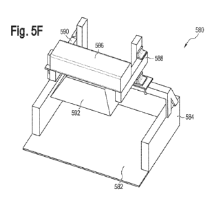
[0018] FIG. 5F illustrates an example apparatus by which video imagery
that may be
used by the example computer system may be captured.
[0019] FIG. 6A illustrates a flow of a programmed process by which the
example
computer system maps product data to picking area data, which can be used by
other
apparatus with which the system may interoperate.
[0020] FIG. 6B depicts an example of plots that may be generated by a
peak/valley
identification process.
[0021] FIG. 6C depicts an example of plots that may be generated by
peak/valley
identification process.
-2-
CA 03188650 2022-12-29
WO 2022/015944
PCT/US2021/041770
[0022] FIG. 6D depicts an example visualization of the generation of a
yield map
using the methods and systems described herein.
[0023] FIG. 6E depicts an example of a yield map in which differences in
product
yield are identified in picking areas, and the picking area yields are
overlaid on a digital
image of the field that also shows the tracking, across the field, of an
agricultural apparatus
carrying the video camera that captured imagery of the instances of
horticultural product used
to produce the yield data, as they were harvested.
[0024] FIG. 7A depicts an example of a yield map in which differences in
raw
product yield, a simple count of aggregate product count per picking area, are
identified in
picking areas, and the picking area yields are plotted by longitude and
latitude.
[0025] FIG. 7B depicts an example of a yield map in which differences in
yield per
acre are identified in picking areas, and the picking area yields are plotted
by longitude and
latitude.
DETAILED DESCRIPTION
[0026] In the following description, for the purposes of explanation,
numerous
specific details are set forth in order to provide a thorough understanding of
the present
disclosure. It will be apparent, however, that embodiments may be practiced
without these
specific details. In other instances, well-known structures and devices are
shown in block
diagram form in order to avoid unnecessarily obscuring the present disclosure.
Embodiments
are disclosed in sections according to the following outline:
1. GENERAL OVERVIEW
2. EXAMPLE COMPUTER SYSTEM
2.1. STRUCTURAL OVERVIEW
2.2. APPLICATION PROGRAM OVERVIEW
2.3. HARDWARE OVERVIEW
3. EXAMPLE ¨ COMPUTER VISION-BASED MODEL
4. EXAMPLE ¨ YIELD MONITORING PROCESS
4.1. PROCESS OVERVIEW
4.2. HORTICULTURAL PRODUCT DETECTION EXAMPLES
4.3. YIELD TO PICKING AREA MAPPING PROCESS
4.4. YIELD MAP EXAMPLES
5. ADDITIONAL EXAMPLES
6. BENEFITS, EXTENSIONS AND ALTERNATIVES
-3-
CA 03188650 2022-12-29
WO 2022/015944
PCT/US2021/041770
[0027] 1. GENERAL OVERVIEW
[0028] This disclosure describes technologies that enable yield
information to be
determined from video of horticultural products. Using the disclosed
technologies, yield can
be monitored and mapped to particular picking areas within a field at harvest
time.
[0029] Embodiments of the disclosed technologies utilize video imagery
that contains
instances of horticultural product. In an embodiment, in an harvesting
apparatus, an image
sensor has been arranged to capture digital imagery of instances of a
horticultural product
after the product has been picked from the field and placed in transit from
the picking area
via one or more conveyor belts to a harvester bin that is coupled to a vehicle
that can haul the
products in the harvester bin away. Instances of the horticultural product are
transported
from the picking area to the harvester bin via belt-assisted technology. For
example, instances
of the horticultural product may be picked and transferred to a conveyor belt,
which
transports the product to the harvester bin.
[0030] The video imagery captured during the picking area-to-bin transport
of the
horticultural product is input into a machine-learned model that has been
trained to recognize
instances of the horticultural product in video imagery. The machine-learned
model outputs
digital annotation data, digital geographic location data, and digital
timestamp data. The
digital annotation data is indicative of individual instances of the
horticultural product
detected in frames of the video imagery by the machine-learned model. The
digital
geographic location data corresponds to data that has been obtained via a
sensor that sensed
geographic locations at which the video imagery was captured. The digital
timestamp data is
indicative of timestamps associated with frames of the video imagery.
[0031] The annotated video data is used to compute quantitative data
and/or
qualitative data about the individual instances of the horticultural product
detected in the
video imagery. For example, embodiments count the number of individual
instances of
horticultural product detected in the video imagery. Alternatively or in
addition,
embodiments use the annotated video data to calculate the sizes of, and/or
determine one or
more other characteristics of individual instances of horticultural product
detected in the
video imagery, as described in more detail below.
[0032] A digital yield map can be output in a form of electronic
communication that
is capable of being used by a device to control an agricultural operation. For
example, yield
map data produced by the disclosed technologies may be used to determine or
modify a route
that a harvester or other implement uses to traverse a field, or cause the
machine to follow a
-4-
CA 03188650 2022-12-29
WO 2022/015944
PCT/US2021/041770
route that has been determined using the disclosed technologies. In an
embodiment, yield
map data includes location points, such as longitude and latitude coordinates,
centroid points,
etc. which are used to generate navigation instructions of a ground vehicle
moving through
the field, such as a harvester, a sprayer or a fertilizer applicator, or an
aerial vehicle flying
above the field, such as a drone. For instance, yield map location points that
represent regions
of particularly low yield or particularly high yield may be transformed into
waypoints of a
route for a vehicle.
[0033] The vehicle route as determined or modified by the yield data
produced by the
disclosed technologies is transmitted to a vehicle computer, such as a cab
computer of a
tractor pulling an implement or an embedded controller that controls
operations of the
implement, and the vehicle computer operates the implement along the route
that has been
determined or modified by the yield data produced by the disclosed
technologies.
[0034] In another embodiment, location points extracted from yield map
data
produced by the disclosed technologies, such as centroid points of data
representing regions
of high yield, are transformed into a route to be traversed by trucks or bins
to receive
harvested products so that adequate bin or truck capacity is available at high-
yield positions.
In still another embodiment, location points extracted from yield map data
produced by the
disclosed technologies, such as centroid points of data representing regions
of very low yield
or no yield, are excluded from a route to be traversed by trucks or bins, in
order to improve
efficiency of the operation by causing the vehicle to avoid very low yield and
no yield
positions.
[0035] In these and other examples, the yield map data produced by the
disclosed
technologies is used to determine or modify one or more operating parameters
of the
harvester or other implement. Examples of operating parameters include speed,
direction,
date/time of operation, number, type, or configuration of bins; number, type,
or configuration
of conveyor belts. Location points extracted from yield map data produced by
the disclosed
technologies may, alternatively or in addition, be used to control the speed
at which a vehicle
traverses the route. Vehicle speed may be increased through location points of
very low or no
yield, and the vehicle speed may be decreased through locations of high yield.
[0036] For example, the centroids of data associated with high-yield
locations may be
used in a speed control program to instruct a harvester, tractor or other
machine to reduce
speed when high-yield locations are reached to ensure adequate capture of
products during
harvesting.
-5-
CA 03188650 2022-12-29
WO 2022/015944
PCT/US2021/041770
[0037] In some embodiments, yield map data produced by the disclosed
technologies
is used to define management zones and/or to determine a prescription for
application of
nutrients or fertilizer to a field. Examples of uses of yield data to produce
management zones
and fertilizer application rates are described in U.S. Patent Nos. 10,398,096;
U.S. 10,667,474;
and U520160180473, each of which is incorporated herein by this reference.
[0038] Field as used herein may refer to a bounded tract of land, which
may be
defined by a set of acres. Field location as used herein may refer to a
particular location or
sub-area of a field. Picking area as used herein may refer to a field location
or more
specifically, a field location in which at least one instance of horticultural
product was
harvested. Product as used herein may refer to a horticultural product, such
as a fruit or
vegetable. Horticultural operation, as used herein, may refer to operations
conducted on one
or multiple fields, which may or may not be contiguous, in which horticultural
products may
be planted or harvested.
[0039] 2. EXAMPLE COMPUTER SYSTEM
[0040] 2.1 STRUCTURAL OVERVIEW
[0041] FIG. 1 illustrates an example computer system that is configured to
perform
the functions described herein, with a portion of the computer system shown in
a field
environment with other apparatus with which the system may interoperate. In
one
embodiment, a user 102 owns, operates, or possesses a computing device 104.
The
computing device 104 is programmed or configured to provide field data 106
and/or control
signals to a computer system 130 and/or to receive field data 106 and/or
control signals from
computer system 130, via one or more networks 109.
[0042] Examples of field data 106 include (a) identification data (for
example,
acreage, field name, field identifiers, geographic identifiers, boundary
identifiers, crop
identifiers, and any other suitable data that may be used to identify farm
land, such as a
common land unit (CLU), lot and block number, a parcel number, geographic
coordinates
and boundaries, Farm Serial Number (FSN), farm number, tract number, field
number,
section, township, and/or range), (b) harvest data (for example, crop type,
crop variety, crop
rotation, whether the crop is grown organically, harvest date, Actual
Production History
(APH), expected yield, yield, crop price, crop revenue, grain moisture,
tillage practice, and
previous growing season information), (c) soil data (for example, type,
composition, pH,
organic matter (OM), cation exchange capacity (CEC)), (d) planting data (for
example,
planting date, seed(s) type, relative maturity (RM) of planted seed(s), seed
population), (e)
fertilizer data (for example, nutrient type (Nitrogen, Phosphorous,
Potassium), application
-6-
CA 03188650 2022-12-29
WO 2022/015944
PCT/US2021/041770
type, application date, amount, source, method), (f) chemical application data
(for example,
pesticide, herbicide, fungicide, other substance or mixture of substances
intended for use as a
plant regulator, defoliant, or desiccant, application date, amount, source,
method), (g)
irrigation data (for example, application date, amount, source, method), (h)
weather data (for
example, precipitation, rainfall rate, predicted rainfall, water runoff rate
region, temperature,
wind, forecast, pressure, visibility, clouds, heat index, dew point, humidity,
snow depth, air
quality, sunrise, sunset), (i) imagery data (for example, imagery and light
spectrum
information from an agricultural apparatus sensor, camera, computer,
smartphone, tablet,
unmanned aerial vehicle (UAV), planes or satellite), (j) scouting observations
(photos,
videos, free form notes, voice recordings, voice transcriptions, weather
conditions
(temperature, precipitation (current and over time), soil moisture, crop
growth stage, wind
velocity, relative humidity, dew point, black layer)), and (k) soil, seed,
crop phenology, pest
and disease reporting, and predictions sources and databases. In some
embodiments, field
data 106 includes imagery, such as still or video digital imagery. Field data
106 may include
raw measured, detected, or sensed data values and/or data values that have
been computed
using raw data values, and may include estimates and predicted data values.
[0043] A data server computer 108 is communicatively coupled to computer
system
130 and is programmed or configured to send external data 110 to computer
system 130 via
the network(s) 109. The data server computer 108 may be owned or operated by
the same
legal person or entity as the computer system 130, or by a different person or
entity such as a
government agency, non-governmental organization (NGO), and/or a private data
service
provider. Examples of external data include weather data, imagery data, soil
data, or
statistical data relating to crop yields, among others. External data 110 may
consist of the
same type of information as field data 106. In some embodiments, the external
data 110 is
provided by an external data server computer 108 owned by the same entity that
owns and/or
operates the computer system 130. For example, the computer system 130 may
include a data
server focused exclusively on a type of data that might otherwise be obtained
from third party
sources, such as weather data. In some embodiments, an external data server
computer 108
may be incorporated within the system 130.
[0044] In an embodiment, external data server computer 108 stores external
data 110,
including soil data representing soil composition for the one or more fields
and weather data
representing temperature and precipitation on the one or more fields. The
weather data may
include past and present weather data as well as forecasts for future weather
data. In an
embodiment, external data server computer 108 comprises a plurality of servers
hosted by
-7-
CA 03188650 2022-12-29
WO 2022/015944
PCT/US2021/041770
different entities. For example, a first server may contain soil composition
data while a
second server may include weather data. Additionally, soil composition data
may be stored in
multiple servers. For example, one server may store data representing
percentage of sand, silt,
and clay in the soil while a second server may store data representing
percentage of organic
matter (OM) in the soil.
[0045] A device 111 may have one or more remote sensors 112 fixed thereon
or
coupled thereto, which sensors are communicatively coupled either directly or
indirectly via
device 111 to the computer system 130 and are programmed or configured to send
sensor
data to computer system 130. Examples of device 111 include tractors,
combines, harvesters,
conveyor belts, planters, trucks, fertilizer equipment, aerial vehicles
including unmanned
aerial vehicles, and any other item of physical machinery or hardware,
typically mobile
machinery, and which may be used in tasks associated with horticultural
operations. In some
embodiments, a single unit of device 111 may comprise a plurality of sensors
112 that are
coupled locally in a network on the apparatus; controller area network (CAN)
is example of
such a network that can be installed in combines, harvesters, sprayers, and
cultivators. In
some embodiments, remote sensors 112 may not be fixed to a device 111 but may
be
remotely located in the field and may communicate with network 109. Sensor
data may
include the same type of information as field data 106.
[0046] The device 111 may include an imaging system 115. The imaging
system 115
may be programmed or configured to receive, process, and store imagery data
(for example,
video imagery captured by the sensor(s) 112, camera, computer, smartphone,
tablet,
unmanned aerial vehicle, planes, or satellite). A portion of imaging system
115 may be
located on the device 111 and another portion of imaging system 115 may be
located at
another site. Data communication between the two portions may be provided by a
telemetry
system including a digital data link established by the site with the device
111. The digital
data link and/or telemetry system may be programmed or configured for real-
time data
communication. In an embodiment, device 111 is a harvester apparatus that
includes a
conveyor belt and harvester bin, and imaging system 115 is programmed or
configured to
produce and store video imagery generated by at least one sensor 112. In an
embodiment, the
sensor(s) that produce the video imagery include or are in communication with
a global
positioning system (GPS) component, which automatically produces geographic
location data
and correlates the geographic location data with the video imagery.
[0047] In an embodiment, remote sensor 112 comprises one or more sensors
that are
programmed or configured to produce one or more observations. Remote sensor
112 may be
-8-
CA 03188650 2022-12-29
WO 2022/015944
PCT/US2021/041770
a video camera, aerial sensors, such as satellites, vehicle sensors, planting
equipment sensors,
tillage sensors, fertilizer or insecticide application sensors, harvester
sensors, and any other
implement capable of capturing or receiving data from the one or more fields.
In an
embodiment, application controller 114 is programmed or configured to receive
instructions
from computer system 130. Application controller 114 may also be programmed or
configured to control an operating parameter of an agricultural vehicle or
implement. For
example, an application controller 114 may be programmed or configured to
control an
operating parameter of a vehicle, such as a tractor, planting equipment,
tillage equipment,
fertilizer or insecticide equipment, harvester equipment, or other farm
implements such as a
water valve. Other embodiments may use any combination of sensors and
controllers, of
which the following are merely selected examples.
[0048] The system 130 may obtain or ingest data under user 102 control, on
a mass
basis from a large number of growers who have contributed data to a shared
database system.
This form of obtaining data may be termed "manual data ingest" as one or more
user-
controlled computer operations are requested or triggered to obtain data for
use by the system
130. As an example, the CLIMATE FIELDVIEW application, commercially available
from
The Climate Corporation, San Francisco, California, may be operated to export
data to
system 130 for storing in the repository 160.
[0049] For example, yield monitor systems may contain yield sensors for
harvester
apparatus that send yield measurement data to the computer 116 or other
devices within the
system 130. Yield monitor systems may utilize one or more remote sensors 112
to obtain, for
example, moisture measurements in a combine or other harvester and transmit
these
measurements to the user via the computer 116 or other devices within the
system 130.
[0050] In an embodiment, examples of sensors 112 that may be used with any
moving
vehicle or apparatus of the type described elsewhere herein include kinematic
sensors and
position sensors. Kinematic sensors may comprise any of speed sensors such as
radar or
wheel speed sensors, accelerometers, or gyros. Position sensors may comprise
GPS receivers
or transceivers, or WiFi-based position or mapping apps that are programmed to
determine
location based upon nearby WiFi hotspots, among others.
[0051] In an embodiment, examples of sensors 112 that may be used with
tractors or
other moving vehicles include engine speed sensors, fuel consumption sensors,
area counters
or distance counters that interact with GPS or radar signals, PTO (power take-
off) speed
sensors, tractor hydraulics sensors configured to detect hydraulics parameters
such as
pressure or flow, and/or and hydraulic pump speed, wheel speed sensors or
wheel slippage
-9-
CA 03188650 2022-12-29
WO 2022/015944
PCT/US2021/041770
sensors. In an embodiment, examples of controllers 114 that may be used with
tractors
include hydraulic directional controllers, pressure controllers, and/or flow
controllers;
hydraulic pump speed controllers; speed controllers or governors; hitch
position controllers;
or wheel position controllers provide automatic steering.
[0052] In an embodiment, examples of sensors 112 that may be used with
seed
planting equipment such as planters, drills, or air seeders include seed
sensors, which may be
optical, electromagnetic, or impact sensors; downforce sensors such as load
pins, load cells,
pressure sensors; soil property sensors such as reflectivity sensors, moisture
sensors,
electrical conductivity sensors, optical residue sensors, or temperature
sensors; component
operating criteria sensors such as planting depth sensors, downforce cylinder
pressure
sensors, seed disc speed sensors, seed drive motor encoders, seed conveyor
system speed
sensors, or vacuum level sensors; or pesticide application sensors such as
optical or other
electromagnetic sensors, or impact sensors. In an embodiment, examples of
controllers 114
that may be used with such seed planting equipment include: toolbar fold
controllers, such as
controllers for valves associated with hydraulic cylinders; downforce
controllers, such as
controllers for valves associated with pneumatic cylinders, airbags, or
hydraulic cylinders,
and programmed for applying downforce to individual row units or an entire
planter frame;
planting depth controllers, such as linear actuators; metering controllers,
such as electric seed
meter drive motors, hydraulic seed meter drive motors, or swath control
clutches; hybrid
selection controllers, such as seed meter drive motors, or other actuators
programmed for
selectively allowing or preventing seed or an air-seed mixture from delivering
seed to or from
seed meters or central bulk hoppers; metering controllers, such as electric
seed meter drive
motors, or hydraulic seed meter drive motors; seed conveyor system
controllers, such as
controllers for a belt seed delivery conveyor motor; marker controllers, such
as a controller
for a pneumatic or hydraulic actuator; or pesticide application rate
controllers, such as
metering drive controllers, orifice size or position controllers.
[0053] In an embodiment, examples of sensors 112 that may be used with
tillage
equipment include position sensors for tools such as shanks or discs; tool
position sensors for
such tools that are configured to detect depth, gang angle, or lateral
spacing; downforce
sensors; or draft force sensors. In an embodiment, examples of controllers 114
that may be
used with tillage equipment include downforce controllers or tool position
controllers, such
as controllers configured to control tool depth, gang angle, or lateral
spacing.
[0054] In an embodiment, examples of sensors 112 that may be used in
relation to
apparatus for applying fertilizer, insecticide, fungicide and the like, such
as on-planter starter
-10-
CA 03188650 2022-12-29
WO 2022/015944
PCT/US2021/041770
fertilizer systems, subsoil fertilizer applicators, or fertilizer sprayers,
include: fluid system
criteria sensors, such as flow sensors or pressure sensors; sensors indicating
which spray head
valves or fluid line valves are open; sensors associated with tanks, such as
fill level sensors;
sectional or system-wide supply line sensors, or row-specific supply line
sensors; or
kinematic sensors such as accelerometers disposed on sprayer booms. In an
embodiment,
examples of controllers 114 that may be used with such apparatus include pump
speed
controllers; valve controllers that are programmed to control pressure, flow,
direction, PWM
and the like; or position actuators, such as for boom height, subsoiler depth,
or boom
position.
[0055] In an embodiment, examples of sensors 112 that may be used with
harvesters
include yield monitors, such as impact plate strain gauges or position
sensors, capacitive flow
sensors, load sensors, weight sensors, or torque sensors associated with
elevators or augers,
or optical or other electromagnetic grain height sensors; grain moisture
sensors, such as
capacitive sensors; grain loss sensors, including impact, optical, or
capacitive sensors; header
operating criteria sensors such as header height, header type, deck plate gap,
feeder speed,
and reel speed sensors; separator operating criteria sensors, such as concave
clearance, rotor
speed, shoe clearance, or chaffer clearance sensors; auger sensors for
position, operation, or
speed; or engine speed sensors. In an embodiment, examples of controllers 114
that may be
used with harvesters include header operating criteria controllers for
elements such as header
height, header type, deck plate gap, feeder speed, or reel speed; separator
operating criteria
controllers for features such as concave clearance, rotor speed, shoe
clearance, or chaffer
clearance; or controllers for auger position, operation, or speed.
[0056] In an embodiment, examples of sensors 112 that may be used with
grain carts
include weight sensors, or sensors for auger position, operation, or speed. In
an embodiment,
examples of controllers 114 that may be used with grain carts include
controllers for auger
position, operation, or speed.
[0057] In an embodiment, examples of sensors 112 and controllers 114 may
be
installed on harvester equipment, such as a conveyor belt, in unmanned aerial
vehicle (UAV)
apparatus or "drones." Such sensors may include cameras with detectors
effective for any
range of the electromagnetic spectrum including visible light, infrared,
ultraviolet, near-
infrared (NIR), and the like; accelerometers; altimeters; temperature sensors;
humidity
sensors; pitot tube sensors or other airspeed or wind velocity sensors;
battery life sensors; or
radar emitters and reflected radar energy detection apparatus; other
electromagnetic radiation
emitters and reflected electromagnetic radiation detection apparatus. Such
controllers may
-11-
CA 03188650 2022-12-29
WO 2022/015944
PCT/US2021/041770
include guidance or motor control apparatus, control surface controllers,
camera controllers,
or controllers programmed to turn on, operate, obtain data from, manage, and
configure any
of the foregoing sensors.
[0058] An apparatus 117 may include one or more tractors, combines,
harvesters,
planters, trucks, fertilizer equipment, aerial vehicles including unmanned
aerial vehicles, and
any other item of physical machinery or hardware, typically mobile machinery,
and which
may be used in tasks associated with horticulture and/or other farming
operations. The
apparatus 117 may comprise or be coupled to a computer 116 that is programmed
with a
software application, which may comprise a version or variant of the software
application for
device 104 that is further described in other sections herein. In an
embodiment, computer 116
comprises a compact computer, often a tablet-sized computer or smartphone,
with a graphical
screen display, such as a color display, that is mounted within an operator's
cab of the
apparatus 117. Computer 116 may implement some or all of the operations and
functions that
are described further herein for the computing device 104.
[0059] Application controller 114 is communicatively coupled to computer
system
130 via the network(s) 109 and is programmed or configured to receive one or
more scripts
that are used to control an operating parameter of a device, vehicle or
implement, such as
computing device 104, apparatus 117 or device 111, from the computer system
130. For
instance, a controller area network (CAN) bus interface may be used to enable
communications from the computer system 130 to the computer 116 via the
network(s) 109.
The network(s) 109 may be used to enable communications from the imaging
system 115 to
the computer system 130, from the computer system 130 to the imaging system
115, from the
computer system 130 to the computing device 104, from the computing device 104
to the
computer system 130.
[0060] The network(s) 109 broadly represent any combination of one or more
data
communication networks including local area networks, wide area networks,
internetworks,
or internets, using any of wireline or wireless links, including terrestrial
or satellite links. The
network(s) may be implemented by any medium or mechanism that provides for the
exchange of data between the various elements of FIG. 1. The various elements
of FIG. 1
may also have direct (wired or wireless) communications links. The sensors
112, controller
114, external data server computer 108, and other elements of the system each
comprise an
interface compatible with the network(s) 109 and are programmed or configured
to use
standardized protocols for communication across the networks such as TCP/IP,
Bluetooth,
CAN protocol and higher-layer protocols such as HTTP, TLS, and the like.
-12-
CA 03188650 2022-12-29
WO 2022/015944
PCT/US2021/041770
[0061] Computer system 130 is programmed or configured to receive field
data 106
from computing device 104, external data 110 from external data server
computer 108, sensor
data from remote sensor 112, and/or imagery data from imaging system 115.
Computer
system 130 may be further configured to host, use or execute one or more
computer
programs, other software elements, digitally programmed logic such as FPGAs or
ASICs, or
any combination thereof to perform translation and storage of data values,
construction of
digital models of one or more crops on one or more fields, generation of
recommendations
and notifications, and generation and sending of scripts to application
controller 114, in the
manner described further in other sections of this disclosure.
[0062] In an embodiment, computer system 130 is programmed with or
comprises a
communication layer 132, a presentation layer 134, a data management layer
140, a
hardware/virtualization layer 150, and a model and field data repository 160.
"Layer," in this
context, refers to any combination of computer hardware and/or software, such
as electronic
digital interface circuits, microcontrollers, firmware such as drivers, and/or
computer
programs or other software elements.
[0063] Communication layer 132 may be programmed or configured to perform
input/output interfacing functions including sending requests to computing
device 104,
computer 116, imaging system 115, external data server computer 108, and
remote sensor
112 for field data, external data, and/or sensor data. Communication layer 132
may be
programmed or configured to send the received data to model and field data
repository 160 to
be stored as field data 106.
[0064] Presentation layer 134 may be programmed or configured to generate
a
graphical user interface (GUI) to be displayed on computing device 104,
computer 116 or
other computers that are coupled to the system 130 through the network(s) 109.
The GUI may
comprise controls for inputting data to be sent to computer system 130,
generating requests
for models and/or recommendations, and/or displaying recommendations,
notifications,
models, and other field data.
[0065] Data management layer 140 may be programmed or configured to manage
read operations and write operations involving the model and repository 160
and other
functional elements of the system, including queries and result sets
communicated between
the functional elements of the system and the repository. Examples of data
management layer
140 include JDBC, SQL server interface code, and/or HADOOP interface code,
among
others. Repository 160 may comprise a database; for example, a database in
which model
parameters and weights are stored. As used herein, the term "database" may
refer to either a
-13-
CA 03188650 2022-12-29
WO 2022/015944
PCT/US2021/041770
body of data, a relational database management system (RDBMS), or to both. As
used herein,
a database may comprise any collection of data including hierarchical
databases, relational
databases, flat file databases, object-relational databases, object oriented
databases,
distributed databases, and any other structured collection of records or data
that is stored in a
computer system. Examples of RDBMS's include, but are not limited to
including,
ORACLE , MYSQL, IBM DB2, MICROSOFT SQL SERVER, SYBASEO, and
POSTGRESQL databases. However, any database may be used that enables the
systems and
methods described herein.
[0066] When field data 106 is not provided directly to the computer system
130 via a
device 111, remote sensor 112, computing device 104, or computer 116, the user
may be
prompted via one or more user interfaces on the user device (served by the
computer system
130) to input such information. In an example embodiment, the user may specify
identification data by accessing a map on the user device (served by the
computer system
130) and selecting specific common land units (CLUs) or contiguous farming
parcels that
have been graphically shown on the map. In an alternative embodiment, the user
102 may
specify identification data by accessing a map on the user device (served by
the computer
system 130) and drawing boundaries of the field over the map. Such CLU
selection or map
drawings represent geographic identifiers. In alternative embodiments, the
user may specify
identification data by accessing field identification data (provided as shape
files or in a
similar format) from the U. S. Department of Agriculture Farm Service Agency
or other
source via the user device and providing such field identification data to the
computer system
130.
[0067] In an example embodiment, the computer system 130 is programmed to
generate and cause displaying a graphical user interface comprising a data
manager for data
input. After one or more fields have been identified using the methods
described above, the
data manager may provide one or more graphical user interface widgets which
when selected
can identify changes to the field, soil, crops, tillage, or nutrient
practices. The data manager
may include a timeline view, a spreadsheet view, and/or one or more editable
programs.
[0068] In an embodiment, yield monitor instructions 136 comprises a set of
one or
more pages of main memory, such as RAM, in the computer system 130 into which
executable instructions have been loaded and which when executed cause the
computing
system 130 to perform the functions or operations that are described herein
with reference to
those instructions. For example, yield monitor instructions 136 may comprise a
set of pages
in RAM that contain instructions which when executed cause performing the
yield prediction
-14-
CA 03188650 2022-12-29
WO 2022/015944
PCT/US2021/041770
functions that are described herein with reference to FIGS. 4 and 5. The
instructions may be
in machine executable code in the instruction set of a CPU and may have been
compiled
based upon source code written in JAVA, C, C++, OBJECTIVE-C, or any other
human-
readable programming language or environment, alone or in combination with
scripts in
JAVASCRIPT, other scripting languages and other programming source text. The
term
"pages" is intended to refer broadly to any region within main memory and the
specific
terminology used in a system may vary depending on the memory architecture or
processor
architecture. In another embodiment, yield monitor instructions 136 also may
represent one
or more files or projects of source code that are digitally stored in a mass
storage device such
as non-volatile RAM or disk storage, in the computer system 130 or a separate
repository
system, which when compiled or interpreted cause generating executable
instructions which
when executed cause the agricultural intelligence computing system to perform
the functions
or operations that are described herein with reference to those modules. In
other words, the
drawing figures may represent the manner in which programmers or software
developers
organize and arrange source code for later compilation into an executable, or
interpretation
into bytecode or the equivalent, for execution by the computer system 130.
[0069] Hardware/virtualization layer 150 comprises one or more central
processing
units (CPUs), memory controllers, and other devices, components, or elements
of a computer
system such as volatile or non-volatile memory, non-volatile storage such as
disPlk, and I/O
devices or interfaces. The layer 150 also may comprise programmed instructions
that are
configured to support virtualization, containerization, or other technologies.
[0070] For purposes of illustrating a clear example, FIG. 1 shows a
limited number of
instances of certain functional elements. However, in other embodiments, there
may be any
number of such elements. For example, embodiments may use thousands or
millions of
different computing devices 104 associated with different users. Further, the
system 130
and/or external data server computer 108 may be implemented using two or more
processors,
cores, clusters, or instances of physical machines or virtual machines,
configured in a discrete
location, or co-located with other elements in a datacenter, shared computing
facility or cloud
computing facility.
[0071] 2.2. APPLICATION PROGRAM OVERVIEW
[0072] In an embodiment, the implementation of the functions described
herein using
one or more computer programs or other software elements that are loaded into
and executed
using one or more general-purpose computers will cause the general-purpose
computers to be
configured as a particular machine or as a computer that is specially adapted
to perform the
-15-
CA 03188650 2022-12-29
WO 2022/015944
PCT/US2021/041770
functions described herein. Further, each of the flow diagrams that are
described further
herein may serve, alone or in combination with the descriptions of processes
and functions in
prose herein, as instructions, plans or directions that may be used to program
a computer or
logic to implement the functions that are described. In other words, all the
prose text herein,
and all the drawing figures, together are intended to provide disclosure of
instructions, plans
or directions that are sufficient to permit a skilled person to program a
computer to perform
the functions that are described herein, in combination with the skill and
knowledge of such a
person given the level of skill that is appropriate for inventions and
disclosures of this type.
[0073] In an embodiment, user 102 interacts with computer system 130 using
computing device 104 configured with an operating system and one or more
application
programs or apps; the computing device 104 also may interoperate with the
computer system
130 independently and automatically under program control or logical control
and direct user
interaction is not always required. Computing device 104 broadly represents
one or more of a
smart phone, PDA, tablet computing device, laptop computer, desktop computer,
workstation, or any other computing device capable of transmitting and
receiving information
and performing the functions described herein. Computing device 104 may
communicate via
a network using a software application, such as a mobile device application,
stored on
computing device 104, and in some embodiments, the device may be coupled using
a cable
113 or connector to a sensor 112 and/or application controller 114. A
particular user 102 may
own, operate, or possess and use, in connection with system 130, more than one
computing
device 104 at a time.
[0074] The software application may provide client-side functionality, via
the
network to one or more mobile computing devices. In an example embodiment,
computing
device 104 may access the mobile application via a web browser or a local
client application
or app. Computing device 104 may transmit data to, and receive data from, one
or more
front-end servers, using web-based protocols or formats such as HTTP, XML
and/or JSON,
or app-specific protocols. In an example embodiment, the data may take the
form of requests
and user information input, such as field data, into the mobile computing
device. In some
embodiments, the mobile application interacts with location tracking hardware
and software
on computing device 104 which determines the location of computing device 104
using
standard tracking techniques such as multilateration of radio signals, the
global positioning
system (GPS), WiFi positioning systems, or other methods of mobile
positioning. In some
cases, location data or other data associated with the device 104, user 102,
and/or user
-16-
CA 03188650 2022-12-29
WO 2022/015944
PCT/US2021/041770
account(s) may be obtained by queries to an operating system of the device or
by requesting
an app on the device to obtain data from the operating system.
[0075] In an embodiment, computing device 104 sends field data 106 to
computer
system 130 comprising or including, but not limited to, data values
representing one or more
of: a geographical location of the one or more fields, tillage information for
the one or more
fields, imagery data and/or other data relating to crops planted in the one or
more fields, and
soil data extracted from the one or more fields. Computing device 104 may send
field data
106 in response to user input from user 102 specifying the data values for the
one or more
fields. Additionally, computing device 104 may automatically send field data
106 when one
or more of the data values becomes available to computing device 104. For
example,
computing device 104 may be communicatively coupled to imaging system 115 or
remote
sensor 112 and/or application controller 114. In response to receiving data
indicating that
application controller 114 has caused imaging system 115 to collect imagery
data of a field
location, computing device 104 may send field data 106 including the imagery
data for one or
more field locations to computing system 130. Field data 106 identified in
this disclosure
may be input and communicated using electronic digital data that is
communicated between
computing devices using parameterized URLs over HTTP, or another suitable
communication or messaging protocol. Portions of the description of the
software application
with respect to operations of computing device 104 are alternatively or in
addition applicable
to computer 116 and/or portions of imaging system 115.
[0076] A commercial example of a software application portions of which
may be
implemented on computing device 104 or computer 116 is CLIMATE FIELDVIEW,
commercially available from The Climate Corporation, San Francisco,
California. The
CLIMATE FIELDVIEW application, or other applications, may be modified,
extended, or
adapted to include features, functions, and programming that have not been
disclosed earlier
than the filing date of this disclosure. In one embodiment, the software
application comprises
an integrated software platform that allows a user, such as a grower, to make
fact-based
decisions for a horticultural operation because it combines historical data
about the grower's
fields with any other data that the grower wishes to compare. The combinations
and
comparisons may be performed in real time and are based upon scientific models
that provide
potential scenarios to permit the grower to make better, more informed
decisions.
[0077] FIG. 2A and FIG. 2B illustrate two views of an example logical
organization
of sets of instructions in main memory when an example mobile application is
loaded for
execution. In FIG. 2A and FIG. 2B, each named element represents a region of
one or more
-17-
CA 03188650 2022-12-29
WO 2022/015944
PCT/US2021/041770
pages of RAM or other main memory, or one or more blocks of disk storage or
other non-
volatile storage, and the programmed instructions within those regions. In one
embodiment,
in FIG. 2A, a mobile computer application 200 comprises account-fields-data
ingestion-
sharing instructions 202, overview and alert instructions 204, digital map
book instructions
206, seeds and planting instructions 208, nitrogen instructions 210, weather
instructions 212,
field health instructions 214, and performance instructions 216.
[0078] In one embodiment, a mobile computer application 200 comprises
account,
fields, data ingestion, sharing instructions 202 which are programmed to
receive, translate,
and ingest field data from sensors 112, imaging system 115, external data 110,
or third party
systems via manual upload or APIs. Data types may include field boundaries,
yield maps, as-
planted maps, soil test results, as-applied maps, and/or management zones,
among others.
Data formats may include shape files, native data formats of third parties,
image files, and/or
farm management information system (FMIS) exports, among others. Receiving
data may
occur via manual upload, e-mail with attachment, external APIs that push data
to the mobile
application, or instructions that call APIs of external systems to pull data
into the mobile
application. In one embodiment, mobile computer application 200 comprises a
data inbox. In
response to receiving a selection of the data inbox, the mobile computer
application 200 may
display a graphical user interface for manually uploading data files and
importing uploaded
files to a data manager.
[0079] In one embodiment, digital map book instructions 206 comprise field
map data
layers stored in device memory and are programmed with data visualization
tools and
geospatial field notes. This provides users with convenient information close
at hand for
reference, logging, and visual insights into field performance. In one
embodiment, overview
and alert instructions 204 are programmed to provide an operation-wide view of
what is
important to the user, and timely recommendations to take action or focus on
particular
issues. This permits the user to focus time on what needs attention, to save
time and preserve
yield throughout the season. In one embodiment, seeds and planting
instructions 208 are
programmed to provide tools for seed selection, hybrid placement, harvesting,
and script
creation, including variable rate (VR) script creation, based upon scientific
models and
empirical data. This enables growers to maximize yield or return on investment
through
optimized seed purchase, placement, population, and harvesting.
[0080] In one embodiment, script generation instructions 205 are
programmed to
provide an interface for generating scripts, including variable rate (VR)
fertility scripts. The
interface enables the creation of scripts for field implements, such as
nutrient applications,
-18-
CA 03188650 2022-12-29
WO 2022/015944
PCT/US2021/041770
planting, harvesting, and irrigation. For example, a planting script interface
may comprise
tools for identifying a type of seed for planting. Upon receiving a selection
of the seed type,
mobile computer application 200 may display one or more fields broken into
management
zones, such as the field map data layers created as part of digital map book
instructions 206.
In one embodiment, the management zones comprise soil zones along with a panel
identifying each soil zone and a soil name, texture, drainage for each zone,
or other field data.
Mobile computer application 200 may also display tools for editing or creating
such, such as
graphical tools for drawing management zones, such as soil zones, over a map
of one or more
fields. Planting procedures may be applied to all management zones or
different planting
procedures may be applied to different subsets of management zones. When a
script is
created, mobile computer application 200 may make the script available for
download in a
format readable by an application controller, such as an archived or
compressed format.
Additionally, and/or alternatively, a script may be sent directly to computer
116 from mobile
computer application 200 and/or uploaded to one or more data servers and
stored for further
use.
[0081] In one embodiment, nitrogen instructions 210 are programmed to
provide
tools to inform nitrogen decisions by visualizing the availability of nitrogen
to crops. This
enables growers to maximize yield or return on investment through optimized
nitrogen
application during the season. Example programmed functions include displaying
images
such as SSURGO images to enable drawing of fertilizer application zones and/or
images
generated from subfield soil data, such as data obtained from sensors, at a
high spatial
resolution (as fine as millimeters or smaller depending on sensor proximity
and resolution);
upload of existing grower-defined zones; providing a graph of plant nutrient
availability
and/or a map to enable tuning application(s) of nitrogen across multiple
zones; output of
scripts to drive machinery; tools for mass data entry and adjustment; and/or
maps for data
visualization, among others. "Mass data entry," in this context, may mean
entering data once
and then applying the same data to multiple fields and/or zones that have been
defined in the
system; example data may include nitrogen application data that is the same
for many fields
and/or zones of the same grower, but such mass data entry applies to the entry
of any type of
field data into the mobile computer application 200. For example, nitrogen
instructions 210
may be programmed to accept definitions of nitrogen application and practices
programs and
to accept user input specifying to apply those programs across multiple
fields. "Nitrogen
application programs," in this context, refers to stored, named sets of data
that associates: a
name, color code or other identifier, one or more dates of application, types
of material or
-19-
CA 03188650 2022-12-29
WO 2022/015944
PCT/US2021/041770
product for each of the dates and amounts, method of application or
incorporation such as
injected or broadcast, and/or amounts or rates of application for each of the
dates, crop or
hybrid that is the subject of the application, among others. "Nitrogen
practices programs," in
this context, refer to stored, named sets of data that associates: a practices
name; a previous
crop; a tillage system; a date of primarily tillage; one or more previous
tillage systems that
were used; one or more indicators of application type, such as manure, that
were used.
Nitrogen instructions 210 also may be programmed to generate and cause
displaying a
nitrogen graph, which indicates projections of plant use of the specified
nitrogen and whether
a surplus or shortfall is predicted; in some embodiments, different color
indicators may signal
a magnitude of surplus or magnitude of shortfall. In one embodiment, a
nitrogen graph
comprises a graphical display in a computer display device comprising a
plurality of rows,
each row associated with and identifying a field; data specifying what crop is
planted in the
field, the field size, the field location, and a graphic representation of the
field perimeter; in
each row, a timeline by month with graphic indicators specifying each nitrogen
application
and amount at points correlated to month names; and numeric and/or colored
indicators of
surplus or shortfall, in which color indicates magnitude.
[0082] In one embodiment, the nitrogen graph may include one or more user
input
features, such as dials or slider bars, to dynamically change the nitrogen
planting and
practices programs so that a user may optimize his nitrogen graph. The user
may then use his
optimized nitrogen graph and the related nitrogen planting and practices
programs to
implement one or more scripts, including variable rate (VR) fertility scripts.
Nitrogen
instructions 210 also may be programmed to generate and cause displaying a
nitrogen map,
which indicates projections of plant use of the specified nitrogen and whether
a surplus or
shortfall is predicted; in some embodiments, different color indicators may
signal a
magnitude of surplus or magnitude of shortfall. The nitrogen map may display
projections of
plant use of the specified nitrogen and whether a surplus or shortfall is
predicted for different
times in the past and the future (such as daily, weekly, monthly, or yearly)
using numeric
and/or colored indicators of surplus or shortfall, in which color indicates
magnitude. In one
embodiment, the nitrogen map may include one or more user input features, such
as dials or
slider bars, to dynamically change the nitrogen planting and practices
programs so that a user
may optimize his nitrogen map, such as to obtain a preferred amount of surplus
to shortfall.
The user may then use his optimized nitrogen map and the related nitrogen
planting and
practices programs to implement one or more scripts, including variable rate
(VR) fertility
scripts. In other embodiments, similar instructions to the nitrogen
instructions 210 could be
-20-
CA 03188650 2022-12-29
WO 2022/015944
PCT/US2021/041770
used for application of other nutrients (such as phosphorus and potassium),
application of
pesticide, and irrigation programs.
[0083] In one embodiment, weather instructions 212 are programmed to
provide
field-specific recent weather data and forecasted weather information. This
enables growers
to save time and have an efficient integrated display with respect to daily
operational
decisions.
[0084] In one embodiment, field health instructions 214 are programmed to
provide
timely remote sensing images highlighting in-season crop variation and
potential concerns.
Example programmed functions include cloud checking, to identify possible
clouds or cloud
shadows; determining nitrogen indices based on field images; graphical
visualization of
scouting layers, including, for example, those related to field health, and
viewing and/or
sharing of scouting notes; downloading satellite images from multiple sources
and
prioritizing the images for the grower, graphical visualization of field
locations including
yield predictions generated from aerial imagery, among others. For example,
field health
instructions 214 may be programmed to provide pre-harvest recommendations or
harvesting
recommendations based on yield information produced from video imagery by
yield monitor
instructions 136.
[0085] In one embodiment, performance instructions 216 are programmed to
provide
reports, analysis, and insight tools using on-farm data for evaluation,
insights, and decisions.
This enables the grower to seek improved outcomes for the next year through
fact-based
conclusions about why return on investment was at prior levels, and insight
into yield-
limiting factors. The performance instructions 216 may be programmed to
communicate via
the network(s) 109 to back-end analytics programs executed at computer system
130 and/or
external data server computer 108 and configured to analyze metrics such as
yield, yield
differential, hybrid, population, SSURGO zone, soil test properties, or
elevation, among
others. Programmed reports and analysis may include yield variability
analysis, treatment
effect estimation, benchmarking of yield and other metrics against other
growers based on
anonymized data collected from many growers, or data for seeds, planting, or
harvesting,
among others.
[0086] Applications having instructions configured in this way may be
implemented
for different computing device platforms while retaining the same general user
interface
appearance. For example, the mobile application may be programmed for
execution on
tablets, smartphones, or server computers that are accessed using browsers at
client
computers. Further, the mobile application as configured for tablet computers
or smartphones
-21-
CA 03188650 2022-12-29
WO 2022/015944
PCT/US2021/041770
may provide a full app experience or a cab app experience that is suitable for
the display and
processing capabilities of computer 116.
[0087] For example, referring now to FIG. 2B, in one embodiment a cab
computer
application 220 may comprise maps-cab instructions 222, remote view
instructions 224, data
collect and transfer instructions 226, machine alerts instructions 228, script
transfer
instructions 230, and scouting-cab instructions 232. The code base for the
instructions of FIG.
2B may be the same as for FIG. 2A and executables implementing the code may be
programmed to detect the type of platform on which they are executing and to
expose,
through a graphical user interface, only those functions that are appropriate
to a cab platform
or full platform. This approach enables the system to recognize the distinctly
different user
experience that is appropriate for an in-cab environment and the different
technology
environment of the cab. The maps-cab instructions 222 may be programmed to
provide map
views of fields, farms or regions that are useful in directing machine
operation. The remote
view instructions 224 may be programmed to turn on, manage, and provide views
of machine
activity in real-time or near real-time to other computing devices connected
to the system 130
via wireless networks, wired connectors or adapters, and the like. The data
collect and
transfer instructions 226 may be programmed to turn on, manage, and provide
transfer of data
collected at sensors and controllers to the system 130 via wireless networks,
wired connectors
or adapters, and the like. The machine alerts instructions 228 may be
programmed to detect
issues with operations of the machine or tools that are associated with the
cab and generate
operator alerts. The script transfer instructions 230 may be configured to
transfer in scripts of
instructions that are configured to direct machine operations or the
collection of data. The
scouting-cab instructions 232 may be programmed to display location-based
alerts and
information received from the system 130 based on the location of the
computing device 104,
device 111, computer 116, or sensors 112 in the field and ingest, manage, and
provide
transfer of location-based scouting observations to the system 130 based on
the location of
the device 111 or sensors 112 in the field. In an embodiment, maps-cab
instructions 222 may
be programmed to provide map views of field locations that have been generated
using aerial
imagery produced by imaging system 115; remote view instructions 224 may be
programmed
to turn on, manage, and provide views of activity of the device 111 in real-
time or near real-
time to other computing devices connected to the system 130 via wireless
networks, wired
connectors or adapters, and the like; data collect and transfer instructions
226 may be
programmed to turn on, manage, and provide transfer of data collected at
sensors 112 or
imaging system 115 to the system 130 via wireless networks, wired connectors
or adapters,
-22-
CA 03188650 2022-12-29
WO 2022/015944
PCT/US2021/041770
and the like; machine alerts instructions 228 may be programmed to detect
issues with
operations of the device 111 or other machine or tools and generate operator
alerts; script
transfer instructions 230 may be configured to transfer in scripts of
instructions that are
configured to direct operations of device 111 or the collection of data by
imaging system 115;
scouting-cab instructions 232 may be programmed to display location-based
alerts and
information received from the system 130 including yield data produced by
yield monitor
instructions 136 for particular field locations, based on the location of the
computing device
104, device 111, computer 116, or sensors 112 in the field and ingest, manage,
and provide
transfer of location-based yield prediction data to the system 130 based on
the location of the
device 111 or sensors 112 in the field.
[0088] FIG. 2C depicts an example embodiment of a timeline view for data
entry.
Using the display depicted in FIG. 2C, a user computer can input a selection
of a particular
field and a particular date for the addition of event. Events depicted at the
top of the timeline
may include Nitrogen, Planting, Practices, and Soil. To add a nitrogen
application event, a
user computer may provide input to select the nitrogen tab. The user computer
may then
select a location on the timeline for a particular field in order to indicate
an application of
nitrogen on the selected field. In response to receiving a selection of a
location on the
timeline for a particular field, the data manager may display a data entry
overlay, allowing
the user computer to input data pertaining to nitrogen applications, planting
procedures, soil
application, tillage procedures, irrigation practices, or other information
relating to the
particular field. For example, if a user computer selects a portion of the
timeline and indicates
an application of nitrogen, then the data entry overlay may include fields for
inputting an
amount of nitrogen applied, a date of application, a type of fertilizer used,
and any other
information related to the application of nitrogen.
[0089] In an embodiment, the data manager provides an interface for
creating one or
more programs. "Program," in this context, refers to a set of data pertaining
to nitrogen
applications, planting procedures, soil application, tillage procedures,
irrigation practices, or
other information that may be related to one or more fields, and that can be
stored in digital
data storage for reuse as a set in other operations. After a program has been
created, it may be
conceptually applied to one or more fields and references to the program may
be stored in
digital storage in association with data identifying the fields. Thus, instead
of manually
entering identical data relating to the same nitrogen applications for
multiple different fields,
a user computer may create a program that indicates a particular application
of nitrogen and
then apply the program to multiple different fields. For example, in the
timeline view of FIG.
-23-
CA 03188650 2022-12-29
WO 2022/015944
PCT/US2021/041770
2C, the top two timelines have the "Spring applied" program selected, which
includes an
application of 150 lbs N/ac in early April. The data manager may provide an
interface for
editing a program. In an embodiment, when a particular program is edited, each
field that has
selected the particular program is edited. For example, in FIG. 2C, if the
"Spring applied"
program is edited to reduce the application of nitrogen to 130 lbs N/ac, the
top two fields may
be updated with a reduced application of nitrogen based on the edited program.
[0090] In an embodiment, in response to receiving edits to a field that
has a program
selected, the data manager removes the correspondence of the field to the
selected program.
For example, if a nitrogen application is added to the top field in FIG. 2C,
the interface may
update to indicate that the "Spring applied" program is no longer being
applied to the top
field. While the nitrogen application in early April may remain, updates to
the "Spring
applied" program would not alter the April application of nitrogen.
[0091] FIG. 2D depicts an example embodiment of a spreadsheet view for
data entry.
Using the display depicted in FIG. 2D, a user can create and edit information
for one or more
fields. The data manager may include spreadsheets for inputting information
with respect to
Nitrogen, Planting, Practices, and Soil as depicted in FIG. 2D. To edit a
particular entry, a
user computer may select the particular entry in the spreadsheet and update
the values. For
example, FIG. 2D depicts an in-progress update to a target yield value for the
second field.
Additionally, a user computer may select one or more fields in order to apply
one or more
programs. In response to receiving a selection of a program for a particular
field, the data
manager may automatically complete the entries for the particular field based
on the selected
program. As with the timeline view, the data manager may update the entries
for each field
associated with a particular program in response to receiving an update to the
program.
Additionally, the data manager may remove the correspondence of the selected
program to
the field in response to receiving an edit to one of the entries for the
field.
[0092] In an embodiment, model and field data is stored in model and field
data
repository 160. Model data comprises data models created for one or more
fields. For
example, a crop model may include a digitally constructed model of the
development of a
crop on the one or more fields. "Model," in this context, refers to an
electronic digitally
stored set of executable instructions and data values, associated with one
another, which are
capable of receiving and responding to a programmatic or other digital call,
invocation, or
request for resolution based upon specified input values, to yield one or more
stored or
calculated output values that can serve as the basis of computer-implemented
recommendations, output data displays, or machine control, among other things.
Persons of
-24-
CA 03188650 2022-12-29
WO 2022/015944
PCT/US2021/041770
skill in the field find it convenient to express models using mathematical
equations, but that
form of expression does not confine the models disclosed herein to abstract
concepts; instead,
each model herein has a practical application in a computer in the form of
stored executable
instructions and data that implement the model using the computer. The model
may include a
model of past events on the one or more fields, a model of the current status
of the one or
more fields, and/or a model of predicted events on the one or more fields.
Model and field
data may be stored in data structures in memory, rows in a database table, in
flat files or
spreadsheets, or other forms of stored digital data.
[0093] 2.3 HARDWARE OVERVIEW
[0094] According to one embodiment, the techniques described herein are
implemented by at least one special-purpose computing device. The special-
purpose
computing device may be hard-wired to perform the techniques, or may include
digital
electronic devices such as at least one application-specific integrated
circuit (ASIC) or field
programmable gate array (FPGA) that is persistently programmed to perform the
techniques,
or may include at least one general purpose hardware processor programmed to
perform the
techniques pursuant to program instructions in firmware, memory, other
storage, or a
combination. Such special-purpose computing devices may also combine custom
hard-wired
logic, ASICs, or FPGAs with custom programming to accomplish the techniques.
The
special-purpose computing devices may be desktop computer systems, portable
computer
systems, handheld devices, mobile computing devices, wearable devices,
networking devices
or any other device that incorporates hard-wired and/or program logic to
implement the
techniques.
[0095] For example, FIG. 3 is a block diagram that illustrates a computer
system 300
upon which an embodiment of the present invention may be implemented. Computer
system
300 includes a bus 302 or other communication mechanism for communicating
information,
and a hardware processor 304 coupled with bus 302 for processing information.
Hardware
processor 304 may be, for example, a general-purpose microprocessor.
[0096] Computer system 300 also includes a main memory 306, such as a
random-
access memory (RAM) or other dynamic storage device, coupled to I/O subsystem
or bus 302
for storing information and instructions to be executed by processor 304 .
Main memory 306
also may be used for storing temporary variables or other intermediate
information during
execution of instructions to be executed by processor 304 . Such instructions,
when stored in
non-transitory computer-readable storage media accessible to processor 304 ,
render
-25-
CA 03188650 2022-12-29
WO 2022/015944
PCT/US2021/041770
computer system 300 into a special-purpose machine that is customized to
perform the
operations specified in the instructions.
[0097] Computer system 300 and further includes a read only memory (ROM)
308 or
other static storage device coupled to bus 302 for storing static information
and instructions
for processor 304 . A storage device 310, such as a magnetic disk or optical
disk, is provided
and coupled to bus 302 for storing information and instructions.
[0098] Computer system 300 may be coupled via bus 302 to a display 312,
such as a
liquid crystal (LCD) display, for displaying information to a computer user.
An input device
314, including alphanumeric and other keys, is coupled to bus 302 for
communicating
information and command selections to processor 304. Another type of user
input device is
control device 316, such as a touchpad, a microphone, a haptic control device,
a mouse, a
trackball, or cursor direction keys for communicating direction information
and command
selections to processor 304 and for controlling cursor movement on display
312. An input
device may have two degrees of freedom in two axes, a first axis (e.g., x) and
a second axis
(e.g., y), that allows the device to specify positions in a plane. Input
device 314 may include
various sensors, such as a gyroscope, accelerometer, or Global Positioning
System (GPS)
transceiver, which communicate information to processor 304.
[0099] Computer system 300 may implement the techniques described herein
using
customized hard-wired logic, at least one ASIC or FPGA, firmware and/or
program logic
which in combination with the computer system causes or programs computer
system 300 to
be a special-purpose machine. According to one embodiment, the techniques
herein are
performed by computer system 300 in response to processor 304 executing at
least one
sequence of instructions contained in main memory 306. Such instructions may
be read into
main memory 306 from another storage medium, such as storage device 310.
Execution of
the sequences of instructions contained in main memory 306 causes processor
304 to perform
the process steps described herein. In alternative embodiments, hard-wired
circuitry may be
used in place of or in combination with software instructions.
[0100] The term "storage media" as used herein refers to any non-transitory
media that
store data and/or instructions that cause a machine to operation in a specific
fashion. Such
storage media may comprise non-volatile media and/or volatile media. Non-
volatile media
includes, for example, optical or magnetic disks, such as storage device 310.
Volatile media
includes dynamic memory, such as main memory 306. Common forms of storage
media
include, for example, a hard disk, solid state drive, flash drive, magnetic
data storage
medium, any optical or physical data storage medium, memory chip, or the like.
-26-
CA 03188650 2022-12-29
WO 2022/015944
PCT/US2021/041770
[0101] Storage media is distinct from but may be used in conjunction with
transmission
media. Transmission media participates in transferring information between
storage media.
For example, transmission media includes coaxial cables, copper wire and fiber
optics,
including the wires that comprise bus 302. Transmission media can also take
the form of
acoustic or light waves, such as those generated during radio-wave and infra-
red data
communications.
[0102] Various forms of media may be involved in carrying at least one
sequence of
instruction to processor 304 for execution. For example, the instructions may
initially be
carried on a magnetic disk or solid-state drive of a remote computer. The
remote computer
can load the instructions into its dynamic memory and send the instructions
over a telephone
line using a modem. A modem local to computer system 300 can receive the data
on the
telephone line and use an infra-red transmitter to convert the data to an
infra-red signal. An
infra-red detector can receive the data carried in the infra-red signal and
appropriate circuitry
can place the data on bus 302. Bus 302 carries the data to main memory 306,
from which
processor 304 retrieves and executes the instructions. The instructions
received by main
memory 306 may optionally be stored on storage device 310 either before or
after execution
by processor 304.
[0103] Computer system 300 also includes a communication interface 318
coupled to bus
302. Communication interface 318 provides a two-way data communication
coupling to a
network link 320 that is connected to a local network 322. For example,
communication
interface 318 may be an integrated-services digital network (ISDN) card, cable
modem,
satellite modem, or a modem to provide a data communication connection to a
corresponding
type of telephone line. As another example, communication interface 318 may be
a local area
network (LAN) card to provide a data communication connection to a compatible
LAN.
Wireless links may also be implemented. In any such implementation,
communication
interface 318 sends and receives electrical, electromagnetic, or optical
signals that carry
digital data streams representing various types of information.
[0104] Network link 320 typically provides data communication through at
least one
network to other data devices. For example, network link 320 may provide a
connection
through local network 322 to a host computer 324 or to data equipment operated
by an
Internet Service Provider (ISP) 326. ISP 326 in turn provides data
communication services
through the world-wide packet data communication network commonly referred to
as the
"Internet" 328. Local network 322 and Internet 328 both use electrical,
electromagnetic, or
optical signals that carry digital data streams. The signals through the
various networks and
-27-
CA 03188650 2022-12-29
WO 2022/015944
PCT/US2021/041770
the signals on network link 320 and through communication interface 318, which
carry the
digital data to and from computer system 300, are example forms of
transmission media.
[0105] Computer system 300 can send messages and receive data, including
program
code, through the network(s), network link 320 and communication interface
318. In the
Internet example, a server 330 might transmit a requested code for an
application program
through Internet 328, ISP 326, local network 322 and communication interface
318. The
received code may be executed by processor 304 as it is received, and/or
stored in storage
device 310, or other non-volatile storage for later execution.
[0106] 3. EXAMPLE - COMPUTER VISION-BASED MODEL
[0107] In an embodiment, the computer system 130 is programmed or
configured to
create a model that can determine yield information for a field, field
location, or picking area
from which a horticultural product has been harvested.
[0108] The model uses computer vision technology to identify individual
instances of
the harvested horticultural product based on inputs representative of video
imagery of the
harvested product in transit from its picking area to a harvester bin. In this
context, a model is
a set of data values, parameter values, and weight values that are stored in a
data structure in
memory of the computer system 130, in association with program instructions
and/or
configuration instructions that are capable of receiving input data parameters
as digital data,
executing transformations, and generating new digital output data that did not
previously
exist, using artificial intelligence and machine learning techniques. The data
values,
parameter values, and weight values are determined through a model training
process. A
model training process involves the processing of video imagery training data,
which have
been labeled with classification labels, by one or more computer-implemented
mathematical
algorithms, such as linear regression algorithms, statistical and/or
probabilistic algorithms, to
train the model and cause modification of weight values within the model so
that the output
data produced by the model after training is different than output data
produced by the model
before training.
[0109] Examples of classification labels include labels that identify
particular classes,
categories, grades, or growth stages, of particular horticultural products.
For instance, a
training sample of imagery that clearly depicts an instance of a particular
fruit, for example,
melon, might be labeled with the name of the fruit, melon, with the grade,
size or growth
stage of the melon, or simply as a positive training example. Likewise, a
training sample of
imagery that does not depict the particular fruit, grade, size, or growth
stage might be labeled
simply as a negative training example. Negative training examples can include
examples of
-28-
CA 03188650 2022-12-29
WO 2022/015944
PCT/US2021/041770
imagery in which no product is depicted as well as examples that depict
different products or
different grades, sizes, or growth stages of the product. For example, to
train a model to
detect melons, negative training examples might include imagery that depicts
strawberries or
oranges but not melons. Similarly, positive training examples might depict
melons in various
spatial orientations or at various stages of ripeness or with or without
foliage occlusion. The
preparation of a training data set, including the assignment of classification
labels to training
samples, can be performed using various techniques including semi-automated
manual
labeling.
[0110] In a particular embodiment, as explained in more detail below, the
model
includes a set of neural network-based models, where each neural network-based
model has a
set of model parameters and includes a set of layers, each layer includes a
set of nodes, and
each node has an associated activation function, weight value, and
backpropagation function.
In an embodiment, each of the neural network-based models is a deep learning
model such
that the training data can include raw imagery that is input directly into the
models. During
training, data values that have been extracted from video imagery and their
corresponding
classification labels are analyzed by the models, processed through the model
layers, and
associated with various predictive values by the activation functions of the
various nodes of
the models. A predictive value produced by a node indicates, for example, a
mathematical
likelihood that the data value input to the node corresponds to a known data
value. The
backpropagation function measures the difference between the output of the
activation
function and a ground truth value established by the classification label, and
adjusts the
weight value for the node and possibly the weight values of other nodes, in
accordance with
that difference.
[0111] For example, during model training, a particular node of a
particular layer of a
particular model may receive as input a particular data value and
classification label pair,
where the particular data value may have been extracted from multi-band aerial
imagery by
an earlier model layer, or may be a computed value such as output of a node of
an earlier
model layer. In response to the input of the particular data value and label
at the particular
node, during model training, the weight value of the particular node, and
perhaps weight
values of other nodes, may be adjusted via the backpropagation function so
that the node
outputs a data value that indicates a high likelihood that the particular data
value corresponds
to the classification label. The trained model is tested, retrained, and
validated to result in
reliably accurate detection, by the computer system 130, of individual
instances of a
horticultural product in the video imagery.
-29-
CA 03188650 2022-12-29
WO 2022/015944
PCT/US2021/041770
[0112] Model training is performed using an appropriately-sized training
data set. In
one experiment, the size of the training data set included more than 3,000
examples of
imagery that depicted the horticultural product of interest.
[0113] Once trained, tested, and validated, the model is accessed and
used, by a
computer-implemented module or process known as a machine-learned or machine
learning-
based classifier, to generate model output that is based on new or previously-
unseen instances
of video imagery. Yield as used herein may refer to quantitative and/or
qualitative aspects of
a harvested product.
[0114] FIG. 4 illustrates a flow of a programmed process by which the
example
computer system generates one or more preconfigured models using data provided
by one or
more data sources. FIG. 4 may serve as an algorithm or instructions for
programming the
functional elements of the computer system 130 to perform the operations that
are now
described. The process of FIG. 4 is illustrated and described using functional
blocks or
modules for ease of discussion, but implementations of the process of FIG. 4
may define and
arrange the functional elements in any suitable manner.
[0115] At block 402, the computer system 130 is configured or programmed
to
implement preprocessing of digital video data received from one or more data
sources, such
as a camera mounted above a conveyor belt used to transfer harvested product
from a picking
area of a field to a harvester bin. The digital video data received from one
or more data
sources may be preprocessed for the purpose of removing noise, distorting
effects, or
confounding factors that could adversely affect the accuracy of data values
extracted from the
digital video data. Embodiments of data preprocessing may include, but are not
limited to,
removing data values commonly associated with outlier data values, specific
measured data
points that are known to unnecessarily skew other data values, data smoothing,
aggregation,
or sampling techniques used to remove or reduce additive or multiplicative
effects from
noise, and other filtering or data derivation techniques used to provide clear
distinctions
between positive and negative data inputs.
[0116] In some embodiments, the video imagery includes red-green-blue
(RGB)
imagery that has been automatically tagged with timestamp and geospatial or
geographic
location data during image capture. The terms geospatial and geographic
location may be
used interchangeably and as used herein may refer to data that identifies a
location on the
Earth's surface, such as longitude and latitude coordinates.
[0117] In some embodiments, a video camera made by, for instance, GoPro,
and
customized with a motion detection function, such as the SecurityCam software
application
-30-
CA 03188650 2022-12-29
WO 2022/015944
PCT/US2021/041770
by Wolfcoders, may be mounted above a harvester conveyor belt so that, in
operation, the
camera system may generate timestamped and geo-tagged video imagery of the
conveyor belt
(and whatever objects are being transported by the conveyor belt) when motion
of the
conveyor belt is detected. In some cases, pre-processing may include
extracting geospatial
data and timestamp data from the video imagery. Also, in some embodiments, pre-
processing
may include encoding the video image stream into a format that can be read and
processed
efficiently by components of computer system 130. For instance, an open source
software
library such as x264 or FFmpeg software may be used to encode the video
imagery into a
suitable compression format. Extraction of timestamp data and/or geospatial
tags from the
video imagery may be performed using optical character recognition (OCR)
software such as
Tesseract. Some embodiments may use portions of the image capture and
processing
technologies described in, for example, U.S. 10,438,343, which is incorporated
herein by this
reference.
[0118] At block 404, the computer system 130 is configured or programmed
to
implement model training. In an embodiment, model training includes transfer-
learning a
"background" object detection model to recognize, using computer vision
technology, a
particular horticultural product of interest, in video imagery. To do this, an
initial pre-training
step is performed, in which a background model is selected or created. A
background model
as used herein may refer to a model that has been trained for a general
purpose, such as
detecting common objects from an image containing one or more objects, rather
than a
specific classification objective, such as detecting a particular type of
fruit or a particular
grade, size, or growth stage of a horticultural product. In some embodiments,
the YOLO real-
time object detection system is trained using the Common Objects in Context
(COCO)
dataset along with the Darknet neural network framework to create the
background object
detection model.
[0119] Once the background object detection model has been created or pre-
trained, a
transfer learning process is used to tune the object detection model to
recognize the particular
horticultural product of interest. Transfer learning is a process by which a
pre-trained model
is adapted to a particular purpose. To perform transfer learning, the weights
of some layers of
a model can be frozen; that is fixed, or not allowed to be changed via back
propagation, while
the weights of the other model layers are allowed to be adjusted, when the
specific-purpose
training data is introduced during tuning. For example, since the lower layers
of a
convolutional neural network (CNN) learn low-level features within the image
such as lines,
edges, or contours, while the higher layers learn more abstract features of
the image such as
-31-
CA 03188650 2022-12-29
WO 2022/015944
PCT/US2021/041770
shapes, the frozen layers could be the initial layers to pick up more basic
features among
objects. Alternatively, transfer learning can be performed by using the pre-
trained model as a
start point in training a new model. Transfer learning can be implemented
using any existing
tools known to someone skilled in the art, such as the Keras package.
[0120] The object detection model is transfer-learned in this manner to
produce a
horticultural product-detection model capable of detecting individual
instances of a particular
horticultural product in video imagery, which could be represented by location
coordinates
within an image. For example, if the horticultural product of interest is
melons, then the
object detection model is tuned using positive and negative training examples
for melons.
[0121] After the horticultural product-detection model has been tuned to
recognize
the horticultural product of interest in video imagery, at block 406, the
model is validated.
Model validation may include comparing model output for a portion of the
training dataset to
ground truth data. Model validation may return to model training block 404 via
a feedback
loop, for additional training to be performed if validation is unsuccessful.
At block 408, the
horticultural product-detection model is tested with previously unseen input
data. At block
410, the computer system 130 is configured or programmed to store the
horticultural product-
detection model in computer memory for use as a machine learning-based
classifier. For
example, the stored model may be used in the yield map generation process of
FIG. 5A,
described below.
[0122] 4. EXAMPLE ¨ YIELD MONITORING AND MAPPING PROCESSES
[0123] 4.1. PROCESS OVERVIEW
[0124] FIG. 5A illustrates a flow of a programmed process by which the
example
computer system generates yield map data, which can be used by other apparatus
with which
the system may interoperate.
[0125] At block 504, the computer system 130 is configured or programmed
to
implement an image data extraction process on input that includes video data
502. An
example of video data 502 is video imagery of a horticultural product of
interest in transit
from a picking location to a harvested location, where the imagery has been
collected and
pre-processed using, for example, portions of data preprocessing operations
402. Video data
502 is different than training data in that video data 502 is new or
previously unseen video
imagery, which has not been used to train the horticultural product detection
model. Thus,
portions of data preprocessing operations 402 that pertain to annotating video
data with
classification labels do not apply to video data 502.
-32-
CA 03188650 2022-12-29
WO 2022/015944
PCT/US2021/041770
[0126] In an embodiment, image data extraction process 504 divides video
data 502
into its individual frames to produce frame data 506. For example, an instance
of frame data
506 may include digital imagery that depicts portions of the horticultural
product of interest
while the product is in belt-assisted transit from a picking area to a
harvester bin, as well as a
frame identifier that uniquely distinguishes the frame from other frames in
the same video
imagery, as well as the frame-level timestamp data and geographic location
data that is
associated with the particular instance of frame data 506.
[0127] At block 508, the frame data 506 produced by image data extraction
process
504 is input to a horticultural product detection model. The horticultural
product detection
model of process 508 is a computer vision-based machine-learned model that has
been
created using, for example, the process of FIG. 4, described above. The model
of block 508
outputs product detection data 510 in response to input, into the model, of
frame data 506.
[0128] Product detection data 510 includes annotated video data. The
annotated video
data includes digital annotation data indicative of individual instances of
the horticultural
product detected in the frames by the machine-learned model. An example of
digital
annotation data is bounding boxes, which are digitally drawn around each
instance of the
horticultural product detected by the model based on the location information
of the instance,
as noted above. As used herein, bounding box may refer to a computer-generated
graphical
element that is overlaid by horticultural product detection process 508 on an
image to indicate
a particular two-dimensional area of the image in which the model has detected
an instance of
the horticultural product of interest.
[0129] Product detection data 510 also includes the digital geographic
location data
and digital timestamp data associated with each frame. Thus, for a given frame
of video data
502, product detection data 510 may include one or more bounding boxes that
have been
computer-drawn in the frame, digital geographic location data associated with
the frame, and
digital timestamp data associated with the frame. Aspects of some embodiments
of
horticultural product detection process 508 are shown in FIG. 5B, FIG. 5C,
FIG. 5D, and
FIG. 5E, described below.
[0130] At block 512, product detection data 510 produced by horticultural
product
detection process 508 is analyzed by a product counting process to produce
quantitative data.
As part of product counting process 512, the computer system 130 is configured
or
programmed to count the number of bounding boxes in each frame of product
detection data
510 and associate the counted number of bounding boxes with the frame via the
frame
identifier of frame data 506. Product counting process 512 considers each
bounding box to
-33-
CA 03188650 2022-12-29
WO 2022/015944
PCT/US2021/041770
correspond to one instance of a horticultural product such that the number of
bounding boxes
in a frame corresponding to the same horticultural product is indicative of
the number of
instances of the horticultural product detected in the frame. Product counting
process 512
outputs product count data 514, which includes quantitative data indicative of
particular
counts of the individual instances of the horticultural product associated
with particular frame
identifiers. When frame data 506 includes particular timestamp data and
particular
geographic location data, product count data 514 may also include the
timestamp data and
geographic location data associated with particular frame identifiers.
[0131] At block 516, product detection data 510 produced by horticultural
product
detection process 508 is analyzed by a product quality measurement process. As
part of
product quality measurement process 516, in one embodiment, the computer
system 130 is
configured or programmed to obtain the height and width dimensions of each
bounding box
in a frame via the frame identifier of frame data 506. For each bounding box
of a frame,
product quality measurement process 516 uses the height and width measurements
of the
bounding box to calculate the size of the instance of horticultural product
that the model
detected within the bounding box.
[0132] For example, product qualitative measurement process 516 may
measure
bounding box height and width in pixels and then apply a pre-determined
scaling factor, such
as a multiplier that is dependent on the distance between the camera and the
horticultural
product, to the pixel-based measurements to convert those measurements to
product sizes
using a product-relevant unit of measurement such as square centimeters or
square inches.
Product qualitative measurement process 516 outputs product qualitative data
518, which
includes qualitative data indicative of, for example, particular sizes of the
individual instances
of the horticultural product associated with particular frame identifiers.
Other examples of
qualitative data that may be produced by product qualitative measurement
process 516
include product grade data. For instance, product grade data may be derived
from product
size data and/or product color data as indicated in the pixel data extracted
from the video
imagery. Depending on the type of horticultural product and the type of sensor
used, product
qualitative measurement process may produce one or multiple different
qualitative measures.
When frame data 506 includes particular timestamp data and particular
geographic location
data, product qualitative data 518 may also include the timestamp data and
geographic
location data associated with particular frame identifiers.
[0133] At block 520, product count data 514 produced by product counting
process
512 and, if available, product size data 518 produced by product quality
measurement process
-34-
CA 03188650 2022-12-29
WO 2022/015944
PCT/US2021/041770
516, are analyzed by a map generation process. As part of map generation
process 520, the
computer system 130 is configured or programmed to, using the digital
timestamp data, map
the quantitative data, for example product count data 514 and/or product size
data 518, to
geographic location data to produce yield map data 522. An embodiment of map
generation
process 520 is shown in FIG. 6A, described below.
[0134] At or subsequent to block 520, the computer system 130 is
configured or
programmed to output the yield map data 522 in a form of electronic
communication that is
capable of being used by a remote device to control an agricultural or
horticultural operation.
Examples of yield maps are shown in FIG. 7A and FIG. 7B, described below. For
instance,
portions of yield map data 522 may be incorporated into one or more scripts
that may be
provided to an application controller 114. The application controller 114,
which is
communicatively coupled to computer system 130 via the network(s) 109, is
programmed or
configured to receive the yield map data 522 via the one or more scripts. The
one or more
scripts containing yield map data 522 are used to control an operating
parameter of a device,
vehicle or implement, such as computing device 104, apparatus 117 or device
111, from the
computer system 130. For instance, a controller area network (CAN) bus
interface may be
used to enable communications from the computer system 130 to the computer 116
via the
network(s) 109 or from the computer 116 to the apparatus 117. The network(s)
109 may be
used to enable communications from the imaging system 115 to the computer
system 130,
from the computer system 130 to the imaging system 115, from the computer
system 130 to
the computing device 104 or the computer 116, from the computing device 104 or
the
computer 116 to the computer system 130.
[0135] 4.2. HORTICULTURAL PRODUCT DETECTION EXAMPLES
[0136] FIG. 5B, FIG. 5C, FIG. 5D, and FIG. 5E illustrate aspects of a
programmed
process by which the example computer system detects products in video
imagery, which can
be used by other apparatus with which the system may interoperate.
[0137] FIG. 5B illustrates an example of computer vision-based
horticultural product
detection and sizing that is performed on video imagery that has been captured
during a
harvesting operation, stored in memory, and input to the computer system 130.
The images
532, 542, and 548 may demonstrate the result of the detection process from
executing the
machine discussed in Section 3 above, for example.
[0138] In FIG. 5B, a processing sequence 530 of frames 532, 542, 548 may
be
outputted by the machine-learned model as digital annotation data. Frames 532,
542, and 548
correspond to the same frame captured at a particular point in time. The frame
has been
-35-
CA 03188650 2022-12-29
WO 2022/015944
PCT/US2021/041770
captured, for example, by a video camera mounted above a conveyor belt upon
which
instances of a horticultural product, 533, 535, 537, have been placed. The
field of view of the
video camera includes the area of the conveyor belt directly below the camera.
When the
conveyor belt is in operation, the video camera captures instances of the
horticultural product
as they pass through the field of view. The illustrations of frames 532, 542,
548 are
representative of the camera's field of view.
[0139] In detection image 532, a computer vision-based horticultural
product
detection process such as the process described above with reference to FIG.
5A detects
individual instances of the horticultural product of interest, 533, 535, 537,
in the field of view
and draws corresponding bounding boxes 534, 536, 538 around each of the
instances,
respectively. The process may use a particular graphical element to draw the
bounding boxes
534, 536, 538 to indicate that the instances of product have been detected but
not yet counted.
For example, the process may use color-coded bounding boxes to distinguish
among
instances of product that have been detected but not yet counted or sized,
instances of product
that have been detected and counted but not yet sized, and instances of
product that have been
detected, counted, and sized.
[0140] Arrow element 540 represents an increment to the next step of the
annotation
process on the frame. In counting image 542, product instance 537 has been
both detected
and counted. The computer system 130 indicates that product instance 537 has
now been
counted by changing bounding box 538 to a different graphical element,
bounding box 544.
As an example, the computer system 130 may have drawn bounding box 538 using
one color,
such as yellow, and after the product instance has been counted, drawn
bounding box 544
using a different color, such as red. The computer system 130 increments a
count of product
instances to reflect the counted instance 537 and stores the incremented count
in memory.
While counting image 542 is described with respect to a graphical display for
the purpose of
providing a clear implementation, embodiments may include the system storing
data
indicating that the individual detected item has been counted. The system may
additional
increment a counter identifying a total number of counted items.
[0141] Arrow element 546 represents an increment to the next step of the
annotation
process on the frame. In sizing image 548, the height and width dimensions of
bounding box
544 are measured, after product instance 537 has been both detected and
counted. For
example, the box may comprise a lower value identifying a location of
bottommost portion of
the product, an upper value identifying a location of an uppermost portion of
the product, a
left value identifying a location of a leftmost portion of the product, and a
right value
-36-
CA 03188650 2022-12-29
WO 2022/015944
PCT/US2021/041770
identifying a location of the rightmost portion of the product. The height may
then be
computed as a difference between the upper value and the lower value while the
width is
computed as a difference in the left value and the right value. The computer
system 130 may
indicate that product instance 536 has now been sized by associating the
bounding box
dimension data with a bounding box identifier that uniquely distinguishes
bounding box 544
from other bounding boxes, and then storing the bounding box identifier and
bounding box
dimension data in memory. The bounding box dimension data may be converted to
product
measurements using a product-relevant unit of measurement prior to storing.
[0142] FIG. 5C illustrates an example of computer vision-based
horticultural product
detection and sizing that is performed on video imagery that has been captured
during a
harvesting operation, stored in memory, and input to the computer system 130.
[0143] In the example of FIG. 5C, frame 552 in 550 illustrates a product
instance
detection and counting scenario, and frames 554 and 556 in 550 illustrate
another product
instance detection and counting scenario. In frames 552, 554, and 556,
elements 557, 558,
559 each represent a processing window within the frame, in which the computer
system 130
performs the product instance counting operation, and arrows 551, 553, 555
indicate the
direction in which the conveyor belt upon which the product instances have
been placed is
traveling. For example, the system may be configured to identify and count new
products that
appear in the processing window and change an identifier on the product from
"not counted"
to "new product" as the product is counted. In this manner, the system keeps
track of the
counting of individual products as they are counted to ensure multiple
products are not
counted twice. Frame 552 illustrates a correct operation of the product
instance and counting
processes, in that an already counted product instance has moved past the
processing window
557, a detected product instance that is currently being counted is within the
processing
window 557, and a detected but uncounted product instance has not yet passed
through the
processing window 557. Frames 554 and 556 illustrate a scenario in which the
belt speed of
the conveyor belt may be faster than the frame rate. In frame 554, the product
instance has
been detected but not yet counted. Frame 556 captures the product instance
after it has
already passed through the processing window. As a result, the product
instance is incorrectly
marked as already counted even though it has not been counted. An example of a
solution to
the problem of unpredictable conveyor belt speed is shown in FIG. 5E,
described below.
[0144] FIG. 5D illustrates an example of computer vision-based
horticultural product
detection and sizing that is performed on video imagery that has been captured
during a
harvesting operation, stored in memory, and input to the computer system 130.
-37-
CA 03188650 2022-12-29
WO 2022/015944
PCT/US2021/041770
[0145] In the example of FIG. 5D, frames 562, 564, 566 and 558 illustrate
particular
product instance detection and counting scenarios 560 and arrows 561, 563,
565, 567 indicate
the direction of travel of a conveyor belt carrying product instances. The
counting process has
divided the field of view of each of the frames 562, 564, 566 and 558 into a
series of vertical
lanes, which are illustrated in FIG. 5D as vertical lines such as line 569.
Each individual
vertical lane has a width that is less than the total width of the field of
view and the total
width across all vertical lanes is the same as the width of the field of view.
Therefore, as
opposed to the process illustrated in FIG. 5C, not just a single processing
window within the
field of view is considered by the entire field of view is considered in the
hopes that no
detected product will be skipped in the counting process. In an embodiment,
the system uses
the vertical lanes to perform the counting, identifying new products in each
lane as they
appear and tracking the product in the vertical lane as already counted until
it disappears from
view. For instance, in frame 562, the leftmost rectangle has zero identified
products while the
second from the left has one already counted product and one detected, but not
counted
product. In frame 564, a new product is identified in the leftmost rectangle
and the second
from the left rectangle includes one that is leaving the frame and one that is
being counted.
[0146] Frames 562, and 564 illustrate a correct operation of the counting
process, in
which product instances are correctly indicated as already counted, detected,
and newly
counted, and detected but not yet counted, in both frames. Frames 566, 568
however illustrate
an operation of the product instance counting process in which a product
instance is detected
in two different vertical lanes in successive frames 566 and frame 568, and
thus may be
double-counted. An example of a solution to the problem of unpredictable
conveyor belt
speed is shown in FIG. 5E, described below.
[0147] FIG. 5E illustrates an example of computer vision-based
horticultural product
detection and sizing that is performed on video imagery that has been captured
during a
harvesting operation, stored in memory, and input to the computer system 130.
[0148] In the example of FIG. 5E, frame sequences 570, 574, 576 illustrate
particular
product instance detection and counting scenarios and arrows 571, 573, 575,
577 indicate the
direction of travel of a conveyor belt carrying product instances. Element 572
represents an
edge of the field of view in each of the frames. Frame sequence 570 utilizes a
slice set 1 in
which the vertical lanes are defined so that the left-most edge of the left-
most vertical lane is
aligned with the edge of the field of view 572, the right-most edge of the
right-most vertical
lane is aligned with the right-side edge of the field of view, each of the
lanes has the same
width, and the total width across all lanes is the same as the width of the
field of view. Terms
-38-
CA 03188650 2022-12-29
WO 2022/015944
PCT/US2021/041770
such as left, right, vertical, before and after are used for ease of
discussion with respect to the
illustrations. In practice, the spatial orientation may vary; for example, in
an implementation,
the edge described as "left" herein may actually be on the right, and so on.
[0149] With regard to product instance count 578, it can be seen that
using only slice
set 1 to define vertical lanes resulted in a double count of the detected
product instance
because the product instance was detected as new in two different vertical
lanes due to lateral
movement of the product instance during motion of the conveyor belt. In
contrast, product
instance count 579 generated using slice set 2 and/or slice set 3 resulted in
an accurate count
of one product instance in each case. The width of the vertical lanes is
constant across all 3
slice sets, but there is an additional vertical lane (or slice) added in sets
2 and 3. The
additional vertical lane shifts the slice sets horizontally in sets 2 and 3
without omitting any
portion of the field of view.
[0150] As such, in slice set 2, the right-most vertical lane extends to
the right beyond
the right-most edge of the field of view by an amount that is greater than the
amount by
which the left-most vertical lane extends beyond the left-most edge of the
field of view 572.
In slice set 3, the left-most vertical lane extends to the left beyond the
left-most edge of the
field of view by an amount that is greater than the amount by which the right-
most vertical
lane extends beyond the right-most edge of the field of view. Using multiple
slice sets, for
example at least two of the slice sets shown in FIG. 5E, can improve the
accuracy of the
product counting process by accounting for lateral movement of product
instances during the
belt-assisted transport, variations in belt speed, and other issues.
[0151] To implement the multiple slice sets, the computer system 130
implements the
slice sets as digital graphical overlays on the frames. The graphical overlays
become part of
the frame data that is used as input to the product detection model. The model
uses the
graphical overlays as guides for detecting new instances of product. For
example, the system
may be configured to identify a product as a new product (to count it in Frame
N+1) only if
the product would be considered a new product in each of the vertical slices
which are
applied to the same frames of data. For instance, while the product would be
identified as a
new product in frame sequence 570, the product would not be identified as a
new product in
either frame sequence 574 or frame sequence 576. Thus, the system would not
identify the
product as a new product as the product is only considered a new product in
set of vertical
slices. FIG. 5F illustrates an example apparatus 580 by which video imagery
that may be
used by the example computer system may be captured. The apparatus 580 is
supported
above a conveyor belt 582 such that the conveyor belt 582 can move freely. The
apparatus
-39-
CA 03188650 2022-12-29
WO 2022/015944
PCT/US2021/041770
580 includes a support having a pair of opposing support members 584
positioned above
opposite sides of the conveyor belt, a cross bar that extends across the width
of the conveyor
belt, and a pair of support arms 588, 590, which are supported by the cross
bar. A camera
apparatus 586 is mounted to the support arms 588, 590 so that a lens of a
digital video camera
faces the top surface of the belt 582. A hood 592 defines the field of view
for the lens of the
video camera. The apparatus 580 may include a motion detector so that the
video camera
captures images only when the conveyor belt is in motion. The digital video
imagery
captured by the apparatus is stored in memory. For example, the digital video
imagery may
be stored initially in memory of the camera, and then transferred to, for
example cloud
storage, which is accessible by the computer system 130.
[0152] 4.3. YIELD TO PICKING AREA MAPPING PROCESS
[0153] FIG. 6A illustrates a flow of a programmed process by which the
example
computer system maps product data to picking area data, which can be used by
other
apparatus with which the system may interoperate. FIG. 6A may serve as an
algorithm or
instructions for programming the functional elements of the computer system
130 to perform
the operations that are now described. The process of FIG. 6A is illustrated
and described
using functional blocks or modules for ease of discussion, but implementations
of the process
of FIG. 6A may define and arrange the functional elements in any suitable
manner.
[0154] At block 604, the computer system 130 is configured or programmed
to
implement a heading determination process. Heading determination process 604
takes as
input product data 602. Product data 602 includes time series data that
includes product
detection data 510 and at least one of product count data 514 and product size
data 518 .For
example, product data 602 includes, for each instance of timestamp data,
product count data
514 and/or product size data 518 associated with that particular instance of
timestamp data. A
particular instance of timestamp data may correspond to a particular frame of
video imagery.
[0155] The heading determination process 604 determines, relative to
north, the
direction of travel of the harvester apparatus to which a separate video
camera that captured
the video imagery used to produce the product data 602 was attached. In an
embodiment,
heading determination process 604 obtains the heading data from computer
memory.
Additionally or alternatively, the heading data may be determined based on
current and/or
previous GPS coordinates. Heading determination process 604 outputs heading
data 606.
[0156] At block 608, using the heading data 606, an aggregation process
aggregates
the geographic location data and product count data over longer time chunks.
For example,
prior to aggregation process 608, geographic location data and product count
data are
-40-
CA 03188650 2022-12-29
WO 2022/015944
PCT/US2021/041770
associated with frame-level timestamp data. Thus, the amount of geographic
location data
and product count data is determined by the frame rate of the video camera.
Since the
harvester apparatus carrying the video camera is a slow-moving vehicle, such
as moving only
every 30 seconds to go to the next location and otherwise stationary while
picking products at
the current location and loading the picked products onto a conveyor belt, the
aggregation
process 608 aggregates the frame-level data into larger time chunks, such as
30-second
chunks, to produce aggregated data 610. For example, the system may aggregate
a count of
the product and/or average product size over a 30 second interval and
associate it with an
average location and/or heading direction of the harvester apparatus over the
30 second
interval.
[0157] Aggregated data 610 is time series data that includes the
aggregated product
count data and geographic location data according to the larger time chunks.
Aggregation
process 608 outputs the aggregated data 610.
[0158] At block 612, using the aggregated data 610, a peak/valley
identification
process generates a plot of the aggregated product count data over the larger
time chunks. For
example, peak/valley identification process 612 plots product counts per 30-
second time
intervals of the timestamp data. Examples of plots that may be generated by
peak/valley
identification process 612 are shown in FIG. 6B and FIG. 6C, described below.
[0159] Using a plot such as FIG. 6B or FIG. 6C, peak/valley identification
process
612 identifies portions of the plot in which the product count is greater than
zero, and
identifies the starting and ending timestamps of each of those portions. The
system considers
portions of the plot in which the product count is zero to be periods in which
the conveyor
belt is not operational, in embodiments in which the operation of the video
camera is
triggered by motion of the conveyor belt. As such, peak/valley identification
process 612
ignores time intervals in which the product count is zero. Peak/valley
identification process
outputs, for each time interval in which the product count is greater than
zero, the total
product count value and the corresponding starting and ending timestamp data
for that time
interval, as peak/valley data 614.
[0160] At block 616, using peak/valley data 614, a sub-field generation
process
determines, for each time interval defined by starting and ending timestamp
data in which the
product count is greater than zero, the geographic location data associated
with that same
time interval. The geographic location correlated with each such time interval
indicates the
geographic of the harvester within the field during that time interval. Sub-
field generation
process 616 outputs the correlated geographic location, time interval, and
product data as
-41-
CA 03188650 2022-12-29
WO 2022/015944
PCT/US2021/041770
sub-field data 618. Sub-field data 618 is indicative of product yield for a
sub-field area; that
is, a particular picking area, of the harvested field. Examples of sub-field
areas and
correlations of product counts to sub-field areas are shown in FIG. 6D and
FIG. 6E, described
below. Sub-field data 618 may be used to generate graphical yield maps such as
the yield
maps shown in FIG. 7A and FIG. 7B, described below. Alternatively or in
addition, sub-field
data 618 may be output in a form of electronic communication capable of being
used by a
computing device to control an agricultural operation.
[0161] For instance, portions of sub-field data 618 may be incorporated
into one or
more scripts that may be provided to an application controller 114. The
application controller
114, which is communicatively coupled to computer system 130 via the
network(s) 109, is
programmed or configured to receive the sub-field data 618 via the one or more
scripts. The
one or more scripts containing sub-field data 618 are used to control an
operating parameter
of a device, vehicle or implement, such as computing device 104, apparatus 117
or device
111, from the computer system 130. An adjustment of an operating parameter
determined
using the sub-field data determined disclosed technologies and communicated to
a device,
vehicle or implement by one or more scripts causes the device, vehicle or
implement to, for
example, change direction, increase or decrease speed, increase or decrease
application rate
of a nutrient, or change the boundaries of a management zone, while traversing
a field.
Operating parameter adjustments corresponding to particular values of sub-
field data may be
pre-determined and stored in, for example, a look-up table or database.
[0162] A controller area network (CAN) bus interface may be used to enable
communications from the computer system 130 to the computer 116 via the
network(s) 109
or from the computer 116 to the apparatus 117. The network(s) 109 may be used
to enable
communications from the imaging system 115 to the computer system 130, from
the
computer system 130 to the imaging system 115, from the computer system 130 to
the
computing device 104 or the computer 116, from the computing device 104 or the
computer
116 to the computer system 130.
[0163] FIG. 6B, FIG. 6C, and FIG. 6D illustrate aspects of a programmed
process by
which the example computer system generates a yield map, which can be used by
other
apparatus with which the system may interoperate.
[0164] FIG. 6B is an example of a plot of product count data over
timestamp data,
where the time stamp data is indicated in one-hour increments. FIG. 6C is an
expanded view
of the portion of plot 620 that is within box 622. Each of time interval
rectangles 632, 634,
646, 638, 640, 642 indicates an area of the plot in which the product count
was greater than
-42-
CA 03188650 2022-12-29
WO 2022/015944
PCT/US2021/041770
zero. For each rectangle, a start timestamp and an end timestamp are
determined, where the
start and end timestamps define the width of the rectangle and thus a
particular time interval
in which the product count was greater than zero. The product counts within a
particular time
interval are aggregated to produce a total product count for the time
interval. For example,
the total product count for time interval 632 would be approximately 130. For
each time
interval identified on the plot 630, the geographic location of the harvester
at the start and end
timestamps is determined, and that geographic information is used to map the
product count
data to the corresponding picking area locations within the field.
[0165] FIG. 6D illustrates an example of a belt-assisted harvesting
operation within a
field. A harvester apparatus travels through the field perpendicular to the
rows of product to
be harvested. The harvester apparatus includes harvester bins [1], [2] and
conveyor belts [A],
[B]. Horticultural product is picked from the rows and placed on the conveyor
belts. The
conveyor belts transport the harvested product to the harvester bins. Each
conveyor belt is
equipped with a video camera apparatus that captures digital video imagery of
an instance of
product as the product passes through the camera's field of view on its way to
the harvester
bin. The resulting video imagery is input to the computer system 130 and
analyzed as
described herein.
[0166] The rectangular areas shown in the right hand portion of FIG. 6D
and overlaid
on the field imagery illustrate examples of picking areas within the field.
Each rectangular
area represents a different picking area. The width of a picking area,
perpendicular to the
direction of travel of the harvester, is defined by the swath width of the
harvester; for
example, the length of the conveyor belt. The length of the picking area,
parallel to the
direction of travel of the harvester, is defined by a time interval. For
example, a bottom
corner of the rectangle corresponds to a first timestamp at which time the
harvester was
located at a first particular geographic location, and a top corner of the
rectangle corresponds
to a second timestamp at which time the harvester was located at a second
particular
geographic location. Thus, the magnitude of the length indicates how far the
harvester
traveled within the time interval between the first and second timestamps. As
a result, the
timestamp data can be used to correlate particular product count data with
particular picking
areas of the field. FIG. 6D illustrates an example of a field with product
count data mapped to
picking area locations within the field.
[0167] 4.4. YIELD MAP EXAMPLES
[0168] FIG. 6E, FIG. 7A and FIG. 7B illustrate examples of yield maps that
may be
produced by embodiments of the disclosed technologies, which can be used by
other
-43-
CA 03188650 2022-12-29
WO 2022/015944
PCT/US2021/041770
apparatus with which the system may interoperate. FIG. 6E is an example of a
yield map in
which differences in product yield are indicated by color coding of picking
areas, and the
picking area yields are overlaid on a digital image of the field that also
shows the tracking,
across the field, of an agricultural apparatus carrying the video camera that
captured imagery
of the instances of horticultural product used to produce the yield data, as
they were
harvested. FIG. 7A is an example of a yield map in which differences in raw
product yield, a
simple count of aggregate product count per picking area, are indicated by
color coding of
picking areas, and the picking area yields are plotted by longitude and
latitude. FIG. 7B is
similar to FIG. 7A except that each color-coded block represents a yield per
acre rather than a
raw yield count. Yield maps such as FIG. 7A and FIG. 7B can be used to, for
example,
identify sub-field picking areas that have higher than average or lower than
average yields.
Alternatively or in addition, yield maps can be output in a form of electronic
communication
capable of being used by a remote device to control an agricultural operation.
[0169] For instance, portions of one or more yield maps may be
incorporated into one
or more scripts that may be provided to an application controller 114. The
application
controller 114, which is communicatively coupled to computer system 130 via
the network(s)
109, is programmed or configured to receive the one or more yield maps via the
one or more
scripts. The one or more scripts containing one or more yield maps are used to
control an
operating parameter of a device, vehicle or implement, such as computing
device 104,
apparatus 117 or device 111, from the computer system 130. A portion of a
yield map
determined using the disclosed technologies and communicated to a device,
vehicle, or
implement by a script causes the device, vehicle or implement to, for example,
change
direction, increase or decrease speed, increase or decrease application rate
of a nutrient, or
change the boundaries of a management zone, while traversing a field.
Operating parameter
adjustments corresponding to particular values of yield map data may be pre-
determined and
stored in, for example, a look-up table or database.
[0170] A controller area network (CAN) bus interface may be used to enable
communications from the computer system 130 to the computer 116 via the
network(s) 109
or from the computer 116 to the apparatus 117. The network(s) 109 may be used
to enable
communications from the imaging system 115 to the computer system 130, from
the
computer system 130 to the imaging system 115, from the computer system 130 to
the
computing device 104 or the computer 116, from the computing device 104 or the
computer
116 to the computer system 130.
-44-
CA 03188650 2022-12-29
WO 2022/015944
PCT/US2021/041770
[0171] 5. ADDITIONAL EXAMPLES
[0172] Illustrative examples of the technologies disclosed herein are
provided below.
An embodiment of the technologies may include any of the examples or a
combination of the
described below.
[0173] In an example 1, a computer-implemented method includes: inputting,
to a
machine-learned model that has been trained to recognize a horticultural
product in digital
imagery, digital video data including frames that represent a view of the
horticultural product
in belt-assisted transit from a picking area of a field to a harvester bin;
outputting, by the
machine-learned model, annotated video data, the annotated video data
including digital
annotation data indicative of individual instances of the horticultural
product detected in the
frames by the machine-learned model, digital geographic location data produced
by a sensor
that sensed geographic locations at which the frames were captured, and
digital timestamp
data indicative of timestamps associated with the frames; using the annotated
video data,
computing quantitative data indicative of particular counts of the individual
instances of the
horticultural product associated with particular timestamp data; using the
digital timestamp
data, mapping the quantitative data to the digital geographic location data to
produce a digital
yield map; outputting the digital yield map in a form of electronic
communication capable of
being used by a remote device to control an agricultural operation.
[0174] An example 2 includes the subject matter of example 1, further
including
generating time series data with the digital timestamp data as an independent
variable and the
quantitative data as a dependent variable. An example 3 includes the subject
matter of
example 2, further including, using the time series data, determining a time
interval in which
a count of individual instances of the horticultural product is greater than
zero and mapping
the time interval to a geographic location of a particular picking area of the
field. An example
4 includes the subject matter of example 3, the yield map being indicative of
a count of the
individual instances of the horticultural product associated with the
particular picking area of
the field. An example 5 includes the subject matter of any of examples 1-4,
further including,
using the digital annotation data, computing size data indicative of sizes of
the individual
instances of the horticultural product. An example 6 includes the subject
matter of example 5,
further including, using the timestamp data, mapping the size data to the
digital geographic
location data and including the size data in the digital yield map. An example
7 includes at
least one non-transitory storage medium storing instructions which, when
executed by at least
one processor, cause performance of operations recited in any of claims 1-6.
An example 8
includes a computer system including at least one processor and at least one
non-transitory
-45-
CA 03188650 2022-12-29
WO 2022/015944
PCT/US2021/041770
storage media storing instructions which, when executed by the at least one
processor cause
the computer system to be capable of performance of operations recited in any
of claims 1-6.
An example 9 includes an electronic device including means for performance of
operations
recited in any of claims 1-6. An example 10 includes a method, system, or
apparatus, as
shown and described in any one or more paragraphs of the disclosure and/or any
one or more
of the drawing figures.
[0175] 6. BENEFITS, EXTENSIONS AND ALTERNATIVES
[0176] The techniques of this disclosure offer numerous practical benefits
and
technological improvements. For example, yield monitoring of horticultural
products is
improved by the particular configurations of processing components that enable
the mapping
of product yield information to the corresponding picking area locations
within a field. The
use of a computer vision-based model enables yield data to be captured at or
near the picking
area location. The particular manner in which timestamp data is used can
further improve the
accuracy of the yield to picking area mappings. These and other aspects of the
disclosed
technologies enable aerial imagery to be used for precision horticultural
applications.
[0177] Additionally, yield predictions generated by embodiments can be
used to
improve the positioning and operation of horticultural machines at planting
time and/or at
harvest time. Graphical displays, of field data, such as field maps that may
be displayed on a
cab computer, also can be improved based on predictions that are generated by
embodiments.
In this manner, the disclosure integrates the processes that are described
into practical
applications including but not limited to improving machine operations
associated with
horticultural planting and harvesting. Furthermore, the disclosure is not
limited to
horticultural applications but rather provides clear improvements to multiple
technologies
including horticulture, agriculture, agriscience, crop management and field
management, as
well as graphical user interfaces and graphical information displays.
[0178] All processes disclosed herein are intended to be implemented using
programmed computers to accomplish the benefits and improvements that are
described
above via specific processes that are disclosed. The disclosure is directed to
these processes,
not to concepts. Nothing in the disclosure is intended or should be
interpreted as disclosing or
claiming an abstract idea, product of nature, law of nature or natural
phenomenon. Nothing in
the disclosure is intended or should be interpreted as disclosing or claiming
only
mathematical concepts, certain methods of organizing human activity or mental
processes,
and any interpretation of the claims to cover any of the foregoing cannot be
reasonable in
view of the disclosure and this paragraph.
-46-
CA 03188650 2022-12-29
WO 2022/015944
PCT/US2021/041770
[0179] In the foregoing specification, embodiments of the invention have
been
described with reference to numerous specific details that may vary from
implementation to
implementation. The specification and drawings are, accordingly, to be
regarded in an
illustrative rather than a restrictive sense. The sole and exclusive indicator
of the scope of the
invention, and what is intended by the applicants to be the scope of the
invention, is the literal
and equivalent scope of the set of claims that issue from this application, in
the specific form
in which such claims issue, including any subsequent correction.
-47-