Note: Descriptions are shown in the official language in which they were submitted.
WO 2022/060416
PCT/US2021/026525
AERIAL BILLBOARD
RELATED APPLICATIONS
Any and all applications, if any, for which a foreign or
domestic priority claim is identified in the Application Data Sheet of the
present application are hereby incorporated by reference under 37 CFR
1.57.
BACKGROUND OF THE INVENTION
1. Field of the Invention
This invention generally relates to airborne position
monitoring networks and aerial billboards, more particularly, to a system
and method for location-targeting the delivery of media from an aircraft.
2. Description of the Related Art
A large segment of the population is connected to the
Internet for a considerable portion of the day. Many people, whether for
business or social reasons, believe that they must be connected 100% of
the time. Perhaps the most common mechanism people use for connecting
to the Internet is through a smartphone or properly enabled cell phone.
To reduce cell usage, and thus save money, Wireless Local Area Networks
(WLANs), such as IEEE 802.11 (WiFi), or Wireless Personal Area
Networks (WPANs), such as Bluetooth, are often used to connect a
smartphone to the Internet. WLAN and WPAN networks have a limited
range. Thus, connections to the Internet through a LAN are relatively
easy when the user is located near a known access point, such as at home
or at work. When away from known access points, LAN connections
1
CA 03192671 2023- 3- 14
WO 2022/060416
PCT/US2021/026525
become more difficult. This problem is alleviated through the use of
publically available access points, such as might be found in a coffee shop
or restaurant. However, publically accessible access points do not provide
blanket coverage in all geographic regions. Further, not all access points
are publically accessible.
Application Serial No. US 16/601,362, entitled SYSTEM
AND METHOD FOR TARGETING THE DISTRIBUTION OF MEDIA
FROM A MOBILE PLATFORM, invented by Peter Ta et al., and filed on
October 14, 2019, describes an automotive targeted parking system that
may include a WiFi access point (hotspot). However, automobiles are not
able to park in all locations in which a WiFi hotspot may be of use.
Drone aircraft are capable of a broader range of coverage
than an automobile, and their flight paths can be controlled from remote
locations. Drones have been used to present 2-dimensional, 3-
dimensional, and persistent illusion images using light emitting diodes
(LEDs) and liquid crystal displays (LCDs). However, to date, there
appears to be effort to use a drone to act as a publically accessible WLAN
access point. Neither has there been an effort made to team groups of
drones together to create a combined image in the form of a billboard.
It would be advantageous if a drone aircraft could be enabled
to act as a publically accessible WLAN access point.
It would be advantageous if the WLAN drone could be
directed to targeted stationary locations.
It would also be advantageous if the WLAN enabled drone
could be equipped with a media projection subsystem to display
2
CA 03192671 2023- 3- 14
WO 2022/060416
PCT/US2021/026525
advertising and community service messages. It would also be
advantageous if the media presentation subsystem could be selectively
enabled. It would be advantageous if groups of drone media projection
subsystems could be combined together to create combined image or aerial
billboard.
It would be advantageous if a Domain Name System (DNS)
service associated with the drone could track the Uniform Resource
Locator (URL) addresses requested through publically accessible WLAN.
It would be advantageous if the time and location of WLAN
services could be tracked, recorded, and continuously verified.
SUMMARY OF THE INVENTION
A system and method are disclosed herein for aircraft
positioning, with emphasis on the ability to provide a Wireless Local Area
Network (WLAN) IEEE 802.11 (WiFi) access point, media projection
subsystem, or both. Thus, the system may act as a mobile advertising
platform that seeks to expand and capture market share within the
outdoor advertising market segment by directing the selective deployment
of media to preferred target locations. Once in a selected flight path, the
media message can be activated remotely by electrical signaling (such as
Bluetooth, cellular, or WiFi). The system may transmit the following
information: (i) a unique identifier for the device in use (for example,
radio-frequency identification), (ii) the time, date, duration, and location
(using global positioning satellite (GPS) or cellular triangulation systems),
(iii) an indication that the media projection subsystem has been deployed,
3
CA 03192671 2023- 3- 14
WO 2022/060416
PCT/US2021/026525
and (iv) an indication that the WLAN access point is in use. Further, if
the WLAN access point is in use, the system relays Uniform Resource
Locator (URL) address requests from proximate users, and returns the
request results. Graphic information system (GIS) mapping technology
may be used to compensate a person or business entity associated with
the aircraft system for operating in specified locations.
Accordingly, an aircraft media system is provided. The
aircraft includes a deployment subsystem having an interface to supply an
enablement signal with an identification code, in response to an aircraft
maintaining a selected midair position in the atmosphere above the
ground. The midair position may be a stationary position or a moving
flight path. A location subsystem determines the midair geographic
location of the aircraft, and a communications subsystem, typically a
cellular link, has an interface to receive verification information including
the enablement signal, identification code, and geographic location, and
an interface to transmit the verification information to a server or to a
local memory for subsequent downloading. In one aspect, the system may
include a WLAN (e.g., WiFi) access point or hotspot that is available for
use by the public at large.
A targeting software application, stored in a memory of
either a server or the aircraft, enables a sequence of processor executable
instructions permitting the selection of the midair position from a
plurality of potential midair positions. Each potential midair position
may have a corresponding weighted value. For example, if the
identification code (i.e., the aircraft) is associated with a first entity,
the
4
CA 03192671 2023- 3- 14
WO 2022/060416
PCT/US2021/026525
first entity may receive a reward corresponding to the value of the
selected midair position.
In another aspect, the system may include a meclia projection
subsystem, which may be selectively enabled, having an interface to
project media. The media may be a visual image, broadcast sound, or
both. The deployment system may supply the enablement signal in
response to the media projection subsystem being enabled, with the first
entity receiving no reward if the media projection subsystem is not
enabled. In one variation, the communications subsystem receives media
uploads from the server, and the communications subsystem provides the
media uploads to the media projection subsystem. In another variation,
the aircraft rotates the media projection subsystem around a vertical z
axis in a selected midair stationary position.
In one aspect, the aircraft includes a camera having an
output to supply images of a proximate geographic location, which are
relayed to the server through the communications subsystem. In one
variation, a facial recognition software application, stored in a non-
transitory memory of the server, enables a sequence of processor
executable instructions for comparing the received camera images to facial
data. The facial recognition application cross-references recognized facial
data to associated publically available social network data. In another
variation, media can be selected in response to the social network data
and transmitted to the aircraft communications subsystem so that it can
be provided to the media projection subsystem.
5
CA 03192671 2023- 3- 14
WO 2022/060416
PCT/US2021/026525
If equipped with a publically accessible WLAN hotspot
(access point), the hotspot accepts URL address requests from a user
device and transmits the URL address requests, via the communications
subsystem, to a DNS service. If also equipped with a media projection
subsystem, the server may include a media searcher application for
accessing media associated with URL addresses, and transmitting the
accessed media to the aircraft communication subsystem. The
communications subsystem receives the accessed media from the server
and provides them to the media projection subsystem. Alternatively, the
media may be communicated directly to the user device via the WLAN
link. As above, a targeting software application may permit the selection
of weighted value the midair position from a plurality of potential midair
positions. Alternatively, it the WLAN hotspot receives URL address
requests from a first user device, the aircraft may change midair location
so as remain in WiFi communication with the first user device.
An aerial billboard system is also presented that includes a
pod of aircraft. Each aircraft in the pod includes a media projection
subsystem having an interface to project a visual display. A deployment
subsystem has an interface to supply an enablement signal with an
identification code, in response to an aircraft maintaining a unique midair
position and the media projection subsystem being enabled. A location
subsystem determines the midair geographic location of each aircraft. A
communications subsystem has an interface to receive verification
information including the enablement signal, identification code, and
geographic location, and an interface to transmit the verification
6
CA 03192671 2023- 3- 14
WO 2022/060416
PCT/US2021/026525
information to a server. The plurality of aircraft forms a position matrix
with each aircraft midair position assigned with respect to adjacent
aircraft midair positions, so that the combined plurality of aircraft visual
displays form a summed display matrix image billboard. Each aircraft
maintains one of the following: a midair position that is stationary,
varying with respect to adjacent aircraft midair positions, as a component
of a group flight path where aircraft maintain constant midair positions
with respect to adjacent aircraft, or as a component of a group flight path
with midair positions that vary with respect to adjacent aircraft. A
targeting software application may be used to permit the selection of the
location of the position matrix from a plurality of potential weighted value
position matrix locations, where an entity associated with the aircraft
receives a reward corresponding to the value of the selected position
matrix location.
Additional details of the above-described systems and
associated methods of implementation are provided below.
BRIEF DESCRIPTION OF THE DRAWINGS
Figs. 1A and 1B are schematic block diagrams of an aircraft
media system.
Fig. 2 is a plan view of a geographic regions cross-referenced
to the weighted value of various midair positions.
Fig. 3 is a schematic block diagram of the server.
Fig. 4 is a schematic block diagram of an aerial
communication system providing publically accessible Internet service.
7
CA 03192671 2023- 3- 14
WO 2022/060416
PCT/US2021/026525
Figs. 5A through 5J depict aspects of an aerial display
system.
Fig. 6 is a flowchart illustrating a method for aircraft media
projection.
Fig. 7 is a flowchart illustrating an aerial communication
method.
Fig. 8 is a flowchart illustrating an aerial billboard method.
DETAILED DESCRIPTION
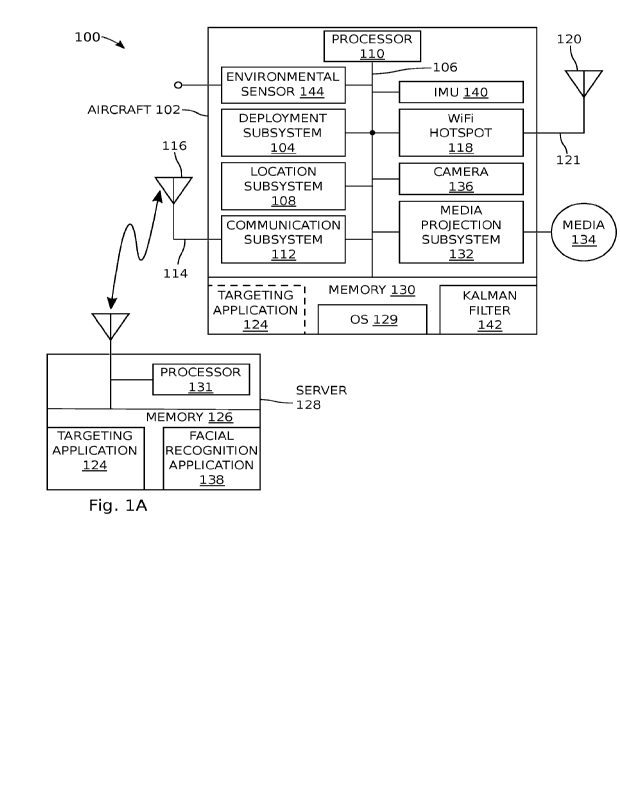
Figs. 1A and 1B are schematic block diagrams of an aircraft
media system. The system 100 comprises an aircraft 102, which may be a
micro air(aerial) vehicle (MAV) or miniature unmanned aerial vehicle
(UAV), more colloquially known as a drone, or even an manned aircraft or
helicopter. The system 100 is not limited to any particular type of
aircraft. A deployment subsystem 104 has an interface on line 106 to
supply an enablement signal with an identification code, in response to an
aircraft 102 maintaining a selected midair position in the atmosphere
above the ground. A location subsystem 108 determines the midair
geographic location of the aircraft 102, which is provided on line 106.
Examples of a location subsystem 108 include a Global Positioning
Satellite (GPS) system receiver, assisted GPS taking advantage of cell
tower data, a Wireless Local Area Network IEEE 802.11 (WiFi)
positioning system, cell-site multilateration, inertial system, or a hybrid
positioning system. Hybrid positioning systems find location using
several different positioning technologies, such as GPS, combined with cell
8
CA 03192671 2023- 3- 14
WO 2022/060416
PCT/US2021/026525
tower signals, wireless internet signals, Bluetooth sensors, IP addresses,
and network environment data. Cell tower signals have the advantage of
being less hindered by buildings or bad weather, but they usually provide
less precise positioning. WiFi positioning systems may give very exact
positioning in urban areas with high WiFi density, depending on a
comprehensive database of WiFi access points. Further, a LORAN type
system or LoJackg type system might be adapted for the purpose of
location determination. In one aspect, the aircraft can be equipped with
an Inertial Measurement Unit (IMU), such as an accelerometer or
gyroscope, to detect changes in location, used to increase the accuracy of
other location methods.
A communications subsystem 112 has an interface to receive
verification information including the enablement signal, identification
code, and geographic location on line 106. The communication subsystem
112 has an interface on line 114, connected to antenna 116, to transmit
the verification information to a server. In some aspects, the
identification code can be extrapolated from an address associated with
the communications subsystem 112, the location subsystem 108, or the
aircraft 102. Otherwise, the identification code is a code loaded into
memory 130, or alternatively it can be a mechanical device, such as a DIP
switch. The most typical examples of a communication subsystem are
cellular systems (e.g., Global System for Mobile Communications (GSM),
Universal Mobile Telecommunications System (UMTS)-time division
duplexing (TDD), Long-Term Evolution (LTE), 4th Generation, or 5th
Generation), and the like. Less typically, the communications subsystem
9
CA 03192671 2023- 3- 14
WO 2022/060416
PCT/US2021/026525
may be enabled with WLAN IEEE 802.11 (WiFi.), or even Long Range
Wireless transceiver. Some examples of a Long Range Wireless system
include Digital Enhanced Cordless Telecommunications (DE CT),
Evolution-data Optimized (EVDO), General Packet Radio Service (GPRS),
High Speed Packet Access (HSPA), IEEE 802.20 (iBurst), Multichannel
Multipoint Distribution Service (MMDS), Muni WiFi, commercial
satellite, and IEEE 802.16 Worldwide Interoperability for Microwave
Access (WiMAX (WiBro)). As another alternative, the communication
messages may be stored in the aircraft memory 130 and periodically
downloaded using a wireless or hardwire connection. The system 100 is
not limited to any particular type of communication subsystem.
Regardless of the type of communications subsystem used,
the aircraft 102 may further comprise a publically accessible WLAN IEEE
802.11 access point (AP) 118, commonly known as a WiFi hotspot. WiFi is
the most likely choice since most user smartphone or personal
communication devices are typically WiFi equipped. Alternatively, but
less common, the access point 118 may be a Wireless Personal Area
Network (WPAN) IEEE 802.15, examples of which include Li-Fi, wireless
USB, and Bluetooth. Even more unlikely as an access point are Long
Range Wireless systems. In the case of the WiFi hotspot being the
communications subsystem, items 112 and 118 would be collocated.
otherwise, the WiFi hotspot 118 is connected to the communications
subsystem 112 through line 106 and is also connected to antenna 120 on
line 122.
CA 03192671 2023- 3- 14
WO 2022/060416
PCT/US2021/026525
The system 100 may further comprise a targeting software
application 124 stored in a non-transitory memory, enabling a sequence of
processor executable instructions permitting the selection the midair
position from a plurality of potential midair positions. The non-transitory
memories described herein may be any type or form of non-volatile
storage device or medium capable of storing data and/or other
computer-readable instructions. Examples of memories include,
without limitation, Read Only Memory (ROM), flash memory, or any
other suitable memory device. Although not required, in certain
embodiments, the systems described herein may include both a
volatile memory unit and a non-volatile storage device. The memory
may be implemented as shared memory and/or distributed memory in
a network device. As shown, the targeting application 124 is embedded
in the memory 126 of server 128, or in a network of servers (not shown).
Alternatively, as shown in phantom, the targeting application 124 may be
embedded in the memory 130 of the aircraft.
In one aspect, each potential midair position has a
corresponding weighted value. In another aspect, the identification code
or aircraft is associated with a first entity, and the first entity receives a
reward corresponding to the value of the selected midair position. The
midair position may be either a stationary position or a moving flight
path. The term "stationary" as used herein is relative, as the ability of an
aircraft to hover without moving is dependent upon the type of aircraft
and weather conditions. In the case of fixed wing aircraft, hovering in a
11
CA 03192671 2023- 3- 14
WO 2022/060416
PCT/US2021/026525
stationary position may entail flying in a pattern (e.g., circular or figure-
8)
around a fixed location.
As used herein, an "entity" may be a person, a business, a
corporation, or any type of social or business unit able to claim ownership
of, or association with, the identification code, aircraft 102, system 100,
server 128, or server clients (discussed below).
The most obvious type of reward is money. However, the
first entity may alternatively be rewarded with bitcoin, cryptocurrency,
coupons, or services. In one aspect, the target location is selected from a
plurality of weighted (in value of importance) target locations, in response
to the specific geographic location of where the media projection
subsystem or WiFi hotspot is enabled. For example, the target location
may be weighted in response to geographic location factors such as
proximate vehicular traffic, line of sight from a particular vantage point,
proximate pedestrian traffic, proximity to cultural events, proximity to
cultural facilities, and combinations thereof. A cultural event is generally
understood to be an activity involving human beings. Likewise, a cultural
facility is a facility used by human beings, such as a museum, office
building, or grocery store parking lot. As a more explicit example, a target
location may have a first value if the media projection subsystem 132 is
enabled within X feet of a particular location, and second value, greater
than the first value, if the media projection subsystem is enabled within
X/2 feet of the same location. Other factors reflected in the weighting of
the target locations may include the type of media being projected, the
time of day, the day of the week, the date, the length of time the media is
12
CA 03192671 2023- 3- 14
WO 2022/060416
PCT/US2021/026525
being projected, and combinations thereof. There may be locations, such
as parks, hospitals, or freeways where signage is legally restricted, and in
one aspect these locations are given a target value of zero. In one aspect,
the system may even prevent the enablement of the media projection
subsystem in legally restricted areas. The system 100 described herein is
not limited to any particular factors weighting a target location. The
system may be interactive in the sense that the first entity may select a
deployment location after determining the value of a location. In this
sense, the targeting application does not so much direct the media
presentation subsystem to a particular predetermined location, as suggest
multiple possible locations. Although the target locations and weights
may be predetermined, in some aspects the weighting for non-
predetermined areas may be calculated concurrently with the deployment
of the media projection subsystem. That is, the target locations and the
target location weights need not necessarily be predetermined.
As is common in many computer systems, a processor 110 is
connected to the bus line 106, to pull operating instructions from
operating system (OS) 129 in memory 130, and manage communications
between the various components of system 100. Likewise, server 128
would be enabled through the use of processor 131. For ease of
understanding, the above-described functions have been described as
individual components. However, it should be understood that in practice,
multiple functions may be performed by a single device or subsystem.
Fig. 2 is a plan view of a geographic regions cross-referenced
to the weighted value of various midair positions. As shown, the regions
13
CA 03192671 2023- 3- 14
WO 2022/060416
PCT/US2021/026525
along Main Street have a value of 1, the highest rated value. The regions
along Broadway have a value of 2. The regions along Oak have a value of
3. The region along Elm near Main Street have a value of 3, which
decreases to a value of 4 near Sinclair Street, and the regions along
Sinclair Street have a value of 5.
Returning to Fig. 1, the system 100 may optionally further
comprises a media projection subsystem 132 attached to the aircraft 102,
having an interface 134 to project media, as well as an interface on line
106. In one aspect, the media projection subsystem 132 is selectively
enabled. Some examples of the media interface 134 include an electrically
passive screen (flexible or rigid), a lighted screen, a field of light
emitting
diodes (LEDs), or a holographic display. In other words, the media
interface may be a 2-dimensional or 3-dimensional image, which may or
may not change. The media interface 134 may also broadcast sounds as
an alternative, or in addition, to the displayed image. In the case of a
stationary position, the aircraft may rotate the media projection
subsystem around a vertical z axis in a selected midair stationary
position. In one variation, the deployment system 104 may supply the
enablement signal in response to the media projection subsystem 132
being enabled, with the first entity receiving no reward if the media
projection subsystem is not being enabled.
In one aspect, the communications subsystem 112 receives
media uploads from the server 128, and the communications subsystem
provides the media uploads to the media projection subsystem 132 for
presentation. In another aspect, the aircraft 102 further comprises a
14
CA 03192671 2023- 3- 14
WO 2022/060416
PCT/US2021/026525
camera 136 having an output on line 106 to supply images of a proximate
geographic location to the aircraft 102. The communications subsystem
112 transmits these images to the server 128 or the images are stored
them in local memory 130. In one variation, a facial recognition software
application 138, a form of Biometric Artificial Intelligence, is stored in the
non-transitory memory 126 of the server 128, enabling a sequence of
processor executable instructions for comparing the received camera
images to facial data The facial recognition application cross-references
recognized facial data to associated publically available social network
data. DeepFace is an example of one such facial recognition system.
Optionally, the facial recognition software application 138 may include
components that select media in response to the social network data and
transmit the media to the aircraft communications subsystem 112. The
communications subsystem 112 receives the media uploads from the
server 128, and provides the media uploads to the media projection
subsystem 132 for presentation. For example, the media may be images
associated with a user's Facebook entries or contacts.
The camera images may also be used to modify the value of
the target location. For example, the recorded traffic in a location may be
greater than anticipated, and the target value adjusted accordingly. That
is, images recording higher pedestrian or vehicular traffic may have
greater value. The data may be used to help determine the efficacy of the
media or location. Alternatively or in addition, the camera images may
act to verify that the media projection subsystem 132 has been enabled.
In one aspect, simply recording a change in images, and thus proximate
CA 03192671 2023- 3- 14
WO 2022/060416
PCT/US2021/026525
traffic, can be used as a means for proving media projection subsystem
en ablement.
In one aspect, as described in more detail in the explanation
of Figs. 5A through 5J, the system 100 further comprises an aircraft pod
including a plurality of aircraft, with each aircraft supplying an
enablement signal in response to maintaining a unique midair position.
As such, the pod of aircraft forms a position matrix with each aircraft
midair position assigned with respect to adjacent aircraft midair positions.
The end result is that the combined pod of aircraft visual displays form a
summed display matrix image billboard. In one aspect, the aircraft 102
may include an Inertia Measurements Unit (IMU) 140. The IMU 140 may
take the form of accelerometers aligned in 3 orthogonal axes, gyroscopes,
magnetometers, or a combination of these devices. Inertial Measurement
Units, also called inertial motion units, are devices that facilitate
continuous computation of the orientation of the objects to which they are
attached. IMUs typically have multiple single- or multi-axis sensors, such
as gyroscopes, accelerometers, and magnetometers. Ideally, the
accelerometer and magnetometer respectively measure the field strength
of the local gravitational and magnetic fields produced by a reference
object, such as Earth, and in turn produce sensor field strength readings.
The gyroscope measures the rotational speed of the sensor relative to
itself, producing a sensor rotational speed reading. The sensor field
strength and rotational speed readings may be used singularly or in
combination to compute the orientation of the IMU and its associated
objects relative to the reference object (aircraft). Further, the aircraft 102
16
CA 03192671 2023- 3- 14
WO 2022/060416
PCT/US2021/026525
may include a Kalman filter 142 embedded in the memory 130, enabling a
sequence of processor instructions for estimating variables, such as wind
and other weather-related occurrences whose effects impact precisely
locating the aircraft.
In another aspect, the aircraft 102 may further comprise an
environmental sensor 144, such as might be used to measure wind,
pressure, and temperature variables. Again, the environment data
collected can be used, with or without the IMU data and the Kalman
filter, to aid in more precisely locating the aircraft.
Fig. 3 is a schematic block diagram of the server. For
convenience, all the components associated with server 128 are shown
embedded as a single block, but it should be understood that these
components are not necessarily embedded in a single hardware unit, and
are not necessarily in communication with each other. As shown, the
server 128 comprises a first interface on line 300, connected to antenna
302 through communications device 310, to receive the verification
information from the aircraft communication subsystem 112. A second
interface on line 304, also referred to as a customer portal, receives first
client goals such target market, deployment hours, deployment rate, and
midair positions to name a few examples. Otherwise, a client satisfaction
software application 306, embedded in memory 126, includes processor
instructions for determining the above-mentioned client goals. For
example, the client satisfaction software application 306 may determine
midair positions meeting the first client goals in response to factors such
as location, local demographics, traffic, population density, length of
17
CA 03192671 2023- 3- 14
WO 2022/060416
PCT/US2021/026525
deployment, and combinations thereof. An operating system 308 works in
cooperation with the processor 131 to enable software applications in
memory 126 and to process information to and from communications
device 310.
In one example aircraft 102 comprises a selectively enabled
media projection subsystem 132 and the server 128 is associated with a
second entity (see Fig. 1). Then, a server client provides a reward to the
second entity when the media projection subsystem 132 is enabled, but
provides no reward to the second entity when the media projection
subsystem is not enabled. Similarly, rewards to the first or second
entities may be based upon the volume of traffic through the WiFi hotspot
118.
In one aspect, the server 128 further includes a Kalman filter
310 to aid in precisely locating the aircraft. The Kalman filter 310, if
necessary, may be embedded with the server 128, as opposed to aircraft,
in an effort to minimize aircraft processor functions. However, this
variation would require that the Kalman filter 310 receive IMU data
and/or environmental data, such a wind speed and direction, from the
aircraft itself or from proximate ground stations.
Fig. 4 is a schematic block diagram of an aerial
communication system providing publically accessible Internet service.
As in Fig. 1, the system 400 is associated with aircraft 102, which in turn,
comprises a location subsystem 108 to determine the midair geographic
location of the aircraft. A communications subsystem 112 has an interface
on line 106 to receive verification information including the geographic
18
CA 03192671 2023- 3- 14
WO 2022/060416
PCT/US2021/026525
location, and an interface to transmit the verification information to a
server 128 via antenna 116. A WLAN IEEE 802.11 (WiFi) hotspot 118
accepts Uniform Resource Locator (URL) address requests from a user
device 400 (e.g., a smartphone) via antenna 120, and transmits the URL
address requests, via the communications subsystem 112, to a Domain
Name System (DNS) service 402 embedded with the server 128. The DNS
service 402 makes Internet Protocol (IP) address searches, if necessary,
via the Internet interface on line 404. A listing of IP addresses can be
stored in memory, which may be of value to server clients. In some
aspects the IP addresses can be cross-referenced to user device
identification information.
Optionally, the aircraft 102 may comprise a media projection
subsystem 132, as explained above. In this case, the server 128 may
further comprise a media searcher application 406, stored in a non
-
transitory memory 126, and enabled as a sequence of processor
instructions for accessing media associated with URL addresses, and
transmitting the accessed media to the aircraft communication subsystem
112. The communications subsystem 112 receives the accessed media
from the server 128 supplies the accessed media to the media projection
subsystem 132 for presentation. In one aspect, the media projection
subsystem 132 is selectively enabled. The media projection subsystem
enablement may be triggered locally before the aircraft is deployed, or
remotely after the aircraft arrives at the desired midair position, for
example, via instructions sent from the server 128, or using an
independent remote control device.
19
CA 03192671 2023- 3- 14
WO 2022/060416
PCT/US2021/026525
Alternatively, if there is no media projection subsystem 132,
or if the media projection subsystem is not enabled, the communications
subsystem 112 may receive the above-described accessed media from the
server 128, and provide the accessed media to the WiFi hotspot 118, which
in turn provides the accessed media to the user device 400.
In one variation, the WiFi hotspot receives a URL address
request from user device 400 and the aircraft 102 changes midair position
so as remain in WiFi communication with the user device. The aircraft
may continually keep pace with the user device or return to its original
midair position after moving a predetermined distance from its original
position, or after losing contact with the user device. Alternatively, the
aircraft may select a new midair position after moving a predetermined
distance from the its original position, or after losing contact with the user
device. In another variation, as described in the explanation of Fig. 1, the
system further comprises a targeting software application (124, see Fig. 1)
that permits the selection of the midair position from a plurality of
potential midair positions. Each potential midair position may have a
corresponding weighted value, and an entity associated with the aircraft
or system may receive a reward corresponding to the value of the selected
midair position. The midair position may be a stationary position or a
flight path.
Figs. 5A through 5J depict aspects of an aerial billboard
system. The system 500 comprises a pod of aircraft 502 comprising a
plurality of aircraft 102. Returning briefly the Fig. 1, and as explained in
greater detail above, each aircraft 102 in this system 500 comprises a
CA 03192671 2023- 3- 14
WO 2022/060416
PCT/US2021/026525
media projection subsystem 132, and a location subsystem 108 that
determines the midair geographic location of the aircraft. In one aspect,
the aircraft positions and the media projection subsystem deployment are
assumed to occur correctly, or perhaps verification is performed using
camera images from an aircraft or from the ground. Otherwise, a
deployment subsystem 104 has an interface to supply an enablement
signal with an identification code, in response to an aircraft maintaining a
unique midair position and the media projection subsystem being enabled.
A communications subsystem 112 has an interface to receive verification
information including the enablement signal, identification code, and
geographic location, and an interface to transmit the verification
information. In one aspect, the communications subsystem (e.g., cellular)
transmits verification information to a server 128. Alternatively, data can
be collected by a central controller aircraft using either a WLAN, cellular,
or proprietary link, or data can be stored in local memory. Data can be
collected in the central controller memory for subsequent downloading,
and relayed to a land-based server. In another aspect, the verification
information is sent to a simple handheld controller of smartphone
application. Returning to Fig 5A, the plurality of aircraft forms a position
matrix with each aircraft midair position assigned with respect to
adjacent aircraft midair positions. Alternatively stated, each aircraft
position is unique and is assigned with respect to a fixed position in space.
The combined plurality of aircraft visual displays form a summed display
matrix image billboard (i.e., a billboard image). In this simple example,
each individual aircraft projects an image represented by the asterisk
21
CA 03192671 2023- 3- 14
WO 2022/060416
PCT/US2021/026525
symbol, and the overall summed display matrix image billboard depicts a
smiling face. Although the figure implies that each media projection
subsystem projection (asterisk) is identical, it should be understood that
some or all of the aircraft may present unique image displays. The figure
also implies that each image is a simple on/off pixel. However, as
presented below, each image may be complex. Further, the image of Fig.
5A implies a 2-dimensional position matrix, for example, with aircraft
aligned in the x and z planes. However, it should be understood that the
position matrix may be 3 dimensional with aircraft aligned in the x, y, and
z planes to make more complex billboard images. In addition to each
aircraft projecting a consistent, non-changing image, it should also be
understood that some or all of the aircraft media projection subsystems
may project a changing medium, so as to present a movie or video like
image. One simple example would be some or all the projected images
changing color. Further, some or all of the aircraft communications
subsystem may supply uploaded media to the media projection subsystem,
so that the projected media can be updated on-the-fly.
As shown in Fig. 5A, each aircraft 102 may maintain a
midair stationary position. Fig. 5B depicts an image where the meclia
projection subsystems operate as "pixels" to form a billboard. In other
words, the billboard is formed by simply enabling displays, for example,
each aircraft simply projecting a white color, and arranging the pixels so
as the form a message.
As shown in Fig. 5C, the midair position of the aircraft may
stay the same (position 1), but some of the aircraft positions vary with
22
CA 03192671 2023- 3- 14
WO 2022/060416
PCT/US2021/026525
respect to adjacent aircraft midair positions from Time 1 to Time 2.
Further, some of the display images change (e.g., from portions of a lip to
teeth).
Fig. 5D depicts an example of aircraft midair positions as a
component of a group flight path, moving from position 1 to position 2.
Alternatively but not shown, the aircraft midair positions may be a
component of a group flight path where adjacent aircraft maintain
constant midair positions with respect to adjacent aircraft Fig. SE
depicts two related position matrices where the aircraft maintain constant
midair positions with respect to each other, but the media display changes
from Time 1 to Time 2.
Fig. 5F depicts an exemplary drone aircraft with an LED
array display screen enabling the media projection subsystem. The LED
is directional, facing one particular side of the drone. However, omni-
directional, circular surrounding, and persistent image fan displays are
also known. Fig. 5G shows that the LED array can be tilted for viewing
angle.
The billboard system can also be used in a manner similar to
a JumboTron, such as might be seen at an outdoor sports stadium or
public place. Figs. 5H through 5J depict the media projection subsystems
of several aircraft presenting complex images. For example, in Fig. 511
the letter "A" is distributed across several adjacent media projection
subsystems. If the images are electronic lighted images, the images
presented by the media projection subsystems may change, causing the
overall billboard image to change, as shown in the transition from Fig. 511
23
CA 03192671 2023- 3- 14
WO 2022/060416
PCT/US2021/026525
to Fig. 51. Further, the images of the media projection subsystems, as
well as the position matrix alignment of the aircraft may change, as
shown in the transition from Fig. 51 to Fig. 5J. Although not explicitly
shown, the location of the position matrix may also change with respect to
the underlying earth, as shown in the pod transition in Fig. 5D.
As described in greater detail in the explanation of Fig. 1, the
system 500 may include a targeting software application, embedded in a
non-transitory memory of the server or aircraft, enabling a sequence of
processor executable instructions permitting the selection of the location
of the position matrix from a plurality of potential position matrix
locations. Each potential position matrix location may have a
corresponding weighted value, and an entity associated with the aircraft,
identification code, or server may receive a reward corresponding to the
value of the selected position matrix location. The targeting application
may be embedded with a controller aircraft, which relays instructions to
the other aircraft. Otherwise, the targeting application may be embedded
with a server and instructions are relayed through a controller aircraft, or
sent directly to each individual aircraft. Finally, each individual aircraft
may include its own independent targeting application.
Returning to Fig. 5A, system 500 may further comprise a pod
automotive support vehicle 504 for transporting the pod of aircraft 502 to
a destination proximately located near the position matrix. The support
vehicle 504 may comprise a charging subsystem 506 with charging
stations for the aircraft 102. The support vehicle 504 may include a
location subsystem 508 to determine the destination location. Examples
24
CA 03192671 2023- 3- 14
WO 2022/060416
PCT/US2021/026525
of locations subsystems have been provided above. The support vehicle
may also include a communications subsystem 510 having an interface to
antenna 512 to transmit the destination location to the pod of aircraft 502.
Examples of communication subsystems have been provided above. The
communications subsystem 510 may be used to upload aircraft
verification information, the destination location, aircraft health status
(e.g., charge), or recorded images to a server, for example. In another
aspect, the support vehicle 504 further comprises a recording subsystem
514 including a camera 516 to record the summed display matrix image
billboard or the position of individual aircraft 102, such as might be of
value for calibration purposes. The images can, alternatively, be stored in
local memory or downloaded to a server. In another aspect, the support
vehicle may further comprise a server 518 with an associated non-
transitory memory (not shown). In one aspect, one or more of the aircraft
may include a camera to record the billboard image and/or record crowd
reaction to the billboard.
In one aspect, the system 500 may incorporate the use of
ranger aircraft 520 or ground stations 522 whose purpose is to track
changing weather conclitions, such as wind speed, wind direction,
temperature, and air pressure. The ranger aircraft 520 or ground station
522 supply an environmental report of these conditions so that the
aircraft in the pod 502 have advance warning of variables that may affect
the ability of the aircraft 102 to maintain precise locations. The ground
station 522 may be incorporated with the pod support vehicle. The ranger
aircraft 520 may be removed from the rest of the aircraft in the pod, as
CA 03192671 2023- 3- 14
WO 2022/060416
PCT/US2021/026525
shown, perhaps positioned to the prevailing wind to provide advanced
warning of wind changes. Alternatively, the ranger aircraft may be
embedded with the rest of the pod, and may be equipped with a media
projection subsystem. In one aspect, each aircraft may incorporate an
environmental sensor. The environmental report may be sent to the pod
support vehicle and then relayed individually to the aircraft, or relayed to
a control aircraft for subsequent distribution. Depending on the control
system used, the aircraft make position adjustments individually, or
follow position adjustment instructions from the control aircraft or the pod
support vehicle.
As noted above in the explanation of Fig. 1, the aircraft may
be equipped with IMUs. As an alternative, or in addition to receiving
environmental reports, the aircraft may make position adjustments in
response to IMU measurements. Again, the position adjustments may be
made on an individual aircraft basis, coordinated by a controller aircraft,
or even by a ground based server. A Kalman filter embedded with the
individual aircraft, controller aircraft, or even a ground based server may
aid in processing the IMU data.
The systems described above can be adapted for use in a
model where an advertiser pays for service based upon performance. For
example, an advertising client may contract with a system provider
stipulating a target market and deployment hours/rate. The system
provider determines geo-fenced locations that meet or exceed the
advertiser's target market based on location, demographics, traffic,
population density, and other variables. Platform deployment time,
26
CA 03192671 2023- 3- 14
WO 2022/060416
PCT/US2021/026525
location, quality code, and user information are recorded by the server. A
system provider algorithm determines platform performance based on
length of deployment, contracted rate, maintenance cost reimbursement,
and location quality code.
The systems described above support a targeted mobile sign
system, where the mobile sign is selectively deployed. As explained above,
a publically accessible WLAN access point is also provided. In cooperation
with the deployment of the sign, an organization or user associated with
the sign is directed to preferred locations. For example, the deployment of
the sign along a busy urban thoroughfare is likely to have a greater value
than deployment on a suburban side-street. Other factors that may be
used to calculate target value may include the time of day and the length
of deployment. Thus, some key features to the system are determining
that the sign and/or WiFi has actually been deployed, and once deployed,
the location of the system. In some aspects, the sign is a type of visual
display, but other aspects may include just an auditory presentation, a
combination visual and auditory presentation, or a presentation that is
able to interact with a proximate viewer.
In one aspect, the system communicates a deployment
message and supporting systems receive the deployment message and
determine the deployment location. This information can be relayed in
real-time to a server entity. Alternatively, the information can stored in
memory of the supporting system and transferred to the server at periodic
intervals or upon the attainment of predetermined metrics such as the
number of deployments.
27
CA 03192671 2023- 3- 14
WO 2022/060416
PCT/US2021/026525
Fig. 6 is a flowchart illustrating a method for aircraft media
projection. Although the method is depicted as a sequence of numbered
steps for clarity, the numbering does not necessarily dictate the order of
the steps. It should be understood that some of these steps may be
skipped, performed in parallel, or performed without the requirement of
maintaining a strict order of sequence. The method steps are supported
by the above system descriptions and, generally, the method follows the
numeric order of the depicted steps. The method starts at Step 600.
Step 602 supplies an enablement signal with an
identification code, in response to an aircraft maintaining a selected
midair position in the atmosphere above the ground. The selected midair
position may be a stationary position or a flight path (moving position).
Step 604 verifies the midair geographic location of the aircraft. In some
aspects, Steps 602 and 604 are performed simultaneously. Step 606
communicates verification information including the enablement signal,
identification code, and geographic location, to a server. Alternatively, the
verification information is stored in an aircraft local memory. In one
aspect, Step 601a provides a publically accessible WLAN IEEE
802.11(WiFi) hotspot attached to the aircraft. In Step 605a the WiFi
hotspot accepts URL address requests from a user device proximately
located to the geographic location. Then, communicating verification
information in Step 606 includes communicating the URL address
requests to a DNS service, which may be embedded with the server.
In another aspect, Step 601b selects the midair position from
a plurality of potential midair positions having corresponding weighted
28
CA 03192671 2023- 3- 14
WO 2022/060416
PCT/US2021/026525
values. Step 608 provides a reward to an entity associated with the
aircraft responsive to the value of the selected midair position.
Alternatively, the rewards may be based upon WLAN traffic density.
In one variation, Step 605b projects media from a media
projection subsystem attached to the aircraft, which may be a displayed
image, broadcast sound, or both. For example, the media may be
projected by rotating the media projection subsystem around a vertical z
axis in a selected midair stationary position. If the media projection
subsystem is selectively enabled, that is, if the media is selectively
projected, Step 610 supplies a reward to an entity associated with the
aircraft when the media projection subsystem is enabled. In one aspect,
in Step 612 the media projection subsystem receives media uploads from
the server for projection.
In another variation, Step 605c photographs images of a
geographic location proximate to the aircraft. Then, communicating
verification information in Step 606 includes communicating the images
to the server. Optionally, in Step 614 a facial recognition software
application, stored in a non-transitory memory of the server, enables a
sequence of processor executable instructions for comparing the received
camera images to facial data, and cross-referencing recognized facial data
to associated publically available social network data. As another option,
in Step 616 the facial recognition application selects media in response to
the social network data. The media may include commercial goods or
services known to be associated with a URL address or an entity's
publically stated preferences and buying habits. In Step 618 the server
29
CA 03192671 2023- 3- 14
WO 2022/060416
PCT/US2021/026525
transmits the media to the media projection subsystem, and in Step 620
the media projection subsystem attached to the aircraft projects the media
uploads. In a manner similar to a Wireless Sensor Network (WSN), which
collects environmental data from a group of dispersed sensors, the system
described herein can be adapted to collect social data or for marketing.
Fig. 7 is a flowchart illustrating an aerial communication
method. The method starts at Step 700. In Step 702 a location subsystem
attached to an aircraft determines the midair geographic location of the
aircraft, which may be a stationary position or a moving flight path. In
Step 704 a communications subsystem attached to the aircraft transmits
verification information including the geographic location to a server. In
Step 706 a WLAN IEEE 802.11 (WiFi) hotspot attached to the aircraft
accepts URL address requests from a user device, and transmits the URL
address requests, via the communications subsystem, to a DNS service.
In one aspect, in Step 703 a media projection subsystem
attached to the aircraft projects media. In Step 708 a media searcher
application, stored in a non-transitory memory of the server and enabled
as a sequence of processor instructions, accesses media associated with
URL addresses. Step 710 transmits the accessed media to the media
projection subsystem. Alternatively, Step 711 transmits the accessed
media to the WiFi hotspot for uploading to a connected user device (e.g., a
smartphone). In another aspect, in Step 706 the WiFi hotspot receives a
URL address request from a first user device, and in Step 712 the aircraft
changes midair position so as remain in WiFi communication with the
first user device.
CA 03192671 2023- 3- 14
WO 2022/060416
PCT/US2021/026525
In one variation, in Step 701 a targeting software
application, stored in a non-transitory memory, enables a sequence of
processor executable instructions permitting the selection of the midair
position from a plurality of potential midair positions, which may have
corresponding weighted values. Optionally, an entity associated with the
aircraft, the server, or the WiFi hotspot receives a reward in Step 714
corresponding to the value of the selected midair position.
Fig. 8 is a flowchart illustrating an aerial billboard method.
The method begins with Step 800. In Step 802 a visual display is
projected from each aircraft in a pod made up of a plurality of aircraft. In
addition to each aircraft projecting a consistent, non-changing display
image, it should also be understood that some or all of the aircraft may
project a changing medium (display image), so as to present a movie or
video like image. Further, some or all of the aircraft may receive
uploaded media, so that the projected media can be updated on-the-fly.
In Step 804 each aircraft supplies an enablement signal with
an identification code, in response to maintaining a unique midair
position. In Step 806 a location subsystem attached to each aircraft
determines the midair geographic location of the aircraft. In Step 808 a
communications subsystem attached to each aircraft transmits
verification information including the enablement signal, identification
code, and geographic location. The verification information can be
collected by a server, handheld controller, or smartphone application.
Optionally, Step 808 can be bypassed. No verification information is sent
based upon the assumption that the aircraft are projecting media in Step
31
CA 03192671 2023- 3- 14
WO 2022/060416
PCT/US2021/026525
802 and the aircraft are correctly positioned in Step 806. In one aspect,
verification is performed using camera images taken by one of the aircraft
or by a ground source. In one aspect, one of the aircraft from the plurality
of aircraft takes on the role of collecting data from the other aircraft.
Optionally, this controller aircraft may be communication with a server or
support vehicle, acting as a relay for data collection and instructions.
Alternatively, each aircraft may act independently of a central controller
aircraft or a (land-based) server. In Step 810 the plurality of aircraft
forms a position matrix with each aircraft midair position assigned with
respect to adjacent aircraft midair positions. In Step 812 the combined
plurality of aircraft visual displays form a summed display matrix image
billboard. In one aspect, Step 806 uses IMUs to make inertial
measurements to aid in determining the precise midair positions of the
aircraft. The IMU measurements can be made by a central controller
aircraft who distributes coordinated position adjustment instructions to
the pod, or each aircraft can be equipped with an IMU to made
independent position adjustments. In another aspect, a ranger aircraft in
Step 805a makes measurements in the environment near the position
matrix that are communicated to the pod in Step 805b, to aid in
determining the aircraft midair positions in Step 806. Step 805b may
communicate the environmental data individually to aircraft in the pod.
Alternatively, to coordinate movement, the environmental data is sent to
a central controller aircraft or ground based server, who then supply
instructions to the pod. As another alternative, each aircraft makes
32
CA 03192671 2023- 3- 14
WO 2022/060416
PCT/US2021/026525
independent environmental measurements that are used in determining
their midair positions in Step 806.
In one aspect, each aircraft in Step 804 maintains one of the
following midair positions: stationary, varying with respect to adjacent
aircraft midair positions, as a component in a group flight path where
aircraft maintain constant midair positions with respect to adjacent
aircraft, or as a component in a group flight path with midair positions
that vary with respect to adjacent aircraft
In another aspect, in Step 801a a targeting software
application, stored in a non-transitory memory, enables a sequence of
processor executable instructions permitting the selection of the location
of the position matrix from a plurality of potential position matrix
locations, which may have corresponding weighted values. In one aspect,
one aircraft provides location instructions to the other aircraft in the
group. Optionally, in Step 814 a first entity associated with the
identification codes or aircraft receives a reward corresponding to the
value of the selected position matrix location.
In one aspect, in Step 801b an automotive support vehicle
delivers the pod of aircraft to a destination near the position matrix. In
Step 816 the pod of aircraft location return to the support vehicle for
charging and/or media uploads. In another aspect, in Step 813 the
support vehicle uses a camera to record the summed display matrix image
billboard or the positions of individual aircraft.
System and methods have been provided for monitoring the
deployment of media and the occupation of midair geographic locations.
33
CA 03192671 2023- 3- 14
WO 2022/060416
PCT/US2021/026525
Examples of particular message structures, schematic block linkages, and
hardware units have been presented to illustrate the invention. However,
the invention is not limited to merely these examples. Other variations
and embodiments of the invention will occur to those skilled in the art.
WE CLAIM:
34
CA 03192671 2023- 3- 14
WO 2022/060416
PCT/US2021/026525
AERIAL BILLBOARD
RELATED APPLICATIONS
Any and all applications, if any, for which a foreign or
domestic priority claim is identified in the Application Data Sheet of the
present application are hereby incorporated by reference under 37 CFR
1.57.
BACKGROUND OF THE INVENTION
1. Field of the Invention
This invention generally relates to airborne position
monitoring networks and aerial billboards, more particularly, to a system
and method for location-targeting the delivery of media from an aircraft.
2. Description of the Related Art
A large segment of the population is connected to the
Internet for a considerable portion of the day. Many people, whether for
business or social reasons, believe that they must be connected 100% of
the time. Perhaps the most common mechanism people use for connecting
to the Internet is through a smartphone or properly enabled cell phone.
To reduce cell usage, and thus save money, Wireless Local Area Networks
(WLANs), such as IEEE 802.11 (WiFi), or Wireless Personal Area
Networks (WPANs), such as Bluetooth, are often used to connect a
smartphone to the Internet. WLAN and WPAN networks have a limited
range. Thus, connections to the Internet through a LAN are relatively
easy when the user is located near a known access point, such as at home
or at work. When away from known access points, LAN connections
CA 03192671 2023- 3- 14
WO 2022/060416
PCT/US2021/026525
become more difficult. This problem is alleviated through the use of
publically available access points, such as might be found in a coffee shop
or restaurant. However, publically accessible access points do not provide
blanket coverage in all geographic regions. Further, not all access points
are publically accessible.
Application Serial No. US 16/601,362, entitled SYSTEM
AND METHOD FOR TARGETING THE DISTRIBUTION OF MEDIA
FROM A MOBILE PLATFORM, invented by Peter Ta et al., and filed on
October 14, 2019, describes an automotive targeted parking system that
may include a WiFi access point (hotspot). However, automobiles are not
able to park in all locations in which a WiFi hotspot may be of use.
Drone aircraft are capable of a broader range of coverage
than an automobile, and their flight paths can be controlled from remote
locations. Drones have been used to present 2-dimensional, 3-
dimensional, and persistent illusion images using light emitting diodes
(LEDs) and liquid crystal displays (LCDs). However, to date, there
appears to be effort to use a drone to act as a publically accessible WLAN
access point. Neither has there been an effort made to team groups of
drones together to create a combined image in the form of a billboard.
It would be advantageous if a drone aircraft could be enabled
to act as a publically accessible WLAN access point.
It would be advantageous if the WLAN drone could be
directed to targeted stationary locations.
It would also be advantageous if the WLAN enabled drone
could be equipped with a media projection subsystem to display
36
CA 03192671 2023- 3- 14
WO 2022/060416
PCT/US2021/026525
advertising and community service messages. It would also be
advantageous if the media presentation subsystem could be selectively
enabled. It would be advantageous if groups of drone media projection
subsystems could be combined together to create combined image or aerial
billboard.
It would be advantageous if a Domain Name System (DNS)
service associated with the drone could track the Uniform Resource
Locator (URL) addresses requested through publically accessible WLAN.
It would be advantageous if the time and location of WLAN
services could be tracked, recorded, and continuously verified.
SUMMARY OF THE INVENTION
A system and method are disclosed herein for aircraft
positioning, with emphasis on the ability to provide a Wireless Local Area
Network (WLAN) IEEE 802.11 (WiFi) access point, media projection
subsystem, or both. Thus, the system may act as a mobile advertising
platform that seeks to expand and capture market share within the
outdoor advertising market segment by directing the selective deployment
of media to preferred target locations. Once in a selected flight path, the
media message can be activated remotely by electrical signaling (such as
Bluetooth, cellular, or WiFi). The system may transmit the following
information: (i) a unique identifier for the device in use (for example,
radio-frequency identification), (ii) the time, date, duration, and location
(using global positioning satellite (GPS) or cellular triangulation systems),
(iii) an indication that the media projection subsystem has been deployed,
37
CA 03192671 2023- 3- 14
WO 2022/060416
PCT/US2021/026525
and (iv) an indication that the WLAN access point is in use. Further, if
the WLAN access point is in use, the system relays Uniform Resource
Locator (URL) address requests from proximate users, and returns the
request results. Graphic information system (GIS) mapping technology
may be used to compensate a person or business entity associated with
the aircraft system for operating in specified locations.
Accordingly, an aircraft media system is provided. The
aircraft includes a deployment subsystem having an interface to supply an
enablement signal with an identification code, in response to an aircraft
maintaining a selected midair position in the atmosphere above the
ground. The midair position may be a stationary position or a moving
flight path. A location subsystem determines the midair geographic
location of the aircraft, and a communications subsystem, typically a
cellular link, has an interface to receive verification information including
the enablement signal, identification code, and geographic location, and
an interface to transmit the verification information to a server or to a
local memory for subsequent downloading. In one aspect, the system may
include a WLAN (e.g., WiFi) access point or hotspot that is available for
use by the public at large.
A targeting software application, stored in a memory of
either a server or the aircraft, enables a sequence of processor executable
instructions permitting the selection of the midair position from a
plurality of potential midair positions. Each potential midair position
may have a corresponding weighted value. For example, if the
identification code (i.e., the aircraft) is associated with a first entity,
the
38
CA 03192671 2023- 3- 14
WO 2022/060416
PCT/US2021/026525
first entity may receive a reward corresponding to the value of the
selected midair position.
In another aspect, the system may include a meclia projection
subsystem, which may be selectively enabled, having an interface to
project media. The media may be a visual image, broadcast sound, or
both. The deployment system may supply the enablement signal in
response to the media projection subsystem being enabled, with the first
entity receiving no reward if the media projection subsystem is not
enabled. In one variation, the communications subsystem receives media
uploads from the server, and the communications subsystem provides the
media uploads to the media projection subsystem. In another variation,
the aircraft rotates the media projection subsystem around a vertical z
axis in a selected midair stationary position.
In one aspect, the aircraft includes a camera having an
output to supply images of a proximate geographic location, which are
relayed to the server through the communications subsystem. In one
variation, a facial recognition software application, stored in a non-
transitory memory of the server, enables a sequence of processor
executable instructions for comparing the received camera images to facial
data. The facial recognition application cross-references recognized facial
data to associated publically available social network data. In another
variation, media can be selected in response to the social network data
and transmitted to the aircraft communications subsystem so that it can
be provided to the media projection subsystem.
39
CA 03192671 2023- 3- 14
WO 2022/060416
PCT/US2021/026525
If equipped with a publically accessible WLAN hotspot
(access point), the hotspot accepts URL address requests from a user
device and transmits the URL address requests, via the communications
subsystem, to a DNS service. If also equipped with a media projection
subsystem, the server may include a media searcher application for
accessing media associated with URL addresses, and transmitting the
accessed media to the aircraft communication subsystem. The
communications subsystem receives the accessed media from the server
and provides them to the media projection subsystem. Alternatively, the
media may be communicated directly to the user device via the WLAN
link. As above, a targeting software application may permit the selection
of weighted value the midair position from a plurality of potential midair
positions. Alternatively, it the WLAN hotspot receives URL address
requests from a first user device, the aircraft may change midair location
so as remain in WiFi communication with the first user device.
An aerial billboard system is also presented that includes a
pod of aircraft. Each aircraft in the pod includes a media projection
subsystem having an interface to project a visual display. A deployment
subsystem has an interface to supply an enablement signal with an
identification code, in response to an aircraft maintaining a unique midair
position and the media projection subsystem being enabled. A location
subsystem determines the midair geographic location of each aircraft. A
communications subsystem has an interface to receive verification
information including the enablement signal, identification code, and
geographic location, and an interface to transmit the verification
CA 03192671 2023- 3- 14
WO 2022/060416
PCT/US2021/026525
information to a server. The plurality of aircraft forms a position matrix
with each aircraft midair position assigned with respect to adjacent
aircraft midair positions, so that the combined plurality of aircraft visual
displays form a summed display matrix image billboard. Each aircraft
maintains one of the following: a midair position that is stationary,
varying with respect to adjacent aircraft midair positions, as a component
of a group flight path where aircraft maintain constant midair positions
with respect to adjacent aircraft, or as a component of a group flight path
with midair positions that vary with respect to adjacent aircraft. A
targeting software application may be used to permit the selection of the
location of the position matrix from a plurality of potential weighted value
position matrix locations, where an entity associated with the aircraft
receives a reward corresponding to the value of the selected position
matrix location.
Additional details of the above-described systems and
associated methods of implementation are provided below.
BRIEF DESCRIPTION OF THE DRAWINGS
Figs. 1A and 1B are schematic block diagrams of an aircraft
media system.
Fig. 2 is a plan view of a geographic regions cross-referenced
to the weighted value of various midair positions.
Fig. 3 is a schematic block diagram of the server.
Fig. 4 is a schematic block diagram of an aerial
communication system providing publically accessible Internet service.
41
CA 03192671 2023- 3- 14
WO 2022/060416
PCT/US2021/026525
Figs. 5A through 5J depict aspects of an aerial display
system.
Fig. 6 is a flowchart illustrating a method for aircraft media
projection.
Fig. 7 is a flowchart illustrating an aerial communication
method.
Fig. 8 is a flowchart illustrating an aerial billboard method.
DETAILED DESCRIPTION
Figs. 1A and 1B are schematic block diagrams of an aircraft
media system. The system 100 comprises an aircraft 102, which may be a
micro air(aerial) vehicle (MAV) or miniature unmanned aerial vehicle
(UAV), more colloquially known as a drone, or even an manned aircraft or
helicopter. The system 100 is not limited to any particular type of
aircraft. A deployment subsystem 104 has an interface on line 106 to
supply an enablement signal with an identification code, in response to an
aircraft 102 maintaining a selected midair position in the atmosphere
above the ground. A location subsystem 108 determines the midair
geographic location of the aircraft 102, which is provided on line 106.
Examples of a location subsystem 108 include a Global Positioning
Satellite (GPS) system receiver, assisted GPS taking advantage of cell
tower data, a Wireless Local Area Network IEEE 802.11 (WiFi)
positioning system, cell-site multilateration, inertial system, or a hybrid
positioning system. Hybrid positioning systems find location using
several different positioning technologies, such as GPS, combined with cell
42
CA 03192671 2023- 3- 14
WO 2022/060416
PCT/US2021/026525
tower signals, wireless internet signals, Bluetooth sensors, IP addresses,
and network environment data. Cell tower signals have the advantage of
being less hindered by buildings or bad weather, but they usually provide
less precise positioning. WiFi positioning systems may give very exact
positioning in urban areas with high WiFi density, depending on a
comprehensive database of WiFi access points. Further, a LORAN type
system or LoJackg type system might be adapted for the purpose of
location determination. In one aspect, the aircraft can be equipped with
an Inertial Measurement Unit (IMU), such as an accelerometer or
gyroscope, to detect changes in location, used to increase the accuracy of
other location methods.
A communications subsystem 112 has an interface to receive
verification information including the enablement signal, identification
code, and geographic location on line 106. The communication subsystem
112 has an interface on line 114, connected to antenna 116, to transmit
the verification information to a server. In some aspects, the
identification code can be extrapolated from an address associated with
the communications subsystem 112, the location subsystem 108, or the
aircraft 102. Otherwise, the identification code is a code loaded into
memory 130, or alternatively it can be a mechanical device, such as a DIP
switch. The most typical examples of a communication subsystem are
cellular systems (e.g., Global System for Mobile Communications (GSM),
Universal Mobile Telecommunications System (UMTS)-time division
duplexing (TDD), Long-Term Evolution (LTE), 4th Generation, or 5th
Generation), and the like. Less typically, the communications subsystem
43
CA 03192671 2023- 3- 14
WO 2022/060416
PCT/US2021/026525
may be enabled with WLAN IEEE 802.11 (WiFi.), or even Long Range
Wireless transceiver. Some examples of a Long Range Wireless system
include Digital Enhanced Cordless Telecommunications (DE CT),
Evolution-data Optimized (EVDO), General Packet Radio Service (GPRS),
High Speed Packet Access (HSPA), IEEE 802.20 (iBurst), Multichannel
Multipoint Distribution Service (MMDS), Muni WiFi, commercial
satellite, and IEEE 802.16 Worldwide Interoperability for Microwave
Access (WiMAX (WiBro)). As another alternative, the communication
messages may be stored in the aircraft memory 130 and periodically
downloaded using a wireless or hardwire connection. The system 100 is
not limited to any particular type of communication subsystem.
Regardless of the type of communications subsystem used,
the aircraft 102 may further comprise a publically accessible WLAN IEEE
802.11 access point (AP) 118, commonly known as a WiFi hotspot. WiFi is
the most likely choice since most user smartphone or personal
communication devices are typically WiFi equipped. Alternatively, but
less common, the access point 118 may be a Wireless Personal Area
Network (WPAN) IEEE 802.15, examples of which include Li-Fi, wireless
USB, and Bluetooth. Even more unlikely as an access point are Long
Range Wireless systems. In the case of the WiFi hotspot being the
communications subsystem, items 112 and 118 would be collocated.
otherwise, the WiFi hotspot 118 is connected to the communications
subsystem 112 through line 106 and is also connected to antenna 120 on
line 122.
44
CA 03192671 2023- 3- 14
WO 2022/060416
PCT/US2021/026525
The system 100 may further comprise a targeting software
application 124 stored in a non-transitory memory, enabling a sequence of
processor executable instructions permitting the selection the midair
position from a plurality of potential midair positions. The non-transitory
memories described herein may be any type or form of non-volatile
storage device or medium capable of storing data and/or other
computer-readable instructions. Examples of memories include,
without limitation, Read Only Memory (ROM), flash memory, or any
other suitable memory device. Although not required, in certain
embodiments, the systems described herein may include both a
volatile memory unit and a non-volatile storage device. The memory
may be implemented as shared memory and/or distributed memory in
a network device. As shown, the targeting application 124 is embedded
in the memory 126 of server 128, or in a network of servers (not shown).
Alternatively, as shown in phantom, the targeting application 124 may be
embedded in the memory 130 of the aircraft.
In one aspect, each potential midair position has a
corresponding weighted value. In another aspect, the identification code
or aircraft is associated with a first entity, and the first entity receives a
reward corresponding to the value of the selected midair position. The
midair position may be either a stationary position or a moving flight
path. The term "stationary" as used herein is relative, as the ability of an
aircraft to hover without moving is dependent upon the type of aircraft
and weather conditions. In the case of fixed wing aircraft, hovering in a
CA 03192671 2023- 3- 14
WO 2022/060416
PCT/US2021/026525
stationary position may entail flying in a pattern (e.g., circular or figure-
8)
around a fixed location.
As used herein, an "entity" may be a person, a business, a
corporation, or any type of social or business unit able to claim ownership
of, or association with, the identification code, aircraft 102, system 100,
server 128, or server clients (discussed below).
The most obvious type of reward is money. However, the
first entity may alternatively be rewarded with bitcoin, cryptocurrency,
coupons, or services. In one aspect, the target location is selected from a
plurality of weighted (in value of importance) target locations, in response
to the specific geographic location of where the media projection
subsystem or WiFi hotspot is enabled. For example, the target location
may be weighted in response to geographic location factors such as
proximate vehicular traffic, line of sight from a particular vantage point,
proximate pedestrian traffic, proximity to cultural events, proximity to
cultural facilities, and combinations thereof. A cultural event is generally
understood to be an activity involving human beings. Likewise, a cultural
facility is a facility used by human beings, such as a museum, office
building, or grocery store parking lot. As a more explicit example, a target
location may have a first value if the media projection subsystem 132 is
enabled within X feet of a particular location, and second value, greater
than the first value, if the media projection subsystem is enabled within
X/2 feet of the same location. Other factors reflected in the weighting of
the target locations may include the type of media being projected, the
time of day, the day of the week, the date, the length of time the media is
46
CA 03192671 2023- 3- 14
WO 2022/060416
PCT/US2021/026525
being projected, and combinations thereof. There may be locations, such
as parks, hospitals, or freeways where signage is legally restricted, and in
one aspect these locations are given a target value of zero. In one aspect,
the system may even prevent the enablement of the media projection
subsystem in legally restricted areas. The system 100 described herein is
not limited to any particular factors weighting a target location. The
system may be interactive in the sense that the first entity may select a
deployment location after determining the value of a location. In this
sense, the targeting application does not so much direct the media
presentation subsystem to a particular predetermined location, as suggest
multiple possible locations. Although the target locations and weights
may be predetermined, in some aspects the weighting for non-
predetermined areas may be calculated concurrently with the deployment
of the media projection subsystem. That is, the target locations and the
target location weights need not necessarily be predetermined.
As is common in many computer systems, a processor 110 is
connected to the bus line 106, to pull operating instructions from
operating system (OS) 129 in memory 130, and manage communications
between the various components of system 100. Likewise, server 128
would be enabled through the use of processor 131. For ease of
understanding, the above-described functions have been described as
individual components. However, it should be understood that in practice,
multiple functions may be performed by a single device or subsystem.
Fig. 2 is a plan view of a geographic regions cross-referenced
to the weighted value of various midair positions. As shown, the regions
47
CA 03192671 2023- 3- 14
WO 2022/060416
PCT/US2021/026525
along Main Street have a value of 1, the highest rated value. The regions
along Broadway have a value of 2. The regions along Oak have a value of
3. The region along Elm near Main Street have a value of 3, which
decreases to a value of 4 near Sinclair Street, and the regions along
Sinclair Street have a value of 5.
Returning to Fig. 1A, the system 100 may optionally further
comprises a media projection subsystem 132 attached to the aircraft 102,
having an interface 134 to project media, as well as an interface on line
106. In one aspect, the media projection subsystem 132 is selectively
enabled. Some examples of the media interface 134 include an electrically
passive screen (flexible or rigid), a lighted screen, a field of light
emitting
diodes (LEDs), or a holographic display. In other words, the media
interface may be a 2-dimensional or 3-dimensional image, which may or
may not change. The media interface 134 may also broadcast sounds as
an alternative, or in addition, to the displayed image. In the case of a
stationary position, the aircraft may rotate the media projection
subsystem around a vertical z axis in a selected midair stationary
position. In one variation, the deployment system 104 may supply the
enablement signal in response to the media projection subsystem 132
being enabled, with the first entity receiving no reward if the media
projection subsystem is not being enabled.
In one aspect, the communications subsystem 112 receives
media uploads from the server 128, and the communications subsystem
provides the media uploads to the media projection subsystem 132 for
presentation. In another aspect, the aircraft 102 further comprises a
48
CA 03192671 2023- 3- 14
WO 2022/060416
PCT/US2021/026525
camera 136 having an output on line 106 to supply images of a proximate
geographic location to the aircraft 102. The communications subsystem
112 transmits these images to the server 128 or the images are stored
them in local memory 130. In one variation, a facial recognition software
application 138, a form of Biometric Artificial Intelligence, is stored in the
non-transitory memory 126 of the server 128, enabling a sequence of
processor executable instructions for comparing the received camera
images to facial data The facial recognition application cross-references
recognized facial data to associated publically available social network
data. DeepFace is an example of one such facial recognition system.
Optionally, the facial recognition software application 138 may include
components that select media in response to the social network data and
transmit the media to the aircraft communications subsystem 112. The
communications subsystem 112 receives the media uploads from the
server 128, and provides the media uploads to the media projection
subsystem 132 for presentation. For example, the media may be images
associated with a user's Facebook entries or contacts.
The camera images may also be used to modify the value of
the target location. For example, the recorded traffic in a location may be
greater than anticipated, and the target value adjusted accordingly. That
is, images recording higher pedestrian or vehicular traffic may have
greater value. The data may be used to help determine the efficacy of the
media or location. Alternatively or in addition, the camera images may
act to verify that the media projection subsystem 132 has been enabled.
In one aspect, simply recording a change in images, and thus proximate
49
CA 03192671 2023- 3- 14
WO 2022/060416
PCT/US2021/026525
traffic, can be used as a means for proving media projection subsystem
en ablement.
In one aspect, as described in more detail in the explanation
of Figs. 5A through 5J, the system 100 further comprises an aircraft pod
including a plurality of aircraft, with each aircraft supplying an
enablement signal in response to maintaining a unique midair position.
As such, the pod of aircraft forms a position matrix with each aircraft
midair position assigned with respect to adjacent aircraft midair positions.
The end result is that the combined pod of aircraft visual displays form a
summed display matrix image billboard. In one aspect, the aircraft 102
may include an Inertia Measurements Unit (IMU) 140. The IMU 140 may
take the form of accelerometers aligned in 3 orthogonal axes, gyroscopes,
magnetometers, or a combination of these devices. Inertial Measurement
Units, also called inertial motion units, are devices that facilitate
continuous computation of the orientation of the objects to which they are
attached. IMUs typically have multiple single- or multi-axis sensors, such
as gyroscopes, accelerometers, and magnetometers. Ideally, the
accelerometer and magnetometer respectively measure the field strength
of the local gravitational and magnetic fields produced by a reference
object, such as Earth, and in turn produce sensor field strength readings.
The gyroscope measures the rotational speed of the sensor relative to
itself, producing a sensor rotational speed reading. The sensor field
strength and rotational speed readings may be used singularly or in
combination to compute the orientation of the IMU and its associated
objects relative to the reference object (aircraft). Further, the aircraft 102
CA 03192671 2023- 3- 14
WO 2022/060416
PCT/US2021/026525
may include a Kalman filter 142 embedded in the memory 130, enabling a
sequence of processor instructions for estimating variables, such as wind
and other weather-related occurrences whose effects impact precisely
locating the aircraft.
In another aspect, the aircraft 102 may further comprise an
environmental sensor 144, such as might be used to measure wind,
pressure, and temperature variables. Again, the environment data
collected can be used, with or without the IMU data and the Kalman
filter, to aid in more precisely locating the aircraft.
Fig. 3 is a schematic block diagram of the server. For
convenience, all the components associated with server 128 are shown
embedded as a single block, but it should be understood that these
components are not necessarily embedded in a single hardware unit, and
are not necessarily in communication with each other. As shown, the
server 128 comprises a first interface on line 300, connected to antenna
302 through communications device 310, to receive the verification
information from the aircraft communication subsystem 112. A second
interface on line 304, also referred to as a customer portal, receives first
client goals such target market, deployment hours, deployment rate, and
midair positions to name a few examples. Otherwise, a client satisfaction
software application 306, embedded in memory 126, includes processor
instructions for determining the above-mentioned client goals. For
example, the client satisfaction software application 306 may determine
midair positions meeting the first client goals in response to factors such
as location, local demographics, traffic, population density, length of
51
CA 03192671 2023- 3- 14
WO 2022/060416
PCT/US2021/026525
deployment, and combinations thereof. An operating system 308 works in
cooperation with the processor 131 to enable software applications in
memory 126 and to process information to and from communications
device 310.
In one example aircraft 102 comprises a selectively enabled
media projection subsystem 132 and the server 128 is associated with a
second entity (see Fig. 1A). Then, a server client provides a reward to the
second entity when the media projection subsystem 132 is enabled, but
provides no reward to the second entity when the media projection
subsystem is not enabled. Similarly, rewards to the first or second
entities may be based upon the volume of traffic through the WiFi hotspot
118.
In one aspect, the server 128 further includes a Kalman filter
310 to aid in precisely locating the aircraft. The Kalman filter 310, if
necessary, may be embedded with the server 128, as opposed to aircraft,
in an effort to minimize aircraft processor functions. However, this
variation would require that the Kalman filter 310 receive IMU data
and/or environmental data, such a wind speed and direction, from the
aircraft itself or from proximate ground stations.
Fig. 4 is a schematic block diagram of an aerial
communication system providing publically accessible Internet service.
As in Fig. 1A, the system 400 is associated with aircraft 102, which in
turn, comprises a location subsystem 108 to determine the midair
geographic location of the aircraft. A communications subsystem 112 has
an interface on line 106 to receive verification information including the
52
CA 03192671 2023- 3- 14
WO 2022/060416
PCT/US2021/026525
geographic location, and an interface to transmit the verification
information to a server 128 via antenna 116. A WLAN IEEE 802.11
(WiFi) hotspot 118 accepts Uniform Resource Locator (URL) address
requests from a user device 400 (e.g., a smartphone) via antenna 120, and
transmits the URL address requests, via the communications subsystem
112, to a Domain Name System (DNS) service 402 embedded with the
server 128. The DNS service 402 makes Internet Protocol (IP) address
searches, if necessary, via the Internet interface on line 404. A listing of
IP addresses can be stored in memory, which may be of value to server
clients. In some aspects the IP addresses can be cross-referenced to user
device identification information.
Optionally, the aircraft 102 may comprise a media projection
subsystem 132, as explained above. In this case, the server 128 may
further comprise a media searcher application 406, stored in a non
transitory memory 126, and enabled as a sequence of processor
instructions for accessing media associated with URL addresses, and
transmitting the accessed media to the aircraft communication subsystem
112. The communications subsystem 112 receives the accessed media
from the server 128 supplies the accessed meclia to the meclia projection
subsystem 132 for presentation. In one aspect, the media projection
subsystem 132 is selectively enabled. The media projection subsystem
en.ablement may be triggered locally before the aircraft is deployed, or
remotely after the aircraft arrives at the desired midair position, for
example, via instructions sent from the server 128, or using an
independent remote control device.
53
CA 03192671 2023- 3- 14
WO 2022/060416
PCT/US2021/026525
Alternatively, if there is no media projection subsystem 132,
or if the media projection subsystem is not enabled, the communications
subsystem 112 may receive the above-described accessed media from the
server 128, and provide the accessed media to the WiFi hotspot 118, which
in turn provides the accessed media to the user device 400.
In one variation, the WiFi hotspot receives a URL address
request from user device 400 and the aircraft 102 changes midair position
so as remain in WiFi communication with the user device. The aircraft
may continually keep pace with the user device or return to its original
midair position after moving a predetermined distance from its original
position, or after losing contact with the user device. Alternatively, the
aircraft may select a new midair position after moving a predetermined
distance from the its original position, or after losing contact with the user
device. In another variation, as described in the explanation of Fig. 1A,
the system further comprises a targeting software application (124, see
Fig. 1A) that permits the selection of the midair position from a plurality
of potential midair positions. Each potential midair position may have a
corresponding weighted value, and an entity associated with the aircraft
or system may receive a reward corresponding to the value of the selected
midair position. The midair position may be a stationary position or a
flight path.
Figs. 5A through 5J depict aspects of an aerial billboard
system. The system 500 comprises a pod of aircraft 502 comprising a
plurality of aircraft 102. Returning briefly the Fig. 1A, and as explained
in greater detail above, each aircraft 102 in this system 500 comprises a
54
CA 03192671 2023- 3- 14
WO 2022/060416
PCT/US2021/026525
media projection subsystem 132, and a location subsystem 108 that
determines the midair geographic location of the aircraft. In one aspect,
the aircraft positions and the media projection subsystem deployment are
assumed to occur correctly, or perhaps verification is performed using
camera images from an aircraft or from the ground. Otherwise, a
deployment subsystem 104 has an interface to supply an enablement
signal with an identification code, in response to an aircraft maintaining a
unique midair position and the media projection subsystem being enabled.
A communications subsystem 112 has an interface to receive verification
information including the enablement signal, identification code, and
geographic location, and an interface to transmit the verification
information. In one aspect, the communications subsystem (e.g., cellular)
transmits verification information to a server 128. Alternatively, data can
be collected by a central controller aircraft using either a WLAN, cellular,
or proprietary link, or data can be stored in local memory. Data can be
collected in the central controller memory for subsequent downloading,
and relayed to a land-based server. In another aspect, the verification
information is sent to a simple handheld controller of smartphone
application. Returning to Fig 5A, the plurality of aircraft forms a position
matrix with each aircraft midair position assigned with respect to
adjacent aircraft midair positions. Alternatively stated, each aircraft
position is unique and is assigned with respect to a fixed position in space.
The combined plurality of aircraft visual displays form a summed display
matrix image billboard (i.e., a billboard image). In this simple example,
each individual aircraft projects an image represented by the asterisk
CA 03192671 2023- 3- 14
WO 2022/060416
PCT/US2021/026525
symbol, and the overall summed display matrix image billboard depicts a
smiling face. Although the figure implies that each media projection
subsystem projection (asterisk) is identical, it should be understood that
some or all of the aircraft may present unique image displays. The figure
also implies that each image is a simple on/off pixel. However, as
presented below, each image may be complex. Further, the image of Fig.
5A implies a 2-dimensional position matrix, for example, with aircraft
aligned in the x and z planes. However, it should be understood that the
position matrix may be 3 dimensional with aircraft aligned in the x, y, and
z planes to make more complex billboard images. In addition to each
aircraft projecting a consistent, non-changing image, it should also be
understood that some or all of the aircraft media projection subsystems
may project a changing medium, so as to present a movie or video like
image. One simple example would be some or all the projected images
changing color. Further, some or all of the aircraft communications
subsystem may supply uploaded media to the media projection subsystem,
so that the projected media can be updated on-the-fly.
As shown in Fig. 5A, each aircraft 102 may maintain a
midair stationary position. Fig. 5B depicts an image where the meclia
projection subsystems operate as "pixels" to form a billboard. In other
words, the billboard is formed by simply enabling displays, for example,
each aircraft simply projecting a white color, and arranging the pixels so
as the form a message.
As shown in Fig. 5C, the midair position of the aircraft may
stay the same (position 1), but some of the aircraft positions vary with
56
CA 03192671 2023- 3- 14
WO 2022/060416
PCT/US2021/026525
respect to adjacent aircraft midair positions from Time 1 to Time 2.
Further, some of the display images change (e.g., from portions of a lip to
teeth).
Fig. 5D depicts an example of aircraft midair positions as a
component of a group flight path, moving from position 1 to position 2.
Alternatively but not shown, the aircraft midair positions may be a
component of a group flight path where adjacent aircraft maintain
constant midair positions with respect to adjacent aircraft Fig. SE
depicts two related position matrices where the aircraft maintain constant
midair positions with respect to each other, but the media display changes
from Time 1 to Time 2.
Fig. 5F depicts an exemplary drone aircraft with an LED
array display screen enabling the media projection subsystem. The LED
is directional, facing one particular side of the drone. However, omni-
directional, circular surrounding, and persistent image fan displays are
also known. Fig. 5G shows that the LED array can be tilted for viewing
angle.
The billboard system can also be used in a manner similar to
a JumboTron, such as might be seen at an outdoor sports stadium or
public place. Figs. 5H through 5J depict the media projection subsystems
of several aircraft presenting complex images. For example, in Fig. 511
the letter "A" is distributed across several adjacent media projection
subsystems. If the images are electronic lighted images, the images
presented by the media projection subsystems may change, causing the
overall billboard image to change, as shown in the transition from Fig. 511
57
CA 03192671 2023- 3- 14
WO 2022/060416
PCT/US2021/026525
to Fig. 51. Further, the images of the media projection subsystems, as
well as the position matrix alignment of the aircraft may change, as
shown in the transition from Fig. 51 to Fig. 5J. Although not explicitly
shown, the location of the position matrix may also change with respect to
the underlying earth, as shown in the pod transition in Fig. 5D.
As described in greater detail in the explanation of Fig. 1A,
the system 500 may include a targeting software application, embedded in
a non-transitory memory of the server or aircraft, enabling a sequence of
processor executable instructions permitting the selection of the location
of the position matrix from a plurality of potential position matrix
locations. Each potential position matrix location may have a
corresponding weighted value, and an entity associated with the aircraft,
identification code, or server may receive a reward corresponding to the
value of the selected position matrix location. The targeting application
may be embedded with a controller aircraft, which relays instructions to
the other aircraft. Otherwise, the targeting application may be embedded
with a server and instructions are relayed through a controller aircraft, or
sent directly to each individual aircraft. Finally, each individual aircraft
may include its own independent targeting application.
Returning to Fig. 5A, system 500 may further comprise a pod
automotive support vehicle 504 for transporting the pod of aircraft 502 to
a destination proximately located near the position matrix. The support
vehicle 504 may comprise a charging subsystem 506 with charging
stations for the aircraft 102. The support vehicle 504 may include a
location subsystem 508 to determine the destination location. Examples
58
CA 03192671 2023- 3- 14
WO 2022/060416
PCT/US2021/026525
of locations subsystems have been provided above. The support vehicle
may also include a communications subsystem 510 having an interface to
antenna 512 to transmit the destination location to the pod of aircraft 502.
Examples of communication subsystems have been provided above. The
communications subsystem 510 may be used to upload aircraft
verification information, the destination location, aircraft health status
(e.g., charge), or recorded images to a server, for example. In another
aspect, the support vehicle 504 further comprises a recording subsystem
514 including a camera 516 to record the summed display matrix image
billboard or the position of individual aircraft 102, such as might be of
value for calibration purposes. The images can, alternatively, be stored in
local memory or downloaded to a server. In another aspect, the support
vehicle may further comprise a server 518 with an associated non-
transitory memory (not shown). In one aspect, one or more of the aircraft
may include a camera to record the billboard image and/or record crowd
reaction to the billboard.
In one aspect, the system 500 may incorporate the use of
ranger aircraft 520 or ground stations 522 whose purpose is to track
changing weather conclitions, such as wind speed, wind direction,
temperature, and air pressure. The ranger aircraft 520 or ground station
522 supply an environmental report of these conditions so that the
aircraft in the pod 502 have advance warning of variables that may affect
the ability of the aircraft 102 to maintain precise locations. The ground
station 522 may be incorporated with the pod support vehicle. The ranger
aircraft 520 may be removed from the rest of the aircraft in the pod, as
59
CA 03192671 2023- 3- 14
WO 2022/060416
PCT/US2021/026525
shown, perhaps positioned to the prevailing wind to provide advanced
warning of wind changes. Alternatively, the ranger aircraft may be
embedded with the rest of the pod, and may be equipped with a media
projection subsystem. In one aspect, each aircraft may incorporate an
environmental sensor. The environmental report may be sent to the pod
support vehicle and then relayed individually to the aircraft, or relayed to
a control aircraft for subsequent distribution. Depending on the control
system used, the aircraft make position adjustments individually, or
follow position adjustment instructions from the control aircraft or the pod
support vehicle.
As noted above in the explanation of Fig. 1A, the aircraft
may be equipped with IMUs. As an alternative, or in addition to receiving
environmental reports, the aircraft may make position adjustments in
response to IMU measurements. Again, the position adjustments may be
made on an individual aircraft basis, coordinated by a controller aircraft,
or even by a ground based server. A Kalman filter embedded with the
individual aircraft, controller aircraft, or even a ground based server may
aid in processing the IMU data.
The systems described above can be adapted for use in a
model where an advertiser pays for service based upon performance. For
example, an advertising client may contract with a system provider
stipulating a target market and deployment hours/rate. The system
provider determines geo-fenced locations that meet or exceed the
advertiser's target market based on location, demographics, traffic,
population density, and other variables. Platform deployment time,
CA 03192671 2023- 3- 14
WO 2022/060416
PCT/US2021/026525
location, quality code, and user information are recorded by the server. A
system provider algorithm determines platform performance based on
length of deployment, contracted rate, maintenance cost reimbursement,
and location quality code.
The systems described above support a targeted mobile sign
system, where the mobile sign is selectively deployed. As explained above,
a publically accessible WLAN access point is also provided. In cooperation
with the deployment of the sign, an organization or user associated with
the sign is directed to preferred locations. For example, the deployment of
the sign along a busy urban thoroughfare is likely to have a greater value
than deployment on a suburban side-street. Other factors that may be
used to calculate target value may include the time of day and the length
of deployment. Thus, some key features to the system are determining
that the sign and/or WiFi has actually been deployed, and once deployed,
the location of the system. In some aspects, the sign is a type of visual
display, but other aspects may include just an auditory presentation, a
combination visual and auditory presentation, or a presentation that is
able to interact with a proximate viewer.
In one aspect, the system communicates a deployment
message and supporting systems receive the deployment message and
determine the deployment location. This information can be relayed in
real-time to a server entity. Alternatively, the information can stored in
memory of the supporting system and transferred to the server at periodic
intervals or upon the attainment of predetermined metrics such as the
number of deployments.
61
CA 03192671 2023- 3- 14
WO 2022/060416
PCT/US2021/026525
Fig. 6 is a flowchart illustrating a method for aircraft media
projection. Although the method is depicted as a sequence of numbered
steps for clarity, the numbering does not necessarily dictate the order of
the steps. It should be understood that some of these steps may be
skipped, performed in parallel, or performed without the requirement of
maintaining a strict order of sequence. The method steps are supported
by the above system descriptions and, generally, the method follows the
numeric order of the depicted steps. The method starts at Step 600.
Step 602 supplies an enablement signal with an
identification code, in response to an aircraft maintaining a selected
midair position in the atmosphere above the ground. The selected midair
position may be a stationary position or a flight path (moving position).
Step 604 verifies the midair geographic location of the aircraft. In some
aspects, Steps 602 and 604 are performed simultaneously. Step 606
communicates verification information including the enablement signal,
identification code, and geographic location, to a server. Alternatively, the
verification information is stored in an aircraft local memory. In one
aspect, Step 601a provides a publically accessible WLAN IEEE
802.11(WiFi) hotspot attached to the aircraft. In Step 605a the WiFi
hotspot accepts URL address requests from a user device proximately
located to the geographic location. Then, communicating verification
information in Step 606 includes communicating the URL address
requests to a DNS service, which may be embedded with the server.
In another aspect, Step 601b selects the midair position from
a plurality of potential midair positions having corresponding weighted
62
CA 03192671 2023- 3- 14
WO 2022/060416
PCT/US2021/026525
values. Step 608 provides a reward to an entity associated with the
aircraft responsive to the value of the selected midair position.
Alternatively, the rewards may be based upon WLAN traffic density.
In one variation, Step 605b projects media from a media
projection subsystem attached to the aircraft, which may be a displayed
image, broadcast sound, or both. For example, the media may be
projected by rotating the media projection subsystem around a vertical z
axis in a selected midair stationary position. If the media projection
subsystem is selectively enabled, that is, if the media is selectively
projected, Step 610 supplies a reward to an entity associated with the
aircraft when the media projection subsystem is enabled. In one aspect,
in Step 612 the media projection subsystem receives media uploads from
the server for projection.
In another variation, Step 605c photographs images of a
geographic location proximate to the aircraft. Then, communicating
verification information in Step 606 includes communicating the images
to the server. Optionally, in Step 614 a facial recognition software
application, stored in a non-transitory memory of the server, enables a
sequence of processor executable instructions for comparing the received
camera images to facial data, and cross-referencing recognized facial data
to associated publically available social network data. As another option,
in Step 616 the facial recognition application selects media in response to
the social network data. The media may include commercial goods or
services known to be associated with a URL address or an entity's
publically stated preferences and buying habits. In Step 618 the server
63
CA 03192671 2023- 3- 14
WO 2022/060416
PCT/US2021/026525
transmits the media to the media projection subsystem, and in Step 620
the media projection subsystem attached to the aircraft projects the media
uploads. In a manner similar to a Wireless Sensor Network (WSN), which
collects environmental data from a group of dispersed sensors, the system
described herein can be adapted to collect social data or for marketing.
Fig. 7 is a flowchart illustrating an aerial communication
method. The method starts at Step 700. In Step 702 a location subsystem
attached to an aircraft determines the midair geographic location of the
aircraft, which may be a stationary position or a moving flight path. In
Step 704 a communications subsystem attached to the aircraft transmits
verification information including the geographic location to a server. In
Step 706 a WLAN IEEE 802.11 (WiFi) hotspot attached to the aircraft
accepts URL address requests from a user device, and transmits the URL
address requests, via the communications subsystem, to a DNS service.
In one aspect, in Step 703 a media projection subsystem
attached to the aircraft projects media. In Step 708 a media searcher
application, stored in a non-transitory memory of the server and enabled
as a sequence of processor instructions, accesses media associated with
URL addresses. Step 710 transmits the accessed media to the media
projection subsystem. Alternatively, Step 711 transmits the accessed
media to the WiFi hotspot for uploading to a connected user device (e.g., a
smartphone). In another aspect, in Step 706 the WiFi hotspot receives a
URL address request from a first user device, and in Step 712 the aircraft
changes midair position so as remain in WiFi communication with the
first user device.
64
CA 03192671 2023- 3- 14
WO 2022/060416
PCT/US2021/026525
In one variation, in Step 701 a targeting software
application, stored in a non-transitory memory, enables a sequence of
processor executable instructions permitting the selection of the midair
position from a plurality of potential midair positions, which may have
corresponding weighted values. Optionally, an entity associated with the
aircraft, the server, or the WiFi hotspot receives a reward in Step 714
corresponding to the value of the selected midair position.
Fig. 8 is a flowchart illustrating an aerial billboard method.
The method begins with Step 800. In Step 802 a visual display is
projected from each aircraft in a pod made up of a plurality of aircraft. In
addition to each aircraft projecting a consistent, non-changing display
image, it should also be understood that some or all of the aircraft may
project a changing medium (display image), so as to present a movie or
video like image. Further, some or all of the aircraft may receive
uploaded media, so that the projected media can be updated on-the-fly.
In Step 804 each aircraft supplies an enablement signal with
an identification code, in response to maintaining a unique midair
position. In Step 806 a location subsystem attached to each aircraft
determines the midair geographic location of the aircraft. In Step 808 a
communications subsystem attached to each aircraft transmits
verification information including the enablement signal, identification
code, and geographic location. The verification information can be
collected by a server, handheld controller, or smartphone application.
Optionally, Step 808 can be bypassed. No verification information is sent
based upon the assumption that the aircraft are projecting media in Step
CA 03192671 2023- 3- 14
WO 2022/060416
PCT/US2021/026525
802 and the aircraft are correctly positioned in Step 806. In one aspect,
verification is performed using camera images taken by one of the aircraft
or by a ground source. In one aspect, one of the aircraft from the plurality
of aircraft takes on the role of collecting data from the other aircraft.
Optionally, this controller aircraft may be communication with a server or
support vehicle, acting as a relay for data collection and instructions.
Alternatively, each aircraft may act independently of a central controller
aircraft or a (land-based) server. In Step 810 the plurality of aircraft
forms a position matrix with each aircraft midair position assigned with
respect to adjacent aircraft midair positions. In Step 812 the combined
plurality of aircraft visual displays form a summed display matrix image
billboard. In one aspect, Step 806 uses IMUs to make inertial
measurements to aid in determining the precise midair positions of the
aircraft. The IMU measurements can be made by a central controller
aircraft who distributes coordinated position adjustment instructions to
the pod, or each aircraft can be equipped with an IMU to made
independent position adjustments. In another aspect, a ranger aircraft in
Step 805a makes measurements in the environment near the position
matrix that are communicated to the pod in Step 805b, to aid in
determining the aircraft midair positions in Step 806. Step 805b may
communicate the environmental data individually to aircraft in the pod.
Alternatively, to coordinate movement, the environmental data is sent to
a central controller aircraft or ground based server, who then supply
instructions to the pod. As another alternative, each aircraft makes
66
CA 03192671 2023- 3- 14
WO 2022/060416
PCT/US2021/026525
independent environmental measurements that are used in determining
their midair positions in Step 806.
In one aspect, each aircraft in Step 804 maintains one of the
following midair positions: stationary, varying with respect to adjacent
aircraft midair positions, as a component in a group flight path where
aircraft maintain constant midair positions with respect to adjacent
aircraft, or as a component in a group flight path with midair positions
that vary with respect to adjacent aircraft.
In another aspect, in Step 801a a targeting software
application, stored in a non-transitory memory, enables a sequence of
processor executable instructions permitting the selection of the location
of the position matrix from a plurality of potential position matrix
locations, which may have corresponding weighted values. In one aspect,
one aircraft provides location instructions to the other aircraft in the
group. Optionally, in Step 814 a first entity associated with the
identification codes or aircraft receives a reward corresponding to the
value of the selected position matrix location.
In one aspect, in Step 80 lb an automotive support vehicle
delivers the pod of aircraft to a destination near the position matrix. In
Step 816 the pod of aircraft location return to the support vehicle for
charging and/or media uploads. In another aspect, in Step 813 the
support vehicle uses a camera to record the summed display matrix image
billboard or the positions of individual aircraft.
Systems and methods have been provided for monitoring the
deployment of media and the occupation of midair geographic locations.
67
CA 03192671 2023- 3- 14
WO 2022/060416
PCT/US2021/026525
Examples of particular message structures, schematic block linkages, and
hardware units have been presented to illustrate the invention. However,
the invention is not limited to merely these examples. Other variations
and embodiments of the invention will occur to those skilled in the art.
WE CLAIM:
68
CA 03192671 2023- 3- 14
WO 2022/060416
PCT/US2021/026525
IN THE SPECIFICATION:
Please amend the paragraph beginning at line 6 of page 14 as
follows:
Returning to Fig. 1A, the system 100 may optionally further
comprises a media projection subsystem 132 attached to the aircraft 102,
having an interface 134 to project media, as well as an interface on line 106.
In one aspect, the media projection subsystem 132 is selectively enabled.
Some examples of the media interface 134 include an electrically passive
screen (flexible or rigid), a lighted screen, a field of light emitting diodes
(LEDs), or a holographic display. In other words, the media interface may be
a 2-dimensional or 3-dimensional image, which may or may not change. The
media interface 134 may also broadcast sounds as an alternative, or in
addition, to the displayed image. In the case of a stationary position, the
aircraft may rotate the media projection subsystem around a vertical z axis
in a selected midair stationary position. In one variation, the deployment
system 104 may supply the enablement signal in response to the media
projection subsystem 132 being enabled, with the first entity receiving no
reward if the media projection subsystem is not being enabled.
Please amend the paragraph beginning at line 5 of page 18 as
follows:
In one example aircraft 102 comprises a selectively enabled
media projection subsystem 132 and the server 128 is associated with a
second entity (see Fig. 1A). Then, a server client provides a reward to the
69
CA 03192671 2023- 3- 14
WO 2022/060416
PCT/US2021/026525
second entity when the media projection subsystem 132 is enabled, but
provides no reward to the second entity when the media projection subsystem
is not enabled. Similarly, rewards to the first or second entities may be
based
upon the volume of traffic through the WiFi hotspot 118.
Please amend the paragraph beginning at line 20 of page 18 as
follows:
Fig. 4 is a schematic block diagram of an aerial communication
system providing publically accessible Internet service. As in Fig. 1A, the
system 400 is associated with aircraft 102, which in turn, comprises a
location subsystem 108 to determine the midair geographic location of the
aircraft. A communications subsystem 112 has an interface on line 106 to
receive verification information including the geographic location, and an
interface to transmit the verification information to a server 128 via antenna
116. A WLAN IEEE 802.11 (WiFi) hotspot 118 accepts Uniform Resource
Locator (URL) address requests from a user device 400 (e.g., a smartphone)
via antenna 120, and transmits the URL address requests, via the
communications subsystem 112, to a Domain Name System (DNS) service
402 embedded with the server 128. The DNS service 402 makes Internet
Protocol (IP) address searches, if necessary, via the Internet interface on
line
404. A listing of IP addresses can be stored in memory, which may be of
value to server clients. In some aspects the IP addresses can be cross-
referenced to user device identification information.
Please amend the paragraph beginning at line 6 of page 20 as
follows:
CA 03192671 2023- 3- 14
WO 2022/060416
PCT/US2021/026525
In one variation, the WiFi hotspot receives a URL address
request from user device 400 and the aircraft 102 changes midair position so
as remain in WiFi communication with the user device. The aircraft may
continually keep pace with the user device or return to its original midair
position after moving a predetermined distance from its original position, or
after losing contact with the user device. Alternatively, the aircraft may
select a new midair position after moving a predetermined distance from the
its original position, or after losing contact with the user device. In
another
variation, as described in the explanation of Fig. 1A, the system further
comprises a targeting software application (124, see Fig. 1A) that permits the
selection of the midair position from a plurality of potential midair
positions.
Each potential midair position may have a corresponding weighted value,
and an entity associated with the aircraft or system may receive a reward
corresponding to the value of the selected midair position. The midair
position may be a stationary position or a flight path.
Please amend the paragraph beginning at line 22 of page 20 as
follows:
Figs. 5A through 5J depict aspects of an aerial billboard system.
The system 500 comprises a pod of aircraft 502 comprising a plurality of
aircraft 102. Returning briefly the Fig. 1A, and as explained in greater
detail
above, each aircraft 102 in this system 500 comprises a media projection
subsystem 132, and a location subsystem 108 that determines the midair
geographic location of the aircraft. In one aspect, the aircraft positions and
the media projection subsystem deployment are assumed to occur correctly,
or perhaps verification is performed using camera images from an aircraft or
from the ground. Otherwise, a deployment subsystem 104 has an interface to
71
CA 03192671 2023- 3- 14
WO 2022/060416
PCT/US2021/026525
supply an enablement signal with an identification code, in response to an
aircraft maintaining a unique midair position and the media projection
subsystem being enabled. A communications subsystem 112 has an interface
to receive verification information including the enablement signal,
identification code, and geographic location, and an interface to transmit the
verification information. In one aspect, the communications subsystem (e.g.,
cellular) transmits verification information to a server 128. Alternatively,
data can be collected by a central controller aircraft using either a WLAN,
cellular, or proprietary link, or data can be stored in local memory. Data can
be collected in the central controller memory for subsequent downloading,
and relayed to a land-based server. In another aspect, the verification
information is sent to a simple handheld controller of smartphone
application. Returning to Fig 5A, the plurality of aircraft forms a position
matrix with each aircraft midair position assigned with respect to adjacent
aircraft midair positions. Alternatively stated, each aircraft position is
unique and is assigned with respect to a fixed position in space. The
combined plurality of aircraft visual displays form a summed display matrix
image billboard (i.e., a billboard image). In this simple example, each
individual aircraft projects an image represented by the asterisk symbol, and
the overall summed display matrix image billboard depicts a smiling face.
Although the figure implies that each media projection subsystem projection
(asterisk) is identical, it should be understood that some or all of the
aircraft
may present unique image displays. The figure also implies that each image
is a simple on/off pixel. However, as presented below, each image may be
complex. Further, the image of Fig. 5A implies a 2-dimensional position
matrix, for example, with aircraft aligned in the x and z planes. However, it
should be understood that the position matrix may be 3 dimensional with
72
CA 03192671 2023- 3- 14
WO 2022/060416
PCT/US2021/026525
aircraft aligned in the x, y, and z planes to make more complex billboard
images. In addition to each aircraft projecting a consistent, non-changing
image, it should also be understood that some or all of the aircraft media
projection subsystems may project a changing medium, so as to present a
movie or video like image. One simple example would be some or all the
projected images changing color. Further, some or all of the aircraft
communications subsystem may supply uploaded media to the media
projection subsystem, so that the projected media can be updated on-the-fly.
Please amend the paragraph beginning at line 6 of page 24 as
follows:
As described in greater detail in the explanation of Fig. 1A, the
system 500 may include a targeting software application, embedded in a non-
transitory memory of the server or aircraft, enabling a sequence of processor
executable instructions permitting the selection of the location of the
position
matrix from a plurality of potential position matrix locations. Each potential
position matrix location may have a corresponding weighted value, and an
entity associated with the aircraft, identification code, or server may
receive
a reward corresponding to the value of the selected position matrix location.
The targeting application may be embedded with a controller aircraft, which
relays instructions to the other aircraft. Otherwise, the targeting
application
may be embedded with a server and instructions are relayed through a
controller aircraft, or sent directly to each individual aircraft. Finally,
each
individual aircraft may include its own independent targeting application.
Please amend the paragraph beginning at line 11 of page 26 as
follows:
73
CA 03192671 2023- 3- 14
WO 2022/060416
PCT/US2021/026525
As noted above in the explanation of Fig. IA, the aircraft may be
equipped with IMUs. As an alternative, or in addition to receiving
environmental reports, the aircraft may make position adjustments in
response to IMU measurements. Again, the position adjustments may be
made on an individual aircraft basis, coordinated by a controller aircraft, or
even by a ground based server. A Kalman filter embedded with the
individual aircraft, controller aircraft, or even a ground based server may
aid
in processing the IMU data.
Please amend the paragraph beginning at line 24 of page 33 as
follows:
Systems and methods have been provided for monitoring the deployment of
media and the occupation of midair geographic locations. Examples of
particular message structures, schematic block linkages, and hardware units
have been presented to illustrate the invention. However, the invention is
not limited to merely these examples. Other variations and embodiments of
the invention will occur to those skilled in the art.
74
CA 03192671 2023- 3- 14