Note: Descriptions are shown in the official language in which they were submitted.
WO 2022/101762
PCT/1B2021/060326
Description
Title of Invention: A DEVICE AND METHOD FOR IMAGING
UNDERGROUND FEATURES FROM A BOREHOLE
I000lI The present invention relates generally to a device and
method for imaging un-
derground features from a borehole and finds particular, although not
exclusive, utility
in remedial works.
[0002] Ground-penetrating radar (GPR) is a geophysical method that
uses radar pulses to
image geological features. Ground-penetrating radar antennas are generally
intended
for use in contact with the ground; however, antennas spaced from the ground
(e.g. in
air above ground) have also been developed.
[0003] According to a first aspect of the invention, there is
provided a device for imaging
underground features from a borehole, the device comprising: at least one
carriage
configured to travel along a borehole in a longitudinal direction; a first
ground-
penetrating radar antenna on the carriage; a transmitter configured to control
emission
of radiation from the first antenna; a second ground-penetrating radar antenna
on the at
least one carriage; and a receiver configured to accept from the second
antenna signals
indicative of reception of radiation at the second antenna.
[0004] In this way, underground assets and geological structures
can be assessed (for
example, to determine their integrity), and remedial works may be monitored.
For
example, structural reinforcement (e.g. chemical pumped into the geology for
stability)
can be checked to see where it has occurred and where it may not have yet
reached.
This would avoid significant waste where an excess would otherwise be used to
try and
ensure the correct structural properties. Rather, the injection to be tailored
to each
location, in real time. The assessment of the geology prior to injection of
chemical also
allows a more efficient structural design that works with the existing
geology.
[0005] In the simplest case, this may provide merely a one-
dimensional assessment of ge-
ological structures along the borehole.
[0006] The first antenna and the second antenna may be a single
transceiver antenna. The
transceiver antenna may be configured to emit a beam of radiation having an
opening
angle of at most 180 degrees. The beam may be directed at right angles to the
lon-
gitudinal direction. The at least one carriage may be configured to rotate the
transceiver antenna about the longitudinal direction.
[0007] In this way, underground assets and geological structures
can be mapped in three di-
mensions; that is, two dimensions by virtue of the rotation and opening angle,
and one
dimension by virtue of longitudinal movement along the borehole. In
particular, the
second antenna may receive reflected signals from the first antenna.
1
CA 03197369 2023- 5-3
WO 2022/101762
PCT/IB2021/060326
[0008] The at least one carriage may comprise a first carriage and
a second carriage. The
first antenna may be disposed on the first carriage and the second antenna may
be
disposed on the second carriage such that the first and second antennas are
spaced
apart from each other.
[0009] In this way, underground assets and geological structures
can be mapped in two di-
mensions. For example, where the first and second carriages arc in different
boreholes,
a two-dimensional sheet connecting the boreholes may be mapped. In particular,
the
second antenna may receive transmitted signals from the first antenna.
[0010] The first and second carriages may he moveable relative to
each other such that a
spacing between the first and second antennas can be varied.
[0011] In this way, underground assets and geological structures
can be mapped in two di-
mensions. For example, where the first and second carriages are in the same
borehole,
and their spacing can be varied, the common midpoint approach (CMP) can be
used to
determine a distance along a borehole and a distance from the borehole of any
features.
[0012] Each of the first and second carriages may be placed in a
respective bore, or may be
placed in the same bore.
[0013] The first and second antennas may be omnidirectional; that
is, configured to emit a
beam of radiation in all directions equally, or at least in all directions
equally within a
plane (such as a plane at right angles to the longitudinal direction). The
opening angle
of such a beam may be considered to be 47r sr (four pi steradians), or 360
degrees, re-
spectively.
[0014] However, in alternative embodiments, the first and second
antennas may each be
configured to emit a beam of radiation having an opening angle of at most 180
degrees,
the beam directed at right angles to the longitudinal direction.
[0015] In this way, underground assets and geological structures
can be mapped in three di-
mensions; that is, two dimensions by virtue of the rotation and opening angle,
and one
dimension by virtue of longitudinal movement along the borehole(s).
[0016] Imaging may involve merely obtaining one or more radar-
grams. However, in some
circumstances, imaging may comprise reconstructing a three-dimensional model
of un-
derground features in the vicinity of the borehole.
[0017] The borehole may be any bore that is vertical, horizontal
and/or any slope. The
borehole may be formed by conventional means such as horizontal directional
drilling
(HDD). The borehole may have a diameter between 10cm and lm, in particular
between 20cm and 60cm, more particularly between 25cm and 40cm. Although most
boreholes are expected to be circular in cross-section, other geometries are
to be
considered, and the word 'diameter' is to be construed accordingly, for
example as a
lateral extent of the cross-section, mean-lateral extent, etc.
[0018] The second carriage may comprise only one carriage, at least
one second carriage or
2
CA 03197369 2023- 5-3
WO 2022/101762
PCT/IB2021/060326
a plurality of second carriages, upon which may be disposed respective second
antenna(s) for receiving radiation from the first antenna.
[0019] The first carriage may comprise only one carriage, at least
one first carriage or a
plurality of first carriages, upon which may be disposed respective first
antenna(s) for
transmitting radiation to the second antenna(s).
[0020] The carriage(s) may comprise a drive unit configured to
provide motive force for
driving the carriage along the borehole. Alternatively or additionally, the
carriage(s)
may be driven by a separate and distinct drive unit, and/or may be connected
to up-
bore drive equipment.
[0021] In this context 'down' a borehole may mean away from an
opening of the borehole,
'up' may mean toward the opening of the borehole, and/or 'along' may mean
'up',
'down', or both. This terminology may not describe a direction with reference
to
gravity and/or the Earth's core.
[0022] The longitudinal direction may mean along a length of the
borehole; that is, along an
axis of the borehole.
[00231 The device may comprise a single ground-penetrating radar
antenna or a plurality of
such antennas. The ground-penetrating radar antenna(s) may comprise any
antenna
capable of emitting radiation having a frequency suitable for use in ground-
penetrating
radar applications, as is well understood in the art. In this regard higher
frequencies are
able to give higher resolution results compared to lower frequencies, but such
higher
frequency also tends to have lower penetration of solid material. The
antenna(s) may
be multi-spectral, or may be tuned to a specific frequency or band of
frequencies. A
plurality of antennas may be used, each tuned to a unique respective frequency
for
multi-spectral analysis of the underlying geology.
[0024] The antenna being on the carriage may mean merely being
conveyed by the carriage,
and is not limited to being mounted on a top surface of the carriage.
[0025] The beam of radiation may comprise a pulse. The beam of
radiation may comprise a
pencil beam, a cone beam (i.e. having a rotationally symmetric emission
intensity
about an emission axis), a fan beam (i.e. having emission limited to a single
emission
plane, but having reflectionally symmetric emission intensity about the
emission axis),
or any other configuration of beam geometry. In particular, the intensity
within the
beam may vary with angle from the emission axis. In the case of the fan beam,
the
emission plane may be arranged at right angles to the longitudinal direction;
however,
in preferred embodiments, the longitudinal direction lies within the emission
plane.
[0026] The opening angle may be twice the angle from the emission
axis to a zero-angle at
which intensity is negligible compared to that along the emission axis. The
opening
angle may be at most 150 degrees, at most 120 degrees, at most 90 degrees, at
most 60
degrees, at most 30 degrees, at most 10 degrees and/or at most 5 degrees. The
opening
3
CA 03197369 2023- 5-3
WO 2022/101762
PCT/IB2021/060326
angle may be at least 5 degrees, at least 10 degrees, at least 30 degrees, at
least 60
degrees, at least 90 degrees, at least 120 degrees and/or at least 150
degrees.
[0027] The opening angle and/or beam geometry may be formed by
locating radar absorbent
material around the antenna. In this way, radiation emitted in directions away
from a
desired beam geometry and angle are absorbed (i.e. neither transmitted nor
reflected).
Any form of radar absorbent or attenuating material may he chosen.
[0028] Alternatively or additionally, the opening angle and/or beam
geometry may be
formed by shaping and/or configuring the antenna to emit a desired radiation
pattern;
that is, a desired directional (angular) dependence of the strength of the
radio waves
from the antenna.
[0029] In arrangements in which the second antenna is separate from
the first antenna, the
second antenna may be shielded and/or shaped/configured as above to only
receive
radiation within a restricted window (akin to the opening angle and/or beam
geometry
of the emitting antenna).
[0030] The device may further comprise a material bridging a
distance between the antenna
and a wall of the bore over the entire opening angle of the beam of radiation.
[0031] In this way, reflections from the interior of the borehole
may be minimised. The
material may comprise a solid, gel, foam and/or liquid; that is, the material
may not be
air.
[0032] Bridging may comprise bridging an entire distance to the
wall of the bore (e.g. in all
directions within the opening angle of the beam); however, in preferred
embodiments
this is unnecessary and bridging need only be used to the extent that
radiation time-
of-flight be equalised along different paths, as described below.
[0033] If the internal curvature of the borehole is high in
relation to the size of the antenna,
this curvature would give a significant reflection and reduces the penetration
of the
radar if not correctly managed. Adding a section of material with low
attenuation, with
matched dielectric constants and/or that is highly permeable (with respect to
radar
waves) to bridge the gap between the pipe and antenna solves this problem.
[0034] The material may comprise a plastics material. The material
may comprise
Polyethylene, PVC and/or ABS. The material may have a dielectric permittivity
and/or
dielectric constant approximately equal to Polyethylene, PVC and/or ABS. For
example, if the borehole is lined with a pipe, the material may comprise the
same
material as the pipe. In this way, reflection at the pipe wall is minimised.
[0035] The material may be distributed such that any path in the
beam from the antenna
possesses a total time-of-flight equal to that in any other path in the beam.
[0036] In this way, any radiation that passes along a first path
from the antenna that passes
through a first distance before reaching the wall of the borehole is slowed by
a first
amount, and any radiation that passes along a second path from the antenna
that passes
4
CA 03197369 2023- 5-3
WO 2022/101762
PCT/IB2021/060326
through a second distance before reaching the wall of the borehole (different
from the
first distance) is slowed by a second amount, but the total second amount of
slowing is
the same as the total first amount of slowing, even though the first slowing
per unit
distance may be different from the second slowing per unit distance.
Accordingly,
errors and artifacts are reduced.
[0037] The beam directed at right angles to the longitudinal
direction may mean the
emission axis being at right angles to the longitudinal direction.
[0038] The control unit may be located on the carriage, near the
carriage, or in an adjacent
carriage. Tn particular, it is desirable for the control unit to he located
within 15m to
maintain adequate signal to noise ratio, preferably less than 10m. The control
unit may
comprise a signal generator that is in turn controlled remotely, for instance
by a
computer system or operator.
[0039] A single scan may produce a single one-dimensional radar-
gram; that is, an in-
dication of absorption/reflection in a single direction as a function of
distance,
recorded in the time domain, from the antenna.
[0040] Movement of the carriage along the borehole allows scan
location to be varied in one
dimension, thus multiple scans produce a single two-dimensional radar gram;
that is,
an indication of absorption/reflection in a two-dimensional slice in the
direction of
travel of the carriage.
[0041] Rotation of the antenna about the longitudinal direction
permits scan direction to be
varied at each given location, thus multiple scans produce a single three-
dimensional
radar gram (or multiple two-dimensional radar-grams); that is, an indication
of ab-
sorption/reflection in a three-dimensional volume surrounding the borehole.
[0042] If the beam is not an infinitesimal pencil beam, an average
result for absorption/re-
flection of the ground covered may be determined, as sampled by the Fresnel
zone of
the wavefront. Accordingly, as resolution is reduced by a larger beam angle,
the
number of scans at each antenna position can be reduced. In fact, in certain
em-
bodiments, the antenna may be continuously rotated as the carriage is moved
along the
borehole, for instance such that it maps out a helix of scans. However, the
helix has a
sufficiently low resolution that a complete picture of the three-dimensional
volume
surrounding the borehole is built up. However, in preferred embodiments, the
beam
would be selected as sufficiently narrow to improve resolution. In addition,
the
radiation pulse length and frequency would also be chosen for high resolution.
[0043] The device may further comprise a further first ground-
penetrating radar antenna
configured in a similar manner to the first antenna.
[0044] The further first antenna may be mounted on the same
carriage or a different carriage
(in which case, the different carriage may be coupled to the first carriage,
and may be
controlled by the same or a different control unit).
CA 03197369 2023- 5-3
WO 2022/101762
PCT/IB2021/060326
[0045] The further first antenna may be configured to emit
radiation of the same and/or a
different frequency/frequencies to the first antenna. This allows calculations
of the
mediums electromagnetic velocity to be made (via the use of velocity spectrum
processing) and enhance the signal to noise of deeper objects using stacking
principals.
[0046] The further antenna may be configured to rotate about the
longitudinal direction in
phase or out of phase with the first antenna. In this way, for example, a
double helix
path may be mapped out.
[0047] According to a second aspect of the present invention, there
is provided a method of
imaging underground features from a borehole, the method comprising the steps
of:
providing the device according to the first aspect; passing the at least one
carriage
along a borehole in a longitudinal direction; emitting a first beam of
radiation from the
first antenna; in response to emitting the first beam of radiation from the
first antenna,
receiving radiation at the second antenna.
[0048] The method may further comprise the step of: accepting from
the antenna first
signals indicative of reception of first radiation at the antenna.
[00491 The method may further comprise any one or more of the steps
of: further rotating
the antenna about the longitudinal direction; and emitting a second beam of
radiation
from the antenna and accepting from the antenna second signals indicative of
reception
of second radiation at the antenna.
[0050] The method may further comprise any one or more of the steps
of: providing a
second device according to the first aspect; passing the carriage of the
second device
along a second borehole in a second longitudinal direction; rotating the
antenna of the
second device about the second longitudinal direction; and accepting from the
antenna
first signals indicative of reception of first radiation at the antenna.
[0051] In this way, tomographic surveys may be conducted in which a
transmitter and a
receiver are in different bores.
[0052] The method may further comprise the step of lining a
borehole with a pipe and/or
liner. The pipe and/or liner may comprise a plastics material such as
Polyethylene,
PVC and/or ABS.
[00531 According to a third aspect of the present invention, there
is provided a system
comprising the device of the first aspect, and a borehole. The borehole may be
lined
with a pipe and/or liner.
[0054] The above and other characteristics, features and advantages
of the present invention
will become apparent from the following detailed description, taken in
conjunction
with the accompanying drawings, which illustrate, by way of example, the
principles
of the invention. This description is given for the sake of example only,
without
limiting the scope of the invention. The reference figures quoted below refer
to the
attached drawings.
6
CA 03197369 2023- 5-3
WO 2022/101762
PCT/IB2021/060326
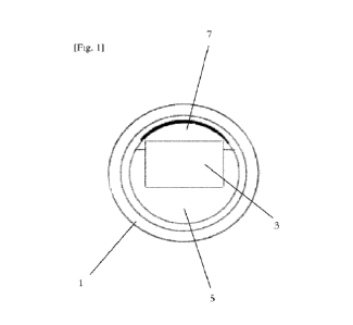
[0055] [Fig. 1] is a cross-sectional view of a carriage in a pipe.
[0056] [Fig.21 is a cross-sectional view of three pipes with
respective carriages therein.
[0057] The present invention will be described with respect to
certain drawings but the
invention is not limited thereto but only by the claims. The drawings
described are
only schematic and are non-limiting. Each drawing may not include all of the
features
of the invention and therefore should not necessarily be considered to be an
em-
bodiment of the invention. In the drawings, the size of some of the elements
may be
exaggerated and not drawn to scale for illustrative purposes. The dimensions
and the
relative dimensions do not correspond to actual reductions to practice of the
invention.
[0058] Furthermore, the terms first, second, third and the like in
the description and in the
claims, are used for distinguishing between similar elements and not
necessarily for
describing a sequence, either temporally, spatially, in ranking or in any
other manner.
It is to be understood that the terms so used are interchangeable under
appropriate cir-
cumstances and that operation is capable in other sequences than described or
il-
lustrated herein. Likewise, method steps described or claimed in a particular
sequence
may be understood to operate in a different sequence.
[0059] Moreover, the terms top, bottom, over, under and the like in
the description and the
claims are used for descriptive purposes and not necessarily for describing
relative
positions. It is to be understood that the terms so used are interchangeable
under ap-
propriate circumstances and that operation is capable in other orientations
than
described or illustrated herein.
[0060] It is to be noticed that the term "comprising", used in the
claims, should not be in-
terpreted as being restricted to the means listed thereafter; it does not
exclude other
elements or steps. It is thus to be interpreted as specifying the presence of
the stated
features, integers, steps or components as referred to, but does not preclude
the
presence or addition of one or more other features, integers, steps or
components, or
groups thereof. Thus, the scope of the expression "a device comprising means A
and
B" should not be limited to devices consisting only of components A and B. It
means
that with respect to the present invention, the only relevant components of
the device
are A and B.
[0061] Similarly, it is to be noticed that the term "connected",
used in the description,
should not be interpreted as being restricted to direct connections only.
Thus, the scope
of the expression "a device A connected to a device B" should not be limited
to
devices or systems wherein an output of device A is directly connected to an
input of
device B. It means that there exists a path between an output of A and an
input of B
which may be a path including other devices or means. "Connected" may mean
that
two or more elements are either in direct physical or electrical contact, or
that two or
more elements are not in direct contact with each other but yet still co-
operate or
7
CA 03197369 2023- 5-3
WO 2022/101762
PCT/IB2021/060326
interact with each other. For instance, wireless connectivity is contemplated.
[0062] Reference throughout this specification to "an embodiment"
or "an aspect" means
that a particular feature, structure or characteristic described in connection
with the em-
bodiment or aspect is included in at least one embodiment or aspect of the
present
invention. Thus, appearances of the phrases "in one embodiment", "in an em-
bodiment", or -in an aspect" in various places throughout this specification
arc not
necessarily all referring to the same embodiment or aspect, but may refer to
different
embodiments or aspects. Furthermore, the particular features, structures or
charac-
teristics of any one embodiment or aspect of the invention may he combined in
any
suitable manner with any other particular feature, structure or characteristic
of another
embodiment or aspect of the invention, as would be apparent to one of ordinary
skill in
the art from this disclosure, in one or more embodiments or aspects.
[0063] Similarly, it should be appreciated that in the description
various features of the
invention are sometimes grouped together in a single embodiment, figure, or de-
scription thereof for the purpose of streamlining the disclosure and aiding in
the under-
standing of one or more of the various inventive aspects. This method of
disclosure,
however, is not to be interpreted as reflecting an intention that the claimed
invention
requires more features than are expressly recited in each claim. Moreover, the
de-
scription of any individual drawing or aspect should not necessarily be
considered to
be an embodiment of the invention. Rather, as the following claims reflect,
inventive
aspects lie in fewer than all features of a single foregoing disclosed
embodiment. Thus,
the claims following the detailed description are hereby expressly
incorporated into
this detailed description, with each claim standing on its own as a separate
embodiment
of this invention.
[0064] Furthermore, while some embodiments described herein include
some features
included in other embodiments, combinations of features of different
embodiments are
meant to be within the scope of the invention, and form yet further
embodiments, as
will be understood by those skilled in the art. For example, in the following
claims, any
of the claimed embodiments can be used in any combination.
[00651 In the description provided herein, numerous specific
details are set forth. However,
it is understood that embodiments of the invention may be practised without
these
specific details. In other instances, well-known methods, structures and
techniques
have not been shown in detail in order not to obscure an understanding of this
de-
scription.
[00661 In the discussion of the invention, unless stated to the
contrary, the disclosure of al-
ternative values for the upper or lower limit of the permitted range of a
parameter,
coupled with an indication that one of said values is more highly preferred
than the
other, is to be construed as an implied statement that each intermediate value
of said
8
CA 03197369 2023- 5-3
WO 2022/101762
PCT/IB2021/060326
parameter, lying between the more preferred and the less preferred of said
alternatives,
is itself preferred to said less preferred value and also to each value lying
between said
less preferred value and said intermediate value.
[0067] The use of the term "at least one" may mean only one in
certain circumstances. The
use of the term "any" may mean "all" and/or "each" in certain circumstances.
[0068] The principles of the invention will now be described by a
detailed description of at
least one drawing relating to exemplary features. It is clear that other
arrangements can
be configured according to the knowledge of persons skilled in the art without
departing from the underlying concept or technical teaching, the invention
being
limited only by the terms of the appended claims.
[0069] [Fig.1] is a cross-sectional view of a carriage in a pipe 1.
The carriage is shown
within the pipe 1, and has an antenna 3 located in its interior. Radar-opaque
material 5
is disposed substantially around three sides of the antenna such that a
radiation beam
from the antenna is confined to a 180-degree region above the antenna 3 as
shown in
the figure.
[00701 The remaining side of the antenna 3 is surrounded by radar-
conductive material 7
such that the distance between the antenna 3 and the pipe 1 is substantially
bridged by
the radar-conductive material 7.
[0071] [Fig.2] is a cross-sectional view of three pipes 1 like
those in [Fig.1], with respective
carriages therein. The antennas are rotatable as indicated by the curved
arrows inside
the pipes. The antennas have been rotated in different rotational directions;
however,
indicated in the figure by the straight arrows are the directions at which
each antenna
has been rotated to acquire data.
[0072] The single headed arrows show directions in which
conventional radar approaches
have been taken to acquire the data; that is, each antenna acting as its own
transmitter
and receiver.
[0073] The double headed arrows show acquisition of data where one
of the antennas acts as
a receiver of radiation from another antenna (acting as transmitter).
[0074] In this way, the three radar units locate the same objects
9, using each other to cor-
roborate and/or triangulate their own positions.
9
CA 03197369 2023- 5-3