Note: Descriptions are shown in the official language in which they were submitted.
1
HYBRID SYSTEM AND METHOD OF CROP IMAGERY CHANGE
DETECTION
FIELD OF THE INVENTION
The present invention relates to a system and method for detection of
change between images, for example remotely sensed images of a crop growing in
a
field, and more particularly the present invention relates to detection of
change between
images based in part on the difference in vegetation indices between the
images to
detect changes, for example to detect changes in crop health before and after
a severe
weather event.
BACKGROUND
With an ever-growing number of available imaging platforms, it is
increasingly possible for users to get very high-frequency imagery over their
Area of
Interest (A01). Commercial satellite platforms are now capable of offering sub-
daily
revisit frequencies, and the proliferation of commercial grade unmanned aerial
platforms allows users to obtain their own imagery. However, this higher image
frequency and data complexity also means it can be impractical for users to
manually
sort through and analyze all the available data. This is especially true for
users in the
agricultural industry, commonly referred to as growers.
Remotely-sensed image data and products derived from that data (i.e.,
imagery products) are being increasingly utilized in agriculture. This is
because these
data products can provide rapid, synoptic estimates of crop health condition
over
numerous agricultural acres. Crop health condition can be estimated using
vegetation
indices derived from the original image spectral data. One example vegetation
index
is the Normalized Difference Vegetation Index (NDVI) which can demonstrate
high
correlations with crop biomass, productivity, and eventual yield. NDVI and
other
imagery products can also provide quantitative and visual indications of
deleterious
crop conditions such as pest, disease, presence of weeds, or weather-related
damage
(i.e. hail).
Despite the utility offered by these imagery products, manual inspection
of images can be very time consuming and tedious. This can be particularly
true for
Date Recue/Date Received 2023-05-31
2
growers operating very large farming operations. Manual inspection of images
and
imagery products can also require expertise and experience to properly
interpret the
data. As such, analytic tools and algorithms can help create streamlined
workflows and
products that enable users to make better data driven decisions.
Furthermore, in the instance of crop damage resulting from a weather
event for example, use of differences in vegetation indexes alone can
occasionally be
misleading as to the amount damage to the crop.
SUMMARY OF THE INVENTION
According to one aspect of the present invention there is provided a
system for crop health change monitoring of a crop growing within a field, the
system
comprising:
a memory storing programming instructions thereon; and
a computer processor arranged to execute the programming instructions
stored on the memory so as to be arranged to:
acquire a first image of the crop growing within the field at a first
point in time;
acquire a second image of the crop growing within the field at a
second point in time, in which the first point in time is prior to the second
point in time;
calculate a vegetation index difference image as a difference
between vegetation index values of the second image and vegetation index
values of
the first image;
calculate a structural similarity index measurement image by
performing a structural similarity index measurement calculation to quantify
differences
between the first image and the second image;
calculate a change layer comprising magnitude values
representing a magnitude of change between the first image and the second
image by
adding absolute difference values derived from the vegetation index difference
image
and boost values derived from the structural similarity index measurement
image; and
generate a hybrid crop health change image indicative of crop
health change by converting the magnitude values of the change layer into
positive
Date Recue/Date Received 2023-05-31
3
change values and negative change values according to corresponding difference
values of the vegetation index difference image being positive or negative.
According to a second aspect of the invention there is provided a method
for crop health change monitoring of a crop growing within a field, the method
comprising:
acquiring a first image of the crop growing within the field at a first point
in time;
acquiring a second image of the crop growing within the field at a second
point in time, in which the first point in time is prior to the second point
in time;
calculating a vegetation index difference image comprising difference
values representing a difference between corresponding vegetation index values
of the
second image and corresponding vegetation index values of the first image;
calculating a structural similarity index measurement image by performing
a structural similarity index measurement calculation to quantify differences
between
the first image and the second image;
calculating a change layer comprising magnitude values representing a
magnitude of change between the first image and the second image by adding
absolute
difference values derived from the vegetation index difference image and boost
values
derived from the structural similarity index measurement image; and
generating a hybrid crop health change image indicative of crop health
change by converting the magnitude values of the change layer into positive
change
values and negative change values according to corresponding ones of the
difference
values of the vegetation index difference image being positive or negative.
The above hybrid calculation in which differences between vegetation
indices are boosted by further differences identified through a structural
similarity index
measurement calculation, is referred to herein as a Hybrid Complex Add (HCA)
algorithm. The HCA is a means for processing and analyzing satellite imagery
to
identify changes between images on a sub-field level. By comparing satellite
images,
HCA can compute areas of change that can provide users with valuable insights
to aid
in their data driven decision making process. There are many valid
applications of the
Date Recue/Date Received 2023-05-31
4
HCA module across various industries. For simplicity and consistency purposes,
this
embodiment of the HCA module will focus on utilizing HCA in the agricultural
industry
to detect the impact of severe weather events on an agricultural field.
The hybrid crop health change image may be generated by classifying
the positive change values and the negative change values of the hybrid crop
health
change image into bins and distinguishing the bins from one another using a
color ramp.
The crop health change may be monitored relative to an event in which
said first point in time is before the event and said second point in time is
after the event.
When the event is a weather event, the hybrid crop health change image
may be generated to be representative of crop damage resulting from the
weather
event.
The method may further include: (i) acquiring a third image of the crop
growing within the field at a third point in time, in which the third point in
time is
subsequent to the second point in time; (ii) calculating a second vegetation
index
difference image comprising difference values representing a difference
between
corresponding vegetation index values of the third image and corresponding
vegetation
index values of the first image; (iii) calculating a second structural
similarity index
measurement image by performing a structural similarity index measurement
calculation to quantify differences between the first image and the third
image; (iv)
calculating a second change layer comprising magnitude values representing a
magnitude of change between the first image and the third image by adding
absolute
difference values derived from the second vegetation index difference image
and boost
values derived from the second structural similarity index measurement image;
and (v)
generating a second hybrid crop health change image indicative of crop health
change
by converting the magnitude values of the second change layer into positive
change
values and negative change values according to corresponding ones of the
difference
values of the second vegetation index difference image being positive or
negative.
The system may also generate a report that includes (i) a visual
representation of the hybrid cop health change image derived from the second
image,
(ii) a visual representation of the second hybrid cop health change image
resulting from
Date Recue/Date Received 2023-05-31
5
the third image, and (iii) a plot of average vegetation index values
associated with the
crop over time including an indication of the event, an indication of the
first point in time
of the first image, an indication of the second point in time of the second
image, and an
indication of the third point in time of the third image represented on the
plot.
The method may further include automatically selecting the first image
and the second image from a time-series of remotely sensed crop images by
comparing
the crop images to selection criteria. When monitoring crop health change
relative to
an event, preferably said first point in time is before the event and said
second point in
time is after the event, wherein the selection criteria include a date range
relative to
said event. The selection criteria may include a minimum area of interest
coverage
threshold and/or a maximum cloud or shadow coverage threshold.
The method may further include calculating an expected change in
vegetation indices between the first point in time and the second point in
time
representative of natural changes in the crop growing in the field resulting
from a natural
vegetative life cycle of the crop, and deducting the expected change in
vegetation
indices in the calculation of said vegetation index difference image.
The method may further include calculating the expected change by (i)
calculating an expected trend line as a best fit line among mean vegetation
index values
of a time-series of remotely sensed crop images of crops growing in other
fields having
similar attributes and (ii) calculating a difference between a vegetation
index value on
the expected trend line at the first point in time and a vegetation index
value on the
expected trend line at the second point in time.
The method may further include (i) calculating a field trend line as a best
fit line among mean vegetation index values of a time-series of remotely
sensed crop
images of the crop growing within the field, (ii) adjusting the vegetation
index values of
the first image such that a mean vegetation index value of the first image
falls on the
field trend line, and (iii) adjusting the vegetation index values of the
second image such
that a mean vegetation index value of the second image falls on the field
trend line.
The method may further include (i) adjusting the vegetation index values
for the first image by (a) calculating a first offset value for the first
image corresponding
Date Recue/Date Received 2023-05-31
6
to a difference between the mean vegetation index value of the first image and
the trend
line at the first point in time and (b) adding the first offset value to each
of the vegetation
index values of the first image; and (ii) adjusting the vegetation index
values for the
second image by (a) calculating a second offset value for the second image
corresponding to a difference between the mean vegetation index value of the
second
image and the trend line at the second point in time and (b) adding the second
offset
value to each of the vegetation index values of the second image.
The method may further include converting the magnitude values of the
change layer into positive change values and negative change values by: (i)
for each
magnitude value of the change layer corresponding to one of the difference
values of
the vegetation index difference image being negative, multiplying the
magnitude value
by -1; and (ii) for each magnitude value of the change layer corresponding to
one of the
difference values of the vegetation index difference image being positive,
multiplying
the magnitude value by 1.
The method may further include calculating the boost values by
subtracting pixel values in the structural similarity index measurement image
from 1.
The method may further include (i) determining if the crop is flowering in
the first image or the second image by calculating a normalized difference
yellowness
index for the image and comparing the normalized difference yellowness index
to a
flowering threshold; and (ii) if the crop is determined to be flowering in
either one of the
first image of the second image, calculating the change layer by weighting the
boost
values derived from the structural similarity index measurement image more
heavily
than the absolute difference values derived from the vegetation index
difference image.
The method may further include, if the second image is determined to be
flowering and the first image is determined to be not flowering, calculating
the boost
values by: (i) calculating an inverse layer by subtracting pixel values in the
structural
similarity index measurement image from 1; (ii) identifying a prescribed
percentile value
among inverse values within the inverse layer; (iii) subtracting the
prescribed percentile
value from each inverse value to obtain resultant values; and (iv) defining
the boost
values as absolute values of the resultant values.
Date Recue/Date Received 2023-05-31
7
The method may further include, if the second image is determined to be
flowering: (i) calculating a yellowness index change mask based on normalized
difference yellowness index values of the first image and the second image;
and (ii)
when generating the hybrid crop health change image indicative of crop health
change,
converting the magnitude values of the change layer into positive change
values and
negative change values by multiplying the magnitude values by corresponding
positive
or negative values of the yellowness index change mask.
BRIEF DESCRIPTION OF THE DRAWINGS
Some embodiments of the invention will now be described in conjunction
with the accompanying drawings in which:
Figure 1 illustrates a system environment for running HCA processes over
an agricultural field using remotely sensed image products, according to one
example
embodiment.
Figure 2 shows two valid image selection methods for Image Selection
Process.
Figure 3 represents the steps taken by the automatic image selection
process.
Figure 4 illustrates mean NDVI values of images in a time-series.
Figure 5 shows examples of RGB true color images of a selected pre-
event image, grower image, and agent image. These images were captured using
the
Dove satellite constellation. The event date of 2019-07-05 indicates the
occurrence of
a hail event over this A01.
Figure 6 illustrates the processing steps to run HCA Module.
Figure 7(a) shows the result of using SSIM calculation to compare the
pre-event image to the grower image in which the average SSIM is 0.977 and
Figure
7(b) shows the result of using SSIM calculation to compare the pre-event image
with
the agent image in which the average SSIM is 0.831. Areas with darker shades
of blue
indicate pixels with lower SSIM values (more change) and lighter blues
indicate pixels
with SSIM values approaching 1 (no change).
Figure 8(a) illustrates the ndvi_difference results between the pre-event
Date Recue/Date Received 2023-05-31
8
NDVI and the grower image NDVI by using NDVI Difference process in which the
average ndvi_difference is -0.016, and Figure 8(b) illustrates the
ndvi_difference results
between the pre-event NDVI and the agent image NDVI by using NDVI Difference
process in which the average ndvi_difference is -0.004. In preferred
embodiments, a
continuous color ramp (red-yellow-green) is stretched between min and max
values of
-0.35 and +0.35 such that green areas represent a positive change in NDVI,
while red
indicate a negative change, and light yellow areas represent pixels with
change close
to O.
Figure 9 illustrates the field trend and the expected trend. The field trend
and expected trend can be used to help reduce discrepancies between image
acquisitions while also account for natural changes of NDVI. The event
represents the
event date of a hailstorm. The field trend and expected trend were computed
using the
FACT algorithm described in the PCT patent application published under
International
Publication Number WO 2023/279198.
Figure 10 is a close-up view of Figure 9 over the months of June, July,
and August, and illustrates the process of shifting the NDVI means of the pre-
event,
grower, and agent images to fall on the field trend. This was done to help
reduce
discrepancies between image acquisitions.
Figure 11 illustrates the calculation of expected_change_agent and
actual_change_agent using the pre-event and agent image dates. Note the
actual_change is significantly smaller than the expected_change. This shows
that the
field's NDVI is not behaving as expected; indicating the event may have had a
negative
impact on the health of the crop.
Figure 12(a) illustrates the ndvi_difference results between the pre-event
NDVI and the grower image NDVI by using NDVI Difference 402 process in which
the
average ndvi_difference is -0.016; Figure 12(b) illustrates the
ndvi_difference results
between the pre-event NDVI and the agent image NDVI by using NDVI Difference
402
process in which the average ndvi_difference is -0.004; Figure 12(c)
illustrates the
unexpected change of grower NDVI after adjusting ndvi_difference by the
expected
change as outlined in process 500 in which the average unexpected change is -
0.069;
Date Recue/Date Received 2023-05-31
9
and Figure 12(d) illustrates the unexpected change of agent NDVI after
adjusting
ndvi_difference by the expected change as outline in process 500 in which the
average
unexpected change is -0.102. In preferred embodiments, a continuous color ramp
(red-
yellow-green) is stretched between min and max values of -0.35 and +0.35 such
that
green areas represent a positive change in NDVI, while red indicate a negative
change,
and light yellow areas represent pixels with change close to 0.
Figure 13(a) illustrates the ndvi_difference results between a pre-event
NDVI and a grower image NDVI by using NDVI Difference 402 process in which the
average ndvi_difference is -0.064. A continuous color ramp (red-yellow-green)
was
stretched between min and max values of -0.35 and +0.35. Green areas represent
a
positive change in NDVI, while red indicate a negative change. Light yellow
areas
represent pixels with change close to 0.
Figure 13(b) illustrates the result of using SSIM calculation to compare a
pre-event image to a grower image in which the average SSIM is 0.205. In
preferred
embodiments, areas with darker shades of blue indicate pixels with lower SSIM
values
(more change), lighter blues indicate pixels with SSIM values approaching 1
(no
change). As previously mentioned, other embodiments of HCA may utilize other
bands
to compute SSIM. In this instance, SSIM was calculated using a combination of
the
NDVI and near-infrared (NIR) band.
Figure 14(a) illustrates an NDVI difference image derived from NDVI
difference, Figure 14(b) illustrates an SSIM difference image derived from
SSIM
calculation, and Figure 14(c) illustrates an HCA image computed from the NDVI
difference image and the SSIM difference image. For visual purposes, HCA is
dynamically stretched between the min/max HCA values using a greyscale color
ramp.
Figure 15 illustrates the resulting image after classifying HCA according
to bin edges. In preferred embodiments, blue, pink, orange, and yellow
indicate areas
of poor crop health (lower HCA) in which blue indicates the areas with the
lowest crop
health (lowest HCA values), while teal colors represent areas with highest
crop health
(positive HCA values) in which compared to lighter teal colors (teal1), darker
teal colors
(tea14) represent areas with even better crop health.
Date Recue/Date Received 2023-05-31
10
Figure 16 illustrates a sample PDF that can be used to quickly display
data related to the HCA module. The PDF displays the "Event Date" for a
hailstorm
(2019-07-05). The pre-event, grower image, and agent images along with their
corresponding classified HCA images are also displayed. Change description and
area
count for each classified HCA's are present. The Field Average NDVI Trend
graphic
represents the data used to compute the unexpected change.
FIG. 17 illustrates the processes required to run the FACT Module.
FIG. 18(a) illustrates a comparison between the target trend line and the
expected trend line utilizing mean NDVI values, and including examples of
filtered data
points and inserted synthetic data points.
FIG. 18(b) illustrates a trend difference calculated as the difference
between the target trend line and the expected trend line.
FIG. 18(c) illustrates calculation of a syndex value representing an
amount of change in the trend difference shown in FIG. 18(b).
In the drawings like characters of reference indicate corresponding parts
in the different figures.
DETAILED DESCRIPTION
Referring to the accompanying figures, there is illustrated a system and
method for detection of change between images, for example remotely sensed
images
of a crop growing in a field, and more particularly for detection of change
between
images based in part on the difference in vegetation indices between the
images to
detect changes, for example to detect changes in crop health before and after
a severe
weather event.
System Environment 100. Fig. 1 illustrates a system environment for
running HCA processes over an agricultural field using remotely sensed image
products, according to one example embodiment. Within the system environment
100
is an observation system 160, network system 110, client system 140, and a
network
150 which links the different systems together. The network system 110
includes an
image store 120, Pre-processing module 130, Image selection 200, and HCA
module
400.
Date Recue/Date Received 2023-05-31
11
Other examples of a system environment are possible. For example, in
various embodiments, the system environment 100 may include additional or
fewer
systems. To illustrate, a single client system may be responsible for multiple
agricultural fields. The network system may leverage observations from
multiple
observation systems 160 to detect crop change for each of the agricultural
fields.
Furthermore, the capabilities attributed to one system within the environment
may be
distributed to one or more other systems within the system environment 100.
For
example, the HCA module 400 may be executed on the client system 140 rather
than
the network system 110.
An observation system 160 is a system which provides remotely-sensed
data of an agricultural field. In an embodiment, the remotely-sensed data is
an observed
image. Herein, an observed image is an image or photograph of an agricultural
field
taken from a remote sensing platform (e.g. an airplane, satellite, or drone).
The
observed image is a raster dataset composed of pixels with each pixel having a
pixel
value. Pixel values in an observed image may represent some ground
characteristic
such as, for example, a plant, a field, or a structure. The characteristics
and/or objects
represented by the pixels may be indicative of the crop conditions within an
agricultural
field in the image.
The observation system 160 may provide images of an agricultural field
over a network 150 to the network system 110, wherein said images may be
stored in
the image store 120. Additionally or alternatively, imagery derivatives
generated by the
pre-processing module 130, Image Selection 200, or HCA module 400, may also be
stored in the image store 120.
The pre-processing module 130 inputs an observed image and outputs a
pre-processed image. The observed image may be accessed from the image store
120
or directly received from the observation system 160. A pre-processed image is
the
observed image that has been pre-processed for Image Selection 200 and/or HCA
module 400.
The HCA module 400 uses the pre-processed image to run HCA
processes. If certain criteria are met, the HCA module will generate various
image
Date Recue/Date Received 2023-05-31
12
derivates to be transmitted to the client system 140 via a network 150.
Imagery Pre-Processing Module 130. The pre-processing of images
provided by the observation system 160 or retrieved from the image store 120
is
performed using the pre-processing module 130. Pre-processing is performed to
ensure images are suitable for use in the HCA module. Atmospheric correction
and
image filtering is the main purpose for the pre-processing module 130.
There are numerous reasons why an image may be unsuitable. Pixel
values in an observed image obtained from a remote sensing platform are a
measurement of electromagnetic radiation (EMR) originating from the sun (a
quantity
hereafter referred to as irradiance), passing through the atmosphere, being
reflected or
absorbed from objects on the Earth's surface (i.e. an agricultural field),
then what is left
passes through part or all of the atmosphere once again before being received
by a
remote sensor (a quantity hereafter referred to as radiance). The proportion
of radiance
received by a remote sensor relative to the irradiance received by these
objects (a
measure hereafter referred to as surface reflectance) is of primary interest
to remote
sensing applications, as this quantity may provide information on the
characteristics of
these objects. However, atmospheric effects can introduce detrimental impacts
on the
measured EMR signal in an observed image which can render some or all the
image
pixels inconsistent, inaccurate, and, generally, untenable for use in accurate
detection
of crop health condition changes.
Atmospheric scattering and absorption are major sources of error in
surface reflectance measurements. This effect is caused when molecules in the
atmosphere absorb and scatter EMR. This scattering and absorption occurs in a
wavelength-dependent fashion, and impacts EMR both during its initial
transmission
through the atmosphere, as well as after it is reflected from the Earth's
surface and
received by the remote sensing platform. Atmospheric absorption and scattering
can
cause various deleterious effects, including: some EMR from the sun not making
it to
objects on the ground; some EMR from the sun scattering back into the remote
sensor
before reaching the ground; some EMR reflected from the ground not reaching
the
remote sensor. While the EMR output from the sun is well understood and
relatively
Date Recue/Date Received 2023-05-31
13
invariant, atmospheric scattering and absorption can vary markedly both over
time and
space, it depends on the type and amount of atmospheric molecules, and also
depends
on the path length of the EMR transmission through the atmosphere.
One adjustment for atmospheric effects is a correction of raw image data
to top-of-atmosphere (TOA) reflectance units, a quantity hereafter referred to
TOA
reflectance. This correction converts the radiance measured by the sensor to
TOA
reflectance units expressed as the ratio between the radiance being received
at the
sensor and the irradiance from the sun, with a correction applied based on the
path of
the EMR both from the sun to the target as well as from the target to the
remote sensor.
This first order correction can mitigate for some broad temporal and spatial
attenuation
of EMR transmission from the atmosphere but does not account for the variable
absorption and scattering which can occur from variations in the atmospheric
constituent particles. It is common practice to divide TOA reflectance by
10,000 to
obtain percent reflectance.
A second order correction, referred to here as atmospheric correction,
attempts to mitigate and reduce the uncertainties associated with atmospheric
scattering and absorption. A range of atmospheric correction techniques of
varying
complexity have been employed within the field of remote sensing. These
techniques
are well known to a person skilled in the art and are consequently not further
discussed
here. The end result from atmospheric correction is an estimate of surface
reflectance.
To mitigate the impact of atmospheric scattering and absorption, in some
embodiments
the image pre-processing module 130 may employ either TOA or atmospheric
correction techniques.
Another source of uncertainty which may impact observed image quality
is the presence of atmospheric clouds or haze, and shadows cast from clouds,
which
can occlude ground objects and/or attenuate the radiance reflected from these
objects.
As such, the pre-processing module 130 may utilize a cloud and/or shadow
masking
technique to detect pixels afflicted by these effects and remove them from the
image.
Many techniques exist within the discipline for cloud and shadow masking and
are also
well known to a person skilled in the art.
Date Recue/Date Received 2023-05-31
14
The pre-processing module 130 may also remove pixels from an
observed image (e.g., using cropping, selective deletion, etc.). For example,
an
observed image may include obstacles or structures (e.g., farm houses, roads,
farm
equipment) that may be detrimental to assessment of the condition of crops
within the
field. The pre-processing module 130 may remove the impacted pixels via
cropping
them from the observed image or by flagging those pixels as invalid via a mask
layer.
Pixels impacted by clouds, shadows, and/or haze as detected by a cloud and
shadow
detection algorithm can also be removed/flagged in a similar fashion. The
resulting
image is one that provides more accurate data for analyzing crop condition.
Images that have been processed through the pre-processing module
130 are hereafter referred to as pre-processed images.
Image Selection Process 200. Image Selection Process 200, or simply
image selection, is the process of selecting images suitable for processing in
HCA
Module 400. As HCA is a module for comparing satellite images and computing
the
differences between them, a minimum of two images must be selected. In
general,
these images are referred to as a pre-event image and a post-event image. In
this
embodiment, an event refers to a calendar date that is important to the study
of the
given A01, it is usually the date that a change on the field might have
occurred; this is
referred to as the event date. This known event date allows the image
selection process
to identify an image prior to the event (pre-event image) and an image after
the event
date (post-event image). Additional pre-event and/or post-event images may be
selected and are considered as valid embodiments of Image Selection Process
200
and HCA module 400. For this embodiment of HCA, the event date corresponds to
a
hailstorm event over an agricultural field; a single pre-event image and two
post-event
images on different days will be selected. The two post-event images are
referred to as
the grower image and agent image. Ideally, these images are cloud free, have
undergone pre-processing steps as outlined in the pre-processing module 130
and
cover the same area of interest (A01). There are two valid options for image
selection:
Manual Image Selection Process 201 and Auto Image Selection Process 210. Fig.
2
illustrates the processes and methods used for Image Selection Process 200.
Date Recue/Date Received 2023-05-31
15
Manual Image Selection 201. Manual Image Selection 201, or simply
manual image selection, occurs when the user manually selects images to
compare
using HCA Module 400. A minimum of 2 images must be selected, one pre-event
and
one post-event. With manual image selection, it is up to the user to check the
quality of
selected images. Once the two images are selected, the desired pre-event and
post-
event image pair can be run through HCA Module 400.
Auto Image Selection 210. Auto Image Selection Process 210, or simply
auto image selection, is an automated process of selecting images to compare
using
HCA Module 400. To ensure only high-quality images are selected, auto image
selection performs several filtering processes to remove undesirable images
and select
images suitable for HCA Module 400. The subprocesses of Auto Image Selection
include: Image Filtering, Image Processing, Outlier Filter, and Image
Selection. Figure
3 illustrates the subprocess used in Auto Image Selection Process 210.
Image Filtering Process 211. Image Filtering Process 211, or simply
image filtering, is a processing step that filters out images that don't meet
the desired
quality control standards. The Image Filtering Process 211 is computed on the
pool of
pre-processed images as computed in the Pre-Processing Module 130. There are
several quality control metrics that can be used to filter out unsuitable or
undesirable
images from the pool of pre-processed images.
As mentioned in the pre-processing module 130, pixels can be flagged as
either cloud, and/or shadow by utilizing cloud and shadow mask techniques that
exist
and are well known within the satellite imagery industry. Image Filtering
Process 211
may utilize cloud and/or shadow masks to remove images from further
processing. For
example, images with greater than 10 percent of the pixels identified as
either cloud or
shadow could be removed from the pre-processed image pool. Furthermore, images
that do not cover at least 80% of the area of interest (A01) could also be
removed from
the pre-processed image pool.
After running Image Filtering Process 211, the remaining pre-processed
images that were not filtered out will be used in further processing steps;
these
remaining images are hereafter referred to as filtered images.
Date Recue/Date Received 2023-05-31
16
Image Processing 212. Image Processing 212, or simply image
processing, is the processing that transforms the filtered images, as produced
in Image
Filtering Process 211, into imagery derivates and discrete data values.
One embodiment of image processing may apply a calibration
correction/coefficient between images when their imagery sensors are
different. For
example, applying a calibration coefficient between a Sentinel 2 satellite
image and a
SPOT 6 satellite image will result in images that are more closely aligned in
their values.
Another example is applying a calibration coefficient between two different
satellites of
the PlanetScope constellation so that their values more closely align.
Image processing may also include the calculation of a vegetation index
(VI) for the filtered images. Vegetation indices have long been used for
remote sensing
of vegetation since they often demonstrate high correlations with vegetation
properties
of interest, such as biomass, photosynthetic activity, crop yield, vegetation
health, etc.
As an example, Image Processing 212 may compute the Normalized Difference
Vegetation Index (NDVI). The NDVI is calculated by:
Equation 1:
(NIR- Red)
NDVI = __________________________________________________
(NIR + Red)
where NIR is the image reflectance in the near infrared (NIR) band, and
Red is the image reflectance in the Red band. The NDVI is expressed as a
decimal
value between -1 and 1. NDVI values in the range of 0.2 to 0.8 or higher are
typically
considered an indication of active vegetation, with higher values being
correlated with
higher biomass, photosynthetic activity, etc. For this embodiment HCA module
400 will
utilize NDVI in its processing, however, other embodiments may utilize the
individual
bands or any other vegetation index or combination of indices.
In preparation for Outlier Filter Process 213, every filtered image must be
condensed into discrete values that represent the image as a whole. This
embodiment
of image processing will utilize the mean value of a filtered image to
represent the
images as a discrete value suitable for Outlier Filter Process 213. However,
other
Date Recue/Date Received 2023-05-31
17
statistical values may also be utilized, such as the median value of each
filtered image.
See Fig. 4 for illustration of mean NDVI values of images in a time-series.
For this embodiment, Image Processing 212 will calculate the NDVI for
each filtered image; these images will be known as either the processed images
or the
NDVI images. The mean NDVI values calculated from each processed image are
hereafter referred to as the mean NDVI values and will be utilized by Outlier
Filter
Process 213 and later in NDVI Adjustment 500.
Trend Module 300. Trend Module 300 is a least-square regression
algorithm that takes an array of data values and other user defined parameters
to
compute a best fit line for the data. Trend Module 300 is utilized by Outlier
Filter
Process 213. There are many open-source models and algorithms to do this
computation. The Savitzky-Golay filter and locally weighted scatterplot
smoothing
(LOWESS) are just a few examples of commonly used algorithms used to compute a
best fit line, or trend line, for an array of data values. For this
embodiment, the Savitzky-
Golay filter as documented and computed in Scipy's signal processing module
will be
used with a polynomial order of 3. Any best fit lines produced using any valid
Trend
Module 300 algorithm will be referred to as the trend or trend line of the
data. See fig.
4 for an example of a trend line computed using Trend Module 300.
Outlier Filter Process 213. The Outlier Filter Process 213, or simply
outlier filter, is the process of identifying mean NDVI values in a time-
series that are
divergent from the trend and flag them as outliers. Outlier mean NDVI values
will be
flagged as 'rejected' and the corresponding processed NDVI images will be
excluded
from future processes. See fig. 4 for example of 'rejected' images in red. The
outlier
filter utilizes the Trend Module 300 to compute a trend line for a mean NDVI
time-series.
One embodiment of Outlier Filter Process 213 passes a dynamic window size to
Trend
Module 300. The window size is calculated by:
(length(mean_NDVI_values))
500
Equation 2: int(window) = * 101
This is just one method of calculating the window size. Any other methods
Date Regue/Date Received 2023-05-31
18
or a static window size is optional. Trend Module 300 requires the window size
to be an
odd number; therefore if the result of Equation 2 is even, +1 is added to the
window.
Once a trend line is computed, each NDVI value used to compute the
trend is assigned a NDVI_trend_difference value. The NDVI_trend_difference
value is
calculated by taking the difference between the mean NDVI value and the trend
value
at a given point.
Equation 3: NDVI_trend_difference = mean_NDVI_value ¨ trend_value
If the NDVI_trend_difference value for a mean NDVI exceeds a critical
threshold it will be flagged as an outlier ('rejected') in the mean NDVI
dataset and should
be ignored in any future HCA processes. For this embodiment of HCA, the
critical
.. NDVI_trend_difference thresholds of -0.05 and +0.07 were used. The
resulting mean
NDVI time-series dataset is now free of outlier data points that may impact
future
processing and will be hereafter referred to as the mean NDVI values. See fig.
4 for
examples of accepted mean NDVI values in a timeseries, a trend line as
computed by
Trend Module 300, NDVI_trend_difference, and rejected images as a result of
the
outlier filter process.
Other potential outlier filter methods exist and should be considered as
potential HCA embodiments. Images not rejected by the outlier filter process
are
considered as accepted images and are hereafter referred to as filtered
images.
Image Selection Process 214. Image selection process 214, or simply
image selection, is a processing step that selects images suitable for further
processing
from the pool of filtered images. As discussed in Image Selection Process 200,
a
minimum of two images are selected around an event date; the selected images
are
referred to as the pre-event and post-event images. Image Selection Process
214 will
identify the pre-event and post-event images from the pool of filtered images.
For this
embodiment, the event date corresponds to a hail event over an agricultural
field on
July 5, 2019; a single pre-event image and two post-event images will be
selected. The
two post-event images are referred to as the grower image and agent image
respectively. The logic used to identify the pre-event, grower, and agent
images are
Date Recue/Date Received 2023-05-31
19
described below.
Pre-event Image Selection. A pre-event image is any filtered image that
occurs prior to the given event date. For this embodiment, a pre-event image
candidate
is an image that meets the following selection criteria: (i) Pre-event image
must occur
between 1-7 days prior the event date. (ii) A minimum A01 coverage of 90%. A01
coverage is computed by pre-processing module 130. (iii) A maximum of 5%
cloud/shadow covered pixels. Cloud and shadow cover is computed by pre-
processing
module 130.
If multiple pre-event image candidates are identified, the image with the
maximum NDVI is selected as the pre-event image.
Additional or variations of the pre-event image selection criteria are
acceptable. If desired, users may bypass the automated pre-event image
selection by
manually selecting a pre-event image.
Grower Image Selection. For this embodiment of image selection, the
grower image is a filtered image that meets specific filtering criteria. If a
filtered image
meets the following criteria, it is considered a grower image candidate. (i)
Grower image
must occur after the provided event date. (ii) A maximum of 3 days of
separation
between the event date and the grower image. (iii) A minimum of 1 days of
separation
between the event date and the grower image. (iv) A minimum A01 coverage of
90%.
A01 coverage is computed by pre-processing module 130. (v) A maximum of 5%
cloud/shadow covered pixels within the grower image. Cloud and shadow cover
(Cloud_Cover) is computed by pre-processing module 130.
If there are multiple grower image candidates, a selection algorithm is
applied to select the optimal image. This selection metric uses the NDVI
standard
deviation as well as the percent cloud cover. The selection process is as
follows:
(i) Calculate the average NDVI standard deviation (NDVI_stdDev) from
all candidate images.
(ii) For each grower image candidate, compute the Cloud-Calibrated
NDVI Variance Index (CON VI) by:
Date Recue/Date Received 2023-05-31
20
Equation 4:
CCNVI = NDVI_stdDev ¨ (Cloudcover * 0.5 * ava
ci N DVI stdDev )
(iii) Select image with the highest CCNVI value. This is the grower image.
Additional or variations of the grower selection criteria are acceptable. If
desired, users may bypass the automated grower image selection by manually
selecting a post-event image as the grower image.
Agent Image Selection. For this embodiment of image selection, the
agent image is a filtered image that meets specific filtering criteria. If a
filtered image
meets the following criteria, it is considered an agent image candidate. (i)
Agent image
must occur after the provided event date. (ii) A minimum A01 coverage of 90%.
A01
coverage is computed by pre-processing module 130. (iii) A maximum of 5%
cloud/shadow covered pixels within the agent image. Cloud and shadow cover is
computed by pre-processing module 130. (iv) A minimum of 4 days of separation
between the event date and the agent image. (v) A maximum of 12 days of
separation
between the event date and the agent image. (vi) First, try to select an agent
image that
occurred within the window of 9 to 12 days after the event date. (vii) If no
valid agent
image is found, incrementally increase the window size to allow image dates
closer to
the event date until at least one image meets the agent image selection
criteria. (ie: 8-
12 days after event date, 7-12, 6-12, ...4-12).
If multiple agent image candidates are found, the same selection logic
from grower image selection using CCNVI is applied. See Equation 4.
Additional or variations of the agent selection criteria are acceptable. If
desired, users may bypass the automated agent image selection by manually
selecting
a post-event image as the agent image.
Running the image selection process results in the selection of pre-event
and post event image(s). These pre-event and post event image(s) will be
compared
using HCA Module 400. As long as a pre-event is being compared to a post-event
image, various combinations and numbers of pre-event and post-event images are
suitable for HCA module. As previously stated, this embodiment will
individually
Date Regue/Date Received 2023-05-31
21
compare a single pre-event image to two post-event images ¨ grower image and
agent
image. Fig 4. Illustrates the location of the pre-event and post-event images
in a
timeseries.
Fig. 5 shows examples of a selected pre-event image, grower image, and
agent image. The pre-event and agent images were selected via Auto Image
Selection
210; the grower image was manually selected via Manual Image Selection 201.
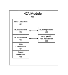
HCA Module 400. Hybrid Complex Add (HCA) Module 400 may be
referred to as HCA module or simply HCA. The HCA module is a means for
processing
and analyzing satellite imagery to identify changes between images. Images
selected
via Image Selection 200, or any other method of image selection, can be used
as input
images for the HCA module. For this embodiment, the HCA module will utilize
the pre-
event, grower, and agent images selected in Auto Image Selection 210. The HCA
module will be used to compare the pre-event and grower image, as well as the
pre-
event and agent image. Fig. 6 illustrates the processing steps to run HCA
Module 400.
Structural Similarity Index Measurement Calculation 401. Structural
Similar Index Measurement (SSIM) 401, or SSIM, is an objective method for
quantifying
the visibility of differences between a reference image and a distorted image.
Structural
Similarity Index Measurement (SSIM) was first published in IEEE Transactions
on
Image Processing, Vol 13, No. 4, April 2004. The title of the paper is Image
Quality
Assessment: From Error Visibility to Structural Similarity [2]. SSIM is an
objective
method for quantifying the visibility of differences between a reference image
and a
distorted image using a variety of known properties of the human visual system
[2].
Therefore, by utilizing SSIM we can compare and compute the differences
between our
pre-event (reference image) and post-event image (distorted image) in the HCA
module.
This embodiment of HCA module will use the NDVI values of the pre-
event and post-event images to compute SSIM. However, other satellite bands or
vegetation indices or combination thereof are valid. The SSIM of the pre-event
image
(x) and post-event image (y) is calculated using the following equation [2]:
Equation 5:
Date Regue/Date Received 2023-05-31
22
(2ux uy + cl)(2axy +c2)
=
(14 + uj, + ci)(ci + ci3 + c2)
Where:
= x the NDVI of the pre-event image
= y the NDVI of the post-event image
= ux the average of x
= uy the average of y
2
= (fx. the variance of x
= o-3 the variance of y
= o-xy the covariance of x and y
The resulting SSIM image illustrates the differences between the pre-
event image and the post-event image. SSIM values range from -1 to 1. SSIM
values
closer to 1 indicate pixels with higher similarity between the pre-event image
and post-
event image; values closer to -1 indicate a larger change/difference between
pre-event
and post-event images. A SSIM value can be computed for every pixel by
utilizing a
moving window which moves pixel-by-pixel over the entire image; one such
filter is the
gaussian filter proposed in [2].
The resulting image created by computing SSIM over an entire image
(pixel-by-pixel), will hereafter be referred to as the SSIM image. Images
created by
computing SSIM over an entire image using SSIM process 401 are hereafter
collectively referred to as SSIM images or, more specifically, grower SSIM and
agent
SSIM which are calculated on the grower and agent image respectively. Fig. 7
shows
the resulting SSIM images after comparing the pre-event to the grower and
agent
images.
As demonstrated, SSIM is useful in quantifying and identifying areas of
change between a pre-event and post-event image. However, in terms of
vegetation
health, SSIM is unable to indicate whether that change had a positive or
negative
impact on the vegetation. Thus, another variable was used to gauge the
positive or
negative implications of the change on vegetation health, as described in NDVI
Difference 402 below. As previously described, NDVI can act as a good
indicator for
vegetation health.
NDVI Difference 402. NDVI Difference 402 is the process of computing
Date Recue/Date Received 2023-05-31
23
the NDVI difference between the pre-event image and the post-event image. The
NDVI
for the pre-event and each post-event image can be calculated by using
equation 1.
NDVI difference is calculated by subtracting the NDVI of the pre-event image
from the
post-event image.
Equation 6: ndvi_dif ference = ndvi_postEvent ¨ ndvi_preEvent
By calculating the NDVI difference we can identify areas where the NDVI
increased, decreased, or stayed relatively the same. Fig. 8 illustrates the
results of
running process 402, NDVI Difference, between the pre-event and post-event
images.
Images created by running process NDVI Difference 402 are hereafter
collectively referred to as NDVI difference images or, more specifically,
grower NDVI
difference and agent NDVI difference. There is an optional step that can be
completed
prior to computing grower NDVI difference and agent NDVI difference; see NDVI
Adjustment 500 for details on shifting image means to the field trend.
NDVI Adjustment 500.
NDVI Adjustment 500, or simply NDVI
Adjustment, is the optional process of adjusting the ndvi_difference as
computed in
NDVI Difference 402. NDVI adjustment is used to account for natural/expected
changes
of NDVI within a crop's vegetative life cycle. It may also help to reduce
potential
discrepancies between images due to satellite calibrations, atmospheric
differences, or
other various sources of noise that may have been un-accounted for in pre-
processing
module 130 or other filtering processes previously mentioned.
One optional method to help reduce discrepancies between images is to
utilize trends computed from a NDVI timeseries. The field trend will help
reduce
discrepancies between image acquisitions while an expected trend can help
account
for natural changes of NDVI within a crop's life cycle. See Fig. 9 for
examples of a field
trend and expected trend.
The field trend (field_trend) is the trend line computed for mean NDVI
image values in a timeseries over a single target field (A01); see Fig. 9 for
example for
field trend. The field trend can help reduce discrepancies between images by
shifting
an image's mean to fall on the field trend value for the image date. To shift
an image's
Date Regue/Date Received 2023-05-31
24
mean to the trend's mean, the trend_offset must be computed and then added to
each
pixel in the image. This results in a new image referred to as the
image_shifted_mean,
or simply the shifted image. The mean value of the shifted image
(image_shifted_mean)
will match the mean trend value on a given date (x). Equation 7 shows how to
calculate
the image_shifted_mean.
Equation 7: trend_offset = trend _mean x ¨ image_meanx
image_shifted_meanii = imagepixelij trend_offset
Where:
= trend_meanx the NDVI value of the trend at date (x)
= image_meanx the NDVI value of the image at date (x)
1 0 = imagepixeiti the NDVI value of a pixel (i,j) in the image
For example, in Fig. 10, the pre-event image has a mean NDVI of 0.41,
while the field_trend is 0.39. Thus, the resulting trend_offset is -0.02 and
after all pre-
event image pixels have been adjusted with the trend_offset the new mean NDVI
of the
shifted pre-event image (image_shifted_mean) is 0.39. The results of applying
the
same logic to the grower and agent image is a shifted grower image with a new
NDVI
mean of 0.41 and a shifted agent image with a new NDVI mean of 0.43. Applying
the
same logic to the grower image results in a shifted grower image with the mean
NDVI
value changing from 0.40 4 0.41. The mean NDVI of the agent image shifts from
0.41
4 0.43. See Fig. 10 for graphical representation of shifting pre-event, grower
and agent
image means to the field trend.
It is optional to shift image means to fall on the field trend values;
however,
for this embodiment, the shifting of image means to the field trend occurs on
the pre-
event, grower, and agent images. This step occurs prior to calculating the
grower NDVI
difference and agent NDVI difference (Fig. 8). After applying the mean image
shift to
the pre-event, grower, and agent images, they will be hereafter referred to as
either the
shifted pre-event, shifted grower, and shifted agent images, or simply the pre-
event,
grower, and agent images.
As previously mentioned, NDVI trends can be used to account for
Date Regue/Date Received 2023-05-31
25
natural/expected changes of NDVI within a crop's vegetative life cycle; this
is done by
utilizing the field trend and expected trend. The expected trend is the trend
line for mean
NDVI values in a timeseries over multiple fields that have similar
characteristics with
the target field. If a field has sufficient similar characteristics to that of
the target field, it
can be referred to as a candidate field. For example, if the target field is
an irrigated
wheat field, all candidate fields must also be irrigated wheat fields. Other
characteristics
or properties may be used to identify the ideal candidate fields; such as
spatial proximity
to the target field (ie: a candidate field must be within X distance from the
target field).
Once all potential candidate fields are identified, the expected trend is
computed using
the mean NDVI image values from all candidate fields. See Fig. 9 for example
of
expected trend. The expected trend is a representation of what a typical (or
expected)
NDVI trend should look like for the target field. The Field Average Crop Trend
(FACT)
algorithm is a series of processes that can be used to compute the expected
trend as
disclosed in the PCT patent application published under International
Publication
Number WO 2023/279198. A summary of the FACT algorithm is provided below. For
this embodiment, the FACT algorithm was used to compute the Field Trend and
Expected Trend as shown in Fig. 9.
By utilizing the expected trend, we can calculate the amount of change to
expect over a given period; this is referred to as expected change
(expected_change).
The expected change over a given period (x1, x2) can be calculated by:
Equation 8: expected_change,1,x2 = y2_expectedx2 ¨ Y1_expectedx1
Where:
. Yl_expectedxi the NDVI value of the expected trend on date (X1)
. Y2_expectedx2 the NDVI value of the expected trend on date (x2)
Similarily, by utilizing the field trend, we can calculate the amount of
actual
change that occurred over a given period; this is referred to as actual change
(actual_change). The actual change over a given period (x1, x2) can be
calculated by:
Equation 9:
Date Regue/Date Received 2023-05-31
26
actual _chang exi,x2 = 372_actuaix2 ¨ Yl_actualx 1
Where:
. Yi_actuazxi the NDVI value of the field trend on date (X1)
. Y2_actuazx2 the NDVI value of the field trend on date (x2)
By using equations 8 & 9 we can calculate the actual and expected
change between the pre-event image (x1) and agent image (x2). These will be
referred
to as the actual_change_agent and expected_change_agent respectively. See the
calculations below and Fig. 11 for illustrations on calculating expected and
actual
change between the pre-event and agent images.
expected_chang e ag ent = 0.49 ¨ 0.35 = 0.14
actual _chang e ay ent = 0.43 ¨ 0.39 = 0.04
Likewise, the expected_change_grower and actual_change_grower can
be calculated by following the same methods used to calculate
expected_change_agent and actual_change_agent.
The expected_change and actual_change can then be utilized to
calculate the unexpected NDVI change (unexpected_change). Unexpected change is
the change that occurs between images that cannot be contributed to natural
growth or
senescence of a crop's lifecycle. Unexpected change can be calculated by:
Equation 10: rtexpected_chang e = actual_chang e ¨ expected_change
Therefore, the unexpected change for the example pre-event and agent
image pair (unexpected_change_agent) is:
unexpected _chang eagent = 0.04 ¨ 0.14 = 0.10
The unexpected change can be calculated at the pixel level for an image
by simply subtracting the expected_change from every NDVI pixel.
Date Recue/Date Received 2023-05-31
27
Unexpected_change can also be calculated at that the pixel level for an
image. To do so, the ndvi_difference between the pre-event and post-event
image must
be calculated first (see NDVI Difference 402 process and optional
image_shifted_mean
process in NDVI Adjustment 500). The unexpected_change can then be calculated
by
subtracting the expected change from every ndvi_difference pixel (ij) value as
shown
below:
unexpected_changeii = ndvi_dif ferenceii ¨ expected_change
By subtracting the unexpected_change from both the grower NDVI
difference and agent NDVI difference (shown in Fig. 8) we can compute the
grower
unexpected change and agent unexpected change images as shown in Fig. 12. The
resulting grower and agent unexpected change images now reflect a more
accurate
representation of NDVI changes because they adjust NDVI for discrepancies
between
image acquisitions by shifting image means to the field trend, while also
adjusting for
natural changes in NDVI by accounting for expected change.
The NDVI Adjustment 500 and its subsequent components are optional.
However, if this optional process is utilized, the derived grower unexpected
change and
agent unexpected change images replace the ndvi_difference images in
subsequent
processing steps. Thus, further references to ndvi_difference images may be a
direct
reference to the unexpected change images as calculated in NDVI Adjustment
500. For
this embodiment, NDVI Adjustment 500 and its subsequent components are
utilized,
therefore, unexpected change images are hereafter referred to as
ndvi_difference
images.
HCA Calculation 403. Hybrid Complex Add (HCA) Calculation 403, or
simply HCA, is the process of calculating HCA by utilizing the SSIM and
ndvi_difference
images previously computed. The resulting HCA image will show areas of change
between the pre-event and post-event image while also being able to classify
those
changes as either positive or negative impacts to the crop's health.
To incorporate SSIM, the SSIM_boost value must be computed for each
Date Recue/Date Received 2023-05-31
28
pixel (0); see equation 11. Computing the SSIM_boost value for every pixel
results in
the SSIM_boost_image. Since SSIM values range from -1 to +1, the
SSIM_boost_image values will range from 0 to 2. A SSIM value of 1 indicates
there is
no change between the two images; thus, the SSIM_boost value is 0 (no boosting
power). The SSIM_boost value is used to boost the signal within the
ndvi_difference
image.
Equation 11: SS1M_boost1,1 = 1 ¨ SS/M1,1
Where:
= SS/M,1 the SSIM value at pixel (0)
As previously mentioned, SSIM only detects changes within an image, it
does not classify those changes as either good or bad; the same is true for
the
SSIM_boost. However, SSIM has proven to detect changes between images that are
not detected in ndvi_difference. Fig. 13 demonstrates the power of SSIM to
detect
changes between images not seen in NDVI. Thus, by utilizing SSIM we can create
a
SSIM_boost image to boost smaller changes in ndvi_difference.
To incorporate the SSIM_boost values into the ndvi_difference image we
must first create a boolean mask of the ndvi_difference image; this mask will
be referred
to as the ndvi_change_mask. The ndvi_change_mask will contain values of either
-1
or +1. Any negative values in the ndvi_difference image will be assigned a -1
value in
the ndvi_change_mask; while any positive values in the ndvi_difference image
will be
assigned a +1 value.
Next, the change_layer is created. The change layer is a measure of the
magnitude of change between the images. The change_layer is calculated by
adding
SSIM_boost to the absolute value of the ndvi_difference:
Equation 12: change_layer = Indvi_differencel + SSIM_boost
Finally, HCA can be calculated by applying the ndvi_change_mask to the
change_layer. By doing so, we can assign positive or negative values to the
change_layer; indicating whether the change was good (positive) or bad
(negative).
Date Regue/Date Received 2023-05-31
29
See equation 13 for how to calculate HCA and Fig. 14 for example of HCA image
output.
Equation 13: HCA = change_layer * ndvi_change_mask
A negative HCA value signifies a lower-than-expected change in that
pixel; while a positive HCA value indicates a higher-than-expected change in
that pixel.
In terms of agricultural crop condition, negative HCA values indicate the
crop's health
is lower than expected, while positive HCA values indicate crop health is
exceeding
expectations. Lower HCA values mean poorer crop health and higher HCA values
mean better crop health. HCA values close to 0 indicate areas where the crop
health
is performing as expected.
Crop Specific HCA Adjustment 600. Crop Specific HCA Adjustment 600
is the process of adjusting the HCA calculation based on specific crop types.
This step
is optional but can improve HCA results. For example, Crop Specific HCA
Adjustment
600 may be applied for canola fields if one or both of the images being
compared (pre-
image or post-image) show flowering. To determine if a field is flowering in
either the
pre-event or post-event image(s), the Normalized Difference Yellowness Index
(NDYI)
is used. NDYI is calculated by utilizing the green and blue bands of the image
in the
following equation:
(Green- Blue)
Equation 14: NDYI = _____________
(Green+ Blue)
The image is classified as flowering if 75% of the pixels reach or exceed
a specified NDYI threshold. For this embodiment, an NDYI threshold of 0.02 is
used.
If either the pre-event or post-event image is flowering, the following
modified HCA
Calculation logic may be performed instead of running Hyrbid Complex Add (HCA)
Calculation 403.
Like HCA Calculation 403, Crop Specific HCA Adjustment utilizes the
SSIM and ndvi_difference images previously computed. The resulting HCA image
will
show areas of change between the pre-event and post-event image while also
being
Date Recue/Date Received 2023-05-31
30
able to classify those changes as either positive or negative impacts to the
crop's
health. The HCA logic will change depending on whether one or both the
pre/post-
event images are flowering.
First, the SSIM_boost is calculated. If the post-event image is flowering
and not the pre-event; SSIM_boost is computed by equations 15 & 16. Otherwise,
SSIM_boost is calculated by equation 11.
Equation 15: inverse_ssimiJ =1¨ SSIMQ
Equation 16: SSIM_boostiJ =Iinverse_ssimiJ ¨ P0.9(inverse_ssim)I
Where:
= P0.9(inverse_ssim) is the 90th percentile of inverse_ssim
Additionally, any SSIM_boost values from equation 16 that exceed a
value of 0.2 are lowered to the value of 0.2; thus 0.2 is the cap SSIM_boost
value
following equation 16.
Next, the NDYI change maskis computed. If the post-event image is
flowering, the NDYI change mask is computed by equations 17-19.
Equation 17: ndyi_diff = ndyipostEvent ¨ ndyi preEvent
Equation 18: ndyi_postEvent_norm = ndyi
-postEvent ¨ median(ndyipostEvent)
Equation 19: ndyi_posneg = min(ndyi_diff,ndyi_postEvent_norm)
Where:
= ndyi
-postEvent is the NDYI of the post-event image
= ndyipreEvent is the NDYI of the pre-event image
= median(ndyi
-postEvent) is the median value of ndyi
-postEvent
= min(ndyi_diff,ndyi_postEvent_norm) is smallest/lowest between ndyi_diff
Date Regue/Date Received 2023-05-31
31
and ndyi_postEvent_norm
Additionally, if only the pre-event image is flowering and there is less than
days between the pre-event and post-event images, the NDYI change maskis also
computed by equations 17-19.
5
Once ndyi_posneg is determined, the NDYI change mask is computed by
creating a boolean mask of the ndyi_posneg image. If ndyi_posneg is not
computed
due to neither the pre-event nor post-event images meeting the above flowering
conditions, the ndvi_change_mask will be computed using the ndvi_difference
image
as described in HCA Calculation 403. The ndvi_change_mask will contain values
of
10
either -1 or +1. Any negative values in the ndyi_posneg image will be assigned
a -1
value in the ndvi_change_mask; while any positive values in the ndyi_posneg
image
will be assigned a +1 value; no-data values will remain as no-data values.
Next, the change_layer is created. The change layer is a measure of the
magnitude of change between the images. If either the pre-event or post-event
images
are flowering, the change_layer is calculated by equation 20; otherwise, the
change layer
is calculated as described in HCA Calculation 403.
Equation 20 change_layer = (Indvi_dif ferencel* 0.5) + SSIM_boost *
1.5
HCA is then calculated as normal by following equation 13. A final step to
clean up the HCA image can be applied; any pixels in the ndyi
-postEvent image with a
NDYI value greater than 0.08 are considered invalid and are therefore given a
HCA
value of 0Ø
HCA Classification 404. HCA Classification 404, or simply HCA
classification, is the process of classifying the HCA image based on desired
thresholds.
This is an optional step that can help condense HCA images and make them
easier to
interpret. For this embodiment, the HCA image is classified into 9 bins using
the
following bin edges [-0.7, -0.45, -0.15, -0.05, 0.1, 0.2, 0.45, 0.7]. The
first bin being any
HCA value less-than -0.7 and the last bin containing HCA values greater-than
0.7.
These 9 bins correspond to the following colors: blue, pink, orange, yellow,
white, tea11,
Date Regue/Date Received 2023-05-31
32
teaI2, teaI3, tea14; where teal1 is the lightest shade of teal and teal 4 the
darkest. Each
color can be linked to a change descriptor that can be used to indicate the
current crop
health status (Fig. 15). Other embodiments of HCA may utilize other bins and
colors
and are considered valid. See Fig. 15 for example of a classified HCA image,
the
corresponding colors, and the change description for each color/bin.
PDF Report 405. PDF Report 405, is the process of creating a PDF report
to display data relating to the HCA module in such a way that allows users to
quickly
digest its valuable information. This is an optional step and simply
illustrates a method
for displaying the HCA module results. The PDF report may be displayed in the
Observation System 160 and/or the Client System 140. Other methods/process for
displaying HCA results are considered as valid embodiments of the HCA module.
See
Fig. 16 for an example PDF report.
Field Average Crop Trend (FACT) module 1200. The following description
provides a summary of the FACT algorithm referenced above. The Field Average
Crop
Trend (FACT) module is a component of the network system 110 and is a means
for
computing and analyzing time-series data of satellite imagery to provide users
with
valuable insights to make data driven decisions. The processed required to run
the
FACT module are illustrated in FIG. 17. FACT Module 1200 may be referred to as
FACT module or simply FACT. The FACT module is a means for computing and
analyzing time-series data of satellite imagery over agricultural fields to
provide users
with valuable insights to make data driven decisions. FACT can utilize any
satellite
sensor bands or any indices derived from those bands in its processes and
analysis.
For simplicity and consistency purposes, this embodiment of the FACT will
utilize NDVI
time-series data from a target field and candidate fields.
The target field is the agricultural field upon which the user desires to gain
valuable insights. Candidate fields are agricultural fields that share similar
attributes
with the target field. Some similar attributes the target and candidate fields
may share
are: crop type, spatial proximity, soil characteristics, irrigation practices,
etc. By utilizing
NDVI time-series data over the target field, FACT can create a target trend
that reflects
daily NDVI averages over the target field; candidate trends can be computed
with
similar process over candidate fields. When candidate trends are combined into
a
Date Recue/Date Received 2023-05-31
33
single trend it will be referred to as the expected trend. By analyzing the
relationship
between the NDVI trend of the target field (target trend) and the combined
NDVI trends
of the candidate fields (expected trend) we can gain valuable insights between
these
two signals. Such insights may include growth stage development, rates of
change
(e.g., green-up and senesce rates), crop condition, weather events, crop
predictions
such as yield, and more. These insights not only allow growers to make data
driven
decisions regarding their agricultural operation, but it also helps streamline
their daily
workflows and productivity. Furthermore, the data and analytics computed by
FACT
can enable other agricultural analysis, such as detecting anomalies (e.g.,
crop stress)
within afield.
Candidate Filtering Process 1201
Candidate Filtering Process 1201, or simply candidate filtering, is the first
processing step in FACT module 1200. Candidate filtering is the process of
classifying
a candidate field as either a valid or invalid candidate field. Classification
of a candidate
field as either valid or invalid is based on how closely a candidate field's
attributes match
those of the target field. For this embodiment of FACT, we will assume a
hypothetical
target field has the following attributes: (i) Crop: Canola; (ii) Seed
variety: DKTC 92 SC;
(iii) Seeding date: May 22, 2019; (iv) Irrigated: False; (v) Soil: Loam; (vi)
Location: X,Y
(latitude/longitude of field centroid); (vii) Temperature/weather data: True;
and (viii) Hail
.. date: July 15, 2019.
A target fields attributes are in no way restricted to the above attribute
list;
any other potential field attributes may be added (or removed) from a field
attribute list
and would be considered valid attributes.
For this embodiment, FACT will assume any candidate fields that have
the same crop, are within D distance from location X, Y, and have daily
temperature and
weather data are valid candidate fields. The variable D is the maximum
distance from
which the candidate field can be from the target fields location of X, Y. One
embodiment
of FACT allows for an iterative approach to gradually increase the size of D
until a
minimum number of good candidate fields are identified. User discretion is
used to
determine the size of D and the minimum required candidate fields. For this
embodiment we will assume a maximum search distance D of 100km and a minimum
of 1 required candidate field. Any candidate fields identified as invalid
through the
Date Recue/Date Received 2023-05-31
34
candidate filtering process will not be used in further FACT analysis. At
least 1
candidate field must be considered as valid for FACT processing to continue.
Image Selection Process 1202
Image Selection Process 1202, or simply image selection, is the process
of selecting images from the pool of pre-processed images as computed in Pre-
Processing Module 130. A pre-processed image can be classified as either valid
or
invalid based on image selection criteria. One embodiment of FACT may use
percent
field coverage and/or percent invalid pixels of the pre-processed image as
image
selection criteria. Percent field coverage refers to the percentage of field
that is covered
by the pre-processed image. Percent invalid pixels refers to the percentage of
pixels
in the pre-processed image, within the candidate field or target field, that
are
classified/flagged/removed/deleted or otherwise deemed invalid by the Pre-
Processing
Module 130. If a pre-processed image does not meet the percent field coverage
and/or
percent invalid pixels thresholds, set at the user's discretion, it is
considered invalid and
removed from further processing by FACT. For example, one embodiment of FACT
indicates that a valid pre-processed image must cover at least 50% of the
field and
include no more than 5% invalid pixels; however, other thresholds can be used
while
still yielding effective results. Pre-processed images that are considered
valid by Image
Selection Process 1202 will be hereafter referred to as selected images.
Image Processing 1203
Image Processing 1203, or simply image processing, is the process of
transforming the selected images (as produced by Image Selection Process 1202)
into
imagery derivates and discrete data values suitable for time-series analysis.
One embodiment of FACT image processing may apply a calibration
correction/coefficient between selected images where their imagery
source/sensors are
different. For example, applying a calibration coefficient between a Sentinel
2 satellite
selected image and SPOT 6 satellite selected image are more closely aligned in
their
values. Another example is applying a calibration coefficient between Dove-
classic and
Dove-R satellites.
Image processing may also include the calculation of a vegetation index
(VI) for the selected images. Vegetation indices have long been used for
remote
sensing of vegetation since they often demonstrate high correlations with
vegetation
properties of interest, such as biomass, photosynthetic activity, crop yield,
etc. As an
Date Recue/Date Received 2023-05-31
35
example, Image Processing 1203 may compute the Normalized Difference
Vegetation
Index (NDVI). The NDVI is calculated by:
(NIR - Red)
NDVI = ____________________________________________
(NIR + Red)
where NIR is the image reflectance in the near infrared (NIR) band, and Red is
the
image reflectance in the Red band. The NDVI is expressed as a decimal value
between
-1 and 1. NDVI values in the range of 0.2 to 0.8 or higher are typically
considered an
indication of active vegetation, with higher values being correlated with
higher biomass,
photosynthetic activity, etc. For this embodiment FACT will utilize NDVI in
its
processing, however, other embodiments may utilize the individual bands or any
other
vegetation index or combination of indices.
In order for selected images to be suitable for time-series analysis, Image
Processing 1203 must condense the selected images into single discrete values.
This
embodiment of FACT will utilize the mean value as a method of condensing the
selected image into a discrete value suitable for time-series analysis.
However, other
embodiments may also be utilized such as the median value of each selected
image.
For this embodiment of FACT, Image Processing 1203 will calculate the
NDVI for each selected image and then calculate the mean NDVI value for each.
The
mean NDVI value of each selected image will be utilized by subsequent FACT
processes and will be simply referred to as the mean NDVI value. See FIG. 18a
for
examples of mean NDVI values.
Trend Module 1220
Trend Module 1220 is a least-square regression algorithm that takes an
array of data values and other user defined parameters to compute a best fit
line for the
data. There are many open-source models and algorithms to do this computation.
The
Savitzky-Golay filter and locally weighted scatterplot smoothing (LOWESS) are
just a
few examples of commonly used algorithms used to compute a bit fit line, or
trend line,
for an array of data values. For this embodiment of FACT, the Savitzky-Golay
filter as
documented and computed in Scipy's signal processing module
(scipy.signal.savgol_filter) will be used with a polynomial order (polyorder)
of 3. The
Date Recue/Date Received 2023-05-31
36
window_length parameter determines the number of coefficients and the values
varies
depending on which FACT process is being run. Any best fit lines produced
using any
valid Trend Module 1220 algorithm will be referred to as the trend or trend
line of the
data.
Outlier Filter Process 1204
The Outlier Filter Process 1204, or simply outlier filter, is the process of
filtering/flagging
mean NDVI values, as computed by Image Processing 1203, as outliers or not.
The
outlier filter utilizes the Trend Module 1220 to compute a trend line for a
mean NDVI
time-series. One embodiment of Outlier Filter Process 1204 passes a dynamic
window
size to Trend Module 1220. The window size is calculated by:
(length(mean_NDVI_values))
int(window) = ________________________________ 500 * 101
This is just one method of calculating the window size. Any other methods
or a static window size is optional. Trend Module 1220 requires the window
size to be
an odd number; simply +1 to any window that is even.
Once a trend line is computed, each NDVI value used to compute the
trend is assigned a NDVI difference value. The NDVI difference value is
calculated by
taking the difference between the mean NDVI value and the trend value at a
given point.
NDVI difference = mean_NDVI_value ¨ trend_value
If the NDVI difference value for a mean NDVI exceeds a critical threshold
it will be flagged as an outlier in the mean NDVI dataset and should be
ignored in any
future FACT processes. In one example, the critical NDVI difference thresholds
of -
0.05 and +0.07 were used; however, other thresholds can be used while still
yielding
effective results. Any mean NDVI values flagged as an outlier will be removed
from
subsequent FACT processing. The outlier filtering process occurs for all mean
NDVI
datasets of the candidate fields and the target field. The resulting mean NDVI
time-
series dataset is now free of outlier data points that may impact future
processing and
will be hereafter referred to as the mean NDVI values. See FIG. 18a for
examples of
filtered points.
Date Recue/Date Received 2023-05-31
37
Other potential outlier filter methods_exist and should be considered as
potential FACT embodiments.
Alignment Process 1205
Alignment Process 1205, or simply alignment, is the process of aligning
each candidate fields mean NDVI time-series to the mean NDVI time-series of
the
target field. Every field, even those with the same crop, will progress
through their
natural growth stages at different rates. This variation in growth stages can
lead to
significant differences in NDVI values between fields on any given day. Thus,
NDVI
time-series data based on calendar dates is inadequate and the data needs to
be
properly aligned prior to performing any trend comparisons. One embodiment of
FACT
utilizes the growing degree days (GDD) metric as a means for alignment. Plants
require
a specific amount of heat to develop from one stage to the next. GDD is a way
of
tracking plant growth by assigning a heat value to each day. GDD can be
computed
by using the seeding date and daily temperature values of the field as inputs
into a
growth stage (GS) model. The accumulation of GDD values can be used to
determine
a crops GS (Miller et al., 2001).
By aligning all candidate fields and the target field based on GDD instead
of calendar day we remove potential sources of error and misalignment between
our
candidate fields NDVI values and the target field NDVI values. One embodiment
of
FACT can convert the GDD aligned NDVI values back to calendar date and still
maintain the benefits of GDD alignment. As previously noted, each calendar day
can
be assigned a GDD. Thus, each calendar day for the target field will have a
GDD value;
this is known as the target fields GDD/calendar date relationship. Since every
candidate field has a GDD value, we can assign their GDD value a new calendar
date
based on the targe fields GDD/calendar date relationship. For example, on July
1st the
target field may have a GDD value of 500. This means all candidate fields with
a GDD
value of 500 will be assigned a calendar date of July 1st.
An alternative to Alignment Process 1205 would be to do a cross-
correlation between the target field trend and each candidate field trend.
This method
does not require GDD and thus may be considered as an alternative alignment
method
if seeding date and temperature data are not available. This cross-correlation
method
would produce an offset value that could be applied to the candidate field
trends to
produce better alignment. (Cross-correlation would only occur on a subset of
the
Date Recue/Date Received 2023-05-31
38
trends/data to maximize the benefits/accuracy). However, this method would
require
Alignment Process 1205 to be interjected into the middle of Top Candidates
Process
1207.
Other alignment processes exist and should be considered as potential
alternatives for Alignment Process 1205.
Field Trend Process 1206
Field Trend Process 1206, or simply field trend process, is the process of
computing the target trend from the target field mean NDVI values. One
embodiment
of the field trend process is to simply input the target fields mean NDVI
values into
Trend Module 1220 to produce the output target trend values.
The standard window size used in Trend Module 1220 is 21, but any other
valid window size should be considered as potential embodiments for FACT and
Field
Trend Process 1206.
Another embodiment of Field Trend Process 1206 is to add synthetic
mean NDVI values to the target fields mean NDVI dataset prior to running Trend
Module
1220. A synthetic mean NDVI value, or synthetic point, is a mean NDVI data
value that
is interjected into the existing mean NDVI time-series dataset. The value of
the
synthetic point (y-value) is determined by Trend Module 1220. By running Trend
Module 1220 with a larger window size, for example 51, the resulting trend is
less prone
to outliers and gaps in the data. However, the resulting trend may
oversimplify the
mean NDVI values and lose some of the potential signal in the data. The trend
resulting
from running Trend Module 1220 with a larger window size will be referred to
as the
synthetic trend. The index (x-value) within the mean NDVI time-series is based
on user
preference. An embodiment of FACT may only insert a synthetic value whenever
there
is a significant gap in the mean NDVI time-series. An example of a significant
gap in
mean NDVI values may be any instance where there is no mean NDVI value for 6+
calendar days. Thus, a synthetic point may be inserted into this data gap at
the desired
index (x-index). Once the synthetic point insertion locations (x-index) been
determined;
the y-value can be extracted from the synthetic trend at the same x-index in
the
synthetic trend. This results in mean NDVI dataset that has a synthetic point
inserted
at x-index with a y-value from the synthetic trend at the same x-index. See
FIG. 18 part
(a) for examples of synthetic point insertion.
Date Recue/Date Received 2023-05-31
39
Synthetic points can have a beneficial impact on the target trend. One
potential benefit of adding synthetic points is stability in the target trend.
Depending on
the frequency of mean NDVI values and/or their precision and accuracy, the
target trend
can potentially behave unexpectedly. This is evident in cases where there are
large
gaps between mean NDVI values. Adding synthetic points can help alleviate this
unexpected behavior by bringing stability to the trend.
Another embodiment of Field Trend Process 1206 is to run multiple
iterations of Field Trend Module 1220; using the previous iterations results
as inputs for
the next iteration. The iterations of Field Trend Module 1220 may result in
more refined
and polished trends with minimal signal loss. Each iteration of Field Trend
Module 1220
may use the same window size as before or it may be changed every iteration or
any
other valid combination of window sizes.
Any of the forementioned field trend processes or any combination
thereof are considered as valid embodiments of Field Trend Process 1206. Any
other
potential method relating to Field Trend Process 1206 should be considered as
a valid
embodiment. Processes utilized in Field Trend Process 1206 may also be used to
compute a trend on any other valid datasets.
Top Candidates Process 1207
Top Candidates Process 1207, or simply top candidate process, is the
process of identifying the top candidate fields from the candidate fields as
output by
Candidate Filtering Process 1201. This process is done by first ranking the
candidate
fields based on how well they match the target trend as computed in Field
Trend
Process 1206; then selecting the top candidate fields based on their rank.
Each
candidate trend can be computed by following the processing steps in Field
Trend
Process 1206 or the user may choose to use the trend computed for each
candidate in
Outlier Filter Process 1204.
One embodiment for ranking candidate fields is by calculating the mean
absolute difference between the candidate trend and the target trend. The mean
absolute difference is referred to as the candidate trend difference and is
calculated by:
candidate trend difference = mean(abs(candidatetõnd ¨
target_trend))
Date Recue/Date Received 2023-05-31
40
The candidate trend difference value can be calculated using the full
trends of both the candidate field and the target field or from a subset of a
trend. For
example, a FACT embodiment of Top Candidates Process 1207 may only compute the
candidate trend difference where portions of the candidate and target trend
have a
mean NDVI value > 0.25 and up to a given calendar date (or GDD). With the
candidate
trend difference computed for each candidate field, the candidate fields can
be ranked
in descending order based on their candidate trend difference score. Those
candidate
fields with lower candidate trend difference are ranked higher and considered
closer
matches to the target trend. Computing the median absolute difference or sum
of the
absolute differences are other potential methods for scoring and ranking
candidate
trends. Other methods for ranking candidate fields exist and should be
considered as
valid embodiments of Top Candidates Process 1207. Once the method for ranking
candidate fields has been completed, the selection of the top candidate fields
can begin.
One embodiment for identifying top candidate fields in Top Candidates
Process 1207 simply takes the top X candidate fields with the lowest score
(ie: lowest
candidate trend difference). Where X is the desired number of top candidate
fields to
use. Another embodiment of Top Candidates Process 1207 identifies top
candidates
by implementing a critical threshold value. Simply put, any candidate field
with a
candidate trend difference less-than a critical threshold value would be
considered a
top candidate. An embodiment of Top Candidates Process 1207 may use a critical
threshold value of 0.038 for candidate trend difference. There are many
methods or
combination of methods to identify top candidates in the Top Candidate Process
1207
that should be considered as valid embodiments of Top Candidate Process 1207.
The top candidate fields identified by Top Candidate Process 1207 are
hereafter known as the top candidate fields.
Expected Trend Process 1208
Expected Trend Process 1208, or simply the expected trend process, is
the process of combining the trends of the top candidate fields, as identified
by Top
Candidate Process 1207, into a single expected trend. First, combine the top
candidate
trends into a combined NDVI time-series dataset. Second, use the combined top
candidate dataset to compute the expected trend.
One embodiment of FACT combines the top candidate trends using the
median method. This is done by simply computing the median NDVI value per GDD
Date Recue/Date Received 2023-05-31
41
(or calendar day) of the top candidate fields. This results in a single median
NDVI value
per GDD (or calendar day). Other embodiments of FACT may utilize other
methods,
such as mean, to combine the top candidate trends in Expected Trend Process
1208.
The result of combining the top candidate trends is hereafter referred to as
the combine
NDVI dataset.
The combined NDVI dataset is then used to compute the expected trend.
One embodiment of FACT may feed the combined NDVI dataset directly into Trend
Module 1220 to compute the expected trend. Another embodiment may utilize the
trend
computation processes as outlined in Field Trend Process 1206 to compute the
expected trend. Other embodiments exist that will allow the expected trend to
be
computed using other time-series datasets.
Expected Trend Process 1208 produces what is referred to as the
expected trend.
Syndex Process 1209
Syndex Process 1209 is the process of computing the syndex value. The
syndex is computed by comparing the target trend and the expected trend.
Recall, the
target trend is computed by feeding the target field mean NDVI dataset into
Field Trend
Process 1206 and the expected trend is computed by the expected Trend Process
1208.
The first step to computing syndex is to compute the trend difference.
Trend difference is computed by:
trend difference = target
-trend ¨ expectedtrend
Where the target
-trend is the time-series dataset of the target trend, and the
expectedtrend is the time-series dataset of the expected trend. See FIG. 18
part (b) for
illustration of trend difference.
Next, syndex is computed by analyzing trend difference at a given window
size. The window size used to compute syndex will hereafter be referred to as
the
syndex window (w). One embodiment of FACT utilizes a syndex window of 7. As
illustrated in the following equation, syndex is computed by looking at the
change in
trend difference at a given syndex window divided by 0.2.
(trend dif ferencei ¨ trend dif ferencei,)
syndexi = __________________________________________________________
0.2
Date Recue/Date Received 2023-05-31
42
Where trend dif ferencei is the value of trend difference at index i and
trend differencei, is the trend difference value at index i ¨ syndex window
(w).
See FIG. 18 part (c) for illustration of the computed syndex value over the
entire time-series dataset.
Alert Process 1210
Alert Process 1210, or simply alert process, is the process of
alerting/flagging instances where the syndex value passes a critical
threshold. This
critical syndex threshold will be referred to as an alert threshold. The
number of alert
thresholds and their value can vary depending upon application, syndex window
size
used in Syndex Process 1209, and other factors. For this embodiment of FACT,
two
alert thresholds were used.
The first alert threshold used in this embodiment is +0.15 syndex and is
referred to as the + alert threshold. See FIG. 18 part (c) for illustration.
This threshold
is used to indicate when the relationship between the target trend and the
expected
trend changes in favor for the target trend. Typically, this threshold is
triggered when
the trend difference, as computed in Syndex Process 1209, increases in
relation to
previous values. This can occur when the target trend values increase at a
faster rate
than the expected trend and/or when the target trend values decrease at a
slower rate
than the expected trend. There are other possible scenarios where the + alert
threshold
is triggered.
The second alert threshold used in this embodiment is -0.15 syndex and
is referred to as the - alert threshold. See FIG. 18 part (c) for
illustration. This threshold
is used to indicate when the relationship between the target trend and the
expected
trend changes in favor for the expected trend. Typically, this threshold is
triggered when
the trend difference, as computed in Syndex Process 1209, decreases in
relation to
previous values. This can occur when the target trend values decrease at a
faster rate
than the expected trend and/or when the target trend values increase at a
slower rate
than the expected trend. There are other possible scenarios where the - alert
threshold
is triggered.
Any other alert threshold or variation to Alert Process 1210 should be
considered as an alternative FACT embodiment.
Products
Date Recue/Date Received 2023-05-31
43
There are many potential products that can be either directly or indirectly
linked to FACT Module 1200. Any of the outputs, and/or any possible derivates
from
the analysis (graphics/charts/drawings/etc..), and/or any insights stemming
from FACT
Module 1200 may be distributed through the System Environment 100 and will
hereafter
be referred to as the products.
Some examples of insights may include growth stage development, rates
of change (e.g., green-up and senesce rates), crop condition, weather events,
crop
predictions such as yield, and more. These insights not only allow growers to
make
data driven decisions regarding their agricultural operation, but it also
helps streamline
their daily workflows and productivity. Furthermore, the data and analytics
computed
by FACT can enable other agricultural analysis, such as detecting anomalies
(e.g., crop
stress) within a field.
The products may be delivered though System Environment 100 at any
point doing the process and/or when an alert threshold is exceeded in Alert
Process
1210.
The following references are referred to above by reference and are
incorporated herein by reference:
[1] ¨ International PCT Patent Publication Number WO 2023/279198.
[2] ¨ Wang, Z., Bovik, A. C., Sheikh, H. R., & Simoncelli, E. P.
(2004). Image Quality Assessment: From Error Visibility to Structural
Similarity. IEEE
Transactions on Image Processing, 13(4), 600-612. doi:10.1109/tip.2003.819861
[3] ¨ Ma, Y., Chen, F., Liu, J., He, Y., Duan, J., & Li, X. (2016). An
Automatic Procedure for Early Disaster Change Mapping Based on Optical Remote
Sensing. Remote Sensing, 8(4), 272. doi:10.3390/rs8040272
[4] ¨ Amintoosi, M., Fathy, M. & Mozayani, N. Precise Image Registration
with Structural Similarity Error Measurement Applied to Superresolution.
EURASIP J.
Adv. Signal Process. 2009, 305479 (2009). https://doi.org/10.1155/2009/305479
Since various modifications can be made in the invention as herein above
described, and many apparently widely different embodiments of same made, it
is
intended that all matter contained in the accompanying specification shall be
interpreted
as illustrative only and not in a limiting sense.
Date Recue/Date Received 2023-05-31