Note: Descriptions are shown in the official language in which they were submitted.
WO 2022/136182
PCT/EP2021/086610
METHOD FOR DETERMINING FIELD- OR ZONE-SPECIFIC SEEDING RATE, DEPTH, AND
TIME FOR PLANTING A CROP IN AN AGRICULTURAL FIELD BASED ON MULTIPLE DATA
INPUTS SUCH AS CROP, FIELD, YIELD, WEATHER, AND/OR SOIL DATA
FIELD OF THE INVENTION
The present invention relates to a computer-implemented method for determining
treatment pa-
rameters including field- or zone-specific seeding rate, seeding depth, and
seeding time for
planting a crop in an agricultural field based on multiple data inputs such as
crop, field, yield,
weather, and/or soil data, a data processing system comprising means for
carrying out such
computer-implemented method, the use of such treatment parameters for
controlling an agricul-
tural equipment, and the use of such treatment parameters for treating an
agricultural field.
BACKGROUND OF THE INVENTION
In practice, the farmer or user often faces the challenge that he/she cannot
determine the opti-
mal field- or zone-specific seeding rate, seeding depth, and seeding time in a
systematic way,
although all the data or information about the different features of the field
or the sub-field zone
- including for example altitude, elevation, historical yield potential, soil
texture, soil moisture,
and regulatory data - are in principle available or can be made available.
This may lead to the
problem that the seeding rate, the seeding depth or the seeding time selected
by the farmer or
user is inappropriate or inefficient for achieving either the best yield, or
the best crop value in
terms of oil, protein, or nutrient content, or the best sustainability effect
in terms of the mini-
mized use of crop protection agent.
In the prior art, WO 2013/169349 Al discloses a method for forecasting optimum
planting time,
based on meterological data and soil temperature. WO 2013/169349 Al does not
disclose a
systematic approach for determining zone-specific seeding rate, seeding depth,
and seeding
time.
In view of the above problem and challenge, it was found that there is a need
to improve and
simplify the decision process of the farmer or user in this regard.
SUMMARY OF THE INVENTION
CA 03203218 2023- 6- 22
WO 2022/136182
PCT/EP2021/086610
2
In view of the above, it is an object of the present invention to provide a
computer-implemented
method for determining treatment parameters including field- or zone-specific
seeding rate,
seeding depth, and seeding time for planting a crop in an agricultural field
based on multiple
data inputs such as crop, field, yield, weather, and/or soil data. It is also
an object of the present
invention to provide a computer-implemented method for determining the above
mentioned
treatment parameters, which supports fast, real-time and efficient decision-
making for a farmer
or user regarding the treatment of an agricultural field. It is also an object
of the present inven-
tion to provide a computer-implemented method for determining the above
mentioned treatment
parameters, which enables the output of an application map which may be used
for controlling
an agricultural equipment. It is also an object of the present invention to
provide a computer-im-
plemented method to improve the yield of the crops planted in an agricultural
field. It is also an
object of the present invention to provide a computer-implemented method to
improve the crop
value, including the oil content, protein content, or nutrient content of the
crops planted in an ag-
ricultural field. It is also an object of the present invention to provide a
computer-implemented
method to minimize the use of crop protection agents such as herbicides,
fungicides, or insecti-
cides, for growing a cop in an agricultural field.
The objects of the present invention are solved with the subject matter of the
independent
claims, wherein further embodiments are incorporated in the dependent claims.
It should be
noted that the following de-scribed aspects and examples of the invention
apply for the method
as well as for the data processing system, the computer program product and
the computer-
readable storage medium.
According to the first aspect of the present invention, the present invention
relates to:
A computer-implemented method for determining at least one of the treatment
parame-
ters selected from the group consisting of:
(a) at least one rate (seeding rate) for planting at least one crop in a field
or a sub-field
zone,
(b) at least one depth (seeding depth) for planting at least one crop in a
field or a sub-
field zone, and
(c) at least one time window (seeding time) for planting at least one crop in
a field or a
sub-field zone,
comprising the following steps:
(step 1) receiving by the computing unit - from a database and/or from user
input
and/or from real-time measurements - crop data relating to the at least one
crop to be planted in the field or in the sub-field zone and static field data
relat-
ing to the field or the sub-field zone,
CA 03203218 2023- 6- 22
WO 2022/136182
PCT/EP2021/086610
3
(step 2) receiving by the computing unit - from a database and/or from user
input
and/or from real-time measurements - at least one type of additional data se-
lected from the group consisting of:
(A) yield data relating to the field or the sub-field zone,
(B) weather data relating to the field or the sub-field zone, and
(C) soil data relating to the field or the sub-field zone,
(step 3) at least based on the crop data, and the static field data, and the
at least one
type of additional data, initiating and/or performing data processing in at
least
one database and/or database system containing
(i) data related to crop data and/or data related to static field data,
(ii) data related to the at least one treatment parameter, and
(iii) data related to at least one type of additional data selected from the
group
consisting of: yield data, weather data, and soil data,
(step 4) outputting the at least one treatment parameter based on the result
of the data
processing.
According to the further aspect of the present invention, the present
invention relates to:
A computer-implemented method for determining all two of the treatment
parameters se-
lected from the group consisting of:
(a) at least one rate (seeding rate) for planting at least one crop in a field
or a sub-field
zone, and
(b) at least one depth (seeding depth) for planting at least one crop in a
field or a sub-
field zone, and
comprising the following steps:
(step 1) receiving by the computing unit - from a database and/or from user
input
and/or from real-time measurements - crop data relating to the at least one
crop to be planted in the field or in the sub-field zone and static field data
relat-
ing to the field or the sub-field zone,
(step 2) receiving by the computing unit - from a database and/or from user
input
and/or from real-time measurements - at least one type of additional data se-
lected from the group consisting of:
(A) yield data relating to the field or the sub-field zone,
(B) weather data relating to the field or the sub-field zone, and
(C) soil data relating to the field or the sub-field zone,
(step 3) at least based on the crop data, and the static field data, and the
at least one
type of additional data, initiating and/or performing data processing in at
least
one database and/or database system containing
CA 03203218 2023- 6- 22
WO 2022/136182
PCT/EP2021/086610
4
(i) data related to crop data and/or data related to static field data,
(ii) data related to the at least one treatment parameter, and
(iii) data related to at least one type of additional data selected from the
group
consisting of: yield data, weather data, and soil data,
(step 4) outputting the two treatment parameters based on the result of the
data pro-
cessing.
According to the further aspect of the present invention, the present
invention relates to:
A computer-implemented method for determining at least two of the treatment
parame-
ters selected from the group consisting of:
(a) at least one rate (seeding rate) for planting at least one crop in a field
or a sub-field
zone,
(b) at least one depth (seeding depth) for planting at least one crop in a
field or a sub-
field zone, and
(c) at least one time window (seeding time) for planting at least one crop in
a field or a
sub-field zone,
comprising the following steps:
(step 1) receiving by the computing unit - from a database and/or from user
input
and/or from real-time measurements - crop data relating to the at least one
crop to be planted in the field or in the sub-field zone and static field data
relat-
ing to the field or the sub-field zone,
(step 2) receiving by the computing unit - from a database and/or from user
input
and/or from real-time measurements - at least one type of additional data se-
lected from the group consisting of:
(A) yield data relating to the field or the sub-field zone,
(6) weather data relating to the field or the sub-field zone, and
(C) soil data relating to the field or the sub-field zone,
(step 3) at least based on the crop data, and the static field data, and the
at least one
type of additional data, initiating and/or performing data processing in at
least
one database and/or database system containing
(i) data related to crop data and/or data related to static field data,
(ii) data related to the at least one treatment parameter, and
(iii) data related to at least one type of additional data selected from the
group
consisting of: yield data, weather data, and soil data,
(step 4) outputting the at least two treatment parameters based on the result
of the
data processing.
CA 03203218 2023- 6- 22
WO 2022/136182
PCT/EP2021/086610
According to the further aspect of the present invention, the present
invention relates to:
A computer-implemented method for determining all three of the treatment
parameters
selected from the group consisting of:
5 (a) at least one rate (seeding rate) for planting at least one crop
in a field or a sub-field
zone,
(b) at least one depth (seeding depth) for planting at least one crop in a
field or a sub-
field zone, and
(c) at least one time window (seeding time) for planting at least one crop in
a field or a
sub-field zone,
comprising the following steps:
(step 1) receiving by the computing unit - from a database and/or from user
input
and/or from real-time measurements - crop data relating to the at least one
crop to be planted in the field or in the sub-field zone and static field data
relat-
ing to the field or the sub-field zone,
(step 2) receiving by the computing unit - from a database and/or from user
input
and/or from real-time measurements - at least one type of additional data se-
lected from the group consisting of:
(A) yield data relating to the field or the sub-field zone,
(B) weather data relating to the field or the sub-field zone, and
(C) soil data relating to the field or the sub-field zone,
(step 3) at least based on the crop data, and the static field data, and the
at least one
type of additional data, initiating and/or performing data processing in at
least
one database and/or database system containing
(i) data related to crop data and/or data related to static field data,
(ii) data related to the at least one treatment parameter, and
(iii) data related to at least one type of additional data selected from the
group
consisting of: yield data, weather data, and soil data,
(step 4) outputting all three treatment parameters based on the result of the
data pro-
cessing.
According to the further aspect of the present invention, the present
invention relates to:
A computer-implemented method for determining all three of the treatment
parameters
selected from the group consisting of:
(a) at least one rate (seeding rate) for planting at least one crop in a field
or a sub-field
zone,
CA 03203218 2023- 6- 22
WO 2022/136182
PCT/EP2021/086610
6
(b) at least one depth (seeding depth) for planting at least one crop in a
field or a sub-
field zone, and
(c) at least one time window (seeding time) for planting at least one crop in
a field or a
sub-field zone,
comprising the following steps:
(step 1) receiving by the computing unit - from a database and/or from user
input
and/or from real-time measurements - crop data relating to the at least one
crop to be planted in the field or in the sub-field zone and static field data
relat-
ing to the field or the sub-field zone,
(step 2) receiving by the computing unit - from a database and/or from user
input
and/or from real-time measurements -:
(A) yield data relating to the field or the sub-field zone,
(C) soil data relating to the field or the sub-field zone,
(step 3) at least based on the crop data, and the static field data, and the
yield data,
and the soil data, initiating and/or performing data processing in at least
one
database and/or database system containing
(i) data related to crop data and/or data related to static field data,
(ii) data related to the at least one treatment parameter, and
(iii) data related to yield data, and data related to soil data,
(step 4) outputting all three treatment parameters based on the result of
the data processing,
- wherein the crop data the crop data includes species or variety data of
the at least
one crop to be planted in the field or in the sub-field zone and regulatory
data relating
to at least one crop to be planted in the field or in the sub-field zone,
- wherein the soil data includes soil texture and soil moisture of the soil
in the field or in
the sub-field zone,
- wherein the yield data includes:
a) Historical yield potential of the field or the sub-field zone, wherein the
historical yield
potential is preferably determined based on remotely sensed green-leaf area or
biomass
data of the field or sub-field zone, and/or
b) Historical actual yield of the field or the sub-field zone, determined
based on the
amounts harvested in the past from the field or sub-field zone.
According to a further aspect of the present invention, the present invention
relates to:
A computer-implemented method for determining at least one of the treatment
parame-
ters selected from the group consisting of:
(a) at least one rate (seeding rate) for planting at least one crop in a field
or a sub-field
zone,
CA 03203218 2023- 6- 22
WO 2022/136182
PCT/EP2021/086610
7
(b) at least one depth (seeding depth) for planting at least one crop in a
field or a sub-
field zone, and
(c) at least one time window (seeding time) for planting at least one crop in
a field or a
sub-field zone,
comprising the following steps:
(step 1) receiving by the computing unit - from a database and/or from user
input
and/or from real-time measurements - crop data relating to the at least one
crop to be planted in the field or in the sub-field zone and static field data
relat-
ing to the field or the sub-field zone,
(step 2) receiving by the computing unit - from a database and/or from user
input
and/or from real-time measurements -
(A) yield data relating to the field or the sub-field zone, and
(B) weather data relating to the field or the sub-field zone,
(step 3) at least based on the crop data, and the static field data, and the
yield data,
and the weather data, initiating and/or performing data processing in at least
one database and/or database system containing
(i) data related to crop data and/or data related to static field data,
(ii) data related to the at least one treatment parameter, and
(iii) data related to yield data, and
(iv) data related to weather data,
(step 4) outputting the at least one treatment parameter based on the result
of the data
processing.
According to a further aspect of the present invention, the present invention
relates to:
A computer-implemented method for determining at least one of the treatment
parame-
ters selected from the group consisting of:
(a) at least one rate (seeding rate) for planting at least one crop in a field
or a sub-field
zone,
(b) at least one depth (seeding depth) for planting at least one crop in a
field or a sub-
field zone, and
(c) at least one time window (seeding time) for planting at least one crop in
a field or a
sub-field zone,
comprising the following steps:
(step 1) receiving by the computing unit - from a database and/or from user
input
and/or from real-time measurements - crop data relating to the at least one
crop to be planted in the field or in the sub-field zone and static field data
relat-
ing to the field or the sub-field zone,
CA 03203218 2023- 6- 22
WO 2022/136182
PCT/EP2021/086610
8
(step 2) receiving by the computing unit - from a database and/or from user
input
and/or from real-time measurements -
(A) yield data relating to the field or the sub-field zone, and
(C) soil data relating to the field or the sub-field zone,
(step 3) at least based on the crop data, and the static field data, and the
yield data,
and the soil data, initiating and/or performing data processing in at least
one
database and/or database system containing
(i) data related to crop data and/or data related to static field data,
(ii) data related to the at least one treatment parameter, and
(iii) data related to yield data, and
(iv) data related to soil data,
(step 4) outputting the at least one treatment parameter based on the result
of the data
processing.
According to a further aspect of the present invention, the present invention
relates to:
A computer-implemented method for determining at least one of the treatment
parame-
ters selected from the group consisting of:
(a) at least one rate (seeding rate) for planting at least one crop in a field
or a sub-field
zone,
(b) at least one depth (seeding depth) for planting at least one crop in a
field or a sub-
field zone, and
(c) at least one time window (seeding time) for planting at least one crop in
a field or a
sub-field zone,
comprising the following steps:
(step 1) receiving by the computing unit - from a database and/or from user
input
and/or from real-time measurements - crop data relating to the at least one
crop to be planted in the field or in the sub-field zone and static field data
relat-
ing to the field or the sub-field zone,
(step 2) receiving by the computing unit - from a database and/or from user
input
and/or from real-time measurements -
(B) weather data relating to the field or the sub-field zone, and
(C) soil data relating to the field or the sub-field zone,
(step 3) at least based on the crop data, and the static field data, and the
weather
data, and the soil data, initiating and/or performing data processing in at
least
one database and/or database system containing
(i) data related to crop data and/or data related to static field data,
(ii) data related to the at least one treatment parameter, and
CA 03203218 2023- 6- 22
WO 2022/136182
PCT/EP2021/086610
9
(iii) data related to weather data, and
(iv) data related to soil data,
(step 4) outputting the at least one treatment parameter based on the result
of the data
processing.
According to a further aspect of the invention, the crop data relating to the
at least one crop to
be planted in the field or in the sub-field zone include:
a) species or variety data of the at least one crop to be planted in the field
or in the sub-
field zone, and/or
b) crop value data of the at least one crop to be planted in the field or in
the sub-field
zone,
C) agronomic data relating to the at least one crop to be planted in the field
or in the sub-
field zone, and/or
d) regulatory data relating to the at least one crop to be planted in the
field or in the sub-
field zone.
According to a further aspect of the invention, the crop data relating to the
at least one crop to
be planted in the field or in the sub-field zone include:
a) species or variety data of the at least one crop to be planted in the field
or in the sub-
field zone, wherein the species or variety data preferably includes genetic
information of
such crop, and/or
b) crop value data of the at least one crop to be planted in the field or in
the sub-field
zone, wherein the crop value data preferably includes oil content, protein
content, and/or
nutrient content of such crop,
c) agronomic data relating to the at least one crop to be planted in the field
or in the sub-
field zone, wherein the agronomic data preferably includes days to sexual
maturity,
vigor, emergence rating of such crop, and/or
d) regulatory data relating to the at least one crop to be planted in the
field or in the sub-
field zone, wherein the regulatory data preferably includes region-specific
information on
the legal framework and/or regulations relating to the treatment parameters,
region-spe-
cific information on measures of product stewardship, information on
biodiversity regula-
tions or biodiversity measures.
According to a further aspect of the invention, the crop data relating to the
at least one crop to
be planted in the field or in the sub-field zone preferably include species or
variety data of the at
least one crop to be planted in the field or in the sub-field zone, wherein
the species or variety
data preferably includes genetic information of such crop.
CA 03203218 2023- 6- 22
WO 2022/136182
PCT/EP2021/086610
According to a further aspect of the invention, the crop data relating to the
at least one crop to
be planted in the field or in the sub-field zone preferably include crop value
data of the at least
one crop to be planted in the field or in the sub-field zone, wherein the crop
value data prefera-
5 bly includes oil content, protein content, and/or nutrient content of
such crop.
According to a further aspect of the invention, the crop data relating to the
at least one crop to
be planted in the field or in the sub-field zone preferably include agronomic
data relating to the
at least one crop to be planted in the field or in the sub-field zone, wherein
the agronomic data
10 preferably includes days to sexual maturity, vigor, emergence rating of
such crop.
According to a further aspect of the invention, the crop data relating to the
at least one crop to
be planted in the field or in the sub-field zone preferably include regulatory
data relating to the at
least one crop to be planted in the field or in the sub-field zone, wherein
the regulatory data
preferably includes region-specific information on the legal framework and/or
regulations relat-
ing to the treatment parameters, region-specific information on measures of
product steward-
ship, information on biodiversity regulations or biodiversity measures.
In a preferred embodiment of the invention, the crop data relating to the at
least one crop to be
planted in the field or in the sub-field zone are received by the computing
unit from a database.
In a preferred embodiment of the invention, the crop data relating to the at
least one crop to be
planted in the field or in the sub-field zone are received by the computing
unit from user input.
According to a further aspect of the invention, the static field data relating
to the field or the sub-
field zone include:
a) GPS (Global Positioning System), geographical location data, and/or
geographical po-
sitioning data relating to the field or the sub-field zone, and/or
b) altitude, elevation, slope, and/or relief data relating to the field or the
sub-field zone,
and/or
c) data relating to the application of crop protection or crop nutrition
products on the field
or on the sub-field zone in the past, data regarding the pre-season soil
treatment on the
field or on the sub-field zone, and/or data regarding the type of cultivation
of the field or
the sub-field zone.
According to a further aspect of the invention, the static field data relating
to the field or the sub-
field zone preferably include: GPS (Global Positioning System), geographical
location data,
and/or geographical positioning data relating to the field or the sub-field
zone.
CA 03203218 2023- 6- 22
WO 2022/136182
PCT/EP2021/086610
11
According to a further aspect of the invention, the static field data relating
to the field or the sub-
field zone preferably include: altitude, elevation, slope, and/or relief data
relating to the field or
the sub-field zone
According to a further aspect of the invention, the static field data relating
to the field or the sub-
field zone preferably include: data relating to the application of crop
protection or crop nutrition
products on the field or on the sub-field zone in the past, data regarding the
pre-season soil
treatment on the field or on the sub-field zone, and/or data regarding the
type of cultivation of
the field or the sub-field zone.
In a preferred embodiment of the invention, the static field data relating to
the field or the sub-
field zone are received by the computing unit from a database. In a preferred
embodiment of the
invention, the static field data relating to the field or the sub-field zone
are received by the com-
puting unit from user input.
According to a further aspect of the invention, the yield data relating to the
field or the sub-field
zone include
a) Historical yield potential of the field or the sub-field zone, wherein the
historical yield potential
is preferably determined based on remotely sensed green-leaf area or biomass
data of the field
or sub-field zone, and/or
b) Historical actual yield of the field or the sub-field zone, determined
based on the amounts
harvested in the past, and/or
c) Forecasted yield potential of the field or the sub-field zone.
According to a further aspect of the invention, the yield data relating to the
field or the sub-field
zone is related to the crop to be planted in the field or in the sub-field
zone. For example, if the
crop to be planted in the field or in the sub-field zone is soybean, only
yield data relating to soy-
bean will be received by the computing unit, yield data relating e.g. to corn
or wheat will be fil-
tered out.
According to a further aspect of the invention, the yield data relating to the
field or the sub-field
zone include
a) Historical yield potential of the field or the sub-field zone relating to
the crop to be planted in
the corresponding field or the sub-field zone, wherein the historical yield
potential is preferably
determined based on remotely sensed green-leaf area or biomass data of the
field or sub-field
zone, and/or
CA 03203218 2023- 6- 22
WO 2022/136182
PCT/EP2021/086610
12
b) Historical actual yield of the field or the sub-field zone relating to the
crop to be planted in the
corresponding field or the sub-field zone, determined based on the amounts
harvested in the
past, and/or
c) Forecasted yield potential of the field or the sub-field zone relating to
the crop to be planted in
the corresponding field or the sub-field zone.
According to a further aspect of the invention, the yield data relating to the
field or the sub-field
zone include: Historical yield potential of the field or the sub-field zone,
wherein the historical
yield potential is preferably determined based on remotely sensed green-leaf
area or biomass
data of the field or sub-field zone. The historical yield potential can be
preferably indicated in a
historic yield potential map showing the historical yield potentials of
different sub-field zones
(e.g. "Powerzone maps"). The historical yield potential can be preferably
determined based on
remotely sensed green-leaf area or biomass data of the corresponding field or
sub-field zone of
not less than the last 2 years, more preferably not less than the last 4
years, most preferably not
less than the last 6 years, particularly not less than the last 8 years,
particularly preferably not
less than the last 10 years. In this context, the term "remotely sensed"
preferably means: re-
motely sensed by satellite, airplane, unmanned aerial vehicle, drone, optical
sensor, or LiDAR
sensor.
According to a further aspect of the invention, the yield data relating to the
field or the sub-field
zone include: Historical actual yield of the field or the sub-field zone,
determined based on the
amounts harvested in the past from the field or the sub-field zone. The
historical actual yield can
be determined based on the amounts harvested from the field or the sub-field
zone in the past
of not less than the last 2 years, more preferably not less than the last 4
years, most preferably
riot less than the last 6 years, particularly riot less than the last 8 years,
particularly preferably
not less than the last 10 years.
According to a further aspect of the invention, the yield data relating to the
field or the sub-field
zone include: Forecasted yield potential of the field or the sub-field zone,
wherein the forecasted
yield potential is preferably estimated based on the historic yield potential
and/or the historical
actual yield and optionally based on weather forecasts (e.g. weather forecasts
for the duration
of the entire crop season, using specific weather models), or wherein the
forecasted yield po-
tential is estimated based on yield prediction models, i.e. prediction models
for yield data.
According to a further aspect of the invention, the yield data relating to the
field or the sub-field
zone include
CA 03203218 2023- 6- 22
WO 2022/136182
PCT/EP2021/086610
13
a) Historical yield potential of the field or the sub-field zone, wherein the
historical yield potential
is preferably determined based on remotely sensed green-leaf area or biomass
data of the field
or the sub-field zone, and
b) Historical actual yield of the field or the sub-field zone, determined
based on the amounts
harvested in the past from the field or the sub-field zone,
wherein the historical yield potential (referred to as "HYP") and historical
actual yield data (referred
to as "HAY") are preferably combined with predefined or user-defined weighting
factors. In an-
other preferred embodiment, the historical yield potential and historical
actual yield data may be
combined with X% weighting regarding HYP and Y% weighting regarding HAY, e.g.
the final yield
data relating to the field or the sub-field zone is calculated with the
formula X%*HYP+Y%*HAY,
with X% being preferably in the range of 10% to 90%, more preferably in the
range of 20% to
80%, most preferably in the range of 30% to 70%, with Y% being preferably in
the range of 10%
to 90%, more preferably in the range of 20% to 80%, most preferably in the
range of 30% to 70%,
and with X% and Y% totaling 100%. In a preferred embodiment, the historical
yield potential (re-
ferred to as "HYP") and historical actual yield (referred to as "HAY") data
may be combined with
each 50% weighting, e.g. the final yield data relating to the field or the sub-
field zone is calculated
with the formula 50%*HYP+50%*HAY. In another preferred embodiment, the
historical yield po-
tential and historical actual yield data may be combined with 30% weighting
regarding HYP and
70% weighting regarding HAY, e.g. the final yield data relating to the field
or the sub-field zone is
calculated with the formula 30'%*HYP+70%*HAY. In another preferred embodiment,
the historical
yield potential and historical actual yield data may be combined with 70%
weighting regarding
HYP and 30% weighting regarding HAY, e.g. the final yield data relating to the
field or the sub-
field zone is calculated with the formula 70%*HYP+30%*HAY.
According to a further aspect of the invention, in the case three input data
are used, for example
yield data, static field data, and soil data, these data can be combined -
particularly in the data
processing step - with predefined or user-defined weighting factors, with A%
weighting regarding
the first input data (referred as "AIP") (e.g. yield data) and B% weighting
regarding the second
input data (referred as "BIP") (e.g. static field data, such as altitude or
slope) and C% weighting
regarding the third input data (referred as "CIP") (e.g. soil data, such as
soil texture, or soil organic
matter, or soil moisture), e.g. the final combination of the three input data
is calculated with the
formula A%*A1P+13%*B1P+C%*CIP, with A%, B%, and C% being preferably in the
range of 10%
to 90%, more preferably in the range of 20% to 80%, most preferably in the
range of 30% to 70%,
and with A%, 6% and C% totaling 100%. According to a further aspect of the
invention, in the
case four input data are used, for example yield data, static field data, and
soil data no. 1 and
soil data no. 2, these data can be combined - particularly in the data
processing step - with
predefined or user-defined weighting factors, with A% weighting regarding the
first input data
CA 03203218 2023- 6- 22
WO 2022/136182
PCT/EP2021/086610
14
(referred as "AIP") (e.g. yield data) and B% weighting regarding the second
input data (referred
as "BIP") (e.g. static field data, such as altitude or slope) and C% weighting
regarding the third
input data (referred as "CIP") (e.g. soil data no. 1, such as soil texture, or
soil organic matter), and
D% regarding the fourth input data (referred as "DIP") (e.g. soil data no. 2,
such as soil moisture)
the final combination of the four input data is calculated with the formula
AVAIP+B%*B1P+C%*C1P+D%DIP, with A%, B%, C%, and D% being preferably in the
range of
10% to 90%, more preferably in the range of 20% to 80%, most preferably in the
range of 30% to
70%, and with A%, B%, C% and D% totaling 100%.
In a preferred embodiment of the invention, the yield data relating to the
field or the sub-field
zone are received by the computing unit from a database. In a preferred
embodiment of the in-
vention, the yield data relating to the field or the sub-field zone are
received by the computing
unit from user input.
According to a further aspect of the invention, the weather data relating to
the field or the sub-
field zone include: temperature, air temperature, soil temperature, soil
surface temperature,
canopy temperature, humidity, air humidity, relative humidity, precipitation,
moisture, wind con-
dition, wind speed, and/or sunlight level data relating to the field or the
sub-field zone. In a pre-
ferred embodiment, the weather data include weather data forecasted for the
upcoming days
and weeks. In a preferred embodiment, the weather data include weather data at
least for the 4
days, more preferably at least for the 1 week, most preferably at least for
the 2 weeks, particu-
larly preferably at least for the 3 weeks before planting the crop to be
planted in the field or in
the sub-field zone. In a preferred embodiment, the weather data include
weather data fore-
casted at least for the upcoming 4 days, more preferably at least for the
upcoming 1 week, most
preferably at least for the upcoming 2 weeks, particularly preferably at least
for the upcoming 3
weeks after planting the crop to be planted in the field or in the sub-field
zone. In a preferred
embodiment, the weather data include weather data for the days or weeks before
planting the
crop to be planted in the field or in the sub-field zone and weather data
forecasted for the days
or weeks after planting the crop to be planted in the field or in the sub-
field zone. In a preferred
embodiment, the weather data include air temperature, relative humidity,
and/or precipitation.
In a preferred embodiment of the invention, the weather data relating to the
field or the sub-field
zone are received by the computing unit from real-time measurements,
preferably using remote
or proximal weather sensors.
In a preferred embodiment of the invention, the weather data relating to the
field or the sub-field
zone are generated by a prediction model for weather data.
CA 03203218 2023- 6- 22
WO 2022/136182
PCT/EP2021/086610
According to a further aspect of the invention, the soil data relating to the
field or the sub-field
zone are received by the computing unit from real-time measurements,
preferably using remote
or proximal soil sensors.
5
According to a further aspect of the invention, the soil data relating to the
field or the sub-field
zone are data indicative of the biological, biochemical, chemical, and/or
physical properties of
the soil in the field or the sub-field zone.
10 According to a further aspect of the invention, the soil data
relating to the field or the sub-field
zone include:
a) soil organic matter, total carbon content, organic carbon content,
inorganic carbon
content, boron content, phosphorus content, potassium content, nitrogen
content, sulfur
content, calcium content, iron content, aluminum content, chlorine content,
molybdenum
15 content, magnesium content, nickel content, copper content,
zinc content, Manganese
content, and/or pH value of the soil in the field or the sub-field zone;
and/or
b) soil quality, soil sandiness, soil moisture, soil humidity, soil
temperature, soil surface
temperature, soil density, soil texture, soil conductivity, and/or water
holding capacity of
the soil in the field or the sub-field zone.
According to a further aspect of the invention, the soil data relating to the
field or the sub-field
zone include soil organic matter, total carbon content, organic carbon
content, and/or inorganic
carbon content of the soil in the field or the sub-field zone. According to a
further aspect of the
invention, the soil data relating to the field or the sub-field zone include
the nitrogen content of
the soil in the field or the sub-field zone. According to a further aspect of
the invention, the soil
data relating to the field or the sub-field zone include soil quality, soil
sandiness, soil moisture,
soil humidity, soil temperature, soil surface temperature, soil density, soil
texture, soil conductiv-
ity, and/or water holding capacity of the soil in the field or the sub-field
zone the nitrogen con-
tent. According to a further aspect of the invention, the soil data relating
to the field or the sub-
field zone include the soil texture. According to a further aspect of the
invention, the soil data re-
lating to the field or the sub-field zone include the soil moisture. According
to a further aspect of
the invention, the soil data relating to the field or the sub-field zone
include the soil texture and
the soil moisture.
According to a further aspect of the invention, the soil data relating to the
field or the sub-field
zone include at least two different types of soil data, for example soil
texture and soil moisture,
or for example soil texture and soil organic matter.
CA 03203218 2023- 6- 22
WO 2022/136182
PCT/EP2021/086610
16
According to a further aspect of the invention, the timeframe between
receiving the yield data,
or weather data, or soil data and the output of the treatment parameter is
from 1 millisecond to 1
hour, preferably from 1 millisecond to 60 seconds, more preferably from 1
millisecond to 5 sec-
onds. In a preferred embodiment of the invention, the timeframe between
receiving the yield
data, or weather data, or soil data and the output of the treatment parameter
does not exceed
30 minutes, preferably 20 minutes, more preferably 10 minutes, most preferably
5 minutes, par-
ticularly 2 minutes, particularly preferably 60 seconds, particularly more
preferably 30 seconds,
particularly most preferably 15 seconds, for instance 5 seconds, for example 3
seconds. In a
preferred embodiment of the invention, the timeframe between receiving the
yield data, or
weather data, or soil data and the output of the treatment parameter is at
least 1 millisecond,
preferably 10 milliseconds, more preferably at least 50 milliseconds, most
preferably at least
100 milliseconds.
According to a further aspect of the invention, at least the steps (step 2),
(step 3) and (step 4)
are carried out in a real-time mode, preferably carried out in a timeframe
ranging from 1 millisec-
ond to 2 minutes, more preferably in a timeframe ranging from 1 millisecond to
60 seconds,
most preferably in a timeframe ranging from 1 millisecond to 30 seconds,
particularly in a
timeframe ranging from 1 millisecond to 15 seconds, particularly preferably in
a timeframe rang-
ing from 1 millisecond to 5 seconds, particularly more preferably in a
timeframe ranging from 1
millisecond to 3 seconds, for example in a timeframe ranging from 1
millisecond to 1 second. In
another preferred embodiment of the invention, at least the steps (step 2),
(step 3) and (step 4)
are carried out in preferably less than a minute, more preferably within 10 to
45 seconds, most
preferably within 1 to 10 seconds, more preferably within 0.5 to 1 seconds,
most preferably
within 100 to 500 milliseconds, particularly within 10 to 100 milliseconds.
According to a further aspect of the invention, real-time measurements are
measurements
which carried out by a sensor - for example a remote sensor, a proximal
sensor, a remote soil
sensor or a proximal soil sensor - or another instrument at the time X and the
computing unit
receives the data obtained from these measurements at the time Y which is
later than time X,
wherein the time difference between X and Y is preferably in a timeframe
ranging from 1 milli-
second to 2 minutes, more preferably in a timeframe ranging from 1 millisecond
to 60 seconds,
most preferably in a timeframe ranging from 1 millisecond to 30 seconds,
particularly in a
timeframe ranging from 1 millisecond to 15 seconds, particularly preferably in
a timeframe rang-
ing from 1 millisecond to 5 seconds, particularly more preferably in a
timeframe ranging from 1
millisecond to 3 seconds, for example in a timeframe ranging from 1
millisecond to 1 second.
CA 03203218 2023- 6- 22
WO 2022/136182
PCT/EP2021/086610
17
According to a further aspect of the invention, the treatment parameter will
be outputted or fur-
ther processed as a control signal for an agricultural equipment, wherein the
agricultural equip-
ment is preferably a seed drill or planter.
According to a further aspect of the invention, the treatment parameter will
be outputted or fur-
ther processed as a control signal for an agricultural equipment embedded in a
treatment man-
agement system, wherein the agricultural equipment is preferably a seed drill
or planter.
According to a further aspect of the invention, the treatment parameters will
be outputted as an
application map useful for controlling an agricultural equipment, wherein the
agricultural equip-
ment is preferably a seed drill or planter, wherein such application map
preferably indicates dif-
ferent treatment parameter or a different combination of more than one
treatment parameter for
different sub-field zones.
In a preferred embodiment of the present invention, the agricultural equipment
may be or may
include:
- ground robots with variable-rate applicators,
aerial applicators (such as unmanned aerial vehicles, drones),
- means for application of seeds - including equipment for seed
broadcasting, dibbing, seed
dropping behind the plough, drilling, hill dropping, check rowing and
transplanting,
regular drill planter, in which for instance the seeds are picked from the
hopper by a spe-
cific circular-shaped plate and released in the shank to be delivered through
gravity to the bot-
tom of the furrow,
other variable-rate seed applicators.
According to a further aspect of the invention, treatment parameter is the
seeding rate and the
yield data includes
a) Historical yield potential of the field or the sub-field zone, wherein the
historical yield
potential is preferably determined based on remotely sensed green-leaf area or
biomass
data of the field or sub-field zone, or
b) Historical actual yield of the field or the sub-field zone, determined
based on the
amounts harvested in the past from the field or sub-field zone.
According to a further aspect of the invention, treatment parameter is the
seeding rate and the
yield data includes
CA 03203218 2023- 6- 22
WO 2022/136182
PCT/EP2021/086610
18
a) Historical yield potential of the field or the sub-field zone, wherein the
historical yield
potential is preferably determined based on remotely sensed green-leaf area or
biomass
data of the field or sub-field zone, and
b) Historical actual yield of the field or the sub-field zone, determined
based on the
amounts harvested in the past from the field or sub-field zone.
According to a further aspect of the invention, treatment parameter is the
seeding rate and the
yield data includes
a) Historical yield potential of the field or the sub-field zone, wherein the
historical yield
potential is preferably determined based on remotely sensed green-leaf area or
biomass
data of the field or sub-field zone, and
b) Historical actual yield of the field or the sub-field zone, determined
based on the
amounts harvested in the past from the field or sub-field zone,
wherein the historical yield potential and historical actual yield data are
preferably combined
with predefined or user-defined weighting factors.
According to a further aspect of the invention, the treatment parameter is the
seeding depth and
the soil data includes soil texture and soil moisture of the soil in the field
or in the sub-field zone
According to a further aspect of the invention, the treatment parameter is the
seeding time, and
the crop data includes species or variety data of the at least one crop to be
planted in the field
or in the sub-field zone and regulatory data relating to at least one crop to
be planted in the field
or in the sub-field zone, and the soil data includes soil moisture of the soil
in the field or in the
sub-field zone.
According to a further aspect of the invention, the treatment parameter is the
seeding rate, and
the seeding depth, and the seeding time, and
- the crop data includes species or variety data of the at least one crop
to be planted in
the field or in the sub-field zone and regulatory data relating to at least
one crop to be
planted in the field or in the sub-field zone,
- the soil data includes soil texture and soil moisture of the soil in the
field or in the sub-
field zone,
- the yield data includes:
a) Historical yield potential of the field or the sub-field zone, wherein the
historical yield
potential is preferably determined based on remotely sensed green-leaf area or
biomass
data of the field or sub-field zone, and/or
CA 03203218 2023- 6- 22
WO 2022/136182
PCT/EP2021/086610
19
b) Historical actual yield of the field or the sub-field zone, determined
based on the
amounts harvested in the past from the field or sub-field zone.
According to a further aspect of the invention, in the invention also relates
to a data processing
system comprising means for carrying out the computer-implemented method of
the present in-
vention.
According to a further aspect of the invention, in the invention also relates
to a computer pro-
gram product comprising instructions which, when the program is executed by a
computer,
cause the computer to carry out the computer-implemented method of the present
invention.
According to a further aspect of the invention, in the invention also relates
to computer-readable
storage medium comprising instructions which, when executed by a computer,
cause the com-
puter to carry out the computer-implemented method of the present invention.
According to a further aspect of the invention, in the invention also relates
to the use of the
treatment parameters determined by the computer-implemented method of the
present inven-
tion.
According to a further aspect of the invention, in the invention also relates
to the use of the
treatment parameters determined by the computer-implemented method of the
present inven-
tion.
In the context of the present invention, the term "include" means "comprise".
In the context of the present invention, the term "field" or "agricultural
field" is understood to be
any area in which crop plants, are produced, grown, sown, and/or planned to be
produced,
grown or sown. The term 'field" or "agricultural field" may also include
horticultural fields, and
silvicultural fields.
In the context of the present invention, the term "genetic information" is
understood to be any
kind of infor-mation on the genetic properties of a crop or plant, including
but not limited to DNA
sequence, RNA se-quence, parts of DNA and/or RNA sequences, molecular
structure of DNA
and/or RNA, epigenetic infor-mation (e.g. methylation of DNA parts),
information on gene muta-
tions, information on gene copy number variation, information on
overexpression of a gene, in-
formation on expression level of a gene, information on gene shifting,
information on the ratio
between wild type and mutants, information on the ratio between different
mutants, information
CA 03203218 2023- 6- 22
WO 2022/136182
PCT/EP2021/086610
on the ratio between mutants and other variants (e.g. epigenetic variants),
information on the
ratio of different variants (e.g. epigenetic variants), information on
resistance against specific
plant diseases (e.g. Septoria, yellow rust, Asian soybean rust) or pest
pathogens.
5 In the context of the present invention, the term "Yield" is understood
to be the harvested plant
or crop biomass (e.g. indicated in tons or kilograms) per area unit (e.g.
indicated in hectare or
square meters) and per vegetation period (e.g. season), and yield is indicated
for example as
tons per hectare or kilograms per hectare. Notably, the term "yield" in the
present disclosure can
mean both, the so called "biological yield" and the so called "economic
yield". Preferably, "yield"
10 means the biological yield. The "biological yield" is defined as "the
total plant mass, including
roots (biomass), produced per unit area and per growing season". For the
"economic yield",
"only those plant organs or constituents" are taken into account "around which
the plant is
grown", wherein "a high biological yield is the basis for a high economic
yield" (see Hans Mohr,
Peter Schopfer, Lehrbuch der Pflanzenphysiologie, 3rd edition,
Berlin/Heidelberg 1978, p. 560-
15 561).
In the context of the present invention, the term "data processing" is
understood to be any oper-
ation on the data to produce or output meaningful information, which is
conducted by a com-
puter system. Data processing includes but is not limited to data validation,
data analysis, data
20 aggregation, data sorting, data classification, data summarization, data
conversion, data modifi-
cation, data update etc. Data processing in a database or database system also
may include
the automated request in a database or database system and the automated
outputting of the
result of such request.
In the context of the present invention, the term "database" is understood to
be any organized
collection of data, which can be stored and accessed electronically from a
computer system, in-
cluding but not limited to relational database, non-relational database, graph
database, network
database, cloud database, in-memory database, active database, data warehouse,
deductive
database, distributed database, embedded data-base, end-user database,
hypertext or hyper-
media database, knowledge database, mobile database, operational database,
parallel data-
base, probabilistic database, real-time database, spatial database, temporal
database, terminol-
ogy-oriented database, and Excel databases. In a preferred embodiment of the
present inven-
tion, the database is at least one of the following databases: relational
database, non-relational
data-base, graph database, network database, cloud database, in-memory
database, active da-
tabase, data warehouse, deductive database, distributed database, embedded
database, end-
user database, hypertext or hypermedia database, knowledge database, mobile
database,
CA 03203218 2023- 6- 22
WO 2022/136182
PCT/EP2021/086610
21
operational database, parallel database, probabilistic database, real-time
database, spatial da-
tabase, temporal database, terminology-oriented data-base, and Excel
databases.
In the context of the present invention, the term "database system" is
understood to be a system
compris-ing more than one database which are connected to each other,
including but not lim-
ited to federated data-base systems, array database management systems, and
other database
management systems.
In the context of the present invention, the term "planted" (in "to be
planted") or "planting" is un-
derstood to be placing seed or seedling onto or into the soil.
In the context of the present invention, the "rate for planting at least one
crop in a field or a sub-
field zone", also referred to as "seeding rate", is understood to be the
amount - particularly num-
ber or weight (e.g. in kilogram) - of seeds to be planted per area (i.e.
squaremeter or hectare or
acre). The seeding rate is also referred to as the seeding population or
seeding density.
In the context of the present invention, the "depth for planting at least one
crop in a field or a
sub-field zone", also referred to as "seeding depth", is understood to be
distance (e.g. in centi-
meter) between the soil surface and the position within the soil where the
seeds to be planted
have to be placed.
In a preferred embodiment of the invention, the seeding depth can be from 1 cm
to 8 cm, more
preferably from 2 cm to 7 cm, most preferably from 3 cm to 6 cm.
In the context of the present invention, the time window for planting at least
one crop in a field or
a sub-field zone can preferably range from 10 days to 1 hour, more preferably
from 7 days to 3
hours, most preferably from 5 days to 5 hours, particularly preferably from 3
days to 8 hours,
particularly more preferably from 2 days to 12 hours, particularly from 36
hours to 16 hours, for
example from 28 hours to 20 hours. The "time window for planting at least one
crop in a field or
a sub-field zone" is also referred to as "seeding time".
In the context of the present invention, the term "application map" is
preferably a map indicating
a two-dimensional spatial distribution of the seeding rate, seeding depth or
seeding times which
should be applied or implemented on different locations or zones within a
field. In the context of
the present invention, the term "sub-field zone" is understood to be a
management zone or part
of an agricultural field, i.e. an agricultural field can be spatially divided
into more than one sub-
field zone, wherein each sub-field zone may have different properties such as
different biomass
CA 03203218 2023- 6- 22
WO 2022/136182
PCT/EP2021/086610
22
levels or different soil properties. Particularly, the application map may
indicate that in different
sub-field zones, different seeding rates and/or seeding depths should be
applied or imple-
mented. For example, the application map may indicate that in the first zone,
the seeding rate
should be for example 100,000 seeds per acre, and in a second zone, the
seeding rate should
be for example 200,000 seeds per acre.
In the context of the present invention, the chronological order between (step
1) and (step 2)
can be: at the same time, or (step 1) before (step 2), or (step 2) before
(step 1).
In the context of the present invention, data related to crop data may be
- any data which is - e.g. in a database or database system - connected or
related to crop
data,
- any data which can be transformed or translated to crop data,
- an identifier for the crop data, or
- crop data as such.
In the context of the present invention, data related to static field data may
be
- any data which is - e.g. in a database or database system - connected or
related to
static field data,
- any data which can be transformed or translated to static field data,
- an identifier for the static field data, or
- static field data as such.
In the context of the present invention, data related to additional data may
be
- any data which is - e.g. in a database or database system - connected or
related to ad-
ditional data,
- any data which can be transformed or translated to additional data,
- an identifier for the additional data, or
- additional data as such.
In the context of the present invention, data related to yield data may be
- any data which is - e.g. in a database or database system - connected or
related to
yield data,
- any data which can be transformed or translated to yield data,
- an identifier for the yield data, or
- yield data as such.
CA 03203218 2023- 6- 22
WO 2022/136182
PCT/EP2021/086610
23
In the context of the present invention, data related to weather data may be
- any data which is - e.g. in a database or database system - connected or
related to
weather data,
- any data which can be transformed or translated to weather data,
- an identifier for the weather data, or
- weather data as such.
In the context of the present invention, data related to soil data may be
- any data which is - e.g. in a database or database system - connected or
related to soil
data,
- any data which can be transformed or translated to soil data,
- an identifier for the soil data, or
- soil data as such.
In the context of the present invention, data related to the at least one
treatment parameter may
be
- any data which is - e.g. in a database or database system - connected or
related to the
at least one treatment parameter,
- any data which can be transformed or translated to the at least one
treatment parameter,
- an identifier for the at least one treatment parameter, or
- the at least one treatment parameter as such.
As the spatial variability of the soil data is a source of uncertainty for the
performance of the
seed, the measurements of one or more soil data, together or in combination
with a prediction
model, can generate predicted soil data, which can be used further in the
computer-imple-
mented method of the present invention.
The term "prediction model" as used herein may denote a model that uses
mathematical and
computational methods to predict an event or outcome. In an example, the
prediction model is a
trained computational predictive model, such as a machine learning model,
which can be
trained using "training data" to recognize patterns, classify data, and
forecast future events.
Field trials may be conducted to obtain the training data for the machine
learning model. In an-
other example, the prediction model is a parametrized mathematical approach
that uses an
equation-based model to describe the phenomenon of the influence of e.g. the
soil data on the
performance of the seed. The mathematical model is used to forecast an outcome
at some fu-
ture state or time based upon changes to the model inputs. The sample data
from field trials
CA 03203218 2023- 6- 22
WO 2022/136182
PCT/EP2021/086610
24
may be for example used to fit the parameters of a mathematical equation,
which is then used
to generate a predicted performance of the seed (e.g. yield) from measured
soil data.
In another preferred embodiment of the present invention, the data processing
in (step 3) is car-
ried out in a way to determine or output at least one treatment parameter with
the objective of
achieving the best possible and most efficient growth of the crop plant, e.g.
achieving the high-
est yield or biomass or crop value or crop quality.
In another preferred embodiment of the present invention, the data processing
in (step 3) is car-
ried out with the following logic: For sub-field zones with higher yield data,
e.g. higher historical
yield potential or higher historical actual yield, the seeding rate may be
accordingly increased.
For sub-field zones with lower yield data, e.g. lower historical yield
potential or lower historical
actual yield, the seeding rate may be accordingly decreased. This logic is
referred to as the
"normal seeding rate logic" and is used for example for corn.
In another preferred embodiment of the present invention, the data processing
in (step 3) is car-
ried out with the following logic: For sub-field zones with higher yield data,
e.g. higher historical
yield potential or higher historical actual yield, the seeding rate may be
accordingly decreased.
For sub-field zones with lower yield data, e.g. lower historical yield
potential or lower historical
actual yield, the seeding rate may be accordingly increased. This logic is
referred to as the "in-
verse seeding rate logic" and is used for example for soybean.
In another preferred embodiment of the present invention, the data processing
in (step 3) is car-
ried out with the following logic: Depending on the crop data indicative of a
crop type, crop spe-
cies, crop variety or genetic variant, it is
first determined whether a "normal yield-seeding-rate logic" (i.e. the crop
yield generally
increases with increasing crop seeding rate, this is for example applicable
for corn) or an
"inverse yield-seeding-rate logic" (i.e. the crop yield generally decreases
with increasing
crop seeding rate, this is for example applicable for soybean) is applicable
for the specific
crop type, crop species, crop variety or genetic variant, and
in case the "normal yield-seeding-rate logic" has been determined, in sub-
field zones with
yield data indicative of higher historical yield potential or higher
historical actual yield, the
seeding rate may be accordingly increased, whereas in sub-field zones with
yield data in-
dicative of lower historical yield potential or lower historical actual yield,
the seeding rate
may be accordingly decreased,
in case the "inverse yield-seeding-rate logic" has been determined, in sub-
field zones with
yield data indicative of higher historical yield potential or higher
historical actual yield, the
CA 03203218 2023- 6- 22
WO 2022/136182
PCT/EP2021/086610
seeding rate may be accordingly decreased, whereas in sub-field zones with
yield data
indicative of lower historical yield potential or lower historical actual
yield, the seeding rate
may be accordingly increased.
5 In another preferred embodiment of the present invention, the data
processing in (step 3) is car-
ried out with the following logic: Depending on the crop data indicative of a
crop species, crop
variety or genetic variant, it is
first determined whether a "normal yield-seeding-rate logic" (i.e. the crop
yield generally
increases with increasing crop seeding rate, this is for example applicable
for corn) or an
10 "inverse yield-seeding-rate logic" (i.e. the crop yield generally
decreases with increasing
crop seeding rate, this is for example applicable for soybean) is applicable
for the specific
crop type, crop species, crop variety or genetic variant, wherein this
determination is
made
a) based on already existing yield-seeding-rate correlation data indicating
for the
15 specific crop type, crop species, crop variety or genetic
variant whether whether
the "normal yield-seeding-rate logic" or the "inverse yield-seeding-rate
logic" is
applicable, or
b) based on an automated or semi-automated database search for yield-seeding-
rate correlation data indicating for the specific crop type, crop species,
crop van-
20 ety or genetic variant whether the "normal yield-seeding-rate
logic" or the "in-
verse yield-seeding-rate logic" is applicable,
c) based on simulated yield-seeding-rate correlation data indicating for the
specific
crop type, crop species, crop variety or genetic variant whether the "normal
yield-seeding-rate logic" or the "inverse yield-seeding-rate logic" is
applicable,
25 wherein this simulation is based on corresponding data of other
crop typs, crop
species, crop varieties or genetic variants having comparable biological
and/or
physiological and/or morphological properties and optionally using machine
learning techniques,
in case the "normal yield-seeding-rate logic" has been determined, in sub-
field zones with
yield data indicative of higher historical yield potential or higher
historical actual yield, the
seeding rate may be accordingly increased, whereas in sub-field zones with
yield data in-
dicative of lower historical yield potential or lower historical actual yield,
the seeding rate
may be accordingly decreased,
in case the "inverse yield-seeding-rate logic" has been determined, in sub-
field zones with
yield data indicative of higher historical yield potential or higher
historical actual yield, the
seeding rate may be accordingly decreased, whereas in sub-field zones with
yield data
CA 03203218 2023- 6- 22
WO 2022/136182
PCT/EP2021/086610
26
indicative of lower historical yield potential or lower historical actual
yield, the seeding rate
may be accordingly increased.
In another preferred embodiment of the present invention, the data processing
in (step 3) is car-
ried out with the following logic: For sub-field zones with higher soil
moisture, the seeding depth
may be accordingly decreased. For sub-field zones with lower soil moisture,
the seeding depth
may be accordingly increased. For sub-field zones with the soil texture having
a large amount of
clay, the seeding depth may be accordingly decreased. For sub-field zones with
the soil texture
having a large amount of sand, the seeding depth may be accordingly increased.
For sub-field
zones with a rain forecast (e.g. a high likelihood of rainfall in the upcoming
days), the seeding
depth may be accordingly decreased. For sub-field zones with no rain forecast
(e.g. a very low
likelihood of rainfall in the upcoming days), the seeding depth may be
accordingly increased.
In another preferred embodiment of the present invention, the data processing
in (step 3) is car-
ried out with the following logic: If the soil moisture is high, the seeding
time will be determined
in a way that this high soil moisture can be used. If the soil moisture is low
and rainfall will be
expected after a certain number of days, the seeding time will be determined
in a way that some
more days will be awaited so that the rainfall water is used as water source
and the seeds have
sufficient water to grow. In any way, the seeding time will be determined in a
way that it is com-
pliant with the regulatory data relating to the crop to be planted in the
field or in the sub-field
zone.
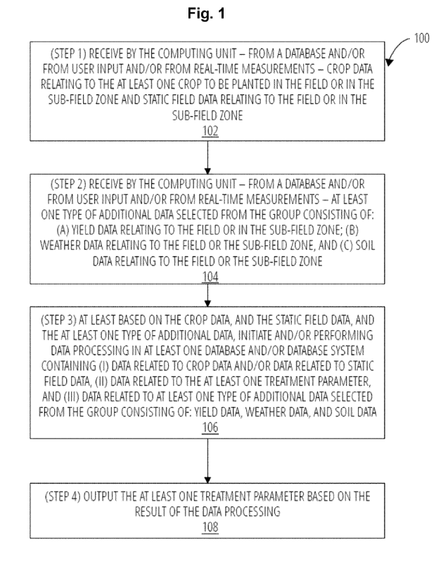
Figure 1 illustrates the workflow of the embodiment of the present invention.
In Figure 1, a computer-implemented method for determining at least one of the
treatment pa-
rameters selected from the group consisting of:
(a) at least one rate (seeding rate) for planting at least one crop in a field
or a sub-field
zone,
(b) at least one depth (seeding depth) for planting at least one crop in a
field or a sub-
field zone, and
(c) at least one time window (seeding time) for planting at least one crop in
a field or a
sub-field zone,
comprising the following steps:
(step 1) (102) receiving by the computing unit - from a database and/or from
user input
and/or from real-time measurements - crop data relating to the at least one
crop to be planted in the field or in the sub-field zone and static field data
relat-
ing to the field or the sub-field zone,
CA 03203218 2023- 6- 22
WO 2022/136182
PCT/EP2021/086610
27
(step 2) (104) receiving by the computing unit - from a database and/or from
user input
and/or from real-time measurements - at least one type of additional data se-
lected from the group consisting of:
(A) yield data relating to the field or the sub-field zone,
(B) weather data relating to the field or the sub-field zone, and
(C) soil data relating to the field or the sub-field zone,
(step 3) (106) at least based on the crop data, and the static field data, and
the at least
one type of additional data, initiating and/or performing data processing in
at
least one database and/or database system containing
(i) data related to crop data and/or data related to static field data,
(ii) data related to the at least one treatment parameter, and
(iii) data related to at least one type of additional data selected from the
group
consisting of: yield data, weather data, and soil data,
(step 4) (108) outputting the at least one treatment parameter
based on the result of
the data processing
is shown.
Figure 2
Figure 2 illustrates an embodiment of the data flow of the computer-
implemented method of the
present invention.
In a first data flow section, which corresponds to the (step 1) and (step 2)
of the computer-im-
plemented method of the present invention, data sources 101 are made
available, wherein the
data sources can be for example user device 103, database 105 and/or sensor
107. The term
"user input device" is understood to be a computer, a smartphone, a tablet, a
smartwatch, a
monitor, a data storage device, or any other device, by which a user,
including humans and ro-
bots, can input or transfer data to the field management system 112. The term
"input database"
is understood to be any organized collection of data, which can be stored and
accessed elec-
tronically from a computer system, and from which data can be inputted or
transferred to the
field management system 112. The term "sensor" is understood to be any kind of
physical or vir-
tual device, module or machine capable of detecting or receiving real-world
information and
sending this real-world information to another system, including temperature
sensor, humidity
sensor, moisture sensor, pH sensor, pressure sensor, soil sensor, crop sensor,
water sensor,
and cameras.
In a further data flow section, data which originated from one of the data
sources 101 are op-
tionally preprocessed in the data preprocessing section 110, wherein such data
preprocessing
may include data calibration, data transformation (e.g. into a different
format), data correction,
data validation, and data verification.
In a further data flow section, the data which originated from one of the data
sources 101 and
which has been optionally preprocessed in the data preprocessing section 110
are inputted into
CA 03203218 2023- 6- 22
WO 2022/136182
PCT/EP2021/086610
28
the field management system 112, for example as crop data 122, as static field
data 124, as
yield data 126, soil data 128, or as weather data 130.
In a further data flow section, which corresponds to the (step 3) of the
computer-implemented
method of the present invention, the above mentioned data are processed by the
field manage-
ment system in the data processing section 120 using for example one or more
crop-related
models 142, one or more field-related models 144, one or more yield-related
models 146, one
or more soil-related models 148, one or more weather models 150, or a
combination of such
models. Crop-related model 142 is an algorithm which is capable of
determining, predicting
and/or simulating crop species, crop phenology, crop growth, crop development
and other crop
related properties based on specific input data. Field-related model 144 is an
algorithm which is
capable of determining, predicting and/or simulating soil properties of a
field, or other field re-
lated properties based on specific input data. Yield-related model 146 is an
algorithm which is
capable of determining, predicting and/or simulating crop yield, including
crop phenology and
crop biomass based on specific input data. Agronomic recommendation model 148
is an algo-
rithm which is capable of determining one or more methods, products
(particularly seeds or
seedlings), dosages (particularly seeding rates), time windows, or other
treatment parameters
for achieving a specific real-world agronomic objective, particularly seeding,
based on specific
input data. Weather model 150 is an algorithm which is capable of determining,
predicting
and/or simulating any weather-related parameters including its development,
such as tempera-
lure, precipitation, moisture, humidity, sunshine, or wind speed. Within the
data processing sec-
tion 120, the output of one of the above mentioned model may also be directly
used as input of
another of the above mentioned models. Within the data processing section 120,
at least two,
preferably at least three of the above mentioned models may also be run either
in a parallel ar-
rangement or in a sequential arrangement or in a combination of parallel and
sequential ar-
rangement.
In a further data flow section, which corresponds to the (step 4) of the
computer-implemented
method of the present invention, the final outputs of the model(s) in the data
processing section
120 are transferred from the field management system to the data output layer
160 and for ex-
ample outputted on a user device 162, in a output database 164 or as a control
file 166. The
term "user output device" is understood to be a computer, a smartphone, a
tablet, a smartwatch,
a monitor, a data storage device, or any other device, by which a user,
including humans and
robots, can receive data from the field management system 112. The term
"output database" is
understood to be any organized collection of data, which can be stored and
accessed electroni-
cally from a computer system, and which can receive data which is outputted or
transferred
from the field management system 112. The term "control file" is understood to
be any binary
file, data, signal, identifier, code, image, or any other machine-readable or
machine-detectable
element useful for controlling a machine or device, for example an
agricultural treatment device.
Figure 3
Figure 3 schematically illustrates a treatment management system 500. The
treatment parame-
ters determined by the computer-implemented method of the present invention
will be outputted
or further processed as a control signal for an agricultural equipment
embedded in the treatment
CA 03203218 2023- 6- 22
WO 2022/136182
PCT/EP2021/086610
29
management system 500, wherein the agricultural equipment is preferably a seed
drill or
planter. The treatment management system 500 may comprise a seed drill or
planter 510, a
data management system 520, a field management system 112, and a client
computer 540.
The seed drill or planter 510 may be e.g. ground robots with variable-rate
applicators, or other
variable-rate applicators for applying seed products (particularly seeds and
seedlings) to the
field 502.
In the example of Figure 3, the seed drill or planter 510 is embodied as smart
farming machin-
ery. The smart farming machinery 510 may be a smart seed drill or smart seed
planter and in-
cludes a connectivity system 512. The connectivity system 512 may be
configured to comnnuni-
catively couple the smart farming machinery 510 to the distributed computing
environment. It
may be configured to provide data collected on the smart farming machinery 510
to the data
management system 520, the field management system 112, and/or the client
computer 540 of
the distributed computing environment.
The data management system 520 may be configured to send data to the smart
farming ma-
chinery 510 or to receive data from the smart farming machinery 510. For
instance, as detected
maps or as applied maps comprising data recorded during application on the
field 502 may be
sent from the smart farming machinery 510 to the data management system 520.
For instance,
the data management system 520 may comprise georeferenced data of different
fields and the
associated treatment map(s).
The field management system 520 may be configured to provide a control
protocol, an activa-
tion code or a decision logic to the smart farming machinery 510 or to receive
data from the
smart farming machinery 510. Such data may also be received through the data
management
system 520.
The field computer 540 may be configured to receive a user input and to
provide a field identifier
and an optional treatment specifier to the field management system 112.
Alternatively, the field
identifier may be provided by the seed drill or planter 510. Alternatively,
the optional treatment
specifier may be determined using e.g. growth stage models, weather modelling,
neighbouring
field incidences, etc. The field management system 112 may search the
corresponding agricul-
tural field and the associated treatment map(s) in the data management system
520 based on
the field identifier and the optional treatment specifier. The field computer
540 may be further
configured to receive client data from the field management system 112 and/or
the smart farm-
ing machinery 510. Such client data may include for instance application
schedule to be con-
ducted on certain fields with the smart farming machinery 510 or field
analysis data to provide
insights into the health state of certain fields.
The treatment device 510, the data management system 520, the field management
system
112, and the client computer 540 may be associated with a network. For
example, the network
may be the internet. The network may alternatively be any other type and
number of networks.
For example, the network may be implemented by several local area networks
connected to a
wide area network. The network may comprise any combination of wired networks,
wireless net-
works, wide area networks, local area networks, etc.
The data processing system of the present invention may be embodied as, or in,
or as part of
the field management system 112 to perform the above-described method to
provide a control
data to the smart farming machinery 510. For example, the field management
system 112 may
CA 03203218 2023- 6- 22
WO 2022/136182
PCT/EP2021/086610
receive the seed drill/planter configuration data from the seed drill or
planter 510 via the connec-
tivity system 512. The field management system 112 may receive geo-dependent
environmen-
tal data (e.g. temperature, moisture, humidity, and/ or wind speed) form one
or more sensors
installed on the seed drill or planter 510 to monitor environmental data.
Alternatively or addition-
5 ally, the field management system 112 may receive geo-dependent
environmental data from
weather services.
CA 03203218 2023- 6- 22