Note: Descriptions are shown in the official language in which they were submitted.
WO 2022/162563
PCT/IB2022/050691
1
VEHICLE POSITIONING SYSTEM
CROSS-REFERENCE TO RELATED APPLICATIONS
[001] This disclosure claims the priority of U.S. Provisional Application
No. 63/141,727, filed
January 26, 2021, which is incorporated herein by reference in its entirety.
BACKGROUND
[002] Positioning and speed of a rail vehicle are determined by a system
comprised of a
checked-redundant vehicle onboard controller (VOBC) operationally connected to
a set of
sensors. The sensors consist of a radio frequency identification (RFID) tag
reader, a
tachometer/speed sensor, a camera, an event camera, a LIDAR, UWB technology, a
radar,
and accelerometers, and RFID tags installed along the guideway.
[003] Systems that use unconstrained integration of inertial measurements
(e.g., a free-
space integration of inertial measurement units (IMU) or inertial sensors) in
order to perform
positioning or restrict vehicle motion along a track, guideway or path. This
restriction;
however, introduces error and/or uncertainty in the vehicle position.
BRIEF DESCRIPTION OF THE DRAWINGS
[004] Aspects of the present disclosure are best understood from the following
detailed
description when read with the accompanying FIGS. It is noted that, in
accordance with the
standard practice in the industry, various features are not drawn to scale. In
fact, the
dimensions of the various features be arbitrarily increased or reduced for
clarity of
discussion.
[005] FIG. 1 is a top-level diagram of a vehicle positioning system (VPS), in
accordance
with some embodiments.
[006] FIG. 2 is a high-level process flow diagram of an odometry-driven
positioning (ODP)
method, in accordance with some embodiments.
[007] FIG. 3 is a high-level process flow diagram of a dual chain architecture
(DCA), in
accordance with some embodiments.
[008] FIG. 4 is a high-level flow diagram of a DCA method, in accordance with
some
embodiments.
[009] FIG. 5 is a high-level functional block diagram of a processor-based
system, in
accordance with some embodiments.
CA 03204228 2023- 7-5
WO 2022/162563 PCT/IB2022/050691
2
DETAILED DESCRIPTION
[010] The following disclosure discloses many different embodiments, or
examples, for
implementing different features of the disclosed subject matter. Specific
examples of
components, values, operations, materials, arrangements, or the like, are
described below to
simplify the present disclosure. These are, of course, merely examples and are
not intended
to be limiting. Other components, values, operations, materials, arrangements,
or the like,
are contemplated. For example, the formation of a first feature over or on a
second feature
in the description that follows include embodiments in that the first and
second features are
formed in direct contact, and further include embodiments in that additional
features are
formed between the first and second features, such that the first and second
features are not
in direct contact. In addition, the present disclosure repeats reference
numerals and/or letters
in the various examples. This repetition is for the purpose of simplicity and
clarity and does
not in itself dictate a relationship between the various embodiments and/or
configurations
discussed.
[011] Further, spatially relative terms, such as beneath, below, lower,
above, upper and
the like, are used herein for ease of description to describe one element or
feature's
relationship to another element(s) or feature(s) as illustrated in the FIGS.
The spatially
relative terms are intended to encompass different orientations of the device
in use or
operation in addition to the orientation depicted in the FIGS. The apparatus
is otherwise
oriented (e.g., rotated 90 degrees or at other orientations) and the spatially
relative
descriptors used herein likewise be interpreted accordingly.
[012] In some embodiments, the term 'along-track' is used to refer to the
vehicle state
(e.g., position, velocity (speed and direction), and acceleration (change in
speed over time)).
A vehicle along-track (e.g., on a rail or guideway) or in a constrained state
(such as a vehicle
on a predetermined route) refers to a vehicle with less than nine degrees of
freedom (9D0F).
In some embodiments, the vehicle constrained state includes a vehicle along-
track position
(e.g., vehicle position), the vehicle along-track velocity (e.g., vehicle
speed and direction),
and the vehicle along-track acceleration (e.g., vehicle change in velocity
over time).
Additionally or alternatively, the vehicle constrained state is defined in
conjunction with a
three-dimensional (3D) constraining path where vehicle motion is restricted
(e.g., the vehicle
is not free to move in any direction and instead is restricted, such as along
a railway, track,
CA 03204228 2023- 7-5
WO 2022/162563 PCT/IB2022/050691
3
guideway, or predetermined route on a roadway). In some embodiments, this
state has three
degrees-of-freedom (3D0F).
10131 In some embodiments, a vehicle in an unconstrained state
(e.g., a free-space state)
refers to a nine degrees-of-freedom (9D0F) vehicle state. In some embodiments,
within the
9DOF is the 3DOF position, orientation (e.g., yaw, pitch, and roll) and the
velocity. In some
embodiments, the vehicle constrained state has 3D0F. Therefore, the v chicle
constrained
state is referenced without an associated constraining path (e.g., the
position, orientation,
and velocity are known without knowing the location or mapping of the
constrained path).
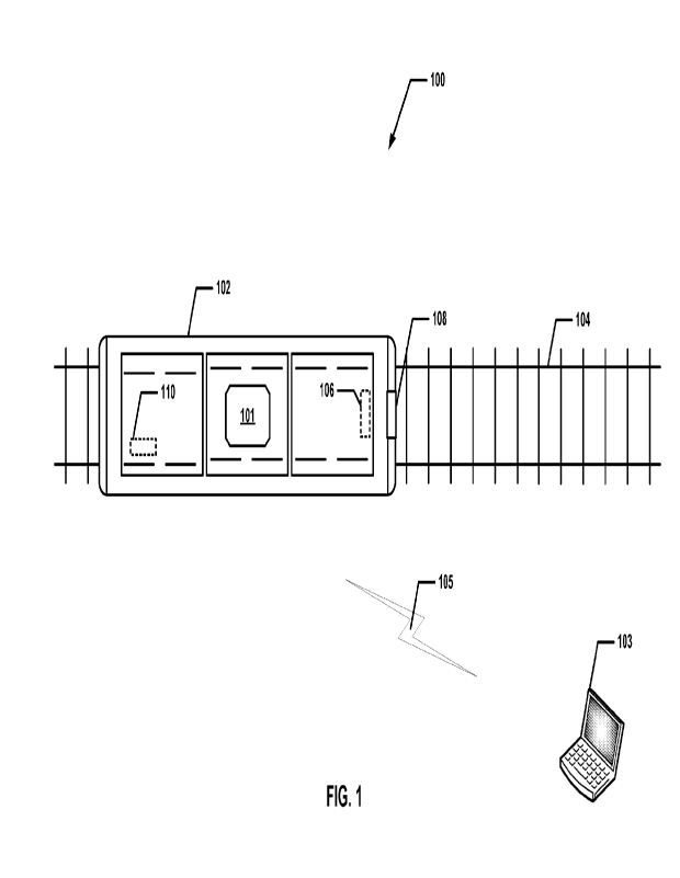
10141 FIG. 1 is a top-level diagram of a vehicle positioning
system (VPS), in accordance
with some embodiments.
10151 A vehicle positioning system (VPS) 100 includes a vehicle
102 in communication
with a CBTC 103. A wireless communication path 105 connects a vehicle onboard
controller
(VOBC) 101 and CBTC 103. Vehicle 102 is on a constrained path 104, such as a
rail or a
guideway. In some embodiments, vehicle 102 is an autonomous vehicle. In some
embodiments, vehicle 102 is another vehicle type that is configured to use a
constrained path
or constrained motion, such as a shuttle, a personal transport, a guided
vehicle, a monorail,
or an automation slide. In some embodiments, vehicle 102 is another type of
ground vehicle,
such as road vehicle (e.g., car or truck) and off-road vehicles (e.g., all-
terrain vehicles) that
have a specific/known path. Vehicle 102 includes a speed sensor 106, an
inertial
measurement unit (IMU) 108, and an optional vision or scene sensor (such as a
radar, LIDAR,
or camera) 110.
10161 VPS 100 includes VOBC 101 that is operably connected to CBTC
103 that operates
an autonomous train, such as vehicle 102 through wireless communication 105.
VPS 100,
implements a two-operation process to estimate a vehicle constrained state. A
current vehicle
constrained state is predicted (e.g., using a first subset of available sensor
measurements
providing speed data) and then the predicted vehicle constrained state is
corrected (e.g., using
a second subset of available sensor measurements providing inertial data). The
two
operations are referred to as a prediction operation and correction operation.
In some
embodiments, VPS 100 combines sensor data and processes the sensor data to
arrive at a
high-integrity estimation of the vehicle constrained state.
10171 In some embodiments, CBTC system 103 is a railway signaling
system that makes
use of telecommunications between the train (such as vehicle 102) and track
equipment for
CA 03204228 2023- 7-5
WO 2022/162563 PCT/IB2022/050691
4
traffic management and infrastructure control. CBTC system 103 is configured
to use a train
constrained state that is more accurate than traditional signaling systems.
This results in an
efficient and safe way to manage railway traffic satisfying a Safety Integrity
Level (SIL) 4.
For a system to be rated as Safety Integrity Level (SIL) 4, the system is
required to have
demonstrable on-demand reliability, and techniques and measurements to detect
and react to
failures that may compromise the system's safety properties. SIL 4 is based on
International
Electrotechnical Commission's (IEC) standard IEC 61508 and EN standards 50126
and
50129_ SIL 4 requires the probability of failure per hour to range from 10-8
to 10-9. Safety
systems that are not required to meet a safety integrity level standard are
referred to as SIL
0.
10181 In some embodiments, CBTC system 103 is a continuous,
automatic train control
system utilizing high-resolution train location determination, independent
from track
circuits, continuous, high-capacity, bidirectional train-to-wayside data
communications, and
trainborne and wayside processors capable of implementing automatic train
protection (ATP)
functions, as well as optional automatic train operation (ATO) and automatic
train
supervision (ATS) functions, as defined in the IEEE 1474 standard, herein
incorporated by
reference in its entirety.
10191 In other approaches, rail vehicle localization on a guideway
is based on inductive
loops or radio frequency identification (RFID) transponder tags.
10201 With inductive loops, a message with the loop ID is
transmitted over each loop
with a different ID per loop. When the vehicle crosses the boundary between
two adjacent
loops, the vehicle's location and direction of travel on the guideway is
initialized. Inside
each loop there are cross overs in which the phase of the transmitted signal
is flipped. The
cross overs are spread every 25m. Therefore, upon cross over detection (e.g.,
phase flip) the
vehicle's location on the guideway is updated by 25m in the direction the
vehicle is moving.
Between crossovers, a tachometer is used for dead reckoning positioning. When
the vehicle
crosses over to a new loop, the vehicle position on the guideway is re-
localized and the
direction of travel is updated.
10211 With RFID transponder tags, each tag has a unique ID which
corresponds to a
specific location on the guideway. The vehicle's position on the guideway is
initialized upon
the detection of the first tag. However, at this point the direction of travel
is still unknown.
Upon the detection of the second tag, the direction of travel is established.
Between tags, a
CA 03204228 2023- 7-5
WO 2022/162563 PCT/IB2022/050691
tachometer is used for dead reckoning position. When the next tag is detected,
the vehicle
position on the guideway is re-localized.
10221 In other CBTC approaches, a one-dimensional (1D) path
constraint is augmented
by rough grade information, and this requires frequent position updates (e.g.,
via a
transponder) to reduce positional uncertainty. This CBTC approach is not
configured to use
information about path curvature and/or grade changes to correct a vehicle
state estimate. In
contrast, embodiments of the present disclosure are configured to use odometry-
driven
positioning that is configured to use a 3D path constraint so information
about grade changes
and/or track curvature is usable to correct the vehicle state estimate.
[023] In other CBTC approaches, a vehicle state correction based on path
constraint is
not performed. Thus, the output is an estimate of the worst-case positional
uncertainty based
strictly on uncertainty of displacement integration. Thus, uncertainty
increases rapidly,
requiring frequent positional updates (e.g., via transponders or loops) to
remove accumulated
positional uncertainty, even when high-performance sensors are used to
estimate position
(e.g., tachometers). In contrast, embodiments of the present disclosure allow
for longer
vehicle running times before positional uncertainty occurs. Longer vehicle
running times
leads to higher system availability, less installation effort during the
system deployment
phase (e.g., as less landmarks need to be installed) and lower life cycle cost
(e.g., as less
effort is needed to maintain the landmarks).
[024] In other CBTC approaches, a tachometer is used for positioning and
the CBTC
does not make use of additional information available in geometry of a path
constraint.
Further, other CBTC approaches are able to dead-reckon for hundreds of meters
or hundreds
of seconds before a measurement from another landmark or speed sensor is
required.
Otherwise, positional uncertainty will exceed a threshold (e.g., ¨20m). The
dead-reckoning
performance affects the necessary spacing of landmarks, since exceeding the
positional error
threshold causes the system to become unavailable. In contrast, embodiments of
the present
disclosure are configured for improved accuracy and dead-reckoning
performance.
[025] In some embodiments, vehicle 102 is a machine that transports people
and/or
cargo. In some embodiments, vehicle 102 includes wagons, bicycles, motor
vehicles
(motorcycles, cars, trucks, and buses), railed vehicles (trains, trams),
watercraft (ships,
boats), amphibious vehicles (screw-propelled vehicle, hovercraft), aircraft
(airplanes,
helicopters) and spacecraft. Land vehicles are classified broadly by what is
used to apply
CA 03204228 2023- 7-5
WO 2022/162563 PCT/IB2022/050691
6
steering and drive forces against the ground: wheeled, tracked, railed or
skied, such as is
detailed in ISO 3833-1977 standard. Vehicle 102 is restricted to a constrained
path, such as
constrained path 104. In some embodiments, vehicle 102 is an autonomous
vehicle.
Autonomous vehicles use mechatronics, artificial intelligence, and/or multi-
agent systems to
assist a vehicle's operator.
10261 Constrained path 104 is a track on a railway or railroad,
further known as a
permanent way (e.g., a constrained path). Constrained path 104 is the
structure consisting of
the rails, fasteners, railroad ties and ballast (or slab track), plus the
underlying subgrade. The
constrained path enables trains to move by providing a dependable surface for
their wheels
to roll upon. For clarity, constrained paths are referred to as railway
tracks, railroad track or
a guideway. However, constrained paths are not restricted to railways and in
some
embodiments, constrained paths further include any autonomous vehicle that is
limited to a
predetermined or preprogramed route (e.g., self-driving car or truck moving
along an
inputted or predetermined route).
10271 In some embodiments, speed sensor 106 is a sensor used to
detect the speed of
vehicle 102 along constrained path 104. In some embodiments, speed sensor 106
is a wheel
speed sensor (e.g., a tachometer), a speedometer, a LIDAR, a ground speed
radar, a Doppler
radar, or a laser surface velocimeter. In some embodiments, speed sensor 106
senses the rate
of change of a vehicle's position with respect to a frame of reference and a
difference of
time. Velocity is a physical vector quantity that includes both magnitude and
direction. If
there is a change in speed, then the object has a changing velocity vector and
is said to be
undergoing an acceleration/deceleration.
10281 In some embodiments, IMU 108 is an electronic device that
measures and reports
a body's specific force, angular rate, and sometimes the orientation of the
body, using a
combination of accelerometers and gyroscopes. In some embodiments, IMU 108
includes
one or more magnetometers.
10291 In some embodiments, vision sensor 110 is a radar, a LIDAR
or a camera used for
determining landmark measurements. In some embodiments, CBTC 103 or VOBC 101
are
configured with a database storing a known position of many landmarks along a
path
constraint. A vision sensor 110 determines a distance and bearing to a
landmark having a
known position and then determines a position of vehicle 102. In some
embodiments, this
CA 03204228 2023- 7-5
WO 2022/162563
PCT/IB2022/050691
7
bearing and distance to the known landmark is used by CBTC 103 or VOBC 101 to
calculate
a position of the vehicle.
10301 In some embodiments, a system including one or more
computers are configured
to perform particular operations or actions by virtue of having software,
firmware, hardware,
or a combination of them installed on the system that in operation causes or
cause the system
to perform the actions. One or more computer programs are configured to
perform particular
operations or actions by virtue of including instructions that, when executed
by data
processing circuitry, cause the apparatus to perform the actions. In some
embodiments, VPS
100 includes processing circuitry, e.g., processing circuitry 502 (FIG. 5),
and a memory, e.g.,
memory 504 (FIG. 5), connected to the processing circuitry, where the memory
is configured
to store executable instructions, e.g., executable instructions 506 (FIG. 5),
such as methods
200, 300, and 400, of FIGS. 2, 3, and 4. When executed by processing circuitry
502,
executable instructions 506 facilitate performance of operations that include:
receiving
vehicle speed data from a first set of sensors 106 operably coupled to a
vehicle 102;
predicting a vehicle location based on the vehicle-speed data; receiving
inertial data from a
second set of sensors 108 operably coupled to vehicle 102; and updating the
predicted vehicle
location based upon the inertial data.
10311 FIG. 2 is a high-level process flow diagram of an odometry-
driven positioning
(ODP) method 200, in accordance with some embodiments.
10321 In some embodiments, ODP method 200 is a subsystem of VPS
100 and is
implemented to determine a constrained vehicle state for vehicle 102. ODP
method 200 is
configured to accurately predict positioning, motion, and velocity of a
vehicle in a
constrained state. In some embodiments, ODP method 200 is used to determine
vehicle
positioning for vehicle 102 of VPS 100_ The sequence in which the operations
of ODP
method 200 are depicted in FIG. 2 is for illustration only; the operations of
ODP method 200
are capable of being executed in sequences that differ from that depicted in
FIG. 2. In some
embodiments, operations in addition to those depicted in FIG. 2 are performed
before,
between, during, and/or after the operations depicted in FIG. 2.
10331 In some embodiments, one or more of the operations of ODP
method 200 are a
subset of operations of a method of determining vehicle position. In various
embodiments,
one or more of the operations of ODP method 200 are performed by using one or
more
processors, e.g., a processing circuitry 502 discussed below with respect to
positioning
CA 03204228 2023- 7-5
WO 2022/162563 PCT/IB2022/050691
8
processing circuitry 502 and FIG. 5. In some embodiments, ODP method 200 is
executed on
VOBC 101 and/or CBTC 103.
10341 In some embodiments, an architecture and sensor data
collection methods are
combined and process sensor data to arrive at a high-integrity estimation of a
vehicle
constrained state. ODP method 200 is a VPS method to localize a vehicle, such
as vehicle
102, a guided shuttle, monorail, or personal transport that is operating on a
constrained path,
such as track 104. In some embodiments, ODP method 200 provides an estimate of
the
vehicle constrained state. In some embodiments, ODP method 200 obtains data
from specific
sensors and determines a position, speed and acceleration estimate based on a
prediction
operation for the vehicle.
10351 In some embodiments, operation 202 of ODP method 200,
obtains vehicle ground
speed (e.g., a speed measurement) from a ground speed sensor (e.g.,
tachometer) or vehicle
speed is obtained (e.g., after processing) from a vision or scene sensor 110
(e.g., radar,
camera, or the like). In some embodiments, all speed measurements are subject
to an expected
uncertainty and referred to as speed measurement uncertainty. Speed
measurement
uncertainty is accounted for in correction operation 206. Correction operation
206 is based
on the measurements and the measurements variability/distribution which
represents the
measurement error/uncertainty. Uncertainty is accounted for through accounting
for the
causes of the speed measurement uncertainty (e.g., bias error, scaling error,
sampling
limitations, and the like. Uncertainty is due to limitations of the sensing
technology,
installation error, limitations of the estimation algorithms, and the like.
10361 ODP method 200 moves from ground speed operation 202 to
prediction operation
204 where a positioning prediction is formulated as a motion/process model
that integrates
the vehicle speed measurements received. In some embodiments, prediction
operation 204 is
implemented with an extended Kalman filter (EKF) (in estimation theory EKF is
the
nonlinear version of the Kalman filter that linearizes about an estimate of
the current mean
and covariance), batch estimation (based on a maximum a posteriori estimation
approach
where the time history of the input and output measurements are used as a
single batch of
data for estimating the finite element model parameters), or sliding window
Bayesian
framework (Bayesian networks are for taking an event that occurred and
predicting the
likelihood that any one of several possible known causes was the contributing
factor).
Positioning operation 204 isolates the path constraint (e.g., removes the path
constraint from
CA 03204228 2023- 7-5
WO 2022/162563 PCT/IB2022/050691
9
the prediction operation 204) and eliminates some inertial measurements (e.g.,
measurements
such as the vehicle body bouncing) until correction operation 206. An output
of prediction
operation 204 is a predicted vehicle state, along a path constraint (e.g.,
track 104) using
odometry (e.g., ground speed from sensors 106 and/or 110).
10371 The process flow of ODP method 200 proceeds from prediction
operation 204 to
correction operation 206. In some embodiments, correction operation 206 is a
measurement/observation model that uses a Kalman framework (a Kalman filter is
an
algorithm that uses a series of measurements observed over time, containing
statistical noise
and other inaccuracies, and produces estimates of unknown variables that tend
to be more
accurate than those based on a single measurement alone to update the
predicted vehicle
state). Additionally or alternatively, either a recursive (further known as a
Bayes filter, a
general probabilistic approach for estimating an unknown probability density
function
recursively over time using incoming measurements and a mathematical process
model), a
batch, or a sliding window implementation is used to allow more time-
operations in the
processing (e.g., leverage the track geometry information).
10381 At operation 206, the predicted vehicle state is corrected
using vehicle body
inertial measurements 208 (e.g., accelerations and gyroscopic rates, inertial
measurements).
In some embodiments, the vehicle body inertial measurements 208 are provided
directly by
an inertial measurement device, such as IMU 108.
10391 Additionally or alternatively, correction operation 206 is
configured to use
landmark measurements 210, determined from vision or scene sensor 110 (e.g.,
radar,
camera, or the like). In some embodiments, correction operation 206 is
configured to use
ultra-wideband (UWB) radio or other landmark/anchor technology when the
vehicle is within
a region of localization (e.g., the region around a IJWB anchor, or the region
in which a
global navigation satellite system (GNSS) signal is available), but where
successive regions
of localization are separated by significant distances.
10401 In some embodiments, correction operation 206 is configured
to use other optional
measurements 212, such as radio frequency identification (RFID) tags located
along track
104. In some embodiments, each of the inertial 208, landmark 210 and/or other
measurements
212 are subject to an expected and characterizable uncertainty herein referred
to as inertial
measurement uncertainty. The inertial measurement uncertainty is due to
vehicle body
inertial measurements 208 that contain contributions from both the bogie
kinematics and
CA 03204228 2023- 7-5
WO 2022/162563
PCT/IB2022/050691
resulting dynamics, as well as the vehicle body dynamics due to the bogie-body
suspension.
Thus, inertial measurements 208 contain both inertial forces due to the
vehicle motion and
the inertial forces due to the vehicle vibrations and suspended/sprung mass of
the vehicle
body. The vehicle vibrations and suspended/sprung mass of the vehicle body
create the
inertial measurement uncertainty. Inertial measurement uncertainty is dealt
with in
correction operation 206. In correction operation 206 a prediction from
prediction operation
204 and the prediction uncertainty are compared against the inertial
measurement and the
inertial measurement uncertainty to determine whether the comparisons match or
not and
what level of trust or weight should be given to the prediction and inertial
measurement. In
some embodiments, machine learning or artificial intelligence are configured
to determine
the weight assigned to the prediction and to the inertial measurement. The
inertial
measurement uncertainty is the result of bias, scaling factors, installation
error, sampling
limitations, and the like. In some embodiments, ODP method 200 is based on
along track
positioning, speed, and the associated uncertainties. In some embodiments,
positioning and
speed accuracies are affected by the quality and trust level in the along
track position and
speed uncertainties. In some embodiments, the uncertainty ranges from 5cm to
10m. This is
an improvement over other approaches where the range of uncertainty is between
5m to 25m.
The uncertainty is resolved in correction operation 206 where the predicted
position is
compared with dead reckoning position from inertial measurements 208, landmark
measurements 210, and/or path constraint information that include inertial
landmarks 214.
In some embodiments, when the difference between the predicted location and
the dead
reckoning position of inertial measurements, landmark measurements, and/or
inertial
measurements are within the current uncertainty range, then a position
correction is made at
operation 206.
10411 In some embodiments, correction operation 206 receives from
database 214 a
parametrization of the three-dimensional (3D) vehicle path, such as track 104,
along which
the vehicle is constrained. In some embodiments, the vehicle path is in the
form of a
parametrized curve, such that, at any point along the path constraint, it is
possible to predict
the expected inertial measurements when the vehicle position, velocity, and
acceleration are
known.
10421 In some embodiments, the path constraint further contains
one or more regions
along the path during transit of which the vehicle experiences specific and
characterizable
CA 03204228 2023- 7-5
WO 2022/162563
PCT/IB2022/050691
11
inertial behavior (e.g., inertial landmarks). In some embodiments, switches,
level crossings,
speed bumps, road, or bridge transitions, or the like create inertial
landmarks (e.g., the
inertial forces due to the vehicle vibrations and suspended/sprung mass of the
vehicle body).
Additionally or alternatively, with inertial landmarks the inertial behavior
of the vehicle is
characterized. In some embodiments, the expected uncertainty in the inertial
behavior,
referred to as landmark inertial uncertainty, as well as the uncertainty in
the placement of
the landmark, referred to as landmark location uncertainty, is known. In some
embodiments,
inertial landmarks determine an acceleration (e.g., specific force) and
angular rate signature
for a specific geographical location. In some embodiments, inertial landmarks
assist in
correction operation 206 to correct inaccuracies in speed. In some
embodiments, landmark
range uncertainty ranges are between 10cm to lm.
10431 In some embodiments, correction operation 206 is configured
to receive from
database 214 path constraint information, precomputed observations, inertial
landmarks, as
well as other landmark information. ODP method 200 is configured to use
inertial
measurements 208 that are partially precomputed given a known path constraint
during
correction operation 206. Additionally or alternatively, this precomputation
allows the
vehicle state (position) to be corrected during correction operation 206 based
on the geometry
of the path constraint. In some embodiments, ODP method 200 reduces data
dropout through
correction operation 206 that is configured to increase position availability.
Further,
precomputed inertial observations along the path constraint stored in database
214 minimize
the processing load during correction operation 206. In some embodiments,
inertial
landmarks are embedded in the precomputed information and stored in database
214. In this
way, expected inertial observations (e.g., accelerations, gyroscopic rates,
gravitational
vector components, etc.) are precomputed at each location and parameterized
according to
the vehicle speed, along the path constraint. ODP method 200 reduces or is
less susceptible
to data dropout. Other approaches configured with IMU inputs to prediction
operation 204
encounter periods of time where speed data is dropped; hence, the term data
dropout. Data
dropout occurs when a vehicle is moving slower than an IMU is able to detect
or other
situations where speed inputs to prediction operation are lost.
10441 Correction operation 206 outputs a final vehicle state. The
final vehicle state is
inputted into single-chain fault detection and isolation operation 216. In
some embodiments,
an algorithm or method is used to achieve fault detection and isolation (FDI).
In some
CA 03204228 2023- 7-5
WO 2022/162563
PCT/IB2022/050691
12
embodiments, the fault detection and isolation is configured to use a receiver
autonomous
integrity monitoring (RAIM) like probabilistic model (that detects faults with
redundant
measurements), or a heuristic based (strategies derived from previous
experiences with
similar problems), or a probabilistic graphical model (a probabilistic model
for which a graph
expresses the conditional dependence structure between random variables), or a
neural
network (artificial networks used for predictive modeling, adaptive control
and applications
where they are trained via a dataset), or the like. In some embodiments, each
input has an
expected error and a fault condition that is derived. In some embodiments,
these faults are
detected and isolated in operation 216. In some embodiments, a recursive
filter
implementation is used. The error and fault condition are an inconsistency
between the
prediction and the inertial measurement. The error and fault condition is
derived by
determining whether the inconsistency is attributed to the prediction or the
inertial
measurement. Once determined, the fault is isolated to the prediction (e.g.,
odometry) or the
measurement (e.g., inertial navigation).
10451 ODP method 200 estimates a vehicle state that uses a 2-
operation approach (i.e.,
prediction operation 204 and correction operation 206), where the prediction
operation 204
is performed using ground speed. In some embodiments, correction operation 206
is
performed using inertial measurements in comparison with a path constraint. In
some
embodiments, ODP method 200 further uses inertial landmarks (although other
landmarks
and measurements are optionally used) in addition to the inertial
measurements.
10461 ODP method 200 determines a vehicle state with minimal or
nonexistent wayside,
trackbed or path-installed infrastructure dedicated for positioning. In some
embodiments,
inertial landmarks are part of the existing trackbed, or path and no
additional equipment is
needed (leading to no installation cost). In some embodiments, when other
landmarks are
used (e.g., UWB, tags) then the spacing is increased to minimize the total
number of installed
landmarks (leading to a reduction of installation cost).
10471 In some embodiments, ODP method 200 supports diversity in
the vehicle state
estimation technologies. In some embodiments, both speed and inertial
measurement devices
are used. In some embodiments, ODP method 200 provides a more complete use of
the
geometry of the path constraint, providing higher accuracy in determining the
vehicle state.
In some embodiments, ODP method 200 uses the geometry of the path constraint
to correct
the vehicle state. In some embodiments, ODP method 200 supports batch or
sliding window
CA 03204228 2023- 7-5
WO 2022/162563
PCT/IB2022/050691
13
implementations whereby the full geometry of the path constraint is used,
rather than the
local geometry around the current vehicle state.
10481 In some embodiments, a high integrity solution is obtained when compared
to
existing FDI approaches. In some embodiments, ODP method 200 provides a more
transparent and direct uncertainty estimation that allows for specific faults
to be identified,
particularly in relation to the geometry of the path constraint. In some
embodiments, using
ground speed in prediction operation 204 and not using less-trusted inputs
(e.g., IMU,
landmarks, and path constraint) in the correction operation 206 allows for
more effective
FDI. The uncertainties (positional, speed measurement, inertial measurement,
and landmark
inertial) are minimized in the early stages of ODP method 200. In other
approaches, where
an IMU is used for the ground speed input to the prediction operation 204, the
position error
is non-linear (e.g., squared) with respect to time (t2). In other approaches,
the more time a
system relies on dead reckoning the larger the error. In some embodiments,
when using
odometry measurements, in contrast to IMU based speed measurements, the
position error
grows linearly with time. Thus, reducing error growth over time.
10491 In some embodiments, ODP method 200 provides for a more
efficient prediction
operation 204 and correction operation 206 and higher performance and
availability than
other approaches. In some embodiments, ODP method 200 allows longer running
times
before positional uncertainty is breached which leads to higher availability
than other
methods. In some embodiments, ODP method 200 allows for longer running times
without
correction operation 206 which leads to increased availability over other
methods.
10501 In some embodiments, ODP method 200 provides for lower
installation and
maintenance costs compared to other approaches. In some embodiments, ODP
method 200
achieves improved performance with fewer wayside, trackbed or path-installed
landmarks,
resulting in lower installation cost and maintenance cost compared to other
approaches.
10511 In some embodiments, ODP method 200 is configured to use an
along-track
acceleration input to prediction operation 204 (along with odometry). Along-
track
acceleration does not contain track geometry information. Instead, along-track
acceleration
provides an accurate along-track estimate of position when combined with along-
track speed
from odometry.
10521 In some embodiments, inertial measurements 208 are used in
prediction operation
204 along with odometry measurements 202. While the along-track acceleration
from the
CA 03204228 2023- 7-5
WO 2022/162563
PCT/IB2022/050691
14
inertial measurements 208 contains no information of track geometry, the along-
track
acceleration from the inertial measurements 208 produces an accurate along-
track estimate
of position when combined with odometry measurements 202. In some embodiments,
along-
track acceleration in combination with odometry measurements 202 is a better
estimate of
along-track speed. In some embodiments, X-axis, Y-axis, and Z-axis
acceleration are used
to derive along-track acceleration, and X-axis gyroscope measurements are used
to estimate
vehicle roll and pitch and produce a contribution of X-axis, Y-axis, and Z-
axis acceleration
components In some embodiments, an X-axis gyroscope output is fed into
prediction to
estimate roll and pitch states. The roll state is a coupling of gravity with
lateral acceleration
(e.g., tangential acceleration is composed of both x and y components due to
misalignment
between the bogie and vehicle body frame). In some embodiments, roll state
estimation
determines a contribution of X-axis and Y-axis components, thus producing an
accurate
tangential acceleration. In some embodiments, the roll state estimation is
configured to be
performed with X-axis and Y-axis gyroscopes.
10531 In some embodiments, ground speed is determined via the
processing of a subset
of inertial measurements 208 instead of a ground speed measurement sensor. In
some
embodiments, inertial measurements 208 or a subset of inertial measurements
208 produce
effective ground speed measurements including tangential speed.
10541 In some embodiments, ODP method 200 uses both speed and
inertial measurement
devices for prediction operation 204. In some embodiments, path constraint
information from
database 214 supply the geometry of the path constraint. In some embodiments,
ODP method
200 is configured to use the path constraint geometry to correct the predicted
vehicle state.
Additionally or alternatively, ODP method 200 supports batch or sliding window
implementations where the full geometry of the path constraint is used, rather
than the local
geometry around the current vehicle state. In some embodiments, the path
constraint is
correcting the predicted vehicle state
10551 In some embodiments, ODP method 200, is more accurate when
compared to other
FDI approaches. In some embodiments, uncertainty estimation allows for
specific faults
(e.g., speed measurement uncertainty and inertial measurement uncertainty) to
be identified,
particularly in relation to the geometry of the path constraint. In some
embodiments, the use
of ground speed (e.g., trusted and characterized) in the prediction operation,
and less-trusted
CA 03204228 2023- 7-5
WO 2022/162563
PCT/IB2022/050691
inputs (e.g., IMU, landmarks, path constraint) in the correction operation
allow for effective
FDI.
10561 In some embodiments, ODP method 200 provides higher
performance and
availability when compared with other CBTC approaches. Additionally or
alternatively, ODP
method 200 allows for longer running times before positional uncertainty is
breached,
leading to availability of an accurate vehicle position. In some embodiments,
ODP method
200 allows for increased running times without correction operation 206.
[057] FIG. 3 is a high-level process flow diagram of a dual chain
architecture (DCA)
method 300, in accordance with some embodiments.
[058] In some embodiments, DCA method 300 is a subsystem of VPS 100 like
ODP
method 200 and is used on vehicle 102 to accurately predict positioning,
motion, and
velocity. In some embodiments, DCA method 300 is used to determine vehicle
positioning
for vehicle 102 of VPS 100. The sequence in which the operations of DCA method
300 occur
are like the operations of ODP method 200 depicted in FIG. 2 and similar
operations retain
the same reference numbers for the sake of brevity and is for illustration
only. The operations
of DCA method 300 are capable of being executed in sequences that differ from
that depicted
in FIG. 3. In some embodiments, operations in addition to those depicted in
FIG. 3 are
performed before, between, during, and/or after the operations depicted in
FIG. 3.
10591 In some embodiments, one or more of the operations of DCA
method 300 are a
subset of operations of a method of determining vehicle position. In various
embodiments,
one or more of the operations of DCA method 300 are performed by using one or
more
processors, e.g., a processing circuitry 502 discussed below with respect to
positioning
processing circuitry 502 (FIG. 5). In some embodiments, DCA method 300 is
executed on
VOBC 101 and/or CBTC 103_
[060] DCA method 300 combines dual complementary processing chains
(e.g., ODP 200
and IMU driven positioning (IMUDP) 350) that each compute the vehicle
constrained state,
in such a way that diverse supervision and cross-checking is possible
throughout the entire
processing chain.
10611 Operation 302 of DCA method 300, receives inertial
measurements from an IMU,
such as IMU 108. In some embodiments, method 300 progresses to operation 304
where a
prediction operation is performed using path constraint information from
database 214.
Additionally or alternatively, when using unconstrained integration of
inertial measurements
CA 03204228 2023- 7-5
WO 2022/162563
PCT/IB2022/050691
16
(e.g., a free-space integration of inertial measurement units (IMU) or
inertial sensors) in
order to perform positioning, a vehicle is restricted along a track. Thus, the
path constraint
information is used at predication operation 304. This restriction; however,
introduces error
and/or uncertainty in the vehicle position.
10621 DCA method 300 progresses to prediction operation diverse
cross-check 305
where a vehicle predicted state from prediction operation 204 and prediction
operation 304
are compared. DCA method 300 determines which of the vehicle predicted states,
either the
vehicle predicted state of prediction operation 204 or prediction operation
304 is more
accurate. In some embodiments, based on the accuracy determination, DCA method
300 will
use the more accurate of the predicted vehicle state from either ODP method
200 or IMUDP
350. In some embodiments, a position is determined using odometry prediction
and IMU
correction at correction operation 206. In some embodiments, position is
determined using
IMU prediction and odometry correction at correction 306. In some embodiments,
the
position of correction operation 206 is compared with the position of
correction operation
306 and an accuracy is determined based upon the comparison.
10631 ODP method 300 moves from prediction operation 304, to
correction operation
306. Correction operation 306 is a measurement/observation model that uses a
Kalman
framework to update the predicted vehicle state. Additionally or
alternatively, either a
recursive, a batch, or a sliding window implementation is used to allow more
time-operations
in the processing.
10641 At correction operation 306 the vehicle state corrected
using vehicle odometry
measurements 308 (e.g., ground speed). In some embodiments, the vehicle ground
speed
measurements 308 are supplied directly by a ground speed device (e.g., speed
sensor 106).
10651 In some embodiments, correction operation 306 is configured
to use landmark
measurements 310, determined from vision or scene sensor 110 (e.g., radar,
camera, or the
like). In some embodiments, correction operation 306 is configured to use of
ultra-wideband
(UWB) radio or other landmark/anchor technology when the vehicle is within a
region of
localization (e.g., the region around a UWB anchor, or the region in which a
global
navigation satellite system (GNSS) signal is available), but where successive
regions of
localization are separated by significant distances.
10661 In some embodiments, correction operation 306 is configured
to use other optional
measurements 312, such as radio frequency identification (RFID) tags located
along track
CA 03204228 2023- 7-5
WO 2022/162563
PCT/IB2022/050691
17
104. In some embodiments, each of the ground speed 308, landmark 310 and/or
other
measurements 312 are subject to an expected and characterizable uncertainty
referred to
above as speed measurement uncertainty.
10671 In some embodiments, correction operation 306 receives from
database 214 a
parametrization of the three-dimensional (3D) vehicle path, such as track 104,
along which
the vehicle is constrained. In some embodiments, the vehicle path is in the
form of a
parametrized curve, such that, at any point along the path constraint, it is
possible to predict
the expected inertial measurements when the vehicle position, velocity, and
acceleration are
known.
[068] In some embodiments, the path constraint further contains
one or more regions
along the path during transit of which the vehicle experiences specific and
characterizable
inertial behavior (e.g., inertial landmarks). In some embodiments, switches,
level crossings,
speed bumps, road, or bridge transitions, or the like create inertial
landmarks (e.g., the
inertial forces due to the vehicle vibrations and suspended/sprung mass of the
vehicle body).
Additionally or alternatively, with inertial landmarks the inertial behavior
of the vehicle is
characterized. In some embodiments, the expected uncertainty in the inertial
behavior,
referred to as landmark inertial uncertainty, as well as the uncertainty in
the placement of
the landmark, referred to as landmark location uncertainty, is known.
10691 In some embodiments, correction operation 306 is configured
to receive from
database 214 path constraint information, precomputed observations, inertial
landmarks, as
well as other landmark information. DCA method 300 is configured to use ground
speed
measurements 308 during correction operation 306In some embodiments, DCA
method 300
reduces data dropout through correction operation 306, that is configured to
increase position
availability. In some embodiments, precomputed inertial observations along the
path
constraint stored in database 214 minimize the processing load during
correction operation
306. In some embodiments, inertial landmarks are embedded in the precomputed
information
and stored in database 214. In this way, expected inertial observations (e.g.,
accelerations,
gyroscopic rates, gravitational vector components, etc.) are precomputed at
each location
and parameterized according to the vehicle speed, along the path constraint.
[070] Correction operation 306 outputs a final vehicle state.
Final vehicle states from
correction operation 206 and correction operation 306 are compared at
correction operation
divers cross check operation 307_ In some embodiments, like the operation at
prediction
CA 03204228 2023- 7-5
WO 2022/162563
PCT/IB2022/050691
18
operation diverse cross-check 305, DCA method 300 determines which final
vehicle state is
most accurate. Additionally or alternatively, based on the determination of
which final
vehicle state is more reliable, DCA method 300 will use either ODP method 200
or IMUDP
method 350. In some embodiments, DCA method 300 is configured to use a
statistical based
filter, such as a Kalman filter, to determine a state update (i.e.,
correction). In some
embodiments, the state update is typically made using multiple measurements.
In some
embodiments, each measurement has an average (p) and standard deviation (a).
In a non-
limiting example, assuming that all measurements are identical (pl = =
= Ian) and the
standard deviation of all measurements are identical (al = a2 =
= an). Then the output
is p.= (ti + 112 + + pn) / n = = = !An, and 6 = ((a12 + a22 +
61/n1/2 = a2/n1/2 = = an/n1/2 < a 1 = a2 = = an.
10711
Fault detection and isolation is performed by method 350 at operation
316. In some
embodiments, DCA method 300 performs diversity checking at prediction
operations cross-
check 305 and correction operations cross-check 307. Additionally or
alternatively, dual-
chain FDI operation 316 models simultaneous faults in both chains (ODP method
200 and
IMUDP 350).
10721
In some embodiments, DCA method 300 provides algorithmic and sensor
diversity. Additionally or alternatively, dual chains (e.g., ODP 200 and IMUDP
350) are
complementary of each other in that each calculates positioning information,
but with
different sensors (e.g., a ground sensor for ODP 200 and an IMU for IMUDP
350), and in
parallel operations (i.e., prediction operations 204 & 304 and correction
operations 206 &
306).
10731
FIG. 4 is a high-level flow diagram of a DCA method 400, in
accordance with
some embodiments.
10741
In some embodiments, DCA method 400 is a subsystem of VPS 100 like
ODP
method 200 and DCA method 300 and is used on vehicle 102 to accurately predict
positioning, motion, and velocity. In some embodiments, DCA method 400 is used
to
determine vehicle positioning for vehicle 102 of VPS 100. The sequence in
which the
operations of DCA method 400 occur are like the operations of ODP method 200
and DCA
method 300 depicted in FIGS. 2 and 3 and is for illustration only. The
operations of DCA
method 400 are capable of being executed in sequences that differ from that
depicted in FIG.
CA 03204228 2023- 7-5
WO 2022/162563
PCT/IB2022/050691
19
4. In some embodiments, operations in addition to those depicted in FIG. 4 are
performed
before, between, during, and/or after the operations depicted in FIG. 4.
10751 In some embodiments, one or more of the operations of DCA
method 400 are a
subset of operations of a method of determining vehicle position. In various
embodiments,
one or more of the operations of DCA method 400 are performed by using one or
more
processors, e.g., a processing circuitry 502 discussed below with respect to
positioning
processing circuitry 502 (FIG. 5). In some embodiments, DCA method 400 is
executed on
VOBC 101 and/or CBTC 103_
10761 FIG. 4 includes processing blocks 402, 404, 406, 408, 410,
412, 414, 416 and 418.
At block 402, vehicle speed or odometry data is received. As a non-limiting
example, in the
embodiments as shown in FIGS. 1, 2, and 3, ground speed is obtained from a
ground speed
sensor, such as speed sensor 106 at operation 202. From block 402, the flow
proceeds to
block 404.
[077] At block 404, vehicle inertial data is received. As a non-limiting
example, in the
embodiments as shown in FIGS. 1, 2, and 3 inertial measurements are obtained
from a sensor, such as
MIT 1 1 0 at operation 208 and 302. From block 404, the flow proceeds to block
406.
[078] At block 406, a first constrained vehicle state is predicted. As a
non-limiting example, in
the embodiments as shown in FIGS. 1, 2, and 3 processor 502 determines a first
predicted constrained
vehicle state at operation 206. From block 406, the flow proceeds to block
408.
[079] At block 408, a second constrained vehicle state is predicted. As a
non-limiting example,
in the embodiments as shown in FIG. 3 processor 502 determines a second
predicted constrained
vehicle state at operation 306. From block 408, the flow proceeds to block
410.
[080] At block 410, the first and second predicted constrained vehicle
states are cross-checked.
As a non-limiting example, in the embodiments as shown in FIG. 3 processor 502
determines whether
one predicted vehicle state is more reliable than the other at operation 305.
From block 410, the flow
proceeds to block 412. Before determining the accuracy processor 502
determines what state (e.g.,
predicted or measured) is more reliable or trusted. The answer to this
question will determine the
weight (e.g., trust) assigned to each in order to produce a state update based
on the prediction and
measurements. The accuracy is secondary and is resolved by the statistical
nature of the filter.
[081] At block 412, the first predicted constrained vehicle state is
corrected based upon data other
than ground speed. In some embodiments, a correction is not performed as the
first predicted vehicle
state is accurate. As a non-limiting example, in the embodiments as shown in
FIGS. 1, 2, and 3 inertial
CA 03204228 2023- 7-5
WO 2022/162563
PCT/IB2022/050691
data, inertial landmarks, path constraint information, visual landmarks and
other data is used to create
a corrected constrained vehicle operation 206. From block 412, the flow
proceeds to block 414.
[082] At block 414, the second predicted constrained vehicle state is
corrected. In some
embodiments, a correction is not performed as the second predicted vehicle
state is accurate. As a non-
limiting example, in the embodiments as shown in FIG. 3 ground speed data,
inertial landmarks, path
constraint information, visual landmarks and other data is used to create a
corrected constrained
vehicle operation 306. From block 414, the flow proceeds to block 416.
[083] At block 416, the first and second corrected constrained vehicle
states are cross-checked.
As a non-limiting example, in the embodiments as shown in FIG. 3 processor 502
determines whether
one corrected vehicle state is more reliable than the other at operation 307.
From block 416, the flow
proceeds to block 418.
[084] At block 418, after a determination as to the first and second
corrected vehicle states, a
final vehicle position state is determined. In a non-limiting example, a fault-
corrected vehicle state is
determined as shown in FIG. 2 or a consolidated vehicle state is determined as
shown in FIG. 3. In
some embodiments, the fault-corrected vehicle state or consolidated vehicle
state is outputted to a user
interface, such as user interface 542 (FIG. 5) In some embodiments, the fault-
corrected vehicle state
or consolidated vehicle state is outputted to CBTC 103 (FIG. 1). In some
embodiments, in the event
the first and second corrected vehicle states do not cross-check correctly a
dead-reckoning solution is
used until the next the fault-corrected vehicle state or consolidated vehicle
state is determined.
[085] FIG. 5 is a high-level functional block diagram of a processor-based
system, in
accordance with some embodiments. In some embodiments, positioning processing
circuitry
500 is a general-purpose computing device including a hardware processor 502
and a non-
transitory, computer-readable storage medium 504. In some embodiments,
positioning
processing circuity 500 is VOBC 101 and/or CBTC 103. Storage medium 504,
amongst other
things, is encoded with, i.e., stores, computer program instructions 506,
i.e., a set of
executable instructions such as ODP method 200, and/or DCA methods 300 and 400
of FIGS.
2, 3, and 4. Execution of instructions 506 by hardware processor 502
represents (at least in
part) an ODP and/or DCA tool which implements a portion or all of the methods
described
herein in accordance with one or more embodiments (hereinafter, the noted
processes and/or
methods).
10861 Processor 502 is electrically coupled to a computer-readable
storage medium 504
via a bus 508. Processor 502 is further electrically coupled to an I/O
interface 510 by bus
CA 03204228 2023- 7-5
WO 2022/162563
PCT/IB2022/050691
21
508. A network interface 512 is further electrically connected to processor
502 via bus 508.
Network interface 512 is connected to a network 514, so that processor 502 and
computer-
readable storage medium 504 are capable of connecting to external elements via
network
514. Processor 502 is configured to execute computer program instructions 506
encoded in
computer-readable storage medium 504 to cause positioning processing circuitry
500 to be
usable for performing a portion or all of the noted processes and/or methods.
In one or more
embodiments, processor 502 is a central processing unit (CPU), a multi-
processor, a
distributed processing system, an application specific integrated circuit
(ASIC), and/or a
suitable processing unit.
[087] In one or more embodiments, computer-readable storage medium 504 is
an
electronic, magnetic, optical, electromagnetic, infrared, and/or a
semiconductor system (or
apparatus or device). For example, computer-readable storage medium 504
includes a
semiconductor or solid-state memory, a magnetic tape, a removable computer
diskette, a
random-access memory (RAM), a read-only memory (ROM), a rigid magnetic disk,
and/or
an optical disk. In one or more embodiments using optical disks, computer-
readable storage
medium 504 includes a compact disk-read only memory (CD-ROM), a compact disk-
read/write (CD-R/W), and/or a digital video disc (DVD).
[088] In one or more embodiments, storage medium 504 stores computer
program
instructions 506 configured to cause positioning processing circuitry 500 to
be usable for
performing a portion or all the noted processes and/or methods. In one or more
embodiments,
storage medium 504 further stores information, such as ODP method 200 or DCA
methods
300 and/or 400 of FIGS. 2, 3, and 4 which facilitates performing a portion or
all of the noted
processes and/or methods. In one or more embodiments, storage medium 504
stores
parameters 507.
10891 Positioning processing circuitry 500 includes I/O interface
510. I/O interface 510
is coupled to external circuitry. In one or more embodiments, I/O interface
510 includes a
keyboard, keypad, mouse, trackball, trackpad, touchscreen, and/or cursor
direction keys for
communicating information and commands to processor 502.
10901 Positioning processing circuitry 500 further includes
network interface 512
coupled to processor 502. Network interface 512 allows positioning processing
circuitry 500
to communicate with network 514, to which one or more other computer systems
are
connected. Network interface 512 includes wireless network interfaces such as
CA 03204228 2023- 7-5
WO 2022/162563
PCT/IB2022/050691
22
BLUETOOTH, WIFI, LTE 5G, WIMAX, GPRS, or WCDMA; or wired network interfaces
such as ETHERNET, USB, or IEEE-864. In one or more embodiments, a portion or
all of
noted processes and/or methods, is implemented in two or more positioning
processing
circuitries 500.
10911 Positioning processing circuitry 500 is configured to
receive information through
I/O interface 510. The information received through I/O interface 510 includes
one or more
of instructions, data, design rules, and/or other parameters for processing by
processor 502.
The information is transferred to processor 502 via bus 508. Positioning
processing circuitry
500 is configured to receive information related to a UI through I/O interface
510. The
information is stored in computer-readable medium 504 as user interface (UI)
542.
10921 In some embodiments, a portion or all the noted processes
and/or methods is
implemented as a standalone software application for execution by a processor.
In some
embodiments, a portion or all the noted processes and/or methods is
implemented as a
software application that is a part of an additional software application. In
some
embodiments, a portion or all the noted processes and/or methods is
implemented as a plug-
in to a software application.
10931 In some embodiments, the processes are realized as functions
of a program stored
in a non-transitory computer readable recording medium. Examples of a non-
transitory
computer-readable recording medium include, but are not limited to,
external/removable
and/or internal/built-in storage or memory unit, e.g., one or more of an
optical disk, such as
a DVD, a magnetic disk, such as a hard disk, a semiconductor memory, such as a
ROM, a
RAM, a memory card, and the like.
10941 A system of one or more computers are configured to perform
particular operations or
actions by virtue of having software, firmware, hardware, or a combination of
them installed on the
system that in operation causes or cause the system to perform the actions.
One or more computer
programs are configured to perform particular operations or actions by virtue
of including instructions
that, when executed by data processing circuitry, cause the apparatus to
perform the actions. In some
embodiments, a vehicle positioning system includes processing circuitry in
communication with the
vehicle. The system further includes a memory connected to the processing
circuitry, where the
memory is configured to store executable instructions that, when executed by
the processing circuitry,
facilitate performance of operations. The operations include to receive
vehicle-speed data from a first
set of sensors operably coupled to the vehicle_ The operations further include
to predict a vehicle
CA 03204228 2023- 7-5
WO 2022/162563
PCT/IB2022/050691
23
location based on the vehicle-speed data. The operations further include to
receive inertial data from
a second set of sensors operably coupled to the vehicle, and update the
predicted vehicle location based
upon the inertial data. Other embodiments of this aspect include corresponding
computer systems,
apparatus, and computer programs recorded on one or more computer storage
devices, each configured
to perform the actions of the methods.
[095] Implementations may include one or more of the following features.
The system where the
performance of operations further includes to update the predicted vehicle
location based on a vehicle
path constraint stored in the memory, where the vehicle is restricted to
travel on a parameterized three-
dimensional (3D) vehicle path. The performance of operations further includes
to update the predicted
vehicle location based on a priori inertial landmarks along a vehicle path
constraint and stored in the
memory. The performance of operations further includes to update the predicted
vehicle location based
on other landmarks detected by a third set of sensors operably coupled to the
vehicle and the a priori
inertial landmarks along the vehicle path constraint and stored in the memory.
The performance of
operations further includes detection and isolation of fault conditions within
one of the inertial data,
the vehicle path constraint, the a priori inertial landmarks, and the other
landmarks. The performance
of operations further includes to output a fault-updated vehicle location
based on the fault conditions.
The performance of operations further includes to predict the vehicle location
based on the inertial
data and the vehicle speed data. Implementations of the described techniques
may include hardware,
a method or process, or computer software on a computer-accessible medium.
[096] In some embodiments, a non-transitory computer-readable storage
medium includes
executable instructions that, when executed by a processor, facilitate
performance of operations. The
operations include receiving vehicle-speed data from a first set of sensors
operably coupled to a
vehicle. The operations further includes predicting a first-chain vehicle
location based on the vehicle
speed data. The operations further includes receiving inertial data from a
second set of sensors
operably coupled to the vehicle. The operations further includes updating the
predicted first-chain
vehicle location based upon the inertial data. Other embodiments of this
aspect include corresponding
computer systems, apparatus, and computer programs recorded on one or more
computer storage
devices, each configured to perform the actions of the methods.
[097] Implementations may include one or more of the following features.
The storage medium
where the performance of operations further includes receiving the inertial
data from the second set of
sensors operably coupled to the vehicle. The operations further includes
predicting a second-chain
vehicle location based on the inertial data. The operations further includes
receiving the vehicle speed
CA 03204228 2023- 7-5
WO 2022/162563
PCT/IB2022/050691
24
data from the first set of sensors operably coupled to the vehicle, and
updating the predicted second-
chain vehicle location based upon the vehicle speed data. The performance of
operations further
includes cross-checking the predicted first-chain vehicle location against the
predicted second-chain
vehicle location. The performance of operations further includes determining
whether one or more of
the predicted first-chain vehicle location and the predicted second-chain
vehicle location are unusable
based upon the cross-check of the predicted first-chain vehicle location
against the predicted second-
chain vehicle location. The performance of operations further includes cross-
checking the updated
first-chain vehicle location against the updated second-chain vehicle
location. The performance of
operations further includes determining whether one or more of the updated
first-chain vehicle location
and the updated second-chain vehicle location are unusable based upon the
cross-check of the updated
first-chain vehicle location against the updated second-chain vehicle
location. The performance of
operations further includes updating the updated first-chain vehicle location
and the updated second-
chain vehicle location based on detected faults in one of the first set of
sensors and the second set of
sensors. Implementations of the described techniques may include hardware, a
method or process, or
computer software on a computer-accessible medium.
[098] In some embodiments, a method of positioning a vehicle includes
receiving vehicle speed
data from a first set of sensors operably coupled to a vehicle. The method
further includes receiving
vehicle inertial data from a second set of sensors operably coupled to the
vehicle. The method further
includes predicting a first vehicle location with processing circuitry and
based on the vehicle speed
data. The method further includes predicting a second vehicle location with
the processing circuitry
and based on the vehicle inertial data. The method further includes cross-
checking the first predicted
vehicle location against the second predicted vehicle location. The method
further includes
determining whether one of the predicted first vehicle location and the
predicted second vehicle
location is unreliable based upon the cross-checking. Other embodiments of
this aspect include
corresponding computer systems, apparatus, and computer programs recorded on
one or more
computer storage devices, each configured to perform the actions of the
methods.
[099] Implementations may include one or more of the following features.
The method includes
updating the predicted first vehicle location based upon the vehicle inertial
data. The method further
includes updating the predicted second vehicle location based upon the vehicle
speed data and cross-
checking the first updated vehicle location against the second updated vehicle
location. The method
includes determining whether one or more of the updated first vehicle location
and the updated second
vehicle location is unreliable based upon the cross-check of the updated first
vehicle location against
CA 03204228 2023- 7-5
WO 2022/162563
PCT/IB2022/050691
the updated second vehicle location. The method includes updating one or more
of the predicted first
vehicle location and the predicted second vehicle location based upon a
constrained vehicle path that
the vehicle is traveling. The method includes updating one or more of the
predicted first vehicle
location and the predicted second vehicle location based upon inertial
landmarks stored in a memory.
Implementations of the described techniques may include hardware, a method or
process, or computer
software on a computer-accessible medium.
11001 The foregoing outlines features of several embodiments so
that those skilled in the
art better understand the aspects of the present disclosure Those skilled in
the art appreciate
that they readily use the present disclosure as a basis for designing or
updating other
processes and structures for carrying out the same purposes and/or achieving
the same
advantages of the embodiments introduced herein. Those skilled in the art
further realize that
such equivalent constructions do not depart from the spirit and scope of the
present disclosure,
and that they make various changes, substitutions, and alterations herein
without departing
from the spirit and scope of the present disclosure.
CA 03204228 2023- 7-5