Note: Descriptions are shown in the official language in which they were submitted.
CA 03208822 2023-07-18
WO 2022/159592 PCT/US2022/013143
1
SYSTEMS AND METHODS FOR ROOF AREA AND SLOPE ESTIMATION USING A
POINT SET
SPECIFICATION
BACKGROUND
RELATED APPLICATIONS
This application claims priority to United States Provisional Patent
Application
Serial No. 63/139,477 filed on January 20, 2021, the entire disclosure of
which is hereby
expressly incorporated by reference.
TECHNICAL FIELD
The present disclosure relates generally to the field of computer modeling of
structures. More particularly, the present disclosure relates to systems and
methods for
roof area and slope estimation using a point set.
RELATED ART
Accurate and rapid identification and depiction of objects from digital images
(e.g.,
aerial images, satellite images, etc.) is increasingly important for a variety
of applications.
For example, information related to various features of buildings, such as
roofs, walls,
doors, etc., is often used by construction professionals to specify materials
and associated
costs for both newly-constructed buildings, as well as for replacing and
upgrading existing
structures. Further, in the insurance industry, accurate information about
structures may be
used to determine the proper costs for insuring buildings/structures. For
example, a
surface area and slope of a roof structure corresponding to a
building/structure are valuable
data points.
Various software systems have been implemented to process ground images,
aerial
images and/or overlapping image content of an aerial image pair to generate a
three-
dimensional (3D) model of a building present in the images and/or a 3D model
of the
structures thereof (e.g., a roof structure). However, these systems can be
computationally
expensive and have drawbacks, such as missing camera parameter set information
associated with each ground and/or aerial image and an inability to provide a
higher
resolution estimate of a position of each aerial image (where the aerial
images overlap) to
provide a smooth transition for display or computation and human error.
Moreover, such
systems often require manual modeling by humans in order to generate accurate
models of
CA 03208822 2023-07-18
WO 2022/159592
PCT/US2022/013143
2
structures (e.g., by manually reconstructing surfaces of the building). As
such, the ability
to determine a surface area and slope of a roof structure, as well as generate
a report of a
slope distribution of the roof structure and measurements thereof without
first performing a
surface reconstruction of the roof structure is a powerful tool.
Thus, what would be desirable is a system that automatically and efficiently
determines a surface area and slope of a roof structure and generates a report
of a slope
distribution of the roof structure and measurements thereof from a point set
without
requiring creation of a surface reconstruction of the roof structure.
Accordingly, the
systems and methods disclosed herein solve these and other needs.
CA 03208822 2023-07-18
WO 2022/159592 PCT/US2022/013143
3
SUMMARY
This present disclosure relates to systems and methods for roof area and slope
estimation using a point set. The system selects roof structure points from a
point set of a
region of interest. In particular, the system selects roof structure points
having a high
probability of being positioned on a top surface of a structure present in the
region of
interest point set. Then, the system determines a footprint of the structure
associated with
the selected roof structure points. The system determines a distribution of
the slopes of the
roof structure points and generates a slope distribution report indicative of
prominent
slopes of the roof structure and each slope's contribution toward (percentage
composition
of) the total roof structure. The system then determines an area of the roof
structure based
on the footprint of the structure and the slope distribution report.
CA 03208822 2023-07-18
WO 2022/159592 PCT/US2022/013143
4
BRIEF DESCRIPTION OF THE DRAWINGS
The foregoing features of the invention will be apparent from the following
Detailed Description of the Invention, taken in connection with the
accompanying
drawings, in which:
FIG. 1 is a diagram illustrating an embodiment of the system of the present
disclosure;
FIG. 2 is a diagram illustrating a point set of a region of interest having a
structure
and corresponding roof structure present therein;
FIG. 3 is a flowchart illustrating overall processing steps carried out by the
system
of the present disclosure;
FIG. 4 is a flowchart illustrating step 52 of FIG. 3 in greater detail;
FIG. 5 is a diagram illustrating a point set of the roof structure of FIG. 2;
FIG. 6 is a flowchart illustrating step 54 of FIG. 3 in greater detail;
FIG. 7 is a diagram illustrating a footprint of the structure corresponding to
the roof
structure of FIG. 5;
FIG. 8 is a flowchart illustrating step 56 of FIG. 3 in greater detail;
FIG. 9 is a diagram illustrating a histogram corresponding to the roof
structure of
FIG. 5;
FIG. 10 is a flowchart illustrating step 58 of FIG. 3 in greater detail;
FIG. 11 is a table illustrating a slope distribution report;
FIG. 12 is a flowchart illustrating step 60 of FIG. 3 in greater detail;
FIG. 13 is a diagram illustrating a slope correction factor; and
FIG. 14 is a diagram illustrating another embodiment of the system of the
present
disclosure.
CA 03208822 2023-07-18
WO 2022/159592
PCT/US2022/013143
DETAILED DESCRIPTION
The present disclosure relates to systems and methods for roof area and slope
estimation using a point set, as described in detail below in connection with
FIGS. 1-14.
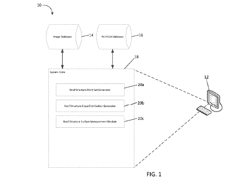
Turning to the drawings, FIG. 1 is a diagram illustrating an embodiment of the
system 10 of the present disclosure. The system 10 could be embodied as a
central
processing unit 12 (processor) in communication with an image database 14
and/or a point
set database 16. The processor 12 could include, but is not limited to, a
computer system,
a server, a personal computer, a cloud computing device, a smart phone, or any
other
suitable device programmed to carry out the processes disclosed. The system 10
could
generate at least one point set of a structure based on a structure present in
at least one
image obtained from the image database 14. Alternatively, as discussed below,
the system
could retrieve at least one stored point set of a structure from the point set
database 16.
The image database 14 could include digital images and/or digital image
datasets
comprising ground images, aerial images, satellite images, etc. Further, the
datasets could
include, but are not limited to, images of residential and commercial
buildings. The
database 16 could store one or more three-dimensional representations of an
imaged
location (including structures at the location), such as point clouds, LiDAR
files, etc., and
the system could operate with such three-dimensional representations. As such,
by the
terms "image" and "imagery" as used herein, it is meant not only optical
imagery
(including aerial and satellite imagery), but also three-dimensional imagery
and computer-
generated imagery, including, but not limited to, LiDAR, point clouds, three-
dimensional
images, etc.
CA 03208822 2023-07-18
WO 2022/159592 PCT/US2022/013143
6
The processor 12 executes system code 18 which estimates an area and a slope
of a
roof structure based on a point set of a region of interest received from the
point set
database 16 having a structure and corresponding roof structure present
therein. For
example, illustrated in FIG. 2 is a diagram 30 illustrating a region of
interest point set 40
having a structure 42 and corresponding roof structure 44 present therein.
Referring back to FIG. 1, the system 10 includes system code 18 (i.e., non-
transitory, computer-readable instructions) stored on a computer-readable
medium and
executable by the hardware processor 12 or one or more computer systems. The
code 18
could include various custom-written software modules that carry out the
steps/processes
discussed herein, and could include, but is not limited to, a roof structure
point set
generator 20a, a roof structure slope distribution generator 20b, and a roof
structure surface
measurement module 20c. The code 18 could be programmed using any suitable
programming languages including, but not limited to, C, C++, C#, Java, Python
or any
other suitable language. Additionally, the code 18 could be distributed across
multiple
computer systems in communication with each other over a communications
network,
and/or stored and executed on a cloud computing platform and remotely accessed
by a
computer system in communication with the cloud platform. The code 18 could
communicate with the image database 14 and/or the point set database 16, which
could be
stored on the same computer system as the code 18, or on one or more other
computer
systems in communication with the code 18.
Still further, the system 10 could be embodied as a customized hardware
component such as a field-programmable gate array ("FPGA"), application-
specific
integrated circuit ("ASIC"), embedded system, or other customized hardware
components
without departing from the spirit or scope of the present disclosure. It
should be
understood that FIG. 1 is only one potential configuration, and the system 10
of the present
disclosure can be implemented using a number of different configurations.
FIG. 3 is a flowchart illustrating overall processing steps 50 carried out by
the
system 10 of the present disclosure. Beginning in step 52, the system 10
selects roof
structure points from a point set of a region of interest. In particular, the
system 10 selects
roof structure points having a high probability of being positioned on a top
surface of a
structure present in the region of interest point set. In step 54, the system
10 determines a
footprint of the structure associated with the selected roof structure points.
Then, in step
CA 03208822 2023-07-18
WO 2022/159592 PCT/US2022/013143
7
56, the system 10 determines a distribution of the slopes of the roof
structure points. In
step 58, the system 10 generates a slope distribution report indicative of
prominent slopes
of the roof structure and their respective contributions toward (percentages
of composition
of) the total roof structure. Lastly, in step 60, the system 10 determines an
area of the roof
structure based on the footprint of the structure and the slope distribution
report.
FIG. 4 is a flowchart illustrating step 52 of FIG. 3 in greater detail.
Beginning in
step 100, the system 10 partitions the region of interest point set 40 into
two point sets
based on whether points have a high probability of being positioned on a top
surface of the
structure 42. It should be understood that points having a high probability of
being
positioned on the top surface of the structure 42 can be selected by any
method that yields
a set of three-dimensional (3D) points spanning the roof structure 44 of the
structure 42.
For example, the points can be selected by utilizing a footprint of the
structure 42 in the
XY-plane, via a neural network that classifies points as being part of the
roof structure 44,
via a 3D convolutional neural network that processes the points and outputs a
voxel
representation of the roof structure 44 with the resulting roof structure
points being a
characteristic point of the voxel, or via a projection onto an image having
labeled pixels
indicative of the roof structure 44. In step 102, the system 10 generates a
roof structure
point set including the selected points having a high probability of being
present on the top
surface of the structure 42. In particular, outlier points (e.g., points that
do not have a high
probability of being positioned on the top surface of the structure 42) can be
removed
based on properties thereof including, but not limited to, point density
around a respective
point, a non-planar region, or an outlier removal algorithm utilizing prior
constraints
associated with common roof structure configurations. For illustration, FIG. 5
shows a
diagram 120 illustrating a roof structure point set 122 corresponding to the
roof structure
44 of the structure 42 of FIG. 2, generated by the system.
FIG. 6 is a flowchart illustrating step 54 of FIG. 3 in greater detail. In
step 140, the
system 10 determines a two-dimensional (2D) polygonal model indicative of a
footprint of
the structure 42 in the XY-plane corresponding to the roof structure point set
122. It
should be understood that the 2D polygonal model can be determined by any
suitable
method. For example, the system 10 can determine the 2D polygonal model by
determining a concave hull approximation of the roof structure point set 122
via an alpha
shape algorithm or by a neural network that processes the roof structure point
set 122 to
CA 03208822 2023-07-18
WO 2022/159592 PCT/US2022/013143
8
generate a 2D grid indicative of the footprint of the structure 42.
Alternatively, the system
may utilize an existing footprint of the structure 42 if the existing
footprint meets
minimum quality thresholds. In step 142, the system 10 can refine the 2D
polygonal
model utilizing prior constraints including, but not limited to, angles,
symmetry and
simplicity. For illustration, FIG. 7 shows a diagram 160 illustrating a
footprint 162 of the
structure 42 corresponding to the roof structure point set 122 of FIG. 5,
generated by the
system.
FIG. 8 is a flowchart illustrating step 56 of FIG. 3 in greater detail. In
step 180, the
system 10 determines a normal of each 3D point of the roof structure point set
122. It
should be understood that the normal of each point can be determined by any
suitable
method. For example, the system 10 can determine the normal of each point by
utilizing a
neural network (e.g., Pointnet) which receives each point, in addition to
optional features
thereof (e.g., color), and computes a normal for each point or by selecting a
set of points in
a region encompassing each point and determining a plane of the region via
principle
component analysis, singular value decomposition, Random Sample Consensus
(RANSAC) or a similar plane estimation algorithm.
In step 182, the system 10 orients each roof structure point normal such that
the z-
component is a positive number. In step 184, the system 10 optionally refines
the oriented
roof structure point normals based on constraints and/or prior knowledge of a
roof
structure including, but not limited to, a probable orientation of the roof
structure,
symmetry constraints, and any other prior knowledge of the roof structure. In
step 186, the
system 10 determines a slope of the roof structure at each roof structure
point utilizing the
oriented normal thereof. Then, in step 188, the system 10 removes outlier
slopes
determined to lie outside of a reasonable range of slopes of the roof
structure.
In step 190, the system optionally discretizes the slopes according to a
selected
resolution. Lastly, in step 192, the system 10 generates a histogram of the
slope values.
As discussed below in reference to FIG. 10, it should be understood that a
constant
multiplier and/or bias may be applied to the slope values based on
constraints.
FIG. 9 is a diagram 210 illustrating a histogram corresponding to the roof
structure
point set 122 of FIG. 5. As shown in FIG. 9, peaks 212a and 212b are
indicative of peak
values of the histogram. The system processes the histograms of the structure
point sets
122 as discussed in greater detail below in connection with FIG. 10. The
histogram values
CA 03208822 2023-07-18
WO 2022/159592 PCT/US2022/013143
9
indicate the estimated surface slopes (vertical rise over horizontal run)
represented in the
point cloud at a particular point.
FIG. 10 is a flowchart illustrating step 58 of FIG. 3 in greater detail. In
step 220,
the system 10 determines peaks of the histogram. In step 222, the system 10
optionally
applies at least one additional constraint to the peaks including, but not
limited to,
minimum peak prominence, peak spacing, or any constraint with respect to a
probable roof
slope distribution. As mentioned above, peaks are indicative of peak values of
the
histogram. In step 224, the system 10 determines whether to utilize the peak
values as
respective representative slope values of each peak. If the system 10 utilizes
the peak
values as the respective representative slope values of each peak, then the
process proceeds
to step 226. In step 226, the system 10 determines prominent slope values by
determining
a mean of the slopes that contribute to the peak histogram bucket.
Alternatively, if the
system 10 does not utilize the peak values as the respective representative
slope values of
each peak, then the process proceeds to step 228. In step 228, the system 10
determines a
width of each peak. For example, the system 10 determines a width left of a
peak and a
width right of the peak independently based on at least one of a prominence of
adjacent
peaks, a peak height threshold and a minimum number of samples. Then, in step
230, the
system 10 determines the prominent slope values by selecting slope values that
lie between
(a) the width left of the peak and the peak and (b) the width right of the
peak and the peak.
In step 232, the system 10 removes the slope values that do not contribute to
any
peak. Slope values that do not contribute to any peak are indicative of noise
and are
therefore removed. Then, in step 234, the system 10 determines an area
percentage of the
roof structure for each prominent slope value. In particular, the system 10
determines a
total number of slope values that contribute to each prominent slope value and
divides a
point count for each prominent slope value by the total number of slope values
that
contribute to each prominent slope value. It should be understood that the
system 10 can
optionally round prominent slope values to whole integers based on a common
standard
unit of measurement (e.g., inches per foot). In step 236, the system 10
generates a slope
distribution report. The slope distribution report can be represented as a
table which maps
prominent slope values to respective area percentages of a roof structure. For
example,
FIG. 11 is a table 240 illustrating a slope distribution report having
prominent slope values
242 and corresponding area percentages of a roof structure 244.
CA 03208822 2023-07-18
WO 2022/159592
PCT/US2022/013143
FIG. 12 is a flowchart illustrating step 60 of FIG. 3 in greater detail. In
step 260,
the system determines a slope correction factor for each prominent slope
value. In
particular, the slope correction factor is given by Equation 1 as follows:
h vis2 1
Equation 1
where s denotes the slope and is measured as a rise in elevation in the z
direction per unit
run in the XY-plane. In this regard, FIG. 13 is a diagram 280 illustrating the
slope
correction factor as a hypotenuse of a triangle with slope s as a base and 1
as a complement
base. Referring back to FIG. 12, in step 262, the system 10 determines an area
of the roof
structure based on an area of the structure footprint, the prominent slope
values and
corresponding area percentages of the roof structure from the slope
distribution report, and
the slope correction factor for each prominent slope value. In particular, the
area of the
roof structure is given by Equation 2 as follows:
A:::: *h)
( P3 * hs. )
Equation 2
where A denotes an area of the roof structure, a denotes an area of the
structure footprint, pi
denotes an area percentage of the roof structure at an ith slope value in the
distribution
slope report and hi denotes a slope correction factor at the ith slope value
in the distribution
slope report.
Alternatively, the system 10 may utilize the entire point slope distribution
to
determine an area of the roof structure given by Equation 3 as follows:
A
1===4
Equation 3
where A denotes an area of the roof structure, a denotes an area of the
structure footprint, N
denotes a number of roof structure points and hi denotes a slope correction
factor at the ith
point.
In step 264, the system 10 generates a roof structure measurement report that
includes, but is not limited to, the slopes and area of the roof structure
determined from the
roof structure point set 122. It should be understood that additional
measurements with
CA 03208822 2023-07-18
WO 2022/159592
PCT/US2022/013143
11
respect to the roof structure may be included in the roof structure
measurement report
including, but not limited to, roof heights, cave heights, ridge heights,
valley lengths, hip
ridge lengths, ridge lengths, or any other relevant roof structure
measurement.
FIG. 14 a diagram illustrating another embodiment of the system 300 of the
present
disclosure. In particular, FIG. 14 illustrates additional computer hardware
and network
components on which the system 300 could be implemented. The system 300 can
include
a plurality of computation servers 302a-302n having at least one processor and
memory for
executing the computer instructions and methods described above (which could
be
embodied as system code 18). The system 300 can also include a plurality of
image
storage servers 304a-304n for receiving image data and/or video data. The
system 300 can
also include a plurality of camera devices 306a-306n for capturing image data
and/or video
data. For example, the camera devices can include, but are not limited to, an
unmanned
aerial vehicle 306a, an airplane 306b, and a satellite 306n. The internal
servers 302a-302n,
the image storage servers 304a-304n, and the camera devices 306a-306n can
communicate
over a communication network 308. Of course, the system 300 need not be
implemented
on multiple devices, and indeed, the system 300 could be implemented on a
single
computer system (e.g., a personal computer, server, mobile computer, smart
phone, etc.)
without departing from the spirit or scope of the present disclosure.
Having thus described the system and method in detail, it is to be understood
that
the foregoing description is not intended to limit the spirit or scope
thereof. It will be
understood that the embodiments of the present disclosure described herein are
merely
exemplary and that a person skilled in the art can make any variations and
modification
without departing from the spirit and scope of the disclosure. All such
variations and
modifications, including those discussed above, are intended to be included
within the
scope of the disclosure.