Note: Descriptions are shown in the official language in which they were submitted.
WO 2022/194741
PCT/EP2022/056462
METHOD AND SYSTEM FOR PROVIDING A FERTILIZER RECOMMENDATION AND A MEASUREMENT
REGION AND LOCATION
TECHNICAL FIELD
The present disclosure relates to a system and method for determining a plant
status and providing a
fertilizer recommendation to crops in agricultural fields. The present
disclosure relates also to the
determination of suitable locations for measurements which allow the
fertilizer recommendation.
BACKGROUND
Determining the appropriate amount of fertilizer a crop needs is one of the
most important decisions
a farmer will encounter. A deficit in nitrogen will reduce yield, while an
excess will produce economic
losses and damage the environment. A deficit in other nutrients will lead to
crop defects and reduced
crop quality. Crops, however, present an in-field variability due to the
variance in parameters which
influence the growth and development of a crop (water, soil properties) and is
therefore
cumbersome to establish a fertilizer recommendation which might suit the whole
crop at optimum
levels.
Handheld devices for direct measurement of crop nitrogen levels are well known
in the prior art.
Some of these devices usually determine the chlorophyll (directly related to
nitrogen content) by
means of optical measurements. However, these devices can only determine the
plant status of a
single plant each time, therefore rendering the determination of variable rate
application of
fertilizers difficult. While there are several approaches for non-direct
determination of the nitrogen
content in plants (N-Sensor , GreenseekerA, wherein the sensing devices are
integrated in
agricultural machines which can be transported continuously over the field,
reaching a full
determination of the crop status over the whole field, these solutions are
expensive and therefore
not suitable for smallholders. Hence a low-cost approach is needed which makes
a variable
determination of the crop nutrition status over a whole field.
PRIOR ART
US 7,746,452 B2 shows a device for measuring a plant chlorophyll, nitrogen and
water levels,
comprising a PDA which allows the determination of the measurement location.
However, the
1
CA 03212238 2023- 9- 14
WO 2022/194741
PCT/EP2022/056462
approach in US 7,746,452 B2 merely registers and displays the location data to
the user to spot
differences in results (e.g. for a shaded hillside).
US 10,175,215 B2 discloses a different detecting device but a similar approach
regarding the usage of
GPS data. It merely highlights the advantages for spatio-temporal mapping,
tracking and analysis of
the results for further processing after the measurements have been carried
out.
Several other devices like the SPAD meter (produced by Minolta) or the N-
Tester of Yara
International ASA have been successfully used for nitrogen recommendations.
The SPAD-502Plus by
Konica Minolta is a portable measuring device for chlorophyll content of
leaves. SPAD-502Plus
determines the relative amount of chlorophyll present by measuring the
absorbance of the leaf in
two wavelength regions using two LED (light emitting diode) elements and one
silicone photodiode.
The prior art therefore forces the user or farmer to take a big number of
measurements in order to
spot differences within the agricultural field in a time-intensive manner. On
the other hand, if the
user or farmer does not have the time to carry out all those measurements
needed to ensure that
the measurements are representative of the true crop nutrient content, the
discussed systems will
only provide a local measurement which can be representative of a single
plant, but not of the whole
field. In worst case scenario, if only a few measurements could be provided,
and the location where
the measurements were taken at has a crop nitrogen content far away from the
average crop
nutrient content of the rest of the crop, a wrong nutrient recommendation will
be produced for the
whole crop, therefore causing losses and possible contamination.
SUMMARY
The current disclosure aims at providing solutions for the problems which the
use of such a device
entail. While direct readings offer the advantage of precision, it is
cumbersome to determine the
variability across a whole crop, since it would involve a great amount of
measuring points. Further,
depending on the location chosen for carrying out the measurements, these can
be not
representative of the general crop nutrition status. Due to the in-field
variability present in the
multiplicity of factors which determine the nutrition status of a crop, it
would be advantageous to
either prevent these non-representative readings by indicating the user/farmer
where the
measurements are to be conducted, or alternatively, compensate the
measurements taken at a
random location to achieve a variable nutrient recommendation which take into
account these in-
field variations.
According to a first aspect of the present disclosure, this and other
objectives are achieved by a
method for providing a fertilizer recommendation for a crop with a handheld
system comprising a
2
CA 03212238 2023- 9- 14
WO 2022/194741
PCT/EP2022/056462
crop nutrient detection device, wherein the method comprises the steps of
determining a crop
nutrient content by carrying out at least a measurement Mj by means of the
crop nutrient detection
device in at least one location (xj,yj) within the agricultural field;
determining the crop nutrient
detection device position at the at least one measurement location; receiving
data, wherein receiving
data comprises receiving field data of the agricultural field and receiving
remote spectral data from
at least a plurality of wavelengths of the agricultural field; processing the
data to obtain at least one
coefficient indicative of the crop status within the agricultural field;
generating a fertilizer
recommendation for the crop within the agricultural field based on the
determined crop nutrient
content, the determined position of the crop nutrient detection device and the
at least one
coefficient indicative of the crop status within the agricultural field.
Following this approach, in-field variabilities in crop nutrition status of a
crop can be accounted for.
According to a further embodiment, the method further comprises generating the
fertilizer
recommendation using the determined crop nutrient content in the at least one
location as baseline
value for the agricultural field, and adjusting the fertilizer recommendation
at a given location of the
agricultural field based on the value of the at least one coefficient in the
given location.
Following this approach, the precise value of the direct measurement of the
crop nitrogen device
calibrates the remote data.
According to a further embodiment, the method further comprises receiving farm
and/or weather
data, and generating a fertilizer recommendation for the crop within the
agricultural field further
comprises adjusting the fertilizer recommendation based on at least one of the
received field, farm
and/or weather data.
Following this approach, different application approaches can be achieved
depending on further
properties of the agricultural field.
According to a further embodiment, the method further comprises determining
the fertilizer
recommendation for a given location NREC (Xj,yj) based on a plurality of
measurements M at locations
(xi, yj) is defined by the following equation: NREc yi) = f(M(xj, 30) + C *
g[R(xi, yi) ¨
wherein f represents an agronomic calibration function that translates the at
least one measurement
value of the crop nutrient detection device into a baseline value fertilizer
recommendation; g
represents an agronomic calibration function that translates the value R of
the at least one
generated coefficient at (xi,yi) into a respective location dependent
fertilizer recommendation, R
represents the value of the at least one coefficient or a combination thereof
considered at position
(xi,y;), and C and Ro represent calibration constants.
3
CA 03212238 2023- 9- 14
WO 2022/194741
PCT/EP2022/056462
Following this approach, the fertilizer recommendation can be calibrated.
According to a further embodiment, the method further comprises using the
fertilizer
recommendation is used for controlling one or more agricultural machines to
perform one or more
fertilizing operations within the agricultural field.
Following this approach, the fertilizer recommendation can be implemented in
the agricultural fields.
According to a second aspect of the present disclosure, this and other
objectives are achieved by a
computer implemented method for determining at least one measurement region
for carrying out at
least one measurement with a crop nutrient detection device for providing a
fertilizer
recommendation to a crop, comprising the steps of determining an agricultural
field comprising the
crop for which the recommendation is intended and receiving data, wherein
receiving data
comprises receiving field data of the agricultural field and determining at
least one measurement
region within the agricultural field for carrying out the at least one
measurement based on the field
data.
Following this approach, a measurement region where to conduct the
measurements is adapted to
the field conditions.
According to a further embodiment, the method further comprises receiving
remote spectral data
from at least a plurality of wavelengths of the agricultural field, and the
method further comprises
the steps of processing the remote data to obtain at least a coefficient
indicative of the crop status
within the agricultural field and further determining the at least one
measurement region within the
agricultural field for carrying out the at least one measurement based on the
at least one coefficient.
Following this approach, a measurement region representative of a health
status condition can be
determined.
According to a further embodiment, the method further comprises determining at
least one
measurement location within the measurement region.
Following this approach, sampling locations within the measurement region can
be determined to
improve the reliability of the measurements, avoiding plant-based variations.
According to a further embodiment, the method further comprises determining a
region wherein a
value R of the at least one coefficient or a combination thereof is comprised
within a range of at least
one of the following: 0.7 RAvg < R < 0.85 RAvg, or 0.85 RAvg < R < 1.15 RAvg,
or 1.15 RAvg < R < 1.3 RAvg,
wherein RAvg, is defined as the average value within the agricultural field of
the at least one
coefficient.
4
CA 03212238 2023- 9- 14
WO 2022/194741
PCT/EP2022/056462
Following this approach, a specific fertilizer recommendation depending on
area-specific calibrations
can be achieved.
According to a further embodiment, the method further comprises receiving
geographic identifiers
regarding the geometry of the boundaries of the agricultural field, and
wherein determining the at
least one measurement region within the agricultural field further comprises
determining the at least
one measurement region based on the field data.
Following this approach, the measurement regions can be accurately determined
away from the
boundaries.
According to a further embodiment, the crop nutrient detection device
comprises a location unit and
the method further comprises receiving location data from the crop nutrient
detection device and
determining the at least one measurement region based on the location data.
Following this approach, a measurement region closer to the vicinity of the
farmers can be
determined.
According to a further embodiment, the method further comprises receiving crop
data and weather
data, wherein determining the at least one measurement region within the
agricultural field further
comprises determining the at least one measurement region based on the crop
and weather data.
Following this approach, a fertilization application limit date can be
determined, and the farmer can
react timely.
According to a further embodiment, the method further comprises receiving
weather forecast data
and wherein determining the at least one measurement region within the
agricultural field further
comprises determining the at least one measurement region based on the weather
forecast data.
Following this approach, the farmer can avoid scheduling fertilization
applications through practices
which are not indicated in view of the weather forecast.
According to a further embodiment, the method further comprises determining a
sub-area within
the agricultural field, where the at least one measurement region should be
contained.
Following this approach, the farmers can direct the search of the at least one
measurement region to
a predetermined area to their convenience.
According to a further embodiment, the method further comprises receiving farm
data and
determining the measurement region based on the farm data.
5
CA 03212238 2023- 9- 14
WO 2022/194741
PCT/EP2022/056462
Following this approach, farm data can be regarded for the placing of the at
least one measurement
region.
According to a further embodiment, the method further comprises receiving
remote spectral data
including receiving temporal series of the spectral data.
Following this approach, further parameters indicative of the crop status can
be taken into
consideration in order to improve the fertilizer recommendation or the
measurement region
determination.
According to a further embodiment, the method further comprises determining a
crop nutrient
content in at least one of the measurement regions and generating a fertilizer
recommendation.
Following this approach, an improved fertilizer recommendation can be achieve
upon subsequent
determination of the crop nutrient content in the measurement regions.
According to a further aspect of the present disclosure, this and other
objectives are achieved by a
computer implemented method for determining at least one measurement region
for carrying out
at least one measurement with a crop nutrient detection device for providing a
fertilizer
recommendation to a crop, comprising the steps of determining an agricultural
field comprising the
crop for which the recommendation is intended, receiving data, wherein
receiving data comprises
receiving field data and remote spectral data from at least a plurality of
wavelengths of the
agricultural field, the method further comprising the steps of processing the
remote data to obtain at
least a coefficient indicative of the crop status within the agricultural
field and further determining
the at least one measurement region within the agricultural field for carrying
out the at least one
measurement based on the at least one coefficient.
According to further aspects, a system, a data processing apparatus, a
computer-readable storage
medium, and a computer program product configured to carry out the above
discussed methods are
envisaged within the present disclosure.
According to a further embodiment, the system further comprises a display and
an input unit,
wherein the system further comprises a graphical user interface configured to
display the at least
one measurement region.
According to a further embodiment, the graphical user interface is further
configured to display a
plurality of measurement regions and is further configured to receive an input
for selecting at least
one from the at least one of the plurality of measurement regions displayed;
6
CA 03212238 2023- 9- 14
WO 2022/194741
PCT/EP2022/056462
Following this approach, the farmers can freely select from the available
measurement regions which
are suitable for carrying out the measurements.
According to a further embodiment, the system is further configured to display
weather forecast
data associated with the at least one measurement region.
Following this approach, the farmers can consider weather conditions when
selecting the at least one
measurement regions.
According to a further embodiment, the system is further configured to receive
farm data and display
at least one scheduled task, wherein the system is further configured to
display the at least one
measurement region, and different itineraries which include the at least one
measurement region
and at least one of the scheduled tasks displayed.
Following this approach, the farmers can plan accordingly their itineraries in
the agricultural field.
According to a further embodiment, the system is further configured to receive
an input for
determining at least one predetermined area of the agricultural field and the
system is further
configured to determine the at least one measuring region within the at least
one predetermined
area.
Following this approach, the farmers can direct the search of the at least one
measurement region to
a predetermined area to their convenience.
BRIEF DESCRIPTION OF THE FIGURES
The accompanying drawings, which are included to provide a further
understanding of the present
disclosure and are incorporated in and constitute a part of this
specification, illustrate embodiments
of the disclosure and together with the description serve to explain the
principles of the disclosure.
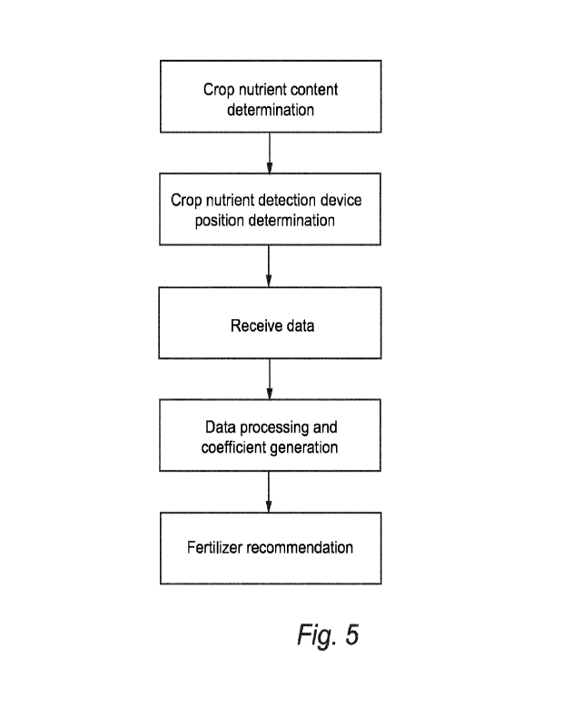
Figure 1 shows a system according to an embodiment of the present disclosure.
Figures 2a and 2b show an exemplary use of the different systems of the
current embodiment.
Figure 3 shows a representation of the value of the at least one coefficient
computed from remote
data in an agricultural field.
Figures 4a-d show a graphical user interface according to different
embodiments of the current
disclosure.
Figures 5 and 6 show workflows of two of the embodiments of the present
disclosure.
7
CA 03212238 2023- 9- 14
WO 2022/194741
PCT/EP2022/056462
The accompanying drawings are used to help easily understand the technical
idea of the present
disclosure and it should be understood that the idea of the present disclosure
is not limited by the
accompanying drawings. The idea of the present disclosure should be construed
to extend to any
alterations, equivalents and substitutes besides the accompanying drawings.
DETAILED DESCRIPTION
As used below in this text, the singular forms "a", "an", "the" include both
the singular and the
plural, unless the context clearly indicates otherwise. The terms "comprise",
"comprises" as used
below are synonymous with "including", "include" or "contain", "contains" and
are inclusive or open
and do not exclude additional unmentioned parts, elements or method steps.
Where this description
refers to a product or process which "comprises" specific features, parts or
steps, this refers to the
possibility that other features, parts or steps may also be present, but may
also refer to
embodiments which only contain the listed features, parts or steps.
The enumeration of numeric values by means of ranges of figures comprises all
values and fractions
in these ranges, as well as the cited end points. The term "approximately" as
used when referring to
a measurable value, such as a parameter, an amount, a time period, and the
like, is intended to
include variations of +/- 10% or less, preferably +/-5% or less, more
preferably +/-1% or less, and still
more preferably +/-0.1% or less, of and from the specified value, in so far as
the variations apply to
the disclosure disclosed herein. It should be understood that the value to
which the term
"approximately" refers per se has also been disclosed.
Unless defined otherwise, all terms present in the current disclosure,
including technical and
scientific terms, have the meaning which a person skilled in the art usually
gives them. For further
guidance, definitions are included to further explain terms which are used in
the description of the
disclosure.
In Figure 1, an example of a system according to the present disclosure is
represented. Figure 1
depicts an agricultural field comprising a crop within an agricultural region
with other systems and
apparatus with which the system 100 may interoperate. A system 100 according
to the present
disclosure comprises a crop nutrient detection device 110 and a communication
unit 120.
8
CA 03212238 2023- 9- 14
WO 2022/194741
PCT/EP2022/056462
Crop nutrient detection devices as the ones discussed in the prior art above,
present different
constructional arrangements. Some embodiments of these devices comprise an own
communication
unit or are operably connected to a mobile communication device like a
smartphone or tablet which
functions as communication unit, as pointed in the prior art. In other
embodiments, the devices are
peripherals attached to the mobile communication device, using a camera of the
mobile
communication device as optical detection unit, basing respectively the
determination of the crop
nutrient content on the reflectivity or transmissivity of the leaves at
specific wavelengths. However,
no specific determination of the detection principle is intended for the goal
of the current disclosure,
since the specificities of the detecting principle is not intrinsically
related to the advantages provided
by the current disclosure.
Communication unit 120 may therefore be a dedicated unit integrated with the
crop nutrient
detection device 110 or a separate electronic device operably connected to the
crop nutrient
detection device 110. In some embodiments, the crop nutrient detection device
110 may be a
peripheral device operably connected or integrated with a mobile phone. In a
further embodiment
system 100 may be a handheld mobile device. Different examples of these
embodiments would be
represented by already existing devices of the applicant like the N-Tester BT
, the N-Tester Clip and
Yaralrix , which are incorporated here by reference.
While the N-Tester BT and the N-Tester Clip are based on the change of light
intensities in certain
wavelengths upon light transmission through a plant leaf, VaraIrix is based
on ground-based
photographs of plant canopies taking into account sun's light reflectivity. As
mentioned above, all
embodiments are considered for the current disclosure since the detection
method principles does
not compromise the approach of the current disclosure.
System 100 comprises several components such as a processor 160, a wireless
communication unit
120, a location determining unit 150, a memory unit 165, a display 130 and an
input unit 140, which
might be combined as a touch sensitive screen 135.
System 100 may further comprise an agricultural recommendation engine 210 to
which the system is
remotely connected by means of the communication unit. Agricultural
recommendation engine 210
may be represented by a computer, a remotely accessible server, other client-
server architectures or
any other electronic devices usually encompassed under the term data
processing apparatus.
Agricultural recommendation engine 210 may comprise field and farm data and
external data,
whereby external data comprises weather data and further data provided by
weather forecast
providers or other third parties. Field data may comprise amongst others,
field and geographic
identifiers regarding the geometry of the boundaries of the agricultural
field, including the presence
9
CA 03212238 2023- 9- 14
WO 2022/194741
PCT/EP2022/056462
of areas within the agricultural field which are not managed, topographic
data, crop identifiers (crop
variety and type, growth status, planting data and date, plant nutrition and
health status), harvest
data (yield, value, product quality, estimated or recorded historic values),
soil data (type, pH, soil
organic matter (SOM) and/or cation exchange capacity, CEC) as well as historic
series of the data.
Farm data may comprise further data regarding to planned and past tasks like
field maintenance
practices and agricultural practices, fertilizer application data, pesticide
application data, irrigation
data and other field reports as well as historic series of the data, allowing
the comparison of the data
with past data, and further administrative data like work shifts, logs and
other organizational data.
Planned and past tasks may comprise activities like surveillance of plants and
pests, application of
pesticides, fungicides or crop nutrition products, measurements of at least
one farm or field
parameter, maintenance and repair of ground hardware and other similar
activities.
The agricultural recommendation engine 210 may be configured to retrieve soil
data from available
online soil databases like SoilGrids from the World Soil Information, SSURGO
(Soil Survey Geographic
Database from the United States Department of Agriculture) or any similar soil
data repository.
System 100 may be further configured to receive any of the above-mentioned
data and further field
data from a predetermined number of locations within or nearby the analyzed
region, inputted
manually by the users/farmers by means of the input unit 140 or received by
the communication unit
120 from dedicated sensors 170. Further, system 100 and agricultural
recommendation engine 210
may be configured to receive weather data from nearby weather stations 180
and/or external
crop/farm sensors 170, as well as by means of the input unit 140. Nearby
weather stations 160
and/or external crop/farm sensors 170 are configured to communicate via one or
more networks. In
another embodiment, weather data is provided by external weather forecast
companies. Weather
data may further include present and past temperatures, accumulated
precipitation, relative
humidity, wind speed, solar radiance, accumulated sun hours, etc.
System 100 may further be operatively connected to an agricultural apparatus
200. Examples of
agricultural apparatus 200 include tractors, combines, harvesters, planters,
trucks, fertilizer
equipment, and any other item of physical machinery or hardware, typically
mobile machinery, and
which may be used in tasks associated with agriculture. In one embodiment,
system 100 may be
configured to communicate with the agricultural apparatus 200 by means of
wireless networks in
order to set a variable rate application prescription for the determined crop,
or alternatively, to
determine the measurement region as indicated destination. System 100 may be
further configured
to produce a downloadable script file for the agricultural apparatus to carry
out the fertilizer
application.
CA 03212238 2023- 9- 14
WO 2022/194741
PCT/EP2022/056462
Figures 2a-b show examples of the use of a system according to embodiments of
the current
disclosure. Figure 2a shows an embodiment of the current disclosure where the
communication unit
120 and the crop nutrient detection device 110 are different elements. Crop
nutrient detection
device 110 is operatively connected to the communication unit by means of a
suitable wireless
connection. Figure 2b shows a further embodiment of the current disclosure
where the system is
formed by a mobile phone and a peripheral element operatively connected to the
mobile phone
enables the mobile phone to determine the crop nutrient level based on the
transmissivity of light
through the plant leave 10 situated in between. The farmer, when in a field,
is able of determining
the plant nutrient content by directly analyzing one or more leaves 10 of a
plant present in the
agricultural field. The farmers, when directly measuring the plant nutrient
content by means of the
crop nutrient detection device, can rely on their knowledge to determine
plants which show a
healthy status (no discolored leaves or abnormally looking plant). The farmers
might take a plurality
of measurements within an area, hoping to collect enough measurements which
can be
representative of the crop nutrient content within the agricultural field.
However, in spite of the best
intentions and knowledge of the farmers, they cannot be aware of the
variability across the
agricultural field due to in-field variabilities across the field of several
parameters (soil properties and
sub-soil water conditions among others), and can therefore unwillingly collect
a crop nutrient
content based on these measurements which are not representative of the
average crop nutrient
content for the whole crop. While it is feasible to take enough measurements
to cover the whole
agricultural field, it would require an enormous amount of work from the
farmers. As such, while
non-destructive direct measurements can be very accurate in a very local and
restricted way, there is
a need to improve the accuracy of fertilizer recommendations for the crop
across the whole
agricultural field reducing the amount of work the farmers are required to put
in.
The current disclosure aims at solving this problem by means of alternate
solutions. On one hand,
when the farmer is on-site, the current disclosure aims at enhancing
fertilizer recommendations for
the measurements which might be carried out by the farmer at need at a given
location.
Alternatively, the farmer may be pointed and directed to at least one
measurement region for
carrying out the measurements wherein the average crop nutrient content is
representative for the
type of fertilization procedure intended. For example, the farmers, at the
start of their days, when
planning the tasks and activities to be carried out on the agricultural field
may determine a
measurement region where it would be of advantage to carry out the
measurements. Hence, the
current disclosure, aiming at providing different solutions to the farmer for
improving current
methods, offers further advantages with regard to the prior art.
11
CA 03212238 2023- 9- 14
WO 2022/194741
PCT/EP2022/056462
Figure 3 shows an embodiment of remote data representing the values of one of
the plurality of
coefficients generated from the remote data including at least a plurality of
wavelengths, showing
the distribution over the agronomic field and the in-field variabilities.
The present application makes use of suitable remote data for determining the
in-field variability of
the crop nutrient content. Remote data can be referred to data provided by
imaging satellites 250 or
suitable manned or unmanned imaging aerial vehicles 260. These satellite or
vehicle systems are
configured to communicate by means of dedicated networks and usual methods
which do not need
being disclosed herein. Amongst the different remote data available for use,
satellite data is
nowadays widely available from numerous public (LANDSAT from NASA, SENTINEL
from ESA) and/or
private providers. The present method is however not limited to a satellite
data platform, since the
spectral bands which can be of use for the present method are provided in a
big range of the
standard satellite data and can as well be provided by means of drones or
other unmanned aerial or
terrestrial vehicles with image sensors in the required spectral bands or a
combination thereof. Due
to the differences present across different satellite and optical sensor
platforms, it is hereby not
intended to limit the support of the current disclosure to exact and specific
wavelengths and the
given wavelengths are provided for orientation. While different factors and
corrections can be
introduced to account for these variabilities, the use of wavelengths
proximate to the ones
mentioned below should be understood since the specifications of said
platforms vary accordingly.
In an embodiment, remote data is obtained from the Sentinel-2 satellite. The
Sentinel-2 mission
contains a MSI (Multi Spectral Instrument) that takes high spatial resolution
data in order to monitor
Earth's surface. The MSI works passively, by collecting sunlight reflected
from the Earth and is
therefore a more efficient and less energy consuming detection method.
Sentinel-2 consists of 13
bands with different spatial resolutions (10m, 20m or 60m), in the visible,
near infrared, and short-
wave infrared part of the spectrum. In an embodiment, the current method uses
the image data
related to spectral bands with at least a plurality of wavelengths comprised
approximately between
700 and 850 nm. In a further embodiment, the present method uses data related
to spectral bands
with a wavelength of approximately 740 and 780 nm. The use of Sentinel-2
spectral bands from the
MSI produces measurements with a high resolution (approx. 20 m) and is
therefore preferred for the
implementation of the current disclosure. However, Sentinel-2 data is not
available on cloudy days.
In this sense, although less precise, the current disclosure may comprise the
use of remote data from
Sentinel-1 or other active SAR satellites which can be used in cloudy days.
However, the current
disclosure offers the further advantage that in order to achieve an accurate
nitrogen
recommendation, there is no need for having a very recent image. In-field
variability usually remains
constant or has slower dynamics, provided the absence of locally limited pests
or other events.
12
CA 03212238 2023- 9- 14
WO 2022/194741
PCT/EP2022/056462
In an embodiment, remote data comprises data relating to different spectral
bands are used for
improving the determination of the present method. For example, the normalized-
difference snow
index (NDSI) comprises the use of spectral bands around the values of 530-610
nm (visible green) and
1550-1750 nm (short-wave infrared, SWIR) in order to determine areas covered
by snow. Snow cover
is as bright as the clouds, and this makes it difficult to differentiate it
from the cloud cover. However,
at around 1600 nm, snow cover absorbs sunlight and it appears therefore darker
than the clouds.
This enables an effective distinction between clouds and snow cover. Further
compensation and
calibration algorithms are considered in the present application, depending on
the nature and origin
of the remote data. In one embodiment, remote data is preprocessed for cloud
and haze removal
and light calibration, which is of advantage may the remote data be provided
by means of a satellite
as described above. In another embodiment, when the remote data is provided by
a manned or
unmanned aerial vehicle or drone, cloud correction is not needed, but
different light compensation
procedures are envisaged to compensate for the sunlight characteristics and
sun relative position.
Once the remote data has been received, wherein the remote data comprises
imagery data from at
least a determined location comprising a plurality of spectral bands or
optical domains of different
wavelengths, the system is configured to generate at least one coefficient
derived from the remote
data. Different coefficients (or indexes) have been used in the literature for
obtaining different
agricultural, soil and vegetation information like the difference vegetation
index and the normalized
difference vegetation index (NDVI). However, NDVI is sensitive to the effects
of soil brightness, soil
color, atmosphere, clouds, cloud shadows, and leaf canopy shadows and requires
remote sensing
calibration. In that sense, further coefficients contemplated may comprise the
Atmospherically
Resistant Vegetation Index (ARVI) to reduce the dependence of atmospheric
effects; the Soil-
Adjusted Vegetation Index (SAVI) or the Type Soil Atmospheric Impedance
Vegetation Index (TSARVI)
which take into consideration the distinction of vegetation from the different
types of soil
background. Apart from the standard vegetation indexes comprised in the state
of the art, the
present application may make use of two further indexes which will be
described in more detail
below.
In order to provide a reliable vegetation index or coefficient which is
indicative of the chlorophyll
content present in the vegetation, the further indexes of the application may
include different
wavelengths at the so-called red edge of vegetation between 670 and 840 nm.
In a further embodiment, in order to provide a reliable vegetation index or
coefficient which is
indicative of the water content present in the vegetation, the remote data may
comprise a further
13
CA 03212238 2023- 9- 14
WO 2022/194741
PCT/EP2022/056462
remote data comprising further wavelengths at or close to water absorption
bands, such as around
950nm, 1100, 1450 or 1950 nm in order to determine the canopy water content.
Hence, formulations of a vegetation index according to the present
considerations can be expressed
as any suitable combination or a mathematical relation of different signals of
different wavelengths,
like for example the NDVI, which can be expressed as:
NIR¨ RED
NDVI = ______________________________________________
NIR + RED'
wherein NIR and RED represent the data relating to the respective wavelengths
of near infrared
and red bands, or values closest to them in the respective satellite platform
as explained above.. The
present index is therefore sensitive to the chlorophyll content present in the
vegetation and a direct
relationship with the total amount of nitrogen within the canopy can be
directly derived.
Further, instead of, or in addition to, determining chlorophyll, dry fresh
biomass can be determined.
The biomass determination can be independent of chlorophyll. Fresh biomass
can, e.g., be calculated
from corresponding vegetation index like the Leaf Area Index (LAI), which can
be defined as follows:
NIR
LAI =
RED + SWIR'
wherein NIR and RED represent as above the data relating to the respective
wavelengths of near
infrared and red bands and SWIR represents the short-wave infrared..
Determining the chlorophyll
content, directly related to the crop nitrogen content, and the dry fresh
biomass, a more accurate
nutrient recommendation including other elements like potassium or phosphorus
can be carried out.
The above listed coefficients are merely some of the suitable ones to carry
out the method of the
current disclosure. However, the list of coefficients (or indexes) is not
meant to be limiting. There is a
great variance of different coefficients which are as well able of being used
by the present method,
as mentioned above for computing other properties of agronomical fields (e.g.,
soil moisture) which
although not directly indicative of crop nutrient content, assist the
determination of a fertilizer
recommendation by improving further insights into other field parameters.
In a further embodiment, remote data may further comprise temporal series of
the remote spectral
data for determining the corresponding coefficient or vegetation indexes which
enable determining
other parameters which might influence or reflect the crop status and the
fertilizer recommendation.
For example, receiving temporal series of the current and/or previous crop
seasons of the remote
spectral data may be used to identify, e.g., crop type and yield from previous
crop seasons or a yield
forecast for the present crop season, wherein the agricultural field may have
been used for different
crop types in the past. Further, high yield areas of previous seasons within
the agricultural field can
14
CA 03212238 2023- 9- 14
WO 2022/194741
PCT/EP2022/056462
be determined in order to improve the fertilizer recommendations and/or to
guide the farmers to
these areas to assess specific fertilizer needs.
Once the at least one coefficient indicative of the crop status within the
agricultural field has been
generated the determination of different factors like chlorophyll, nitrogen
uptake and biomass
amongst others may be accounted for generating a location dependent nutrient
recommendation
which takes into consideration the infield variability of the crop status
within agricultural field, as will
be explained below.
When the farmers collect at least a measurement Mj at a determined location
(xj,y) within the
agricultural field, the present system is configured to determine a baseline
value for the fertilizer
recommendation in such a way that an accurate recommendation, based on direct
crop nutrient
measurement is achieved. In order to take into account the infield variability
present in the crop, a
further term, based on the coefficient generated from the remote data is
added. As such, the
fertilizer recommendation for a given location NREC (Xi Ni) based on a
plurality of measurements M at
locations (xi, yj) may be defined by the following equation:
NREC = f (1\1(xj,yi)) + C * g[R(xi,yi) ¨ R0],
wherein f represents an agronomic calibration function that translates the at
least one measurement
value of the crop nutrient detection device into a baseline value fertilizer
recommendation, g
represents an agronomic calibration function that translates the value of the
at least one generated
location dependent coefficient into respective location dependent fertilizer
recommendation, R
represents the value of the at least one coefficient or a combination thereof
considered at position
(xi,y;), and C and Ro represent calibration constants. Agronomic calibration
functions f and g may
further receive farm and field data regarding additional agronomic parameters
like growth stage,
crop type, variety, etc. to improve the recommendations, as well as historic
data. While NREC and
therefore the values provided by f and C * g are scalar values in the case in
which a single nutrient is
recommended, the current formula may be expressed in a vector-matrix form
wherein each nutrient
element can be accounted for row-wise. In this embodiment, calibration
constant C may comprise a
vector with as many elements as nutrients considered. In a further embodiment,
calibration constant
C may comprise a matrix which takes into consideration cross-coupling effects
of the at least one
generated coefficient, wherein Cu represents the matrix element in row i and
column j, which
represents a further calibration parameter depending on the respective
coefficient and their
relationship with the respective nutrient.
Agronomic calibration function f may further comprise processing the
measurements carried out by
the crop nutrient detection device. Although the current method is intended to
support the farmers
CA 03212238 2023- 9- 14
WO 2022/194741
PCT/EP2022/056462
when only a single measurement is carried out, the method of the current
disclosure may comprise
in this approach to determine a plurality of measurement locations distributed
inside a measurement
region which is determined by the current position of the farmers. Hence, f
may further comprise
carrying out averaging techniques for the plurality of measurement locations
within a measurement
region.
References in the current application regarding the step of carrying out at
least one measurement
with a crop nutrient detection device are not intended to limit the scope of
the present application.
While it has been made reference throughout the description to the farmers
carrying out the
measurements, any action leading towards a determination of a crop nutrient
status at a specific
location as intended by the method of the current disclosure is considered as
a possible embodiment
within the teachings of the current application and it must not include the
action of a farmer or
further actor. For example, determining a crop nutrient content by carrying
out at least a
measurement may only comprise receiving measurement data by means of a
communication unit or
a ny suitable network which represent the crop nutrient status of the measured
crop at the
predetermined position by means of a crop nutrient device according to the
different embodiments
present in the current application.
Alternatively, the farmers will be provided with a measurement region where to
carry out the
measurements. The farmers, when on-site, and depending on the type of crops,
might only have a
visual reach of a couple rows of crop and does not have an overall view of the
general nutrition
status of the crop. When deciding to sample for convenience around the area
the farmers are at,
they might choose an unsuitable spot for carrying out the measurements.
Usually, when reaching the
agricultural field, farmers choose a region which is easily accessible, close
to the borders of the
agricultural region. However, boundary regions in agricultural fields are not
representative of the
whole crop nitrogen status. Local regulations and other constraints from
fertilizing machinery and
agricultural works render fertilization uneven. Fertilizing outside of field
boundaries may be
forbidden due to environmental constraints. Due to the more frequent passage
of heavy vehicles on
the boundaries of the fields, soil is compacted and degraded, from which the
crop closest to the
boundary suffer. Further, remote data comprising imagery from the agricultural
field 20 gets less
representative towards the boundaries due to the above-mentioned effects and
further data
processing steps, which due to the discontinuities generated by the shape of
the farm can cause
further noise arising from the remote data. Moreover, farm field geometry
variations within the
boundaries have further impacts regarding both remote data and crop nutrition
status and therefore
should be taken into account. As such, the current disclosure, while aiming at
providing a suitably
accessible location to the farmers, due to the consideration of the
agricultural field boundary and/or
16
CA 03212238 2023- 9- 14
WO 2022/194741
PCT/EP2022/056462
remote data, can provide measurement regions conveniently close to the
boundary for the farmers
which are representative of the average and general crop nutrient status,
improving the accuracy of
a fertilizer recommendation for the crop over the whole agricultural field or
a sub-area of it.
However, the current method is not limited to finding measurement regions near
the border, since
due to other operational constraints, areas well within the agricultural field
may be of interest, as it
will be made clear below.
Figures 4a-d refer to the embodiments of the current disclosure in which the
farmers are
alternatively provided with at least a measurement region 300 for carrying out
the measurements as
explained.
System 100 is configured to determine an agronomical field containing the crop
for which the
measurements are intended. In a further embodiment, a sub-area of the
agronomical field may be
defined to contain the measurement regions if only area-specific treatments
are intended.
Determining an agronomical field may comprise receiving inputs from the
farmers via the input unit
to manually select a specific field of interest for the farmers. Determining
an agronomical field may
comprise determining the agronomical field based on field data, crop data
and/or weather data. As it
will become apparent, the current system may determine a fertilizer
application limit date for a
plurality of fields, wherein the system is configured to determine an
agronomical field based on the
fertilizer application limit date. Determining an agronomical field may
further comprise automatically
detecting, based on the crop nutrient detection device location and the field
data, the agronomical
field where the farmers are.
In an embodiment, determining the at least one measurement region in the
agronomical field for
carrying out at least a measurement is based on the field data. Field data may
comprise amongst
others, field and geographic identifiers regarding the geometry of the
boundaries of the agricultural
field, including the presence of areas within the agricultural field which are
not managed,
topographic data, crop identifiers and the like. As such, the current method
offers a straightforward
determination based on the geometry on the field and can therefore avoid
boundary regions.
In an embodiment, the measurement region is determined based on the remote
data representative
of the crop status as explained above. Once the remote data has been processed
to obtain at least
one coefficient (R) indicative of the crop or soil status, the current method
determines the
measurement regions based on the coefficient. Further, the current method may
further determine
measurement regions where R is comprised between a predetermined range.
Depending on the type
of fertilizer application intended, R maybe defined to be within a range of
0.7 RAvg < R < 0.85 RAvg, or
17
CA 03212238 2023- 9- 14
WO 2022/194741
PCT/EP2022/056462
0.85 RAvg < R < 1.15 RAvg, or 1.15 RAvg < R < 1.3 RAõ,, wherein RAvg is
defined as the average value within
the agricultural field of the at least one coefficient or combination thereof.
Ranges may as well be
defined otherwise. In fields with crops with little variability, these ranges
made be defined to be
comprised preferably within a range of 0.9 RAvg < R <0.975 RAvg, or 0.975 RAvg
< R < 1.025 RAvg, or
1.025 RAvg < R < 0.9 RAvg. Moreover, ranges may be defined dynamically,
wherein each individual
range may be determined proportional to the standard deviation of R. The
farmers, when aiming for
a fertilizer recommendation, may want to create area-specific application of
fertilization. For
example, a levelling or a boosting approach can be envisaged, wherein only
zones having a higher or
a lower nutrient level are fertilized to either bring the lower areas up to a
certain nutrient level, or
avoiding to fertilize areas which due to external reasons are not able of
taking up the nutrients.
Hence, in order to determine said specific application of fertilizer, the
current method may comprise
determining the measurement regions such that the values of the at least one
generated coefficient
is comprised between the above-mentioned ranges. Further, system 100 may be
configured to
determine a sub-area within agricultural field 20 where the measurement region
should be
contained. In such a way, farmers can select areas of the crop where the
fertilizer application should
be carried out, from which the most suitable area for measurement will be
correspondingly
determined. This can be made based on farmers input or based on field and farm
data, regarding
specific issues of the field.
In a further embodiment, remote data used for the determination of measurement
regions may
further comprise temporal series of the remote spectral data for determining
the corresponding
coefficient or vegetation indexes which enable determining other parameters
which might influence
or reflect the crop status and the fertilizer recommendation. For example,
receiving temporal series
of the current and/or previous crop seasons of the remote spectral data may be
used to identify, e.g.,
crop type and yield from previous crop seasons or a yield forecast for the
present crop season,
wherein the agricultural field may have been used for different crop types in
the past. Further, high
yield areas of previous seasons within the agricultural field can be
determined in order to improve
the fertilizer recommendations and/or to guide the farmers to these areas to
assess specific fertilizer
needs.
In an embodiment, determining the at least one measurement region may be based
on their current
location and position within or nearby the agricultural field. In such a way,
a measurement region in
the vicinity of the farmer can be chosen which is representative of the crop
nutrition status.
In a further embodiment, once the at least one measurement region wherein the
farmer is supposed
to carry out the at least one measurement is determined, the system is further
configured to provide
18
CA 03212238 2023- 9- 14
WO 2022/194741
PCT/EP2022/056462
a plurality of measurement locations 310 with a predetermined pattern within
the measurement
region. The number of measurement locations 310 and the resulting shape which
these patterns
represent within the measurement regions are configured to ensure the sampling
quality of the
measurements while keeping the effort for sampling as low as possible. In a
further embodiment, a
measurement path 320 which connects the measurement locations 310 is
determined.
Due to the orientation, shape and further properties of the agricultural
field, measurement regions
300 and/or locations 310 can be adjusted to improve the fertilizer
recommendation based on the
measurements from the crop nutrient detection device. As mentioned above,
finding a suitable
location for a farmer can take different factors into consideration.
As an example, the shape of the agricultural field may include several
irregularities. While the usual
representation of an agricultural field for farming purposes may be shown as
of a regular rectangular
shape, due to the presence of trees, roads and driveways, rivers and
waterways, agricultural fields
might take very different shapes. As a result, the average nutrition status
around certain areas
cannot be considered to be representative of the general nutrition status of
the crop unless
otherwise accounted for. In a further embodiment, determining a measurement
region may be
based on the distance from the region to designated areas within the field.
For example, the
presence of angles at the agricultural field boundary influences differently
the average crop nutrition
status of the field. When an obtuse angle is formed by the agricultural farm
borders, when seen from
the inside of the agricultural field (i.e. the angle defined by the region
comprised between the two
lines which contains the agricultural field), a constant fertilizer spreading
rate may cause higher
nutrient concentrations at the zone close to the origin of the formed angle
than intended, whereas in
the case of acute angles, due to the inferior amount of terrain covered when
fertilizing around the
origin, a lower nutrient concentration occurs. This effect may however be
compensated or even
reversed due to the constructional limitations of fertilization machinery and
how the itinerary of the
fertilizer application device is designed. Same considerations are to be taken
analogously when
considering inner borders within the agricultural field, as well as to the
size of the regions not part of
the agricultural field while being inside the outer boundaries of the
agricultural field. Hence,
determining at least a measuring region may be based on the shape of the field
boundary. In a
further embodiment, determining at least a measurement region based on the
field boundary may
further comprise determining a distance to predefined areas, and determining
the at least one
measurement region based on the distance. Predefined areas may comprise any
area at the field
boundary or within the boundary which define a change to the geometry of the
agricultural field, like
boundary angles, non-farmed islands within the field due to trees, rocks or
other constraints and
other boundary irregularities. This embodiment offers the further advantage
that if remote data is
19
CA 03212238 2023- 9- 14
WO 2022/194741
PCT/EP2022/056462
not available due to network issues or availability problems, the method of
the current application
may still determine at least a measurement region avoiding field areas which
are usually not
representative of the average status. The advantages will become further
apparent in combination
with the below disclosed embodiments.
As shown in Figure 4b, the method of the current disclosure may determine a
plurality of
measurement regions which the farmers can select according to their
convenience. Moreover,
determining the at least one measurement region may further comprise the
inclusion of farm data
for the determination. In such way, the measurement regions 300 and locations
310 can be
determined taking into consideration different tasks which the farmers are
supposed to carry out,
based on the tasks location and scheduled time.
In this further embodiment, the method further comprises receiving farm data.
In this embodiment,
the method of the current disclosure may further comprise determining the at
least one
measurement region based on different planned or previous tasks. For example,
determining the at
least one measurement region based on scheduled tasks, the method of the
current disclosure may
determine suitable measurement regions which are located around the areas
where the scheduled
maintenance tasks are to be carried out which are still representative of the
crop status. In this
embodiment, the farmers could plan measurements ahead of time, along the
itineraries from one
scheduled task to another, minimally disrupting their work plan and always
achieving an optimal
region for carrying out the measurements. In another embodiment, the current
method may further
comprise determining at least one measurement region based on the areas where
different
scheduled tasks have been carried out. In this embodiment, the farmer may
follow up on the
outcome of the tasks carried out and their influence on the crop nutrient
content. In another
embodiment, the current method may further determine the measurement regions
based on past
measurements. Farm data may further comprise historic data of measurement
locations 310,
fertilizing applications or other agricultural practices, such that the system
may be configured to
determine the measurement regions 300 and/or locations 310 based on the farm
data to gain further
insights through the appropriate placement of a measurement region 300 and/or
locations 310
which can surveille the evolution and consequences of the practices carried
out, as well as
discovering trends within the crop nitrogen content by considering previous
measurement locations
310. In such a way, further insights can be gained for the calibration of
agronomical functions f and g.
In a further embodiment, the at least one measurement region and the at least
one measurement
location may be further determined based on field data. Field data may
comprise soil data from
different regions within the agricultural field. In this further embodiment,
the system may be
CA 03212238 2023- 9- 14
WO 2022/194741
PCT/EP2022/056462
configured to determine the at least one measurement region based on the soil
data, such that the
variance of the soil data can be taken into account for the determination of
the nitrogen crop
recommendation.
In a further embodiment, system 100 may be configured to use farm data, crop
data, field data and
weather data in order to determine the at least one measurement region.
Farmers, when managing a
farm with different fields which might present different crops, need to
schedule the fertilizer
applications and therefore the measurements according to the growth stage of
the crop. In this
embodiment, system 100 may be configured to determine a crop growth status of
each of the crops
present in the farming fields based on the planting date, the crop type and
weather data. Weather
data may comprise precipitation, sun hours, maximum and minimum daily
temperatures. Based on
these data, system 100 may determine measurement regions in the crops which
need earlier
application of fertilizer.
In a further embodiment, in order to gain further insights derived from the
crop growth status, the
system may further comprise a mechanistic growth model to increase the
robustness of the present
approach. A model is hereby understood to comprise a series of digitally
constructed equations or
parametrizations which can be used, upon the introduction of different values,
to represent data of
past, current or future events.
The present model may be generated using at least one of the data mentioned
above. While the
complexity of the model increases the reliability and the precision of the
modeled variables, in
specific cases linear models elaborated for simulating and surveilling a
single quantity suffice. In an
embodiment, the model may comprise past, present and predicted weather data,
as well as
atmospheric and environmental data and field data. Moreover, further local
sensed data can be
incorporated into the models as it will be made clear below. Although a model
is usually understood
as a set of mathematical equations, the present application is not designed to
be limited to such an
example and the models herein represented can be Al generated "black-box"
models, wherein the
use of common machine learning algorithms, like a Random Forest Model or any
other non-
parametric machine learning model, are envisaged. Models may be determined
upon setting certain
hypotheses with a great variety of tools and methods. For example, the use of
convolutional neural
networks (CNN) and/or the use of linear or non-linear regression models to
determine the
parameters and different coefficient which decide the model behavior are per
se well known from
the prior art and therefore will not be described in further detail herein. By
using these mechanistic
growth models for an agricultural field, it is expected to model the time
evolution or behavior of a
defined subset of field variables (e.g. in certain embodiments, plant growth
and yield, nutrient
21
CA 03212238 2023- 9- 14
WO 2022/194741
PCT/EP2022/056462
presence and concentration) which have a certain relation (either expressed
mathematically by
means of equations modelling physical phenomena or by means of transfer
functions) with respect
to other parameters or variables in the model. Hence, the present method
comprises determining
the at least one measurement region, based on the farm, field, crop data and
weather data, further
comprises using a mechanistic growth model to determine a nitrogen application
limit date and the
at least one measurement region is further determined based on the determined
limit date.
In another embodiment, determining the measurement regions comprises
determining the
measurement regions based on weather data or weather forecast data. When the
farmers have
already a planned fertilizer application, weather future conditions have to be
considered since rain
might affect the application of fertilizers due to leaching, while wind may be
considered for spraying
applications. Further, the choice of a measurement region can be improved by
avoiding areas with a
high water stress due to the thinning of the leaves and resulting chlorophyl
concentration. Hence,
determining at least one of the measurement regions well ahead in time before
a series of days with
adverse conditions can be planned in such a way that both the moment of the
application of the
fertilizer is taken into consideration, as well as the moment of carrying out
the measurements.
In a further embodiment, combining the two preceding ones, a further advantage
can be made
apparent. In the current embodiment, when having a limit date for a fertilizer
application and
weather forecast data, determining the at least one measurement region may
further comprise
determining one measurement region based on the limit date and the weather
forecast data. In this
embodiment, the farmers are provided with a further advantage, in which they
can plan fertilization
practices which although being quite ahead will not be able to be carried away
due to weather
conditions.
System 100 may further comprise a dedicated Graphical User Interface as shown
in Figures 4a-d
which helps the user in choosing the location of the measurement regions based
on the at least one
region determined and proposed by the system.
The farmers, when planning to measure the crop nutrient content within their
farms, might consider
more than just one field for the measurement, which may or may not be located
close to each other.
Together with the different tasks and measures planned, the scheduling might
involve a full day and
several kilometers. Hence, it is a further aim of the current disclosure to
improve the scheduling and
planning of the farm general tasks, while achieving a more reliable
measurement which further
allows a more reliable fertilizer recommendation.
In an embodiment as shown in Figures 4a-d, the current system may be an input
unit and output unit
combined as a touch sensitive display. However, while the system 100 is of a
mobile nature, the
22
CA 03212238 2023- 9- 14
WO 2022/194741
PCT/EP2022/056462
Graphical User Interface envisaged for the current system might be as well run
on a laptop or
desktop electronic device at the farm in preparation of the daily activities.
Hence, the scope of the
application for the current Graphical User Interface is not only limited to
mobile devices. Throughout
the disclosure, the system being configured to display is meant to be by means
of a dedicated
.5 Graphical User Interface displayed by means of the display unit.
The farmers, when planning to carry out the at least one measurement, may
first select at least one
field from a plurality of fields belonging to his farm. The fields may
comprise crops of the same or
different type. System 100 may be configured to display the at least one field
determined for carrying
out the at least one measurement. System 100, when displaying the at least one
field may further
display the location 30 of the farmers if in the view. System 100 may further
display by means of the
Graphical User Interface, when the farmer is not on the displayed view due to
scale or to the actual
position of the farmer, an icon 40 representative of the relative location of
the farmers. In this
embodiment, icon 40 defining the farmers relative location may be then
represented on a margin
area of the display, wherein the relative position of the farmers is given by
indicating the relative
direction leading to the farmer. Icon 40 may further comprise further indices
which indicate the
distance and identity of the farmers to the currently displayed at least one
field.
System 100, when displaying the at least one measurement region 300 within the
field, may display
several of these regions which are suitable for carrying out the measurements.
System 100 may
further display scheduled tasks 330 within the field, providing the user with
further information for
choosing the most convenient measurement region amongst the ones determined by
the system
100. System 100, when displaying scheduled tasks 330, as represented in Figure
4b, may further
display an icon representative of the task to be carried out, as well as any
further data which might
be related to the task (appointment with external actors, scheduled time,
completion details of the
task) for further planning. The system 100 may be further configured to
display in the Graphical User
Interface further field, farm and weather data which are related to the
scheduled tasks. For example,
farmers may be intending to spread solid fertilizers or urea pills or may as
well intend to use liquid
sprays. Decision making process in order to schedule those tasks is highly
weather dependent. The
farmers, when selecting the at least one measurement region may further be
provided with the
display of weather data and indicators of the suitability to carry out
determined actions based on the
time and the weather forecast data, crop and/or field data associated to the
at least one
measurement region. As such, the farmers may schedule both the measurement
action, as well as
the intended agricultural practice in a time optimal manner which integrates
in the daily activities of
the field without disrupting any of the scheduled tasks. For example, if a
task is scheduled at a given
time and cannot be shifted due to a fixed appointment with an external advisor
or actor, and if the
23
CA 03212238 2023- 9- 14
WO 2022/194741
PCT/EP2022/056462
weather conditions are not suitable for carrying out the intended application
of the fertilizer or any
other agricultural product comprised in the daily scheduled tasks, the system
of the current
disclosure may be configured to determine the measurement region, the needed
itineraries in
between different regions and scheduled tasks, and the scheduling of the
subsequent tasks to be
carried out on the determined field. For example, the system of the current
disclosure may be
configured to display alternative routes and measurement regions which link
the scheduled tasks,
offering the user different itineraries which include, at least a measurement
region determined to
any of the above-mentioned embodiments, and at least one of the scheduled
tasks 330. As such, the
farmers can choose from the proposed measurement regions, if more than one
available, having
weather and farm data into consideration, allowing the farmers to schedule
accordingly their day,
while achieving the determination of at least one suitable measurement region
to carry out the
measurements, as it can be seen in Figure 4c.
In a further embodiment, the system may be further configured to receive an
input which selects at
least one of the scheduled tasks. Based on the location of the scheduled tasks
selected, the system
may be further configured to determine at least a measurement region which is
suitably located to
establish an itinerary which includes the at least one measurement region and
the selected
scheduled tasks.
Further, as explained above, the Graphical User Interface may further comprise
determining at least
one of the measurement regions based on the fertilizer application date.
Hence, one of the proposed
measurement regions would be shown among the different regions proposed with
an alert which
would draw the attention of the farmer to the convenience of taking a
measurement at a certain
field, within the plurality of fields and determining the region within that
field according to the above
discussed embodiments.
In a further embodiment, where the method of the current disclosure is
configured to determine a
sub-area within the agricultural field where the measurement region should be
contained, the
Graphical User Interface may further be configured to receive an input from
the users, whereby the
users are able of determining at least one predetermined area or sub-area of
the agricultural field
where the system is configured to determine the at least one measuring region.
The system may be
configured, by means of the Graphical User Interface, to allow the users to
draw or create by means
of a lasso selection tool the at least one predetermined area or sub-area.
Following this embodiment,
the users are allowed to determine specific areas within the agricultural
field where they are going to
be, or pass through, or which are more convenient for them due to the presence
of scheduled tasks
or further tasks the farmers should carry out in the agricultural field.
24
CA 03212238 2023- 9- 14
WO 2022/194741
PCT/EP2022/056462
In a further embodiment, the method of the current disclosure is configured to
determine the at
least one measurement region based on the distance to at least a first and/or
at least one second
predetermined location.
In a further embodiment, the at least one first and/or the at least one second
predetermined
locations are at least one of the following: a position within a tramline
track on the agricultural field,
a boundary region of the agricultural field, the position of the farmer, the
position of a sensor in the
agricultural field, the position of a scheduled task on the agricultural
field, a previous sampling
position on the agricultural field, and an entrance gate to the agricultural
field.
The advantages of said embodiments will be made clear ahead. Usually,
geographical barriers or the
lack of existence of specific connections within specific areas of fields or
between different fields may
render cumbersome for the farmers to move from specific regions of the farms
and/or agricultural
fields to other specific regions. For example, certain agricultural fields are
fenced and have a unique
point of entry. As such, certain areas can be prioritized by determining a
distance from the entry gate
to the at least one measurement region. Other agricultural fields which lack
said unique point of
entry may be referred to their boundaries for establishing the reference
distances. While crop status
at the boundary may lead to inaccuracies due to the problematics associated
with them (lack of
appropriate fertilization due to strict local regulations, insufficient
information from remote sensing
due to the boundaries) and the nearest regions to them should be avoided, it
is always of
convenience for the farmers to determine a measurement region which is easily
accessible from one
field boundary. As such, the method may be configured to determine the
suitable at least one first
and at least one second measurement regions which are as close as possible to
any of the boundaries
while maintaining a minimum distance from them.
As it is to be seen in Figure 4d, in another embodiment, the method of the
current disclosure is
further configured to determine the existence and location of tracks or trails
350 within the
agricultural field and determine the at least one first and at least one
second measurement regions
based on a distance from the determined tracks or trails within the
agricultural field. In certain crops,
the use of machinery for specific purposes leaves tracks which remain over the
whole crop season
and/or over several seasons . Apart from the obvious reasons for transport
facilities, soil in these
tracks is compacted over time and is easily to drive or walk through and the
determination of access
routes by means of these tracks is advantageous for the farmers.
The method being configured to determine the existence and location of track
or tramlines may
comprise at least one of receiving gps data from agricultural machinery 200
from previous operations
in the agricultural field, automatic determination from remote imagery and/or
by means of user
CA 03212238 2023- 9- 14
WO 2022/194741
PCT/EP2022/056462
input. The farmers may therefore use input unit 140 by means of a dedicated
Graphical User
Interface to determine the existence and location of tracks or trails present
in the agricultural field.
Once the method of the current disclosure has determined the existing tracks
or trails, the method is
further configured to determine a distance from the at least one first and/or
the at least one second
measurement region to the determined tracks or trails if any and determining
the at least one first
and/or the at least one second measurement region which are closest to the
track or trail.
Hence, the first and/or the second predetermined locations can be one of the
following: the current
position of the farmer as determined by the positional data of the
communications unit, a
predetermined location as determined by the user by means of the input unit, a
specific location as
given by field and or farm data: i.e. the location of the farm's entrance
gate, a specific location where
a planned task like maintenance of an agricultural piece of equipment or any
in-site visit to the farm
is scheduled, the position of a sensor in the agricultural field, a position
within the farm boundary or
within a track or trail of the agricultural field and/or a previous sampling
position on the agricultural
field.
Figures 5 and 6 show workflows of two methods representing respective
embodiments of the
present disclosure. Although the process steps, method steps, algorithms or
the like may be
described in a sequential order, such processes, methods and algorithms may be
configured to work
in alternate orders. In other words, any sequence or order of steps that may
be described does not
necessarily indicate a requirement that the steps be performed in that order.
The steps of processes
described herein may be performed in any order practical. Further, some steps
may be performed
simultaneously, in parallel, or concurrently. Various methods described herein
may be practiced by
combining one or more machine-readable storage media containing the code
according to the
present disclosure with appropriate standard computer hardware to execute the
code contained
therein. An apparatus for practicing various embodiments of the present
disclosure may involve one
or more computers (or one or more processors within a single computer) and
storage systems
containing or having network access to computer program(s) coded in accordance
with various
methods described herein, and the method steps of the disclosure could be
accomplished by
modules, routines, subroutines, or subparts of a computer program product.
While the foregoing
describes various embodiments of the disclosure, other and further embodiments
of the disclosure
may be devised without departing from the basic scope thereof. The scope of
the disclosure is
determined by the claims that follow. The disclosure is not limited to the
described embodiments,
versions or examples, which are included to enable a person having ordinary
skill in the art to make
and use the disclosure when combined with information and knowledge available
to the person
having ordinary skill in the art.
26
CA 03212238 2023- 9- 14
WO 2022/194741
PCT/EP2022/056462
While the present disclosure has been illustrated by a description of various
embodiments and while
these embodiments have been described in considerable detail, it is not the
intention of the
applicant to restrict or in any way limit the scope of the appended claims to
such detail. Additional
advantages and modifications will readily appear to those skilled in the art.
The disclosure in its
broader aspects is therefore not limited to the specific details,
representative apparatus and method,
and illustrative example shown and described
Accordingly, the detailed description thereof should not be construed as
restrictive in all aspects but
considered as illustrative. The scope of the disclosure should be determined
by reasonable
interpretation of the appended claims and all changes that come within the
equivalent scope are
included in the scope of the current disclosure.
27
CA 03212238 2023- 9- 14
WO 2022/194741
PCT/EP2022/056462
List of Reference Signs
Plant leaf
Agricultural field
Farmers location
5 40 Farmers location icon
100 System
110 Crop nutrient detection device
120 Communication unit
130 Display unit
10 135 Touch sensitive display
140 Input unit
150 Location unit
170 Crop/Farm sensors
180 Weather station
15 200 Agricultural apparatus210 Agricultural recommendation engine
250 Remote imaging satellite
260 Manned or unmanned imaging aerial vehicles
300 Measurement regions
310 Measurement locations
20 320 Measurement path
330 Scheduled tasks
28
CA 03212238 2023- 9- 14