Note: Descriptions are shown in the official language in which they were submitted.
WO 2023/055367
PCT/US2021/052803
PLANT AND/OR VEHICLE LOCATING
BACKGROUND
Plants are often grown in fields, orchards, vineyards and the like.
Customized care and management of individual plants or individual portions
of a field, orchard or vineyard is challenging. Such customized care and
management is especially challenging where such care and management is
carried out in an automated fashion.
BRIEF DESCRIPTION OF THE DRAWINGS
[0001] Figure is a diagram schematically illustrating
portions of an
example plant locating system.
[0002] Figure 2 is a diagram magically illustrate
portions of an example
non-transitory computer-readable medium of the example plant locating
system of Figure 1.
[0003] Figure 3 is a flow diagram of an example plant
locating method.
[0004] Figure 4 is a diagram schematically illustrating
portions of an
example sample image captured by the example plant locating system of
Figure 1.
[0005] Figure 5 is a diagram schematically illustrating
an example plant
map.
[0006] Figure 6 is a diagram the example plant locating
system of
Figure 1 while being used to locate row ends.
1
CA 03233541 2024- 3- 28
WO 2023/055367
PCT/US2021/052803
[0007] Figure 7 is a diagram schematically illustrating
portions of an
example sample image captured by the example plant locating system of
Figure 6.
[0008] Figure 8 is a left front perspective view of an
example plant
locating system including an example tractor.
[0009] Figure 9 is a right front perspective view of the
plant locating
system of Figure 8 position between rows of plants.
[00010] Figure 10 is a diagram illustrating an example
training image.
[00011] Figure 11 is a diagram illustrating an example
sample image of
plants.
[00012] Figure 12 is a diagram illustrating an example
sample image of
row ends.
[00013] Figure 13 is a left front perspective view of an
example plant
locating system including an example tractor.
[00014] Throughout the drawings, identical reference
numbers designate
similar, but not necessarily identical, elements. The figures are not
necessarily to scale, and the size of some parts may be exaggerated to more
clearly illustrate the example shown. Moreover, the drawings provide
examples and/or implementations consistent with the description; however,
the description is not limited to the examples and/or implementations provided
in the drawings.
DETAILED DESCRIPTION OF EXAMPLES
[00015] Disclosed are example plant locating systems,
methods and
computer-readable mediums that facilitate the automated locating and
mapping of individual plants to facilitate automated customized care and
2
CA 03233541 2024- 3- 28
WO 2023/055367 PCT/US2021/052803
management of the individual plants. The example plant locating systems,
methods and computer-readable mediums may further facilitate automated
locating and mapping of the ends of rows and the rows themselves.
Disclosed are example vehicle locating systems, methods and computer-
readable mediums that facilitate the determination of the geographic location
of a vehicle based upon the determined geographic location or position of an
individual plant.
[00016] The example plant locating systems, methods and computer-
readable mediums locate and map the geographic location or coordinates of
an individual plant by acquiring a sample image of a plant of interest
captured
at a time with the monocular camera at an unknown distance from the plant of
interest. A geographic location estimate of the GPS antenna or the vehicle at
the time is determined. A selected portion (less than whole) of sample image
comprising the plant of interest is identified. The distance between the plant
of interest and the monocular camera is determined based upon
characteristics of the selected portion. For example, a distance and direction
from the monocular camera to the individual plant may be estimated based
upon a size and/or shape of the selected portion and/or the coloring or
number of pixels within the selected portion, the number of pixels forming the
trace that comprises selected portion, the number of pixels outside the
selected portion or the like. The selected portion may comprise a window
which encloses the individual plant or a portion of the individual plant, an
outline which traces portions of the individual plant or other portions of the
sample image.
[00017] .. In some implementations, the example plant locating systems,
methods and computer-readable mediums utilize a processing unit that is
programmed or trained to reliably generate, form or define the selected
portion in the sample image. For example, in some implementations, the
example plant locating systems, methods and readable mediums utilize or are
part of a neural network that learns how to define the selected portion of the
3
CA 03233541 2024- 3- 28
WO 2023/055367 PCT/US2021/052803
sample image based upon a series of training images. The training images
may comprise images of the same type of plant being targeted for the locating
and mapping, wherein each of the training images is provided with a human
defined or computer defined training portion.
[00018] From the series of training images with the human defined or
computer defined training portion, the neural network may identify common
features, factors or criteria with respect to human defined or computer
defined
training portion so as to use the same criteria to select a corresponding
selected portion of the sample image. For example, the neural network may
identify particular pixel colors, densities, clusters, boundaries, shadings,
lighting or the like common amongst human defined or computer defined
training portions in the training images and then, through optical analysis,
identify those portions of the sample image having the same characteristic
pixel colors, densities, clusters, boundaries, shadings, lighting or the like
and
identify the selected portion of the sample image comprising the plant of
interest.
[000191 In some implementations, the example plant locating systems,
methods and computer-readable mediums may record the identified
geographic location estimate of the plant of interest for subsequent use. The
recorded location of the plant of interest may be used to carry out customized
care and management of the plant of interest. When a tractor or other vehicle
is adjacent to the previously identified location of the plant of interest,
based
upon the location of the vehicle from GPS signals or other locating methods
for the vehicle, particular management or other operations may be carried out
on the individual plant of interest. For example, the plant of interest may
receive customized amounts or types of herbicide, insecticide, fertilizer,
irrigation, tillage and the like. The plant of interest may receive customized
pruning, harvesting operations of the like based upon particular
characteristics
of the plant of interest based upon the particular type or species the plant
of
interest or as determined from other data obtained regarding the plant of
4
CA 03233541 2024- 3- 28
WO 2023/055367 PCT/US2021/052803
interest from vehicle mounted cameras, satellite images or the like. Each
individual plant in a vineyard, orchard or field may receive a different
customized treatment in an automated fashion.
[00020] In some implementations, the mapped location of each
individual plant may be specifically used to determine or verify the location
of
the vehicle as the vehicle moves through the vineyard, orchard or field during
those times that other mechanisms for locating the vehicle are not available
such as when GPS signals are temporarily not available. For example, the
example vehicle locating systems may identify a particular individual plant
and
its associated or mapped geographic location. In some implementations, the
selected portion and a sample image of the plant having the known
geographic location may be identified, wherein characteristics of the selected
portion may then be optically analyzed to determine the distance and direction
between the monocular camera and the plant of interest having the previously
identified and mapped geographic location. Based upon such information, the
geographic location of the monocular camera as well as the geographic
location of the tractor itself may be determined.
[00021] For purposes of this disclosure, unless explicitly recited to the
contrary, the determination of something "based on" or "based upon" certain
information or factors means that the determination is made as a result of or
using at least such information or factors; it does not necessarily mean that
the determination is made solely using such information or factors. For
purposes of this disclosure, unless explicitly recited to the contrary, an
action
or response "based on" or "based upon" certain information or factors means
that the action is in response to or as a result of such information or
factors; it
does not necessarily mean that the action results solely in response to such
information or factors.
CA 03233541 2024- 3- 28
WO 2023/055367 PCT/US2021/052803
[00022] For purposes of this disclosure, the term "coupled" shall mean
the joining of two members directly or indirectly to one another. Such joining
may be stationary in nature or movable in nature. Such joining may be
achieved with the two members, or the two members and any additional
intermediate members being integrally formed as a single unitary body with
one another or with the two members or the two members and any additional
intermediate member being attached to one another. Such joining may be
permanent in nature or alternatively may be removable or releasable in
nature. The term "operably coupled" shall mean that two members are
directly or indirectly joined such that motion may be transmitted from one
member to the other member directly or via intermediate members.
[00023] For purposes of this disclosure, the term "processing unit" shall
mean a presently developed or future developed computing hardware that
executes sequences of instructions contained in a non-transitory memory.
Execution of the sequences of instructions causes the processing unit to
perform steps such as generating control signals. The instructions may be
loaded in a random-access memory (RAM) for execution by the processing
unit from a read only memory (ROM), a mass storage device, or some other
persistent storage. In other embodiments, hard wired circuitry may be used in
place of or in combination with software instructions to implement the
functions described. For example, a controller may be embodied as part of
one or more application-specific integrated circuits (ASICs). Unless otherwise
specifically noted, the controller is not limited to any specific combination
of
hardware circuitry and software, nor to any particular source for the
instructions executed by the processing unit.
[00024] Disclosed is an example plant locating system. The plant
locating system may include a vehicle supporting a Global Positioning System
(GPS) antenna and a monocular camera. The system may further include a
plant locating unit comprising a processing unit and a non-transitory
computer-readable medium containing instructions to direct the processing
6
CA 03233541 2024- 3- 28
WO 2023/055367 PCT/US2021/052803
unit to: acquire a sample image of a plant of interest captured at a time with
the monocular camera at an unknown distance from the plant of interest
(P01); determine a geographic location estimate of the GPS antenna at the
time; identify a selected portion of the sample image comprising the P01;
determine a distance between the POI and the monocular camera based
upon the selected portion; and determine a geographic location estimate of
the POI based on the geographic location estimate of the GPS antenna at the
time and the determined distance between the monocular camera and the
PO1.
[00025] Disclosed is an example plant locating method. The example
plant locating method may include: (1) acquiring a sample image of a plant of
interest captured at a time with a monocular camera supported by vehicle at
an unknown distance from a plant of interest; (2) determining a geographic
location estimate of the GPS antenna at the time; (3) identifying a selected
portion of the sample image comprising the plant of interest; (4) determining
a
distance between the plant of interest and the monocular camera based upon
the selected portion; and (5) determining a geographic location estimate of
the
plant of interest based on the geographic location estimate of the GPS
antenna at the time and the determined distance.
[00026] Disclosed is an example non-transitory computer-readable
medium containing instructions to direct the processor locate an individual
plant. The instructions may comprise: (1) sample image acquisition
instructions to acquire a sample image of a plant of interest captured at a
time
with the monocular camera at an unknown distance from the plant of interest;
(2) GPS antenna locating instructions to determine a geographic location
estimate of the GPS antenna at the time; (3) image analysis instructions to
identify a selected portion of the sample image comprising the plant of
interest; (4) distance determining instructions to identify a distance between
the monocular camera and the plant of interest based upon the selected
portion; and (5) plant locating instructions to determine a geographic
location
7
CA 03233541 2024- 3- 28
WO 2023/055367 PCT/US2021/052803
estimate of the plant of interest based on the geographic location estimate of
the GPS antenna at the time and the determined distance between the
monocular camera and the plant of interest.
[00027] Disclosed is an example vehicle locating method. The method
may include acquiring at least one image of a plant having a geographic
position estimate, the at least one image being captured at a time by a
camera carried by a vehicle, and determining a geographic location estimate
of the vehicle for the time based on the geographic position estimate of the
plant.
[00028] Disclosed an example vehicle locating system. The example
vehicle locating system may include a vehicle supporting a camera and a
vehicle locating unit. The vehicle locating unit may comprise a processing
unit and a non-transitory computer-readable medium containing instructions to
direct the processing unit to acquire at least one image of a plant captured
by
the camera and having a geographic position estimate, and to determine a
geographic location estimate of the vehicle based on the geographic position
estimate of the plant.
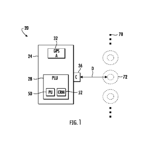
[00029] Figure 1 is a diagram schematically illustrating portions of an
example plant locating system 20. Plant locating system 20 may facilitate the
automated locating and mapping of individual plants to facilitate automated
customized care and management of the individual plants. Plant locating
system 20 comprises vehicle 24 and plant locating unit 28.
[00030] .. Vehicle 24 is configured to traverse through a region containing
plan such as a vineyard, orchard or field. In some implementations, vehicle
24 may comprise a tractor. In other implementations, vehicle 24 may
comprise other forms of a vehicle. In some implementations, vehicle 24 is
self-propelled. In other implementations, vehicle 24 is pushed or towed by
another vehicle. Vehicle 24 comprises and supports a global positioning
system (GPS) antenna 32 and a monocular camera 36.
8
CA 03233541 2024- 3- 28
WO 2023/055367 PCT/US2021/052803
[00031] GPS antenna 32 (also sometimes referred to as global
navigation satellite system (GNSS) antenna) receives and expands radio
signals sent by distinct frequencies from a GPS or GNS system. The signals
are converted into electronic signals that are used by an associated GPS
receiver to determine the geographic location, such as longitudinal and
latitudinal coordinates, of the GPS antenna.
[00032] Monocular camera 36 is mounted to or carried by vehicle 24 so
as to face in a sideways direction from vehicle 24. The term "sideways" refers
to a direction facing away from sides of vehicle 24, wherein the sides of
vehicle 24 generally extend in planes perpendicular to the straight direction
of
travel of vehicle 24 (such as when front and rear axles are parallel).
Monocular camera 36 is mounted so as to face the sides of rows of plants or
so as to face the ends of rows of plants in a vineyard, orchard or field. In
contrast to a stereo camera, a monocular camera is a single-eyed system and
generally less expensive and less complex than a stereo camera. In contrast
to a stereo camera, monocular camera 36 may lack the ability to, by itself,
detect or measure the distances of objects from the camera.
[00033] In some implementations, plant locating system 20 is configured
for locating individual plants based upon the stem of such plants. For
example, in some implementations, plant locating system 20 is configured to
locate or map the location of a stem of an individual vine. In such
implementations, monocular camera 36 is supported at a height no greater
than 110 cm above the underlying terrain or above the lowest ground
contacting point of vehicle 24. At this height, monocular camera 36 may
capture a sample image that is focused on a stem (the portion extending from
the crown at ground level to the branches) of an individual plant of interest
without the crown overly obstructing a view of the stem. In some
implementations where plant locating system 20 is configured to locate or
map other species or types of individual plants, monocular camera 36 may be
supported by vehicle 24 at other heights.
9
CA 03233541 2024- 3- 28
WO 2023/055367 PCT/US2021/052803
[00034] .. Plant locating unit 28 uses data, signals or information from
GPS antenna 32 and camera 36 to identify the geographical coordinates
(geographical location of a plant of interest). Plant locating unit 28
comprises
processing unit 50 and a non-transitory computer-readable medium 52.
Processing unit 50 follows instructions contained in medium 52.
[00035] Non-transitory computer-readable medium 52 comprise a
persistent storage device storing recorded instructions for processing unit
30.
Examples of medium 52 include, but are not limited to, solid-state memory
(flash memory), disk memory and the like. As shown by FIG. 2, medium 52
comprises sample image acquisition instructions 60, GPS antenna locating
instructions 62, image analysis instructions 64, distance determining
instructions 66 and plant locating instructions 68. Instructions 60-68 direct
processing unit 50 to carry out the example plant locating method 100
outlined in Figure 3.
[00036] As indicated by block 104 of method 100 in Figure 3, sample
image acquisition instructions 60 direct processing unit 50 to acquire a
sample
image 70 (shown in Figure 4) of a plant of interest 72 (shown in Figures 1 and
4) at a time with monocular camera 36 which is supported by vehicle 24 at an
unknown distance from the plant of interest 72. In the example illustrated,
the
plant of interest 72 (schematically illustrated) comprises a stem 74 and a
crown of branches 76. In the example illustrated, the plant of interest 72
forms part of a row 78 of other plants. In some implementations, the rows
may be made of rows of a single species or type a plant. In other instances,
the rows may comprise multiple different types or different species or
varieties
of plants. In some implementations, the different plants in row 78 may be at
different growth stages. Moreover, the different plants in row 78 may be
growing under different conditions, such as different soil types, moisture
levels
or the like.
CA 03233541 2024- 3- 28
WO 2023/055367 PCT/US2021/052803
[00037] As indicated by block 106 of method 100 in Figure 3, GPS
antenna locating instructions 62 direct processing unit 50 to determine a
geographic location estimate of the GPS antenna 32 at the time, the same
time at which the sample image was acquired. Such a determination may
involve acquiring signals from GPS antenna 32 and then extrapolating the
geographical coordinates of antenna 32. In some implementations, the
determined geographic coordinates of GPS antenna 32 may further be
transformed or translated to a base link of vehicle 24 which serves as the
origin in a coordinate system for the position of vehicle 24. In some
implementations, the base link is a center of the rear axle of vehicle 24. In
other implementations, such translation of the geographic coordinates or
location of antenna 32 may be omitted.
[00038] As indicated by block 108 of method 100 in Figure 3, image
analysis instruction 64 direct processing unit 50 to identify a selected
portion
80 of the sample image 70 comprising or encompassing the plant of interest
72. In the example illustrated, the selected portion 80 comprises a window or
closed loop that extends about particular portion of sampling error 70,
wherein
the selected portion 80 is less than the whole of sample image 70. The
selected portion 80 may be defined so as to cover, overlay, surround or
enclose particular content of sample image 70. The selected portion 80 may
be defined so as to enclose, extend over, extend within or overlay particular
predefined portions or features shown in sample image 70. In the example
illustrated, selected portion 80 is generated or defined so as to encompass
the stem 74 and a junction of stem 74 and crown 76. Although the example
selected portion 80 is shown as a generally rectangular loop enclosing the
predefined features, in other implementations, selected portion 80 may
comprise a window having other shapes and may enclose additional or other
features. In other implementations, rather than enclosing selected features,
selected portion 80 may have a size and shape that matches the size and
11
CA 03233541 2024- 3- 28
WO 2023/055367 PCT/US2021/052803
shape of the selected features. In some implementations, selected portion 80
may trace a perimeter of the selected features.
[00039] In some implementations, processing unit 50 carries out image
analysis by analyzing the number of pixels, color or shading of pixels, the
clustering of pixels and the like. In some implementations, processing unit 50
utilizes such analysis to define the size and/or shape of selected portion 80.
In some implementations, the particular predefined features that define where
selected portion 80 is located, its size and/or shape may be predefined and
programmed.
[00040] In some implementations, plant locating unit 28 to be part of a
neural network that "learns" the predefined features or criteria that define
the
location and configuration of selected portion 80 from a set of training
images,
wherein each of the training images comprise a training portion that has a
location, size and/or shape based upon features in the training image. For
example, different training images may depict the same training plant under
different lighting conditions or from different angles, wherein a selected
portion of the training image is encompassed by the training portion.
Different
training images may depict different training plants at the same or different
stages of growth and at different distances or vectors from the camera that
capture the training image, wherein a selected portion of the training image
is
encompassed by the training portion. The processing unit 50, forming part of
a neural network, learns how to generate and configure a selected portion in a
sample image from all the different training images and the human or
computer-generated training portions in each training image. The processing
unit, as part of the neural network, learns, from the training images, the
common criteria used for configuring the training portions and applies the
same criteria when configuring a selected portion 80 in a sample image 70.
[00041] As indicated by block 110 of method 100 in Figure 3, distance
determining instructions 66 direct processing unit 50 to determine a distance
12
CA 03233541 2024- 3- 28
WO 2023/055367 PCT/US2021/052803
(and possibly a direction or vector) between the plant of interest 72 and the
monocular camera 36 based upon the selected portion 80. In some
implementations, the distance (which may include the direction) is determined
by processing unit 50 evaluating characteristics of selected portion 80. Such
characteristics may include, but are not limited to, the size of selected
portion
80, the number of pixels encompassed by or forming selected portion 80
and/or, in some implementations, the shape of selected portion 80. In some
implementations, the selected portion name may have a predefined constant
shape amongst different sample images, wherein the distance and possibly
direction of the plant of interest 72 from the camera 36 is determined based
upon the size of the selected portion 80 and the number of pixels of image 70
within selected portion 80.
[00042] As indicated by block 112 of method 100 in Figure 3, plant
locating instructions 68 direct process unit 50 to determine a geographic
location estimate (an estimate of the geographic coordinates, e.g., longitude
and latitude) of the plant of interest 72 based upon both the geographic
location estimate for the GPS antenna 32 (determined in block 106) at the
time and the determined distance (and possibly the determined direction)
(determined in block 110). For example, given the determined geographic
coordinates of GPS antenna 32 at the time that the sample image 70 with
captured by camera 36, the generally fixed and known positioning of camera
36 relative to antenna 32, and the determined distance D (shown in Figure 1)
between camera 36 and the plant of interest 72, processing unit 50 may
calculate the geographic location or geographic coordinates of the plant of
interest 72.
[00043] .. In some implementations, the geographic location the plant of
interest 72 is based upon the geographic location of particular selected or
predefined portions of the plant of interest 72. For example, in circumstances
where the plant of interest 72 has a stem 74 and a crown or head 76, such as
with a vine or a tree, the geographic location of the plant of interest 72 may
be
13
CA 03233541 2024- 3- 28
WO 2023/055367 PCT/US2021/052803
based upon the geographic location of the stem 74. Stem 74 may provide a
more precise inconsistent feature for defining the geographic location of the
plant of interest 72. Crowns or heads may have differing extents and different
shapes, whereas stem 74, rising from the underlying ground, is generally
straight and provides more consistent indication of the location of the plant
of
interest 72 relative to other plants in rows 78.
[00044] As discussed above, in the example illustrated, camera 36 may
be supported at a height so as to facilitate the capture of stem 74, the basal
end of stem 74 where the stem rises from the underlying ground to where the
plant branches outwardly from the stem to form the crown 76. In such
implementations where the plant of interest 72 comprises a vine, camera 36
may be supported at a height no greater than 110 cm above the ground or
above the lowest ground contacting point of vehicle 24, wherein camera 36
faces in a general direction parallel to the ground surface and parallel to
the
axles of vehicle 24. In other implementations, camera 36 may be supported
at other heights and at other relative angles with respect to the axles of
vehicle 24.
[00045] Upon determining the geographic location or coordinates of the
plant of interest 72, plant locating unit 28 may record the geographic
location
of plant 72 for subsequent customized and automated management and care
of the plant of interest 72. When vehicle 24 or a different vehicle (ground
supported or airborne) is adjacent to the previously identified location of
the
plant of interest, based upon the location of the vehicle from GPS signals or
other locating methods for the vehicle, particular management or other
operations may be carried out on the individual plant of interest 72. For
example, the plant of interest 72 may receive customized amounts or types of
herbicide, insecticide, fertilizer, irrigation, tillage and the like. The
plant of
interest 72 may receive customized pruning, harvesting operations or the like
based upon particular characteristics of the plant of interest based upon the
particular type or species the plant of interest or as determined from other
14
CA 03233541 2024- 3- 28
WO 2023/055367 PCT/US2021/052803
data obtained regarding the plant of interest from vehicle mounted cameras,
satellite images or the like. Each individual plant in a vineyard, orchard or
field may receive a different customized treatment in an automated fashion.
[00046] In some implementations, plant locating unit 28 may
continuously determine and record the geographic coordinates or locations of
multiple plants as vehicle 24 moves or passes through the orchard, vineyard
or field. Plant locating unit 28 may use the recorded locations to form a
plant
map 84, an example of which is shown in Figure 5. The plant map 284 may
be specifically used to automatically control the navigation of vehicle 24 or
other vehicles between the plants, such as between consecutive rows 78-1
and 78-2. As noted above, the plant map 284 may be used to provide
customized and automated care and management of individual plants in each
of rows 78-1 and 78-2. Adjacent plants 72 in the same row may be
individually monitored, sensed and distinguished using data captured by
cameras or other sensors carried by vehicle 24 or acquired by other vehicles,
either ground-based or airborne. Based upon the different attributes of the
adjacent plants in the same row, the adjacent plants may receive different
treatment customized to their particular condition, species, type or stage of
growth.
[00047] In some implementations, plant locating unit 28 or other
computer systems may utilize the mapped geographic coordinates of plants
72 to identify gaps 86 in rows 78. Such gaps 86 may be the result of missed
planting or the result of the prior plant not surviving. Plant locating unit
28
may identify such a gap 86 by identifying an average or pattern of spacings
between consecutive plants 72 in a row, wherein locations where the general
pattern of plant locations is broken or where two consecutive plants are
spaced by a distance greater than a predefined threshold (such as greater
than the average spacing plus some tolerance) are determined to be a gap
86. A crop manager may be notified of the geographic location or coordinates
of each of gaps 86 such that a crop manager may carry out remedial action
CA 03233541 2024- 3- 28
WO 2023/055367 PCT/US2021/052803
such as replanting in the gap 86. In some circumstances, the crop manager
may utilize the identified gap 86 to cease or adjust the application of
herbicide, insecticide, fertilizer, water or the like at the particular gap
86.
[00048] .. As further shown by Figure 5, as vehicle 24 is moving through a
region of plants 72 and determining their individual particular geographic
coordinates or locations, vehicle 24 may be gathering additional information
regarding the surrounding orchard, vineyard or field conditions with sensors
such as cameras and the like. Plant location unit 28 may associate such
detected plant condition with those plants 72 proximate to such areas. As a
result, plant location unit 28 may further map particular areas of a field,
orchard or vineyard having particular identified conditions. In the example
illustrated, plant map 84 additionally includes or maps a wet region 88 and a
weed infested region 90. Other conditions may also be map such as soil type,
nutrient levels and the like.
[00049] Figures 6 and 7 illustrate an example of how plant locating unit
28 may additionally locate individual rows 78-1, 78-2, 78-3 and so on
(collectively referred to as rows 78) and their endpoints 92 in the example
illustrated, rows 78 comprise rows of grapevines in a vineyard, wherein the
ends of row 78 are marked with poles 94-1, 94-2, 94-3 and so on (collectively
referred to as poles 94). As shown by Figure 6, as vehicle 24 travels along
the ends 92 of such rows 78, camera 36 may capture sample images of poles
94 at particular times. At each of such particular times, the location of GPS
antenna 32 is further identified or determined.
[00050] Figure 7 illustrates an example sample image 96 taken by
camera 36 and including end row pole 94-2. As further show by Figure 7,
plant locating unit 28 may identify selected portion 98 of image 96 in a
fashion
similar to the selection of selected portion 80 in sample image 70 described
above. For example, image analysis instructions 64 may direct processing
unit 50 to identify a selected portion 98 of the sample image 96 comprising or
16
CA 03233541 2024- 3- 28
WO 2023/055367 PCT/US2021/052803
encompassing the end row pole 94-2. In the example illustrated, the selected
portion 98 comprises a window or closed loop that extends about particular
portion of sample image 96, wherein the selected portion 98 is less than the
whole of sample image 96. The selected portion may be defined based upon
the content of sample image 96 and may be defined so as to enclose, extend
over, extend within or overlay particular predefined portions or features
shown
in image 96. In the example illustrated, select portion 98 encompasses the
base and end of a pole 94-2. Although the example selected portion 98 is
shown as a generally rectangular loop enclosing the predefined features, in
other implementations, selected portion 80 may comprise a window having
other shapes and may enclose additional or other features. In other
implementations, rather than enclosing selected features, select portion 98
may have a size and shape that matches the size and shape of the selected
features. In some implementations, selected portion 98 may trace a perimeter
of the selected features.
[00051] In some implementations, processing unit 50 carries out image
analysis by analyzing the number of pixels, color or shading of pixels, the
clustering of pixels and the like to define the size and/or shape of selected
portion 98. In some implementations, the particular predefined features that
define where selected portion 98 is located, it size and/or shape may be
predefined and programmed.
[00052] In some implementations, plant locating unit 28 may be part of a
neural network that "learns" the predefined features that define the
configuration of selected portion 98 from a set of training images, wherein
each of the training images comprise a training portion that has a location,
size and/or shape based upon features in the training image. For example,
different training images may depict the same end row pole under different
lighting conditions or from different angles, wherein a selected portion of
the
training image is encompassed by the training portion. Different trainers may
depict different training and row poles at different distances or vectors from
17
CA 03233541 2024- 3- 28
WO 2023/055367 PCT/US2021/052803
the camera that capture the training image, wherein a selected portion of the
training images encompassed by the training portion. The processing unit 50,
forming part of a neural network, learns how to generate and configure a
selected portion in a sample image from all the different training images and
the human or computer-generated training portions in each training image.
The processing unit, as part of the neural network, learns, from the training
images, the common criteria used for configuring the training portions and
applies the same criteria when configuring a selected portion 98 in a sample
image 96.
[00053] Distance determining instructions 66 may direct processing unit
50 to determine a distance (and possibly a direction or vector) between the
end row pole 94 and the monocular camera 36 based upon the selected
portion 98. In some implementations, the distance (which may include the
direction) is determined by processing unit 50 evaluating characteristics of
selected portion 80. Such characteristics may include, but are not limited to,
the size of selected portion 80, the number of pixels encompassed by or
forming selected portion 98 and/or, in some implementations, the shape of
selected portion 80. In some implementations, the selected portion name
may have a predefined constant shape amongst different sample images,
wherein the distance and possibly direction of the end row pole 94-2 from the
camera 36 is determined based upon the size of the selected portion 98 in the
number of pixels of image 96 within selected portion 98.
[00054] Plant locating instructions 68 may direct process unit 50 to
determine a geographic location estimate (an estimate of the geographic
coordinates, e.g., longitude and latitude) of the end row pole 94 based upon
both the geographic location estimate for the GPS antenna 32 (determined in
block 106) at the time and the determined distance (and possibly the
determined direction) (determined in block 110). For example, given the
determined geographic coordinates of GPS antenna 32 at the time that the
sample image 96 with captured by camera 36, the generally fixed and known
18
CA 03233541 2024- 3- 28
WO 2023/055367 PCT/US2021/052803
positioning of camera 36 relative to antenna 32, and the determined distance
D2's new (shown in 1) between camera 36 and the end row pole, processing
unit may calculate the geographic location or geographic coordinates of end
row pole 94-2.
[00055] Figure 8 illustrates oceans of an example plant locating system
220. Plant locating system comprises a vehicle, in the form of a tractor 224,
and a plant locating unit 228. Tractor 224 comprises a GPS antenna 232 and
a monocular camera 236. GPS antenna 232 is similar to GPS antenna 32
described above. GPS antenna 232 is mounted or supported on the roof 300
of tractor 224. Roof 300 is supported above a seat 302 to form a cab region
304.
[00056] Monocular camera 236 is similar to monocular camera 36
described above. Monocular camera 236 is incorporated into a front left
corner post 306 of tractor 224 and faces in a sideways direction generally
parallel to the rotational axes of the rear tires 308. Monocular camera 236
extends at a height no greater than 110 cm above the lowest ground
contacting point 310 of tractor 224, the bottom of tires 308. As a result,
monocular camera 236 is well-suited for capturing the stems of plants, along
the sides of tractor 224, that are to be located or mapped.
[00057] Plant locating unit 228 is similar to plant locating unit 28
described above. Plant locating unit 228 includes non-transitory computer-
readable medium 52 with instructions 60-68 described above for carrying out
method 100 (shown in Figure 3). In the example illustrated, plant locating
unit
228 is part of a neural network, wherein plant locating unit 228 has "learned¨
the predefined features that define the configuration of selected portion 80
from a set of training images, wherein each of the training images comprise a
training portion that has a location, size and/or shape based upon features in
the training image.
19
CA 03233541 2024- 3- 28
WO 2023/055367 PCT/US2021/052803
[00058] As schematically shown by plant locating unit 228 may utilize a
set 260 of training images 262, 264. Different individual training images 262
may depict the same training plant 263 under different lighting conditions or
from different angles, wherein a selected portion of the training image is
encompassed by the training portion 266. Different individual training images
264 may depict different training plants 263 at the same or different stages
of
growth and at different distances or vectors from the camera 236 that capture
the training image 262, 264, wherein a selected portion of the training image
is encompassed by the training portion 266. The processing unit 50, forming
part of a neural network, learns how to generate and configure a selected
portion 80 in a sample image 70 from all the different training images 262,
264
and the human or computer-generated training portions 266 in each training
image 262, 264. The processing unit, as part of the neural network, learns,
from the training images, the common criteria used for configuring the
training
portions and applies the same criteria when configuring a selected portion 80
in a sample image 70 (shown in Figure 4).
[00059] As further shown by Figure 8, once plant locating unit 228 has
carried out method 100 and has determined the geographic location estimate
or geographic coordinates for the particular plant of interest, and other
plants
of interest, plant locating unit 228 may generate and record plant map 84
(described above).
[00060] As also described above with respect to Figures 6 and 7, plant
locating unit 228 may additionally carry out method 100 to locate and map
end row poles 94. Figure 8 schematically illustrates an example set 360 of
end row pole training images 362, 363. Different individual training images
362 may depict the same end row pole 363 under different lighting conditions
or from different angles, wherein a selected portion of the training image is
encompassed by the training portion 366. Different individual training images
364 may depict different end row poles at different distances or vectors from
the camera 236 that capture the training image 362, 364, wherein a selected
portion of the training image is encompassed by the training portion 366. The
CA 03233541 2024- 3- 28
WO 2023/055367 PCT/US2021/052803
processing unit 50, forming part of a neural network, learns how to generate
and configure a selected portion 98 in a sample image 96 from all the
different
training images 362, 364 and the human or computer-generated training
portions 366 in each training image 362, 364. The processing unit, as part of
the neural network, learns, from the training images, the common criteria used
for configuring the training portions and applies the same criteria when
configuring a selected portion 98 in a sample image 96 (shown in Figure 7).
[00061] In the example illustrated, plant locating unit 228 is carried by
the vehicle in the form of tractor 224. The sets 260 and 360 of training
images 262, 264, and 362, 364, respectively, are also carried by the vehicle
in
the form of tractor 224. In other implementations, one or both of sets 260 and
360 may be located or stored remote from tractor 224, wherein such sets 260
and/or 360 are accessible by plant locating unit 228 in a wireless fashion.
For
example, sets 260 and/or 360 may be stored in a cloud, wherein access is
provided by a server. In such implementations, sets 260 and/or 360 may be
shared or made available to multiple different vehicles or multiple different
tractors 224 at different locations.
[00062] .. In some implementations, plant locating unit 228 is remote from
tractor 224. In such implementations, the location of GPS antenna 232 at
individual times and the corresponding sample images captured by camera
236 may be transmitted to the remote plant locating unit 228 in a wireless
fashion. In such implementations, the remote location may be provided with
enhanced bandwidth and computing capabilities and may carry out plant
locating for fleets of different tractors 224 traversing multiple different
orchards, fields or vineyards. In some implementations, different portions of
plant locating unit 228 may be distributed between first portions carried by
the
vehicle in the form of tractor 224 and second portions remote from the vehicle
in the form of tractor 224. In such implementations, those second portions
may be in wireless communication with the vehicle in the form of tractor 224.
[00063] For example, in some implementations, the geographic location
estimate of the GPS antenna 232 may be locally determined by a processor
21
CA 03233541 2024- 3- 28
WO 2023/055367 PCT/US2021/052803
carried by tractor 224, wherein the identification of the selected portion of
the
sample image comprising the plant of interest is carried out by a processing
unit remote from tractor 224. In such an implementation, the neural network
that carries out such identification may be located remote from tractor 224
and
may share its capabilities with a fleet of different tractors 224. In such an
example implementation the determination of the distance between the plant
of interest in the monocular camera and the determination of the geographic
location of the plant of interest based on the geographic location estimate of
the GPS antenna at the time and the determined distance may be carried out
by the processing unit carried by the tractor 224. In other implementations,
the different steps identified in blocks 104-112 for locating a plant may
carried
out by processing units (and associated computer-readable mediums) having
other distributions between tractor 224 and remote locations which are in
wireless communication with tractor 224. Likewise, the different steps in
blocks 104-112, as modified to locate end row poles as described above with
respect to Figures 6 and 7, may be distributed in various fashions amongst
processing units and computer-readable mediums carried by tractor 224 and
other processing units and associated computer-readable mediums remote
from tractor 224 and in wireless communication with tractor 224.
[00064] Figure 9 is a left front perspective view of plant locating system
220 and tractor 224 asked tractor 224 is traveling through a field, orchard or
vineyard 202 including rows 78-1, 78-2, 78-3 and 78-4 of plants. As shown by
Figure 9, tractor 224 may be provided with a second monocular camera 236'
on the other side of tractor 224. Camera 236' may be supported at the same
height and by the same structure as monocular camera 236 on the left side of
tractor 224. Cameras 236 and 236' facilitate the concurrent capturing of
sample images 70 of plants of interest 72 arranged in two different rows on
opposite sides of tractor 224. As a result, plant locating unit 228 may
concurrently locate or determine the geographic coordinates of plants of
interest 72 in two different rows 78 on opposite sides of tractor 224 as
tractor
22
CA 03233541 2024- 3- 28
WO 2023/055367 PCT/US2021/052803
224 travels along in between the consecutive rows 78. As a result, the
mapping of different individual plants may be carried out in a timelier
manner.
[00065] In some implementations, individual sample images captured by
monocular cameras 236 and 236'may include multiple plants of interest in a
first row of plants and multiple plans of interest in a second row of plants
more
distant from tractor 224 than the first row of plants. In such
implementations,
plant locating unit 228 may identify multiple selected portions 80 in the
sample
image, each selected portion 80 being associated with a different plant of
interest 72. For each of the different selected portions 80 in the individual
sample image 70, plant locating unit 228 may determine a distance between
the particular plant of interest in the monocular camera based upon
characteristics of the particular selected portion 80. Based upon the
geographic location estimate of the GPS antenna at the time the sample
image was captured by camera 236 or 236' and the determined distances
between the monocular camera 236 or 236'in the particular plant of interest
72, plant locating unit 228 may concurrently determine the geographic
coordinates or concurrently locate multiple different plants of interest in
the
same row or in multiple different rows from the single sample image, further
enhancing the rate at which plants in a field, orchard or vineyard may be
geographically located and mapped.
[00066] Figure 10 illustrates an example training image 462, an example
of a training image that may be part of set 260. Training image 462 depicts a
training vine 463 having a stem 374 and a crown 376. Figure 10 further
illustrates an example training portion 466 which has been defined by a
human based upon characteristics of the training plant 463. The training
portion 466 has been defined so as to enclose the basil end of stem 474 and
a juncture of stem 474 with crown 476. As described above with respect to
system 220, set 260 may comprise a multitude of such sample images 462,
wherein different sample images 462 may be taken or captured at different
distances, with different lighting conditions, and with different plants
having
different sizes, stages of growth and the like.
23
CA 03233541 2024- 3- 28
WO 2023/055367 PCT/US2021/052803
[00067] __ Figure 11 illustrates an example sample image 570 captured by
camera 236 of tractor 224. Sample image 570 depicts multiple plants of
interest 72 in multiple different rows on one side of tractor 224. Figure 11
further illustrates multiple selected portions 80-1, 80-2, 80-3, 80-4 and so
on
(collectively referred to as selected portions 80) in the same individual
sample
image 570 and surrounding the multiple different plants of interest 72.
Selected portions 80 are identified by plant locating unit 228. In the example
illustrated, plant locating unit 228 may utilize the GPS location of the GPS
antenna 232 of tractor 224, the known relative positioning of GPS antenna to
232 and monocular camera 236, and analyzed characteristics of each
selected portion 80 (such as the size of each selected portion 80 as well as
the number of pixels contained within each selected portion 80) to determine
the individual geographic locations or coordinates of each of the plants of
interest 72 depicted in image 570 and having portions within an associated
selected portion 80.
[00068] __ As shown by Figure 11, sample image 570 includes multiple
identified selected portions 80 of different plants of interest in different
rows.
During a first pass of tractor 224 along a first side of a row, a first sample
image of a plant of interest may be captured by a camera 236, 236' and used,
as described above with respect to method 100, to determine a first estimate
for the geographic location, the coordinates of the plant of interest. During
a
second pass of tractor 224 along a second side of the row, opposite the first
side, a second sample image of the plant of interest may be captured and
used, as described above with respect to method 100, to determine a second
estimate for the geographic location, the coordinates of the plant of
interest.
In some implementations, the first and second sample images may be
captured using the same monocular camera 236, 236', wherein the first and
second sample images are captured while the vehicle is moving in opposite
directions. In some implementations, the first sample image may be captured
using monocular camera 236 while the tractor 224 is moving in a first
direction
24
CA 03233541 2024- 3- 28
WO 2023/055367 PCT/US2021/052803
and the second sample image may be captured using the same monocular
camera 236 while the tractor 224 is moving in a second opposite direction.
[00069] In such implementations, plant locating unit 228 may determine
a third estimate for the geographic location of the plant of interest based
upon
a combination of the first estimate and the second estimate. For example,
plant locating unit 228 may assign the plant of interest with a longitudinal
coordinate that is the average of the longitudinal coordinates of the first
and
second estimates and a latitude coordinate that is the average of the
latitudinal coordinates of the first and second estimates. In yet other
implementations, other combinatorial techniques or statistical techniques may
be used to use both of the first and second estimates to determine a third
estimate for the geographic location of the plant of interest. In some
implementations, greater than two separate sample images and greater than
two geographic location estimates for a particular plant of interest may be
used or combined to determine the final geographic location estimate for the
plant of interest.
[00070] .. In some implementations plant locating system 220 may capture
a first sample image of a plant of interest when tractor 224 is moving along
or
positioned between a first pair of rows of plants, wherein the first sample
image is captured while the plant of interest is on a side of tractor 224,
while
the monocular camera 236, 236' used to capture the first sample image faces
in a first direction. Using the first sample image, plant locating unit 228
may
carry out method 100 to determine a first geographic location estimate for the
plant of interest. During another pass of tractor 224 along or positioned
between a second pair of rows of plants, the same camera 236, 236' may
capture a second sample image of the same plant of interest while the plant of
interest is on the same side of tractor 224, while the monocular camera 236,
236' used to capture the second sample image faces in the same first
direction. The particular plant of interest may be farther away from camera
236, 236' in the second sample image as compared to the first sample image.
Using the second sample image, plant locating unit 228 may carry out method
CA 03233541 2024- 3- 28
WO 2023/055367 PCT/US2021/052803
1 00 to determine a second geographic location estimate for the same plant of
interest.
[00071] In such implementations, plant locating unit 228 may determine
a third estimate for the geographic location of the plant of interest based
upon
a combination of the first estimate and the second estimate. For example,
plant locating unit 228 may assign the plant of interest with a longitudinal
coordinate that is the average of the longitudinal coordinates of the first
and
second estimates and a latitude coordinate that is the average of the
latitudinal coordinates of the first and second estimates. In yet other
implementations, other combinatorial techniques or statistical techniques may
be used to use both of the first and second estimates to determine a third
estimate for the geographic location of the plant of interest. In some
implementations, greater than two separate sample images and greater than
two geographic location estimates for a particular plant of interest may be
used or combined to determine the final geographic location estimate for the
plant of interest.
[00072] Figure 12 illustrates an example sample image 596 captured by
camera 236 of tractor 224. Sample image 596 depicts multiple end row poles
94-1, 94-2, 94-3, 94-4, 94-5 (collectively referred to as poles 94). Figure 11
further illustrates multiple selected portions 98 -1, 98-2, 98-3, 98-4 and 98-
5
(collectively referred to as selected portions 98) in the same individual
sample
image 596 and surrounding the multiple different poles 94. Selected portions
98 are identified by plant locating unit 228. In the example illustrated,
plant
locating unit 228 may utilize the GPS location of the GPS antenna 232 of
tractor 224, the known relative positioning of GPS antenna to 232 and
monocular camera 236, and analyzed characteristics of each selected portion
80 (such as the size of each selected portion 98 as well as the number of
pixels contained within each selected portion 98) to determine the individual
geographic locations or coordinates of each of the poles 94 depicted in image
596 and having portions within an associated selected portion 98, further
26
CA 03233541 2024- 3- 28
WO 2023/055367 PCT/US2021/052803
enhancing the rate at which the ends of rows in a field, orchard or vineyard
may be geographically located and mapped.
[00073] Figure 13 is a perspective view of an example plant locating
system 620. Plant locating system 620 assembly plant locating system 220
except that camera 236 of tractor 224 is supported at a lower location on
tractor 224. In the example illustrated, monocular camera 236 is supported at
the lower end of column or post 306. In the example shown in Figure 13,
monocular camera 236 faces in a sideways or transverse direction generally
parallel to the rotational axis of rear tires 308. The monocular camera shown
in Figure 13 is located between rear wheel 308 and front wheel 309 and
below the top of front wheel 309, proximate the bottom of the chassis 311 of
tractor 224. This lower relative positioning of camera 236 may facilitate the
capturing of sample images that may better depict particular portions of the
plant or multiple plants of interest. For example, this lower relative
positioning
a camera 236 (as to camera 236 in Figure 8) may facilitate the capturing of
the stem 74 of smaller plants of interest having a lower relative height. Both
remain components of plant locating system 620 which correspond to
components of plant locating system 220 are numbered similarly.
[00074] Although the claims of the present disclosure are generally
directed to a plant and vehicle locating systems, mediums and methods, the
present disclosure is additionally directed to the features set forth in the
following definitions.
1. A plant locating system comprising:
a vehicle supporting a Global Positioning System
(GPS) antenna and a monocular camera facing in a
sideways direction from the vehicle;
a plant locating unit comprising:
a processing unit; and
a non-transitory computer-readable medium
containing instructions to direct the processing unit
to:
27
CA 03233541 2024- 3- 28
WO 2023/055367
PCT/US2021/052803
acquire a sample image of a plant of
interest captured at a time with the
monocular camera at an unknown distance
from the plant of interest;
determine a geographic location
estimate of the GPS antenna at the time;
identify a selected portion of the
sample image comprising the plant of
interest;
determine a distance between the
plant of interest and the monocular camera
based upon the selected portion; and
determine a geographic location
estimate of the plant of interest based on
the geographic location estimate of the GPS
antenna at the time and the determined
distance between the monocular camera
and the plant of interest.
2. The plant locating system of definition 1 further comprising a set
of training images comprising images captured by the
monocular camera, each of the training images comprising a
training portion, wherein the processing unit identifies the
selected portion of the sample image based upon the training
portion of each of the training images.
3. The plant locating system of definition 2, wherein the training
portion of each of the training images and the selected portion of
the sample image each comprise a window.
4. The plant locating system of definition 3, wherein the training
portion of each of the training images is human defined.
5. The plant locating system of definition 1, wherein the selected
portion comprises a window.
28
CA 03233541 2024- 3- 28
WO 2023/055367
PCT/US2021/052803
6. The plant locating system of definition 5, wherein the distance
between the plant of interest and the monocular camera is
based upon a size of the window and a number of image pixels
within the window.
7. The plant locating system of definition 5, wherein the window
encloses a portion of the plant, the training window extending
from a basal end of a stem of the plant to where the plant
branches outwardly from the stem.
8. The plant locating system of definition 1, wherein the distance
between the plant of interest and the monocular camera is
based upon a size of the selected portion and a number of
image pixels within the selected portion.
9. The plant locating system of definition 1, wherein the processing
unit and the non-transitory computer-readable medium form a
neural network that learns how to identify the selected portion of
the sample image comprising the plant of interest from a
corresponding training portion in each image of a training set of
images of plants captured by the monocular camera.
10. The plant locating system of definition 1, wherein the monocular
camera is supported on a first side of the vehicle and wherein
the vehicle supports a second monocular camera on a second
side of the vehicle facing a sideways direction from the vehicle.
11. The plant locating system of definition 1, wherein the plant
locating unit is carried by the vehicle.
12. The plant locating system of definition 1, wherein the plant
locating unit is remote from the vehicle and in wireless
communication with the vehicle.
13. The plant locating system of definition 1, wherein the plant
locating unit is distributed between first portions carried by the
vehicle and second portions remote from the vehicle and in
wireless communication with the vehicle.
29
CA 03233541 2024- 3- 28
WO 2023/055367
PCT/US2021/052803
14. The plant locating system of definition 9, wherein the set of
training images are stored in a database remote from the vehicle
and accessible by the processing unit of the vehicle and a
second processing unit of a second vehicle that is to use the set
of training images to determine a geographic location estimate
of a second plant of interest.
15. The plant locating system of definition 1, wherein the
instructions are to direct the processing unit to determine a
second geographic location estimate of a second plant of
interest and to form a map comprising the geographic location
estimate of the plant of interest and the second geographic
location estimate of the second plant of interest.
16. The plant locating system of definition 1, wherein the
instructions are to direct the processing unit to determine a
geographic location estimate of a center of a rear axle of the
vehicle at the time based upon the geographic location estimate
of the GPS antenna at the time and wherein the instructions are
to direct the processing unit to determine the geographic
location estimate of the plant of interest based on the
geographic estimate location of the center of the rear axle at the
time, the positioning of the center of the rear axle relative to the
monocular camera and the determined distance of the
monocular camera from the plant in the sample image.
17. The plant locating of definition 1, wherein the plant of interest is
in a first row of plants, wherein sample image comprises depicts
the plant of interest and a second plant of interest in a second
row of plants and wherein the instructions are to direct the
processing unit to:
identify a second selected portion of the sample image
comprising the second plant of interest;
CA 03233541 2024- 3- 28
WO 2023/055367
PCT/US2021/052803
determine a distance between the second plant of
interest and the monocular camera based upon the second
selected portion; and
determine a geographic location estimate of the second
plant of interest based on the geographic location estimate of
the GPS antenna at the time and the determined distance
between the monocular camera and the second plant of interest.
18. The plant locating system of definition 1, wherein the
instructions are to direct the processing unit to:
acquire a second sample image of the plant of interest captured at a
second time with the monocular camera at an unknown distance from the
plant of interest;
determine a second geographic location estimate of the GPS antenna
at the second time;
identify a selected portion of the second sample image comprising the
plant of interest;
determine a second distance between the plant of interest and the
monocular camera based upon the second selected portion; and
determine a second geographic location estimate of the plant of
interest based on the geographic location estimate of the GPS antenna at the
second time and the determined distance between the monocular camera and
the plant of interest; and
determine a third geographic location estimate of the plant of interest
based upon a combination of the geographic location estimate of the plant of
interest and the second geographic location estimate of the plant of interest.
19. The plant locating system of definition 18, wherein the sample
image of the plant of interest is captured with the monocular
camera while the vehicle is positioned between a first pair of
plant rows and wherein the second sample image of the plant of
interest is captured with the monocular camera while the vehicle
is positioned between a second pair of plant rows.
31
CA 03233541 2024- 3- 28
WO 2023/055367
PCT/US2021/052803
20. The plant locating system of definition 19, wherein the sample
image and the second sample image are both captured by the
monocular camera while the monocular camera is facing in a
same direction.
21. The plant locating system of definition 19, wherein the sample
image is captured by the monocular camera while the vehicle is
facing in a first direction and wherein the second sample image
is captured by the monocular camera while the vehicle is facing
in a second direction opposite the first direction.
22. The plant locating system of definition 1, wherein the monocular
camera is vertically spaced above lowermost ground engaging
portions of the vehicle by distance of no greater than 110 cm.
23. The plant locating system of definition 1, wherein the
instructions are to direct the processing unit to identify the plant
of interest as forming an end of a row of plants and wherein the
geographic location estimate for the plant of interest is identified
by the processing unit as a geographic location estimate for the
end of the row of plants.
24. The plant locating system of definition 1, wherein the
instructions are to direct the processing unit to:
acquire a second sample image of a second plant of interest
captured at a second time with the monocular camera at an unknown
distance from the plant of interest, wherein the plant of interest of the
second plant of interest are part of a row of plants;
determine a second geographic location estimate of the GPS
antenna at the second time;
identify a second selected portion of a second sample image
comprising the second plant of interest;
32
CA 03233541 2024- 3- 28
WO 2023/055367
PCT/US2021/052803
determine a distance between the second plant of interest and
the monocular camera based upon the second selected portion;
determine a second geographic location estimate of the second
plant of interest based on the geographic location estimate of the GPS
antenna at the second time and the determined distance between the
monocular camera and the second plant of interest; and
determine existence of a plant omission between the plant of
interest and of the second plant of interest based on the geographic
location estimate of the plant of interest and the second geographic
location estimate of the second plant of interest.
25. The plant locating system of definition 24, wherein the
instructions are to direct the processing unit to form a map
comprising the geographic location estimate for the plant of
interest, the second geographic location estimate for the second
plant of interest and a third geographic location for the plant
omission.
26. The plant locating system of definition 1, wherein the geographic
location estimate for the plant of interest is a geographic location
estimate for a stem of the plant of interest.
27. The plant locating system of definition 1, wherein the
instructions are to direct the processing unit to output control
signals to position the vehicle relative to the plant of interest
based upon the geographic location estimate for the plant of
interest.
28. The plant locating system of definition 1, wherein the
instructions are to direct the processing unit to output control
signals to carry out an operation on the plant of interest based
upon the geographic location estimate for the plant of interest.
33
CA 03233541 2024- 3- 28
WO 2023/055367
PCT/US2021/052803
29. The plant locating system of definition 1, wherein the
instructions are to direct the processing unit to form an
evaluation of the plant of interest and to associate the evaluation
with the geographic location estimate for the plant of interest.
30. The plant locating system of definition 1, wherein the
instructions are to direct processing unit to form a plant
management plan for the plant of interest based upon the
geographic location estimate for the plant of interest.
31. A non-transitory computer-readable medium containing
instructions to direct a processing unit, the instructions
comprising:
sample image acquisition instructions to acquire a sample
image of a plant of interest captured at a time with a monocular
camera at an unknown distance from the plant of interest;
GPS antenna locating instructions to determine a
geographic location estimate of a GPS antenna at the time;
image analysis instructions to identify a selected portion
of the sample image comprising the plant of interest;
distance determining instructions to identify a distance
between the monocular camera and the plant of interest based
upon the selected portion; and
plant locating instructions to determine a geographic
location estimate of the plant of interest based on the
geographic location estimate of the GPS antenna at the time
and the determined distance between the monocular camera
and the plant of interest.
32. A method comprising:
acquiring a sample image of a plant of interest captured
at a time with a monocular camera supported by vehicle at an
unknown distance from a plant of interest;
34
CA 03233541 2024- 3- 28
WO 2023/055367
PCT/US2021/052803
determining a geographic location estimate of the GPS
antenna at the time;
identifying a selected portion of the sample image
comprising the plant of interest;
determining a distance between the plant of interest and
the monocular camera based upon the selected portion; and
determining a geographic location estimate of the plant of
interest based on the geographic location estimate of the GPS
antenna at the time and the determined distance.
33. The method of definition 32, further comprising forming a map
comprising the geographic location estimate for the plant of
interest and a second geographic location for a plant omission.
34. The method of definition 32, wherein the geographic location
estimate for the plant of interest is a geographic location
estimate for a stem of the plant of interest.
35. The method of definition 32 further comprising outputting control
signals to position the vehicle relative to the plant of interest
based upon the geographic location estimate for the plant of
interest.
36. The method of definition 32 further comprising outputting control
signals to carry out an operation on the plant of interest based
upon the geographic location estimate for the plant of interest.
37. The method of definition 32 further comprising forming an
evaluation of the plant of interest and to associate the evaluation
with the geographic location estimate for the plant of interest.
38. The method of definition 32 further comprising forming a plant
management plan for the plant of interest based upon the
geographic location estimate for the plant of interest.
39. The method of definition 32 further comprising:
acquiring a second sample image at a second time with the
monocular camera;
CA 03233541 2024- 3- 28
WO 2023/055367
PCT/US2021/052803
determining a second geographic location estimate of the GPS
antenna at the second time;
identifying a second selected portion of the second
sample image comprising a second plant of interest;
determining a distance between the second plant of
interest and the monocular camera based upon the second
selected portion;
determining a second geographic location estimate for
the second plant of interest based on the geographic location
estimate of the GPS antenna at the second time and the second
selected portion of the second sample image; and
determining existence of a plant omission between the
plant of interest and of the second plant of interest based on the
geographic location estimate of the plant of interest and the
second geographic location estimate of the second plant of
interest.
40. The method of definition 32 further comprising:
acquiring a second sample image of the plant of interest
captured at a second time with the monocular camera at an unknown
distance from the plant of interest;
determining a second geographic location estimate of the GPS
antenna at the second time;
identifying a second selected portion of the second sample
image comprising the plant of interest;
determining a second distance between the plant of interest and
the monocular camera based upon the second selected portion;
determining a second geographic location estimate for the plant
of interest based on the geographic location estimate of the GPS
36
CA 03233541 2024- 3- 28
WO 2023/055367
PCT/US2021/052803
antenna at the second time and the determined second distance
between the plant of interest and the monocular camera; and
determining a third geographic location estimate of the plant of
interest based upon a combination of the geographic location estimate
of the plant of interest and the second geographic location estimate of
the plant of interest.
41. The method of definition 40, wherein the sample image of the
plant of interest is captured with the monocular camera while the
vehicle is positioned between a first pair of plant rows and
wherein the second sample image of the plant of interest is
captured with the monocular camera while the vehicle is
positioned between a second pair of plant rows.
42. The method of definition 40, wherein the sample image and the
second sample image are both captured by the monocular
camera while the monocular camera is facing in a same
direction.
43. The method of definition 40, wherein the sample image is
captured by the monocular camera while the vehicle is facing in
a first direction and wherein the second sample image is
captured by the monocular camera while the vehicle is facing in
a second direction opposite the first direction.
44. The method of definition 32, wherein the monocular camera is
vertically spaced above lowermost ground engaging portions of
the vehicle by distance of no greater than 110 mm.
45. The method of definition 32 further comprising:
identifying the plant of interest as forming an end of a row of
plants; and
identifying geographic location estimate for the plant of interest
as a geographic location estimate for the end of the row of plants.
37
CA 03233541 2024- 3- 28
WO 2023/055367
PCT/US2021/052803
46. The method of definition 32, wherein the vehicle comprises a
tractor and wherein the plant of interest is part of a row of plants.
47. The method of definition 32, wherein the selected portion
comprises a window.
48. The method of definition 47, wherein the distance between the
plant of interest and the monocular camera is based upon a size
of the window and a number of image pixels within the window.
49. The method of definition 48, wherein the window encloses a
portion of the plant, the window extending from a basal end of a
stem of the plant to where the plant branches outwardly from the
stem.
50. The method of definition 32, wherein the identifying of the
selected portion of the sample image is performed by a neural
network based upon a corresponding training portion in each
image of a training set of images of plants captured by the
monocular camera.
51. The method of definition 50, wherein the set of training images
are stored in a database remote from the vehicle and accessible
by a processing unit of the vehicle and a second processing unit
of a second vehicle that is to use the set of training images to
determine a geographic location estimate of a second plant of
interest.
52. The method of definition 32 further comprising determining a
second geographic location estimate of a second plant of
interest and to form a map comprising the geographic location
estimate of the plant of interest and the second geographic
location estimate of the second plant of interest.
53. The method of definition 32 further comprising:
38
CA 03233541 2024- 3- 28
WO 2023/055367
PCT/US2021/052803
determining a geographic location estimate of a center of a rear
axle of the vehicle at the time based upon the geographic location
estimate of the GPS antenna at the time; and
determining the geographic location estimate of the plant of
interest based on the geographic estimate location of the center of the
rear axle at the time, a positioning of the center of the rear axle relative
to the monocular camera and the measured distance of the monocular
camera from the plant in the sample image.
54. A vehicle locating system comprising:
a vehicle supporting a camera;
a vehicle locating unit comprising:
a processing unit; and
a non-transitory computer-readable medium
containing instructions to direct the processing unit
to:
acquire at least one image of a plant
captured by the camera and having a geographic
position estimate; and
determine a geographic location
estimate of the vehicle based on the
geographic position estimate of the plant.
55. A method comprising:
acquiring at least one image of a plant
having a geographic position estimate, the at least
one image being captured at a time by a camera
carried by a vehicle; and
39
CA 03233541 2024- 3- 28
WO 2023/055367 PCT/US2021/052803
determining a geographic location estimate
of the vehicle for the time based on the geographic
position estimate of the plant.
[00075] Although each of the above examples is described in the context
of locating and potentially mapping geographic locations of individual crop
plants for customized management, in other implementations, the same
methods and apparatus may likewise be used to locate and potentially map
the geographic locations of non-crop plants and/or non-plant structures in a
field, vineyard orchard. For example, the methods and apparatus may
likewise be used to determine the geographic locations of weeds or groups of
weeds in a field, vineyard or orchard. The methods and apparatus may
likewise be used utilized to determine the geographic locations of
obstructions
or obstacles, such as rocks or the like in a field, vineyard or orchard. The
potentially stored or mapped geographic locations of weeds may be used to
specifically address such weeds through the application of herbicides,
cultivation/tillage or subsequent planting decisions. The potentially stored
or
mapped geographic patient obstruction may be used to address such
obstructions by controlling the positioning of an implement to avoid damage to
the implant from the obstruction or to locate and subsequently remove the
obstruction.
[00076] .. Although the present disclosure has been described with
reference to example implementations, workers skilled in the art will
recognize
that changes may be made in form and detail without departing from the
scope of the claimed subject matter. For example, although different example
implementations may have been described as including features providing
benefits, it is contemplated that the described features may be interchanged
with one another or alternatively be combined with one another in the
described example implementations or in other alternative implementations.
Because the technology of the present disclosure is relatively complex, not
all
changes in the technology are foreseeable. The present disclosure described
with reference to the example implementations and set forth in the following
CA 03233541 2024- 3- 28
WO 2023/055367
PCT/US2021/052803
claims is manifestly intended to be as broad as possible. For example, unless
specifically otherwise noted, the claims reciting a single particular element
also encompass a plurality of such particular elements. The terms "first",
"second", "third" and so on in the claims merely distinguish different
elements
and, unless otherwise stated, are not to be specifically associated with a
particular order or particular numbering of elements in the disclosure.
41
CA 03233541 2024- 3- 28