Note: Descriptions are shown in the official language in which they were submitted.
WO 2023/098977
PCT/EP2021/083581
-1-
NETWORK-ASSISTED SELF-POSITIONING OF A MOBILE COMMUNICATION
DEVICE
BACKGROUND
The present invention relates to technology that enables a mobile
communication device
to obtain information indicative of its location and more particularly to
technology that utilizes
guidance from a network node when sensing a local area to determine a position
of a mobile
communication device.
There is a growing need for applications in modem-equipped devices to be aware
of their
own geographic positions ("self-position") with high accuracy. There are
several radio-based
positioning technologies related to cellular communication as well as
Bluetooth-compliant
technology providing the positioning accuracy of a few meters (better under
certain conditions).
In US Patent Publication No. US20170307746A1 (published in 2017), a vehicle
compares a
radar map with a reference data map to localize itself. In US Patent
Publication No.
US20190171224A1 (published 2019) a vehicle creates a map of its environment in
a first step
and then uses the environment features and stationary reflections to localize
itself; non-stationary
objects are identified so as to not cause location errors. The referenced
patent document
mentions that relative velocity (self-movement) can be derived based on direct
measurements of
the radial speeds of reflection points from stationary objects, measured
relative to the observer.
This also allows determination of rotation when using multiple spatial
distributed radar sensors.
Deterministic and stochastic radar responses are used in Liu et al., A Radar-
Based Simultaneous
Localization and Mapping Paradigm for Scattering Map Modeling, IEEE Asia-
Pacific
Conference on Antennas and Propagation (APCAP), Auckland, New Zealand (2018),
to build a
map of the environment and localize the radar. US Patent Publication No.
US20200233280A1
discloses a method for determining the position of a vehicle by matching radar
detection points
with a predefined navigation map which comprising elements representing static
landmarks
around the vehicle. The publication also mentions -the navigation map can be
derived from a
global database on the basis of a given position of the vehicle, e.g. from a
global position system
of the vehicle." The approach described in Marck et al., "Indoor Radar SLAM A
Radar
Application For Vision And GP S Denied Environments", European Microwave
Conference,
Nuremberg, Germany (2013) involves feeding the radar image into a mapping and
localization
algorithm and using an iterative closest point algorithm to determine the
radar location and
movement, whereas a particle filter optimizes measurement performance. As
shown in Marck et
CA 03239627 2024- 5- 29
WO 2023/098977
PCT/EP2021/083581
-2-
al., radar-based Simultaneous Localization and Mapping (SLAM) generally
requires 360 degrees
panoramic high-resolution range information which can be achieved by either a
radar apparatus
with rotating antenna or an electronically scanned phased array radar.
In another disclosure, US Patent Publication No. US20200256977A1 (published
2020)
describes a vehicle using at least one radar sensor to generate a map of the
environment and then
comparing its current measurement with the generated map to localize itself.
As similarly
disclosed in US Patent Publication No. US20200232801A1, a vehicle uses radar
to create a local
map and then retrieves a map of the environment and correlates the two to
localize itself. And as
described in US Patent Publication No. US20190384318A1, a device uses a radar
signal to
create a local grid map and compares this with a map stored in the device's
memory to localize
itself.
Other sensor options for localization include the use of cameras where
techniques such as
SLAM can support a more accurate relative position. Information from different
sensors may be
combined in so-called sensor fusion. Using radar-based SLAM, a device can map
an unknown
environment and localize itself in the environment.
There are a number of problems associated with conventional positioning
technology.
For example, radio-based positioning that relies exclusively on the
communication between one
or a few base stations or anchor points and a device produces results that are
accurate only down
to within a few meters unless a large number of anchor transmitters are
provided, the clock
synchronization is extremely accurate, or certain assumptions can be made on
the environment or
relative position. Such systems scale poorly with respect to accuracy (not
consistent, from at best
around 2 meters but sometimes several meters) and cost Furthermore, the
positions of the base
stations or access points also need to be very accurately known, which adds to
installation cost
and can cause problems if these are moved later on.
As the deployment of indoor base stations foremost aims to cater to coverage
of
communication services, it is very likely that there could be significant gaps
in coverage of the
areas that can obtain an accurate enough position. In some cases it might even
lead to zones and
spots where conventional positioning technology works poorly (even though, in
some cases,
communication may still be possible).
An alternative approach, sensor fusion, which combines sensor data from SLAM
with,
for example, data derived from radio-based positioning, GPS, and/or cameras,
and inertial
measurement units (IMUs) for movement changes, can lead to high accuracy, but
demands
CA 03239627 2024- 5- 29
WO 2023/098977
PCT/EP2021/083581
-3-
multiple sensors which adds significant complexity, cost, printed circuit
board (PCB) area, and
device size.
And regardless, conventional radar self-location methods may not work at all,
or at best
are unable to guarantee high precision in certain scenarios, such as when a
device is located in
(or moving along) a long corridor where there is no clear landmark structure
for the device to
detect and determine distance, and in which the structures and distances
located within short
range are constant as the device is moved.
Another problematic situation arises when the device is located in a very
large room,
where the relevant objects are very far away. In such a situation, the device
may be able to detect
structures via radar but their distance results in lower sensing accuracy
compared to when
structures located quite close to the device's position. In principle,
structures in the ceiling can be
used as sensing landmarks by directing the radar upwards, but most often there
is a panel which
gives a very flat surface with little distinctive structural features. It is
difficult for typical radar
sensing to reveal structures from behind such a ceiling panel.
Another scenario that poses self-positioning difficulties arises in open areas
primarily
dominated by moving people and/or objects that may lie in the way of
conventional radar signals
and consequently hide static reference objects that the radar would otherwise
detect. Without this
detection, a conventional radar assisted positioning technology would lack the
sensing
information that would otherwise be compared to a known reference structure
having a known
position in order to ascertain the device's position.
Overall, indoor walls, floors, ceilings, and highly regular areas such
corridors typically
present very flat, regular, featureless appearances, and this complicates
radar-assisted positioning
unless there are other significant, unique objects and structures within
sensing distance and
having known positions.
PCT Publication No W02017139432 (published 9 February 2017) presents a
solution
for fingerprinting local depth-based sensor data with map-data of geometric
structures. The
fingerprinting is based on geometric analysis. Radar is mentioned as one many
different types of
potential sensors that may be used to generate depth-wise information.
However, the
fingerprinting is not based on radar-signals.
Patent Publication No. US20190171224A1 (published 6 June 2019) presents a
radar-
based technique for fine-tuning self-position based on first creating a map of
the environment
and thereafter fine-tuning self-position by correlating to that map. Both the
map and the fine-
CA 03239627 2024- 5- 29
WO 2023/098977
PCT/EP2021/083581
-4-
tuning are performed by the device. The target area is vehicles with an aim
to, for example,
enable autonomous parking.
Liu, X. et al., "A Radar-Based Simultaneous Localization and Mapping Paradigm
for
Scattering Map Modeling", IEEE Asia-Pacific Conference on Antennas and
Propagation
(APCAP), Auckland, New Zealand (2018); and Marck et al., "Indoor radar SLAM A
radar
application for vision and GP S denied environments", European Microwave
Conference,
Nuremberg, Germany (2013) describe research studies showing the possible use
of radar SLAM
for positioning. However, such use demands very intense radar usage and is
consequently an
extravagant expenditure of energy and processing resources if it is being used
only for
performing self-positioning at quick occasions with relatively low amounts of
modem activity.
There is therefore a need for self-positioning technology that addresses the
above and/or
related problems.
SUMMARY
It should be emphasized that the terms "comprises" and "comprising", when used
in this
specification, are taken to specify the presence of stated features, integers,
steps or components;
but the use of these terms does not preclude the presence or addition of one
or more other
features, integers, steps, components or groups thereof.
Moreover, reference letters may be provided in some instances (e.g., in the
claims and
summary) to facilitate identification of various steps and/or elements.
However, the use of
reference letters is not intended to impute or suggest that the so-referenced
steps and/or elements
are to be performed or operated in any particular order_
In accordance with one aspect of the present invention, the foregoing and
other objects
are achieved in technology (e.g., methods, apparatuses, nontransitory computer
readable storage
media, program means) that determines a position of a mobile communication
device
Determining the position comprises the mobile communication device receiving,
from a network
node that serves the mobile communication device, a request for sensing of a
local area in
accordance with one or more parameters that guide how and/or where the sensing
is to be
performed, and in response to the request for the sensing of the local area,
producing sense data
by performing the sensing in accordance with the one or more parameters. The
sense data is
communicated to the network node. In response to communicating the sense data
to the network
node, a position of the mobile communication device is received.
CA 03239627 2024- 5- 29
WO 2023/098977
PCT/EP2021/083581
-5-
In another aspect of some but not necessarily all embodiments consistent with
the
invention, position determination includes initially obtaining or producing a
coarse position of
the mobile communication device, wherein the coarse position indicates with a
degree of
accuracy that the mobile communication device is positioned within a local
area portion of a
reference coordinate system, and supplying the coarse position to the network
node, wherein the
coarse position is less accurate than the received position, and the received
request for sensing of
the local area is in response to supplying the coarse position to the network
node. In some but not
necessarily all of such embodiments, the mobile communication device supplies,
to the network
node, a measure of confidence with respect to the accuracy of the coarse
position. And in some
but not necessarily all of still further embodiments, position determination
also includes using
non-radar based sensing to produce the coarse position of the mobile
communication device.
In yet another aspect of some but not necessarily all embodiments consistent
with the
invention, the sensing of the local area is radar sensing of the local area;
and the one or more
parameters define an orientation that the first mobile communications device
is to assume when
performing the radar sensing of the local area.
In still another aspect of some but not necessarily all embodiments consistent
with the
invention, the sensing of the local area is radar sensing of the local area;
and the one or more
parameters define a location at which the radar sensing of the local area is
to be performed.
In another aspect of some but not necessarily all embodiments consistent with
the
invention, the sensing of the local area is millimeter-wave Synthetic Aperture
Radar (mmWave
SAR) sensing. In some but not necessarily all of such embodiments, the one or
more parameters
define a direction and/or an orientation and/or a device trajectory to be
applied when performing
the mmWave SAR sensing.
In yet another aspect of some but not necessarily all embodiments consistent
with the
invention, the sensing of the local area is non-radar based sensing
BRIEF DESCRIPTION OF THE DRAWINGS
The objects and advantages of the invention will be understood by reading the
following
detailed description in conjunction with the drawings in which.
Figure 1 is a block diagram of an exemplary system that is consistent with
inventive
embodiments.
Figure 2 illustrates an exemplary WR-Frame.
CA 03239627 2024- 5- 29
WO 2023/098977
PCT/EP2021/083581
-6-
Figure 3A is a signaling diagram illustrating aspects of one class of
embodiments
consistent with the invention.
Figure 3B is a signaling diagram illustrating aspects of an alternative class
of
embodiments consistent with the invention.
Figure 4 shows example when the mobile device (UE) is in a surrounding area.
Figure 5 is a signaling diagram illustrating aspects of an alternative class
of embodiments
consistent with the invention.
Figure 6 is, in one respect, a flowchart of actions performed by a server in
accordance
with a number of embodiments consistent with the invention.
Figure 7 is, in one respect, a flowchart of actions performed by an exemplary
mobile
communication device configured to perform sensing in accordance with a number
of
embodiments to produce data that can be analyzed to estimate the position of
the mobile
communication device.
Figure 8 is a signaling diagram illustrating aspects of an alternative class
of embodiments
consistent with the invention.
Figure 9 shows details of a network node according to one or more embodiments.
Figure 10 shows details of a wireless device according to one or more
embodiments.
DETAILED DESCRIPTION
The various features of the invention will now be described with reference to
the figures,
in which like parts are identified with the same reference characters.
The various aspects of the invention will now be described in greater detail
in connection
with a number of exemplary embodiments. To facilitate an understanding of the
invention,
many aspects of the invention are described in terms of sequences of actions
to be performed by
elements of a computer system or other hardware capable of executing
programmed instructions
It will be recognized that in each of the embodiments, the various actions
could be performed by
specialized circuits (e.g., analog and/or discrete logic gates interconnected
to perform a
specialized function), by one or more processors programmed with a suitable
set of instructions,
or by a combination of both. The term "circuitry configured to" perform one or
more described
actions is used herein to refer to any such embodiment (i.e., one or more
specialized circuits
alone, one or more programmed processors, or any combination of these).
Moreover, the
invention can additionally be considered to be embodied entirely within any
form of non-
transitory computer readable carrier, such as solid-state memory, magnetic
disk, or optical disk
CA 03239627 2024- 5- 29
WO 2023/098977
PCT/EP2021/083581
-7-
containing an appropriate set of computer instructions that would cause a
processor to carry out
the techniques described herein Thus, the various aspects of the invention may
be embodied in
many different forms, and all such forms are contemplated to be within the
scope of the
invention. For each of the various aspects of the invention, any such form of
embodiments as
described above may be referred to herein as "logic configured to" perform a
described action, or
alternatively as "logic that" performs a described action.
The herein-described technology addresses the need for a device to be able to
obtain an
accurate positioning of itself (so called "self-position") in an area in which
today's typical
technology (e.g., GPS), does not perform well enough (e.g., in urban canyons,
indoors, factory
floor etc.). Furthermore, the goal is to do so without the need for sensing
capability other than
radar (which can be provided by a modem with radar capabilities, or by a
separate radar module
incorporated into the device) in some but not necessarily all embodiments, an
accelerometer or
compass can additionally be used. But in all such embodiments, the technology
does not require
any need for a camera or for an ambitious network of base stations or other
high-cost network-
based positioning equipment.
The various embodiments described herein are capable of deriving self
positioning
information with cm-range accuracy when relatively close to objects and
structures (a few meters
away), and slightly lower accuracy when objects are far away.
In an aspect of embodiments described herein a world reference (WR) map is
obtained
based at least on other radio-based position solutions that can achieve an
accuracy of 5-10 meters
(potentially better, but also potentially worse). With the WR map as a
starting point, information
obtained by means of radar scanning is used to finetune the self-position of
the device within the
WR frame. In the following, the term "WRP" is used to refer to the estimated
world reference
position according to a standardized radio-based method such as, but not
limited to, Observed
Time Difference Of Arrival ("OTDOA") (other approaches can be used to
determine the WRP ¨
see examples below). The term "WR-Frame" is herein used to refer to the local
area around the
WRP as defined by the estimated accuracy of WRP. For example, if the accuracy
of the WRP is
estimated to be + 5 meters, then the WR-Frame is the area defined by WRP +5
meters in each
direction. More generally, the WR-Frame is an exemplary embodiment of a local
area portion of
a reference coordinate system (which, in this embodiment, is the world
reference map).
Finetuning the self-position within the WR-Frame is done by capturing radar
responses
according to suitable settings, uploading the captured radar responses to a
mobile edge server
function (MEF), and applying correlation methods (e.g., fingerprinting or
correlation relative to
CA 03239627 2024- 5- 29
WO 2023/098977
PCT/EP2021/083581
-8-
map information, or a combination) where the provided radar data is correlated
with previous
information of the environment Since the I\SEF knows that the device is within
the WR-Frame
area, it needs only to correlate relative to that This can achieve positioning
accuracy of the
wanted levels.
An important aspect of embodiments consistent with the invention is the
offloading of
processing within the MEF and also the data that is made available in the MEF,
enabling a large
set of different optimizations and refinements. Furthermore, by this approach,
the MEF will have
very accurate information of the position of all devices, with an estimate of
their trajectories, that
can be useful for many different tasks and optimizations and included in
correlations providing
further information about environment dynamics due to moving objects.
There are a number of different embodiments that apply the above-described
aspects, and
these are discussed further in the following.
Figure 1 is a block diagram of an exemplary system 100 that is consistent with
inventive
embodiments. The exemplary system 100 comprises:
- Mobile communication devices (or User Equipment ¨ UE) 101-1, 101-2, each
comprising a modem 103 and configured with Radar functionality 105
(implemented
either by using the modem 103 or with separate radar circuitry as shown in
Figure 1).
There may be more or fewer of such devices in any particular embodiment.
- A cellular communication system 107 comprising a base station 109 that
the devices
101-1, 101-2 communicate with. The system 100 also includes or has access to
positioning support 111 according to some conventional technology (e.g., GPS,
OTDOA, etc) This positioning support 111 provides coarse-grained position
information to achieve a WRP and a WR-Frame.
- A mobile edge server 113, which is a server residing preferably at the
base station 109
for providing services that are local to the area served by the base station
109 and with
lower latencies than going over-the-top to a data center (not shown) farther
away. The
mobile edge server 113 preferably resides at the base station 109, but its
location is
neither a necessary nor an essential aspect of inventive embodiments.
- A device pose (also known as "orientation") estimator 115, for example
using an IMU
onboard the device (very accurate) or alternatively calculated based on beam
alignment
towards a known reference (lower accuracy) or in another alternative using a
radio-based
angle measurement (medium accuracy): Using beam direction from a UE antenna
panel
towards the base station 109 as a reference in the spatial domain. The Angle
of Arrival
CA 03239627 2024- 5- 29
WO 2023/098977
PCT/EP2021/083581
-9-
(AoA) and Angle of Departure (AoD) can together with Round Trip Time (RTT)
measurements generate the coarse position and panel pose towards the base
station 109.
These elements are discussed further in the following. To ease the
description, unless it is
necessary to distinguish one mobile communication device from another (e.g.,
to distinguish a
first mobile communication device 101-1 from a second mobile communication
device 101-2), a
mobile communication device will generically be referred to as mobile
communication device
101.
Mobile Devices / UE's 101
It is advantageous to utilize mobile communication devices 101 that are
equipped with
radar functionality 105. Such functionality can be implemented as, for
example, a separate circuit
and/or component. It is further advantageous, however, to do this by means of
a modem 103
configured not only to perform communication functions, but also to generate
and transmit radar
beams 117 and to receive reflected radar signals. In the preferred embodiment,
the UE modem
103 is extended with radar capabilities in accordance with known techniques.
One such teaching
is found in PCT Patent Application No. PCT/EP2020/069491. The added cost of
the radar
functionality on top of that of an ordinary 5G modem is then minimal due to
the ability to share
antenna panels occupying a valuable space in a device. This means that the
modem 103 can be
used for three essential functions of the positioning system:
- Communicating with the base station 109 and the functions in the mobile edge
server 113
- Using network-based positioning 111 for the coarse-grained WRP or WR-
Frame (see
above)
- Improving quality/accuracy of the positioning because the radar sensing
can be carried
out at different frequencies, different beam directions, and with different
signaling types
and durations with no or minimal impact on any current 5G communication
In some but not necessarily all alternative embodiments, the radar
functionality 105 is
implemented as a separate module that needs to be carefully setup to coexist
(without causing
significant interference) with a 5G modem in order to perform the joint
operation as described
herein. This adds cost and complexity.
CA 03239627 2024- 5- 29
WO 2023/098977
PCT/EP2021/083581
-10-
In still further alternatives, it is noted that despite references to 5G-
compliant modems
herein, those of ordinary skill in the art will readily understand that a
modem that is compliant
with other communication standards or generations of 3GPP standard can instead
be used.
A UE 101 having the above-mentioned capabilities would typically be used in
autonomous vehicles or other mobile units having a need for high precision
localization, such as
autonomous vehicles deployed in an indoor environment (e.g., autonomous
transport carts in
fully autonomous factories, surveillance drones in factories or dense urban
areas, or autonomous
transport vehicles in harbors where GPS position can be quite poor due to non-
line-of-site
conditions (partly indoor, building walls, high piles of containers, etc.)).
For autonomous vehicles, the need for positioning (e.g., the frequency and
purpose of
use) can be known by the mobile device and its positioning functionality
consequently can be
based on the context. For example, a mobile unit that is standing still would
also be able to stop
or reduce the positioning attempts thus saving power and freeing up valuable
resources. A
mobile unit that is close to structures, such as big machinery on a factory
floor, may need a more
accurate position with a rate that depends on how fast it is moving. A mobile
device that is far
away from any structure might have lower demands on positioning accuracy since
it is not at an
imminent risk of colliding with anything soon. Thus, a highly-accurate
position will not be
necessary for it to move into the intended coordinates (assuming the accuracy
of the positioning
can be increased as it comes closer to its target position).
The mobile devices 101 might be equipped with an IMU or accelerometer,
gyroscopic
sensor, or compass for estimation 115 of orientation of the device, and the
estimate the direction
of the radar beams However, alternative embodiments lacking such support are
also described
below.
Cellular system and Base station 109 support
There are many known methods for network-based positioning that are able to
provide a
coarse grained position of a mobile communications device 101. Such methods
include, for
example, the use of Observed Time Difference Of Arrival (OTDOA), uplink Timing
of Arrival
(ToA), Enhanced Cell ID (E-CID), Round Trip Time (RTT) measurements, Angle of
Arrival
(AoA) and Angle of Departure (AoD). Radio-based position solutions can achieve
an accuracy
of 5-10 meter (potentially better, but not guaranteed). The idea that is
employed in embodiments
consistent with the invention is to use a coarse estimate of position as a
world reference position
CA 03239627 2024- 5- 29
WO 2023/098977
PCT/EP2021/083581
-11-
(WRP), and then use further sensing (e.g., radar sensing) to finetune the
position within a WR
Frame centered around the WRP.
In the following, the term WRP is used to refer to the estimated world
reference position
according to a standardized radio-based method such as OTDOA. Other coarse
positioning
approaches can be used as alternatives, (see examples below). The term WR-
Frame is used
herein to refer to the area around the WRP as defined by the estimated
accuracy of the WRP (the
estimate of accuracy can be based on the method used, deployment
characteristics and estimates
of key components building up the uncertainty like, for example, synchronicity
errors). For
example, if the accuracy of WRP is estimated to be +5 meter, then the WR-Frame
is the area
defined by a region centered at the WRP and extending therefrom +5 meters in
each direction.
To further illustrate this point, Figure 2 illustrates an exemplary WR-Frame
201, which is
a local area portion of a (larger) reference coordinate system 209. The
reference coordinate
system 209 is, in general, much larger (e.g., by orders of magnitude) than the
local area portion
201, and for this reason it should be understood that aspects depicted in
Figure 2 are not drawn to
scale.
A UE 203 is situated at a position 207 as shown in the figure. A coarse
estimate of its
position (WRP) 211, is also shown having an actual error 205 as illustrated.
However, when the
coarse estimate, WRP, is estimated, all that is known is that its degree of
accuracy is some
amount +e. For this reason, the WR-Frame 201 is centered around the coarse
estimate WRP 211.
(Note: The WR-Frame 201 could alternatively be another shape, such as
circular. Its particular
shape is not an essential aspect of inventive embodiments.)
Mobile edge server function (MEF)
The mobile edge server 113, located within the cellular system at, for
example, the base
station 109, is an important element in some inventive embodiments In one
aspect, the mobile
edge server 113 has access to a reference map 213 that represents objects and
features that
sensing would be expected to detect within different local area portions 201
of a reference
coordinate system 209. It has the ability to manage the processing of supplied
sensor information
(e.g., radar signal information supplied by a mobile communication device 101)
and correlate
with previous data, map information, and other knowledge of the environment in
order to
improve on a coarse estimate 211 of the mobile communication device's position
207. The
coarse estimate 211 of the position is, in some but not necessarily all
embodiments, provided to
the mobile communication device 101. And in an aspect of embodiments
consistent with the
CA 03239627 2024- 5- 29
WO 2023/098977
PCT/EP2021/083581
-12-
invention, the mobile edge server 113 produces guidance for further sensing of
the mobile
communication device's vicinity in order to produce relevant sensing
information that can be
used to refine the first estimate of position (i.e., the coarse position) 211
into a second, more
accurate one 215. The guidance for further sensing can be supplied to the
mobile communication
device 101 via the base station 109. Furthermore, as it is in communication
with all UEs and
knows their position, further optimization can be applied on a system-wide
scale. These aspects
are described further below.
In the exemplary embodiment illustrated in Figure 1, the mobile edge server
113 is a
standalone entity. However, in alternative embodiments the mobile edge server
113 can be
implemented as extensions to the functionalities in the base station 109 or
can even be handled
on an internet-connected server beyond that of the base station 109. All such
alternatives are
contemplated to be within the scope of inventive embodiments. It is noted,
however, that it is
advantageous for mobile edge server functionality to be co-located with the
base station 109
given the local relevance of this function and the short latencies in the
communication with the
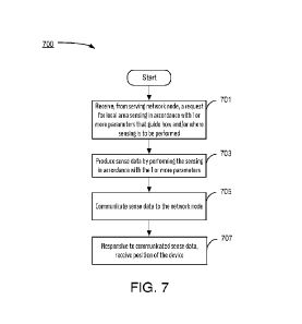
UEs. With a limited geographical area the database with map information and
historical data, as
well as optimization based on knowledge of all UEs in the area, can be
efficiently implemented.
Furthermore, with the co-located system there are also significantly fewer
performance reducing
latencies compared to a remote over-the-top datacenter.
Later in this description, it is also pointed out that, in some alternative
embodiments
consistent with the invention, some of the mobile edge functionality can be
handled in the
mobile devices themselves. However, such embodiments may be less efficient
than others.
Although in typical implementations a mobile edge function can be presumed to
serve
one base station, there are no principal obstacles preventing a mobile edge
function from serving
many base stations. Even though the maps and correlation as well as statistics
are related to a
local area, there might be several antenna sites served by one base station
109 and one mobile
edge server 113. In the following, the system, the solution, and the examples
assume one mobile
edge server 113 for this functionality, but the scope of the invention is not
limited to having only
one such mobile edge server 113 for this.
To illustrate some aspects of inventive embodiments, the description will now
make
reference to the exemplary signaling diagram illustrated in Figure 3A.
Features depicted with
dotted lines and boxes represent aspects that are optional to this exemplary
embodiment.
CA 03239627 2024- 5- 29
WO 2023/098977
PCT/EP2021/083581
-13-
1. Device 101: Self-positioning is started (step 301) and as a consequence, a
request for a
network-based position is communicated to the base station 109 (step 303). The
network
executes a positioning technique that produces a coarse-grained position of
the mobile
device 101 (step 305). Coarse-grained positioning techniques are known in the
art and all
are contemplated to be within the scope of inventive embodiments.
2. The base station 109 or network function then communicates the coarse
position 211 to
the device (step 307). This action is included in this embodiment to
illustrate
environments in which there is no direct communication of this information
from the
base station 109 to the mobile edge server 113, so it is provided by the base
station 109 to
the mobile 101 which in turn forwards it to the mobile edge server 113. But in
alternative
embodiments, such as is shown in Figure 5 which is discussed below, the WRP is
passed
directly from the base station 559 to the mobile edge server 563, so there is
no need for
the mobile device 551 to receive it and then forward it.
3. Device 101: Receives the coarse position 211 from the network function,
which now
constitutes the WRP 211. Depending on the method used in the particular
embodiment,
the device 101 might also receive an indication of the confidence level (e.g.,
an indication
of degree of accuracy) of that position from the network function 109.
4. Device 101: Emit radar sequences and receive the response (step 309). The
settings for
the radar are based on the device knowledge of features indicated on the map
or based on
previously received guidance from the mobile edge server 113. For example, the
network
can look at the database and determine which directions have reliable amounts
of
available data that can be correlated with sensing data from the device and
ask the device
101 to use specific panels in those directions. If there is no previous
knowledge, the radar
parameters are based on default parameters. This is further described below.
5 Device 101 sends received radar data to mobile edge server 113 (step 311),
with the data
including parameter settings used in this sensing as well as WRP 211.
6. Mobile edge server 113 (or comparable mobile edge functionality implemented
in a
network node such as the base station 109) determines the WR-Frame 201 (step
313)
based on the WRP 211, potentially received confidence level of that WRP
estimate, and
historical information about WRP accuracy level of that position in that area
(based on its
database on prior estimates relative to determined accurate positions for all
devices in
that area historically). The area can be the whole network cell, or more
narrowly defined
based on the WRP. This function is further described below.
CA 03239627 2024- 5- 29
WO 2023/098977
PCT/EP2021/083581
-14-
7. Mobile edge server 113 determines a second, more accurate estimate 215 of
position 207
(step 315) based on the WR-Frame 201 and received radar data. This function is
further
described below.
8(alt1). Mobile edge server 113 sends the second (more accurate) estimate 215
of position
207 to the device (step 319).
9(alt1). Mobile edge server 113 updates its database with the relevant data
from the device
as well as the determined accurate position (step 331). This function is
further described
below.
In certain cases, the mobile edge functionality (i.e., implemented as a
separate mobile
edge server 113 or as an auxiliary function of a network node such as a base
station 109) might
not be able to determine the accurate position of the device with high
confidence/accuracy.
Reasons might be that the environment has changed, so there is no good
correspondence in the
data in the database (e.g., map, previous radar signals, etc.), or that the
WRP for certain reasons
is especially wrong in a specific case. One of the key advantages with the
technological approach
described herein is that the mobile edge function has a good overview of the
map and potential
reasons for the poor confidence of the estimated position, and can accordingly
provide guidance
to the mobile device 101 to perform additional measurements that are
configured to improve the
accuracy of the estimated position. Such guidance can be, for example:
- Move (a certain estimated distance in a known direction where according to
the radar
measurement there is no object in the way) and from there perform a new
measurement,
and send that new sensor data together with the estimated delta movement to
the mobile
edge function 113.
- Perform an additional measurement based on a different setting
of the radar signaling,
e.g. higher power, larger bandwidth, longer signal duration, additional
frequencies;
and/or based on directing one or more radar transmissions in a different
direction (e.g.,
using a different antenna panel) than had been performed earlier (e.g., with
the
expectation that the directions are associated with more distinct and unique
radar
signatures (e.g., as determined from available map data and data from previous
radar
scans at the network)); etc.
Based on this, the latter part of above flow becomes (as illustrated in the
dotted boxes and
signals in Figure 3A):
CA 03239627 2024- 5- 29
WO 2023/098977
PCT/EP2021/083581
-15-
8(alt2). Mobile edge function 113 determines most suitable parameters for
guiding
performance of additional measurements needed for a more accurate position
(step 317) As
noted above, this can involve the network looking at the database and
determining which
directions have reliable amounts of available data that can be correlated with
sensing data
from the device and ask the device 101 to use specific panels in those
directions.
9(a1t2). Mobile edge function 113 sends the second estimate (accurate) 215 of
position (as
determined at step 315) to the device, with an indication of (lower)
confidence level (step
3 19)
10. Mobile edge function 113 sends parameters to device 101 for guiding
performance of
additional measurements (step 321)
11. Device 101 performs additional measurements according to guidance (step
323)
12. Device 101 sends additionally collected data to mobile edge function 113
(step 325)
13. Mobile edge function 113 determines updated position based on the
additional data (step
327)
14. Mobile edge function 113 sends updated position with updated confidence to
device 101
(step 329)
15. Mobile edge function 113 updates its database with the relevant data from
the device as
well as the determined accurate position (step 331).
In an alternative class of embodiments, Figure 3B is an exemplary alternative
signaling
diagram that is, in most respects, identical to Figure 3A except with respect
to determination of
the coarse position. Instead of this being determined at the base station 109
(as illustrated in
Figure 3A), the first (coarse) estimate 211 of position 207 (and possibly also
an estimate of
confidence in the first position) is determined by the mobile device 101
itself. This determination
can be performed by a number of different ways including, but not limited to,
use of a Global
Positioning System (GPS) circuit within the mobile device 101 (step 351). In
all other respects,
the actions depicted in Figure 3B are the same as the corresponding actions
depicted in Figure
3A, and for this reason reference is made to the description of Figure 3A for
a description of
these depicted actions in Figure 3B.
Further description of some of the above-mentioned steps is provided later in
this
document.
CA 03239627 2024- 5- 29
WO 2023/098977
PCT/EP2021/083581
-16-
For further illustration, Figure 4 shows an example when the mobile device
(UE) 401 is
in a surrounding area In accordance with aspects of the steps illustrated in
Figure 3, the mobile
edge function 113 has estimated the device's position 207 as WRP 211 having a
corresponding
WR-Frame 403. It can be seen that the device's estimated position, WRP, is
inaccurate by an
amount 6. The illustrated shapes filled with crosshatching represent nearby
structures/objects
(e.g., walls, machines, furniture).
In the basic operation of the examples shown in Figure 3A, the UE 401 receives
the WRP
(i.e., it is estimated position), and performs the radar operation in
accordance with the received
guidance. In this exemplary case, radar signals are emitted in four beam
directions, and for each
beam direction, the UE 401 receives the reflections and estimates or
calculates the radar response
signal characteristics (e.g., latency, strength, Doppler characteristics,
shape, etc.). The WRP and
the received radar data (e.g., raw reflected radar signals or a processed
version of them with
extracted useful information) are sent to the mobile edge function 113. (The
UE 401 sending the
WRP to the mobile edge function 113 is included here to illustrate embodiments
in which there
is no direct communication of this information from the base station 109 to
the mobile edge
server 113. But in alternative embodiments, such as is shown in Figure 5 which
is discussed
below, the WRP is passed directly from the base station 559 to the mobile edge
server 563, so
there is no need for the mobile device 551 to do this.) The mobile edge
function determines the
WR-Frame 403, and correlates the data derived from the radar signals with one
or more
reference maps 213 and/or previously recorded radar signals generated at known
positions and
maintained to estimate possible positions within the WR-Frame 403. Based on
its holistic
knowledge of the map 213 (known objects and their respective positions) that
corresponds to the
WR-Frame 403, as well as recorded radar signal characteristics from different
positions within
the WR-Frame 403, a more accurate estimate of the UE's position 207 is
determined. In fact,
given the different distances and signal characteristics from the different
objects and structures, it
can be determined that only a specific point in the WR-Frame 403 can be
possible.
In certain theoretical situations, there might be multiple possible positions
within a WR-
Frame 403 that can lead to a same set of radar responses, but then one
iteration with additional
data (for example, by guiding the device 401 to move a certain distance, and
perform another
radar measurement which is then analyzed) would typically be sufficient to
resolve the
uncertainty except in very rare situations.
Since there are multiple beam directions and multiple objects being reflected,
the
correlation analysis is preferably configured to be able to handle certain
deviations, for example
CA 03239627 2024- 5- 29
WO 2023/098977
PCT/EP2021/083581
-17-
when individual objects have moved but the majority of the scene is stable In
certain cases,
more disruptive changes of the scene are possible (larger fraction of objects
moved).
Optimizations described below can help resolve such situations.
Note that even if the edge mobile function 113 correlates only for positions
within the
WR-Frame 403, it uses reflections from objects and structures outside the WR-
Frame 403 (e.g.,
from the object 405). Radar beam directions, and also the WR-frame 403, need
not be contained
within only the X-Y dimension, but can also include upwards and downwards
directions
depending on system and needs.
In some embodiments, radar data from devices can include time stamps and an
estimated
mobility vector during the scan to take into consideration scans made from
different positions.
This enables further analyses and accuracy in the mobile edge function 113
since it takes into
consideration multiple positions, and further consolidated knowledge on the
trajectory of all
devices in the area.
Some aspects mentioned above are further described in the following:
Emitting radar sequences and receiving the responses
In simplistic implementations, the device 101 can emit radar beams in all
directions
according to some default radar settings and send the received signal
responses to the mobile
edge function 113 (jointly with WRP and radar settings). However, there are
several problems
with this:
- The radar settings might be sub-optimal with respect to the actual
context (e., g. distances
to relevant objects in various directions, width of beams, certain types of
objects
demanding certain radar settings for optimal performance)
- If radar is performed in the spectrum defined by 3GPP standards, the
radar operation
needs to take interference into account both with respect to interference
caused to other
devices by the radar signals and also interference from other devices that
might disturb
radar reflections. Depending on relative position of device to other devices
and base
stations, there might be certain directions, frequencies, and output power
levels that must
be avoided.
- For moving devices, close proximity to other device under mobility and to
certain key
objects might necessitate tighter real-time operations or caution, whereas
some other
situations might be more relaxed in terms of real-time demands.
CA 03239627 2024- 5- 29
WO 2023/098977
PCT/EP2021/083581
-18-
Embodiments consistent with the invention enable optimized operation since the
mobile
edge function 113 has knowledge of the overall map, as well as where all
devices are positioned
and their recent movements, and information on all base station positions.
Optimizations enable
adapting the radar to the environment, depending on expected distances and
types of structures,
and the radar output power, waveform, and duration might be different in
different directions.
This enables the following optimizations:
A When the mobile edge function 113 sends the accurate position to the device
101, it also
sends certain key information about the area / vicinity: for example closeness
/ direction
to other mobile devices and base stations, closeness to certain key objects or
structures,
and other key relevant information needed (e.g., whether there are certain
rapid changes
in the environment).
B. When the data in step (7) above is not sufficient for an accurate
determination of the
position, for example due to certain key objects having moved, the mobile edge
function
113 can send further guidance to receive additional data: not only to the
current device
(step (10) above) but also to other nearby devices that can help collect
additional updated
knowledge on the environment from their respective positions. The exact
protocols and
rules for such procedures are beyond the scope of this description but there
are several
different alternative solutions that are within the ability of those of
ordinary skill in the
art (e.g., UEs making use of this positioning service might also be assumed to
assist with
additional measurements when needed if there is no issue for them doing so).
C. Further below in this document, an alternative embodiment is described that
involves
integrating certain optimized measurement in every radar operation.
By performing several subsequent positionings, potentially with estimates of
movement
in-between (if the device has the ability to estimate movement) the mobile
edge function 113 can
determine the position with even greater accuracy and in some but not
necessarily all
embodiments, apply optimizations such as reducing the size of the WR-Frame 403
for specific
cases, only correlating to certain parts of the maps, and the like.
Mobile edge function 113 determining the WR-Frame 403
CA 03239627 2024- 5- 29
WO 2023/098977
PCT/EP2021/083581
-19-
There are multiple methods for determining the WR-Frame 403. In one of the
simpler
ways, a radio-based positioning scheme is used that includes indicating the
degree of accuracy
that can be expected (e.g., 5 meters) and the WR-Frame 403 then becomes WRP
5m in each
dimension. See, for example, Figure 2. And as mentioned earlier, the WR Frame
403 can
alternatively have another shape, such as but not limited to circular,
ellipsoid, or spherical.
Another way of determining the WR-Frame 403 can be utilized if a position was
recently
determined, and if the speed (or maximum speed) of the device is known as well
as direction and
acceleration (or maximum acceleration). So long as the amount of time since
the previous
location determination is not large, a much smaller WR-Frame 403 can then be
used.
However, as that confidence interval becomes pessimistic (must take the worst-
case
degree of accuracy for that method into consideration), an aspect of inventive
embodiments
provides further improvement.
More particularly, for each performed self-positioning, the mobile edge
function 113
adds the related information to a stored history of WRP, the methodology
employed to arrive at
WRP, and the accurate position finally produced from the radar analysis. Over
time, the mobile
edge function 113 builds up an excellent statistical knowledge of the actual
confidence interval
for different WRP-methods at the different parts of the whole area ¨ certain
places might have
reasonably good WRP accuracy (e.g., line of sight with base station) whereas
others have very
poor WRP accuracy (e.g., due to challenging radio conditions). The mobile edge
function 113
further can collect statistics about WRP accuracy deviations between different
modem models,
and the like . Such collected information can, for example, be used as the
subject of machine
learning / analytics to enable accurate predictions and/or estimates and/or to
identify how
different factors impact accuracy. Therefore, after having performed a large
number of accurate
positioning services, some but not necessarily all embodiments consistent with
the invention
enable the mobile edge function 113 to be able to provide an optimized WR-
Frame 403 taking
both the environmental conditions as well as modem-type differences into
consideration. This
also benefits the positioning accuracy of non-radar UEs.
Mobile edge function 113 determining accurate position
Given the knowledge that the mobile device is within the WR-Frame 403, the
task is for
the mobile edge function 113 to correlate the radar signal data with data in
the mobile edge
server 113. This can be done according to several different approaches, such
as but not limited
to:
CA 03239627 2024- 5- 29
WO 2023/098977
PCT/EP2021/083581
-20-
A. The radar data provides information for different beams on objects at
certain distances.
The mobile edge function 113 correlates this against map information and/or
previously
recorded radar signals obtained at known positions that it is maintaining, and
determines
the most likely position within the WR-Frame 403, with the least number of
anomalies
(reflections with no object correspondence in the map, or objects without any
radar
reflection) or any other algorithm with the best correlation (e.g., an
algorithm that takes
the size of anomaly or deviation into account). In this respect it is
advantageous to, at
certain intervals, redo or re-calibrate the algorithm based on historical data
so that it can
be determined, for example, whether the number of anomalies can be
significantly
reduced if certain structures or reflections are disregarded.
Anomalies might imply objects that have been moved, or objects with
challenging
reflection characteristics, which are recorded for future correlation analysis
and potential
update of the map information. Furthermore, the mobile edge function 113 can
detect
patterns changing over time, such as certain objects in the environment that
are present
only at certain times in which case the correlation data can include a timing
variable
associated with these objects.
B. The radar signals are correlated with a database of previous radar signals
from different
positions in the WR-Frame 403 according to a fingerprinting technology (e.g.,
technology that relies on known landmarks within the environment). Also for
this,
detected timing patterns can be determined and exploited (see above
paragraph).
C. A combined approach between (A) and (B) when there are no previous radar
signals from
relevant positions. In such cases, methodology described in (A) is used but
the radar
signals are stored for future applications of the methodology described in
(B).
Mobile edge function 113 updates its database with the relevant data
An aspect of embodiments consistent with the invention is the ability of the
mobile edge
function 113 to correlate radar data against the recorded map data/database
and make
optimizations based on recorded data and to have a holistic view of the system
status (e.g., most
recent position process of UEs and their trajectories, most recent position
process of relevant
major objects, etc.).
The mobile edge function's database includes:
CA 03239627 2024- 5- 29
WO 2023/098977
PCT/EP2021/083581
-21-
= Map information, in a form that is conducive for correlating against
radar reflections (at
different radar parameter settings), with detailed position data of objects
and structures.
= Radar reflection characteristics from different directions of those
objects and structures
identified in the map. These can initially be calculated based on the
structural map
(above) given certain knowledge about material and shape. These can also be
initially
measured based on an enhanced device with a high-precision sensor, and only
need to be
done once. In an aspect of embodiments consistent with the invention, this
information is
continuously updated as the system is in use.
= Radar signal reflections from actual devices in use, annotated with
different parameter
settings of the radar at the measurement.
= Original WRP position and method of each positioning case, together with
the accurate
position derived from the radar correlation.
Furthermore, the mobile edge function 113 maintains an updated map with all
connected
devices using this positioning service. This enables the mobile edge function
113 to apply
optimizations with respect to letting devices complement weak information of
certain areas, and
with respect to which beam directions might be more subject to interference
from radar
transmission (3GPP bands and/or others). Finally, this information also
enables additional types
of services based on detailed positioning and trajectory information of all
devices in the area
jointly with an updated view on objects and structure in that area, without
demanding that the
devices be equipped with cameras which would otherwise add cost and might be
seen as a
privacy concern. Further detail about such services is beyond the scope of
this description.
Creation of database data for mobile edge function 113
The database of the mobile edge function 113 needs to be initially populated
and then
later refined iteratively through the usage ¨ the more it is used and the more
devices, the better
and richer it becomes
In one embodiment consistent with the invention, the initial content can be
recorded with
a certain enhanced device that has additional sensors to determine its
distance moved from
known accurate positions. Furthermore, a map of the environment with all
static objects and
structures can be created. Creation of the initial map needs to be done only
once (in a factory,
this might be walls, big machinery, and other notable objects), but this might
exist from the stall_
This enhanced device records radar signals and determines how the radar echoes
make certain
CA 03239627 2024- 5- 29
WO 2023/098977
PCT/EP2021/083581
-22-
objects visible at different distances. All this data is recorded into the
database, and the map of
structures and objects is updated based on its visibility and characteristics
from a radar
perspective.
In another embodiment consistent with the invention, an enhanced device having
a
camera uses some sort of Simultaneous Localization and Mapping (SLAM) (many
solutions
exist that are compatible with inventive embodiments) to create a map of the
environment, and
uses radar to annotate or update that map based on its radar reflection
characteristics. This
SLAM implementation need not be optimized, since this is essentially done only
once. It is also
possible to re-do this procedure at different intervals, but then it is not to
create the initial map
and radar signal content, but to update the database based on certain objects
having moved or
been added ¨ in principle getting a confirmation from deviating recent radar
measurements
where anomalies have been identified.
Positioning accuracy
The positioning accuracy of the herein described technology depends on the
radar
signaling characteristics.
For example, a wider signal bandwidth enables more accurate measurements and
resolves
more details in the targets, hence providing more information for positioning.
Signal to noise
ratio is also of fundamental importance to radar measurement quality, and this
can be improved
by increased output power or by longer correlation time. The required output
power and
correlation time, however, grows quickly with target distance, and beyond a
certain distance it
becomes impractical to resolve small objects Long correlation times also
become increasingly
difficult to combine with movements. To minimize the resources used and
maximize the
accuracy of the positioning, it is thus better to, if possible, target nearby
objects with relatively
low power and duration, but with high signal bandwidth The position accuracy
will be a fraction
of the inverse signal bandwidth multiplied by the speed of light. If, for
example, a few GHz
signal bandwidth is used, the accuracy obtained by correlation of the signal
modulation can be a
few centimeters.
In general, more distant objects would also likely lead to somewhat less
accurate
measurements than would those that are close-by. This is in one respect due to
longer delay
before being received which gives more influence to clock jitter. It is also
due to more potential
unknown properties of such a long and wider signal propagation path (the beam
has a finite
opening angle). However, if nearby objects are missing, a reduced accuracy is
tolerable for most
CA 03239627 2024- 5- 29
WO 2023/098977
PCT/EP2021/083581
-23 -
applications, as the closer a device is to objects in its surrounding, the
more accurate the
positioning needs to be. Furthermore, other radio-based positioning
technologies perform the
worst in the close presence of significant structures and objects (more
challenging radio
channels, no line of sight with base stations) which is exactly the scenario
for which the
presently described technology can provide down to cm-accurate positioning.
The nature of the
methods thus make them complementary.
The listing of every possible radar characteristic that can be exploited for
more in-depth
assessment is beyond the scope of this description, as that also depends on
the radar
implementations in the devices. But overall, an important advantage of the
presently described
technology is that the mobile edge function 113 has a holistic understanding
of the environment
which enables the guidance to optimize the radar measurements depending on
needs.
Alternative Embodiment: Guided radar operation
To illustrate some further aspects of some but not necessarily all alternative
embodiments
consistent with the invention, the description will now make reference to the
exemplary
signaling diagram illustrated in Figure 5. Features depicted with dotted lines
and boxes represent
aspects that are optional to this exemplary embodiment.
I. The mobile device 551 begins its self-positioning application (step 501)
and consequently
sends an self-position initialization request (step 503) to the base station
559 or other
network function.
2. The base station 559 or other network function performs an initial network-
based
positioning function to determine WRP (potentially with some confidence level)
(step
505) and provides this to the mobile edge function 563 (step 507).
3. The mobile edge function 563, in response, determines the WR-Frame that
corresponds
to the position WRP (step 509) and also determines parameters for guiding the
radar
operation based on the area, relevant objects in the surrounding, its allowed
use of radar
in certain frequency bands, and the like (step 511). In some but not
necessarily all
embodiments, the guidance can also be based on whether and what kind of radar
capability the device 551 has (e.g., whether it has SAR capability). Device
capability
information can be supplied to the mobile edge function 563 in any number of
ways
including but not limited to receiving it from the device 551. By performing
the sensing
in accordance with the mobile edge function's guidance, the device 551 can
always
perform its radar operation in an optimized way that takes into account the
mobile edge
CA 03239627 2024- 5- 29
WO 2023/098977
PCT/EP2021/083581
-24-
function's holistic knowledge of the map in that area, all other mobile
devices and known
dynamics in the environment, and previous historical measures from other
devices in that
area. The mobile edge function 563 then sends the WR-Frame and radar guidance
parameters to the mobile device 551 (step 513).
4. The device 551 then emits radar sequences and receives the response (step
515). The
settings for the radar are based on the device knowledge of features indicated
on the map
and on previously received guidance from the mobile edge server 113. This is
further
described below.
5. The device 551 then sends received radar data to the mobile edge server
563 (step 517)
along with parameter settings used in this sensing since, in some embodiments,
these may
deviate from the guidance provided by the mobile edge server 563.
6. The mobile edge server 563 determines an accurate position (step 519) based
on the WR-
Frame and the received radar data, and sends this to the mobile device 351
(step 521).
7(alt1). The mobile edge server 363 updates its database with the relevant
data from the
device 351 as well as the determined accurate position (step 535).
As in an earlier described embodiment, in certain cases, the mobile edge
functionality
might not be able to determine the accurate position of the device with high-
enough
confidence/accuracy with the sensor data that it has. To address this issue,
the mobile edge
function, which has a good overview of the map and potential reasons for the
poor confidence of
the estimated position, provides guidance to the mobile device 551 to perform
additional
measurements that are configured to improve the accuracy of the estimated
position Such
guidance can be, for example:
- Move (a certain estimated distance in a known direction where according
to the radar
measurement there is no object in the way) and from there perform a new
measurement,
and send that new sensor data together with the estimated delta movement to
the mobile
edge function 563.
- Perform an additional measurement based on a different setting of the
radar signaling,
e.g. higher power, larger bandwidth, longer signal duration, additional
frequencies, etc.
Alternatively and/or additionally, it may be that the device 551 is known,
with sufficient
accuracy, to be located in a local area for which historical sense data that
is available to the
server 113 does not satisfy at least one predetermined criterion. For example,
a predetermined
CA 03239627 2024- 5- 29
WO 2023/098977
PCT/EP2021/083581
-25-
criterion may be a certain level of sense data associated with a particular
direction at that
location. By guiding the device 551 to perform sensing in that direction and
to report the sense
data back to the server 113, the server's database of historical sense data
can be supplemented
and thereby improved for future use.
Based on this, the latter part of above flow becomes (as illustrated in the
dotted boxes and
signals in Figure 5)
7(a1t2). The mobile edge function 563 determines parameters for performing the
most
suitable additional measurements needed for a more accurate position (step
523)
8. The mobile edge function 563 sends the parameters to the device 551 for
guiding
performance of additional measurements (step 525)
9. The device 551 performs additional measurements according to the guidance
(step 527)
10. the device 551 sends additionally collected data to the mobile edge
function 563 (step
529)
11. The mobile edge function 563 determines and updated position based on the
additional
data (step 531)
12. The mobile edge function 563 sends the updated position with updated
confidence level
to the device 551 (step 533)
13. The mobile edge function 563 updates its database with the relevant data
from the device
as well as the determined accurate position (step 535).
Additional Alternative Embodiments
Centralized vs. de-centralized database
Parts of the database can be downloaded and stored in the device/UE 101 so
that the
correlation / fingerprinting takes place there instead of in the mobile edge
function 113,
potentially to operate at an even higher correlation rate or to decrease the
use of communication
resources (and freeing up even more opportunities for radar operations). In
advantageous
embodiments, the results (raw data measurements not the actual self-position)
are shared with
the mobile edge function database so that that data can be available to serve
other UE's.
Therefore, some embodiments consistent with the invention are not dependent on
the
mobile edge function 113 containing all of the functions described above. To
the contrary,
aspects described above are applicable even in a distributed solution in which
parts of the
CA 03239627 2024- 5- 29
WO 2023/098977
PCT/EP2021/083581
-26-
processing and data are managed by individual devices, enabling them to
benefit from sharing
data, map information, changes in the environments, and statistics through a
function such as the
mobile edge function 113. Furthermore, the knowledge of all positions of the
devices enables
many advantages, which in the various described embodiments is described as
residing in the
mobile edge function 113.
A person of ordinary skill in the art will readily understand that the mobile
edge function
113 can be partly distributed in terms of actual processing and data access,
but the devices need
to share and collaborate in a way which is naturally managed by the mobile
edge function 113 in
the description set forth above. Therefore, the functions of the mobile edge
function 113 and of
the devices constitutes advantageous embodiments, but other embodiments are
also
contemplated being within the scope of the invention.
Certain key structures or radar-posts
In some embodiments, certain structures or objects having distinct radar
reflection
signatures and considered stable in their position can be identified and
specifically taken into
consideration. In the general case, this can be any object or structure with a
distinct radar
reflection characteristic, but in the specific case this can be specific
reflections designed for this
purpose.
In one class of embodiments, the environment where the device is located may
include a
few dedicated reference points (e.g., radio reflectors, passive anchor points
or iconic objects with
distinguished RF characteristics). The objects can be wideband reflectors, or
resonant structures
with different properties at a particular resonance frequency They could be
polarized to reflect
only one polarization. Still further embodiments comprise combinations of the
above. There can
also be different properties in different directions. Some structures could
change shape with
environment conditions and also enable remote sensing with radar
In one aspect, these reference points can be arranged in the environment with
a special
location pattern. This can help the map correlation or fingerprinting
algorithm increase its
convergence rate. Furthermore, in case of ambiguity, the mobile edge function
113 can guide the
device to beam its radar towards known such objects in order to determine or
confirm position or
direction.
Exploiting nearby devices
CA 03239627 2024- 5- 29
WO 2023/098977
PCT/EP2021/083581
-27-
Since the mobile edge function 113 maintains an updated view of where all
radar-
equipped devices are, the system can exploit this by, based on their latest
known positioning
requests and estimated trajectories, letting devices transmit/receive directly
between each other
to obtain further knowledge about their relative positions as well as for bi
static radar operation in
order to get a better view regarding the objects between them. The details of
this is beyond the
scope of this description.
How to obtain alternative coarse-grained world (absolute) reference
It is expected that a coarse-grained world reference position (WRP) can be
obtained by a
number of alternative means with varying costs in terms of power need, quality
of the position
and need for connectivity. An onboard GPS receiver can be used if available or
be combined
with network positioning for even higher quality of position, faster
acquisition (so called assisted
GPS), and the like.
In another aspect of some but not necessarily all embodiments, aspects
described above
can be used to provide a coarse-grained starting point by guessing where the
device might reside
given a map of the environment. Such a solution is entirely self-contained and
would not depend
on having a GPS and line of sight towards a satellite.
Yet another embodiment takes advantage of previous data points and, based on
age of
data points (more recent measurements are generally preferred) and presumed
shift of position
over time, reuses historical data obtained by the same system which would
provide the most
energy efficient generation of the coarse-grained world reference.
It is noted that as the positioning system continues to operate and refine the
actual
position this also functions to provide the device 101 with a new and accurate
reference point
effectively sub-planting the coarse-grained reference with a continuous high
quality position
only limited by the quality of the map data, the ranging resolution of the
onboard radar, and the
like.
Alternative device sensor such as IMU, accelerometer or compass
The various embodiments consistent with the invention do not depend on the use
of an
IMU, compass, or gyro, even though the function would benefit from that
additional sensor to
primarily determine direction. Knowing device orientation simplifies the
correlation of radar
signals relative to a map and simplifies guided radar operation since
different directions can be
pointed out by the mobile edge function 113. However, by analyzing the
correlation from the
CA 03239627 2024- 5- 29
WO 2023/098977
PCT/EP2021/083581
-28-
different beams over multiple positions, it is possible for the mobile edge
function 113 in
collaboration with the device to determine its orientation without this
additional sensor.
However, this requires a greater effort.
It is noted that an IMU in the most general sense can be anything that is able
to measure
the orientation and intrinsic motion of a device. Typically, this is done
without the need for
external information such as using a microelectromechanical system (MEMS)
sensor setup with
a gyro, an accelerometer and a magnetometer giving a device nine degrees of
freedom (9DoF).
This is not necessary for the function of the inventive embodiments, but can
be used to provide
additional datapoints to validate measurements and also fine tune the
resulting position when
combined with the radar based self-positioning. It is noted that typical IMUs
are prone to drift
over time (when used as a dead reckoning function) and typically need to be re-
aligned with
more stationary data points. The radar based self-position provided by
inventive embodiments as
described herein provides just that function.
In the absence of other means (e.g., intrinsic, such as IMU) or extrinsic
methods (with an
external entity providing the tracking of device inertial motion and change of
orientation, aka
Virtual IMU) the various embodiments will still work accurately as the map
correlator function
not only provides a reliable baseline (once it is locked to the correct and
identified radar features)
but also measures an accurate offset (or distance from) the identified (or
fingerprinted) features.
Adding information from beam directivity in communication towards the base
station
from a device know used panel will provide a relative orientation of this
panel towards the base
station 109 which has a known position in the room. This information might
already be available
as part of the initial network based positioning giving the WRP From this,
other sensors could
detect a change. Or, if the device regularly performs communication towards
the base station, it
will also get this updated during self-positioning tracking
Additional aspects of inventive embodiments will now be described with
reference to
Figure 6, which is, in one respect, a flowchart of actions performed by an
exemplary server (e.g.,
a network component configured to have edge mobility functionality) configured
to determine a
location of a first mobile communication device in accordance with a number of
embodiments.
In other respects, the blocks depicted in Figure 6 can also be considered to
represent means 600
(e.g., hardwired or programmable circuitry or other processing means) for
carrying out the
described actions.
As shown beginning in Figure 6, the process includes the server obtaining a
first estimate
of position of the first mobile communication device, wherein the first
estimate of position
CA 03239627 2024- 5- 29
WO 2023/098977
PCT/EP2021/083581
-29-
indicates with a first degree of accuracy that the first mobile communication
device is positioned
within a local area portion of a reference coordinate system (step 601) The
server then
determines one or more parameters for a sensing of the local area (step 603),
and sends, to one or
more of the first mobile communication device and another mobile communication
device, a
request for the sensing of the local area in accordance with the one or more
parameters (step
605) In response to the request for the sensing of the local area, the server
receives sense data of
the local area (step 607). The server uses the sense data of the local area to
produce a second
estimate of the position of the first mobile communication device, wherein the
second estimate
of position indicates with a second degree of accuracy that the first mobile
communication
device is positioned within the local area portion of the reference coordinate
system, wherein the
second degree of accuracy is more accurate than the first degree of accuracy
(step 609).
In some but not necessarily all embodiments consistent with the invention, the
accuracy
of the position estimate is further improved by the server determining even
further parameters for
guiding even further sensing of the local area by the mobile communication
device, and using
this further sense data to further improve the estimated position of the first
mobile
communication device. The number of times that guided sensing followed by
further refinement
of the estimated position can be performed is implementation dependent, and
can for example be
a fixed number of times, or can alternatively be based on reducing an error
level down to an
acceptable level (where a threshold for acceptability is implementation
dependent). All such
embodiments are represented in Figure 6 by action 611.
In view of the range of embodiments represented by Figure 6, it will be
understood that
the term "first estimate of position" may be understood to generally represent
a most recently
obtained and/or determined estimate of the position of the mobile
communication device, and
that the term "second estimate of position" may be understood to generally
represent a
subsequently determined position estimate having a greater accuracy than that
of the first
estimate.
The discussion will now cover exemplary embodiments with a focus on aspects
located
in the mobile device itself.
Figure 7 is, in one respect, a flowchart of actions performed by an exemplary
mobile
communication device configured to perform sensing in accordance with a number
of
embodiments to produce data that can be analyzed to estimate the position of
the mobile
communication device. In other respects, the blocks depicted in Figure 7 can
also be considered
CA 03239627 2024- 5- 29
WO 2023/098977
PCT/EP2021/083581
-30-
to represent means 700 (e.g., hardwired or programmable circuitry or other
processing means)
for carrying out the described actions.
As shown in Figure 7, the process includes the mobile communication device
receiving,
from a network node that serves the mobile communication device, a request for
sensing of a
local area in accordance with one or more parameters that guide how and/or
where the sensing is
to be performed (step 701). The type of sensing performed is different in a
number of alternative
embodiments. For example, some embodiments employ radar sensing as discussed
above. But in
alternative embodiments other types of sensing can be used such as optical
sensing (including
but not limited to camera sensors and LIDAR), inertial sensing by means of an
inertial
measurement unit (IMU), acoustic sensing (e.g., ultrasonic), sensing via a
combination of
different antenna panels of a (e.g., mobile) device, and sensing by means of
Synthetic Aperture
Radar (SAR). Embodiments employing SAR are described in greater detail later
in this
description.
In response to the request for the sensing of the local area, the mobile
communication
device produces sense data by performing the sensing in accordance with the
one or more
parameters (step 703). As discussed earlier, this may involve the mobile
communication device
performing the sensing in a particular direction and/or moving to a particular
location from
which the sensing is performed.
After producing the sense data (either raw sense data or, in alternative
embodiments,
sense data that is the result of processing raw sensing data by the mobile
communication device),
the mobile communication device communicates it to the network node (step
705).
In response to communicating the sense data to the network node, the mobile
communication device receives its position (step 707) The position can, for
example, be
produced by a network node as described above.
As mentioned earlier, the mobile communication device can employ a number of
different types of sensing. SAR sensing is one type that can advantageously be
used in inventive
embodiments. SAR sensing involves the performance of radar measurements from
multiple radar
antenna positions relative to a target. Known processing techniques are
employed to combine the
recorded radar sampling data to form a SAR radar image with higher spatial
resolution than is
possible with a single-shot radar. When SAR is used in embodiments consistent
with the
invention, a particular benefit is achieved by using mmWave radar signals
because the short
wavelength and wide available bandwidth leads to high resolution which, when
coupled with
mmWave signals' ability to penetrate materials better than higher frequency
signals, leads to the
CA 03239627 2024- 5- 29
WO 2023/098977
PCT/EP2021/083581
-31-
production of high resolution images having an increased signal to noise
ratio. This enables the
detection of features that are ordinarily hidden to other sensing techniques
(e.g., "see through"
cloth or "see in" walls).
Techniques for embodying mmWave radar in a mobile communication device are
known
in the art, such as embodiments shown in International Patent Application
"Radar
Implementation In a Communication Device", PCT/EP2020/069491. For example, it
has been
shown that it is possible to extend UE modem capability to include mmWave SAR
functions.
The added cost of the radar functionality on top of that of an ordinary 5G
modem is minimal.
This means that the modem can be used for the essential functions of the
positioning system
which include, for example:
- Communicating with the base station and the functions in the mobile edge
server
- Radar sensing at mmWave frequencies, different beam directions, and with
different
signaling types and durations
Although a 5G modem has been mentioned, this is merely for purposes of example
and is
not an essential aspect of inventive embodiments. Those of ordinary skill in
the art will
appreciate that other communication standards or generations of the 3GPP
standard can
alternatively be used in embodiments consistent with the invention.
Using the device's modem for radar functionality is not an essential aspect of
inventive
embodiments. In alternative embodiments, the radar functionality might be
provided by a
separate module that communicates through the 5G modem to access the network-
based aspects
in accordance with embodiments consistent with the invention. Having a
separate radar module
adds cost and complexity, however.
In another aspect, a mobile device in some but not necessarily all embodiments
is
equipped with an IMU or accelerometer, gyro, compass or other sensor(s) to
extract/estimate
SAR scanning trajectory. These sensors can also be used to understand device
orientation and
relative movements to further support the positioning scheme (e.g., as may be
required to
perform the network guided scanning as discussed above).
In overview, then, radar sensing capabilities in a mobile device can be
achieved with a
minimal hardware change to its radio communication circuit. For example, in a
5G cellular
phone, mmWave radar functionality can be implemented by using the RF
beamforming
transceiver. By performing mmWave radar measurements from varying positions
relative to a
CA 03239627 2024- 5- 29
WO 2023/098977
PCT/EP2021/083581
-32-
concealed object (e.g., inside a wall) SAR processing techniques can combine
the recorded data
from the multiple radar antenna positions to form a SAR radar image of the
concealed object
with high resolution. Other sensors, for example an IMU, can be used to
estimate/extract radar
sampling positions and compensate the variable movement of SAR scanning
trajectory. The
SAR radar technology can be leveraged to assist the mobile device locate
itself in a map or
relative to recorded radar data through fingerprinting methods.
A mobile device equipped with a mmWave radar moves around in a scene and
performs
SAR scanning on its surrounding objects (e.g., walls, floors and ceilings). By
looking through a
wall (and/or floor, ceiling, etc.) with high resolution, the device can detect
the detailed structures
within the wall. The detected structures can then be used as a fingerprint
that is correlated with
map information in which the features of the wall are stored. From the
correlation results, the
position of the device in the map can be estimated.
The achievable accuracy with a SAR-assisted method is much better than what
traditional
radar-based positioning solutions can achieve. Applications include autonomous
carts driving
around on a factory floor, or drones in an indoor environment, but there are a
large number of
other potential applications for this technique.
As mentioned above, a mobile device performing self-positioning may find
itself in
certain areas in which the conventional radar sensing from the device cannot
capture sufficient
recognizable objects to locate itself Such an area could for example be a long
corridor with flat
walls or areas where static recognizable objects might be blocked by moving
people/objects
which dynamically change the radar environment. If the device is equipped with
an IMU, this
can assist to some extent to make a prediction (e g , within a corridor) but
accumulated IMU
errors could increase and thereby reduce overall accuracy.
To invoke SAR-assisted self-location, a decision should be made whether the
device has
entered such an area, and this can be based on one or a combination of
- A currently known estimate of position and the moving vector of the
device
- Edge cloud knowledge from previous self-positioning operation of the
device or other
devices
- Knowledge of building structures which may be included in a map stored in
the edge
cloud
- Knowledge about areas densely populated with moving objects (like people
at the
entrance of a shopping mall at peak hour) blocking radar view towards
recognizable
objects
CA 03239627 2024- 5- 29
WO 2023/098977
PCT/EP2021/083581
-33-
The radar self-positioning performance of a device in such areas could be
improved by
adding radar reflectors/anchors with some detectable characteristics. However,
due to various
reasons (e.g., esthetic reasons) it might not be a desirable and/or feasible
alternative.
With the herein-described mmWave SAR technique, it is possible for a device to
detect
structures with high resolution inside a building material. Consider, for
example, a wall. A wall
generally consists of invisible equidistant load bearing material of either
solid wood or metal
covered by external plasterboard. Other objects that may be located inside a
wall include cables
or other electrical items or water pipes. These features can be detected by
SAR and exploited by
the device to locate itself.
An exemplary system utilizing mmWave SAR technology for self-positioning
comprises:
- Mobile devices (e.g., smartphones, tablets, XR/VR headset) with either a
mmWave
Radar module or a modem (or UE, User Equipment), that is extended with mmWave
Radar functionality. The devices can also be equipped with IMU sensors to
estimate/extract radar sampling positions.
- A cellular communication system in which the UE's are communicating with
a base
station.
- An edge cloud server. This can be a separately located network entity, or
can
alternatively be a server residing at the base station for providing services
that are local
to that area and with lower latencies than going over-the-top to a datacenter
beyond the
perimeter of the telecom operator.
- With a mobile device performing mmWave radar measurements from varying
positions
relative to a concealed object (e.g., inside a wall, above a ceiling), SAR
processing
techniques are employed by the mobile device in some embodiments to combine
the
recorded data from the multiple radar antenna positions to form a SAR radar
image of
the concealed object with high resolution. Other sensors (e.g., IMU) can be
used to
estimate/extract radar sampling positions and compensate for the variable
movement of
SAR scanning trajectory.
- In alternative embodiments, the communication modem in the mobile device
is used to
transfer the radar data to a network, which then processes the radar data to
reconstruct
SAR images and correlate the SAR images to a data set which can be extracted
from the
building structure or from previous measurements by the device itself or other
devices.
The processing (which can be computationally costly) of the radar data and
correlation
CA 03239627 2024- 5- 29
WO 2023/098977
PCT/EP2021/083581
-34-
with a set of known map features may further be done using a cloud server, a
mobile
edge function or even on the device itself (albeit at a cost of use of
additional power that
may drain the battery). Processing on the device itself assumes that a world
reference
position (WRP) and map data have been downloaded into the device.
- In one use case, when moving along one or more corridors/walls, a mobile
device
equipped with a mmWave radar performs SAR scanning on the wall(s). By looking
through the wall with high resolution, the device can detect the detailed
structures within
the wall (as shown in SAR radar images). The detected structure(s) (or
features extracted
from the SAR radar images) can then be used as a fingerprint and correlated to
a map
where the known feature of the wall is stored. From the correlation result,
the device can
estimate its self-position in the map. The method can be further extended to
floor (or
ceiling) SAR scanning.
To illustrate some further aspects of some but not necessarily all alternative
embodiments
consistent with the invention, the description will now make reference to the
exemplary
signaling diagram illustrated in Figure 8. Features depicted with dotted lines
and boxes represent
aspects that are optional to this exemplary embodiment. In this example, a
mobile device 801
and a mobile edge server 803 are able to communicate directly with one
another. Although the
mobile device is served by, for example, a base station 805, the base station
does not take part in
the mmWave SAR-assisted self-positioning actions. However, in some alternative
embodiments
the mobile device 801 may need to communicate with the mobile edge server 803
via the base
station 805 as an intermediary. Those of ordinary skill in the art will
readily understand how to
adapt the teachings presented herein for use in such embodiments.
7. The mobile edge function 803 determines a WRP-Frame that corresponds to a
current
estimate of the mobile device' s position (WRP) (step 807) that was determined
by other
means (e.g., by using any of the methods described above). The WRP can be
determined
by the mobile device 801 (see, e.g., Figure 3A and accompanying text) or by
the base
station 805 (see, e.g., Figure 5 and accompanying text).
8. The mobile edge function 803 decides (e.g., based on any one or more of
the factors
outlined above) that network-assisted self-positioning would improve the
current estimate
of position, and accordingly determines parameters for guiding the radar
operation based
on the area, relevant objects in the surrounding, its allowed use of radar in
certain
frequency bands, and the like (step 809). In some but not necessarily all
embodiments,
CA 03239627 2024- 5- 29
WO 2023/098977
PCT/EP2021/083581
-35-
the guidance can also be based on whether and what kind of radar capability
the device
801 has (e.g., whether it has mmWave SAR capability). Device capability
information
can be supplied to the mobile edge function 803 in any number of ways
including but not
limited to receiving it from the device 801. By performing the sensing in
accordance with
the mobile edge function's guidance, the device 801 can perform its radar
operation in an
optimized way that takes into account the mobile edge function's holistic
knowledge of
the map in that area, other mobile devices and known dynamics in the
environment, and
previous historical measures from other devices in that area. The mobile edge
function
803 then sends the WRP-Frame and sensing guidance parameters to the mobile
device
801 (step 811).
9. The device 801 then begins its self-positioning procedure (step 813) and
performs the
sensing in accordance with received parameters (step 815). For example, if
conventional
radar sensing or mmWave SAR sensing has been requested, the device 801 emits
radar
sequences and receives the response. The settings for the radar are based on
the device
knowledge of features indicated on the map and on the received guidance from
the
mobile edge server 803.
10. The device 801 sends resultant sense data to the mobile edge server 803
(step 819). For
example, the resultant data may be raw radar data. Alternatively, if mmWave
SAR
sensing has been performed, the raw data needs to be processed to reconstruct
SAR
images.
11. (optional) In some embodiments in which mmWave SAR sensing has been
performed,
the mobile device 801 reconstructs the SAR images (step 817), and these are
the resultant
data.
12. (optional) In some embodiments in which mmWave SAR sensing has been
performed,
the mobile device instead uses the raw radar data as the resultant data, and
the mobile
edge server 803 reconstructs the SAR images from the received raw radar data
(step 821).
13. The mobile edge server 803 correlates the received sense data with
reference sets of
previously obtained reflections from known positions that are stored in its
database (step
823).
14. Based on the correlation results, the mobile edge server 803 determines a
sufficiently
accurate estimate of the mobile device's position (step 825) and sends this to
the mobile
device 801 (step 827). (What constitutes "sufficient" accuracy is
implementation
dependent, and is therefore beyond the scope of this disclosure.) The mobile
edge server
CA 03239627 2024- 5- 29
WO 2023/098977
PCT/EP2021/083581
-36-
803 may, in some embodiments, also communicate a confidence level with regard
to
position accuracy. In some but not necessarily all embodiments, the mobile
edge server
803 also provides additional guidance for performing further sensor
measurements in
case the confidence level does not satisfy a predetermined confidence
threshold.
15. (optional) The mobile device 801 may (e.g., based on confidence level)
perfolin
additional sensing (e.g., additional mmWave SAR scanning) if needed (e.g., if
the
communicated confidence level does not satisfy a predetermined threshold level
(step
829).
16. (optional) If additional sensing was performed, the mobile device 801
communicates the
additional sense data to the mobile edge server (step 831).
17. (optional) If additional sense data was received, the mobile edge server
803 uses it to
determine an updated accurate position of the mobile device 801 (step 833).
Depending
on why the additional sense data was obtained, the updated accurate position
in this step
can also be sent to the mobile device (not shown).
18. (optional) In any of the above indicated options, the mobile edge server
803, having
determined an accurate estimate of the mobile device's position based on new
sensing
data, may update its database with the relevant data from the device 801 as
well as the
determined accurate position (step 835). The updated database will accordingly
enable
the production of more accurate positioning estimates for this mobile device
801 as well
as others in subsequent positioning requests.
Another aspect of some embodiments in which mmWave SAR sensing is performed
for
self-location concerns the SAR database of known reflections against which
sensed data is
correlated. There are a number of options for creating a SAR fingerprint
database One of these
is to pre-characterize the surface to be sensed (e g , wall, floor, ceiling,
etc.) during an initial
system calibration procedure. This process includes performing SAR scanning on
selected parts
of the surface, extracting their detectable features (i.e., fingerprints) and
storing the fingerprints
and the corresponding positions into a map.
Another option is to deliberately embed SAR anchor nodes with known SAR
characteristics within known position inside a surface (e.g., wall, floor,
ceiling, etc.). Convenient
times for doing this include times of renovation or initial construction of
buildings, but of course
the timing is not an essential aspect of inventive embodiments. Because of the
surface-
penetrating properties of mmWaves, these inbuilt anchor points with specific
shapes (e.g.,
CA 03239627 2024- 5- 29
WO 2023/098977
PCT/EP2021/083581
-37-
physical structures) or RF reflectivity (e.g., a pattern painted using RF
sensitive paint) can be
made hidden to human perception for esthetic reasons while remaining
visible/detectable to
mmWave radar sensing. Specific shapes and/or distribution patterns of these
anchor points can
be selected for a given surface (e.g., wall), which can be used as a
fingerprint of the surface.
Such structures would be fully passive. The shapes and/or distribution
patterns can be configured
based on the fact that radar structures are recognized as surfaces with
incidental normal planes
relative to the antenna bore sight. The arrangement of the edges of these
surfaces adds
significantly to the characteristics of the reflected signals. Example of such
structures include
small-sized radar reflectors suitable for millimeter waves and/or patterns of
millimeter wave
radar reflective paint. Then the SAR fingerprints and their corresponding
positions are stored
into a map.
The various options can be combined in the sense that the first option (i.e.,
pre-
characterizing sensing of an area) might be used to fine tune the positions of
the second option's
inbuilt anchor points.
In all of these alternatives, the map with SAR fingerprints can be stored into
a database
that is maintained by a mobile edge server, which uses it as a reference map
against which
sensed data is correlated.
Alternatively, a SAR-enabled device having an accurate estimate of position
can be
instructed to scan objects and provide data to a central database for future
usage. This can be
useful for detecting new objects identified from regular (i.e., non-SAR) radar
transmission and
hence not present earlier or it can be within areas not covered by above
methods.
The mobile edge server 803 for embodiments involving mmWave SAR sensing shares
aspects described above in connection with other embodiments. It contains the
map of the
environments as well as the database of SAR fingerprints (with their
corresponding locations). It
can also run the algorithms of correlation between the stored fingerprint and
the measured SAR
image features to estimate which is the most likely position of the device 801
within a limited
geographical area. The estimation result can then be sent back to the device
801. Moreover, the
positioning functionality can serve all devices in the coverage of the base
station 805. The
mobile edge server 803 can further aggregate the data from multiple devices,
which can be used
to update the map and/or the fingerprint database.
And as mentioned earlier, the mobile edge server 803 gives initial guidance to
directions
towards suitable SAR objects in close proximity to the device 801 (e.g., based
on an initial
position estimate) as candidates for positioning correlation.
CA 03239627 2024- 5- 29
WO 2023/098977
PCT/EP2021/083581
-38-
Further, in alternative embodiments the functionality of the mobile edge
server 803 can
be embodied as extensions to the functionalities in the base station 805
instead of being a
separate (or at least separately located) entity. Thus, it is not essential
for inventive embodiments
that this function reside in the mobile edge server 803. However, there is a
natural advantage to
collocating mobile edge server functionality with that of the base station
805, given its close
connection to the base station 805, the fact that it then naturally covers a
certain limited
geographical area, has shorter latencies than a remote over-the-top
datacenter, and it has larger
storage and more computational performance than the UE's or mobile devices
801.
Another aspect of some but not necessarily all embodiments involves when to
enable
SAR mode sensing and when to disable it (e.g., to perform an alternative type
of sensing).
Because SAR image reconstruction demands more computational resources than
regular radar
operation, the SAR operation adds processing complexity and might require
further data transfer.
The SAR operation can be enabled whenever particular embodiments/applications
find it
necessary, so that the SAR mode of radar operation of the device can be a
complement to its
regular radar operation. Of course, "when necessary" is implementation
dependent, making a full
discussion beyond the scope of this disclosure.
In one exemplary embodiment, a device autonomously enables its mmWave SAR
radar
mode when entering an area lacking a sufficient number of objects capable of
providing unique
signatures for ordinary radar and the error of its regular radar-assisted self-
position (or IMU
position) algorithm is above a threshold.
In an alternative exemplary embodiment, a device's mmWave SAR sensing mode is
enabled by a cloud or edge cloud which tracks the device The cloud can guide
the SAR
operation based on the device's initial position (and potentially IMU's if
supported) and a priori
knowledge of positions of SAR reference objects in areas where the regular
radar-assisted self-
positioning has low accuracy (or cannot meet application requirements with
required positioning
accuracy at a certain confidence level) or in areas where there are
significant recognizable
structures that SAR would be able to take advantage of.
In another alternative exemplary embodiment, when multiple devices are
available in a
scene, mmWave SAR self-positioning functionality may be enabled in one (or
some) of these
devices, while the rest of the devices perform only non-SAR radar self-
positioning functions. By
positioning itself with higher precision and sharing its position with other
devices, a SAR
enabled device can be used as a reference point by a normal radar device so
that the positioning
precision of the normal radar device can be improved. Moreover, which ones and
how many of
CA 03239627 2024- 5- 29
WO 2023/098977
PCT/EP2021/083581
-39-
the devices are to be enabled with mmWave SAR self-positioning can be adapted
to the
positioning precision requirement.
In another aspect of some but not necessarily all embodiments consistent with
the
invention, parts of the database can be downloaded and stored in a device so
that the correlation /
fingerprinting takes place there instead of in the Edge Cloud. (See, for
example, step 837 in
Figure 8). In preferred embodiments, the results are still communicated to the
edge cloud
database so that the database can be updated accordingly and subsequently
serve other devices
when they perform self-positioning. A relevant use case for this embodiment
involves a device
with limited mobility, so that it only moves within a small area where there
are little or no
dynamics in its environment. In such instances, it might be more beneficial to
have relevant parts
of the database locally stored within the device (as long as processing and
power allows). By
contrast, a highly mobile device with limited processing capability operating
in environments
with large dynamics might prefer the edge cloud approach.
To further illustrate aspects of some but not necessarily all embodiments
consistent with
the invention, Figure 9 shows details of a network node QQ160 according to one
or more
embodiments. In Figure 9, network node QQ160 includes processing circuitry
QQ170, device
readable medium QQ180, interface QQ190, auxiliary equipment QQ184, power
source QQ186,
power circuitry QQ187, and antenna QQ162. Although network node QQ160
illustrated in the
example wireless network of Figure 9 may represent a device that includes the
illustrated
combination of hardware components, other embodiments may comprise network
nodes with
different combinations of components. It is to be understood that a network
node comprises any
suitable combination of hardware and/or software needed to perform the tasks,
features,
functions and methods disclosed herein. Moreover, while the components of
network node
QQ160 are depicted as single boxes located within a larger box, or nested
within multiple boxes,
in practice, a network node may comprise multiple different physical
components that make up a
single illustrated component (e.g., device readable medium QQ180 may comprise
multiple
separate hard drives as well as multiple RAM modules).
Similarly, network node QQ160 may be composed of multiple physically separate
components (e.g., a NodeB component and a radio network controller (RNC)
component, or a
base transceiver station (BTS) component and a base station controller (BSC)
component, etc.),
which may each have their own respective components. In certain scenarios in
which network
node QQ160 comprises multiple separate components (e.g., BTS and BSC
components), one or
more of the separate components may be shared among several network nodes. For
example, a
CA 03239627 2024- 5- 29
WO 2023/098977
PCT/EP2021/083581
-40-
single RNC may control multiple NodeB's. In such a scenario, each unique NodeB
and RNC
pair, may in some instances be considered a single separate network node. In
some
embodiments, network node QQ160 may be configured to support multiple radio
access
technologies (RATs). In such embodiments, some components may be duplicated
(e.g., separate
device readable medium QQ180 for the different RATs) and some components may
be reused
(e.g., the same antenna QQ162 may be shared by the RATs). Network node QQ160
may also
include multiple sets of the various illustrated components for different
wireless technologies
integrated into network node QQ160, such as, for example, GSM, WCDMA, LTE, NR,
WiFi, or
Bluetooth wireless technologies. These wireless technologies may be integrated
into the same or
different chip or set of chips and other components within network node QQ160.
Processing circuitry QQ170 is configured to perform any determining,
calculating, or
similar operations (e.g., certain obtaining operations) described herein as
being provided by a
network node. These operations performed by processing circuitry QQ170 may
include
processing information obtained by processing circuitry QQ170 by, for example,
converting the
obtained information into other information, comparing the obtained
information or converted
information to information stored in the network node, and/or performing one
or more operations
based on the obtained information or converted information, and as a result of
said processing
making a determination.
Processing circuitry QQ170 may comprise a combination of one or more of a
microprocessor, controller, microcontroller, central processing unit, digital
signal processor,
application-specific integrated circuit, field programmable gate array, or any
other suitable
computing device, resource, or combination of hardware, software and/or
encoded logic operable
to provide, either alone or in conjunction with other network node QQ160
components, such as
device readable medium QQ180, network node QQ160 functionality. For example,
processing
circuitry QQ170 may execute instructions QQ181 stored in device readable
medium QQ180 or
in memory within processing circuitry QQ170. Such functionality may include
providing any of
the various wireless features, functions, or benefits discussed herein. In
some embodiments,
processing circuitry QQ170 may include a system on a chip (SOC).
In some embodiments, processing circuitry QQ170 may include one or more of
radio
frequency (RF) transceiver circuitry QQ172 and baseband processing circuitry
QQ174. In some
embodiments, radio frequency (RF) transceiver circuitry QQ172 and baseband
processing
circuitry QQ174 may be on separate chips (or sets of chips), boards, or units,
such as radio units
and digital units. In alternative embodiments, part or all of RF transceiver
circuitry QQ172 and
CA 03239627 2024- 5- 29
WO 2023/098977
PCT/EP2021/083581
-41-
baseband processing circuitry QQ174 may be on the same chip or set of chips,
boards, or units.
In certain embodiments, some or all of the functionality described herein as
being
provided by a network node, base station, eNB or other such network device may
be performed
by processing circuitry QQ170 executing instructions stored on device readable
medium QQ180
or memory within processing circuitry QQ170. In alternative embodiments, some
or all of the
functionality may be provided by processing circuitry QQ170 without executing
instructions
stored on a separate or discrete device readable medium, such as in a hard-
wired manner. In any
of those embodiments, whether executing instructions stored on a device
readable storage
medium or not, processing circuitry QQ170 can be configured to perform the
described
functionality. The benefits provided by such functionality are not limited to
processing circuitry
QQ170 alone or to other components of network node QQ160, but are enjoyed by
network node
QQ160 as a whole, and/or by end users and the wireless network generally.
Device readable medium QQ180 may comprise any form of volatile or non-volatile
computer readable memory including, without limitation, persistent storage,
solid-state memory,
remotely mounted memory, magnetic media, optical media, random access memory
(RAM),
read-only memory (ROM), mass storage media (for example, a hard disk),
removable storage
media (for example, a flash drive, a Compact Disk (CD) or a Digital Video Disk
(DVD)), and/or
any other volatile or non-volatile, non-transitory device readable and/or
computer-executable
memory devices that store information, data, and/or instructions that may be
used by processing
circuitry QQ170. Device readable medium QQ180 may store any suitable
instructions, data or
information, including a computer program, software, an application including
one or more of
logic, rules, code, tables, etc and/or other instructions capable of being
executed by processing
circuitry QQ170 and, utilized by network node QQ160. Device readable medium
QQ180 may be
used to store any calculations made by processing circuitry QQ170 and/or any
data received via
interface QQ190 In some embodiments, processing circuitry QQ170 and device
readable
medium QQ180 may be considered to be integrated.
Interface QQ190 is used in the wired or wireless communication of signaling
and/or data
between network node QQ160, network QQ106, and/or WDs QQ110. As illustrated,
interface
QQ190 comprises port(s)/terminal(s) QQ194 to send and receive data, for
example to and from
network QQ106 over a wired connection. Interface QQ190 also includes radio
front end circuitry
QQ192 that may be coupled to, or in certain embodiments a part of, antenna
QQ162. Radio front
end circuitry QQ192 comprises filters QQ198 and amplifiers QQ196. Radio front
end circuitry
QQ192 may be connected to antenna QQ162 and processing circuitry QQ170. Radio
front end
CA 03239627 2024- 5- 29
WO 2023/098977
PCT/EP2021/083581
-42-
circuitry may be configured to condition signals communicated between antenna
QQ162 and
processing circuitry QQ170. Radio front end circuitry QQ192 may receive
digital data that is to
be sent out to other network nodes or wireless devices via a wireless
connection. Radio front end
circuitry QQ192 may convert the digital data into a radio signal having the
appropriate channel
and bandwidth parameters using a combination of filters QQ198 and/or
amplifiers QQ196. The
radio signal may then be transmitted via antenna QQ162. Similarly, when
receiving data,
antenna QQ162 may collect radio signals which are then converted into digital
data by radio
front end circuitry QQ192. The digital data may be passed to processing
circuitry QQ170. In
other embodiments, the interface may comprise different components and/or
different
combinations of components.
In certain alternative embodiments, network node QQ160 may not include
separate radio
front end circuitry QQ192, instead, processing circuitry QQ170 may comprise
radio front end
circuitry and may be connected to antenna QQ162 without separate radio front
end circuitry
QQ192. Similarly, in some embodiments, all or some of RF transceiver circuitry
QQ172 may be
considered a part of interface QQ190. In still other embodiments, interface
QQ190 may include
one or more ports or terminals QQ194, radio front end circuitry QQ192, and RF
transceiver
circuitry QQ172, as part of a radio unit (not shown), and interface QQ190 may
communicate
with baseband processing circuitry QQ174, which is part of a digital unit (not
shown).
Antenna QQ162 may include one or more antennas, or antenna arrays, configured
to send
and/or receive wireless signals. Antenna QQ162 may be coupled to radio front
end circuitry
QQ190 and may be any type of antenna capable of transmitting and receiving
data and/or signals
wirelessly In some embodiments, antenna QQ162 may comprise one or more omni-
directional,
sector or panel antennas operable to transmit/receive radio signals between,
for example, 2 GHz
and 66 GHz. An omni-directional antenna may be used to transmit/receive radio
signals in any
direction, a sector antenna may be used to transmit/receive radio signals from
devices within a
particular area, and a panel antenna may be a line of sight antenna used to
transmit/receive radio
signals in a relatively straight line. In some instances, the use of more than
one antenna may be
referred to as MIMO. In certain embodiments, antenna QQ162 may be separate
from network
node QQ160 and may be connectable to network node QQ160 through an interface
or port.
Antenna QQ162, interface QQ190, and/or processing circuitry QQ170 may be
configured
to perform any receiving operations and/or certain obtaining operations
described herein as being
performed by a network node. Any information, data and/or signals may be
received from a
wireless device, another network node and/or any other network equipment.
Similarly, antenna
CA 03239627 2024- 5- 29
WO 2023/098977
PCT/EP2021/083581
-43-
QQ162, interface QQ190, and/or processing circuitry QQ170 may be configured to
perform any
transmitting operations described herein as being performed by a network node.
Any
information, data and/or signals may be transmitted to a wireless device,
another network node
and/or any other network equipment.
Power circuitry QQ187 may comprise, or be coupled to, power management
circuitry and
is configured to supply the components of network node QQ160 with power for
performing the
functionality described herein. Power circuitry QQ187 may receive power from
power source
QQ186. Power source QQ186 and/or power circuitry QQ187 may be configured to
provide
power to the various components of network node QQ160 in a form suitable for
the respective
components (e.g., at a voltage and current level needed for each respective
component). Power
source QQ186 may either be included in, or external to, power circuitry QQ187
and/or network
node QQ160. For example, network node QQ160 may be connectable to an external
power
source (e.g., an electricity outlet) via an input circuitry or interface such
as an electrical cable,
whereby the external power source supplies power to power circuitry QQ187. As
a further
example, power source QQ186 may comprise a source of power in the form of a
battery or
battery pack which is connected to, or integrated in, power circuitry QQ187.
The battery may
provide backup power should the external power source fail. Other types of
power sources, such
as photovoltaic devices, may also be used.
Alternative embodiments of network node QQ160 may include additional
components
beyond those shown in Figure 9 that may be responsible for providing certain
aspects of the
network node's functionality, including any of the functionality described
herein and/or any
functionality necessary to support the subject matter described herein For
example, network
node QQ160 may include user interface equipment to allow input of information
into network
node QQ160 and to allow output of information from network node QQ160. This
may allow a
user to perform diagnostic, maintenance, repair, and other administrative
functions for network
node QQ160.
To further illustrate aspects of some but not necessarily all embodiments
consistent with
the invention, Figure 10 shows details of a wireless device QQ110 according to
one or more
embodiments. As used herein, wireless device (WD) refers to a device capable,
configured,
arranged and/or operable to communicate wirelessly with network nodes and/or
other wireless
devices. Unless otherwise noted, the term WD may be used interchangeably
herein with user
equipment (UE). Communicating wirelessly may involve transmitting and/or
receiving wireless
signals using electromagnetic waves, radio waves, infrared waves, and/or other
types of signals
CA 03239627 2024- 5- 29
WO 2023/098977
PCT/EP2021/083581
-44-
suitable for conveying information through air. In some embodiments, a WD may
be configured
to transmit and/or receive information without direct human interaction. For
instance, a WD may
be designed to transmit information to a network on a predetermined schedule,
when triggered
by an internal or external event, or in response to requests from the network.
Examples of a WD
include, but are not limited to, a smart phone, a mobile phone, a cell phone,
a voice over IP
(Von)) phone, a wireless local loop phone, a desktop computer, a personal
digital assistant
(PDA), a wireless cameras, a gaming console or device, a music storage device,
a playback
appliance, a wearable terminal device, a wireless endpoint, a mobile station,
a tablet, a laptop, a
laptop-embedded equipment (LEE), a laptop-mounted equipment (LME), a smart
device, a
wireless customer-premise equipment (CPE). a vehicle-mounted wireless terminal
device, etc. A
WD may support device-to-device (D2D) communication, for example by
implementing a 3GPP
standard for sidelink communication, and may in this case be referred to as a
D2D
communication device. As yet another specific example, in an Internet of
Things (IoT) scenario,
a WD may represent a machine or other device that performs monitoring and/or
measurements,
and transmits the results of such monitoring and/or measurements to another WD
and/or a
network node. The WD may in this case be a machine-to-machine (M2M) device,
which may in
a 3GPP context be referred to as a machine-type communication (MTC) device. As
one
particular example, the WD may be a UE implementing the 3GPP narrow band
internet of things
(NB-IoT) standard. Particular examples of such machines or devices are
sensors, metering
devices such as power meters, industrial machinery, or home or personal
appliances (e.g.
refrigerators, televisions, etc.) personal wearables (e.g., watches, fitness
trackers, etc.). In other
scenarios, a WD may represent a vehicle or other equipment that is capable of
monitoring and/or
reporting on its operational status or other functions associated with its
operation. A WD as
described above may represent the endpoint of a wireless connection, in which
case the device
may be referred to as a wireless terminal Furthermore, a WD as described above
may be mobile,
in which case it may also be referred to as a mobile device or a mobile
terminal.
Figure 10 shows details of a wireless device QQ110 according to one or more
embodiments. As illustrated, wireless device QQ110 includes antenna QQ111,
interface QQ114,
processing circuitry QQ120, device readable medium QQ130, user interface
equipment QQ132,
auxiliary equipment QQ134, power source QQ136 and power circuitry QQ137. WD
QQ110 may
include multiple sets of one or more of the illustrated components for
different wireless
technologies supported by WD QQ110, such as, for example, GSM, WCDMA, LTE, NR,
WiFi,
WiMAX, or Bluetooth wireless technologies, just to mention a few. These
wireless technologies
CA 03239627 2024- 5- 29
WO 2023/098977
PCT/EP2021/083581
-45-
may be integrated into the same or different chips or set of chips as other
components within
WD QQ110.
Antenna QQ111 may include one or more antennas or antenna arrays, configured
to send
and/or receive wireless signals, and is connected to interface QQ114. In
certain alternative
embodiments, antenna QQ111 may be separate from WD QQ110 and be connectable to
WD QQ110 through an interface or port. Antenna QQ111, interface QQ114, and/or
processing
circuitry QQ120 may be configured to perform any receiving or transmitting
operations
described herein as being performed by a WD. Any information, data and/or
signals may be
received from a network node and/or another WD. In some embodiments, radio
front end
circuitry and/or antenna QQ111 may be considered an interface.
As illustrated, interface QQ114 comprises radio front end circuitry QQ112 and
antenna
QQ111. Radio front end circuitry QQ112 comprise one or more filters QQ118 and
amplifiers
QQ116. Radio front end circuitry QQ114 is connected to antenna QQ111 and
processing
circuitry QQ120, and is configured to condition signals communicated between
antenna QQ111
and processing circuitry QQ120. Radio front end circuitry QQ112 may be coupled
to or a part of
antenna QQ111. In some embodiments, WD QQ110 may not include separate radio
front end
circuitry QQ112; rather, processing circuitry QQ120 may comprise radio front
end circuitry and
may be connected to antenna QQ111. Similarly, in some embodiments, some or all
of RF
transceiver circuitry QQ122 may be considered a part of interface QQ114. Radio
front end
circuitry QQ112 may receive digital data that is to be sent out to other
network nodes or WDs
via a wireless connection. Radio front end circuitry QQ112 may convert the
digital data into a
radio signal having the appropriate channel and bandwidth parameters using a
combination of
filters QQ118 and/or amplifiers QQ116. The radio signal may then be
transmitted via antenna
QQ111 Similarly, when receiving data, antenna QQ111 may collect radio signals
which are then
converted into digital data by radio front end circuitry QQ112 The digital
data may be passed to
processing circuitry QQ120. In other embodiments, the interface may comprise
different
components and/or different combinations of components.
Processing circuitry QQ120 may comprise a combination of one or more of a
microprocessor, controller, microcontroller, central processing unit, digital
signal processor,
application-specific integrated circuit, field programmable gate array, or any
other suitable
computing device, resource, or combination of hardware, software, and/or
encoded logic
operable to provide, either alone or in conjunction with other WD QQ110
components, such as
device readable medium QQ130, WD QQ110 functionality. Such functionality may
include
CA 03239627 2024- 5- 29
WO 2023/098977
PCT/EP2021/083581
-46-
providing any of the various wireless features or benefits discussed herein.
For example,
processing circuitry QQ120 may execute instructions QQ131 stored in device
readable medium
QQ130 or in memory within processing circuitry QQ120 to provide the
functionality disclosed
herein.
As illustrated, processing circuitry QQ120 includes one or more of RF
transceiver
circuitry QQ122, baseband processing circuitry QQ124, and application
processing circuitry
QQ126. In other embodiments, the processing circuitry may comprise different
components
and/or different combinations of components. In certain embodiments processing
circuitry
QQ120 of WD QQ110 may comprise a System On a Chip (SOC). In some embodiments,
RF
transceiver circuitry QQ122, baseband processing circuitry QQ124, and
application processing
circuitry QQ126 may be on separate chips or sets of chips. In alternative
embodiments, part or
all of baseband processing circuitry QQ124 and application processing
circuitry QQ126 may be
combined into one chip or set of chips, and RF transceiver circuitry QQ122 may
be on a separate
chip or set of chips. In still alternative embodiments, part or all of RF
transceiver circuitry
QQ122 and baseband processing circuitry QQ124 may be on the same chip or set
of chips, and
application processing circuitry QQ126 may be on a separate chip or set of
chips. In yet other
alternative embodiments, part or all of RF transceiver circuitry QQ122,
baseband processing
circuitry QQ124, and application processing circuitry QQ126 may be combined in
the same chip
or set of chips. In some embodiments, RF transceiver circuitry QQ122 may be a
part of interface
QQ114. RF transceiver circuitry QQ122 may condition RF signals for processing
circuitry
QQ120.
In certain embodiments, some or all of the functionality described herein as
being
performed by a WD may be provided by processing circuitry QQ120 executing
instructions
stored on device readable medium QQ130, which in certain embodiments may be a
computer-
readable storage medium In alternative embodiments, some or all of the
functionality may be
provided by processing circuitry QQ120 without executing instructions stored
on a separate or
discrete device readable storage medium, such as in a hard-wired manner. In
any of those
particular embodiments, whether executing instructions stored on a device
readable storage
medium or not, processing circuitry QQ120 can be configured to perform the
described
functionality. The benefits provided by such functionality are not limited to
processing circuitry
QQ120 alone or to other components of WD QQ110, but are enjoyed by WD QQ110 as
a whole,
and/or by end users and the wireless network generally.
CA 03239627 2024- 5- 29
WO 2023/098977
PCT/EP2021/083581
-47-
Processing circuitry QQ120 may be configured to perform any determining,
calculating,
or similar operations (e.g., certain obtaining operations) described herein as
being performed by
a WD. These operations, as performed by processing circuitry QQ120, may
include processing
information obtained by processing circuitry QQ120 by, for example, converting
the obtained
information into other information, comparing the obtained information or
converted information
to information stored by WD QQ110, and/or performing one or more operations
based on the
obtained information or converted information, and as a result of said
processing making a
determination.
Device readable medium QQ130 may be operable to store a computer program,
software,
an application including one or more of logic, rules, code, tables, etc.
and/or other instructions
capable of being executed by processing circuitry QQ120. Device readable
medium QQ130 may
include computer memory (e.g., Random Access Memory (RAM) or Read Only Memory
(ROM)), mass storage media (e.g., a hard disk), removable storage media (e.g.,
a Compact Disk
(CD) or a Digital Video Disk (DVD)), and/or any other volatile or non-
volatile, non-transitory
device readable and/or computer executable memory devices that store
information, data, and/or
instructions that may be used by processing circuitry QQ120. In some
embodiments, processing
circuitry QQ120 and device readable medium QQ130 may be considered to be
integrated.
User interface equipment QQ132 may provide components that allow for a human
user to
interact with WD QQ110. Such interaction may be of many forms, such as visual,
audial, tactile,
etc. User interface equipment QQ132 may be operable to produce output to the
user and to allow
the user to provide input to WD QQ110. The type of interaction may vary
depending on the type
of user interface equipment QQ132 installed in WD QQ110 For example, if WD
QQ110 is a
smart phone, the interaction may be via a touch screen; if WD QQ110 is a smart
meter, the
interaction may be through a screen that provides usage (e.g., the number of
gallons used) or a
speaker that provides an audible alert (e g , if smoke is detected) User
interface equipment
QQ132 may include input interfaces, devices and circuits, and output
interfaces, devices and
circuits. User interface equipment QQ132 is configured to allow input of
information into
WD QQ110, and is connected to processing circuitry QQ120 to allow processing
circuitry
QQ120 to process the input information. User interface equipment QQ132 may
include, for
example, a microphone, a proximity or other sensor, keys/buttons, a touch
display, one or more
cameras, a USB port, or other input circuitry. User interface equipment QQ132
is also
configured to allow output of information from WD QQ110, and to allow
processing circuitry
QQ120 to output information from WD QQ110. User interface equipment QQ132 may
include,
CA 03239627 2024- 5- 29
WO 2023/098977
PCT/EP2021/083581
-48-
for example, a speaker, a display, vibrating circuitry, a USB port, a
headphone interface, or other
output circuitry. Using one or more input and output interfaces, devices, and
circuits, of user
interface equipment QQ132, WD QQ110 may communicate with end users and/or the
wireless
network, and allow them to benefit from the functionality described herein.
Auxiliary equipment QQ134 is operable to provide more specific functionality
which
may not be generally performed by WDs. This may comprise specialized sensors
for doing
measurements for various purposes (e.g., radar functionality as described
herein), interfaces for
additional types of communication such as wired communications etc. The
inclusion and type of
components of auxiliary equipment QQ134 may vary depending on the embodiment
and/or
scenario.
Power source QQ136 may, in some embodiments, be in the form of a battery or
battery
pack. Other types of power sources, such as an external power source (e.g., an
electricity outlet),
photovoltaic devices or power cells, may also be used. WD QQ110 may further
comprise power
circuitry QQ137 for delivering power from power source QQ136 to the various
parts of
WD QQ110 which need power from power source QQ136 to carry out any
functionality
described or indicated herein. Power circuitry QQ137 may in certain
embodiments comprise
power management circuitry. Power circuitry QQ137 may additionally or
alternatively be
operable to receive power from an external power source; in which case WD
QQ110 may be
connectable to the external power source (such as an electricity outlet) via
input circuitry or an
interface such as an electrical power cable. Power circuitry QQ137 may also in
certain
embodiments be operable to deliver power from an external power source to
power source
QQ136 This may be, for example, for the charging of power source QQ136 Power
circuitry
QQ137 may perform any formatting, converting, or other modification to the
power from power
source QQ136 to make the power suitable for the respective components of WD
QQ110 to
which power is supplied
It will be appreciated that an important aspect of various embodiments relates
to the
collaboration between the mobile device with the radar function and the mobile
edge function
(MEF) having holistic data, having more resources to perform correlations to
determine accurate
position, and serving multiple mobile devices while iteratively improving and
updating its data.
In this regard, the following aspects are among those that are notable:
= Split device ¨ mobile edge function (MEF) positioning, so that the device
performs radar
and the MEF performs correlation according to the above-described embodiments.
This
opens up a number of optimizations such as: the MEF has access to all dynamic
changes
CA 03239627 2024- 5- 29
WO 2023/098977
PCT/EP2021/083581
-49-
from all devices, the MEF can guide device based on map and characteristics of
surroundings (no need to pre-load a lot of data into device), the MEF can
perform more
advanced fine-tuning by combining techniques, and the MEF can learn from the
combined fine-tuning techniques.
= Iterative finetuning after movement in order to resolve situations where
the fine-tuning
comes up with ambiguity / too low confidence in the exact position (because of
noise,
artifacts, or dynamically changed environment): based on the most likely
positions in the
coarse position area (potentially multiple), the movement between two radar
analyses is
estimated and the new fine-tuning is based on assessment of new radar-based
finetuning
in combination with previous candidate plus delta-movement.
= The 1VIEF can identify that certain points / structures are very reliable
as "anchor points"
relative to other reflections. Areas with lack of recognizable unique
structures can be
identified and serve as input to improvements like adding structures or anchor
points.
= The base station can perform the above-mentioned MEF. Furthermore, the
base station
can benefit from the knowledge of the above function.
= Since the MEF has information about the radar-UE in relation to the
surroundings, it can
guide the radar-usage in the UE (which directions, which relative power
levels, etc.) for
better efficiency and best usage of its resources and minimal interference. It
is also
capable of benefiting from previous measurements as well as from relative
position to the
structures in the map.
= Since the MEF has information about all radar-equipped devices in area,
it can filter out
dynamic changes of the environment coming from the objects of other close-by
UEs ¨ for
example, the position and movement of autonomous carts having a radar-equipped
UE
will be known and its impact on other UE's radar analysis can be compensated
for
accordingly.
Various aspects of inventive embodiments as set forth above can be applied to
provide a
mechanism and technology for UE' s, and/or mobile devices, to get their
positions at an accuracy
much better than what traditional network-based positioning solutions offer.
This can be especially useful when applied in, for example, autonomous carts
driving
around on a factory floor, or drones in an indoor environment. However, this
is by no means a
complete list of application; to the contrary, there are a large number of
potential applications for
this technology.
CA 03239627 2024- 5- 29
WO 2023/098977
PCT/EP2021/083581
-50-
Embodiments consistent with the invention provide a number of advantages over
conventional technology relating to the fact that very detailed self-
positioning is enabled without
the need for classical sensor-fusion approaches This is achieved by making
several clever usages
of the modem and the cellular system. For example, and without limitation:
= In some embodiments, the modem is used in order to get a first (less
accurate) position
from the cellular system, as a world reference.
= In some embodiments, the radar function can be built into the 5G modem
with almost no
additional cost
= In some embodiments, the modem is used to communicate with the mobile
edge server
which performs the correlation functions as well as enables a large set of
clever
optimizations
It is further noted that the embodiments are not dependent on the radar being
operated in
3GPP spectrum, and are not dependent on the radar being implemented as
integrated in the
modem hardware, but this does constitute an advantageous embodiment.
The above-described embodiments provide a very accurate positioning solution
for all
devices with a 5G modem (radar enabled), without the need for a dense
installment of base
stations or radio sources other than what is needed for communication, and
without the need for
cameras or other complex sensor-fusion solutions. This is a solution that
easily scales across a
factory for example.
Further advantages include:
= Low cost relative to alternative sensor-fusion solutions for high-
accuracy positioning, e.g.
adding a camera module
= Significantly higher accuracy than traditional radio-based solutions
conventionally found
in, for example, cellular or Bluetooth-compliant systems
= The addition of radar functionality in a modem can add value also to
other types of
applications, such as a map with feature references as seen from all (radar
equipped)
modems and their surroundings in the base station or the edge cloud function
which can
enable a number of applications and advantages
= An optimized approach for determining a WR-Frame within which the
correlation takes
place. Conventional approaches need to apply a pessimistic approach which
often leads
to larger WR-Frame.
CA 03239627 2024- 5- 29
WO 2023/098977
PCT/EP2021/083581
-51-
= The joint operation between edge cloud map services and UE-based radar
sensing allows
for several optimizations such as adapting the signaling and frequencies of
the radar
sensing to fit the topology and objects of the estimated area in the map, and
to benefit
from the knowledge of other mobile units in close proximity to the UE
= The embodiments consistent with the invention improve over time (as
devices collect
more samples that may improve overall accuracy) and may then also identify and
adapt to
changes in the environment
= Devices may contribute insights about the mapped out area that could only
be seen by a
device in that location (e.g., not reached by radio signals from the base
station alone).
Moreover, embodiments in which a mobile device utilizes mmWave SAR sensing as
part
of a self-positioning methodology provide a number of advantages of
conventional approaches,
including.
= Low cost relative to alternative sensor-fusion solutions for high-
accuracy positioning, e.g.
adding a separate radar module or a camera module, or with that of a
positioning solution
with many anchor-points or base stations to guarantee line-of-sight with
multiple base
stations at the same time from all positions.
= Ability to achieve significantly higher accuracy than traditional radar-
based solutions
= Improvement beyond previous work by opportunities to exploit detailed
structures
beyond walls, floors or ceilings, as well as other structures that are not as
clearly
distinguished with regular radar.
The invention has been described with reference to particular embodiments.
However, it
will be readily apparent to those skilled in the art that it is possible to
embody the invention in
specific forms other than those of the embodiment described above.
For example, the various embodiments have made reference to a mobile edge
server.
However, the use of a mobile edge server is not an essential aspect of
inventive embodiments.
To the contrary, any server performing the herein-described functionality may
be used (e.g., a
cloud server as well as a server located in mobile network such as but not
limited to an edge of
the mobile network), and the term "server" is accordingly used herein to
denote any such
embodiment.
In another example, the embodiments have referred to only one WRP. However, in
some
embodiments it is possible that multiple WRPs are available, each with its own
confidence
CA 03239627 2024- 5- 29
WO 2023/098977
PCT/EP2021/083581
-52-
interval (i.e., with respect to accuracy). In such instances, multiple WR-
Frames can be
determined and these can be used in a number of different ways, such as:
a. The intersection between the multiple WR-Frames can be determined, and the
processing considering only a space that is compliant with them all.
b. The union between the multiple WR-Frames can be determined, and the
processing can then be configured consider the combined space(s). This class
of
embodiments can be relevant in case the multiple WR-Frames define areas that
are disjunct, and there is no available prior knowledge about where the device
is.
c. One or more of the multiple WR-Frames can be disregarded
entirely when, for
example, the system already has some understanding about where the device is,
or
if there is statistical data indicating how certain WR methods perform in that
specific area.
Thus, the described embodiments are merely illustrative and should not be
considered
restrictive in any way. The scope of the invention is further illustrated by
the appended claims,
rather than only by the preceding description, and all variations and
equivalents which fall within
the range of the claims are intended to be embraced therein.
CA 03239627 2024- 5- 29