Note : Les descriptions sont présentées dans la langue officielle dans laquelle elles ont été soumises.
~ 4~0~
Technical Field
This invention generally relates to the subject of
aircraft navigation and landing systems and, in
particular, to an aircraft landing system employing
microwave radio signals that are especially useful during
take-off or a missed approach, including azimuth guidance
on the back course.
~ackaround of the Invention
For many years the airports have been equipped with
the Instrument Landing System known as the ILS. However,
this landing system is about to be replaced by a new
Microwave Landing System ~MLS) which has recently received
virtually worldwide acceptance.
In view of the essential nature of aircraft
landings, often considered to be tbe most critical of
ordinary maneuvers, it is important to have a monitoring
and back-up system that provides an independent check
during in-flight approaches to insure the absolute
2 ~ ~4~3 PATENT
reliability of the data being provided by the principal
landing system. This would be in addition to the usual
ground-based monitors which are used for checking course
aliqnments, signal strengths, etc. of the signals radiated
05 from the grouna-based landing system components. Although
other types of navigation techniques are constantly in use
in an aircraft to check on the accuracy of the landing
system, none provides the high aegree of reliability
reguired during final approach.
10A detailed discussion of the means by which
monitoring systems may be used for the critical landing
operation is provided in applicant~s U.S. Patent 4,635,064
issued January 6, 1987. Al~o ~ncluaed therein i~ an overview
of MLS.
15Ob~ects and AdvantaQ~s of the Invention
It is the principal object of the invention to
provide an independent fised guidance beam system for
confirming the accuracy of the guidance data provided by
an MLS system during take-off or a missed approach and,
more particularly, to provide a guidance system that will
use the same format and repeating time sequence that the
M~S uses and that will be compatible and functional with
airborne MLS receiving equipment, especially auring
take-off or a missed approach.
25Another major object of the invention i8 to provide
an independent monitoring system auring take-off or a
missea approach that can be implemented either by using
inaependently radiated overlapping fised beams from the
ground, or alternatively, by using either the MLS sector
clearance signal beams or the OCI beams which would be
slightly modified and reoriented to make them overlap
appropriately at the centerline of the approach path.
~4~ ~ ~ PATENT
-3- B02346A
Therefore, it is a specific object of the invention to
provide an Independent Landing Monitor System (ILM) for
monitoring the progress of each take-off or missed
approach at an MLS site, whereby an aircraft can obtain
05 truly independent confirmation of the MLS guidance data
from ILM ground equipment which is integrated with the MLS
ground eguipment. In such a system, the airborne derived
ILM data will be truly independent, but can be based upon
the use oi the already installed MLS airborne equipment
without reguiring added airborne eguipment.
It is a further major object of the invention to
provide a system of the type specified which lends itself
to the convenient configuration of a scaled-down fixed
beam guidance system which is compatible with airborne MLS
eguipment and which will provide guidance accuracy that
approaches the guidance accuracy of the main MLS system,
but at a small fraction of the cost thereof.
Still another object of the invention is to provide
a simplified back azimuth guidance system for use either
with a standard scanning beam MLS system or the simplified
fi~ed beam MLS system. In addition, the present invention
can provide monitoring of the standard MLS scanning beams
guidance function as used for back azimuth guidance.
Other objects and advantages of the invention will
become apparent during the following discussion of the
drawings showing preferred embodiments of the invention.
Summarv of the Invention
This invention provides a method and guidance system
having integrated therein an independent monitoring
capability in which signals from two differently
_4_ ~ 0 ~ B02346A
functioning guidance systems are integrated into a single
system to provide both guidance monitoring and guidance
during take-off or a missed approach. In the preferred
embodiment of the system, the results of each of the
05 differently functioning quidance systems are independently
arrived at in the aircraft, compared in the aircraft, and
the flight either continued or aborted depending on
whether or not the two results are in acceptable
agreement. The two systems respectively comprise: first,
a well known MLS time sequence which is a part of the
standard MLS system and during which guidance beams are
scanned and the airborne receiver determines the position
of the aircraft based on the times when the scanning beams
pass over the aircraft; and second, a separate and
differently operating system in which paired fixed
guidance beams are radiated toward the aircraft at
pre-determined MLS times and the aircraft receiver
compares the relative intensities of the paired signals
for position determining purposes. The latter
amplitude-based system, for azimuth guidance, uses paired
fised guidance beams seguentially radiated at different
available MLS times, and directed respectively to the left
and right of the centerline, and overlapped at the
centerline in such a manner that an aircraft flying along
the centerline will intercept equal signal intensities to
indicate on-course flight. Conversely, when the aircraft
is off-course to one side of the centerline, it will
intercept a stronger signal intensity at the time of
transmission of the fised beam which is directed to the
other side of the centerline. As a result, an off-course
condition is indicated by unbalance of the intensities of
the two fi~ed guidance beam overlapping signals, the side
to which the aircraft is off-course being identified by
strengthening of the signal radiated by that beam and
weakening of the opposite fised guidance beam signal. The
PATENT
~5~ 1 ~4~ B02346A
times in which these fised beams are radiated will be MLS
available times which are not necessarily assigned for any
other purpose, and the signals radiated therein will be
used for providing independent confirmation of the
05 straight-line path and will be independent of the main
scanned precision guidance signals of the MLS.
The present invention also provides fi~ed beam
guidance which will be operative in the event of failure
of the main MLS scanning system, or alternatively, which
can provide a simplified MLS fi~ed beam guidance system
that is suitable for use at small civil airfields that
cannot afford MLS scanning beam guidance for reasons of
cost, or for use at certain tactical landing areas that
cannot employ MLS scanning beam guidance because of the
size and weight of required scanning beam antennas.
The present invention also provides simplified back
azimuth guidance for use with the standard MLS scanning
beam landing system, or alternatively, with the simplified
MLS fixed beam landing system. In addition, the present
invention can provide guidance for monitoring of the
standard MLS back azimuth guidance function.
Both the MLS scanning beam guidance generation, and
the fi~ed beam guidance generation furnishing the
monitoring capability, can be performed by receivers of
the NLS scanning beam type since such receivers are
already designed to perform both timing and amplitude
measurements. In addition, the data processing required
for ILM monitoring is well within the capability of modern
microprocessors already designed for MLS system use (i.e.,
the required additional ILM data processing beyond that
required for conventional MLS purposes alone does not
raise any serious problems in the airborne receiver
design).
6 ~4~03 B02346A
Brief DescriPtion of the Drawinas
FIG. 1 is a diagram showing a typical radiation
sequence for the various functions of a known MLS system;
FIG. 2 is a diagram showing typical radiation
~5 antenna patterns of a known NLS system;
FIG. 3 is a diagram showing the sequence of
transmissions within an MLS guidance function, and showing
the corresponding signals as received at the aircraft;
FIG. 4 shows a first embodiment including azimuth
radiation patterns for a fixed beam precision guidance
system:
FIG's. SA and 5B show the relative amplitudes of
signals as received at an aircraft which were radiated
from the fised beam precision guidance patterns of FIG. 4.
FIG's. 6A and 68 show azimuth antenna radiation
patterns respectively from a conventional MLS system, and
from a modified MLS system wherein the OCI patterns have
been altered to provide a second embodiment of the
invention, wherein both MLS scanned beam and fixed beam
precision guidance are provided at the same ground
location;
FIG's. 7A and 7B show azimuth antenna radiation
patterns respectively from a conventional MLS system and
from a modified MLS system, wherein the left and right
clearance patterns have been altered to provide an
alternative form of the second embodiment of the invention
wherein both MLS scanned beam and fised beam precision
guidance are provided at the same ground location;
~ . PATENT
_7_ 1~8~r~ B02346A
FIG. 8 is a diagram showing, for a typical MLS
system, the angular positions at which clearance beam
signals are transmitted relative to the beginning and end
positions of the TO and FRO scanned MLS beams;
05 FIG. 9 is a diagram showing a third embodiment of
this invention wherein fised beam precision guidance
signals are tramsitted during the scanning intervals of
the TO and FRO scanned MLS beams;
FIG. 10 is a block diagram showing an azimuth
embodiment of ground and airborne MLS eguipment, modified
to implement the present invention which combines both MLS
scanning beam guidance and fi~ed beam precision guidance
at the same integrated ground location;
FIG. 11 shows ground-station azimuth radiation
patterns for a system as shown in FIG. 10; and
FIG's 12 and 13 respectively are diagrams
illustrating the outputs of an airborne receiver in
response, respectively, to guidance signals received
thereat from conventional MLS scanning beam guidance
ground eguipment, and from a system employing fised beam
precision guidance signals radiated from the ground.
DescriDtion of Preferred Embodiments of Invention
While this invention is susceptible of embodiment in
many different forms, there is shown in the drawings and
will herein be described in detail, several specific
embodiments, with the understanding that the present
disclosure is to be considered an esemplification of tne
principles of the invention and not intended to limit the
invention to the specific embodiments illustrated.
. .
PATENT
-8- ~4~03 B02346A
The typical MLS system is a sequentially operating
system which radiates both guidance functions and data
functions at different esclusively-occupied time intervals
in a repeating sequence. Up to 15 different functions can
05 be radiated; these include:
Basic Data Word 1 Approach Azimuth Guidance
Basic Data Word 2 High Rate Azimuth Guidance
Basic Data Word 3 Approach Elevation Guidance
Basic Data Word 4 Flare Elevation Guidance
Basic Data Word 5 Back Azimuth Guidance
Basic Data Word 6 Future-System Growth Guidance
Ausiliary Data A, B and C
These functions can be divided into two separate
categories, one category providing guidance, and the other
category providing, to the aircraft, data relating to that
particular MLS installation (i.e., location of MLS
equipment with respect to the runway, equipment status,
type of services provided, etc.). The MLS signal format
currently includes both a flare guidance function, a 360
degree ausiliary guidance function, and an ausiliary data
function (all not yet fully specified).
The number of guidance functions that are radiated
by any particular MLS installation depends on the guidance
services which must be provided at that ground location.
There is also certain basic data that must be radiated
from that installation. The above listed Ausiliary data
and Future-System Growth Guidance functions and their
associated time intervals are reserved to accommodate
future needs not yet fully specified.
It should be noted that, while a Flare Guidance
function and a Future-System Growth function, normally
intended to provide 360 degrees azimuth coverage are
PATENT
~` 9 1~34;~(~3 B0234 6A
presently listed as MLS Guidance functions, there is a
high probability that they will never be implemented and,
hence, the time intervals currently assigned to this use
will be, in all probability, available for future MLS
05 system growth as, for e~ample, to include my invention.
The possibility also exists that additional time intervals
will be created to incorporate improvements to MLS, such
as, for esample, my invention.
Each of the above listed data or guidance functions
has its own identification code within the preamble
associted with that function, which code uniquely
identifies the nature of the associated function to the
airborne equipment. Since the individual functions are
thus identified by their codes, it is not necessary that
these functions be performed in any particular sequence.
Specific sequences are, however, recommended in the
ICAO SARPS (Standards and Recommended Practices) for
installations that provide a particular combination of
functions. In addition, each particular function must be
radiated at a certain minimum repetition rate consistent
with the service that function performs (i.e., azimuth
approach guidance must be provided at a rate consistent
with aircraft/pilot response for a desired guidance
performance). The aircraft receiver and processor include
capability for recognizing the function being radiated to
it, using the preamble which precedes it, whereby the
aircraft receiver is enabled to utilize the information
appropriately.
The precision guidance functions of the MLS are
provided by means of a narrow beam that scans the region
in which precision guidance is being provided. The time
between successive passages of the scanning guidance beams
PATENT
~` i2 84~ 03 B02346A
past the airborne receiving antenna is precisely measured
by the airborne precision timing circuit and used to
provide the desired angular guidance data.
The purpose of using scanned beams for localizer and
05 elevation determinations in MLS, as distinguished from
fised beams as used in ILS, is to permit the appraach and
landing of aircraft along nonlinear courses having greater
flesibility than straight-line paths ~i.e., permitting
curved azimuth and elevation approaches which are deemed
especially useful at high traffic airports). Although a
curved approach path may be useful at some distance from
touchdown, in order to be more certain of a safe landing,
the aircraft will usually fly the last, most critical
portion of the approach to touchdown, along the usual
non-maneuvering straight-line centerline course.
Moreover, during most approaches, the aircraft will still
follow a relatively standard straight-line glidepath,
typically a 3 degree glideslope which is the same as used
in ILS landings, prior to touchdown.
Of particular significance to this invention is the
s-traight path followed during take-off or a missed
approach procedure. In this procedure, an aircraft (for
esample, an aircraft making an ILS missed approach) flies
a straight path determined by paired fised overlapping
azimuth guidance beams similar to the fised overlapping
azimuth guidance beams used for landing. These beams are
termed ~back azimuth beams~ and are a standard ILS
feature. The MLS system includes the use of a back
azimuth scanning beam guidance system essentially
; 30 identical to the landing scanning beam azimuth guidance
system, and of the same complesity.
; The following discussion considers approach azimuth
and back azimuth, interchangeably, since operation of each
PATENT
-11-- lZ84;~03 B02346A
is essentially identical. The invention is, however,
focused on the azimuth flight regions flown in a take-off
or missed approach procedure.
In addition to the use or radiation of the scanning
05 beam to provide precision guidance, the MLS guidance
function may also include the use of sequentially radiated
fised beams. These fi~ed beams serve two separate
purposes.
One purpose, termed OCI (out of course indication)
10 i6 to suppress false courses outside the established MLS
guidance region. These false courses might be caused by
side lobes of the precision scanning beams. False course
suppression is accomplished by radiating one or more fixed
beams that provide greater signal strength, by a
prescribed amount, than the side lobes of the scanning
beam in the area in which it is desired to suppress
possible false guidance courses. Up to six false course
suppression beams can be radiated within the azimuth
guidance function, and up to two within the elevation
guidance function.
The second purpose of using radiated fixed beams is
- to provide a clearance capability. Clearance beams are
used in the MLS installation where the azimuth scanning
beam does not scan the entire, normally prescribed,
precision azimuth guidance region of _ 40 degrees about
the runway centerline, but scans only a portion of that
region. In such installations, these clearance beams are
radiated left and right of the scanning beam precision
coverage, but within the specified guidance co~erage
region. Measurement of the amplitudes of such beams will
provide a fly/left, fly/right signal for use in the
aircraft for intercepting the region in which precision
PATENT
-12- iX~4~03 B02346A
proportional guidance is provided by the scanning beam.
Both the OCI and the clearance beams are radiated at
prescribed times within the time allocated to the guidance
function within which they might be utilized.
05 It can be noted therefore that M1S is a sequentially
operating system that can provide many different guidance
functions in a very fle~ible building block configuration.
In addition, this fle~ibility is enhancedby providing
ausiliary functions for unspecified future growth
potential. Precision guidance data is provided by
accurate measurements of the times when the scanning beam
passes over the aircraft. In addition, airborne amplitude
measurements are also being made to determine the
intensitites of sequentially radiated fi~ed beams that may
be utiltized at some MLS installations to prevent false
courses (OCI beams) and to aid in the acquisition of the
precision guidance beams (clearance beams).
Referring now to the drawings, FIG. 1 shows a
function radiating sequence, both for data and for azimuth
and elevation guidance, for a simplified MLS system.
Appropriate basic data words are radiated as represented
by data function blocks labeled 1, at times available
between the times of radiation represented hy other
function blocks, such as blocks 2 for azimuth and blocks 3
for elevation guidance functions, respectively; these
functions all being radiated at repetition rates specified
by the MLS ground equipment. A suitable preamble, such as
the preamble 4, is shown in each function block at the
start of the function being radiated, and the preambles
for the various functions are radiated by the antennas at
the guidance installations 5 and 6, the elevation
installation 6 being located near the approach end of the
runway, and the azimuth installation 5 being located along
PATENT
-13- B02346A
~2~34;~03
the centerline at the far end of the runway. Back azimuth
equipment 5', similar to approach azimuth equipment, would
be located at the approach or opposite end of the runway.
Specifically, the preamble for the asimuth guidance
05 function 2 is radiated from an antenna with a pattern 8',
FIG. 2, at the azimuth installation that provides coverage
throughout the guidance coverage region 8 of + 40 degrees
azimuth. The basic data words are generally radiated,
together with their preambles, using this same angular
coverage. If the preamble associated with a particular
function indicates that it is an azimuth guidance
function, then the TO and FRO scanning guidance signal
associated with that preamble will be radiated by a narrow
beam antenna with a pattern 9 which scans that same sector
8. The actual guidance data are obtained within the
aircraft receiver by measuring times between successive
passages of the scanning beam pattern 9 past the aircraft,
as is well known in the MLS art.
FIG. 3, in the vicinity of (a) shows in more detail
the organization of the radiation during an azimuth
scanning function of the MLS ground system, including a
preamble 11, sector signals 15, and TO and FRO scanning
time intervals 20 and 20'. The preamble 11 is radiated
first and includes a continuous wave 12 used for
acguisition by the airborne receiver of the radio
frequency carrier. This carrier is followed by a receiver
reference time synchronization code 13. This is followed
by a function identification code 14, in this case
identifying the function as azimuth approach scanning
guidance. These radiations constitute the preamble 11 of
duration shown by the arrow 21.
The nest radiated signals are the sector signals 15,
which begin by transmitting a ground station
identification code 16, which lasts for the period
-14- ~X ~ 4~3 802346A
identified by the arrow 22. Following the identification
code, there is radiated a constant level test signal 17,
with duration as shown by arrow 23. This signal is used
in the airborne equipment by switching airborne antennas
05 during this internval 23 to determine which airborne
antenna provides maximum signal and, hence, should be
utilized thereafter. Subsequently, OCI signals 18 are
radiated, which are processed in the receiver to determine
whether the aircraft is on a false course (i.e., following
a scanning beam side lobe as indicated by a received OCI
signal being stronger than the ~alse scanning beam
signal). Nest, a TO scan test pulse 19 is radiated,
followed by a TO scanning beam, and a FRO scanning beam,
followed by a FRO scan test pulse 19' is radiated, the
test pulses being radiated immediately preceeding and
following the times allocated to the TO scanning beam time
20 and the FRO scanning beam time 20~.
As can be seen across the top of FIG. 3, in the
vicinity of (b), the receiver in the aircraft
develops appropriate signals, based on the
ground-radiations, as just discussed. Specifically, as
shown in FIG. 3 for the azimuth scanning function, the
preamble transmissions produce, in the receiver, a
preamble sequence 21, followed by the ground station
identification code 22, followed by the airborne antenna
selection radiation 23. There are shown two OCI
radiations 24 and 25 (out of sis OCI radiations that could
be transmitted~, followed by the ground radiated TO scan
test pulse 26. The TO and FRO scanning guidance beams 28
and 29, respectively, are then received in the aircraft at
times depending on the loation of the aircraft with
respect to the centerline of the runway, and finally, the
F~O scan test pulse 27 is radiated. The clearance pulses
are not shown in FIG. 3 because they would not be used in
PATENT
-15- 12 ~4~ 03 B02346A
the FIG. 2 configuration because the scanning beam scans
the full + 40 degrees region, not a sector of reduced
width.
In order to implement the present invention so as to
provide both scanned beam guidance and fised beam
precision guidance integrated therewith in a common
system, the fised beam precision guidance signals must be
incorporated into the just-described MLS system in a
compatible manner, so that a monitoring capability can ~e
provided by comparing, in the airborne equipment, the
scanning beam guidance results and the fi~ed beam guidance
results.
It is an important object of the invention to
integrate the fi~ed beam guidance system into the MLS in
such a way that future MLS ground installations which are
modified to implement this invention, by incorporating
fi~ed beam precision guidance capability, will not provide
incorrect data to earlier model MLS airborne systems which
are not so modified. Even though achieving this objective
is desirable, it is not absolutely necessary because the
added capability in later built equipment could be
restricted, at least for a time, to special applications
which would not be utilized with the older MLS airborne
equipment.
For e~ample, the modified ground systems could
initially be restricted to certain tactical ground
installations for the battle environment, the use of which
would be restricted to aircraft equipped with updated
tactical MLS type receivers that would be configured in
PATENT
-16- ~84~)3 B02346A
accordance with this disclosure. Such military receivers
could be programmed to recognize that an ausiliary data
word, (such as that reserved ~or an individual country's
special needs, i.e., the Ausiliary National Data word~,
05 normally considered to provide only data, could also be
radiating guidance data, such as that described in my
invention, and appropriately process such data for
guidance generation purposes.
For the purpose of illustrating the present
inventive concepts which integrate fi~ed beam precision
guidance into an MLS-type scanning beam system, three
different embodiments will be discussed.
The first of these em~odiments is shown and
described with reference to FIG's. 4 and 5 and invovles
the radiation of overlapping azimuth fised beams, from
additionally installed antennas which function within
various time intervals provided in the MLS sequence, to
accommodate future growth of the system. The second
embodiment shows the modification of currently radiated
NLS systems beams to provide fised beam precision
guidance, the modifications being of esisting MLS OCI
beams as shown in FIG. 6, or being of e~isting left and
right clearance beams as shown in FIG. 7. The third
embodiment shows the radiation from additionally installed
antennas of my fised beam precision guidance signals,
during unused portions of intervals, already assiqned ~or
other NLS unctions, for esample as shown in FIG. 9,
during TO and FRO scanning intervals of the MLS system.
First Embodiment
Considering now the first embodiment, this
embodiment uses available Future Growth functions that can
accomodate future growth needs, and radiates, in its
PATENT
-17- lZ~4;~03 B0234 6A
associated time interval, my fi~ed beam guidance signals.
While this embodiment has reference to the landing path,
it is equally applicable to the take-off or missed
approach azimuth path. This embodiment uses an e~isting
OS or a Future Growth data function to radiate data
appropriate to accompany the fised beam precision guidance
signals. This embodiment also employs paired separate
antennas, additionally installed at the MLS ground
location, for radiating paired fised precision guidance
beams along the flight path to provide guidance which is
independent of the guidance provided by the MLS T0 and FRO
scanning beam identified by the reference numeral 9 in
FIG's. 2 and 4. These added fised precision guidance
beams are properly identified by their own preamble which
defines their function to the airborne receiver, and by
added data transmitted therewith to enable proper
processing of the signals received at the aircraft from
the fixed guidance beams. In this embodiment, the fixed
beam precision guidance function is provided by added
antennas 80 and 81, FIG. 10, driven by the ground
equipment sequentially to radiate a left pattern 31 and a
right pattern 32 with respect to the desired azimuth
centerline course 36. Note that the azimuth beams 31 and
32 partially overlap along the centerline 36 in FIG. 4.
The fised beam guidance function signals, as
received in the aircraft, are shown in FIG's. 5A and 5B
and include, in each case, a preamble 37 containing
information, including function identification, etc.,
followed by paired fised beam guidance signals
representing azimuth information for two different
locations 35, and 36 of an aircraft. The fised beams 31,
32 in FIG. 4 are all transmitted with equal intensity
along the azimuth flight path. Since the paired beams
respectively overlap equally along the centerline 36, an
~ --18-- lZ~4~03 B02346A
.
aircraft which is precisely located therealong will
receive equal intensities of paired signals from both of
these beams. ~hus, FIG. 5B shows the resulting signals 38
and 39 in the aircraft receiver to be of equal
05 amplitudes. However, if the aircraft strays from the
desired path, the signal from the beam, which is directed
more toward the side to which the aircraft has strayed,
will be strengthened, while the signal from the beam
directed away from that side will be weakened. Thus, FIG.
SA shows that, for an aircraft position 35 left-of-center,
the left signal 38' is 6tronger than the associated right
signal 39~,
This unbalance in the signals 38', and 39~ is
processed in the aircraft receiver to deliver an
appropriate output signal whose amplitude indicates
non-centered position of the aircraft to the left in
azimuth, because when the aircraft strays from the desired
path, the signal strnegthens on the side to which it has
strayed, and weakens on the side from which it has moved
away. Moreover, the degree to which straying off-course
has occurred is proportionally indicated by the degree of
unbalance of the amplitudes of the paired signals 38, and
39 to achieve proportional-guidance.
These output signals may be used either to provide
ausiliary monitoring signals which, in the MLS system, are
used for comparison with similar outputs based on MLS
scanning beam guidance signals or, alterntively, the fised
beam guidance can replace the MLS scanning beam signals
entirely for small airport installations in order to
provide, at such airports, less comples and espensive
guidance capability which is still compatible with the
receiver systems in aircraft having full MLS capability.
Alternatively, the fised beam guidance can provide back
PAl'ENT
~ 19 12~4~03 B0234 6A
azimuth guidance, either in conjunction with MLS scanning
beam or fised beam landing guidance. Radiation of this
fised beam precision suidance and associated data utilizes
only a very small percentage of the time allocated in the
05 MLS system to accommodate as yet undefined future growth
of the system. Since only a minor amount of this
available time allotment is needed for the fixed beam
guidance function, time available for future growth is
scarcely diminished.
Second Embodiment
Consideration will now be given to the second
embodiment concept which uses a somewhat different
approach to the fixed beam precision guidance concept.
The different approach is illustrated by two different
forms shown, respectively, in FIG's. 6 and 7. The second
embodiment differs from the concept discussed in
connection with FIG's. 4 and 5 in that, instead of
providing additional antenna means for performing the
fised beam precision guidance functions as related above,
the second embodiment alters the radiation patterns of
e~isting MLS antennas to overlap their beams along the
centerline and thereby achieve the desired fised beam
precision guidance, without diminishing the normal
functions of those already-e~isting antennas. FIG. 6A
shows unmodified radiation patterns including left and
right OCI beams, while FIG. 6B provides a first form of
the embodiment which uses these OCI (Out of Course
Indication) antenna beams of the MLS system by overlapping
the beams at the centerline 36. FIG. 7 provides a second
form of the embodiment which uses the right and left
clearance antenna beams of the MLS system, described
hereinafter.
-20~ 4;~03 B0234 6A
In the first forml FIG. 6A shows standard MLS OCI
beams 43 and 44 used to suppress the possibility of false
courses by an aircraft which might be following a side
lobe 45 of a scanning beam antehna instead of the main
05 beam 9. When the aircraft is outside the ~ 40 degrees
scanning sector, it is considered to be outside of the
guidance region 8. These OCI beams 43 and 44 are radiated
at such intensities that, for an aircraft located outside
the guidance beam region 8, their received amplitudes must
be greater than the signals from any scanning beam lobe or
clearance beam guidance lobe received, but for an aircraft
located within the region 8, the OCI signal intensity must
be at least 5 db less than the guidance signals. After an
airborne receiver has sequentially received signals
respectively identified by their times of occurence within
the guidance function as being OCI signals, and, in
addition, has received clearance signals ~from
installations employing them) and scanning beam signals,
then if the clearance or scanning beam guidance signals
are not greater by at least 5 db in intensity than the OCI
signals, the airborne signal processor warns the pilot
that he is out of the guidance coverage region 8. Of
course, the OCI signals are of greater intensity than the
scanning beam signals 9 or clearance signals (if radiated)
at all locations outside the azimuth coverage of the
guidance region 8. Up to sis azimuth OCI beams are
provided for in various MLS systems. Nothing in the MLS
OCI specification criteria, therefore, precludes OCI beams
from being used to provide the present fised beam
precision guidance during the assigned OCI radiation times.
As shown in FIG. 6B, the OCI beams have been
modified to provide the overlapping contour shown as beams
4~ and 47 which overlap the azimuth centerline 36 at 48.
When thus configured, the beams 46 and 47 can still
PATENT
' -21- 1~4~03 B02346A
perform their normal OCI functions, while, at the same
time, the portions of the beams overlapping the centerline
at 48 can give the same kind of fixed beam precision
guidance function as was discussed above with respect to
05 FIG's. 4 and 5. Such dual function OCI and fised beam
guidance radiations would not be incorrectly interpreted
by present day unmodified MLS receivers since their fixed
beam guidance capabilities would simply be disregarded
thereby, while, at the same time, the receivers would
properly utilize the OCI information. On the other hand,
future MLS receivers which are appropriately programmed by
radiated data words to take advantage of the dual ~CI beam
capabilities, would also obtain fixed beam precision
guidance from these OCI beams.
It is recognized that in some airport locations
having severe lateral multipath problems, it may be
difficult to utilize the wide coverage fised OCI beams 46
and 47 shown in FIG. 6B to provide precision fixed beam
guidance having adequate definition and freedom from
lateral multipath effects by overlapping the beams along
the centerline 36. Nothing in the MLS specified criteria
for generation of OCI beams, however, precludes the
radiation during unused OCI time intervals of narrow
precision fised guidance beams 31 and 32, as shown in FIG.
4. Such beams would be ignored by presently existing MLS
receivers, but would be properly utilized by future MLS
receivers having the proper programming enabled by data
words, for esample, to process their precision fised beam
guidance data.
Alternative Form
As an alternative form of this second embodiment of
the invention which, in either form, alters esiting MLS
radiated beams and uses them for fised beam precision
1~4~03 PATENT
-~ -22- B02346A
guidance, FIG. 7 serves to illustrate the concept of
modifying the standard MLS azimuth clearance beams 50 and
51 shown in FIG. 7A, by estending them to overlap along
the centerline 36 of the approach path to assume the beam
05 shapes shown at 52 and 53 of FIG. 7B. As discussed with
reference to FIG. 2, in the usual MLS system, the scanning
beam 9 provides coverage over the whole guidance region 8
which estends ~ 40 degrees of the centerline 36. However,
in the scanning beam embodiment depicted in FIG.7, the
scanning beam 9' only provides precision scanning beam
proportional-guidance over a sector 49 e~tending ~ 10
degrees each side of the centerline 36, such restricted
angular coverage being appropriately noted in the radiated
basic data words and being an e~isting standard
alternative form in the MLS system. The left and right
sector arcs 8'' and 8''' which are located just outside
the scanned region 49, and which extend to the MLS
specified limits of ~ 40 degrees, are according to present
MLS specifications covered by MLS clearance beams 50 and
51 as shown in FIG. 7A. Measurements of the signal
intensities of the clearance beam signals are used in the
aircraft to provide appropriate fly/left or fly/right
indications to the pilot to guide him to intercept the
main scanned guidance beam 9' in the sector 49. The
criteria set forth in the MLS specifications for clearance
beams are: that the signal intensity of clearance beam 50
for an aircraft located in sector arc 8'' must exceed the
signal intensity of clearance beam 51 by 15 db, and must-
e~ceed the side lobes of the scanning beam signal 9' by 5
db; and in addition, that the signal intensity of
clearance beam 50 must be 5 db below the scanning beam
signal intensity for an aircraft located at -10 degrees
along line 49a ~i.e., at the negative edge of the scanning
beam coverage region 49). Similar specifications apply to
clearance beam 51 in sector 8'''. It is therefore
PATENT
-23- lZ84~03 Bo2346A
apparent that nothing in the MLS specification regarding
the clearance beams prevents these clearance beams from
being overlapped along the centerline 36, as shown at 52
and 53 in FIG 7B, for the purpose of providing fised beam
05 precision guidance for aircraft located within the + 10
degrees guidance region 49.
FIG. 8 shows the standard MLS format for the
clearance beams relative to the + 10 degrees scanning beam
9' which, in the figure, are shown four times adjacent to
the four outermost angular positions of the scanning beam
9~. The four clearance beam pulses 55, 56, 57 and 58 are
radiated at times when the scanning beam 9' has reached
its outermost TO and FRO scan limits. For an aircraft
position which is to the left of the centerline 36, for
instance as shown at 49a in FIG 7A, the fly/right pulse
intensities 56 and 57, as received at the aircraft, would
be the same as each other, but less (not illustrated) than
the fly/left pulse intensities 55 and 58. For a
centerline aircraft location 36, the intensities of all
four pulses would be egual, as shown in FIG. 8. It should
be noted that in MLS systems where the scanning beam scans
the full 40 degrees each side of center, so that clearance
beams are not employed (FIG. 4A), they can still be added
to the system for fi~ed beam precision guidance purposes,
and will be used for guidance monitoring purposes by
up-dated and properly programmed MLS receivers, while
being ignored by presently e~isting unmodified MLS
receivers.
Third Embodiment
The third embodiment of the present invention, as
described with reference to FIG. 9, radiates from newly
added fixed beam precision guidance antennas during unused
lX~4~03 PATENT
-24- B02346A
time intervals within the esisting guidance function
signal format, as distinguished from using available
function time intervals as provided in the MLS system to
accommodate future growth of the system, as esemplified by
05 the first embodiment, or from using presently esisting
radiated beams within already esisting guidance functions
which are also used for other purposes such as OCI or
clearance beams.
This third embodiment employs, for instance,
additional fixed beam precision guidance antennas oriented
according to FIG. 4, but which radiate their fised
guidance beams at unused suitable times during the
over-all interval of time allocated for the scanning beam
function. The use of these times is somewhat along the
lines suggested in U.S. Patent No. 4,306,239. Such unused
suitable times would be outside the times of actual beam
scanning and/or clearance beam radiation, since the
interval of time allocated for the scanning beam is much
longer than is required for normal scanning beam operation
and/or clearance beam radiation. Normal scanning beam
operation does not eseed + 40 degrees, whereas sufficient
time is included in the interval to permit up to ~ 62
degrees of scanning. The time allocated for the scanning
operation between the + 40 degrees and the + 62 degrees
is, thus, normally available for other uses, such as the
radiation of fised beam precision guidance pulses.
FIG. 9A shows the interval of time allocated to the
scanning function within the MLS time sequence, and FIG's.
9B and 9C show corresponding signals received in the
aircraft for azimuth guidance, assuming the radiation of
azimuth fised beam guidance pulses of the type discussed
in connection with FIG. 4. As illustrated in FIG. 9B, the
left fised guidance beam is radiated at a time
PATENT
~ -25- lX~4~03 B02346A
corresponding with -50 degrees of the TO scan, as shown at
60, and again at a time corresponding with -50 degrees of
the FRO scan, as shown at 63. Likewise, the right fised
guidance beam is radiated at a time corresponding with +50
05 degrees of the TO scan, as shown at 61, and again at a
time corresponding with ~50 degrees of the FRO scan, as
shown at 62. The angular scan is shown in FIG. 9A. The
relative intensity of the left fised guidance beams 60 and
63 with respect to the intensities of the right fised
guidance beams 61 and 62, as shown in FIG. 9B, when
compared in the processor of the MLS receiver, serve to
indicate that the aircraft is off the centerline 36 to the
left. The differences of these intensities indicate how
far off the centerline the aircraft is located. Equal
amplitudes of the intensities (i.e., of all four pulses
60', 61', 62' and 63' as shown in FIG. 9C), indicate that
the aircraft is esactly on the centerline 36. Data words
radiated in association with the fised beam guidance
pulses inform the aircraft receiver of the portion of its
program which should be used to process the signals
received in the aircraft from that ground location.
Furthermore, the signals radiated according to this third
embodiment are radiated at times different from the times
normally used for radiating clearance beam signals, or
test pulses, or scanning beam signals, so that presently
esisting MLS receivers will not erroneously interpret
these fised beam precision a~idance signals. Ample time
is allocated in the MLS scanning beam scanning time
interval for this purpose.
Accordingly, it can be seen that there are many
different practical embodiments including those herein
described, as well as others not described, that can be
used to radiate fi~ed beam precision guidance pulses for
azimuth guidance within the framework of the specified MLS
~ -26~ 4~0~ B02346A
format, which format is very flexible and has vast unused
and/or unassigned time periods, leaving ample time in
which to radiate the fixed beam guidance signals, as well
as data words, to appropriately programmed MLS receivers,
05 while avoiding erroneous responses by presently existing
unmodified receivers.
It may also be true that some presently e~isting
unmodified MLS receivers do not have the precision needed
for utilizing the present fised beam guidance signals to
generate precision landing quidance. The problem is that
they may lack adequate capability for accurately measuring
the relative amplitude intensities of the fixed beam
guidance signals with such precision as would be required
to match the accuracy of the scanning beam guidance, in
view of the fact that existing receiver amplitude
measuring capability may be only suffficient to provide
false course suppression based upon signal strengths
received from M1S OCI beams, or to provide fly/left,
fly/right guidance based upon measurements of signal
strengths from clearance beams. In addition, signal
processing software required for use in the receiver in
conjunction with the fi-ed beam guidance function is not
currently programmed into present models of MLS
receivers. However, proper modification of current
2S receivers to use the present fi~ed beam guidance features
is easily accomplished, including improvement of their
capability for siqnal intensity measuring and comparing,
and improvements to add the appropriate software. New
receiver models can readily incorporate the needed
precision amplitude measuring capability and the
appropriate software.
PATENT
~ -27- ~84~3 s02346A
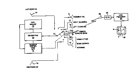
Intearated System
FIG. 10 shows an integrated system operative to
provide both æcanning beam and fixed beam guidaDce
according to this invention. The specific detailed
05 embodiment described herein is for a conventional back
azimuth or azimuth system similar to that of FIG. 1, but
having fi~ed beam precision guidance integrated thereinto,
using OCI allocated time intervals, and providing either
monitoring of the scanning beam guidance function or,
alternatively, providing for independent fi~ed beam
landing guidance for use at small airports. In FIG. 10,
an airborne receiver and data processing means is
illustrated. The azimuth ground equipment shown in FIG.
10 includes a transmitter 70 which selectively feeds, via
lS a suitable switch unit 72, multiple antennas 74 through 81
which respectively have different radiation pattern
shapes, depending on the function that each is desired to
perform. Although switch 72 is shown schematically as a
rotary switch, it would comprise an electronic switching
unit in a practical installation. The position of the
switch 72, and its dwell time at each selectable position,
is controlled by a programmed Radiation Control Logic Unit
(acLu) 7. The control unit 71 also controls whether the
transmitter 70, when connected to a particular antenna,
transmits a continuous wave output or whether it transmits
a data encoded function (for e~ample, the reference time
code or appropriate data words). Such encoding is
provided by the data encoder 73 when called for by the
RCLU 71.
The beams radiated by the various antennas provide
signals received in the air by airborne equipment which
includes an antenna 92 coupled to an airborne receiver
93. The output signals from the receiver are delivered to
PATENT
-28- lX~4~03 B02346A
an airborne data processor 94 which performs all the
programmed functions necessary to provide guidance and
which delivers guidance signals to drive guidance means.
Here, the quidance means is depicted as a guidance
05 indicator 95 which is of standard form, escept that the
glideslope needle B would be inoperative during back
azimuth usage.
The system shown in FIG. 10 provides the standard
functions comprising the currently accepted MLS system
but, in addition, can be utilized as set forth hereinafter
to provide either scanning beam guidance compatibly
combined with my novel fixed beam guidance monitoring
system or, alternatively, to provide guidance using only
my fised beam guidance system (i.e., at airports which are
small and have low traffic levels and therefore do not
require the more sophisticated flight paths that the ~ ~c
scanning beams of the full MLS system can provide~ J~ 6
As discussed previously, MLS is a very flexible
system that can be installed ir, a wide variety of
configurations, depending on the terrain at a particular
site and the traffic volume, etc. The particular detailed
MLS embodiment discussed below, with reference to FIG. 11,
was chosen as representative of a typical installation,
and also as an illustration of previous discussions within
this disclosure. The MLS system shown in FIG. 10 is
configured to provide azimuth or back azimuth scanning _
beam coverage using the beam 9' shown in FIG. 11 to
provide a precision guidance region 49 of + 10 degrees.
Beams 50 and 51 provide clearance sector beams outside
this + 10 degrees region and estending guidance to the
limits of + 40 degrees, defined by the sector 8. OCI
beams 43 and 44 provide false course the guidance limits
of ~ 40 degrees. Beams 31 and 32 provide the fised beam
precision quidance of my invention.
-29~ 4~03 B02346A
A sequence of conventional MLS beam radiation from
the ground antennas of FIG. 10 is normally as follows.
As shown in FIG. 10, a preamble is first transmitted from
antenna 74 with antenna pattern coverage corresponding to
05 ~ 40 degrees toward approaching aircraft in the guidance
region 8, as shown in FIG. 11. The preamble 11, FIG. 3,
includes an identification of the MLS function 14 being
radiated which operates in the receiver to call up the
proper processor program to process the data being
radiated within that same guidance function from the
ground installation. Sector beams 15 are then radiated
from the antenna 74, commencing with the ground
installation identification code 16 (station identity~ and
the airborne antenna selection signal 17. Then the
out-of-course OCI beams 18 are transmitted from the
azimuth antennas 75 and 76 to provide the beams 43 and 44,
FIG. 11, to warn the pilot when he is outside the guidance
region 8. The TO test pulse 19 is then radiated via the
antenna 74, followed by radiation of the left clearance
beam 50 via antenna 78, which is then followed by the TO
scanning beam 9' via the antenna 79, after which radiation
of the right clearance beam 51 occurs via the antenna 77.
After a pause, a second right clearance beam is radiated
via the antenna 77, followed by the FRO scanning beam 9~
using the antenna 79, which is then followed by radiation
of a left clearance beam 50 by the antenna 78. Radiation
of the FRO test pulse 19' via the antenna 74 terminates
the MLS azimuth guidance function.
The technique for including the radiation of my
fi~ed beam precision guidance functions in the FIG. 10 M1S
system is as follows: First, there are si~ azimuth OCI
time intervals available for radiation of OCI beams in the
present MLS specification. It is conventional to radiate
only two OCI beams 43 and 44, FIG. ll, in just two of
X~4~(~3 PATENT
`` _30_ 1 B02346A
these six intervals, leaving four unused OCI intervals
available. The present fised beam precision guidance
beams can therefore be radiated during unused OCI
intervals by programming the logic control unit 71 to
05 transmit sequentially via the switch 72 and antennas 80
and 81, my fi~ed beam precision beams having beam patterns
31 and 32 which overlap along the centerline 36, as shown
in FIG. 11. In addition, the logic control unit 71
initiates the transmission of data words and the antenna
74 and switch 75 at appropriate times in the overall MLS
radiating sequence, which data words identify the nature
of the fised beam precision function.
FIG. 12 shows the output response by an MLS receiver
and processor to azimuth MLS scanning beam guidance beam
received in response to scanning beam 9' as shown in FIG.
11. The illustrated airborne response to the MLS scanned
proportional guidance system includes a curve P of the
processor output voltage for various different angular
locations of the aircraft on both sides of the 0 degrees
centerline 36, plotted horizontally. For an aircraft
position at 0 degrees, on the centerline, the output will
be zero, meaning that the azimuth needle A of the
indicator 95, FIG. 10, will be centered. As displacement
of the aircraft off the centerline increases, the output
on curve P will linearly increase needle movement for
displacements up to 10 degrees on each side of center,
although the over-all curve is shown for deviations up to
40 degrees each side of the centerline. The response of
the FIG. 12 curve beyond the linear portion P, which is
the limit of scannin~ beam proportional coverage, is
controlled by the clearance beams 50 and Sl to provide
constant amplitude fly/left and fly/right signals PL and
PR.
PATENT
-31- lX84;~03 B0234 6A
FIG. 13 shows a curve X which is similar to curve P
in FI~. 12 in over-all appearance, but represents my fixed
beam guidance system response. Less of the contour of the
curve K beyond the centerline 36 is linear, the linear
05 portion encompassing less than about 5 degrees each side
of the centerline, for instance, for aircraft approaching
between the points 96 and 97, as shown in FIG. llA.
However, useful guidance is still given in the zones
between the 5 degrees and the 10 degrees displacements off
centerline 36. The clearance beams are also provided by
the antennas 77 and 78 of FIG. 10 to produce fly/left or
fly/right indications as shown at KR and KL, just as in
the case of FIG 12. A comparison of FIG's. 12 and 13
shows that a scaled-down system which uses only my fixed
beam guidance system, and eliminates scanning beams, gives
results which are comparable with those of the full MLS
system, and which are quite adequate for small airport
use. It is pertinent to note that the ILS landing system,
as used for many years at large airports, provides linear
guidance in its proportional display for only about 2 1/2
degrees each side of the centerline, with the needle of
the cockpit display pegged for positions beyond 2 1/2
degrees from the centerline to provide fly/left and
fly/right instructions to the pilot.
The above discussions show that the standard MLS
system, the M~S system augmented to include my fised beam
monitoring system, and the scaled-down system using my
fised beam guidance in place of scanning signals, are all
mutually compatible, and can all be interchangeably used
at airports around the world, the different systems merely
requiring appropriate programming of the ground radiation
control logic 71 and the ground data encoder 73 to
indicate which type of system is at a particular location,
and requiring appropriate programming in the airborne data
PA~ENT
--32-- 1~4~03 B0234 6A
processor 94 to cooperate with the different ground
installations. The discussions also show that my fixed
beam system, while using the same ground transmitter 70 as
the MLS system, uses different antennas and operates
05 differently and at different times in the MLS radiation
sequence, and, therefore, operates independently, to a
large e~tent, of the MLS scanning beam system when serving
to monitor the latter.
This invention should not to be limited to the exact
embodiments shown in the drawings, for obviously, changes
may be made within the scope of the following claims. For
example, it can further be noted that my invention does
not preclude the possibility, and indeed enhances the
possibility, of an MLS compatible landing system with a
signal format, as outlined in this disclosure, but
operating at another microwave frequency. For example,
such an MLS compatible system, as outlined in this
disclosure, could be implemented at a higher frequency,
such as 10,000 or 15,000 MHz, with a much smaller ground
station. Specifically, the use of MLS compatible fixed
guidance beams, at a higher freguency, would result in
such a ground system not only being smaller because of the
use of a higher frequency, but also smaller because of the
reduced size of the fised beam antennas in contrast to the
scanning beam antennas. This small size would be
particularly attractive for certain applications, such as
some unique military applications where an estremely small
ground station is vital. In the aircraft, all that would
be additionally required would be a simple fiYed frequency
converter to convert the higher frequency to the accepted
MLS frequency of about 5,000 MHz, with all other aspects
of the airborne equipement being as described in this
disclosure. In this manner, such an airborne equipment
could be utilized, not only to receive the signal from a
-33- lX84~03 B02346A
small unigue military requirement ground station, but also
the conventional 5,000 MHz MLS signal radiated from civil
airports, for e~ample. These and other variations of my
invention are intended to be within the spirit and scope
05 of the claims which follow. Thus, it should be understood
that no limitation with respect to the apparatus and
method described herein should be inferred, and all such
modifications are to be covered which fall within the
scope of the claims.
... : - ...... . ... ~ . .......... ..
,. . ~ I