Note : Les descriptions sont présentées dans la langue officielle dans laquelle elles ont été soumises.
1328684
--1-- .. . .
METHOD FOR LOCATING A RADIO FREOUENCY EMITTER
:,,,. ,. , ~- ,
BACKGROUND OF THE INVENTION
This invention relates to a method for locating a
radio frequency emitter that transmits pulses in a swept -
beam pattern.
In electronic warfare applications, the need arises
to locate a radio frequency emitter that transmits
pulses in a swept beam. Such a swept beam is usually
produced by a rotating antenna, but could also be
produced by an oscillating antenna. Current techniques¦
for locating such an emitter require that the
observation point lie in the line of eight Or the
emitter. This requirement means that an emitter can ~ :
only be located when the observation point is exposed to ;~
attack from the emitter. The accuracy of some current -
techniques for locating a radio frequency emitter also
depends upon precise angle measursments, which may be -~ -
diffiault to obtain. -
SUMMARY OF THE INVENTION .
The invention is a method for locating a radio ~ ~-
frequency emitter at an observation point that does not
have to be in a direct line of sight from the emitter by
using terrain intervisibility data and the relative
times of arrival of signals from a single pulse
,
~ ' ','., ' .
:
1 3 2 8 6 8 4
-2-
1 reflected from different points on the terrain at the
observation point. The emitter transmits pulses in a
regular swept beam pattern. As a result of this regular
pattern, the angles of transmission of the pulses can be
5 inferred. Intervisibility data of terrain points in a
region around the observation point are stored in
computer memory. At the observation point, measurements
are made of the times of arrival of a plurality of
terrain point reflections of a single pulse tr~nsmitted
by the emitter. Thege measùrements are repeated for a
plurality of pulse5 transmitted by the emitter. In a
computer, a comparison is made o~ the terrain points of
reflection calculated from the measured times of arrival
for candidate, i.e., assumed emitter locations with the
stored intervisibility data o~ terrain points. Precise
angle measurements are not required to locate a radio
frequency emitter in this way.
An a~pect of the invention i~ as follows: ~:
A method for locating a radio frequency ;~
emitter that transmits pulses in a swept beam pattern
comprising the ~tep~ of:
storing intervi~ibility data of terrain points
in a region around an ob~ervation point~
2S mea~uring at the ob~ervation point the time3
o~ arrival o~ a plurality o~ terrain point re~lections
of a single pulse transmitted by the emitter;
repeating the measuring step for a plurality
of pulses transmltted by the emitter; and
comparing terrain points o~ reflection
calculated from the measured times o~ arrival for - ~
assumed emitter locations with the stored ~ - ;
intervisibility data of terrain points.
. .
. ., , . " . ,, ; , . , ~
1328684 ~-
:: .
-3- :
1 B-R-IEF DESCRIPTION OF THE DRAWINGS
~h~ ~eatures o~ a pecl~lc embodlment o~ the best
mode contemplated o~ ~arrying .oYt the ~nv~ntio~ are
illu~a~ed ln the drawings, in which:
FI~S. 1 to 3 ar~ grams illu~trating spatlal
.; considerations used to explain th~ invention;
F~GS. 4 and 5 are w~veforms lllu~trating ~me rela-
ti~nships u~ed to explaln the invention: ~
FIG. 6 is a ~che~atic block diagram of appa~atus
i~ ~or practicing th~ invention7
FIG. 7 is a sChematic blo~X diagram that
: illustratQs th~ data used ~y a compu~er to locate an
emitter in accordan~ with t~ princlple~ of the
~n~entio~; and ...
FIGS. 8A, 8B, 8C and 8D are diagrams representing
the fea~ibili~y o~ Yarlous emitter loc~tions. ~ : `
' ' "
: .
.
~,
~: -:
:;
..
'- ' . ,'
....
1328684 :: -
.~
-4-
1 DETAILED DESCRIPTION OF THE SPECIFIC EMBODIMENT
FIG. 1 is a schematic plan view of a terrain based
emitter 10 to be located relative to an observation
point 12. It is assumed that emitter lo rotates at a
constant angular velocity of 30- per second and
transmits pulsed radio frequency waves, e.g., at 1.344
gigahertz, with a pulse repetition rate, ë.g., of 450
pulses per second. It is al80 assumed that emitter 10
has a directional radiation pattern with a narrow main
beam or lobe, e.g., ~- to 3-, and lower intensity side
lobes. It is further assumed that the altitude of
emitter 10 and observation point 12 through ground
reflections and the terrain altitude therebetween is
such that observation point 12 is not in a direct Iine
of sight from emitter 10, i.e., observation point 12 is
below the line of ~ight of emitter lo.
Observation point 12 could be a low flying
aircraft, a ground site, or a ship on water. When the
main beam of emitter 10 i6 not directed at observation
point 12, some of the radio frequency energy from the
~ide lobes reaches observation point 12 through ground
refle¢tions in a direct line, as dep~cted by the broken
llne in FIG. 1. Some of the radio frequency energy ~rom
the maln beam also reaches observation point 12 after
lateral re~lection from terrain points, such as a point
14, as depicted by the unbroken line in FIG. 1. Thus,
each pulse transmitted by emitter 10 reaches observation
- point 12 in the direct line path and thereafter reache~
observation point 12 from a number of laterally
reflective paths via various terrain points such as
- point 14. The time delays between the direct line pulse
and the reflected pulses received at observation point
12 are indicative of the specific terrain points from
which the delayed pulses are re~lected. ~he longer the
tran~mission path from èmitter 10 to the terrain point
' ' ,' . ' '',' ' ' ~ .. , ' " ' .' . . ~ .
~328684
-5-
1 of reflection and from there to observation point 12,
the longer the time delay.
By analyzing the radio frequency energy received at
observation point 12 from emitter 10, the angular
velocity at which emitter 10 rotates, its pulse
repetition rate, and its direction from observation
point 12 as a function of time can be determined.
Specifically, an extraordinarily large radio frequency
energy pulse, herea~ter called Peak of Beam (POB), is
received at observation point 12 when the main beam of
emitter 10 transmits in a direct line to observation
point 12. Treating this direct line, i.e., the broken
line in FIG. 1, as the angular reference for rotation of
emitter 10, the approximate angular position of the main
beam of emitter 10 at the time of reception of each
direct line pulse at observation point 12 can be
inferred. This pulse is, in general, detectable even
though the observer does not have direct line o~ sight
to the .emitter. Thus, assuming counterclockwise
rotation of emitter 10, after 675 pulises from POB,
emitter 10 i8 at an angle of 45 and a~ter 1350 pulses
~rom POB, emitter 10 i5 at an angle of 90~
In FIG. 2, point O represent~ observation point 12
and points El and E2 represent two emitter locations in
the same direction from observation point 12 in a
rectangular coordinate system having an I axis and a J
axis. The coordinate system is defined so point O is at
the origin and points El and E2 are on the J axis. A
given pulse transmitted when the main beam is at an
angle 3 and arriving at point O after a specified time
delay would be reflected from a terrain point Fl if
emitter 10 were located at point El and would be
re~lected from a terrain point F2 if emitter 10 were
located at point E2. Thus, for a particular angle ~
and a ~pecified time delay, there is a locus of possible
.: .
':
1328684
--6--
1 terrain point6, represented as a line 16 corresponding
to the possible emitter locations. For the particular
angle ~ and time delays there are different loci of
terrain points, shifting downward and to the right in
S FIG. 2 with increasing time delay.
In FIG. 3, a ~ingle emitter location'E i8 aS8Umed. .
The distance between point6 E and O, which'"'defines the
emitter location relative to observation point 12, is
represented by a distance E. 9 i8 the angle o~ ~he main '
beam at the time of pul~e tran6mission, I i8 one
coordinate of a terrain point of reflection, and J i8
the other coordinate of the 6ame terrain point of '
reflection. For a specific location of emitter 10,
~.e., point E, and a variable angle ~, the 10CUB of
possible terrain points from which a reflected pulse
could reach observation point 12, after a given time "~
delay relative to a directly transmitted pulse i8
defined by an elllpse, as illustrated in FIG. 2, because
the reflected transmission path~ for all such terrain
pathB are the Bame. Thus, the delayed pulses received ' '
at observation point 12 correspond to ellip~es
lncreaeing in ~ize about points 0 and E with increasing
time delay. This relationship is expressed by the
equation: '
-4 tY - r/2)2 + 4X2 - ~ 1 (1)
(r + D)Z (r + D)~ - r~ ~ -
where the difference between each reflected transmission
path, i.e., the sum of the distance ~rom point E to a
point ~I, J) and the distance from such point (I, J) to
point O, and the direct trans~ission path E equals D.
The pulse time delay, T, equals D divided by the speed ~ -
of light.
:' '~ '. '-
. ~ .
1328684
. , :. .
1 Furthermore, since the distance r equale the sum of
the distance from point 0 to point (I, J) J and the :
di6tance from point J to point E, the relation6hip among ;
I, J, E and ~ can be expressed by the following
equation:
, - .
.,. "'~
Y ~ r - X cot e (2) ~ .
:: :
From equations (l) and (2), the coordinates of a
point of reflection can be expressed in terms of the
distance r, the angle of the main beam ~ , and D, the .-~.
difference between the reflected and direct transmission ;~
paths from point E to point 0 as follows:
, -:
'' ~ ' :' :'
~: ~
~r + D/2) sin
X = l + r/D (l - cos ~)
:''',''" :'
:
.: -: .. . .
.... :- -
. ,,:
-,. . .
, .. .. .
-: :-: . .
(r + D/2) c06 ~ (4) :-:
Y r l ~ r/D (l - cos~
'''.' :''
,
-. :
..
1328684 :
-8-
1 The additional information about emitter location
that can be obtained from delay~ due to terrain
reflections for successive pulses from the emitter at
the assumed pulse repetition rate is not significant.
Therefore, only a fraction of the pulses transmitted by
the emitter are ordinarily processed in the practice of
the invention. By way of example, every 30th pulse
tran~mitted by the emitter could be proaessed. Thus,
for every 2' rotation o~ ~, a set of time delay-data is
collected.
FIG. 4 represents the directly transmitted pulses
from the emitter received at the observation point.
Large pulses 18 represent the POB pulses transmitted at
twelve second intervals. Pulses 20 represent the pulses
directly transmitted at successive angular positions of
the emitter between the POB pulses. For the assumed
emitter characteristics, 5,400 pulses 20 appear between
successive pulses 18. Each 30th pulse 20 is processed
to derive in~ormation about the emitter location during
a sampling ~nterval T, e.g., 600 microseconds, which is
less than the period between pulses 20.
FIG. 5 represent~ the radio frequency energy from a
~ingle pulse re~eived at the observation point ~rom the
emitter. Pulss 20, as before, is the directly
transmitted pulse. Pulses 22, 24 and 26 are reflections
~rom terr?in points in the region around the observation
point. A broken horizontal line 28 represents the
- threshold for discriminating between reflected pulses
and noise. The time delay between pulses 20 and 22 is
represented as Tl The time delay between pulses 20 and
24 is represented as T 2 The time delay between pulses
29 and 26 is represented as T 3. Delays Tl, l2~ and ~3
are proportional to the transmission paths from the
emitter to the observation points via the terrain point
1328684
g
1 of reflection minus the direct transmission paths from
the emitter to the observation point, i.e., r.
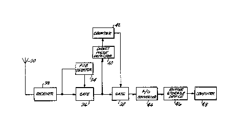
FIG. 6 illustrates apparatus for collecting and
processing the pulses from the emitter at the
observation point. The radio frequency energy is
intercepted by an antenna 30 and fed to a receiver 32,
which converts the radio frequency energy to
intermediate fre~uency. A Peak of Beam (POB) detector
34 controls a transmission gate 36~ With referen¢e to
FIG. 4, detector 34 opens gate 36 ~or the interval
between two successive POB pulses 18, during which a
total of 5,400 directly transmitted pulses pass_ from
receiver 32 through gate 36 to a transmission gate 38.
These pulses are sensed by a direct pulse detector 40
and applied to a counter 42. After every 30th pulse,
counter 42 opens gate 48 for a sampling interval T. The
resulting sample as represented in FIG. 5 is coupled to
an analog to digital (A/D~ converter 44, which digitizes
a large number of samples, e.g., 3,000 samples at
samp}ing intervals o~ 0.Z microsecond. The digitized
sample~ are collected in a buffer storage device 46.
After all the 5ample5 have been digitized they are
transferred en ma5~e to the memory o~ ¢omputer 48.
The emitter is located by comparing the time delays
of the re~lected pul~es with intervisibility data ~tored
in the me~iory of computer 48. For each terraln point
(I, J) in the region around the observation point there
are ~tored in the memory o~ computer 48 a value of
mas~ing depth, Z, i.e., the height above the terrain
polnt that is visible from the observation point. For a
description of a method for determining su¢h
intervisibility data, co-pending commonly assigned
Canadian Application Serial No. 596,151, filed April 10,
~ 1989, by R. E. Huss and R. M. Denlinger.
35 ~
'", :-. -
...
1328684 : -
--10--
1 Computer 48 compares terrain points of reflection (I, J)
calculated from the measured times of arrival of a pulse
transmitted by the emitter using equations (3) and (4)
for candidate, i.e., assumed emitter locations, r, with
the stored intervisibility data of terrain points
(I, J). From this comparison, emitter locations
corresponding to soma terrain points (I, J) c~n be
eliminated from consideration for the location of the
emitter, because of the intervisibility data at such
terrain points. For example, the masking depth at a
particular terrain point might be 60 high that a
reflection from such terrain point to the observation
point would be v~rtually impossible.
Alternatively, the masking depth at a particular
terrain point might be near zero or the terrain point
may be vi~ible fro~ the observation point so that a
pulse transm~tted from an assumed emitter location could
have been re~lected from that terrain point with the
time delay, ~, o~ the signal received at the observation
point; such an assumed emitter location is a good
candidate for acceptance as the actual emitter location.
By utilizing, in additlon, other data about the terrain
point~ ~uch a5 re~lectivity, intervislbility data
between the terrain point and the as6umed emitter
location, and ~easured time delay data to other
observation points, the evaluation of pos~ible emitter
- locations, vis-a-vis the terrain points in the region
around the observation point, can be further re~ined.
~he process is depicted functionally in FIG. 7.
Intervisibility data represented by a block 50, namely
I, J, and Z, and reflected signal data represented by a
block 52, namely D and ~ are evaluated, as represented
by a block 54. The result of this evaluation provide~ a
~easibility of candidate emitter locations at the
terrain points in the reglon about the observation
: ~ :
1~28684 ~ ~
- --1 1-- . .
1 point, as represented by a block 56. As represented by
a block 58, other data can also be evaluated to refine
the feasibility indication.
FIGS. 8A to 8D represent plots of feasibility of
various emitter locations. The feasibility (F) is indi~
cated on the vertical axis, and the terrain points of
candidate emitter locations from the observation point
(0) are indicated on the J and I axes. The feasibility
(F) for each terrain point is determined by counting the
number of reflections received at the observation point
that could have been transmitted from each terrain
point, assuming that it was the emitter location, based
on the comparison of time delays of reflected pulses
with intervisibility data. The highest value of
feasibility (F) occurs at the likely emitter location
(E~. Thus, FIGS. 8A to 8D depict a scoring function of
the possible emitter locations based on the described
comparison of the time delays of the reflected pulses
with the intervisibility data. Different measures of
scoring, i.e., evaluating these comparisons, could be
employed to further refine the feasibility data.
Reference i9 made to Appendix A for a program
listing of software for evaluaSing candidate emitter
locations in the described manner on a Digital Equipment
Corporation VAX/VMS, Version V4.6 computer.
The described embodiment of the invention is only
considered to be preferred and illustrative of the
inventive concept; the scope of the invention is not to
be restricted to such embodiments. Various and numerous
other arrangements may be devised by one skilled in the
art without departing from the spirit and scope of this
invention.
- .:
,..
,,. ' ' ' . .'.
:..: