Note : Les descriptions sont présentées dans la langue officielle dans laquelle elles ont été soumises.
. ::
:
13~2~71
METHOD OF MEASUREMENT OF_AZIMUTH
OF A BOREHQLE WHIk~_DRILLING
Backqroun~d of ~he Invention:
This invention relates to the field of borehole
measurement. More particularly, this invention relates to
the field of measurement while drilling (MWD) and to a
method of measuring the parameter of azimuth while the
drill string is rotating.
Another patent application, Canadian Serial No.
567,867, filed May 26, 1988, for an invention by Martin
E. Cobern and Richard D. DiPersio for a different system ~
for measuring azimuth while rotating is being filed contemp- ~-
oraneously herewith. Both applications are assigned to the
assignee hereof.
In MWD systems, the conventional approach is to take
certain borehole parameter readings or surveys only when
the drillstring is not rotating. U.S. Patent No.
4,013,945, owned by the assignee hereof, discloses and
claims apparatus for detecting the absence of rotation and
initiating the operation of parameter sensors for
~`~ determining azimuth and inclination when the absence of
rotation is sensed. While there have been several reasons
for taking various MWD measurements only in the absence of
drill string rotation, a principal reason for doing so for
~` ~
- .
, . ~p .
~, 133~
-2- ~ -
the drillers angles of azimuth and inclination is that
previous methods for the measurement or determination of
these angles required the tool to be stationary in order
for the null points of single axis devices to be achieved
or to obtain the averaging necessary when triaxial
magnetometers and triaxial accelerometers are used for
determining azimuth and inclination. That is, when
triaxial magnetometers and accelerometers are used, the ~;
individual field measurements necessary for determination ~;
of azimuth and inclination are dependent on instantaneous
tool face angle when the measurements are taken. This is
so because during rotation the x and y axis magnetometer
and accelerometer readings are continually varying, and
only the z axis reading is constant. (In referring to x,
y and z axis, the frame of reference is the borehole (and ,~ '~
the measuring tool), with the z axis being along the axis
of the borehole tand tool), and with the x and y axes
being mutually perpendicular to the z axis and each
other. That frame of reference is to be distinguished ~ -
... .
from the earth frame of reference of east (E), north (N)
(or horizontal) and vertical (D) (or down).
There are, however, circumstances where it is
particularly desirable to be able to measure azimuth and ; `
inclination while the drillstring is rotating. This
requirement has led to the present invention of a method :~ -
for measurement of azimuth and inclination while
drilling. Examples of such circumstances include (a)
wells where drilling is particularly difficult and any ;~
interruption in rotation will increase drill string
sticking problems, and (b) situations where knowledge of
instantaneous bit walk information is desired in order to -
know and predict the real time path of the borehole. A
system has heretofore been proposed and used for obtaining
inclination while the drillstring is rotating. The
present invention also makes it possible to obtain azimuth
while rotating.
:, ;-.,
"~ 3 2 4 7 1
- 2a -
In accordance with a particular embodiment
of the invention there is provided a method for
~ determining the azimuth angle of a borehole being
s drilled by instruments contained downhole in the
drillstring, including the steps of:
sensing with accelerometer means, during a
period of nonrotation of the drillstring, the .
!~ components of Gx, Gy and Gz of the total gravity
field Go at the location of the instrument;
sensing with magnetometer means, during a
period of nonrotation of the drillstring, the
components of Hx, Hy and Hz of the total magnetic :
field Ho at the location of the instrument;
the components Gz and Hz being along the
15 axis of the drillstring, the components Gx and the ~
components and Gy being orthogonal to Gz and the ~.
components Hx and Hy being orthogonal to Hz;
rotating said magnetometer means with said :
drillstring and obtaining the parameter Hzr which is
the Hz component of the magnetic field at the
l ~ location of the instrument during rotation of the
¦~ drillstring;
determining Ho from values Hx, Hy and Hz
sensed during nonrotation of the drillstring;
:~ 25 determining the inclination angle of the
, ; .
. ~ drillstring;
: determining the dip angle ~ of the
;:: . magnetic field;
` determining the angle 0 between the :~
direction of the magnetic field and the axis of the
drillstring at the location of the instrument from
: Ho and Hzr; and
,
.~ ,
,~ : .
~ ` :
.. :: :
' ~ '
,: .
, .,
.
~3~2~71 ~:
- 2b ~
determining the azimuth angle (A) either
from the relationship~
(A) = arc Cos Cos(0) - Cos(I) sin(~
sin(I) cos(~ )
or from the relationship ;:
tan2(A) = cos2( ~ )sin2(0) - [cos(0)sin(~ )-cos(I)]2 ,~
cos2(~)[sin2(I)-sin2(0)]+[cos(0)sin( ~ )-cos(I)]2 ` ,
In accordance with a still further parti-
cular embodiment of the invention there is provided
a method for determining the azimuth angle of a ~ ~.
borehole being drilled by instruments cont~ined
downhole in the drillstring, including the step~ of~
determining with accelerometer means,
during a period of nonrotation of the drillstring, ~: .
the total gravity field Go at the location of the
20 instrument; -~
",
determining with magnetometer means,
during a period of nonrotation of the drillstring, :;
the total magnetic field Ho at the location of the : i~:
: instrument; '
rotating said magnetometer means with said
~:~ drillstring and obtaining the parameter Hzr which is
the component of the magnetic field along the axis
of the drillstring at the location of the instrument
during rotation of the drillstringi
determining the inclination angle of the
~: drillstring; .
determining the dip angle ~ of the ! :
magnetic field;
. determining the angle 0 between the
~: .35 direction of the magnetic field and the axis of the ~ ~
: drillstring at the location of the instrument; and ~ :
: . :,'
'`' ~ ''~ :, . ..
. ; , ' :....
~ ',, ' ' ; ;;; ; . . .
- 1~32471
- 2c -
determining the azimuth angle (A) either
from the relationship:
(A) = arc Cos Cos(0) - Cos(I) sin(~ )
sin(I) cos(~ )
or from the relationship
tan2(A) = cos2( ~ )sin2(0) - [cos(0)sin(~)-cos(I)]2 ~:
. . _ _ . _ _ _ _
10 cos2(~ )[sin2(I)-sin2(0)]+[cos(0)sin(;~)-cos(I)]2 ~ .
Brief Description_of the Drawinqs
. The invention will be better understood by
an examination of the following description,
together with the accompanying drawings, in which:
FIGURE 1 is a block diagram of a known CDS
system; and
FIGURES 2A and 2B are useful for a
preliminary understanding of some
of the angles involved and the :
process employed in this
invention. ~
.,~
,:~
" ",: . ~
,~
,"
, ., ~ ~ .. ~.:
:
1332~71 -~
Description of the Preferred Embodiment:
The method of the present invention is intended to be
implemented in conjunction with the normal commercial
operation of a known MWD system and apparatus of Teleco
Oilfield Services Inc. (the assignee hereof) which has
been in co~mercial operation for several years. The known `~
system is offered by Teleco as its CDS (Computerized
Directional System) for MWD measurement; and the system
includes, inter alia, a triaxial magnetometer, a triaxial
accelerometer, control, sensing and processing
electronics, and mud pulse telemetry apparatus, all of
which are located downhole in a rotatable drill collar -
segment of the drill string. The known apparatus is
capable of sensing the components Gx, Gy and Gz of the ;~
total gravity field Go; the components Hx, Hy and Hz of
the total magnetic field Ho; and determining the tool face
angle and dip angle (the angle between the horizontal and
the direction of the magnetic field). The downhole ~
processing apparatus of the known system determines ;
azimuth angle (A) and inclination angle (I) in a known
manner from the various parameters. See e.g., the article
HHand-Held Calculator Assists in Directional Drilling
Control" by J.L. Marsh, Petroleum Engineer International,
July & September, 1982. ;:
Referring to FIGURE 1, a block diagram of the known
CDS system of Teleco is shown. This CDS system is located
downhole in the drill string in a drill collar near the
drill bit. This CDS system includes a 3-axis ~-
accelerometer 10 and a 3-axis magnetometer 12. The x axis
of each of the accelerometer and the magnetometer is on
the axis of the drillstring. To briefly and generally
describe the operation of this system, accelerometer 10
senses the Gx, Gy and Gz components of the downhole
gravity field Go and delivers analog signals commensurate
therewith to a multiplexer 14. Similarly, magnetometer 12
senses the Hx, Hy and Hz components of the downhole
~..... ..
,' 1~ , . :''
--4--
magnetic field. A temperature sensor 16 senses the
downhole temperature of the accelerometer and magnetometer
and delivers a temperature compensating signal to
multiplexer 14. The system also has a programmed
microprocessor unit 18, system clocks 20 and a peripheral
; interface adapter 22. All control, calculation programsand sensor calibration data are stored in EPROM Memory 23.
Under the control of microprocessor 18, the analog
signals to multiplexer 14 are multiplexed to the
analog-to-digital converter 24. The output digital data
words from A/D converter 24 are then routed via peripheral
interface adapter 22 to microprocessor 18 where they are
stored in a random access memory (RAM) 26 for the
calculation operations. An arithmetic processing unit
(APU) 28 provides off line high performance arithmetic and
a variety of trigonometry operations to enhance the power
and speed of data processing. The digital data for each
of Gx, Gy, Gz, Hx, Hy, Hz are averaged in arithmetic
processor unit 24 and the data are used to calculate
azimuth and inclination angles in microprocessor 18.
These angle data are then delivered via delay circuitry 30
to operate a current driver 32 which, in turn, operates a
mud pulse transmitter 34, such as is described, for
example, in U.S. Patent 4,013,945.
In the prior art normal operation of the CDS system,
the accelerometer and magnetometer readings are taken
during periods of nonrotation of the drill string. As ;
many as 2000 samples of each of Gx, Gy, Gz, Hx, Hy and Hz
are taken for a single reading, and these samples are
averaged in APU 26 to provide average readings forieach
component. A procedure has also previously been
implemented to determine inclination (I) while the drill
string was rotating. In that procedure, the Gz component
of the gravity field is determined from an average of -~
: . :~ ~,
:
~ 1332~71 ~ ~;
-5-
samples obtained while rotating, and the inclination angle ~
(I) is determined from the simple relationship ;
tan(I) = V Go2 - Gz~ (l)
Gz
where Go is taken to be lG (i.e., the nominal value of
gravity). This system is acceptable for measuring
inclination while rotating, because the z a~is component
Gz is not altered by rotation. ~ ;
In accordance with the present invention, the
parameter of azimuth angle (A) is now also obtained while ~ ~
rotating. Before discussing the specifics of the azimuth ~ -
measuring technique, reference is made to FIGURES 2A and
2B for a preliminary discussion of some of the angles
involved and the process employed in this invention. .~:
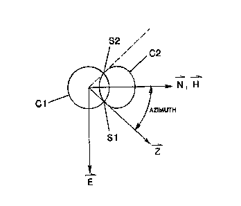
Referring first to FIGURE 2A, the orthogonal directions
east (E), north (N) and down (D) (or vertical) are shown.
The axis of the borehole and of the tool in the borehole
is indicated as Z. The inclination angle I is the
included angle between the Z a~is and the D a~is.
However, without knowing azimuth, the direction of I is
undetermined; all one knows about the measured inclination
angle is that it is an angle of a certain magnitude, and
its direction may lie anywhere on the surface of an
imaginary right circular cone of half angle (I) about the
D direction. That imaginary cone is indicated at Cl.
Dip angle (i.e., the angle the direction of the magnetic
field Ho makes with the horizontal) can be determined from
measured parameters (see Eq. 6 below). An angle 0 ,
which is the angle between the direction of Ho and the Z
, 1 30 axis, is defined by this invention. The angle 0 has not
heretofore been used in determining azimuth. A second
imaginary cone C2 is defined which is a r~ght circular
cone of half angle 0 about the direction of Ho. Cone
C2 intersects cone Cl at two lines Sl and S2, which
represent two solutions to the final equation (Eqs. 7 or ~ -
8) used in the process of this invention. FIGURE 2B shows
, ~:
.,
:
:::
::
~ 3~
-6-
the cones Cl and C2 of FIGURE 2Aprojected into the
horizontal plane. As seen in FIGURE 2B, cone Cl
projects into a circle around the D a~is (into the plane
of the paper at the center of Cl), and cone C2
projects into an elipse around the north (N) axis which
intersects Cl at the two locations Sl and S2. From
FIGURE 2A it can be seen that the following relationships
e~ist:
Gz = Go Cos(I); or Cos(I) = Gz (2)
10 Go
Hz = Ho Cos(0 ); or Cos( 0) = Hz (3)
Ho
In the method of the present invention, measurements :~
of Gx, Gy and GZ and Hx, Hy and Hz are taken during each
period of nonrotation, and the most recent set of those
measurements is stored in RAM 26. When it is desired to
obtain an azimuth reading while rotating, microprocessor
18 proceeds to determine GO and Ho from the relationships
Go = VGX2 + GY2 + GZ2 (4) .
and
Ho = V Hx2 + Hy2 + Hz~ (5)
where Gx, Gy, Gz, Hs, Hy and Hz are the most recent
nonrotative values in RAM 26. Then, real time readings
while rotating are taken of Gz and Hz. As in the
nonrotating case, a large number (typically 2000-4000) of ~ ~.
instantaneous readings are taken over about lO seconds,-~ ~ :
and they are averaged to get real time values of Gz and
Hz. For Gz the averaging reduces or eliminates the :~
effects of axial vibration on each instantaneous :;~
measurement of Gz. These real time values are then ~ .
delivered to microprocessor 18 where the inclination (I) ~ ~:
is determined from equation (2) ~:
Cos(I) = Gzr :. .;:~
Go
where Gzr is the value of Gz measured while rotating and
`- ~3~
--7--
Go is determined by equation (4) from the most recent
stored nonrotating values of Gx, Gy and Gz.
Alternatively, (I) can be determined from equation (1)
tan(I) -~Go2 - Gzr
Gzr
Also, the angle 0 is determined in microprocessor 18 from
equation (3) ~-
cos( 0) = Hzr
Ho ;
where Hzr is the value of Hz measured while rotating and
Ho is determined by equation (5) from the most recent
stored nonrotating values of Hx, Hy and Hz.
The angle 0 can also be determined from
tan(~) =VHO2 - Hzr2 3(A)
Hzr
The dip angle (;~) is also calculated by microprocessor 18
from the relationship
= arc sin Gx Hx ~ GY HY + Gz Hz (6)
Go Ho
20 where G~, Gy, Gz, Hx, Hy and Hz are the most recent stored
nonrotative values and Go and Ho are determined from -
equations (4) and (5), respectively.
Next in the process, the azimuth angle (A) is -
calculated by microprocessor 18 from the relationship
(A) = arc Cos Cos~G~) - Cos(I)sin~ ) (7)
sin(I) cos(~ )
; The real time values of both inclination angle (I) and~ ~;
azimuth angle (A) are transmitted to the surface by
transmitter 30 for use and processing at the surface by
the driller and others.
Since cos(0 ) = Bz and Cos(I) = Gz, equation (7) can also be ;
Bo Go
written as ;
A = arc Cos GoBz - BoGz sin ~ 7(A)
Bo cos (GoZ - GZZ)1/2
{
'
1332471
-8-
Rather than calculating the dip angle from equation
(6), the value of ~can be determined from relevant charts
and stored in the memory. Also, while the method of this
invention has been described in terms of downhole
calculations from the measured data, it will, of course,
also be understood that the measured data Gx, Gy, Gz, Hx,
Hy, Hz can be transmitted to the surface and the
calculations done there. It will also be understood that
all steps and calculations may be carried out under the
program control of microprocessor 18 by means of any
suitable program within the ordinary skill in the art or
by modifications to the already existing program for
operation of the CDS system, such modifications being ~-~
within the ordinary skill in the art.
As an alternative to determining azimuth angle (A)
from equation (7), it may be determined from the
relationship ~
tan2(A) = cos2(,:~)sin2(0 ) - ~cos(0 )sin(;1)-cos(I)]2 ~-,. ':
cos2(~ )tsin2(I)-sin2(0 )]+[cos( 0)sin(~ )-cos(I)]
In both equations (7) and (8) the value for (I) may be
either the value determined from the most recent ~
nonrotating survey or the real time value measured while ~;
rotating. In cases of difficult drilling conditions
(e.g., high axial vibrations) where the z axis
accelerometer may be saturated, the value of (I) ~ ~;
determined from the most recent nonrotating survey would
preferably be used; otherwise it is preferable to use the
real time value determined while rotating.
It is to be noted that there are two solutions to each
of equations (7) and (8). There is enough information to
determine the magnitude of the azimuth angle, but not its
sign. In most cases, this will not be a problem, since
the angle will change only slightly from the most recent
value determined while nonrotating. Ambiguity in sign
: ' '.~ .
-9- ~ :
will occur only when the drilling is close to the north or
south.
While preferred embodiments have been shown and
described, various modifications and substitutions may be
made thereto without departing from the spirit and scope
of the invention. Accordingly, it is to be understood
that the present invention has been described by way of ;
illustrations and not limitation.
What is claimed is: ~
, :'
''