Note : Les descriptions sont présentées dans la langue officielle dans laquelle elles ont été soumises.
-- i 20~3~9
,,
FIELD OF THE INVENTION
The present invention pertains to systems which are useful
~ for mapping and characterizing the contamination levels within
,~ a preselected site location. More particularly, the present
; invention pertains to a site characterization system which uses
6 the Global Positioning System (GPS) satellites to precisely
, locate each particular point within the selected site location
~;~ 8 at which a contamination level reading is taken. The present
invention is particularly, but not exclusively, useful for
obtaining numerous contamination level readings within a very
large topographical area.
12
~- 13 BACKGROUND OF THE INVENTION
Under most circumstances, it has become increasingly
I obvious that the environmental impact of contamination, in any
16 of its many and varied forms, is simply unacceptable. In some
cases, the location and identification of the particular
~ 18 contamination is readily apparent. In others, the location and
2;``~ 19 ~ dentLfication of the contamination can pose a problem. In any
20~ eyent, the necessary objective is to decontaminate the affected
;~c~ 1 area in some way. Unfortunately, with advances in technology,
22 it is not now uncommon for vast areas to be contaminated or
2~ polluted by highly dangerous nuclear or toxic materials.
24 Furthermore, the problem of locating contamination is not
2; lessened merely by the fact an extensive area is involved.
Z Indeed, this fact may aggravate the problem.
26
,~: . -1-
~ 20~ 53~9
1l ~
Various detectors have been proposed for use in
~ determining the nature and concentration level of a contaminant
:3 or pollutant. Typically, however, they do not provide direct
4 information on the location of the contamination. Instead,
. such information is obtained from maps or some other geound-
. based reference syste~. Unfortunately, these references can be
_ inaccurate. This is particularly so when the contamination is
8 airborne or waterborne and dispersed throughout a very large
9 area. Moreover, even after an initial clean up has been
accomplished, it is possible for there to be residual
contamination, and in such cases it may be necessary to retrace
12 paths over an extended area in order to determine the location
13 of any residual contamination. Also, it is possible that the
14 contamination is not just superficial. In such cases it may
E~ also be important to be able to bore into the surface of the
16 earth and locate the point of contamination. Again, knowledge
1~ of the precise topographical location is important.
18 An example of an automated system which is designed to
19 ~ continuously link exact survey positions with field monitoring
lnformation is the ultrasonic ranging and data system (USRADS)
2i which has been developed by Martin Marietta Energy Systems,
22 Inc. in cooperation with the U.S. Department of Energy. The
2~ USRADS system incorporates a series of receivers on the
24 perimeter of the particular site to be characterized and uses
the differences in arrival times of ultrasonic pulses from the
detector point to determine the exact location of the detector
26
-2-
~ ~ V 1 ~ ~ 0 9
within the site area. This data is transmitted to a nearby
~> microcomputer which calculates and records the position of the
:~i detector along with corresponding survey data. Such a system,
4 however, requires ground-to-ground data links and,
; consequently, is susceptible to interference from ground
6 clutter and obstacles. Further, such a system is somewhat
. limited in that the peripheral receivers are essentially
8 stationary and must be appropriately positioned for the conduct
of the survey. Accordingly, they may not lend themselves to
1(~ coverage of a very large area wherein there is rugged
topography.
12 The present invention recognizes that a site
13 characterization system can be employed which does not rely
14 solely on ground references for precisely locating the
1; surveyor's exact position within the area at the time a
16 contamination reading is taken. More specifically, the present
17 invention recognizes that a site characterization system using
18 position information from a GPS satellite will allow for mobile
~ 19 operation of a detector within a preselected site.
1~ In light of the above, it is an object of the present
2~
~a; 21 invention to provide a site characterization system which gives
80- 22 reasonably accurate topographical information on the location
` ~ where a contamination reading is taken within the area of a
, ~
24 preselected site. Another object of the present invention is
to provide a site characterization system which allows for the
Z characterization of contamination and pollution levels over an
26
-3-
I ~
20~6309
extended area. Yet another object of the present invention is
~2 to provide a site characterization system which can incorporate
~ a mobile base station and a plurality of mobile on-site
4 stations in order to enhance the flexibility of the system in
; characterizing a particular selected site. Another object o
the present inventioh is to provide a site characterization
system which is compatible with various detectors for
8 determining the respective levels of different contaminants.
9 Still another object of the present invention is to provide a
lo site characterization system which provides accurate site
characterization within a relatively short period of time.
12 Still another object of the present invention is to provide a
13 site characterization system which allows characterization of
14 the site in situ without having to extract or remove samples
1~. from the site for the conduct of laboratory tests. Yet another
16 object of the present invention is to provide a site
17 characterization system which can generate timely and accurate
~; 18 remediation reports based on waste site characterization
19 ~results and the applicable regulatory requirements. Finally,
another object of the present invention is to provide a site
21 characterization system which is easy to use, relatively simple
22 , to manufacture and comparatively cost-effective in its
R 28 employment.
aO~ 24
26
J~l
2~30~
1 SUMMARY OF THE INVENTION
A preferred embodiment of the novel GPS satellite
3 constellation referenced site characterization system includes
4 a base station which is established for the collection and
s recordation of data, for directing field operations, and for
6 generating waste sit~ characterization and remediation needs
, reports. A plurality of mobile on-site stations are also
8 provided for movement throughout the area of the site to be
9 characterized. Each of the on-site stations includes at least
one detector for determining the contamination or pollution
il level at a selected point within the site area and also
~ 12 includes a transceiver for transmitting a signal to the base
`~ l3 station which is indicative of the contamination level at the
14 particulae selected point within the site area. Further, the
detector at any particular on-site station may include a probe
16 which is able to bore into the earth's surface to determine
subsurace contamination levels in the area of the site to be
~ 18 characterized. Additionally, the detector may have a probe
5,~ ~ 19 ~ which is able to record contamination levels at predetermined
altitudes in the atmosphere above the on-site station. In any
ev*nt, the detector and its associated apparatus for analyzing
22~ the sample permit in situ characterization of the contamination
23 or pollution.
Y~Each on-site station also includes a transceiver for
x~ 24
~3~ 25 receiving signals from the GPS satellite constellation to
26 establish the spatial position of the on-site station relative
:'
; ~ ' _5_
, ~ . ,, ~
I i,,~,,,.` ,,,
I ~
` 20~6309
i
to the satellite in the constellation and, hence, the
, topographical location of the on-site station within the site
to be characterized. This signal, which is indicative of the
topographical location of the on-site station, is transmitted
to the base station where the on-site station location is
h correlated with the contamination level data collected at the
_ location. The transceiver at the on-site station can also
8 include voice and data transmission capabilities for direct
communication with the base station.
10The base station itself also includes a transceiver which
11receives signals from the GPS satellite constellation for the
17purpose of determining the spatial position of the base station
13relative to the satellite in the constellation. The base
station may further include electronic apparatus to refine the
1~;topogeaphical location of each of the on-site stations.
16Specifically, for this purpose, the apparatus interrelates the
~ 1-respective signals that indicate the topographical locations of
1~ ~ the base station and each of the on-site stations relative to
18
the GPS satellites.
20The base station also includes apparatus for combining
information concerning the topographical location of a
2~particular on-site station with the data concerning
2~contamination levels at that location. The information and
_ data is then used to compile site characterization and
,~.remediatlon needs reports. In accordance with the present
Z invention, a plurality of on-site stations may be provided for 26
-6-
.~......... .. . .......
~t `: . :
~ i ~ O 1 6 3 0 9
.
l simultaneously determining contamination and pollution levels
2 at various sites or at various locations within the area of a
~ single site to be characterized. Further, the on-site
4 stations, as well as the base station may be mobile in order to
; provide flexibility for the system and increase the speed with
6 which data can be collected.
_ The novel features of this invention, as well as the
8 invention itself, both as to its structure and its operation,
9 will be best understood feom the accompanying drawings, taken
in conjunction with the accompanying description, in which
similar reference characters refer to similar parts, and in
12 which:
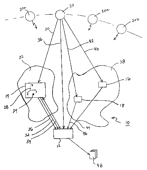
BRIEF DESCRIPTION OF THE DRAWINGS
l3
l4 The figure is a schematic diagram of the site
~ 15 characterization system in accordance with the present
;~ 16 invention indicating the flow of information between various
~ stations in the system.
,,~
`;~ l8
~; DESCRIPTION OF THE PREFERRED EMBODIMENT
- l9
Referring to the Figure, a system for waste site
~ 2l ~ characterization is shown and generally designated 10. As
`~ 22~ ~ shown, the system 10 comprises a base station 12 and at least
23 one on-site statlon 14. There may, however, be numerous other
24 on-site stations of which the on-site stations 16 and 18 shown
2S in the Figure are exemplary. As envisioned for the present
; Z invention, system 10 also incorporates and interacts with the
26
-7-
1 ~
l '~
; . , .
:~ -- ~ 20~309
...~
Global Positioning System (GPS) satellite constellation which
includes the representative satellites 20, 20a, 20b and 20c
~ shown in the Figure. For simplicity, further discussion of the
4 interaction between satellites in the GPS constellation with
. base station 12 and on-site station 14 will focus on satellite
fi 20. It is to be appreciated, however, that references to
, satellite 20 pertain equally to the satellites 20a, 20b and 20c
8 and, indeed, the appropriate signals are generated simul-
9 taneously from these satellites. It will be appreciated by the
lo skilled artisan that for time and position data, to properly
ll establish a ground-based location, the ground-based location
l2 must communicate with as many satellites as there are variables
l3 in the position data (i.e. the variables x, y, z and time).
The proper operation of system 10 relies on its ability to
precisely establish the topographical locations of the on-site
16 stations 14, 16 and 18 and use data collected by these stations
for waste site chaeacterization. It is known that satellite
18 referenced locations can be determined with great accuracy.
-~ l9 Therefore, system 10 uses a satellite 20 which is preferably a
Global Positioning System (GPS) satellite that can be accessed
~è 2l by commercial entities. Such a satellite referencing system is
22 presently available and is provided by the Block II Satellites
23 that are now being launched.
24 Turning foc the moment to a specific consideration of the
2s on-site station 14, it is to be appreciated that this station
26 14 includes a detector, or detectors (not shown). Importantly,
. :'
-8-
.,~,.,. .,. ,.. ,. , .. .. , . ,.. . ~ . .... . .... . . .
20:~6309
the detectors which are used at on-site station 14 should be
able to identify and quantify nuclear waste, such as low level
rad waste (LLRW) and tranuramic waste (TRU), as well as
hazardous toxic chemical waste products. Further, the
; detectors at on-site station 14 should be individually or
6 collectively able to sample material whether it be located on
the surface of the earth, in the air, or buried subsurface.
8 These detectors should also be selected for their ability to
determine the contamination level and analyze the contaminant
in situ without having to extract and remove the sample being
1l measured from its natural location.
`~ l2 In the operation of the system 10, a site 22 is selected
13 for characterization and the mobile on-site station 14 is moved
into the area of site 22 to a position where it can measure the
-~; c~ntamination level at a preselected point 24. The detector
:~
16 ~ (not shown) at on-site station 14 then measures the
contamination level at polnt 24, and this information is
l8`~ ~transmitted to the base station 12 as indicated by the arrow
l9~; ~ 2~6.~ Simultaneously, position data concerning the location of
point 24 in site 22 relative to an earth-based coordinate
~9~ 21 reerence 28 is sent to the base station 12. More specifi-2~ cally, the position data of point 24 is included in a signal
that is eeceived from the GPS satellites 20, 20a, 20b and 20c
2~
2~ by a transceiver (not shown) at on-site station 14, and then
relayed by the transceiver to base station 12. The flow of
~Z this signal is shown in the Fiqure by the arrow 30 which
26
_9_
l ,~
.~ .
., ~
~J
j ^ . . `~ 20~3~9
I indicates a transmission from GPS satellites 20 to on-site
station 14 and by arrow 32 which indicates the relay of this
signal from on-site station 14 to the basé station 12. In
accordance with the above-described flow of information, both
~ contamination level data and position data are provided at base
6 station 12 for subseq~ent use.
, An arrow 34 is shown in the Figure connecting base station
8 12 with on-site station 14 to indicate a communications
9 capability between the two stations. This capability is
provided by transceivers at the respective stations which allow
base station 12 to direct the field operations of the on-site
l2 station 14. The communication capability also permits
l3 cooperation between stations to increase the flexibility of
14 system 10 and to refine the data being transmitted from on-site
E; station 14 to base station 12.
l6 The Figure also shows an arrow 36 which represents a data
link between the satellites 20 and the base station 12.
18 Speclfically, this link is established to obtain position data
l9 information concerning the position of base station 12 relative
to GPS satellites 20 and, hence, the topographical location of
2i base station 12. Importantly, with position data available at
22 base station 12 for both base station 12 (i.e. arrow 36) and
2:~ on-site station 14 (i.e. arrows 30, 32), the exact topo-
24 graphical location of on-site station 14 can be refined.
SpecifLcally, the Eagle VIII Real-Time Differential (RTD)
26 System marketed by Motorola Inc. correlates signals from the
-10-
i -- 20~3~9
GPS satellite constellation with a plurality of earth-based
~ stations to obtain positional accuracies for the earth-based
:~ stations which are within the range of two to five (2-5)
4 meters.
As shown in the Figure, it is possible for system lO to
. simultaneously characterize multiple sites. For instance, site
. 22 can be in the process of being surveyed by on-site station
8 14 while, at the same time, site 38 is being surveyed by on-
9 site stations 16 and 18. In all important respects, the on-
site stations 16, 18 are similar to on-site station 14.
ll Specifically, each of the on-site stations 16, 18 has a
l2 detector (not shown) and transceiver (not shown) which perform
l3 the same functions disclosed for similar components discussed
14 above with respect to on-site station 14. More specifically,
: the arrows 40 and 42 respectively indicate the transmission of
6 pooition data signals from GPS satellite 20 to on-site stations
l7~ ~ 16, 18. These signals, together with contamination level data
18 and communlcation data, are passed from the on-site stations
l9 ~16, 18 to base station 12 over the transmission links indicated
20~ : in the Figure by arrows 44, 46.
21 With the collection of data from on-site stations 14, 16
22 ! and 18, and the ability to communicate with these stations to
direct their field operations, base station 12 is able to
23 charaaterize the sites 22 and 38. As can be appreciated, this
~25 entails taking the position data concerning the topographical
location of selected points (e.g. point 24) within the areas of
26
-11-
::
~'` ` :~ `' . ~ :.;.::
`1 , . r~ ,~
` ~ 20~3~9
s
~9
the sites 22 or 38, and correlating this position data with
~ contamination level data measured at the selected point. The
:3 compilation of this correlated data, together with applicable
regulatory requirements, results in a site characterization and
remediation needs report 48 which is useful for quarantining
contaminated areas . and directing subsequent clean-up
_ operations.
8 In summary, system 10 comprises a base station 12 which is
9 established to correlate and compile data received from various
on-site stations 14, 16, 18, and to publish a site
1l characterization and remediation needs report 48. This report
l2 48 necessarily includes information concerning both the level
l3 and nature of contamination at a preselected point 24 in a site
l4 22, and the topographical location of this point 24. The
information concerning the level and nature of the
l6~ contamination at point 24 is developed in situ at the on-site
17: stations 14, 16, 18 and then transmitted directly to base
l8 station 12. The information concerning the topographical
l9 ~ ~ loeation of point 24 is acquired by signals which originate
20~ ~ from a GPS satellite and which are received and then relayed by
2l the on-site stations 14, 16, 18 to base station }2. As
22 discussed above, a separate signal from the ~,PS satellites to
base station 12 can be used to refine the topographical
24 location information that pertains to selected points, such as
2S the point 24.
26
-12-
'~
J
~1
~ IWhile the particular integrated automated system for waste
¦ ~site characterization as herein shown and disclosed in detail
:3 is fully capable of obtaining the objects and providing the
4 advantages herein before stated, it is to be understood that it
.s is merèly illustrative of the presently prefeered embodiments
: ()of the invention and~that no limitations are intended to the
details of construction or design herein shown other than as
8 defined in the appended claims.
:~
:
"
. 1'
~ 12
. .~
~: 13
:~ 14
. ~
16
~ 17
`~ 18
::~:
~:~: i9
:
``~9 21
~U
26
.: -13-
`:::
... ~ ~ .