Note : Les descriptions sont présentées dans la langue officielle dans laquelle elles ont été soumises.
2~52~5
01METHOD OF LAYER STRIPPING
02TO DETERMINE FAULT PLANE STRESS BUILD-UP
03
04FIELD OF THE INVENTION
05
06 The present invention relates generally to geophysical
07 analysis of the subsurface of the earth. More specifically,
08 this invention provides a method for reliably and accurately
09 applying a layer stripping technique to determine fault
plane stress build-up.
11
12 BAC~GROUND OF THE INVENTION
13
14 Shear wave (S-Wave) seismic exploration techniques have
historically employed shear wave seismic sources and shear
16 wave seismic receivers in a seismic survey to gather seis~ic
17 data. Such a seismic survey has been either linear or areal
18 in its extent. The seis~ic energy imparted by the shear
19 wave seismic source is detected by the shear wave seismic
recèivers after interacting with the earth's subterranean
21 formations. Such seismic surveys, however, until recently
22 have been limited to utilizing a shear wave seismic source
23 having a single line of action or polarization, oriented
24 with respect to the seismic survey line of profile, to
preferentially generate seismic waves of known orientation,
26 e.g., horizontal shear (SH~ waves or vertical shear (SV)
27 waves. The shear wave seismic receivers utilized in
28 conjunction with a given shear wave seismic source have
29 similarly been limited to a single line of action oc
polarization, oriented with respect to the seismic survey
31 line of profile, to preferentially receive a single
32 component of the seismic wave, e.g., (SH) wave or (SV) wave.
33 As used herein, the t~rm "line of action" generally
34 comprehends a defined vector displacement, such as the
2 2Q~5~:15
01 particle ~otion of the seismic wave. In present shear wave
02 seismic surveys, the lines of action of the seismic source
03 and the seismic receivers usually have the same orientation
04 relative to the line of profile and if so are said to be
05 "matched".
06
07 The term "polarlzation" in the context of seismic waves
08 refers to the shape and spatial orientation of particle
09 trajectories. Here we restrict the term to mean only the
spatial orientation o the line along which a particle ~oves
11 in a ~inearly polarized wave. Hence ~polarization~ and
12 "polarization direction", as used here, both imply the
13 spatial orientation of such a line, the latter term
14 emphasizing the restriction to linear rather than more
lS general (e.g., elliptical) motion. A ~polarization change",
16 then, does not mean a change, for example, from linear to
17 elliptical motion nor a polarity reversal but only a chanqe
18 in the spatial orientation of the line along which a
19 particle moves.
21 As long as seismic surveys were limited to seismic sources
22 and seismlc receivers having a compressional ~P) wave lines
23 of action, satisfactory results were generally obtained
24 irrespective of the orientation of the seismic survey line
of profile with respect to the underlying geological
26 character of the subterranean formations. However, when the
27 seismic sources and seismic receivers are of the shear wave
28 type, i.e., either horizontal shear (SH) wave or vertical
29 shear (SV) wave, the orientation of the seismic survey line
of profile and/or the line of action of the shear wave
31 seismic source with respect to the geological character of
32 the subterranean formations can determine whether or not
33 meaningful seismic data is obtained.
34
2Q~L ~215
--3--
01 As understood by those skilled in the art, compressional (P)
02 waves are longitudinal waves where the particle motion is in
03 the direction of propagation. Shear waves are transverse
04 waves where the particle motion is in a transverse plane
05 perpendicular to the direction of propagation. Two special
06 classes of shear waves are defined herein. Specifically,
07 horizontal shear (SH) waves where the particle motion in the
08 transverse plane is further restricted to be perpendicular
09 to the line of profile of the seismic survey ~i.e.,
horizontal) and vertical shear (sv) waves where the particle
11 motion in the transverse plane is further restricted to be
12 perpendicular to the horizontal shear (S~) particle motion.
13
14 As the orientation of the seismic survey line of profile
is dependent on the geological character of the subterranean
16 formation, when matched shear wave seismic sources and shear
17 wave seismic receivers are used, it is known by those
lB skilled in the art that shear wave seis~ic surveys are
19 adversely affected by azimuthally anisotropic subterranean
form~tions. Azimuthally anisotropic subterranean formations
21 are likely to have vertical planes of symmetry. Because
2a shear wave behavior is complicated and generally
23 uninterpretable when the symmetry planes are neither
~4 parallel to nor perpendicular to the line of action of the
shear wave, care must be taken to ensure th~t the seismic
26 survey line of profile is laid out either parallel or
27 perpendicular to the symmetry planes.
28
29 When the seismic survey line of profile is laid out either
parallel or perpendicular to the symmetry planes, the
31 utili2ation of matched sets of (SH) wave and (SV) wave
32 seismic receivers and seismic sources have provided useful
33 information regarding-the geological character of a
34 su~terranean formation. Such a technique requires prior
2~ 215
--4--
01 knowledge of the seismic velocity anisotropy of the
02 subterranean formation to be successful.
03
04 The interaction differences of (SH) waves and ~SV) waves
05 have been utilized to detect and measure the anisotropic
06 properties of an azimuthally anisotropic subterranean
07 formation when the seismic lines of profile are properly
08 oriented with respect to the symmetry planes and matched
09 sets of shear wave seismic sources and shear wave seismic
receivers have been deployed in the seismic survey. In such
11 applications, (SH) and (SV) shear wave seismic sources and
12 seismic receivers are utilized, but only in matched sets,
13 i.e., (SH~ shear wave seismic sources with (SH) shear wave
14 seismic receivers and (SV) shear wave seismic sources with
~SV) she~r wave seismic receivers. However, if the seismic
16 survey line of profile is not properly oriented with respect
17 to the planes of symmetry, the seismic information observed
la can be difficult to interpret at best.
19
The orientation of the seismic survey line of profile with
21 respect to the symmetry planes is critical. Consequently,
22 utilization of matched sets of shear wave seismic sources
23 and shear wave selsmic receivers have produced inconsistent
24 results when the seismic survey line of profile has not been
properly laid out with respect to the anisotropic geological
26 character of the subterranean formations.
27
2B ~hose acqu~inted with the art of seismic exploration,
29 especially in seismically virgin territory, realized that
prior knowledqe of the geological character of the
31 subterranean formations and associated fault plane stresses
32 is generally not available prior to seismic exploration.
33 The method and system of geophysical exploration of the
3~ present invention can be advantageously employed without
~5~ 20~215
01 regard to or knowledge of the geological character of the
02 subterranean formations and stlll obtain meaningful seismic
03 data.
04
05 U.S. Patent No. 3,302,164 relates to seismic exploration for
06 detecting fluids in formations by obtaining a ratio of the
07 velocities of shear waves and compressional waves along a
08 selsmic line of profile. In order for the ratio to be
09 obtained, however, the frequency spectra of the waves
introduced by a seismic source had to be controlled
11 according to the average velocity ratio expected to be
12 encountered. An article, "Combined Use of Reflected P and
13 SH Waves in Geothermal Reservoir Exploration, n Transactions
14 of Geothermal Resources Council, Volume 1, May 1977,
discussed tests made using both compressional and shear
16 waves in exploring for and evaluating geothermal reservoirs.
17
1~ U.S. Patent No. 4,286,332 relates to a technique of
19 propagating seismic shear waves into the earth from
2Q compressional wave producing vibrators. U.S. Patent
21 No. 4,242,742 describe~ a technique of obtaining shear wave
22 seismic data from surveys where impact de~ices for waves are
23 used as a seismic energy source.
24
S-wave birefringence, a property of elastic waves in
26 anisotropic solids, is com~on for S-waves traveling
27 vertically in crustal rocks. Early models of anisotropic
28 sedimentary rocks proposed by exploration geophysicists were
29 often transversely isotropic with vertical infinite-fold
symmetry axes. Such solids are not birefringent for S waves
31 with vertical raypaths. Earthquake seismologists (e.g.,
32 Ando et al., 1983; ~ooth et al., 1985), however, found
33 near-vertical S-wave birefringence in earthquake data in the
34 early 1980s. At the same time, oil companies recording
-6- ZO~215
01 three-component ~3-C) seismic data independently found
02 vertical birefringence in hydrocarbon-bearing sedimentary
03 basins. (winterstein). Researchers from Amoco, Exxon,
04 Chevron and Colorado School of Mines documented this
05 vertical birefringence for the first time publicly in 1986
06 at annual meetings of the EAEG and SEG (e.g., Alford, lg86;
07 Willis et al., lg86; Becker and Perelberg, 1986; Frasier and
0~ Winterstein, 1986; Martin et al., 1986). Since then much
09 additional evidence for vertical birefringence in
sedimentary basins has accumulated (e.g., Squires et al.,
11 1989);
12
13 A common model foc vertical S-wave birefringence is
14 extensive dilatancy anisotropy (EDA) proposed by Crampin
et al. (1984). The essential feature of this model is that
16 horizontal stresses such as those from plate tectonics
17 create vertically oriented, fluid filled cracks or
lB microcracks which cause anisotropy that, unlike transverse
19 isotropy with a vertical axis, will cause vertical S-wave
birefringence. The validlty of EDA as an explanation for
21 vertical birefringence is not established, but it and
22 variants of it have proved useful as a framework within
23 which to record and interpret experimental data. An
24 alternate model, which we call the Nur model ~Nur, 1971;
Nur and Simmons, 1969), proposes the unstressed rock is
26 isotropic with a unifsrm distribution of randomly oriented
27 cracks. ~xial stresses preferentially close the cracks
2~ perpendicular to stress directions, making the rock
29 anisotropic. It is almost certain, whatever the best model
proves to be, that much of the observed vertical S-wave
31 birefringence results in some way from horizontal stresses.
32 Crampin and Bush (19~6) also pointed out that vertical
33 S-wave birefringence might provide a useful tool for
34 reservoir development. ~he polarization direction of the
20~Z15
01 fast S wave in simple cases gives the direction of maximum
02 horizontal compressive stress, a quantity much in demand by
03 those who induce fractures in reservoirs by techniques such
04 as hydraulic fracturing.
05
06 Available evidence, (discussed later), including offset VSP
07 information supports the notion that the vertical S-wave
08 birefringence is caused by horizontal stresses, and that the
09 polarization direction of the fast S wave lies in the
direction of maximum horizontal compcessive stress, even
11 when subsurface structures are steeply dipping. It is
12 likely however that rocks exist for which the polarization
13 direction of the fast S-wave for vertical travel does not
14 lie along the maximum horizontal stress direction. Rocks
with fractures oriented by ancient stress regimes, or rocks
16 f low symmetry with tilted symmetry axes, for example,
17 might constrain the fast S-wave polarization to lie in a
18 direction other than that of maximum horizontal stress.
19
Unmistakable evidence is hereby presented for major changes
21 in S-wave polarization direction w~th depth (see also Lee,
22 1988). A relationship between these polarization changes
23 and any change of horizontal stress direction certainly
24 exlsts, and the S-wave birefringence data provide
potentially useful information for reservoir development
26 regardless what the relationship is. U. 5. Patent
27 Nos. 4,803,666 and 4,817,061 (both to Alford) are hereby
28 incorporated by reference. Alford discloses a method of
29 determining the S-wave polarization angles by finding the
angle at which S-wave energy on off-diagonal components of
31 an S-wave data matrix was at a minimum. One implementation
32 of Alford's method involves selecting time windows that
33 include only the leading portions of the first acrival
34
~0~ 5
--8--
01 S-waves, and then calculating energy on the off-diagonal
02 components at rotation angle increments of one degree.
03
04 However, an invalid assumption of Alford~s rotation method
05 is that S-wave polarizations along a given raypath are
06 generally orthogonal. Such an assumption is strictly valid
07 only in certain symmetry directions. The effectiveness of
08 Alford's method is hindered by noise or by distortion of the
09 signal on the off-diagonal components of the S-wave data
matrix.
11
12 Accuracy of analysis by Alford~s rotation method depends, at
13 least in principle, on having signal amplitudes of
1~ off-diagonal XY and YX components identical at common times.
If they are not identical, the data do not fit the model,
16 and the matrix cannot be diagonali2ed by a single rotation
17 of source and receiver coordinate frames. If signal on
18 XY components differs syste~atically from that on
19 YX components, there will be systematic errors in calculated
ao azimuth angle~. But changes of polarlzation with depth
21 cause just such systematic differences in signal on XY and
22 YX components; specifically, the signal on one of the two
23 components lags that on the othcr by the amount imposed by
24 the upper layer-
26 Lefeuvre et al. ~1989) and Cox et al. ~1989) used propagator
27 matrices or transfer functions to analyze variations in
28 S-wave birefringenGe with depth in multicomponent VSP data,
29 instead of applicant's proposed method of layer stripping.
These prior works utilize only a Fourier spectru~ as an
31 analytical method. Therefore, improvements in the s-wave
32 data cannot be readily seen, and the quality of the
33 improvements do not match applicant~s results. Being able
34 to see the improved wavelet (as with applicant~s method)
_9_ 2~ 15
01 provides confidence to the analyst, as it provides
02 information on how well the process is working.
03
04 Martin et al. (1986) analyzed changes in S-wave
0~ birefringence with depth in S-wave surface reflection data
06 via a rudimentary layer stripping technique. They
07 subtracted the effects of an upper layer to see the residual
08 effects in a lower layer. Their approach, however, required
09 the generally unwarranted assumption that symmetry planes in
a deeper layer were orthogonal to those in an upper layer.
11 That ;s, they did not perform any analysis to determine the
12 actual orientation of the deeper symmetry planes.
13
14 Current methods of predicting subsurface fracture
orientation and determining fault plane stress build-up fall
16 short of providing accurate results, for the many reasons
17 described above. There is therefore a need foc an improved
lB seismlc method to evaluate changes in shear wave
19 polarization with depth, to determine fault plane stress
build-up.
21
22 SUMMARY OF THE INVENTION
23
24 The present invention has been surprisingly successful in
improving th~ analyses of seismic shear wave data to
26 determine fault plane stress build-up. Vertical seismic
27 profile shear wave data or surface seismic reflection shear
28 wave data has at least two linearly independent, nearly
29 orthogonal, and nearly horizontal source axes. Each source
axis has at least two corresponding receiver axes. An
31 initial analysis of shear wave polarization directions
32 relative to a fixed coordinate frame is then performed, and
33 apparent time lags be~ween fast and slow shear waves are
34
20~ 15
01 determined at several depths. cues in the data are
02 identified that suggest shear wave polarization changes.
03
04 The natural polarization directions of and the time lag
05 between the fast and slow shear waves in an upper layer are
06 determined, above and adjacent to the shallowest depth where
07 the cues suggest polarization changes. Other depths may be
08 used as well, even if no cues suggest polarization changes.
09 The source and receiver axes of all the data that are below
or at the shallowest depth of indicated polarization changes
11 are then rotated by an azimuth angle determined down to this
12 depth, so that the first source and receiver axes are
13 aligned with the natural polarization direction of the fast
14 shear wave, and the second receiver axis is at a
significantly different azimuth angle, and so that if there
16 i6 a second source, the second source and first
17 corresponding receiver axis are aligned with the natur~l
18 polarization direction of the slow shear wave in the upper
19 layer, while the second corresponding receiver axis is at a
significantly different azimuth angle.
21
22 A static shift is then applied to all data components
23 corresponding to one of the effective sources, either to
24 components corresponding to the source aligned with the fast
shear wave polarization ~irection, or to components
26 corresponding to the source aligned with the slow shear wave
27 polarization direetlon, to eliminate the time lag in the
28 upper layer above and adjacent to ~he shallowest depth where
29 the cues suggest polarization changes are indicated or
Suspected.
31
32 Shear wave polarization azimuth angles are then determined
33 for the shallowest depth where polarization changes are
34 indicated. These azimuth angles are then compared to the
20~ 15
01 strike of a selected fault which is near enough to be
02 effected by compressional or tensional stress which is
03 associated with the azimuth angles. Time lags between the
04 fast and slow shear waves are determined at least at one
05 depth in the upper layer.
06
07 The above steps are then repeated at a later time, to
08 evaluate time varying changes in the shear wave polarization
09 azimuth angles, or in the tlme lags between the shear waves.
Further shear wave polarization changes can be evaluated by
11 repeating all of the above.
12
13 The invention may also be used for vertical seismic profile
14 (VSP~ data or surface seismic reflection data that has only
a single source axis. Only the receiver axes are rotated in
16 this case.
17
18 $f surface seismic reflection shear wave data is analyzed,
19 one variation of the disclosed method includes an initial
analysis of shear wave yolarization directions relative to a
21 fixed coordinate frame in similarly recorded VSP data from a
22 nearby well, and the subsequent determination of the time
23 lags.
24
A further variation of the invention permits analysis of
26 surface seismic reflection shear wave data without the use
27 of VSP data.
28
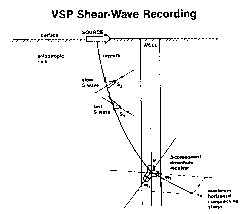
29 DETAILED DESCR$PT$0N OF THE DRAW$NGS
31 Figure 1 is a sectional view of the earth, illustrating the
32 basic model for VSP shear wave reoording.
33
34
Z04521~
01 Figure la is a sectional view of the earth, illustrating the
02 natural coordinate frame foc vertical shear waves.
03
04 Figure 2 is a sectional view of the earth illustrating the
05 basic layer stripping rationale.
06
07 Figure 3 is a plan view of the earth, illustrating the
0~ coordinate frame for recording and processing shear wave
09 data, and the meaning of the 2X2 shear wave matrix.
11 Figure 4 shows the four shear wave components from the
12 1720 ft level of well ll-lOX.
13
14 Figure 5 shows the four shear wave components of Figure 4
after "rotation~.
16
17 Figure 6 shows shear wave data from well 1-9J after
18 "rotationn.
19
Figure 7 i5 a chart that illustrates polarization azimuths
21 of the fast shear waves before layer stripping at the
22 1~9J well.
23
24 Figure 8 is a chart that illustrates the polarization
azimuths of the fast shear wave of the 1-9J well after layer
26 stripping-
28 Figure 9 is a chart that illustrates the polarization
29 azimuths of the fast shear wave of the 1-gJ well as a
function of the initial rotation angle.
31
32 Figure 10 is a chart that illustra~es variatlons in shear
33 wave lags with depth,-at the l-9J well, after stripping off
34 the near surface layer.
-13- ~ 0~2~ S
01 Figure 11 is a chart that shows a summary of polarization
02 angles of the fast shear waves with depth, for two
03 independent layer stripping analyses of the 1-9J well
04 VSP data.
05
06 Figure 12 is a chart that shows shear wave lag with depth,
07 for the layer strippinq sequence indicated by circles in
08 Figure 11.
09
~0 Figure 13 compares off-diagonal components of the 2X2 shear
11 wave data material of the 1-9J well before and after layer
12 stripping.
13
14 Figure 14 i8 a chart that illustrates the polarization
angles of the fast shear wave versus depth for the
16 Railroad Gap VSP data.
17
1~ ~lgure 15 is a chart that illustrates the shear wave lag
19 versus depth for the Railroad Gap VSP data.
21 DETAILED DESCRIPTION OF THE INVENTION
22
23 In accordance with the present invention, a new improved
24 method and means for using layer stripping to determine
fault plane stress build-up has been developed.
26
27 The ob~ective of the data analysis described herein is to
2~ quantify subsurface shear wave (or S-wave) birefringence or,
29 in other words, to find the natural polarization directions
of the two S-waves and the time delays or lags between them,
31 which indicates the direction of fault plane stress.
32 Natural polarization directions are directions along which
33 anisotropic rocks constrain polarizations of S-waves to lie.
34 The purpose of the analysis is to correlate birefringence
-14- 20~5215
01 effects with formation properties such as direction of
02 maximum horizontal stress. Figures 1 and la illustrate the
03 basic model in simplest terms. An arbitrarily oriented
04 horizontal displacement from a surface source propagates in
05 the vertical direction as a fast S--~ave (Sl), and a slow
06 S-wave (52)' with S1 polarized along the direction of
01 maximum horizontal compressive stress.
08
09 The term "polarization" in the context of seismic waves
refers to the shape and spatial orientation of partlcle
11 trajectories. The term is restricted to mean only the
12 spatial orientation of the line along which a particle moves
13 in a linearly polarized wave. Hence "polarization" and
14 "polarization direction", as used here, both i~ply the
spatial orientation of such a line, the latter term
16 emphasizing the restriction to linear rather than more
17 general (e.g. elliptical) motion. A "polarization changen,
la then, does not mean a change, for example, fro~ linear to
19 elliptical motion nor a polarity reversal but only a change
in the spatial orient~tion of the line along which a
21 particle moves.
23 For arbitrary ray directions in anisotropic rocks of low
24 symmetry, a great deal of information is needed to interpret
S-wave time lags and polarizations. .However, if the rocks
26 have vertical twofold symmetry axes, analysis is
27 straightforward if raypaths are vertical, and polarization
28 directions relate in simple ways to symmetries of the rocks.
29 An initial assumption is that the rocks have vertical
symmetry axes and that their symmetry properties do not
31 change with depth. Hence~ in order to have raypaths as
32 close to the symmetry axis as possible, the near offset
33 sources are positioned as close to the wells as possible.
34 Concentric rings of offset VSPs serve primarily as a check
Z0~521S
--15--
01 on our assumption of a vertical symmetry axis. That is,
02 modeling showed that if the verticaI direction is not a
03 symmetry axis, S-wave polarizations at small offsets can
04 vary asymmetrically with azimuth if the rocks are of
05 orthorhombic or lower symmetry, even if there is a set of
06 vectical cracks. On the other hand, if there is a vertical
07 twofold symmetry axis, such S-wave polarizations will have
0~ twofold symmetry.
09
~ determine natural polarization directions of the
11 subsurface rock, several different rotation methods can be
12 applied, as well as hodogram analyses. The most reliable
13 method in our experience is to find the angle at which
14 S-wave energy on off-diagonal components of the 2x2 S-wave
data matrix is a minimum, a method we call the ~rotation"
16 method developed by Alford. All other methods had
17 significant deficiencies. The rotation~ method can be
18 implemented by choosing time windows that include only ~he
19 leading portion of the first arrival S-waves and then
calculating energy ~sums of squares of amplitudes) on the
21 off-diagonal components at rotation angle increments of one
22 degree. Only the leading portions of wavelets need to be
23 included because earlier observations showed that, after
24 rotation to the angle which minimized off-diagonal energy,
the codas of diagonal wavelets differed from one another
26 much more than did their leading edges. Hence, the leading
27 edges are ~uch more interpretable than the codas. The use
28 of time windows provides a considerable signal-to-noise
29 ratio (S/N) advantage over methods which calculate from
individual points, and lends stability and consistency to
31 the answers~ In most cases results are insensitive, within
32 limits, to the length of the time window.
33
34
-16- 20~S215
01 An assumption of the "rotation" method, qenerally not valid,
02 is that S-wave polarizatiolls are orthogonal. However, the
03 assumption is strictly valid along any twofold symmetry axis
04 and is a good approximation close to such an axis. seismic
05 sources can be rotated by the same angle as receivers, which
06 is appropriate for vertical cays along vertical symmetry
07 axes in homogeneous anisotropic media. The differences in
oa arrival times of fast and slow S-waves (the lags) can be
09 computed by crosscorrelating waves on the 2x2 S-wave matrix
diagonals after rotating to the angle that minimized
11 off-d~agonal energy. Lag is observed to increase linearly
12 with depth in a homogeneous, birefringent rock.
13
14 S-wave polarization directions were expected to remain
constant with depth, but data analysis showed convincingly
16 that they did not. Polarizations at Lost Hills field
17 changed relatively little; and if we had considered only
1~ Lost Hills data, we probably would not have deemed it
19 necessary to deal with polarization changes with depth.
Polarization changes in Cymric and Railroad Gap fields to
21 the south, however, were large and unmistakable, and a layer
22 stripping ~ethod developed for data from those areas proved
23 useful also for ~ost HillS data.
24
Layer stripping involves simply subtracting off anisotropy
26 effects in a layer in order to analyze anisotropy effects in
27 the layer immediately below. That is, S-wave splitting is
28 cumulative, so that if anisotropy changes with depth,
29 effects of anisotropy above the change, unless removed, will
persist in the changed region and will confuse an analysis
31 there. ~lthough polarization will change instantly when a
32 wave enters a region with different natural polarization
33 directions, recorded wavelet shapes change slowly and
34 preserve information about ~heir past travels through other
-17- 204~15
01 cegions. Hence, if in polarization analysis one uses a
02 significant fraction of an arriving wavelet, as is done
03 here, rather than just its "first arrival", which no one can
04 accurately pick in real data, one sees the effects of
present as well as past polarizations.
06
07 What specifically hurts the effectiveness of the "rota~ion"
08 method below a polarization change is distortion of signal
09 on the off-diagonal components of the 2x2 S-wave data
matrix. Accuracy of analysis by the "rotation" method
11 depenas, at least in principle, on having signal amplitudes
12 of off-diagonal xY and YX components identical at common
13 times. If they are not identical, the data do not fit the
14 model, and the matrix cannot be diagonalized by a single
rotation of source and receiver coordinate frames. If the
16 signal on XY components differs systematically from that on
17 YX components, there will be systematic errors in calculated
18 a2imuth angles. But changes of polarization with-depth
19 cause just such systematlc differences in signal on XY and
YX componentc; specifically, the signal on one of the two
21 components lags that on the other component by the amount
22 imposed by the upper layer. This point can be understood by
23 visualizing how wavelets in the lower layer of Figure 2
24 project onto natural coordinate axes of the upper layer.
25
26 The inventive layer stripping process assumes certain
27 subsurface properties. For example, S-wave polarizations
2~ must remain practically constant in a given layer.
29 Polarizations hence are assumed to change discontinuously at
layer boundaries, and time lag in a given layer increases
31 monotonically from zero at the upper boundary ~o some finite
32 value at the lower boundary. If polarizations were to
33 change continuously with depth, the meaning of polarization
34 analyses after layer stripping would be unclear. Also, each
z()~215
-18-
01 layer must be thick enough, and its birefringence large
02 enough, to determine the correct polarization direction an~
03 maximum lag foc that layer. In our implementation, wa~e
Q4 propagation is assumed to be close enough to a symmetry
05 direction in every layer so that rotation of sources and
06 receivers by a single angle can do a good job of
07 diagonalizing the 2x2 S-wave data matrix.
08
09 To subtract off effects from above the depth at which
polar~zation change occurs, all the data from below that
11 depth is rotated by the azimuth angle determined down to
12 that depth and then a static shift is appl~ed to remove the
13 time lag between the two S-waves at that depth, as shown in
14 Figure 2. The 51 and S2 waves of the upper layer of
Figure 2 will act as independent sources, generating two
16 sets of S1' and S2' waves at the interface. ~ayer stripping
17 removes the time delay between the two effective sources at
18 the interface, causing the p~imed waves (S1' and S2') to
19 behave as if the interface had been at the surface. The
process simulates pu~ting a source at the depth where the
21 polarization change occurs, such that the simulated source
22 polarizations are oriented along natural polarization
23 directions (assumed orthogonal) of the upper medium. After
24 layer stripping, rotation analysis is repeated as before,
an~d further layer stripping (i.e., ~downward continuation")
26 is applied if, for example, cues in the data indicate
27 further polarization changes.
28
29 These layer stripping principles apply equally to surface
seismic reflection data, but layer stripping will be less
31 effective with reflection data because (1) signal-to-noise
32 ratios are lower than in direct arrival VSP data, and (2)
33 reflection events, which the method must rely on, do not
34 necessarily occur close to where polarization changes occur.
19 20~5215
01 I t may often be necessacy to use information from vSps to
02 layer strip surface seismic data.
03
04 Layer stripping, in contrast to methods involving the
05 calculation of propagator matrices or transfer functions
06 from depth to depth, typically expects the user to judge
07 where to do the stripping on the basis of a preconceived
08 model; that is, he should have criteria in mind for judging
09 from analysis results where polarization directions change.
Despite the more subjective nature of layer stripping vis a
11 vis calculating transfer functions, several possible
12 advantages exist. First, layer stripping keeps the user~s
13 focus on the geophysical objectives rathec than details of
14 calculations. Second, the user is able visually to evaluate
effects of stripping over large blocks of levels; this
16 enables him to identlfy trends and changes in trends without
17 extra effort and thereby to pick layer boundacies
18 perspicaciously. Third, layer stripping improves the
19 quality of data for general interpretation.
21 It is usually necessary in any case to treat data in blocks
22 of several levels at a time, because it is impossible to
23 determine bicefringence effects if the two S waves have not
24 traveled lonq enough in the birefringent medium to have
accumulated a significant difference in arrival times. ~n
26 noisy data, the robustness of birefringence analysis is
27 aided by large lags between S waves.
28
29 Cues that S-wave polarization dicections have changed
manifest themselves as persistent changes with depth, in
31 elther the azimuth angles or the rate of change in time
32 lags. Calculated azimuth angles tend to be insensitive
33 indicators of polariz~tion change below a thick,
34 birefringent layer because properties of the S-wave wavelets
-20- Z0452~5
01 remain much the same below the interface as they were above
02 it, and the angles from rotations consequently tend to
03 remain the same for some distance below the change. In
04 other words, S-wave splitting generates a kind of inertia in
05 azimuth angle determinations. Lags, in contrast, are often
Q6 sensitive indicators of change: If polarization direction
07 changes, the rate of increase in lag usually changes
0~ abruptly, and thus serves as the interpreter~s principal
09 indicator of polarization change.
11 The procedure for layer stripping under normal circumstances
12 may be described in the following manner. The first step is
13 to rotate source and receiver axes, say the x-axes, into
14 alignment with the natural polarization direction o the
fast S-wave in the upper layer. The rotation is applied to
16 all data at and below the level where the polarization
17 changes. We denote this as a rotation from the
18 x-y coordinate frame, whlch is the initial coordinate frame
19 of the sources, into x'-y' frame, the frame of the S-wave
polarization~. The rotation simulates lining up the
21 x source polarization along the direction of the fast s-wave
22 polarization of the upper layer. Ideally, after this
23 rotation, no signal energy would remain on the x~Y~ or Y~X~
24 components of the upper layer; and the signal on the Y'Y'
components of the upper layer should be time-lagged versions
26 of the X'X' components.
27
28 After rotation into the primed coordinate frame comes the
29 ~ey step of applying a static shift to all data generated by
one of the simulated source polarizations, the y', for
31 example; thus the Y'X', Y'Y' and Y'Z' components from all
32 depths at and below the bottom of the upper layer are time
33 shifted by the amount needed to eliminate the lag between
34 X~X~ and Y~Y' wavelets at the bottom of the upper layer.
-21- 20~5215
01 Eliminating this lag is equivalent to positioning simulated
02 x~ and y' source polarizations at the same depth,
03 specifically at the top of the second layer. The initial
04 rotation will not have properly minimized energy on the x'
05 or Y'X' components of the lower layer because the effective
06 x' and y' source polarizations acted as though they were
07 excited at different depths li.e., different times). The
08 "rotations" which follow the stripping, however, should do a
09 good job of minimizing energy on those off-diagonal
components down to the bottom of the second layer. Also,
11 "rotations~ after stripping should cause lags to increase
from a value of zero at the level where chanqe occurs to
13 progressively larger values. Of course, data will not
14 ordinarily be recorded precisely where a change occurs, so
even in principle the lag should not always be strictly zero
16 at the level closest to the interface.
17
18 Further data sets were analyzed from nine-component VSPs
19 recorded at Cymric and Railroad Gap oil fields in
California. A way to tie together conceptually the major
21 S-wave polarization trends of the Cymric and Railroad Gap
22 fields is to view tbem ln terms of stresses on the
23 San Andreas fault. The San Andreas fault runs NW-SE about
24 10 mi SW of the two VSP sites. Zoback et al (1987) cite
much evidence that ~aximum horizontal compressive stress
2C tends So be perpendicular to the fault in central
2~ California, and they propose a model involving convergent
28 plate motion to account for such "fault-normal compression".
29 Ordinarily, stresses associated with a vertical strike-slip
fault plane would cause maximum horizontal compression at an
31 an~le of 30-45 from the fault strike (Zoback et al.,
32 1987).
33
34
-22- 20~2~5
01 If the S-wave polarization azimuths are indicating stress
02 direction, then they indicate maximum horizontal compression
03 nearly orthogonal to the San Andreas at small depths,
04 consistent with the Zoback et al. (198~) model. ~ut at
05 greater depths, in the Antelope shale formation, maximum
06 compression is nearly 45 from the fault strike, consistent
07 with the conventional strike-slip model. As stress builds
08 up before rupture, deeper compressive stresses in close
09 proximity to the fault may become aligned ln directions
conducive to strike-slip motion along the fault. Anticlinal
11 structures parallel to the fault indicate that fault-normal
12 compression historically has extended to greater depths than
13 the Antelope shale, but such compression may vary with time
14 and depth and depend strongly on proximity to rupture along
the fault.
16
17 The above described procedure for analyzing vertical seismic
lB profile shear wave data, or surface seismic reflectors shear
19 wave data may be further described in the following manner.
The data is defined to have at least two linearly
21 independent, nearly orthogonal, and nearly horizontal source
22 axes. Each source axis has at least two corresponding
23 receiver axes.
24
1. An initial analysis of shear wave polarization
26 directions relative to a fixed coordinate frame is
27 performed, and apparent time lags between fast and slow
28 shear waves are determined at several depths.
29
2. Cues in the data are identified that suggest shear wave
31 polarization change.
32
33 3. The natural polarization directions of and the time lag
34 between the fast and slow shear waves in an upper layer
-23- 20~5215
01 are determined, above and adjacent to the shallowest
02 depth where the cues suggest polarization changes.
03 Other depths may be used as well, even if no cues
04 suggest polarization changes.
05
06 4. The source and receiver axes of all the data that are
07 below or at the shallowest depth of indicated
08 polarization changes are then rotated by an azimuth
09 angle determined down to this depth, so that the first
source and receiver axes are aligned with the natural
11 polarization direction of the fast shear wave, and the
12 second receiver axis is at a significantly different
13 azimuth angle, and so that the second source and first
14 corresponding receiver 'axis are aligned with the natural
polarization direction of the slow shear wave in the
16 upper layer, while the second corresponding receiver
17 axis is at a significantly different azimuth angle.
18
19 5 A static shift is then applied to all data components
corresponding to one of the effective sources, either to
21 components correspondlng to the source aligned with the
22 fast shear wave polarization direction or to components
23 corresponding to the source aligned with the slow shear
24 wave polarization directions, to eliminate the time lag
in the upper layer above and ad~acent to the shallowest
26 depth where the cues suggest polarization changes are
27 indicated.
28
29 6. Shear wave polarization azimuth angles are then
determined for the shallowest depth where polarization
31 changes are indicated.
32
33 7. The azimuth angle~ are then compared to the strike of a
34 selected fault which is near enough to be affected by
-24- ~045215
01 compressional or tensional stress which is associated
02 with the azimuth angles.
03
04 8. Time lags between the fast and slow shear waves are
05 determined at least at one depth in the upper layer.
06
07 9. The above steps are then repeated at a later time, to
08 evaluate time varying changes in the shear wave
09 polarization azimuth angles, or in the time lags between
the shear waves. Further shear wave polarization
11 changes can be evaluated by repeating steps 1 through 9.
12
13 The aboYe method may also be used for vertical seismic
14 profile (VSP) data or surface seismic reflection data that
has only a single source axis. Only the receiver axes are
16 rotated in this case.
17
18 If surface seismic refle~tion shear wave data is analyzed,
19 one method lnclude~ an initial analysis of shear wave
polarization directions relative to a fixed coordinate frame
2~ in similarly recorded VSP data from a nearby well, and the
22 subsequent determination of the time lags. Surface seismic
23 reflection shear wave data can also be analyzed without the
24 use of VSP data.
26 EXAMP~E
27
28 1. Lost Hills
29
Data sets to be discussed in detail are from nine-component
31 VSPs recorded in two wells 862 ft apart, the 11-10X and the
32 1-9J wells of the Lost Hills oil field in the southern
33 San Joaquin Yalley of California. 8y nine-component data we
34 mean records from three orthogonal receiver components which
-25- 20~ 5
01 detected waves as if from three separate, orthogonal source
02 polarizations as illustrated on Figure 3. The x-axis shown
03 on Figure 3 is along a source vehicle axis, and receiver
04 axes are computationally rotated after recording to coincide
05 with the source axes. The 2x2 S-wave data matrix consists
06 of four o the nine data components obtained with three
07 orthogonal sources and three orthogonal receivers. For
08 example, the XY data component is from the x source
09 component and the y receiver component. Except for
preliminary processing, only data of the 2x2 S-wave data
11 matrix was treated; that is, data from x and y sources and
12 receivers, or four of the nine components. The coordinate
13 frame for record~ng and processing was a right-handed
14 Cartesian frame with the x-axis along a source vehicle axis.
After determining S-wave polarization directions, we
16 reoriented the frame relative to true north.
17
18 The 11-10X Well
19
For the ll-lOX well, two orthogonally oriented Omnipulse
21 airgun sources were used, and were located 57 and 68 ft from
22 the well and as close to each other as possible. Data were
23 recorded without moving the sources. Source guns were
24 tilted at 45, and each was fired five times left and five
times right for a total of 20 pops per receiver level.
26 Source zero-times were obtained from accelerometers screwed
27 into the baseplates. Locations and azimuths of sources were
2~ determined by surveyors after we completed the VSP.
29
The downhole receiver was a three-component ~3-C) SSC R tool
1 with a Gyrodata gyrocompass for detecmining absolute
32 orientation. With the receiver clamped at the maximum
33 depth, 1720 ft, and sources at vSp positions several series
of source impacts were recorded before, during and after the
-26- Z 0~5~ 15
01 hydraulic fracturing of the 12-10 well to monitor any
02 changes in S-wave polarization that might result from the
03 fracturing. Fracturing did not detectably affect data of
04 the 11-lOX well, although it caused transient changes in
05 data simultaneously monitored in a tlell opposite the
06 12-lO well. After recording at the 1720 ft depth, recording
07 occurred at increments of 80 ft from 1700 ft to 900 ft, with
08 the final level at ~00 ft.
09
1 0
11
12 For the 1-9J well, a single ARIS (ARCo Impulsive Source,
13 provided by Western Geophysical) was used for the near
14 offset portion of the VSP and alternated between two
15 ARIS sources for rings of offset VSPs. For near offset
16 recording, the ARIS was 50 ft from the well. For offset
17 recording, we positioned the sources successively at eight
18 points nominally 45 apart in each of two concentric rings
l9 nominally at 350 and 700 ft from the well. Each source
position was marked with two 14 inch rebar pegs whose
21 locations were subsequently surveyed for accurate source
22 locations and azimuths. For near offset recordinq a special
23 ARIS baseplate pad of riprap and road base gravel was built
24 in order to do all recording without moving the source. For
offset recording no pads were needed because source effort
26 at a given position was small. ARrs made 20 impacts per
27 receiver level or offset position, five in each of four
28 directions--fore, aft, left and right--with the impactor
29 tilted 15 from the vertical. The source vehicle axis
pointed towards the well at every source location. Source
31 zero-times were obtained from pulses from an accelerometer
32 atop the impactor, the pulses transmitted to the recording
33 truck via hard-wire connection.
34
-27- Z0~5215
01 The downhole receiver for the 1-9J well was the LRS-1300 3-C
02 tool with the Gyrodata gyrocompass attached. Receiver
03 components were gimballed so that two were always horizontal
04 and the third vertical. Recording occurred at increments of
05 100 ft from depths of 2100 ft to 100 ft for the near offset
06 VSP but at a fixed 2000 ft for the offset VSPs. After
07 completing the near offset VSP the receiver was lowered to
08 the 2000 ft level. That level was recorded again, without
09 moving the source, before going to the offset VSP locations.
Although the source baseplate was not moved for all near
11 offset recording, it had sunk more than a foot from the
12 beginnlng of near offset recording to the end. The receiver
13 remained clamped at the 2000 ft level without repositioning
l4 for all subsequent offset VSP recording.
16 The well was a nearly vertical cased and cemented hole which
17 had not yet been perforated. Maximum deviation from
1~ vertical was 1.1, and the bottom of the hole was laterally
19 displaced only 10 ft from the top. The fluid level was
lowered to about 300 ft to avoid tube waves, which were
21 undetectable in both wells.
22
23 DATA CONDITIONING
24
Birefringence effects werc analyzed in data which were
26 thought to be as close to being unprocessed as possible, but
27 the following data conditioning steps were deemed necessary.
28 The first step was to calculate and apply zero-time
29 corrections (statics) based on source accelerometer pulses.
The second step was, for each receiver depth or source
31 offset position, and for each receiver component, to sum the
32 five traces of like source polarity and then subtract sums
33 for which impacts were azimuthally opposite in order to
34 simulate a source that applied a purely horizontal impulse.
-28- 2~52~5
01 Such a source pcoduces vertically traveling S-waves with
02 little contamination from vertically traveling P waves. A
03 furthec conditioning step was to rotate the x-axis of the
04 downhole receiver into alignment with the source axis,
05 accomplished with the aid of gyrocompass and surveyor data.
06 Also, data from receivers that were not gimbal mounted were
07 rotated initially to make the receiver z-axis vertical.
08
09 3efore analyzing the data for S-wave polarization
directions, we computationally rotated the receiver data so
11 as to minimize S-wave energy on the vertical components.
12 This rotation, which requires two Euler angles, causes the
13 plane of the two nearly horizontal receiver components to
14 coincide with the plane of S-wave displacements.
16 For near offset VSP data the amount of tilt was small,
17 typically 6-10. Such a tilt puts the receiver plane out
lB of alignment with the source plane, which is horizontal.
19 However, this misalignment i5 unlikely to cause problems
because of the small size of the tilt and because source
21 radiation patterns put S-wave energy nearly equally into all
22 possible S-wave polarization directions for nearly vertical
23 travel. Whether or not the tilt was applied made no
24 difference in azimuth angles and a negligible difference in
lags (0.1 ms maximum) calculated fro~ near offset data. For-
26 the offset data a few of the angles differed by 1.
27
2~ The final data conditioning steps involved amplitude
29 adjustments and bandpass filtering. St is assumed that the
components of body waves in the y direction from the
31 x oriented source must be identical to the components of
32 body waves in the x direction from the y oriented source.
33 That is, to diagonalize the 2x2 S-wave data matrix by a
34 single rotation angle, it is necessary that the XY and
-29- 20~ ~215
01 YX data components be identical, where xY indicates data
02 from the x source on the y receiver. For this case of
03 nearly vertical rays, and under the assumptions of no
04 differential S-wave attenuation and isotropic geophone
05 response, any differences in total wave energy from the
06 x source relative to those from the y source should be
07 attributable to source or near surface properties. Hence,
oa an amplitude adjustment was applied to all data (i.e., data
09 from all three receiver components) of the y source to make
them, in a time window corresponding to the S-wave wavelets,
11 have the same energy as those of the x source. For
12 e~fectiveness of data display the energy of the data in that
13 S-wave time window was also adjusted to be the same at every
14 depth, while taking care not to alter relative amplitudes of
1~ data from a given source component. Finally, to eliminate
16 high frequency noise, a mild high-cut filter was applied.
17
18 RESU~TS
19
Near Offset VSP Data
21
22 Data from the 1720 ft level of well 11-10X are shown in
23 Figure 4 as initially recorded, and in Figure 5 aftet
24 "rotation" to minimize energy on the off-diagonal
components. The similarity of the two S-wave wavelets after
26 rotation is noteworthy, as are the relatively low amplitudes
27 of the off-diagonal components.
28
29 Data from well 1-gJ comprise a much more complete set than
do those of well 11-10X. Figure 6 shows the same data after
31 rotation to minimize energy on the off-diagonal components
32 in the analysis window indicated. Low amplitudes within the
33 analysis window on the off-diagonal components at all depths
3~ suggest the rotation criterion worked well for this data
_30_ 20~5~5
01 set, and that the subsurface S-wave polarizations were
02 relatively uniform.
03
04 Initial rotation analyses gave azimuths for the ll-lOX well
05 data that were nearly constant over their relatively limited
06 depth range. In contrast, analyses of the 1-9J data gave
07 azimuths that showed a substantial and systematic change
08 with depth (Figure 7.) The two data points in Figure 7 at
09 the 2000 ft level were recorded on successive days, one near
the beginning of the expesiment, the other after recording
11 up to the 100 ft level and then lowering the tool again, and
12 hence provide a mea~ure of reproducibility of results. The
13 change in polarization azimuth with depth was counter to
14 expectations from models and led us to suspect that a near
surface layer with a different polarization azimuth was
16 contaminating analysis of deeper data. The strongest
17 indication that S-wave polarizations in the near surface
18 layer were different from those at greater depths is the
19 azimuth of 13 at 100 ft in Figure 7. Subsequent angles
show a systematic increase in azimuth angle, to 31 at
21 200 ft and from there up to about 60 at 2100 ft. The
22 change is not erratic, dS might be expected for random
23 errors, but smooth, indicating a possible systematic error
24 that might be eliminated by stripping off a near surface
layer.
26
27 Initial rotation analyses gave a time lag of 9.6 ms at
28 100 ft and 6.5 ms at 200 ft, below which level the lag
29 increased monotonically down to 800 ft. The 9.6 ms value at
100 ft is assumed to be aberrant, possibly because of the
31 horizontal component of raypath at that small depth.
32 Consequently 6.5 ms was chosen as the amount to strip off
33 initially after rotating source and receiver x-axes to 13,
34 the azimuth calculated at the 100 ft depth.
-31- 20~5215
01 Stripping simplifies the picture considerably. Instead of
02 s-wave polarization aximuths' varying more than 25 for
03 depths below lO0 ft, as they did before stripping, the
04 azimuths now clustec tightly about 60 with standard
05 deviation of 2.8. The first five azimuths, however, show a
06 systematic drop which look as suspicious as the previous
07 systematic rise in azimuth. Hence it is suspected that the
08 initial angle and lag are not optimal. To explore the
09 dependence of the azimuths on initial angle and lag, the
near surface layer is stripped off using several other
ll startlng angles and lags. Results in Figures 8 and 9 show
12 that calculated azimuth angles are insensitive to starting
13 angle but sensitive to starting lag. An angle of 6 and a
14 lag of 5 ms were chosen as the best values. Comparing data
analyses before and after stripping off the near surface
16 layer ~Figure 8) illustrates how a highly birefringent, thin
17 layer can contaminate analysis of data recorded more than a
18 lOoo ft below it.
19
Variations in S-wave lags with depth after stripping off the
21 near surface layer (~igure 10) indicate a significant change
22 in birefringence at about 700 ft. The lags rise uniformly,
23 then level off, then drop before continuing to rise again.
24 If the subsurface were homogeneous, the lags would continue
to increase at a constant rate; while if the rock became
26 isotropic, lags would remain constant. The only way lags
27 can diminish, as they do from 900-1200 ft, is for anisotropy
28 t~ change.
29
Stripping down to 700 ft and then performing the ~rotation"
31 analysis showed that there was no significant change in
32 azimuth and no consistent increase in lags until below
33 900 ft. Azimuth changed between 900 ft and 1200 ft, but
3~ changes in lags there were inconsistent and small, reaching
-32- Z0~2~5
01 a maximum of 2.1 ms. The zone from 900-1200 ft, then,
02 caused too little S-wave splitting to have a significant
03 impact on polarization analysis below 1200 ft. The final
04 layer stripping of the 1-9J well data hence involved
05 stripping off the zone from 900-1200 ft. Note that the
06 azimuth change in this zone was undetectable before layer
07 stripping (Figure 7).
08
09 Results of layer stripping analyses from the surface to TD
are summarized in Figures 11 and 12. On Figure 11, the
11 angles and lags posted alongside the data points indicate
12 values of layer stripping parameters applied at the top of
13 the layer. For example, the near surface layer was stripped
14 off with an initial rotation angle of either 7 or 0,
indicated by the different symbols, and a static of 5 ms.
16 (These angles unlike the others are relative to the source
17 azimuth, which was N6E.) Layer stripping parameters for
18 deeper layers are glven relative to the parameters for the
19 layers immediately above them. The similarity of the two
sets of results shows that a 7 difference in initial
21 rotation angle had little effect on answers at deeper
22 levels. Except for the near surface layer and the zone from
23 700-1200 ft, the subsurface at the 1-9J well (Figure 12)
24 proved to be rather uniformly birefringent.
26 As a check on the validity of layer stripping, it is useful
2~ to monitor VSP traces closely after each stripping to
28 determine whether the results fit layer stripping models.
29 We have found that seismic da~a usually fit better after
layer stripping than before. For example, Figure 13
31 compares off-diagonal components at the deepest levels
32 before and after layer stripping. Traces are from depths
33 below 1200 ft. In the analysis window, signal amplitudes
34 are lower after layer stripping (bottom traces) than before
2~)~5215
; -33-
01 (top traces). This indicates that layer stripping caused a
02 better fit with the seismic model. wave amplitudes in the
03 figure relative to trace spacing are four times those of
04 Figure 6. According to the model, amplitudes of the S-wave
05 direct arrivals should be zero after the "rotations".
06 Although Figure 6 shows that amplitudes of off-diagonal
07 direct arrival S waves are low relative to those of S waves
08 on the diagonals, ~hey are clearly lower after layer
09 stripping than before.
11 Offset VSP Data
12
; 13 Offset data of the 1-9J experiment gave remarkably
14 consistent S-wave polarization azimuths, the mean azimuth
being 55 and the standard deviation 6.3. The consistency
16 results from the high S/N, from the relative simplicity of
17 anlsotropy in that area and from the fact that the near
18 surface layer had little influence on data recorded 2000 ft
19 below it. The lags are much less consistent than the
azimuths and vary systematically along the polarization
21 direction of the fast S-wave. It is likely that the
22 variation in lags derives from shallow raypath segments,
23 because variations of the magnitudes indicated would be
24 unlikely to originate from portions of raypaths in close
proximity, such as those a~ depth, which converge on the
26 receiver.
27
28 Support for this proposed correlation between lag variations
29 and shallow raypath segments comes from comparing lags of
the 11-lOX VSP with those of the near offset 1-9J VSP. The
31 increase in 11-10X lags between 1200-1700 ft resembles that
32 of the 1-9J ~Figure 10). The absolute magnitudes, however,
33 are lower in the 1-9J data by about 8 ms, consistent with
3~ the lag variation observed. eart of the difference in
.
_34_ Z04~215
01 absolute lag ~up to 4 ms) appears to result from a
02 relatively small decrease in 11-10x lag in the anomalous
03 zone from 900-1200 ft, but the rest must occur shallower in
04 the section.
05
06 Cymric and ~ailroad Gap Oilfields
07
oa Further data sets were analyzed from nine-component vSps
09 recorded at Cymric and ~ailroad Gap oil fields in
California.
11
12 At Cymric, major changes in S-wave polarization direction
13 with depth were clearly documented, but the reasons for the
14 changes are not clear. The question iq whether the
polarization changes correspond to changes in horizontal
16 stress direction or whether they simply indicate changes in
17 preexisting cr~cks or other structures. Information on in
18 situ stress directions is sketchy at best for both oil
19 fields, but what data are available at Cy~ric suggest that
the polarization direction of the fast S-wave parallels the
21 direction of maximum horizontal stress below the
22 unconformity at about 975 ft. ~he fast S-wave polarization
23 direction there is about N 10E.
24
Information that corroborates,a nor~herly direction of
26 maximum horizontal stress below the unconformity comes from
27 analysis of tiltmeter data recorded during hydraulic
28 fracturing in the 1116S well located in the adjacent section
29 to the east. Tiltmeter data analysis concluded that
hydraulic fracturinq at a depth of 2300 ft created a nearly
31 vertical fracture striking N 7W+7. This tiltmeter result
32 was obtained after compensating for a point loading force
33 calculated to have been exerted on the surface, and
34
20~5215
-35-
01 subsequently removed, by fluid and propant injected during
02 the fracturing.
03
04 Above the unconformity at Cymric, geologic bedding is
05 relatively flat, consistent with the vSp well~s location
06 neac the crest of a broad anticline. ~elow the
07 unconformity, however, bedding tilts about 35 to the
08 southwest. If anisotropy symmetries tilt similarly, even if
09 there are oriented vertical crac~s or a well-defined
direction of maximum horizontal stress, it is possible that
11 the polarization direction of the fast S-wave may be
12 uncorrelated with the crack or stress direction. Modeling
13 suggests that, if S-wave polarizations of offset vSp data
14 agree with those of zero offset data when anisotropy has low
symmetry, then there i~ likely to be near vertical symmetry
16 axls or "pseudo symmetry axis~; and in relatively simple
17 cases, polarization of the fast S-wave will be oriented
18 along the direction of fracture strike or of maximum
19 horizontal stress. Thus, evidence from analysis of offset
VSP data combines with supplementary information presented
21 above to support interpreting the polarization direction of
22 the fast S-wave in near offset data as the direction of
23 maximum horizontal stress. With "pseudo symmetry axis" we
24 mean that the medium does not have a true vertical symmetry
axis but is so close to having one that is behaves almost as
26 though it did-
27
28 The Cymric near offset VSP data show that the polarization
29 direction of the fast S-wave changes from N 60E in the
uppermost 800 ft to N 10Æ from 800-1550 ft. This change,
31 in view of the foregoing, suggests that the direction of
32 maximum horizontal stress rotated about 50 to the north a
33 short distance above ~he unconformity.
34
- 3 6 - 2045215
01 A correlation of stress direction with S-wave polarization
02 at Railroad Gap is suggested from internal evidence.
03 Ignoring the weakly birefringent third anisotropic layer
04 (Figures 14 and 15) and interpreting broadly, it is noted
05 that the trend in azimuth of the fast S-wave polarization
06 down to about 5300 ft is somewhat like that at Cymric.
07 Figure 14 shows that seven layers were needed to accommodate
08 changes in S-wave polarization. The circles 1 represent
09 azimuth angle data points, and the solid vertical bars 2
represent the extent of each layer. The plusses 3 and
11 dotted vertical bars 4 represent layer stripping that was
12 done with only three layers.
13
14 Figure 15 shows that the vertical S-wave birefringence was
unusually large in layer 1. Also, birefringence is seen to
16 diminish in the deeper layers despite the usual trend of
17 increasing monotonically within a layer.
lB
19 The highly birefringent zone in the Tulare and Pebble
Conglomerate sands at Railroad Gap extends down to 1300 ft
21 (vs 800 ft at Cymric), and the Plio-Miocene unconformity at
22 4250 ft is also much deeper than at Cymric (975 ft). Hence,
23 if S-wave polarization directions are considered in terms of
24 formations instead of absolute depths, the pattern of S-wave
polarization changes at Railroad Gap appears remarkably
26 similar to that at Cymric. Fast S-wave polarization azimuth
27 in the uppermost anisotropy layer at Railroad Gap is N 46E
28 vs N 60E at Cymric. Average azimuth in the next zone of
29 well-defined S-wave birefringence, namely, that from
2900-3700 ft, is N 16E, while that in the deepest zone of
31 well-defined birefringence, namely, from 3900-5300 ft, is
32 N 15W. The difference in fast S-wave azimuth angle between
33 the Tulare sandstone and the Antelope shale is hence about
34 61 at Railroad Gap and 50 at Cymric. Thus, s-wave
-37- Z O ~
01 polarization directions and possibly also stress directions
02 for a given subsurface formation are simply rotated 15-25
03 counterclockwise at Railroad Gap field relative to what they
04 are at Cymric.
05
0~ This similarity in S-wave polarization changes with depth at
0~ Cymric and Railroad Gap supports the likelihood that S-wave
08 polarization directions are determined by stress directions.
09 That is, if stress determines S-wave polarizations in one o
the two areas, for example, Cymric, then the similarity in
11 behavior suggests that it does so for both.
12
13 The reasons for the ohanges of fast S-wave polarization
14 direction with depth at Cymric and Railroad Gap are unknown,
but at Cymric the proximity to the Plio-Miocene
16 unconformity, a major angular unconformi~y, is suggestive.
17 Hickman et al. (198a) observed analogous changes in stress
18 direction over a 500-700 ft interval in the Hi Vista well
19 located in a similar posltion relative to the San Andreas
fault. They point out that rapid variations of stress
21 magnitude and direction with depth have been observed
22 elsewhere but have seldom been adequately explained. They
23 suggest that a major stratigraphic discontinuity or slip on
24 a fault might abruptly change stress magnitude or
orientation.
26
27 LAYER STRIPPING RESU~TS
28
29 S-wave polarization azimuths are consistent with depth for a
given anisotropic layer at Lost Hills; that is, in the near
31 offset VSP they are conslstent from 200-900 ft and from
32 1200-2100 ft. Consistency is noteworthy because each
33 calculated azimuth is the result of an independent set of
34 measurements. The lesser consistency in the deeper zone is
-38- ~ O'~
Ol expected, because layer stripping removes the "inertia~ that
02 builds up in polarization determinations as the lag between
03 the S-wave wavelets increases. The high o~erall consistency
04 in polarization azimuth results from consis~ency in
05 subsurface properties, from high signal/noise (S/N) in vsP
06 direct arrivals and from the fact that waves along vertical
07 raypaths satisfy the model assumptions employed in data
08 analysis. The consistency in azimuth justifies the layer
stripping model, which implicitly assumes that S-wave
polarizations remain constant over appreciable depth ranges,
11 and s~ggests ~hat we would have obtained no better results
12 by calculating transfer functions.
13
14 Layer stripping wa effective and important for eliminating
effects of a thin, near surf~ce anisotropic layer which had
16 natural S-wave polarizations different from those of deeper
17 materials. Layer strlpping was less important for dealing
18 with a change in anisotropy from 700-1200 ft because of the
19 s~all change in lag there. It is evident from data analysis
(Figures 7 and 8) that the near surface layer adversely
21 affected polarization analysis down at least to 1500 ft, and
22 to a serious dsgree down to about 600 ft; but the effect is
23 small at the deepest levels. ~irefringence of deeper
24 formations will overcome conta~ination from a near surface
layer when the lag from the near surface layer is small
26 compared with a wavelengt~ and when the lag between 51' and
27 S2' is much larger than the lag from the near surface layer.
2B Figure 2 makes i~ apparent that, if the lag from the near
29 surface layer were to approach a significant fraction of a
wavelength, layer stripping would be necessary in order to
31 analyze data by "rotations~. However, when lags are that
32 large, other analysis techniques may work well.
33
34
-39-
~1 While a preferred embodiment of the invention has been
02 described and illustrated, it should be apparent that many
03 modifications can be made theceto without departing from the
04 spirit or scope of the invention. Accordingly, the
05 invention ls not limited by the foregoing description, but
06 is only limited by the scope of the claims appended hereto.
07
oa
os
11 -
12
13
14
16
17
18
19
21
22
23
24
2~
21
28
29
31
32
33
34