Note : Les descriptions sont présentées dans la langue officielle dans laquelle elles ont été soumises.
- 1_218067
Method for ~itoring an area
The invention relates to a method for monltoring
an area, in accordance with the preamble o claim 1.
It ha~ been known for a long time for potentials
S to be determined on the surface of an area to be moni-
tored, which potentials give information on the strength
and course of subterranean disturbances, especially
dynamic changes. For example, it is known, for this
purpose, for high currents to be passed into the bedrock
and for the potentials in the region around the current
introduction point to be determined successively. It is
furthermore known for self potentials to be determined
with respect to a base probe.
The determination of the potentials can yield
good results particularly in the case of dynamic bedrock
changes, for example in the case of artificial fracture
production. Breaking the rock by means of hydraulic
pressure results in seismic or seismic-acoustic events
and electrical conductivity changes. In particular,
ao filtration potentials and potentials on the basis of a
geochemical change in the bore flushing are produced as
a result of in;ecting liquid or steam into the rock
formation at high prossure and in a short time. In
con~unction with this, an electrolyte is compressed by
the rock c~pillaries, which act like a diaphragm. The
electrochemical double layer which originally exists in
~olid/fluid form on the boundary surface is in con-
seguence decomposed into a stationary adhesive part and
a non-stationary diffusive part. This results in a poten-
tial differonce as a conseguence of the electricalcharges between the ends of the capillaries.
However, the potentials to be measured at the
surface are very small.
Naturally and artificially produced telluric
current~ occur, in particular, as di~turbance signals,
which currents are caused, for example, by industrial or
railway systems and whose amplitudes are above the order
of magnitude of the potential differences to be measured.
The known methods can thus be used only to a limited
21~8Q~7
2 _
extent for detecting condition changes in tho bedrock.
EP 477,167 di~closes a method for nitoring an
area, in the case of which method the potential ~8
measured by means of probes at a plurality of measurement
points in the area and is converted into electrical
signal~, the 3ignals being interrogated and processod at
specific time intervals by a central computer unit. The
measurement points are in this case arranged at predeter-
mined intervals along a closed line which encloses the
area. In addition, a number of measurement points are
provided underneath the area. This known method can be
used, in particular, for detecting waste dumps in terms
of potential. This method is based on measuring long-term
changes in the condition of a dump. It relates to
moasuring potential differences from ono measurement to
the next measurement without being able to make any
statemont on the absolute condition of the area.
DE-PS 962,105 discloses a method for locating and
prospecting for usable deposits in the ground with the
aid of self-potential measurements, a current conductor
having a hlgh controllable resistance being connected in
parallel to the input of the potential test set after
moasuring the solf potential of the ground to be invest-
igatod. That resistance value is determined at which the
potential of tho ground, when the resistance is switched
on, falls to a fraction of the potential value measured
without current consumption.
DE 392,189 also discloees a method for deter-
mining the earth resistance in conjunction with potential
moasuromonts.
DE 3,529,466 discloses a method for determining
limits of subterranean dsposits which are filled with
hydrocarbons and in the case of which measurement probes
are arranged in a grid and self-potential curves are
dotected.
The invention is based on the object of providing
a method for nitoring an area with the aid of self-
potential meaourement, in the case of which method the
influence of telluric currents is largely precluded and
2 1 ~ fi 7
-- 3
good accuracy and reliability of the determined results
can be achieved.
This object is achieved by means of the inv~nt~on
specified in claim 1. Advantageous developments of tho
invention are specified in subclaims.
~ he method according to the invention is distln-
guished in particular by the fact that, in addition to
determining the potentials at the individual measurement
probes, the earth resistance between the same measurement
probe and the base probe is in each case determined
immediately before and after a measurement. Thus, not
~ust the value of the self potential but, in particular,
the value of the currents flowing, which value results in
the case of the self-potential measurement taking into
account the earth resistance, are used for evaluation.
The measuremont probes are preferably arranged in
mutually parallel groups along measurement lines. In one
example which is describQd, each group contains 16
mQasurement probes and there are a total of 16 groups,
resultlng in a total number of 256 measurement probes.
Each group of measuromont probes is, in particu-
lar, allocated a momory unit in which the simultaneously
dotected potent~al values of the measurement probes of
tho associated group are buffer-stored. In this case, all
measurement probes of the entire grid are interrogated
simultaneously 80 that thero aro 16 measurements in each
memory unit at the samo moment in time, which measure-
mQnts are buffer-stored. These buffer-stored values are
then transmitted cyclically to a contral processor unit.
This allows the condition of the potential of all the
measurement probes laid out to be determined at a single
point in time. The measurement data can then be trans-
mitted to the central processor unit cyclically, between
two successive measurements.
In particular, the earth resistance is measured
before and after each measurement of the self potentials.
This results in a tight time allocation of the potential
measurement to the earth-resistance measurement. Although
the earth resistance is not measured at the same time as
2108n~7
-
-- 4
the self-potential measuremQnt, the time changes in tho
earth resistance are, however, as a rule emaller than the
changes in the potential values within the time ~nterval
considered.
The earth resistance is likewise measured with
the aid of measurement probes and the results are trans-
mitted to the memory units and buffer-stored in the same
way as the potential values. They can then be transmitted
cyclically to the central processor tmit. In order to
achieve a high measurement cycle time, it can also be
provided for the earth resistance mQasurement not to be
aarried out until after a relatively large number of
potential measurements.
The determined self potentials of the measurement
probes are preferably transmitted in analog form to the
associated memory units of a group. In consequence,
analog/dig~tal converters on each individual probe can be
avoidod. Furthermore, central filters, for example low-
pass filters, can be used in a memory unit. The filtering
can also be carried out in the digital area, subseguent
to the buffer-storage. The measurements of the earth-
resistance measuremont are likowise transmitted in analog
form to the associated memory unit and are transmitted
cyclically to the central processor unit after analog/
digital con~ersion. The cyclic transmission of the self-
potential values and earth-resistance values from the
memory units to the central processor unit preferably
take~ place in digital form, using tlme-division multi-
plexing. The interrogation tlmo for one group of
moa~ur ont probes is preferably 0.5 ms. The cyclic
transmission of data from the memory units to the central
processor unit takes place in a time of less than 10 8,
for example in 2 8.
In order to measure the earth resistance, a
roference voltage is preferably applied between the base
probe and the respective measurement probes. At the same
time, the voltage dropped on a measurement resistor is
determined and the earth resistance is calculated from
this.
21~8~7
-- 5
The measurement probes are, in particular, probes
which cannot be polarized.
For evaluation, the determined self potentials
are assessed using the determined earth resistance and
are presented in the form of iso-lines on a map showing
the area. In this case, it can in particular be provided
that difference potential~ between ad~acent measurement
probes be used rather than the absolute potential values
at the individual measurement probes, in order to pre-
clude telluric currents.
The invention allows highly accurate detection ofthe self-potential distribution over an area at points in
time which can be determined precisely in time, with
disturbance signals and earth resistance changes largely
being procluded.
The invention is explained in more detail in the
following text, with reference to an exemplary embodiment
and figures where
Fig. 1 shows a sketch of a measurement
arrangement,
Fig. 2 shows a representation of the measurement
eguipment used,
Fig. 3 shows a sectional view of a measurement
probe,
Fig. 4 shows an outline representation of a
memory unit,
Fig. S shows an outline representation of the
earth resistance measurement,
Fig. 6 A - H show results of a measurement of a
fracturing process.
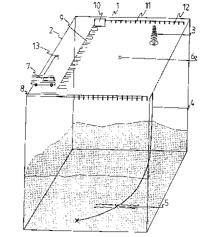
Fig. 1 shows an area having edges 1, 2, with a
measurement arrang ent fitted above ground. A drilling
string 4 leads from a derrick 3 into an oil-carrying
sandstone in which it is intended to break up the sand-
stone in a fracture region 5. The vertical projection of
the fracture point on the surface i8 ~hown by the number
6. A central computer controller, with a central pro-
cessor unit and evaluation device~, is accommodated in a
measurement vehicle 7.
....
, .. ....... . .
_ 6 2t 0 ~ 067
Sixteen memory units are arranged at the same
spacing along a telemetry cable 9, the fir~t m~mory unit
being designated by the number 8 and the last memory unit
by the number 10. A cable 11, which leads to the indl-
vidual meaRurement probes 12, is connected to the memoryunit 10 and al~o to every other memory unit, a total of
16 probes being arranged along the cable 11. The complete
measurement grid thus contains 256 probes. A base probe
13, which is likewise connected to the measurement
vehicle, is arranged outside the measurement grid.
A current is fed in between the base probe and
the individual measurement probes for earth-resistance
measurement, while the potential measurement is carried
out in a voltage-frea manner between the base probe and
the measurement probes.
Fig. 2 shows a computer system which can be used.
A cable 11 is shown to which 16 measurement probes 12 ars
connected. The cable ll leads to a memory unit 8. The
latter contains, in particular, a 16-channel preamplifier
ao with an analog filter 14 followed by a 12-bit analog/
digital converter, a microprocessor 16 and a power supply
unit 17. The signal filtering is preferably carried out
in the analog domain, separately for each individual
moasuremont probo. However, it is also possible to carry
out the filtering at least partially on the digital
signal.
The data determined from the 16 measurement
probos are buffer-stored in the memory unit 8 and are
avallable for interrogation by the central computer.
A control unit 18 for earth-resistance measure-
mont is provided in the central computerO Furthermore,
the data interrogated from the memory units 8 are trans-
mitted via an RS232/485 converter 19 to the control
computer 20 and can be stored on a hard disk 21. A floppy
disk 22 and a power supply unit 23 are also provided. The
results of the measurements can be printed out on a
printer 24. The computer is operated via a keyboard 25.
A monitor 26 is also provided, for displaying measurement
results and for controlling the computer.
21~fi7
Flg. 3 shows a measurement probe which can be
used. A hollow ceramic housing 27 is provided whlch is
partially filled with copper-sulfate solut~on 28. Pr~-
cipitated copper sulfate 32 is present at the lowsr end
of the housing. A copper rod 29, which is held at the
upper end of the ceramic housing by a rubber plug 30, is
inserted into the copper-sulfate solution 28. The
measurement probe is connected to the cable 11 v~a a
connecting cable 31.
Fig. 4 shows an outline view of the memory unit.
The individual measurement probes are connected to an
analog/digital converter 40 via dedicated preamplif~ers
39 and filters 41. The outputs of all the analog/digital
converters of a group lead to a sample and hold memory
unit 42 which buffer-stores tho data. From here, said
data are passed cyclically to the central computer 44,
via a multiplex interrogation 43, and are shown on the
display unit 45.
Fig. 5 shows the principle of earth-resistance
measursment. A DC voltage source 33 is provided whose
circuit passes via the bass electrodo 13, thQ earth
rssistance 35, a measurement probe 36, a switch 37 and a
measuremont rssistor 38. The switch 37 is clossd during
the earth-resistance measurement. The voltage dropped on
ths msasuremont rssistor 38 is amplified via the ampli-
fier 39 and is passed to the analog/dig~tal convsrter 40,
in the same way as the potential-measurement data from
the probe.
While measuring the potentials on the measurement
probes, the switch 34 is closed and the switch 46 is
open. The switch 37 is open while measuring the poten-
tials. The potential difference between the base elec-
trode 13 and the measurement probe 36 is determined in
the same way from the potential difference between the
amplifier connection of the amplifier 39 and ground.
The potentials determined can be evaluated
directly, although it is preferred to u~e potential
differences b~tween ad~acent probss for the evaluation in
order to eliminate telluric currents in the bedrock from
21 0~ Ofi7
- 8
the measurement. It i8 in this case assumed that the
telluric currents essentially act in the same way at the
same time on all measurement probes.
Fig. 6A shows the representatlon of an area o
size 200 x 200 m before a fracturing process is carriod
out. There is a disturbed probe at the point 47. The
representation does not show any prefsrred distribution
of the determined potential values.
Fig. 6B shows the condition of the potential
distribution approximately 15 minutes after initiation of
the fracturing process.
Fig. 6C shows the condition after 20 minutes, it
already being possible to see an alignment of changed
potential values from top left to bottom right.
Fig. 6D shows a clear orientation of the poten-
tlal values after approximately 25 minutes, which orion-
tatlon lasts to a time of 85 minutes (Fig. 6E, 6F). After
90 minutes (Fig. 6G), the presentation changes back
towards the original condition (Fig. 6H).
The invention can be used not only for obtaining
information on fracture directions and extends, but i8
furthermore suitable for o~taining information on ore
dQposits, for investigating dams and dikes for soaling,
for establishing the contours of contaminated ground
water in the outlot aroa from and into dumps, for ob-
taining information on contamination focuses in the
ground, for determining gas/salt-water contact in subter-
ranoan gas stores, and other underground events which
influonco the potential values at tho surface.
A large number of results can be extracted from
tho data determined, since all the data are stored in
digital form. In particular, statistical parameters such
a~ the mean value, scatter, standard deviation (for each
probe), contours of potential anomalies etc. can be
determined. Furthermore, individual probe profiles can be
solectod from the ovorall measurement configuration.
Various intorpolation mothods allow a grid-network to be
produced. The representation can be produced in the form
of iso-lino maps or 3D representations. The
2~ ~067
g
representation can bs carried out both in real tlme and
subsequently.
The results can be normalized to speciflc probe~,
specific points in time or specific potential value~. In
principle, there are no limits on the evaluation po~-
sibilities.
Commercially available units, for example com-
puters based on 68000 processors, can be used as the
computer.