Note : Les descriptions sont présentées dans la langue officielle dans laquelle elles ont été soumises.
CA 02255127 1998-12-17
METHOD FOR DETERMINING THE ORBITAL POSITIONS
OF SATELLITES IN LEO NETWORKS
FIELD OF THE INVENTION
The invention relates to a method for determining the orbital positions of
satellites in
LEO networks with ring constellations. The invented method is usable
everywhere in
orbits that have the geometry of LEO satellite networks. The word "LEO",
singular or
plural, is employed interchangeably herein to refer to any orbital altitude,
e.g.also in
"MEO" and not to Low Earth Orbits alone.
BACKGROUND OF THE INVENTION
Inter-satellite links are used in connection with communications satellite
systems,
which are moving in low earth orbits (LEO) and relate to so-called global
communications networks, in order to connect the individual satellites of the
system in
the manner of a "network in the sky". Many satellite systems have already been
planned or are even under construction. Satellites) which permit real time
transmission
of data, sound and video and are known as "big LEOs", are particularly
important for the
CA 02255127 1998-12-17
-2-
present invention. Examples of this are the so-called IRIDIUM and CELESTRI
systems,
originally introduced by Motorola, and the TELEDISC system of Microsoft and
McCaw
Corp. It is expected that these systems will be functional around the year
2005.
The use of inter-satellite links (ISL), besides the customary earth links
(downlinks
and uplinks, i.e. from the satellite to the ground or vice versa),
distinguishes the above
mentioned LEO systems from others) such as GLOBALSTAR (by Globalstar
Telecomms. Ltd.).
The main purpose of the global real time satellite communications networks
lies in
assuring a variable time-dependent transmission capacity to any location in
the entire
world when needed. Such a dynamic communications network requires real time
management. In addition, a universal ana easy access to me neiworK is aemanaea
when a wireless access is offered such as is the case, for example, with
IRIDIUM. The
determination of the exact orbital positions of all satellites is performed by
the ground
station.
Customarily the maintenance and control of an orbit of a satellite is
controlled from
the ground. The required orbital adjustment is calculated by the ground
station, and a
number of commands is generated and uplinked to the satellite, which are then
downlinked again for checking. Finally, the ground station transmits a command
for
starting the control commands and the satellite performs them by using its own
cycle
generated on board. Such a sequence protects the satellite against
transmission errors,
since often it is out of sight of the ground station.
Recently autonomous navigation systems have aided in making an autonomous
maintenance of the orbit possible, efficient and dependable. These systems can
be
aided by GPS, or can operate completely independently (MANS by Microcosm). In
connection with LEO communications networks, the economical aspect of
maintaining
the orbit and the constellation are of decisive importance, since a large
number of
satellites - up to several hundred - must be controlled simultaneously.
The so-called checked autonomy, wherein the orbital maneuvers are initially
calculated on board of each satellite, but are only executed after a check by
the ground
station, is a mechanism for reducing the risks and for utilizing the autonomy
in
maintaining the orbit.
The greater portion of the LEO satellite networks mentioned above consists of
several orbital planes at the same height all around the earth. Generally all
orbits of an
CA 02255127 1998-12-17
-3-
LEO network have the same inclination in respect to the equator. The same
number of
satellites is distributed at the same distances from each other in each
orbital plane.
Such constellations are called "Walker" orbits. The total number of
satellites) followed
by the number of orbital planes and the inclination of the orbital plane, are
characteristics, which permit a differentiation between all existing LEO
network
concepts.
There are sub-groups within a satellite network, which each have a
predetermined
number - between four and eight - satellites connected with each other for the
mentioned communications purposes. Viewed from a satellite in the center of
such a
sub- group, two types of inter-satellite links can be distinguished: "inter-
satellite links
within the plane", i.e. links with satellites, which are ahead or behind, but
in the same
plane) and "inter-satellite links between the planes", i.e. links with
satellites located in an
adjacent plane or in a plane adjacent to the latter. An additional
characteristic of each
satellite network is expressed by the so-called "phase between the planes",
the angular
displacement, which constantly results during the course, between a central
satellite of a
sub-group and an adjacent satellite in the directly adjacent orbital plane.
An important problem, which results normally in each real time LEO satellite
network operating with a fixed "phase between the planes", is to assure that
the satellite
of the same sub-group always remain in the same relation toward each other.
This
requirement is the result of the need to overlap the covered ground zones.
The employment of navigation methods performed or supported from the ground
for
monitoring the large number of satellites in LEO networks represents a
relevant cost
factor in maintaining the orbits during the working phase of an established
satellite
network.
OBJECT OF THE INVENTION
It is therefore the object of the present invention to create a method of the
type
mentioned at the outset, which is less expensive in maintaining the orbit
during the
working phase of an established satellite network.
This object is attained by a method with the features recited in the
characterizing
portion of claim 1.
Advantageous embodiments of this method are recited in the dependent claims.
CA 02255127 1998-12-17 .
-4-
The invention will be explained in more detail in what follows by means of the
drawings.
BRIEF DESCRIPTION OF THE DRAWINGS
Fig. 1 is a schematic representation of the linkage of individual formations
with
each other in accordance with the invention,
Fig. 2 is a schematic representation of a satellite formation in accordance
with the
invention, having a master satellite, which communicates with a ground
station,
Fig. 3 is a schematic representation by means of the example of the CELESTRI
system of individual formations in accordance with the invention, and
Fig. 4 is a schematic representation by means of the example of the CELESTRI
system of a formation in accordance with the invention with a continuous ISL
connection
during the crossing of the orbital planes.
DETAILED DESCRIPTION
Six orbits are represented in Fig. 1 by respectively one orbital line P1 to
P6.
Several satellites can move one after the other in each orbital plane at
approximately
even spacings. Only some of these many possible satellites are represented in
Fig. 1,
namely satellites 1 and 2 in orbit P1, satellites 3) 4 and 5 in orbit P2,
satellites 6, 7 and 8
in orbit P3, satellites 9 and 10 in orbit P4, satellites 11, 12 and 13 in
orbit P5 and
satellites 14 and 15 in orbit P6.
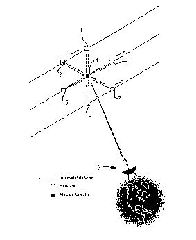
The satellites 1 to 5, 7 and 8 are individually represented in Fig. 2. The
satellite 4)
which is in a central position, is selected as the master satellite in the
sense of the
invention, so that it is connected, respectively bidirectionally, via earth
links with a
ground station 16, and via IS links with the other satellites.
Therefore, satellites 1 and 2 form a first ring constellation, satellites 3, 4
and 5 a
second ring constellation, and satellites 7 and 8 a third ring constellation.
Generally, a
satellite network in accordance with the invention is formed from at least two
ring
constellations, which all orbit at the same orbital altitude, wherein a ring
constellation
CA 02255127 1998-12-17
-5-
consists of at least two satellites which circle in the same, in most cases
circular, orbit at
a defined fixed angular offset in respect to each other.
The satellites 3, 4 and 5 of the second ring constellation form a sort of a
communications ring in their orbit, because they are connected with each other
via IS
links. Inter alia, the present invention is based on the knowledge that
miniaturized
optical terminals, in combination with a specific terminal accommodation on
board the
satellite (Swiss Patent Application 1153/97), make possible uninterrupted
inter-satellite
communications not only between satellites in the same orbit, but also between
a
master satellite and the individual satellites of other adjacent ring
constellations. In the
sense of the present invention, the linkage between individual satellites of a
ring
constellation and individual satellites of other adjacent ring constellations
is considered
to be a "formation". This brings the advantage that, in addition to the actual
communications purposes, the realization of a very inexpensive, permanent,
constantly
updated information regarding the respective course positions of all
satellites of the
respective formation becomes possible, wherein this information can also be
used to
maintain an exact "phase between the planes" of all satellites in a formation.
When using continuous inter-satellite communications as described above, inter-
satellite links can be supported by computations performed in the master
satellite in
order to achieve a considerable reduction of the outlay required on the ground
in
connection with the accurate calculation of the exact orbital position of each
individual
satellite of the constellation.
To achieve this goal, first the exact orbital position of the preferably
central master
satellite in a formation is determined, and this autonomously on board the
satellite by
means of customary measurements supported from the ground, or respectively by
means of GPS, MANS. Then the exact position of all other satellites in the
same
formation is determined from range and pointing data, which must be provided
by each
IS link terminal (Fig. 2). These pointing data are well known after the
establishment of
the inter-satellite link and are continuously updated.
Since at least one satellite of a network is always in contact with the ground
station,
any required information regarding each satellite of this network is always
available in
that a suitable route is formed via the various inter-satellite links, and
this even when the
satellite of interest is not within the sight range from the ground station.
CA 02255127 1998-12-17
-6-
Fig. 1 shows that a satellite network can be considered to consist of several
formations, which together constitute the entire network. Although all
satellites can be
designed in the same manner, in Fig. 1 the satellites of the first formation
are
represented by small square ideograms, the satellites of the second formation
in a
similar manner by triangles, and the satellites of the third formation by
circles.
Thus, it can be seen from the drawings that the satellites 3, 4, 7 and 8
participate
both in the first and the second formation, and that the satellites 9 and 10
are members
of the second and third formation. It is practical to select the satellites 4,
7 and 12 as
master satellites in this example. The determination of the orbital position
of the master
satellites of a formation is provided by the use of traditional methods from a
ground
station, or respectively by the employment of GPS or MANS.
The exact orbital positions of all satellites of a formation are determined in
that use
is made of the information from the respective inter-satellite link between
the central
master satellite of the formation and a satellite of interest from this
formation.
Customarily this inter-satellite information consists of range information,
range-rate
information and angle information in the pointing direction (azimuth and
elevation). If
the actual angle between the inter-satellite terminal of the master satellite
and the
satellite of interest is known) it is possible to determine from this the
pointing vector from
the master satellite to the satellite of interest.
In particular, the inter-satellite range information is extremely useful in
connection
with LEO networks with fixed inter- satellite phases, for example IRIDIUM or
CELESTRI.
By monitoring the range information of an inter-satellite link it is possible
to predict
whether the satellites of a formation are in fixed states in respect to each
other, or
whether relative movements take place. Therefore, by monitoring of the inter-
satellite
range information it is possible to compensate for mutual relative movements
between
the satellites. Such a longtime drift is mainly caused by the effects of the
sun, the moon
and possibly the atmosphere. Since such a prediction is very sensitive, it is
possible to
perform small corrective maneuvers by means of the drive jets of the
satellites before
positional errors become cumulative.
By means of the invention it was learned that in theory, when using p
formations in
a network consisting of k satellites, the outlay for measurements which must
be
performed in the ground station to determine the exact orbital positions of
all k satellites
can be reduced by the factor k/p. It is not possible in actuality to attain
this value, since
each network has an edge, which constitutes a border of the network and
therefore also
. CA 02255127 1998-12-17
-7-
a geometric interruption thereof. Therefore some additional inter- satellite
links are
necessary for determining the positions of the satellites of a constellation
which are
located in the vicinity of the edge.
The additional information regarding the pointing (alignment) data of all
inter-
satellite terminals of a master of a formation - including values regarding
distances,
angles and their chronological derivations of d/dt and d2/dt2 - permit an
improvement of
the accuracy of one and the same position measurement by overlaying all
pointing data.
As a rule, formations consist of five to nine satellites. Based on an
improvement by the
factor n with n pointing data sets involved in the position determination, an
improvement
of the accuracy by a factor of 2.2 up to a factor of 3 results.
The presence of on-board computers in all satellite types of LEO networks
makes it
possible to let the satellite perform a running update and storage of its
position and
pointing data sets autonomously, preferably during times of reduced activity,
or
respectively reduced burdening by other satellite sub-systems.
In case a satellite in a formation ceases to operate, it is nevertheless
possible to
determine the position of all other satellites. Even if the central satellite
of a formation
fails, a new master can be chosen from one of the adjacent satellites.
An inherent redundancy of satellite networks results because each satellite
normally
is connected by more than one inter-satellite link with other adjacent
satellites.
Therefore every inter-satellite link can determine the exact position of a
satellite via an
interpositioned master. From the similarity of the structure of all satellites
of a network
arises the possibility of selecting, in response to the requirements, any
satellite as the
master of a formation. Therefore, an exact position determination of all
satellites of a
formation is made possible in an excellent manner by means of the ring-
overlapping
continuous connection of all satellites of a formation.
Fig. 3 shows some formations of the CELESTRI LEO network. From this it is
possible to see that the geometric satellite network is built up of ring
constellations, and
that a communications network consists of ring-overlapping formations.
By means of a CELESTRI example) Fig. 4 shows that a continuous ISL connection
within a formation is also possible even when orbital planes are crossed.
CA 02255127 1998-12-17
.$.
The long-term monitoring of all pointing data of the inter-satellite links of
a master
can in addition be used for transmitting control signals for the orbital
correction to the
satellite of the respective inter-satellite link when a defined tolerance
threshold has been
exceeded.