Note : Les descriptions sont présentées dans la langue officielle dans laquelle elles ont été soumises.
CA 02268939 1999-04-16
WO 98/18022 PCT/GB97/02924
1
1 SEISMIC ACQUISITION SYSTEM USING WIRELESS TELEMETRY
2
3 This invention relates to seismic acquisition using
4 geophones.
6 It is well known to conduct a geophysical survey of a
7 land area by using an array of geophones in conjunction
8 with either a succession of explosions or a continuous
9 vibration applied to the ground by a vibratory
apparatus.
11
12 Although the results obtained are valuable,
13 conventional techniques are logistically slow, labour
14 intensive, and costly. It is necessary to deploy a
large number of geophones on a grid which has been
15 previously surveyed. Each geophone string is
17 individually wired to a central control unit. As the
18 survey progresses, geophones in the rear must be
19 disconnected, repositioned at the front, and
reconnected. This procedure is extremely laborious,
21 and the complexity of the connections gives a high
22 probability of error. The scale of the problem will be
23 understood when it is realised that a typical 3D
24 seismic array involves up to 750 km of cabling.
CA 02268939 2004-10-14
2
An object of the present invention is to provide a means to
simplify these procedures, and thus to reduce the time and
cost of the survey by a significant factor.
Accordingly, the invention from one aspect provides a seismic
acquisition system comprising: a multiplicity of geophone
units arranged in an array across a survey terrain, each
geophone unit comprising means for deriving digital data
representative of seismic movement of the earth's surface at
the geophone location, each of the geophone units further
comprising wireless telemetry means adapted to receive
command signals from a central control and to transmit the
digital data on demand; the survey terrain being divided into
a number of cells each of which contains a plurality of
geophone units and a cell access node, the geophone units in
each cell communicating with the respective cell access node
by wireless telemetry using a single frequency per cell, and
the cell access nodes communicating with the central control.
In a preferred form of the invention, the terrain is divided
into a number of cells each of which contains a number of
geophone units and a cell access node. The geophone units in
a given cell communicate with the respective cell access node
using wireless telemetry at a given frequency, with different
frequencies used in adjacent cells.
The cell access nodes may communicate with the central
control by radio, or by cable or fibre optic link.
The communication within each cell is preferably high
frequency (most preferably 2.4 GHz band) low power. This
CA 02268939 2004-10-14
3
permits a limited number of frequencies to be reused across
the terrain.
The means for deriving said digital data may comprise an
analog geophone measuring velocity, coupled to an analog-to-
digital converter.
Each of the geophone units is preferably provided with a
memory for short term storage of the data, and for permanent
storage of a unique code identifying that geophone unit.
Preferably, each of the geophone units has a preamplifier and
preamplifier control means remotely operable from the central
control. The preamplifier control means may be operable to
control the gain and/or an operating time window of the
preamplifier as a function of the distance of that geophone
unit from the location of the seismic signal source being
monitored, and/or as a function of time.
Each of the geophone units may additionally have its unique
code physically embodied internally or externally, or
electronically tagged on a microprocessor forming part of the
geophone unit, or as an external display for example in the
form of a machine readable bar code, all of which can be read
by wireless method using existing hardware.
The wireless telemetry means is preferably digital, and may
comprise a dedicated wireless system, or may be provided by a
cellular wireless system.
From another aspect, the invention provides a method of
conducting a seismic survey, in which a multiplicity of
geophone units are positioned in an array across a terrain of
interest; a series of seismic events is generated to produce
seismic signals collected by the geophone units; the data
CA 02268939 2004-10-14
3a
for each of the geophone units is stored in digital form at
the geophone unit; and the data is transferred, at a later
time, to a central location by radio, by cable, or by fibre
optic link; the terrain is divided into cells each of which
contains a plurality of geophone units and a cell access
node; and each geophone unit transmits the data to its
respective cell access node in digital form by wireless
telemetry at a frequency which is common to all geophone
a .. , " ,
CA 02268939 1999-04-16
WO 98/18022 PCT/GB97/02924
4
1 An embodiment of the present invention will now be
2 described, by way of example only, with reference to
3 the drawings, in which:
4
Fig. 1 is a schematic view of a seismic survey
6 system;
7 Fig. 2 is a block diagram illustrating one form of
8 geophone unit for use in the system; and
9 Fig. 3 is a schematic view of a survey area
illustrating radio frequency allocation; and
11 Fig. 4 is a block diagram of a central control
12 used in the system.
13
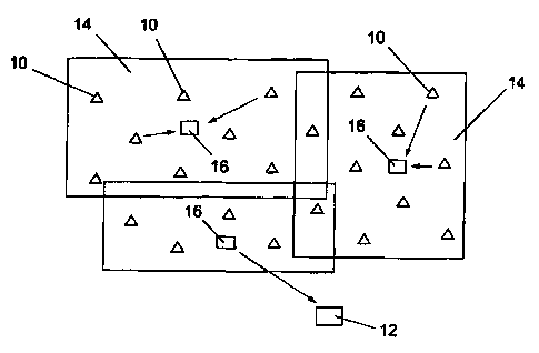
14 Referring to Fig. 1, a seismic survey across a
"prospect" or area of terrain of interest is conducted
16 by positioning a number of geophone units or remote
17 acquisition units (RAUs) 10 at known locations,
18 typically in a regular array. In the system of the
19 present invention, each RAU 10 can receive signals from
and transmit signals to a central control unit (CCU) 12
21 using wireless telemetry.
22
23 The array may be divided up into cells as indicated at
24 14 each with a transmitter/receiver or cell access node
(CAN) 16 acting as a relay between the RAUs 10 and the
26 CCU 12. This division may be required by the nature of
27 the terrain, but is advantageous in any event since it
28 allows the use of low power in the RAUs 10, thus
29 reducing size and cost.
31 Fig. 2 illustrates an individual RAU 10 which may be
32 used in the system of Fig. 1. The RAU 10 in Fig. 2
33 uses a single conventional geophone or strings) of
34 geophones to provide velocity information at 20 in
analogue form to an analogue to digital convertor 22
36 via a preamplifier and filter stage 21. The digitised
CA 02268939 1999-04-16
WO 98/18022 PCT/GB97/02924
1 information is stored at 24 for forwarding to the CAN
2 16 via a transmitter/receiver 26 in accordance with
3 control signals received from the CAN 16. These
4 control signals and the forwarding of the digital
5 information are by means of any suitable proprietary
6 protocol.
7
8 The RAU 10 also comprises a power supply 28 and control
9 circuitry 30. The power supply 28 suitably comprises
rechargeable or disposable batteries and preferably
11 also a solar panel.
12
13 Each of the RAUs 10 is identified by a unique code
14 which may be stored in a dedicated area of the store 24
as indicated at 24a.
16
17 The control circuitry 30 controls operation of the
18 preamplifier 21 in two ways.
19
First, the gain of the preamplifier 21 is adjusted as a
21 function of distance of the particular RAU 10 from the
22 location of the seismic signal source; this provides
23 more sensitivity at further distance from the source.
24 This adjustment may suitably be made and changed as the
location of the source is changed, the RAUs being
26 stationary.
27
28 Secondly, the gain may also be varied with time as the
29 return from the seismic signal source decays, with more
preamplification being used to boost the signal as it
31 decays. For example, an RAU close to the seismic
32 signal source could be set to have an initial gain of
33 2° which is used for the first second of the signal and
34 is increased to 21, 2z and 23 for each successive
second, whereas a distant RAU may be set with an
36 initial gain of 24, increasing to 25, 26 and 2'.
CA 02268939 1999-04-16
WO 98/18022 PCT/GB97/02924
6
1 These two factors are programmable from the CCU 12.
2
3 The control circuitry 30 also controls the operation of
4 the digital wireless telemetry such that the power
output is variable, allowing the number of RAUs 10
6 reporting to any given CAN 16 and the distance of any
7 RAU 10 from any given CAN 16 to be programmed, allowing
8 the design of the seismic surveys to be flexible.
9 These factors are also programmable from the CCU 12.
11 In operation, the CCU 12 transmits a signal to
12 indirectly activate the RAUs 10 prior to initiation of
13 the seismic signal source and each unit then stores
14 data for a given period after that signal. The CANS 16
poll their respective RAUs 10 causing each RAU to
16 transmit its stored information preceded by its
17 identity code. By using different frequencies in the
18 various cells 14, polling can proceed simultaneously in
19 each cell, with the CANS 16 communicating with the CCU
12 via a small number of broadband wireless links, or
21 data cable or fibre optic links.
22
23 In a modification, RAUs may be used which each comprise
24 two or more geophones operating with a single memory,
control circuitry and transmitter/receiver.
26
27 The shape and size of the cells is determined by the
28 range of the wireless transceiver, the terrain,
29 obstructions, and to a lesser extent the weather. The
RAUs in a given cell operate on one set of radio
31 frequencies. Adjacent cells operate on different
32 frequencies.
33
34 The telemetry system is able to re-use frequencies in
non-adjacent cells. Fig. 3 illustrates this with
36 reference to a survey area crossing a ridge (indicated
CA 02268939 1999-04-16
WO 98/18022 PCT/GB97/02924
7
1 by contour lines 37). Given that the radio
2 transceivers have a limited range, once outside that
3 range a given frequency can be re-used in another cell.
4 Thus radio frequencies can be re-used on a rolling
basis to minimise the number of frequencies required by
6 the system.
7
8 The radio system may particularly operate in the 2.4
9 GHz band at low power. High frequencies of this order
decay quickly with increasing distance, which allows a
11 limited number of frequencies to be used for an
12 unlimited number of cells. The 2.4 GHz band is
13 particularly preferred as this is a licence-free band
14 in many territories.
16 In the event of a CAN receiving signals from a number
17 of different cells, the system software can de-
18 duplicate the signals by deleting the weaker signals.
19
A suitable resolution will be obtained by each geophone
21 generating 24-bit information at a repetition rate of
22 500 Hz (2ms sample rate). The bandwidth requirement of
23 the polling system may be reduced by using known data
24 compression techniques in the RAUs 10 or CANS 16.
26 As one example, for a 24-bit sample at 2ms intervals,
27 the maximum data rate per geophone unit would be 12
28 kbits/s, and for a sector with eighty geophone units,
29 the sector base station would have a maximum data rate
of 1 Mbits/s. There are available low cost
31 radiotelemetry modules suitable for this data rate; for
32 example, the "Prism" radio chipset from Harris
33 Semiconductor Limited can handle up to 4 Mbit/s.
34
36 Fig. 4 shows one suitable form of CCU. Data is
CA 02268939 1999-04-16
WO 98/18022 PCT/GB97/02924
8
1 captured on a commercially available seismic
2 acquisition recording unit 44 of known type. This
3 issues timed shot commands at 46. Each shot command
4 causes a sync pulse generator 48 to generate a sync
pulse 1 to activate the geophones, and a series of
6 timed sync pulses 2i to control the polling. The sync
7 pulses are encoded and transmitted at 50 via a
8 transmit/receive switch 52, which also gates incoming
9 data signals to a receiver and decoder 54 to supply
data for the recording unit 44.
11
12 In a modification of the CCU, the sampling interval is
13 reduced stepwise in time. As one example, instead of
14 sampling every 2 ms for a total of 4s, the sampling
rate would be every 2 ms for the first second, every 4
16 ms for the next second, every 6 ms for the third
17 second, and every 8 ms for the fourth second. The
18 reason for this is that high frequency information is
19 attenuated with time in comparison with low frequency
information, and therefore the further one is away in
21 time from the input event the less high frequency there
22 is to be measured and the sampling rate can be reduced.
23
24 It is of course necessary for the CCU 12 to have
information defining the position of each of the RAUs
26 10. This may be achieved, as is currently done with
27 wired systems, by securing the RAUs 10 at positions
28 previously marked by conventional surveying. To assist
29 in loading information defining which RAU is at which
location, each RAU may conveniently be provided with an
31 external, machine-readable label such as a conventional
32 bar code with that unit's unique identity code. The
33 personnel installing the units can thereby enter the
34 location number and the corresponding geophone code in
a simple manner into portable recording apparatus for a
36 subsequent downloading into the central control 12.
CA 02268939 1999-04-16
WO 98/18022 PCT/GB97/02924
9
1 As an alternative, each RAU could include an electronic
2 positioning means which would enable the RAUs to be
3 positioned on the terrain without a preliminary survey
4 with the position of each RAU thereafter being
established by the CCU 12 by polling location data from
6 the RAUs 10. Such electronic positioning means could
7 be provided by a GPS system. Positional accuracy can
8 be improved by use of Differential GPS (DGPS). Rather
9 than incurring the expense of DGPS in each RAU, since
the RAUs are at fixed locations the positional
11 information can be loaded into the RAU when it is
12 installed; conveniently this could be done by infra-
13 red, radio or any other suitable means of short range
14 data transfer linking from a portable DGPS apparatus
which also includes the bar code reader.
16
17 Alternatively, the position of the CAN for each cell
18 could be fixed by a GPS receiver in the CAN, and the
19 relative position of each RAU with respect to its CAN
determined by a relatively simple local system.
21
22 It is likely that a dedicated wireless telemetry system
23 would require to be used, with one frequency to carry
24 commands from the CCU 12 indirectly to the various RAUs
10 and a number of separate frequencies to carry data
26 in reverse. In certain locations however it might be
27 possible to use systems similar to cellular telephones
28 for both commands and data.
29
Other modifications and improvements may be made to the
31 foregoing within the scope of the present invention, as
32 defined in the following claims.
33