Sélection de la langue

Search

Sommaire du brevet 2276361 

Énoncé de désistement de responsabilité concernant l'information provenant de tiers

Une partie des informations de ce site Web a été fournie par des sources externes. Le gouvernement du Canada n'assume aucune responsabilité concernant la précision, l'actualité ou la fiabilité des informations fournies par les sources externes. Les utilisateurs qui désirent employer cette information devraient consulter directement la source des informations. Le contenu fourni par les sources externes n'est pas assujetti aux exigences sur les langues officielles, la protection des renseignements personnels et l'accessibilité.

Disponibilité de l'Abrégé et des Revendications

L'apparition de différences dans le texte et l'image des Revendications et de l'Abrégé dépend du moment auquel le document est publié. Les textes des Revendications et de l'Abrégé sont affichés :

  • lorsque la demande peut être examinée par le public;
  • lorsque le brevet est émis (délivrance).
(12) Brevet: (11) CA 2276361
(54) Titre français: POSITIONNEMENT ACOUSTIQUE DE FLUTE SISMIQUE POUR FOND OCEANIQUE
(54) Titre anglais: ACOUSTIC POSITIONING OF SEISMIC OCEAN BOTTOM CABLE
Statut: Durée expirée - au-delà du délai suivant l'octroi
Données bibliographiques
(51) Classification internationale des brevets (CIB):
  • G01V 01/38 (2006.01)
  • G01V 01/18 (2006.01)
  • G01V 01/20 (2006.01)
  • G01V 01/28 (2006.01)
(72) Inventeurs :
  • CARROLL, PAUL ELLINGTON (Etats-Unis d'Amérique)
  • JAMES, ROY WILSON III (Etats-Unis d'Amérique)
  • BEDNAR, EUGENE DAVID (Etats-Unis d'Amérique)
  • RICE, CHARLES GEOFFREY (Etats-Unis d'Amérique)
  • BYERLY, KENT A. (Etats-Unis d'Amérique)
(73) Titulaires :
  • ION GEOPHYSICAL CORPORATION
(71) Demandeurs :
  • ION GEOPHYSICAL CORPORATION (Etats-Unis d'Amérique)
(74) Agent: CASSAN MACLEAN IP AGENCY INC.
(74) Co-agent:
(45) Délivré: 2007-07-17
(86) Date de dépôt PCT: 1998-10-29
(87) Mise à la disponibilité du public: 1999-05-14
Requête d'examen: 2003-10-07
Licence disponible: S.O.
Cédé au domaine public: S.O.
(25) Langue des documents déposés: Anglais

Traité de coopération en matière de brevets (PCT): Oui
(86) Numéro de la demande PCT: PCT/US1998/022943
(87) Numéro de publication internationale PCT: US1998022943
(85) Entrée nationale: 1999-06-29

(30) Données de priorité de la demande:
Numéro de la demande Pays / territoire Date
08/963,676 (Etats-Unis d'Amérique) 1997-10-31

Abrégés

Abrégé français

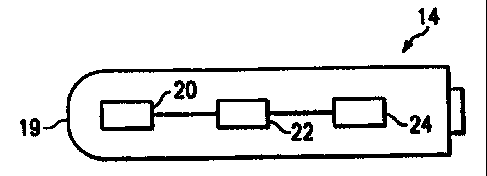
La présente invention concerne une flûte sismique pour fond océanique comprenant une suite de capsules sismiques (14) situées à intervalles réguliers le long d'un câble. Chaque capsule (14) comporte un hydrophone, un détecteur de mouvement tel qu'un géophone (22), et un circuit de positionnement acoustique (24). Un préamplificateur est couplé à un canal sismique. L'hydrophone (20) est également couplé au canal sismique. De plus, un canal acoustique est également couplé au préamplificateur et à l'hydrophone.


Abrégé anglais


A seismic ocean bottom
posi-tioning device includes a series of
seismic stations (14) spaced apart at
a predetermined interval along a
ca-ble. Each station (14) includes a
hydrophone, a motion sensing device
such as a geophone (22) and an
acous-tic positioning circuit (24). A
pream-plifier is coupled to a seismic channel.
The hydrophone (20) is also coupled to
the seismic channel. An acoustic
chan-nel is also coupled to the preamplifier and coupled to the hydrophone.

Revendications

Note : Les revendications sont présentées dans la langue officielle dans laquelle elles ont été soumises.


7
WHAT IS CLAIMED IS:
1. A seismic ocean bottom positioning system comprising:
a single acoustic transmitter supported on a first moving ocean surface
vessel;
a plurality of acoustic receiver units and modules spaced apart at intervals
along a
cable on the ocean bottom;
a first GPS receiver on the surface vessel;
a second GPS receiver operating from the first surface vessel, the position of
the
second GPS receiver being known with relation to the acoustic transmitter;
each receiver unit including a hydrophone, at least one geophone and an
acoustic
positioning circuit;
a seismic channel coupled to the hydrophone; and
an acoustic channel coupled to the hydrophone;
the receiver units being at an unknown depth with relation to the acoustic
transmitter; and
a second stationary surface vessel receiving data from the receiver units and
the
modules.
2. The system as defined in claim I further comprises a preamplifier, the
seismic
channel coupled to the preamplifier and the acoustic channel coupled to the
preamplifier.
3. A method of processing acoustic data for locating an acoustic receiver
positioned
on an ocean bottom comprising the steps of:
sending acoustic signals from a first surface vessel moving on a surface of a
body

8
of water;
receiving the acoustic signals in a stationary sensor unit including a seismic
channel and an acoustic channel each coupled to a common hydrophone and a
common
preamplifier;
processing the acoustic signals in a module adjacent each sensor unit; and
sending data from the processed signals to a second surface vessel in a
stationary
position on the surface of the body of water.
4. A sensor module for use in a marine seismic acquisition system, comprising:
a hydrophone;
a geophone operably coupled to the hydrophone, and
an acoustic positioning circuit operably coupled to the hydrophone including:
a preamplifier operably coupled to the hydrophone;
a seismic channel for processing seismic signals operably coupled to the
preamplifier including:
a slew limiter;
a low pass filter;
an analog-to-digital converter; and
a decimation filter; and
an acoustic positioning channel for processing acoustic signals operably
coupled
to the preamplifier including:
a high pass filter;
an acoustic amplifier; and

9
a signal detector.
5. A positioning device for use in a marine seismic acquisition system,
comprising:
a plurality of receiver stations spaced apart at intervals along a cable, each
station
including:
at least one hydrophone;
at least one geophone operably coupled to the hydrophone; and
an acoustic positioning circuit operably coupled to the hydrophone including:
preamplifier operably coupled to the hydrophone;
a seismic channel for processing seismic signals operably coupled to the
preamplifier including:
a slew limiter;
a low pass filter;
an analog-to-digital converter; and
a decimation filter; and
an acoustic positioning channel for processing acoustic signals operably
coupled
to the preamplifier including:
a high pass filter;
an acoustic amplifier; and
a signal detector.
6. A marine seismic acquisition system, comprising:
a seismic source;
an acoustic source; and

a sensing system operably coupled to the seismic and acoustic sources
including:
a plurality of receiver stations spaced apart at intervals along a cable, each
station
including:
at least one hydrophone;
at least one geophone operably coupled to the hydrophone; and
an acoustic positioning circuit operably coupled to the hydrophone including:
a preamplifier operably coupled to the hydrophone;
a seismic channel for processing seismic signals operably coupled to the
preamplifier including:
a slew limiter;
a low pass filter;
an analog-to-digital converter; and
a decimation filter; and
an acoustic positioning channel for processing acoustic signals operably
coupled
to the preamplifier including:
a high pass filter;
an acoustic amplifier; and
a signal detector.
7. The method of claim 3, wherein the acoustic signals are transmitted as a
pattern
of pulses.
8. The method of claim 3, wherein the acoustic signals are transmitted at two

11
frequencies.
9. The method of claim 3, wherein the acoustic signals are transmitted at
frequencies less than about 40 kHz.
10. The method of claim 3, wherein the acoustic signals provide a frequency
shift
keying signal.
11. The method of claim 3, wherein the acoustic signals are correlated against
a
predetermined code to determine the travel time of the acoustic signals.

Description

Note : Les descriptions sont présentées dans la langue officielle dans laquelle elles ont été soumises.


CA 02276361 1999-06-29
WO 99/23510 PCT/US98/22943
-1-
ACOUSTIC POSITIONING OF SEISMIC OCEAN BOTTOM CABLE
Background
The disclosures herein relate generally to seismic ocean bottom cables
and more particularly to locating the position of each hydrophone on the ocean
bottom.
One of the problems in seismic under-sea exploration is to locate the
receivers (hydrophones and or geophones) on the ocean bottom with respect to
a source of sound. The source of sound is located with respect to an
electronic
navigation system. The most commonly used navigation system is the
differential GPS (Global Positioning System) using satellites.
Existing systems now use an additional acoustic positioning system to
locate a towed cable and receivers (hydrophones). These systems usually do not
have an acoustic sensor at each hydrophone seismic sensor. The frequency used
is in the range of 30KHz to above 100KHz. A related problem in bottom cable
exploration is that if the sensor sinks into the mud at the ocean bottom, the
high frequency acoustic source may not penetrate the mud and may not work.
One such system is described in U.S. Patent 5,668,775 which includes
seismic equipment arranged to transmit and receive signals. The equipment
is included in streamers as part of a marine seismic tow. Furthermore, the
equipment uses several acoustic transmitters and operates with acoustic
receivers separated by a known distance. Also, the location of at least one
point
in a spatial network is defined by relating the network to at least one
conventionally determined geographical position.
Therefore, what is needed is a method and apparatus for determining the
position of seismic equipment placed on the ocean bottom rather than being
towed behind a boat such that the cables are in a fixed position on the ocean
bottom and a recording boat is maintained in position by anchoring or by
directional thrusters.

CA 02276361 1999-06-29
WO 99/23510 PCT/US98/22943
-2-
Summary
One embodiment, accordingly, provides a method and apparatus for a
bottom cable including several spaced apart hydrophones and an acoustic source
in a moving surface vessel capable of sending an acoustic signal to the near
hydrophones. To this end, a seismic ocean bottom positioning device comprises
a plurality of seismic stations spaced apart at intervals along a cable. Each
station includes a hydrophone, a motion detector device and an acoustic
positioning circuit. A seismic channel is coupled to the hydrophone and an
acoustic channel is coupled to the hydrophone.
A principal advantage of this embodiment is that the system uses one
positioning sound from a single source to precisely locate multiple receivers
in
a stationary position on the ocean floor.
Brief Description of Drawings
Fig. 1 is a diagrammatic view illustrating an embodiment of a seismic
ocean bottom cable system.
Fig. 2 is a diagrammatic view illustrating an embodiment of an
integrated sensor module.
Fig. 3 is a diagrammatic view illustrating an embodiment of a common
hydrophone and preamplifier coupled to a seismic channel and an acoustic
positioning channel.
Detailed Description of the Preferred Embodiment
In Fig. 1, an acoustic signal 10a is sent out from a moving shooting boat
on a surface 11 of ocean 12 by an acoustic source 13. An air gun array 21
is towed behind boat 10 and produces a seismic signal for a seismic survey
which may be conducted simultaneously in the well-known manner. Signals
from the acoustic source 13 are received by sensors 14 attached to sections of
a cable 15 at spaced apart intervals along the cable 15. Cable 15 is in a
stationary position on a bottom 16 of ocean 12. The acoustic signals l0a pass
directly through the water to the sensors 14, through some mud in the ocean
bottom 16 to the sensors 14 and also by a short refracted path to the sensors
14. Each cable section is attached to an ad;jacent cable section by an
electronic

CA 02276361 1999-06-29
WO 99/23510 PCT/US98/22943
-3-
module 17. The senors 14 process the acoustic signal received and produce a
seismic geophone signal and a seismic hydrophone signal. The acoustic signal
processed by sensors 14 indicates the time that the acoustic signal was
received.
The two seismic signals and the acoustic signal data are sent from the sensor
14 to an adjacent module 17. The module 17 filters and formats the signals and
sends them to an adjacent module 17. The module closest to a recording boat
18, in a stationary position on the surface 11, sends the signals to the
recording
boat 18 which gathers and records the data for later processing. Each sensor
14, Fig. 2, comprises an integrated sensor module 19 which includes a
hydrophone 20, exposed to ambient underwater pressure, a suitable motion
sensor which may be a vertical, gimbal mounted geophone 22, and acoustic
positioning circuitry 24, each of which are sealed off from ambient underwater
pressure.
The acoustic positioning circuitry 24 is distributed on PC boards in
module 19. The circuitry is diagrammatically illustrated in Fig. 3, wherein
common hydrophone 20 is used in connection with a seismic channe128 and an
acoustic positioning channel 30. In addition, a common preamplifier 32 is used
in connection with the seismic channe128 and the acoustic positioning channel
30. The seismic channel 28 includes a slew limiter 28a, an optional low-cut
filter 28b, an analog to digital converter 28c and a decimation filter 28d.
The
acoustic positioning channel 30 includes a high pass filter 30a, an acoustic
amplifier 30b and a signal detector 30c. Slew limiter 28a prevents high
frequency folding in an analog-to-digital converter. The low cut filter 28b is
optional and functions to get rid of low frequencies if so desired. The analog-
to-
digital converter 28c functions in the well-known manner. The decimation
filter
28d functions to produce a binary digital word representing the amplitude of
the seismic signal at a specific time. The high pass filter 30a functions to
attenuate a low frequency signal out of the acoustic channel. The acoustic
amplifier 30b functions to bring signals to a level suitable for detection.
The
signal detector 30c detects signals received from acoustic amplifier 30b.

CA 02276361 1999-06-29
WO 99/23510 PCT/US98/22943
-4-
Ordinarily, acoustic channel frequencies operate in the range of from
about 40 kHz to more than 100 kHz. In the present embodiment, the acoustic
channel frequency operates below 40 kHz in order to get some penetration into
the mud at the ocean bottom 16. This penetration allows the acoustic signal to
penetrate to the sensor which is dropped from the ocean surface 11 to the
ocean
bottom 16 and may penetrate into sediments such as mud on the ocean bottom
16. The use of frequencies that are too low will allow the acoustic signal to
travel too far in the bottom sediments, and due to refraction, may arrive
before
the direct path. Another reason to exclude the low frequency is the noise
generated by any boats that are nearby. It is clear that the optimum frequency
is a compromise between the refraction problem and the boat noise problem.
If the optimum frequency is too high, it will not reach a buried sensor.
Unfortunately, the optimum frequency will probably vary with the bottom
conditions from site to site.
It is therefore desirable to use one band of frequencies all of the time
because seismic bottom cable crews continuously move from one location to
another. The use of a single frequency simplifies the hardware but multiple
frequencies may be used to enhance the operation.
In order to reject boat noise, a signal switches between two frequencies
and a pulse pattern is used which enhances noise and multipath rejection. The
frequencies chosen are within the capabilities of commonly used transmitters
and transducers, and below the resonant frequency of the hydrophone 20.
The acoustic frequencies used are 13 kHz and 17 kHz and are a
compromise for purposes of this system. This technique will also have
application in acoustic steamer positioning. The use of a pulse pattern avoids
well known notch and multipath problems in transmission and assists in
rejecting noise. Different pulse patterns are used to minimize interference
from
other crews operating nearby, e.g. within 10 kilometers or less. This differs
from presently known methods which send pulses of different frequencies and
which use a frequency detector for each pulse. In the instant embodiment, two
frequencies are used and transitions are made between frequencies at a rapid

CA 02276361 1999-06-29
WO 99/23510 PCT11JS98/22943
-5-
rate (63 possible frequency changes in 16 milliseconds) to provide a unique
pattern that has a broad spectrum, so that a zero present in the spectrum, is
not a problem. The long duration of the pulse pattern contains more energy
than shorter, more powerful pulses. The received signal is correlated against
a known code to extract the travel time from the source to the receiver. It is
expected that a time accuracy of less than 100 microseconds will be attained
by
the use of differential GPS time at both the acoustic transmitter 13 and the
central electronics 26 which control the acoustic sensors 14. This embodiment
uses a long string of shifting frequencies and uses a correlation to collapse
the
pulse to determine the arrival time.
This embodiment describes a bottom cable 15 provided to locate the
position of each hydrophone 20 on the ocean bottom 16. A common hydrophone
and a common preamplifier are each used for both the seismic and acoustic
signals. The two signals, seismic and acoustic, which have substantially
different frequencies, are separated after the input stage and are conditioned
and processed separately.
The acoustic source 13 is positioned on the ocean surface 11, by the use
of GPS and the system measures the time from the acoustic source 13 to the
sensors 14. The source position changes constantly so each sensor 14 distance
is measured many times from different directions and distances. This permits
the location of the sensors 14 in x and y coordinates as well as a z
coordinate
for the depth of the water.
The source boat 10 tows the seismic source 21 behind it, including an air
gun array which also includes a GPS receiver 23. The source boat 10 also has
a GPS receiver 25, the position of which is known with relation to the
acoustic
source 13. The acoustic source 13 may be towed, installed through the boat
hull, as illustrated, or may be on a pole that is placed over the side of the
boat
10. The depth of the sensors 14 is known except for the variation due to the
rolling motion of the source boat 10.
As it can be seen, a principal advantage of this embodiment is that the
system uses one positioning sound from a single source to precisely locate

CA 02276361 1999-06-29
WO 99/23510 PCT/US98/22943
-6-
multiple receivers in a stationary position on the ocean floor. Bottom cable
acquisition provides higher quality data because the sensors are stationary
avoiding noise inherent in towed streamers. Data acquisition speed and
accuracy are also improved and a reduced amount of equipment is required.
Therefore, there are noticeable cost benefits.
Although illustrative embodiments have been shown and described, a
wide range of modifications, change and substitution is contemplated in the
foregoing disclosure and in some instances, some features of the embodiments
may be employed without a corresponding use of other features. Accordingly,
it is appropriate that the appended claims be construed broadly and in a
manner consistent with the scope of the embodiments disclosed herein.

Dessin représentatif
Une figure unique qui représente un dessin illustrant l'invention.
États administratifs

2024-08-01 : Dans le cadre de la transition vers les Brevets de nouvelle génération (BNG), la base de données sur les brevets canadiens (BDBC) contient désormais un Historique d'événement plus détaillé, qui reproduit le Journal des événements de notre nouvelle solution interne.

Veuillez noter que les événements débutant par « Inactive : » se réfèrent à des événements qui ne sont plus utilisés dans notre nouvelle solution interne.

Pour une meilleure compréhension de l'état de la demande ou brevet qui figure sur cette page, la rubrique Mise en garde , et les descriptions de Brevet , Historique d'événement , Taxes périodiques et Historique des paiements devraient être consultées.

Historique d'événement

Description Date
Inactive : Périmé (brevet - nouvelle loi) 2018-10-29
Inactive : Regroupement d'agents 2018-02-05
Inactive : Lettre officielle 2018-02-05
Lettre envoyée 2008-01-15
Accordé par délivrance 2007-07-17
Inactive : Page couverture publiée 2007-07-16
Préoctroi 2007-04-24
Inactive : Taxe finale reçue 2007-04-24
Un avis d'acceptation est envoyé 2007-01-24
Lettre envoyée 2007-01-24
Un avis d'acceptation est envoyé 2007-01-24
Inactive : CIB attribuée 2006-12-28
Inactive : Approuvée aux fins d'acceptation (AFA) 2006-12-06
Modification reçue - modification volontaire 2006-04-11
Inactive : CIB de MCD 2006-03-12
Inactive : Dem. de l'examinateur par.30(2) Règles 2005-10-11
Modification reçue - modification volontaire 2004-01-19
Lettre envoyée 2003-11-03
Exigences pour une requête d'examen - jugée conforme 2003-10-07
Toutes les exigences pour l'examen - jugée conforme 2003-10-07
Requête d'examen reçue 2003-10-07
Requête pour le changement d'adresse ou de mode de correspondance reçue 2002-12-06
Lettre envoyée 1999-12-01
Inactive : Transfert individuel 1999-11-02
Inactive : Page couverture publiée 1999-08-26
Inactive : CIB attribuée 1999-08-23
Inactive : CIB en 1re position 1999-08-23
Inactive : Lettre de courtoisie - Preuve 1999-08-17
Inactive : Notice - Entrée phase nat. - Pas de RE 1999-08-11
Demande reçue - PCT 1999-08-06
Demande publiée (accessible au public) 1999-05-14

Historique d'abandonnement

Il n'y a pas d'historique d'abandonnement

Taxes périodiques

Le dernier paiement a été reçu le 2006-10-02

Avis : Si le paiement en totalité n'a pas été reçu au plus tard à la date indiquée, une taxe supplémentaire peut être imposée, soit une des taxes suivantes :

  • taxe de rétablissement ;
  • taxe pour paiement en souffrance ; ou
  • taxe additionnelle pour le renversement d'une péremption réputée.

Les taxes sur les brevets sont ajustées au 1er janvier de chaque année. Les montants ci-dessus sont les montants actuels s'ils sont reçus au plus tard le 31 décembre de l'année en cours.
Veuillez vous référer à la page web des taxes sur les brevets de l'OPIC pour voir tous les montants actuels des taxes.

Titulaires au dossier

Les titulaires actuels et antérieures au dossier sont affichés en ordre alphabétique.

Titulaires actuels au dossier
ION GEOPHYSICAL CORPORATION
Titulaires antérieures au dossier
CHARLES GEOFFREY RICE
EUGENE DAVID BEDNAR
KENT A. BYERLY
PAUL ELLINGTON CARROLL
ROY WILSON III JAMES
Les propriétaires antérieurs qui ne figurent pas dans la liste des « Propriétaires au dossier » apparaîtront dans d'autres documents au dossier.
Documents

Pour visionner les fichiers sélectionnés, entrer le code reCAPTCHA :


Pour visualiser une image, cliquer sur un lien dans la colonne description du document (Temporairement non-disponible). Pour télécharger l'image (les images), cliquer l'une ou plusieurs cases à cocher dans la première colonne et ensuite cliquer sur le bouton "Télécharger sélection en format PDF (archive Zip)" ou le bouton "Télécharger sélection (en un fichier PDF fusionné)".

Liste des documents de brevet publiés et non publiés sur la BDBC .

Si vous avez des difficultés à accéder au contenu, veuillez communiquer avec le Centre de services à la clientèle au 1-866-997-1936, ou envoyer un courriel au Centre de service à la clientèle de l'OPIC.

({010=Tous les documents, 020=Au moment du dépôt, 030=Au moment de la mise à la disponibilité du public, 040=À la délivrance, 050=Examen, 060=Correspondance reçue, 070=Divers, 080=Correspondance envoyée, 090=Paiement})


Description du
Document 
Date
(aaaa-mm-jj) 
Nombre de pages   Taille de l'image (Ko) 
Dessin représentatif 1999-08-25 1 2
Description 1999-06-28 6 316
Revendications 1999-06-28 6 207
Abrégé 1999-06-28 1 52
Dessins 1999-06-28 1 34
Revendications 2006-04-10 5 103
Dessin représentatif 2007-06-28 1 3
Avis d'entree dans la phase nationale 1999-08-10 1 208
Courtoisie - Certificat d'enregistrement (document(s) connexe(s)) 1999-11-30 1 115
Rappel de taxe de maintien due 2000-07-03 1 109
Rappel - requête d'examen 2003-07-01 1 112
Accusé de réception de la requête d'examen 2003-11-02 1 173
Avis du commissaire - Demande jugée acceptable 2007-01-23 1 161
Correspondance 1999-08-16 1 15
PCT 1999-06-28 7 300
Correspondance 2002-12-05 2 58
Taxes 2000-10-18 1 32
Correspondance 2007-04-23 1 35
Courtoisie - Lettre du bureau 2018-02-04 1 33
Courrier retourné 2018-03-08 2 84