Note : Les descriptions sont présentées dans la langue officielle dans laquelle elles ont été soumises.
CA 02290118 1999-11-22
AUTOMATIC GUIDANCE SYSTEM FOR FLIGHT VEHICLE HAVING PARAFOIL AND
NAVIGATION GUIDANCE APPARATUS FOR THE SYSTEM
BACKGROUND OF THE INVENTION
1. Field of the Invention
This invention relates to an automatic guidance system
for a flight vehicle having a parafoil and a navigation guidance
apparatus for the system.
2. Description of the Related Art
Dropping of cargoes, weather observation, recovery of
unmanned flight vehicles and spacecraft using parachutes such as
ram-air parachutes, parafoils and the like, have often been made
because they can be made on even the unlevelled ground other than
runways.
However, dropping and recovery of cargoes by means of
flight vehicles having parafoils tend to be affected by wind and
as the actual descent position may be deviated from a target
descent position, the flight vehicle has been guided in the
direction of correcting the deviation by steering the paraf oil.
JP-A 5-185993, for example, describes such a guidance
apparatus as the related art for guiding purposes.
The guidance apparatus as disclosed in JP-A 5-185993 is,
as shown in a block diagram of Fig. 14, used to judge the present
traveling direction of a gliding flight vehicle using a controller
103 from the three-dimensional positions (X, Y and Z) of the flight
vehicle detected by a GPS 101 and the horizontal directions (Bx
- 1 -
CA 02290118 1999-11-22
and By) thereof detected by a geomagnetic sensor 102. Then a drive
signal ( V) is sent to a DC motor 104 in answer to the deviation
of its traveling direction from the direction of a preset target
descent position whereby to make the flight vehicle turn so that
the traveling direction may conform to the direction of the target
descent position by operating'the left or right control line 105
of a parafoil corresponding to the direction of correcting the
deviation.
In this guidance apparatus, position and attitude
detections are respectively made by the GPS 101 and the geomagnetic
sensor 102 at all times even when a flight vehicle P receives
lateral wind W while the flight vehicle having a parafoil is
traveling toward a target descent position 0. Thus, the guidance
apparatus keeps controlling the flight vehicle so as to direct
its traveling direction toward the target descent position as
shown by an arrow E by quickly correcting its attitude and course
even though the flight vehicle is on the course of receiving the
lateral wind as shown by a solid line in Fig. 15.
According to JP-A 5-185993, the course of the flight
vehicle can be corrected by correcting its position and attitude
at all times and even when the influence of the wind is exerted
upon the flight ve3iicle, its attitude can be corrected quickly.
Since the guidance is given in only correcting the
traveling direction to the direction of the target descent
position, there is fear that accuracy of descent will be lowered
- 2 -
CA 02290118 1999-11-22
considerably under the influence of moderate gale.
Accordingly, the selection of a flight path is important because
such a flight vehicle as is equipped with a parafoil is unable
to recover its altitude.
SUMARY OF THE INVENTION
The present invention is intended to obviate the
aforesaid problem of the related art and it is object of the present
to provide an automatic guidance system for a flight vehicle having
a parafoil and a navigation guidance apparatus for the system
designed to secure a proper flight path and make greater accuracy
of descent available.
In order to accomplish the object above, the invention
of an automatic guidance system for a flight vehicle having a
parafoil is such that the system for guiding the flight vehicle
having the parafoil to a target grounding point, the system
comprises the steps of : opening the paraf oil of the flight vehicle
dropped in a predetermined area above a grounding target point;
estimating wind velocity and wind direction after the parafoil
of the flight vehicle is opened; determining the landing flight
path of the flight vehicle based on the estimated wind velocity
and wind direction; guiding the flight of the flight vehicle to
the determined landing flight path; and making the flight vehicle
descend according to the landing flight path.
Further, the invention of a navigation guidance apparatus
- 3 -
CA 02290118 1999-11-22
for a flight vehicle having a parafoil is such that the apparatus
for guiding the flight vehicle having the parafoil to a target
grounding point, the apparatus comprises wind-velocity and
wind-direction estimating means for estimating wind velocity and
wind direction after the parafoil of the flight vehicle is opened;
land flight path determiningmeans for determining the landing
flight path of the flight vehicle based on the wind velocity and
wind direction estimated by the wind-velocity and wind-direction
estimating means; and flight control means for controlling the
paraf oil so that the flight vehicle descends according to a landing
flight path determined by the flight path determining means.
BRIEF DESCRIPTION OF THE DRAWINGS
FIG. 1 is a schematic diagram illustrating a flight
vehicle having a parafoil;
FIG. 2 is a block diagram illustrating a navigation
guidance apparatus;
FIG. 3A and 3B are a diagram illustrating a wind estimating
method;
FIG. 4 is a diagram illustrating a wind estimating method;
FIG. 5 is a diagram illustrating another wind estimating
method;
FIG. 6 is a diagram illustrating effect of wind;
FIG. 7 is a diagram illustrating an altitude adjusting
- 4 -
CA 02290118 1999-11-22
method;
FIG. 8 is a diagram illustrating another altitude
adjusting method;
FIG. 9 is a diagram illustrating a flight vehicle guidance
law;
FIG. 10 is a flowchart illustrating the operation of the
flight vehicle;
FIG. 11 is a diagram illustrating another flight vehicle;
FIG. 12 is a diagram illustrating still another flight
vehicle;
FIG. 13 is a diagram illustrating still another flight
vehicle;
FIG. 14 is a block diagram illustrating a conventional
guidance apparatus; and
FIG. 15 is a diagram illustrating the flight path of a
flight vehicle in the conventional guidance apparatus.
DETAILED DESCRIPTION OF THE PREFERRED EMBODIMENT
A detailed description will be given of an embodiment of
the present invention with reference to the attached drawings.
In Figs. 1- 13, there are shown an automatic guidance
system for a flight vehicle having a parafoil and a navigation
guidance apparatus for the system.
As shown in Fig. 1, a flight vehicle (hereinafter called
the 'airframe') 1 having a parafoil includes, for example, a
- 5 -
CA 02290118 1999-11-22
wing-like parafoil 2, a payload carrying frame 3 that is loaded
with main equipment, a number of suspension lines 4, and a left
and a right control line 5a and 5b (showing only one of them).
The payload carrying frame 3 is suspended by the parafoil 2 via
many suspension lines 4 in flight, and the lengths of tugging the
control lines 5a and 5b.are adjusted by a navigation guidance
control unit 10 mounted in the upper portion of the payload
carrying frame 3, so that the traveling direction is controlled.
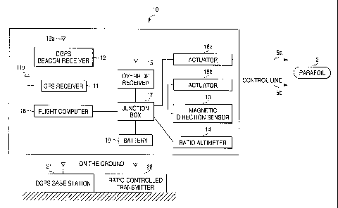
The navigation guidance control unit 10 includes, as
shown in Fig. 2, a GPS receiver 11, a DGPS beacon receiver 12,
a magnetic direction sensor 13, a radio altimeter 14, an override
receiver 15, a flight computer 16, a junction box 17, actuators
18a and 18b for DC motors and the like, and a battery 19. Antennas
lla and 12a are provided for the GPS receiver 11 and the DGPS beacon
receiver 12, respectively.
Apart from the navigation guidance control unit 10
mounted in the airframe 1, a DGPS base station 21 and a
radio-controlled transmitter 22 are installed on the ground.
The GPS receiver 11 together with the DGPS beacon receiver
12 functions as a DGPS for providing the ground speed and present
position of the airframe 1 in real time.
In the absence of the DGPS base station 21, the GPS is
usable alone. The magnetic direction sensor 13 is used to detect
the azimuth of the airframe, and the radio altimeter 14 to detect
the altitude thereof. These pieces of information are input to
- 6 -
CA 02290118 1999-11-22
the flight computer 16 and utilized as means for estimating the
wind velocity and wind direction. The flight computer 16 during
automatic flight functions as a means for determining a flight
path including speed, altitude, flight direction and the like to
be followed on the basis of the information thus acquired.
The flight computer 16 supplies control instructions to
the actuators 18a and 18b and functions as a flight control means
for adjusting the flight azimuth of the airframe 1 by adjusting
lengths of tugging the left and right control lines 5a and 5b to
turn the parafoil 2. With the control instruction to
simultaneously tug the left and right control lines 5a and 5b,
the flight computer 16 also operates to adjust a flight-path slope
including forward airspeed, descent velocity and the like.
Under instructions from the radio-controlled transmitter
22 operated by a radio controller on the ground, for example, the
override receiver 15 is used to give detailed guidance at the time
of emergency or landing. While this override function is actuated,
the instructions about operating the actuators 18a and 18b and
controlling the airframe 1 are issued from the radio-controlled
transmitter 22 and priority is given over the instructions of the
navigation guidance control unit 10 mounted in the airframe 1.
On the basis of the state quantity of the airframe 1
outputted from the DGPS, the magnetic direction sensor.13 and the
like, a flight maneuver to be taken now is determined by the flight
computer 16 so that the airframe may land at a target grounding
- 7 -
CA 02290118 1999-11-22
point when the altitude becomes zero and control instructions are
output to the actuators 18a and 18b in order to realize the
maneuver.
At the time of landing, there are important factors of
a guidance law of securing performance of implementing automatic
fixed point landing under any condition ranging from no-wind to
moderate gale exceeding the forward airspeed, the factors
including wind estimation, the effect of wind and altitude
processing.
A description will subsequently be given of the
aforementioned estimation of wind, consideration of the wind
effect and altitude adjustment in sequence.
(Wind Estimation)
In order to guide the airframe 1 in consideration of the
wind effect, it is needed to obtain values of wind velocity and
wind direction as accurate as possible in real time. Referring
to Figs. 3 and 4, there will be given the description of a wind
estimating method 1 by means of the DGPS or GPS alone as an example
of the wind estimating method.
The flight computer 16 is used to obtain two ground speed
vectors Vg as shown in Fig. 3A on the basis of information from
the override receiver 15, the DGPS beacon receiver 12, the DGPS
base station 21 or GPS receiver 11 alone by making the airframe
.1 do a steady turn. Then an intersecting point c between the
vertical bisector a of a straight line connecting the front ends
- 8 -
CA 02290118 1999-11-22
of the ground speed vectors Vg and a circle of ;Va; with the
end-to-end length of the ground speed vectors Vg as its radius
is mathematically obtained as shown in Fig. 3B. This point c is
the center of turn as seen from the atmosphere. An airspeed vector
Va necessary for use at this time may be an estimated value or
a measured value resulting from using an air data sensor capable
of measuring the airspeed vector Va of air.
In this case, there are two computed centers c of the
circle and it is difficult to determine whether or not the center
of the circle results from the actual turn only from data on the
two ground speed vectors. Therefore, the centers of the circle
estimated from data on several ground speed vectors are subjected
to statistical processing; specifically, what shows less
dispersion of estimated results of a plurality of centers of the
circle is used as an actual center of the circle. Consequently,
acquisition of a plurality of data points by making the airframe
1 have at least a half-turn is preferred.
The estimated center of the circle has the wind vector
Vw as shown in Fig. 4 and the wind estimation can be made by
estimating the center of the turning circle.
Fig. 5 shows a wind estimating method 2 by means of the
DGPS and magnetic direction sensor 13 as another example which
will be described below.
While the airframe 1 is making a linear flight, the ground
speed vectors Vg are then obtained on the basis of information
- 9 -
CA 02290118 1999-11-22
from the GPS receiver 11, the DGPS beacon receiver 12, the DGPS
base station 21 or GPS receiver 11 alone. Further, the azimuth
of the airframe 1 estimated by the magnetic direction sensor 13,
that is, a wind vector Vw is estimated from the traveling direction
and roughly calculated by the following equation. An estimated
value may be used for the airspeed vector Va that is needed at
this time or otherwise a measured value using the air data sensor
capable of measuring the airspeed vector Va of the air may also
be used then.
[Numerical Formula 1]
xw = Vg=sin(;bg)+Va=sin(;ba)
Yw = Vg=cos(tbg)+Va=cos(;ba)
Vw = VXw z +Yw 2
Ow = tan-' ( Xw/Yw)
Og: airspeed direction
Va: airspeed vector
Vg: ground speed vector
Vw: wind velocity
Xw: component X of ground speed
Yw: component Y of ground speed
(Consideration of the wind effect)
As the lift-drag ratio L/D of the airframe 1 is= basically
constant, the airspeed vector Va is also constant in the
quasi-equilibrium gliding condition and regardless of presence
- 10 -
CA 02290118 1999-11-22
or absence of wind, the forward speed and the descent velocity
relative to the air will not vary greatly. This guidance law is
not intended to guide the airframe 1 on the coordinates relative
to the ground but to guide the airframe 1 on the coordinates
relative to moving air, whereby greater accuracy of descent can
be attained with the same guidance law under any condition ranging
from no-wind to moderate gale exceeding the forward airspeed of
the airframe 1.
A quasi-target grounding point that is important in the
coordinates relative to the ground will be described by reference
to Fig. 6. The air mass and ground coordinates of guidance are
set so that the +direction of the Y-axis may directly face the
wind. While the ground coordinates are such that a target
grounding point A is fixed to the origin thereof, the air mass
coordinates move to the leeward (one direction) on the Y-axis of
the ground coordinates with the quasi-target grounding point B
always moved by the present altitude and wind velocity as an origin.
Although the quasi-target grounding point B is always offset to
the windward of the actual target grounding point A, this is due
to taking into consideration the movement of the atmosphere, that
is, the wind effect beforehand.
Even under any condition that the wind velocity exceeds
the forward airspeed of the airframe 1, the airframe 1 flying and
.landing backward can be prevented from being carried leeward from
the target grounding point A and failing to return thereto. The
- 11 -
CA 02290118 1999-11-22
relation of the quasi-target grounding point B to the ground
coordinates, that is, the distance D is expressed by the following
equation.
[Numerical Formula 2]
H = Va/-V( 1+(L/D).z
dT = H/ H
D = d T =Wsp
D: distance between quasi-target grounding point and
target grounding point
dT: time required for airframe to land from the present
altitude up to landing
H: present altitude
H: descent velocity (that is assumed to be constant)
(L/D): lift-drag ratio
Va: airspeed
Wsp: wind velocity
Consequently, the distance D decreases as the altitude
H lowers and when the altitude H becomes zero, that is, at the
point of time the airframe 1 lands, the quasi-target grounding
point B coincides with the actual target. Therefore, the airframe
1 can be guided theoretically without being'affected by the wind'
by guiding the airframe 1 to the quasi-target grounding point B
as the origin of the ground coordinates at all times.
- 12 -
CA 02290118 1999-11-22
(Altitude adjustment)
Altitude adjustment is important in view of securing
greater accuracy of descent of the airframe 1. However, the point
is how to process the altitude near the target grounding point
A with efficiency and there are a continuous and a race track turn
method, for example, for the altitude processing.
This continuous turn is the most efficient method of
processing the altitude that makes the most of the characteristics
of the paraf oil having a smaller turning radius than that of the
flight vehicle. As shown in Fig. 7, the altitude may be processed
on a substantially fixed point by continuously turning the
airframe 1 in the no-wind condition.
The airframe l is turned by tugging the left or right
control line 5a or 5b using the actuator 18a or 18b during the
time expected to be necessary for its turn.
The race track turn will subsequently be described. When
the airframe 1 is continuously turned while the wind exists under
a certain condition, the turning airframe 1 is carried leeward
at the same velocity as the wind velocity. While the airframe
1 is being continuously turned as shown in Fig. 8, the airframe
1 is periodically moved windward whereby to prevent the airframe
1 from unnecessarily departing from the target grounding point*
A according to this altitude processing method.
An example of the guidance law incorporating the wind
- 13 -
CA 02290118 1999-11-22
estimation, consideration of the wind effect and the factors of
altitude adjustment will subsequently be described with reference
to Fig. 9 and Fig. 10 that shows the operation of the airframe
1 according to a flowchart.
The guidance law is constituted of five phases including
wind estimation in phase.1; switching over to a nominal path, that
is, a landing flight path in phase 2; altitude adjustment in phase
3; a final approach in phase 4; and a final flare in phase 5. Each
phase together with the operation of the airframe will now be
described.
After the parafoil 2 is opened at Step S1, wind velocity
and wind direction are estimated at Step S2 in the phase 1; in
other words, the initial value of the wind is estimated on the
basis of the state quantity of the airframe obtained through the
wind estimating method 1 using the DGPS or GPS alone by steadily
turning the airframe 1 or the wind estimating method 2 using the
DGPS and the magnetic direction sensor 13 by linearly traveling
the airframe 1. The wind estimation is not limited to only the
phase 1 but made in any other phase whenever the airframe 1 is
steadily turned or linearly traveled so as to use the newest
estimated value at all times. Then the landing flight path is
determined by the flight computer 16 at Step S3 to determining
the flight path according to the wind estimation.
Subsequently at Step S4 to flight path guidance in the
phase 2, the airframe 1 is moved along the path running in the
- 14 -
CA 02290118 1999-11-22
same direction as the wind direction on the air coordinates. At
this time, the airframe 1 travels in a direction perpendicular
to the Y-axis of the air coordinates.
At a point of time the airframe 1 arrives at the landing
f light path or a position close to the landing f light path at Step
S 5 to changing the attitude, the airframe 1 is turned by tugging
the right or left control line 5a or 5b during the time expected
to be required for turning based on the turning performance thereof,
and the airframe 1 travels on the landing flight path toward the
leeward.
In the no-wind condition, the airframe 1 travels along
the landing flight path on the assumption that it has already
arrived at the landing flight path. At Step S6, the altitude
adjustment in the phase 3 is made at the point of time the airframe
1 reaches the leeward from the quasi-target point B on the air
coordinates. The landing flight path passes through the target
grounding point A and is set at a near position parallel to a wind
axis running in the same direction as the wind direction. The
airframe 1 is prevented from being unnecessarily brought to the
leeward by moving quickly onto the landing flight path.
At altitude adjustment Step S6, the airframe 1 enters the
phase 3, that is, the continuous and race track turns when it is
assumed necessary from the relation of the present position and
the target grounding point A whereby to process the altitude, and
descends while floating on the wind at path flight Step S7. The
- 15 -
CA 02290118 1999-11-22
altitude adjustment is basically made by the continuous turn.
However, when the wind exists, the race track turn is made
periodically as the airframe 1 floats leeward from the target and
by making the airframe 1 travel windward, whereby the airframe
1 is prevented from unnecessarily departing from the target.
The altitude adjustment in the phase 3 is intended to
minimize the ground speed at the time of landing and ease the impact
given to the payload and the final approach is made to direct the
airframe 1 to the windward. As the lift-drag ratio (L/D) is
constant, the flight path toward the target exists only one path,
so that the relation of the flight path of the final approach to
the present position of the airframe 1 is as shown in Fig. 9.
In other words, it is not advisable for the airframe 1
to unnecessarily travel away from the target, although the
airframe 1 is allowed to reach the target along the path shown
by a dotted line of Fig. 9. Therefore, the start point DWP of
the final approach of Fig. 9 is set close to the target by making
the altitude adjustment so as to reduce the unnecessary movement
of the airframe 1 to the leeward. Consequently, the flight path
after the altitude adjustment is as shown by a solid line of Fig.
9. The flight change Step S8 in the phase 4 is followed in a stage
where the start point DWP of the final approach becomes equal to
a preset threshold or lower.
In the phase 4, the final approach is made by directing
the airframe 1 windward in order to minimize the ground speed at
- 16 -
CA 02290118 1999-11-22
the time of landing and reduce the impact given to the payload.
The airframe 1 that has been traveling leeward prior to the phase
4 is caused to face the wind by 180 turning the airframe 1 and
made to travel toward the target while correcting an azimuth error
and a path angle error with respect to the target grounding point.
At landing Step: S9 in the phase 5, an altimeter such as
a radio altimeter is used to measure the relative distance between
the airframe 1 and a ground plane and when the measured value comes
to the threshold or lower, the airframe 1 is reduced in speed and
made to soft-land by subjecting the airframe 1 to full flare, that
is, tugging the control lines 5a and 5b by the same length.
Thus, the payload is fixed to the payload carrying frame
3 prior to flight, loaded in the aircraft and dropped at the drop
point set to ensure that the target grounding point is reached
from the present position in consideration of the wind velocity
and wind direction in the sky. The parafoil 2 opened by wind
pressure in the air suspends the payload and is guided by the
navigation guidance control unit 10 toward the target grounding
point while gliding in a substantially balanced attitude;
specifically, the airframe 1 is turned by tugging one of the left
and right control lines 5a and 5b using the actuators 18a and 18b
and landed at the target grounding point A accurately by changing
the azimuth of the airframe in a desired direction or
.simultaneously tugging both the control lines Sa and 5b.
Moreover, the present invention can be implemented by
- 17 -
CA 02290118 1999-11-22
suspending from the parafoil 2 an unmanned aircraft 51 as shown
in Fig. 11 or a spacecraft 52 as shown in Fig. 12 in place of the
payload carrying frame 3. Although a special navigation guidance
control unit 10 can be loaded in that case, equipment mounted in
the unmanned aircraft 51 or the spacecraft 52 is also usable.
It may also be arranged that the unmanned aircraft 51 or
the spacecraft 52 is made to travel toward a preset recovery area
and on arriving at the recovery area after the termination of a
predetermined flight or at the time of emergency, a parafoil-
opening point is set so that the aircraft or spacecraft can reach
the target recovery point based on the wind direction and velocity
detected by an installed airspeed sensor. Then the unmanned
aircraft or spacecraft can be guided and recovered in the same
manner as what has been described in the aforementioned embodiment
of the invention.
As shown in Fig. 13, further, the payload carrying frame
3 may be loaded with a payload 55 having an engine 57 with a
propeller 56, a fuel tank 58 and the like. At the time of taking
off , the airframe 1 rolls on the ground until the paraf oil 2 obtains
lift necessary for taking off from the thrust produced by the
propeller 56 and after taking off, it cruises up to a target place
like an ordinary aircraft. The traveling direction of the
airframe 1 is controlled by properly tugging the left and right
.control lines 5a and 5b using the actuators and the airframe 1
is guided to a target grounding point through the operation
- 18 -
CA 02290118 1999-11-22
described in the above embodiment of the invention after arrival
at the target place.
While only certain embodiments of the invention have been
specifically described herein, it will apparent that numerous
modification may be made thereto without departing from the spirit
and scope of the invention.
As described the above, according to the first aspect of
the invention, there is provided an automatic guidance system for
guiding a flight vehicle having a parafoil to a target grounding
point, comprising the steps of : opening the parafoil of the flight
vehicle dropped in a predetermined area above a grounding target
point; estimating wind velocity and wind direction after the
paraf oil of the flight vehicle is opened; determining the landing
flight path of the flight vehicle based on the estimated wind
velocity and wind direction; guiding the flight of the flight
vehicle to the determined landing flight path; and making the
flight vehicle descend according to the landing flight path.
In the invention of the first aspect, the wind velocity
and wind direction are estimated after the parafoil of the flight
vehicle dropped in the predetermined area above the grounding
target point is opened and the landing flight path of the flight
vehicle is determined based on the estimated wind velocity and
wind direction. Then the flight vehicle is made to descend along
the determined landing flight path and accordingly an optimum
landing flight path corresponding to the estimated wind velocity
- 19 -
CA 02290118 1999-11-22
and wind direction is secured, whereby greater accuracy of descent
can be attained.
According to the second aspect of the invention, there
is provided an automatic guidance system for a flight vehicle
having a paraf oil to a target grounding point comprises the steps
of: opening the parafoil of 'the flight vehicle dropped in a
predetermined area on the windward of and above a grounding target
point; estimating wind velocity and wind direction after the
parafoil of the flight vehicle is opened: determining a landing
flight path according to which the flight vehicle descends from
the windward to the leeward based on the estimated wind velocity
and wind direction; guiding the flight of the flight vehicle to
a position close to the determined landing flight path; changing
the attitude of the flight vehicle so as to direct the flight
vehicle to the leeward in the position close to the landing flight
path; adjusting the altitude of the flight vehicle; making the
flight vehicle with its altitude adjusted descend from the
windward to the leeward according to the landing flight path; and
making the flight vehicle land by changing the attitude of the
flight vehicle so as to direct the flight vehicle windward on the
leeward of the target grounding point.
In the second aspect of the invention, which has
materialized the first aspect of the invention, the step of
adjusting the altitude of the flight vehicle is provided in
addition to the first aspect of the invention. Accordingly, the
-20-
CA 02290118 1999-11-22
flight vehicle is prevented from excessively floating leeward.
Moreover, the flight vehicle is made to land by changing the
attitude of the flight vehicle so as to direct the flight vehicle
windward on the leeward of the target grounding point, whereby
a landing impact is eased because the landing speed is suppressed.
According to the third aspect of the invention, in the
automatic guidance system in the first aspect or the second aspect
of the invention, the estimation of the wind velocity and wind
direction is calculated by the ground speed of the flight vehicle
obtained by GPS or DGPS.
In the third aspect of the invention, the wind velocity
and wind direction are efficiently estimated by the ground speed
of the flight vehicle obtained by GPS or DGPS.
According to the fourth aspect of the invention, in the
automatic guidance system in the first aspect or the second aspect
of the invention, the estimation of the wind velocity and wind
direction is calculated by the ground speed of the flight vehicle,
and the azimuth and airspeed of the flight vehicle obtained by
GPS or DGPS.
In the fourth aspect of the invention, the wind velocity
and wind direction are efficiently estimated by the ground speed
of the flight vehicle and the azimuth and airspeed of the flight
vehicle obtained by GPS or DGPS.
According to the fifth aspect of the invention, in the
automatic guidance system in the second aspect of the invention,
- 21 -
CA 02290118 1999-11-22
the altitude adjustment of the flight vehicle is made by a
continuous turn of the flight vehicle.
In the fifth aspect of the invention, the altitude
adjustment of the flight vehicle is easily made by a continuous
turn of the flight vehicle effectively utilizing the
characteristics of the parafoil.
According to the sixth aspect of the invention, there is
provided a navigation guidance apparatus for a flight vehicle
having a paraf oil is such that the apparatus for guiding the flight
vehicle having the paraf oil to a target grounding point comprises
wind-velocity and wind-direction estimating means for estimating
wind velocity and wind direction after the parafoil of the flight
vehicle is opened; land flight path determining means for
determining the landing flight path of the flight vehicle based
on the wind velocity and wind direction estimated by the
wind-velocity and wind-direction estimating means; and flight
control means for controlling the parafoil so that the flight
vehicle descends according to a landing flight path determined
by the flight path determining means.
In the sixth aspect of the invention, the provision of
the wind-velocity and wind-direction estimating means for
estimating wind velocity and wind direction, land flight path
determining means for determining the landing flight path of the
flight vehicle based on the wind velocity and wind direction, and
flight control means for controlling the parafoil so that the
- 22 -
CA 02290118 1999-11-22
flight vehicle descends according to the landing flight path makes
the automatic guidance system of the first aspect to the fifith
aspect of the invention attainable with efficiency.
According to the seventh aspect of the invention, in the
navigation guidance apparatus in the sixth aspect, the wind-
velocity and wind-direction estimating means includes a GPS
receiver and a flight computer. for estimating the wind velocity
and wind direction based on ground speed vectors obtained by the
GPS receiver.
In the seventh aspect of the invention, the flight
computer is used to estimate the wind velocity and wind direction
based on the ground speed vectors obtained by the GPS receiver
as the flight vehicle travels.
According to the eighth aspect of the invention, in the
navigation guidance apparatus in the sixth aspect of the invention,
the wind-velocity and wind-direction estimating means includes
a GPS receiver, a magnetic direction sensor for detecting the
azimuth of the flight vehicle, and a flight computer for estimating
the wind velocity and wind direction based on ground speed vectors
obtained by the GPS receiver, the azimuth of the flight vehicle
and the airspeed of the flight vehicle obtained by the magnetic
direction sensor.
in the invention of the eight aspect of the invention,
the flight computer is used to estimate the wind velocity and wind
direction based on the ground speed vectors obtained by the GPS
- 23 -
CA 02290118 1999-11-22
receiver, the azimuth of the flight vehicle and the airspeed of
the flight vehicle obtained by the magnetic direction sensor.
According to the ninth aspect of the invention, in the
navigation guidance apparatus as in either the seventh aspect or
eighth aspect of the invention, the apparatus uses a DGPS beacon
receiver in addition to.,the GPS receiver.
In the invention of the ninth aspect of the invention,
the use of the DGPS beacon receiver in addition to the GPS receiver
makes available the ground speed vectors with accuracy and also
allows the wind velocity and wind direction to be estimated with
accuracy.
According to the tenth aspect of the invention, in the
navigation guidance apparatus as in one of the seventh aspect to
the ninth aspect of the invention, the flight path determining
means is the flight computer for determining the flight path based
on the wind velocity and the force of the wind that have been
estimated and wherein the flight control means are actuators for
tugging the control lines of the parafoil under the control of
the flight computer.
In the tenth aspect of the invention, the flight path
determining means is constituted of the flight computer and the
flight control means are constituted of the flight computer and
actuators for tugging the control lines of the parafoil.
- 24 -