Note : Les descriptions sont présentées dans la langue officielle dans laquelle elles ont été soumises.
CA 02332264 2000-11-14
WO 99/58933 PGT/US99I10633
APPARATUS FOR MEASURING MAGNETIC DECLINATION USING GPS
FIELD OF THE INVENTION
The invention relates to an apparatus to measure the local gravity and
magnetic
io fields in conjunction with position determinations using Global Positioning
System (GPS)
sensors. Spec~cally, it relates to an apparatus and method used to determine
the local
magnetic field strength, declination and dip angle at a site in the proximity
of a drillsite to
facilitate the drilling of deviated holes in exploration and development of
hydrocarbon
reservoirs.
BACKGROUND OF THE INVENTION
In the drilling of wells in hydrocarbon exploration and development, it is
common to
drill boreholes that deviate signficantly from the vertical. The drillbit in
such deviated holes
2 o is controlled to make the trajectory of the wellbore follow a desired
trajectory to intersect
producing reservoirs at desired locations. Various surveying techniques are
used to
determine the position of the wellbore. In addition to inertial and gravity
measurements,
these techniques include determination of the direction of the earth's
magnetic field.
2s The magnetic surveys are referenced to the magnetic north direction, i.e.,
the
direction approximately defined by a magnetic compass. Most people incorrectly
believe
that a compass needle points to the north magnetic pole. But since the Earth's
field is the
effect of complex convection currents in the magma, which must be described as
several
1
CA 02332264 2003-02-28
WO 99/58933 PCTNS99/10633
- dipoles, each with a different intensity and orientation, the compass
actually points to the
sum of the effects of these dipoles at any location. In other words, it aligns
itself with the
magnetic lines of force. Other factors, of local and solar origin, further
complicate the
resulting field. It may be all right to say that a compass needle points
"magnetic north" but
s it only roughly points to the north magnetic dipole.
Predictive geomagnetic models such as the World Magnetic Model (WMM) and the
lntemational Geomagnetic Reference Field (IGRF) only predict the values of
that portion of
the field originating in the deep outer core. In this respect, they are
accurate to within one
io degree for five years into the future, after which they need to be updated.
The Definitive
Geomagnetic Reference Field (DGRF) model describes how the field actually
behaved.
Numerous publications give values of the magnetic declination using these
models. These
include the 1:39,000,000 Magnetic; Variation chart of 'The Earth's Magnetic
Field" series
published by the Defense Mapping Agency (USA), 'The World Magnetic Variation
1995
is and Annual Rates of Change" chart published by the British Geological
Survey, and a
1:48,000,000 world declination chart of "The Magnetic Field of. Earth" series
that is
published by the United States Geological Survey's Earth Sciences Information
Center.
Local anomalies originating in the upper mantle, crust, or surface, distort
the WMM
20 or IGRF predictions. Ferromagnetic ore deposits; geological features,
particularly of
volcanic origin, such as faults and lava beds; topographical features such as
ridges,
trenches, seamounts, and mountains; ground that has been hit by lightning and
possibly
harboring fulgurites; cultural features such as power lines, pipes, rails and
buildings;
personal items such as crampons, ice axe, stove, steel watch, hematite ring or
even a belt
zs buckle, frequently induce an error o~ three to four degrees.
2
CA 02332264 2000-11-14
WO 99/58933 PCT/US99/10633
The stream of ionized particles and electrons emanating from the Sun, known as
solar wind, distorts the Earth's magnetic field. As it rotates, any location
will be subject
alternately to the lee side, then the windward side of this stream of charged
particles. This
s has the effect of moving the magnetic poles around an ellipse several tens
of kilometers in
diameter, even during periods of steady solar wind without gusts. The
resulting diurnal
change in declination is relatively small at tropical and temperate latitudes
compared to the
effect of local anomalies. For example, Ottawa is subject to plus or minus 0.1
degree of
distortion. However; in Resolute, 500 kilometers from the north magnetic pole,
the diurnal
io change cycles through at least plus or minus nine degrees of declination
error. This error
could conceivably be corrected, but both the time of day and the date would
have to be
considered, as this effect also varies with seasons.
The solar wind varies throughout an 11-year sunspot cycle, which itself varies
from
i5 - one cycle to the next. During severe magnetic storms, compass needles at
high latitudes
have been observed swinging wildly.
In typical downhole surveys, the position of the borehole is determined to
within an
accuracy of 3 ft per 1000 ft. of lateral displacement relative to the top of
the borehofe. Even
2o a 1 degree error in the magnetic declination used in the survey makes an
error of over 15
feet in lateral displacement at an offset of 1000 ft. This can be problematic
in the case of
wells drilled over a period of several years in the development of a field. in
addition, leases
including OCS lease sales periodically conducted by the United States
Government involve
the leasing of tracts designated in terms of geographic coordinates. It is
important in the
25 development of fields that any wellbore survey carried out using a magnetic
reference be
3
CA 02332264 2000-11-14
WO 99/58933 PCT/US99/10633
referred back to geographic directions and coordinates.
Magnetic borehole survey instruments measure direction with respect to the
local
magnetic field. All magnetic surveys are subject to errors if the horizontal
component of the
s local magnetic field is not aligned with the local magnetic north. Errors of
this kind may be
caused by distortion of the local magnetic field by magnetic BHA materials in
the borehole.
Drillstring conveyed magnetic survey tools ace usually run inside non-magnetic
drill collars.
However, it is not unusual for the measurement to be influenced by adjacent
magnetic
drillstring material. Therefore, frequent use is made of techniques to detect
and
to subsequently remove errors due to drillstring magnetization. These
techniques rely on the
principle of having accurate earth's field data available, i.e. local earth's
magnetic field
strength and local earth's magnetic dip angle. Hence this invention also
provides a
technique to provide accurate local earth's field data to allow to correct the
data due to
magnetic interference.
The "Mag-01 H declinometerlinclinometer' of Bartington Instruments comprises a
single axis fluxgate magnetometer, with the magnetometer sensor mounted on a
non-magnetic optical theodolite. As is noted in the description provided by
Bartington
Instruments:
"The magnetic axis of the sensor is aligned with the optical telescope of the
theodolite and only records the strength of the component of the field along
that
axis. The theodolite is carefully leveled and the magnetic sensor axis is set
to the
horizontal position and rotated until a null is observed in the magnetic
field. At this
position the sensor is exactly normal to the earth's magnetic field and from
the
2s theodolite reading the direction of the field in the horizontal plane can
be
4
CA 02332264 2000-11-14
WO 99/58933 PCT/US99/10633
established. The true north direction is determined from solar or star
observation or
using a gyroscope, and the declination can then be calculated."
The necessity of establishing the true north direction from astronomical
observations
s complicates the determination of magnetic declination. In addition, the
theodolite
observations noted above require human interaction while the use of a
gyroscope has its
own problems, particularly those associated with calibration and drift of the
gyroscope.
The best navigational tool available for determining the position of an
observation
io point on the surface of the earth is based on signals from Global
Positioning System (GPS)
satellites. Most GPS receivers have internal data and an algorithm to compute
the
declination after the position is established. The algorithm is based upon
models such as
the IGRF model and does not account for local and temporal variations. In any
case, this
data cannot be updated from satellite transmission, therefore it is subject to
become
i 5 outdated.
Accordingly, there is a need for an invention that determines the local
Earth's
magnetic field, local dip angle and declination at a borehole with a high
degree of accuracy
with a minimum of human intervention. Such an invention should preferably also
have the
2o capability of tracking the time-varying component of the magnetic field,
i.e. local magnetic
field, local dip angle and declination, whether it is caused by diurnal
variation or by
geomagnetic storms.
CA 02332264 2003-02-28
SUMMARY OF THE INVENTION
The present invention is an apparatus and a method far determination of the
local earth's magnetic field, local earth's dip angle and declination. A
platform made
of nonmagnetic material is located at a distance of 100 to 200 ft. from the
wellsite.
Based upon observations at a pair of GPS receivers at apposite ends of the
platform,
a processor determines the orientation of the longitudinal axis of the
platform with
respect to due north. Near the center of the platform, a 3-component
magnetometer
is used to provide a measurement of the magnetic field of the earth and give
its
direction with respect to the axis of the platform. A 3-component
accelerometer
provides measurements of the roll and tilt of the platform. A processor
analyzes the
data to determine the angle that the axis of the platform makes with the
horizontal
component of the earth's magnetic field and thence the magnetic declination. A
photon magnetometer that provides a measurement of the total magnetic field
serves
1~ as a check on the 3-component magnetometer. In addition, three
supplementary
single component magnetometers are used for quality control. For use in marine
applications, the rig is on a drillship arid the stable platform is tethered
to buoys away
from the drillship. The platform is provided with an inertial navigation
sensor, the
output of which are used to correct for motion of the platform.
In one aspect of the present invention there is provided an apparatus
including two spaced apart G lobal Positioning Sensor (GPS) receivers adapted
to
receive electromagnetic signals from a plurality of satellite positions, and a
3-
component magnetometer measuring three independent components of the earth's
magnetic field and providing signals indicative thereof, far determination a
parameter
of interest at a location on the earth, the apparatus comprising:
(a) a non-magnetic platform for providing a stable base for said at least
two GPS receivers and said magnetometer;
(b) an additional sensor far providing a signal indicative of a roll angle of
said platform, said additional sensor selected from (i) a 3-component
accelerometer on the non-magnetic platform for measuring three
independent components of acceleration and providing signals
indicative thereof; and, (ii) an additional GPS receiver spaced apart
from and non- collinear with said at least two GPS receivers; and
6
CA 02332264 2003-02-28
(c) a processor for processing signals from the at least two GPS
receivers, the 3-component magnetometer, and the additional sensor
and determining therefrom the parameter of interest.
.5 In another aspect of the present invention there is provided a method for
determination of a parameter of interest at a location on the earth using at
least two
spaced apart Global Positioning Sensor (GPS) receivers receiving signals from
a
plurality of satellites, and a ;:.-component magnetometer providing signals
indicative
of three components of earth's magnetic field, the method comprising:
(a) locating said GPS receivers and said magnetometers on a
nonmagnetic platform
(b) using an additional sensor on the non-magnetic platform for obtaining
a signal indicative of a roll angle of the platform, said additional sensor
selected from (i) a 3-component accelerometer on the platform, and,
1.5 (ii) a GPS receiver non-collinear with said at least two GPS receivers;
and
(e) using a processor to process the signals from the at least two GPS
receivers, the 3-component magnetometer and the additional sensor
to determine tine parameter of interest.
BRIEF DESCRIPTION OF THE DRAWINGS
For a detailed understanding of the present invention, reference should be
made to the following detailed description of the preferred embodiment, taken
in
2~ conjunction with the accompanying drawings, in which like elements have
been given
like numerals, wherein:
6a
CA 02332264 2000-11-14
WO 99/58933 PCT/US99/10633
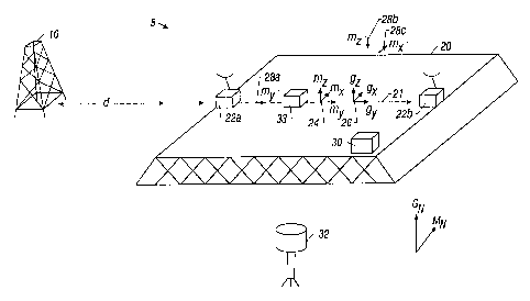
FIG.1 shows a schematic view of the apparatus of the present invention.
DETAILED DESCRIPTION OF THE INVENTION
The main component parts of the present invention are illustrated in FIG. 1. A
drilling rig 10 is shown on the surface of the earth 5. At a distance d from
the drilling rig, a
stable platform 20 is located, the platform having a longitudinal axis
generally indicated by
21. The distance d is typically between 100 and 200 feet. The platform is made
of a non-
io magnetic material, such as fiberglass, to avoid the introduction of any
local magnetic
perturbations.
Also located on the platform are at least two GPS receivers, indicated here by
22a
and 22b. In the illustration, without limitation, they are shown as being
positioned along the
is longitudinal axis of the platform. Those versed in the art would recognize
that as long as
the two GPS receivers 22a and 22b are on a line whose orientation to the
longitudinal axis
of the platform is known, the invention as described below would still
function.
Located on the surface of the platform is a 3-component magnetometer,
indicated
2o here by 24. For purposes of illustration, the three components (mL m,, and
mx) of the
magnetic field of the earth measured by the magnetometer 24 are indicated by
arrows as
being perpendicular to the surface of the platform, along the longitudinal
axis of the platform
and at right angles to the longitudinal axis of the platfom7. These three
components are
orthogonal to each other. Also located on the surface of the platform is a 3-
component
7
CA 02332264 2000-11-14
WO 99/58933 PCT/US99/10633
accelerometer 26 that measures the components of gravity gx , gY and gZ in the
x, y, and z
directions.
A processor 30 that may be located on or in the vicinity of the platform,
receives
s signals from the GPS receivers 22a and 22b, the magnetometer 24 and the
accelerometer
26. The signals may be transmitted by any suitable telemetry means, including
wires, fiber
optics or by radio transmission. The method of determining the attitude of the
GPS
receivers with respect to each other is based upon the NAVSTAR GPS based
Attitude
Determination System incorporated in a product sold under the mark STINGRAY~
by
io Collins Avionics and Communications Division of Rockwell. A summary of the
technique
used to determine the attitude of the two GPS receivers is given here.
The absolute phase of the GPS carrier frequency can be measured in an accuracy
of better than 11100 of a wavelength. The GPS signal designated as L1 has a
wavelength
i5 of about 19 cm. and the GPS signal designated as L2 has a wavelength of 25
cm.
Accordingly, relative carrier phase measurements utilizing differential
carrier phase
techniques (interferometry) accurately determine the relative position between
the two
antennas to an accuracy of the order of 1 mm.
2o Since the carrier has no ranging information, the range to a particular
satellite
consists of the measured fractional carrier phase plus an unknown number of
carrier
cycles. This is called the carrier cycle ambiguity. In STINGRAY~ , a first
phase difference
is formed for the two receivers and a single satellite. This is repeated for a
second satellite
to give a second phase difference. A double difference is computed between the
first and
8
CA 02332264 2000-11-14
WO 99/58933 PCT/US99/10633
second phase difference that is related to the known distance between the two
receivers.
By performing this for four different satellites, a unique solution for the
attitude of the two
receivers with respect to each other is obtained. Rockwell claims that the
solutions may be
obtained in less than one second when the two receivers are one meter apart
while several
s seconds are required to obtain a solution for longer baselines.
Note that the plurality of satellites required for this process in the present
invention
does not require that all satellites be in view simultaneously. The platform
is known to be
stationary, so that multiples passes of the same satellite, or of less than
four satellites
?o suffices to determine the attitude of the platform.
One aspect of the present invention uses the product STINGRAY~ in a embedded
configuration with two GPS antennas and the necessary cabling and interface to
implement
the additional features of the present invention. Using two antennas provides
an estimate
i5= of only two of the parameters characterizing the line joining the two
receivers: these are the _
yaw angle (corresponding to the azimuth) and the tilt angle. In the present
invention the
processor 30 also receives signals from the accelerometer 26. These provide
estimates of
the roll and tilt of the platform using methods known in the art.. Thus, the
tilt angle is
measured redundantly. An additional level of redundancy is provided in the
invention by
Zo the measurements made by a proton magnetometer 32 that is part of the
measurement
assembly. The proton magnetometer 32 gives the total magnetic field intensity.
This
serves as a check on the three components measured by the magnetometer 24: the
magnitude of the vector sum of the three components measured by the
magnetometer 24
must equal the value measured by the proton magnetometer 32. The yaw angle of
the
25 platform as determined by the processor gives the orientation of the
platform with respect to
9
CA 02332264 2000-11-14
WO 99/58933 PCT/US99/r 0633
geographic north. The difference between this and the direction of the
horizontal
component of the earth's magnetic field, as determined from the magnetometer
measurements gives a measurement of the declination at the platform with an
accuracy of
0.1°. This is a considerable improvement over prior art methods.
Another embodiment of the invention uses more than two GPS receivers an-anged
so that they do not lie on a straight line. This makes it possible to
determine all three
angles characterizing the fixed platform just from the GPS measurements. In
such a case,
the accelerometers provide redundant measurements that may be used to make
more
i o accurate estimates of the orientation of the platform. As discussed above,
the yaw angle
gives the geographic north direction.
Those versed in the art would appreciate that with the invention as described
above,
it is possible to get measurements of the local magnetic field, local dip
angle and
is declination in a relatively short time. This makes it possible to track
any.temporal variation
in the local earth's magnetic field, local earth's dip angle and declination
due to causes
discussed above. A borehole magnetic survey conducted using conventional
apparatus
could then be corrected to give a downhole survey referenced to geographic
coordinates
by applying the time-varying corrections determined by the apparatus and
method
2 o discussed above.
The present invention also includes three single component magnetometers
labeled
28a, 28b and 28c that are at locations displaced in the y, z and x directions
from the
magnetometer 26. Differences between values measured by these three single
component
CA 02332264 2000-11-14
WO 99/58933 PCT/US99/10633
magnetometers and the corresponding components measured by magnetometer 26
gives a
measurement of the local magnetic field gradient. This serves as a quality
control
measurement. For example, a bucket of nails placed near the platform
inadvertently will
provide a large change in the magnetic gradient that is easily detectable and
appropriate
s remedial steps can be taken.
For use in offshore applications, a second embodiment of the invention is
used. In
such applications, the rig 10 is carried on a drillship (not shown). Such
dril)ships are
inherently made of magnetic materials such as steel, and to avoid the magnetic
~o disturbances caused by the drillship, the platform 10 is tethered to one or
more buoys (not
shown) at a distance d from the rig. However, the marine environment causes a
second
problem: due to wave. motion, the platform will be in motion, thus rendering
the assumptions
made in the discussion of the land-based system erroneous. In particular, GPS
positioning
measurements are particularly susceptible to errors caused by heave of the
platform,
is
The embodiment used in a marine environment includes an Inertial Measurement
Unit (IMU) 33 on the platform. The IMU comprises an inertial grade Gyro
Platform that
provides accurate measurements relating to the motion of the platform. The
processor 30
is preferably located on the drillship. Those versed in the art would
recognize that GPS
2o measurements may not be available continuously, so that in the marine
environment, the
processor uses the measurements from the GPS receivers 22a and 22b and
discrete times,
and the processor 30 applies a Kalman filter to the GPS receiver data and the
motion data
from the IMU to give filtered indications of the position and velocity of the
platform. The
data from the GPS receivers 22a and 22b are relatively insensitive to heaving
motion of the
2s platform and the processor uses the data from the IMU 33 to obtain accurate
estimates of
11
CA 02332264 2000-11-14
WO 99/58933 PCT/US99/10633
heave. The use of a Kalman filter to make such determinations would be known
to those
versed in the art.
The foregoing description has been limited to specific embodiments of this
invention.
s It will be apparent, however, that variations and modifications may be made
to the
disclosed embodiments, with the attainment of some or all of the advantages of
the
invention. Therefore, it is the object of the appended claims to cover all
such variations
anti modifications as come within the true spirit and scope of the invention
12