Note : Les descriptions sont présentées dans la langue officielle dans laquelle elles ont été soumises.
CA 02349660 2001-05-07 pCT/US99/25284
22-11-2000 ' '
1
Replacement Sheet
METHOD OF AND SYSTEM FOR TRANSMITTING POSITIONAL DATA IN
COMPRESSED FORMAT OVER WIRELESS COMMUNICATION NETWORK
Back;sround of the Invention
The present invention is directed to a method of an a system for transmitting
the
latitude and longitude of a transmitter such as a cellular telephone device in
a compressed
manner so as to fit into a small data payload or packet.
It is often desirable for a wireless communication unit to transmit its
location to a
high degree of resolution. For example, one system for tracking the locations
of trailers
equips each trailer with a GPS (global positioning system) receiver for
determining the
location of the trailer and a wireless communication unit for informing
headquarters of
the trailer's location. However, as will now be shown, transmission of the
location can
involve an undesirably large amount of data transmission.
Latitude measurements are based on angular measurements north or south from
the Equator, which is defined as 0° latitude. Thus, the North Pole has
a latiude of 90°
1 ~ north, while the South Pole has a latitude of 90° south, so that
the range of possible
latitudes is 180°. In other words, to express a latitude to within a
degree requires 180
units of resolution.
Each degree is divided into 60 minutes, and each minute is divided into 60
seconds. Each second of latitude equals approximately 101 feet. Thus, the
range of
possible latitudes is 180° x 3,600 second/°- 648,000 seconds, so
that to express a latitude
to within a second requires 648,000 units of resolution. That number is
expressed in
unsigned binary notation as 1001 11100011 0100 0000; consequently, to express
a
latitude to within a second in binary notation requires 20 bits of data.
Longitude measurements are based on angular measurements east or west from the
Greenwich Meridian, which is defined as 0° longitude. Each second of
longitude equals
approximately 101 feet at the Equator or 31 feet at 70° north or south
latitude. The range
of possible longitudes is from -180° to +180°, or 360°,
which is twice the range of
possible latitudes. Thus, longitude requires twice as many units of resolution
as latitude,
namely, 1,296,000 units of resolution to express longitude to within a second.
That
resolution requires no fewer than 21 bits.
To combine latitude and longitude, each to within a second, into a single
message
thus requires 41 bits. However, many data and telemetry systems, such as the
ATLLIH02 22922 2
AMENDED SHEET
CA 02349660 2001-05-07
22-11-2000 ' ' PCT/US99/25284
2
Replacement Sheet
Cellemetry~ Data Service, transmit data in packets or payloads of 32 bits.
Consequently,
the 41 bits of latitude and longitude data spill over into a second packet and
thereby
increase transmission costs. Therefore, there is a need to express latitude
and longitude in
32 or fewer bits to reduce transmission costs.
A common technique used by mobile systems is to first transmit the latiiude
and
longitude of an original position in two 32-bit transmissions and to transmit
each
additional position in 32 bits by transmitting only the difference from the
original
position, which is thus used as a difference reference. When the difference
does not fit
into 32 bits, the full latitude and longitude are transmitted, each in 32
bits, to form a new
difference reference. However, the full latitude and longitude must be
transmitted once at
the very least and must be retransmitted whenever the difference from the
original
position becomes greater than a predeternzined amount. As a consequence, that
technique
does not realize too great an increase in efficiency, particularly for a
rapidly moving
vehicle, for which the full latitude and longitude must be retransmitted
frequently.
1 ~ As an example, EP A 0 837 341 describes that an initialization step
provides the
complete longitude and latitude and then subsequent transmissions provide
relative
locations. The document also describes that longitude and latitude can be
truncated if a
mobile system is only operated in a limited geographic area. Furthermore, the
document
describes that a coarse position location can be deternlined by interrogating
the cellular
radio systems operating system.
A known technique for identifying the location of a cellular telephone or
other
mobile radio telephone device involves the use of a mobile switching center
identification
number ~(MSCID). The MSCID and its use are defined in the IS-41 standard,
described in
Document ~lo. TIA/EIA/IS-41 of the Telecommunications Industry Association,
2s published by Global Engineering Documents, 1 ~ Iverness Way East,
Englewood,
Colorado 80112, U.S.A. Before the MSCID and its use are described in detail,
the
division of the U.S. into cellular service areas will be described. The
cellular telephone
system of the following description is typical of commercial cellular
telephone systems
defined by the TIA/EIA 553 standard of the Telecommunications Industry
Association
and its derivatives. That standard is also obtainable from Global Engineering
Documents
at the address set forth above.
A71.LB02 229Z' ?
AMENDED SHEET
CA 02349660 2001-05-07
22-11-2000 ' ' PCT/US99/25284
3
Replacement Sheet
In 1981, the FCC adopted rules creating a commercial cellular radio telephone
service. The FCC set aside 50 MHZ of spectrum in the 800 MHZ frequency band
for two
competing cellular systems in each market (25 MHZ for each system). From the
beginning the FCC has encouraged competition in the cellular radio market by
dividing
the available spectrum into two channel blocks, one for the local wireline
telephone
companies and the other for the non-wireline companies, e.g., Radio Common
Carriers
(RCC).
The FCC established rules and procedures for licensing cellular systems in the
United States and its Possessions and Territories. These rules designated305
Metropolitan Statistical Areas (MSAs) defined by counties according to the
1980 census.
The FCC revised the MSAs in some of the top 30 markets. The Gulf of Mexico
Service
Area was added as Market 306. From the remaining counties that were not
included in
the MSAs, the Commission created 428 Rural Service Areas (RSAs), for a total
of 734
cellular markets.
A cellular system operates by dividing a large geographical service area into
cells
and assigning the same channels to multiple, non-adjacent cells. That allows
channels to
be reused, increasing spectrum efficiency. As a subscriber travels across the
service
area the call is transferred (handed-off) from one cell to another without
noticeable
interruption. All the cells in a cellular system are connected to a Mobile
Telephone
Switching Office (MTSO) by landline or microwave links. 'The MTSO controls the
switching bet~~een the Public Switched Telephone Network (PSTN) and the cell
site for
all wireline-to-mobile and mobile-to wireline calls. The MTSO also processes
mobile
unit status data received from the cell-site controllers, switches calls to
other cells,
processes diagnostic information, and compiles billing statistics.
2~ Each cell is served by its own radio telephone and control equipment. Each
cell is
allocated a set of voice channels and a control channel with adjacent cells
assigned
different channels to avoid interference. The control channel transmits data
to and from
the mobile/portable units. The control data tell the mobile/portable unit that
a call is
coming from the MTSO or, conversely, tells the controller that the
mobile/portable unit
wishes to place a call. The MTSO also uses the control channel to tell the
mobileiportable unit which voice channel has been assigned to the call. The25
MHZ
A'ItLIB02 ~29?2 2
AMENDED SHEET
CA 02349660 2001-05-07
22-11-2000 ' ' PCT/US99/25284
4
Replacement Sheet
assigned to each cellular system presently consists of 395 voice channels and
21 control
channels.
The MSCID relates to the above in the following manner. The MSCID consists of
three OCTETS. The first two OCTETS, called the "MarketID," contain the system
identity (SID), which is assigned by the FCC and identifies a cellular market.
For
example, the SID 00034,0 identifies one FCC-licensed Atlanta metropolitan
service area
(MSA) and may include contiguous rural service areas (RSA) held by the same
licensee.
MSA/RSA are specific geographical areas defined by the FCC for licensing
purposes.
The last OCTET, called the "switch number," identifies the switching entity of
the
licensed cellular operator. For example, the four switching entities of one
cellular
operator in the Atlanta metropolitan service area are identified as 0003441,0
through
0003404,0.
The MSCID is used in the following manner. When a cellular telephone contacts
a transmitter in a cell, the cellular telephone transmission to the cell
includes the
following information: the mobile identification number assigned to that
cellular
telephone and the electronic serial number (ESN) of that cellular telephone.
The cell
transmits that information to the switch provided by that cellular Garner in
that locality.
The switch validates the cellular telephone by sending a message to the home
system of that cellular telephone over a network compatible with the IS-41
standard, such
as an SS7 or X25 network. That message includes the telephone number and ESN
provided by the cellular telephone and also includes routing information for
the message,
namely, point codes for the origin and destination of the message.
Thus, the MSCID identifies the location of the cellular telephone to within a
metropolitan service area, rural service area or other cellular telephone
market and does
2~ not have to be transmitted from the cellular telephone to the cell, since
the switch already
knows its own MSCID. However, such a coarse identification of the location
does not
suffice for all purposes, and the prior art does not contemplate the use of
the MSCID to
identify the location of the cellular telephone to within a smaller area.
.4'CLLiB02 22922 2
AMENDED SHEET
CA 02349660 2001-05-07
22-11-2000 ~ ' PCT/US99/25284
Replacement Sheet
Summary and Objects of the Invention
In view of the foregoing, it should be apparent that there still exists a need
in the
art for a method of and system for transmitting positional data, and in
particular, latitude
and longitude data, in a compressed form and to a high degree of resolution.
It is,
5 therefore, a primary object of the invention to encode latitude and
longitude information,
each to within a second, into a small data packet length such as 32 bits.
It is a further object of the invention to do so without having to ~ansmit the
full
latitude and longitude information at any time.
To achieve these and other objects, the present invention is directed to a
system
and method that rely on coarse positional information that is already
transmitted by many
systems, including SS7-based telephony signaling systems. That coarse
positional
information is a "point of origin" identifier that identifies the area in
which the
transmitting device is located. It then suffices for the latitude and
longitude to be
uniquely specified only relative to an agreed-upon or predetermined
subdivision of the
earth that contains that area, rather than across the entire earth. That
technique combines
high data compression with fine resolution.
One such embodiment of the present invention divides the earth into
subdivisions
measuring 9° latitude by 36° longitude and then expresses the
latitude and longitude
information relative to a particular point in each subdivision. In that
embodiment of the
invention, the latitude and longitude in seconds can be encoded into 15 and 17
bits,
respectively, for a total of 32 bits of data. The transmitting device
transmits that 32-bit
word, which the switch augments by adding the MSCID (mobile switching center
identification number) that identifies the serving cellular carrier's coverage
area.
A receiving device receives the transmission and rederives the latitude and
longitude information from the 32-bit word and the MSCID in the following
manner.
The MSCID is used to identify the subdivision through the use of a lookup
table which
matches each MSCID with the subdivision which contains the area identified by
the
MSCID. The location of the subdivision and the 32-bit word suffice to identify
the
location to within a second of latitude by a second of longitude.
A7LLIB02 22922 2
AMENDED SHEET
CA 02349660 2001-05-07 PCT/US99/25284
22-11-2000 ~ '
6
Replacement Sheet
Brief Description of the Drawings
A preferred embodiment of the present invention will be set forth in detail
with
reference to the drawings, in which:
Fig. 1 is a drawing showing a portion of the earth's surface with
subdivisions,
cellular towers and cellular service areas;
Fig. 2 is a drawing showing a trailer from which the compressed positional
data
are transmitted and a base station that receives the compressed positional
data transmitted
from the trailer;
Fig. 3 is a drawing showing a tracking location that rederives the position of
the
trailer from the compressed positional data; and
Fig. 4 is a flow chart showing the operations carried out at the trailer shown
in Fig.
2 and at the tracking location shown in Fig. 3.
nr~ueoz zz9zz z
AMENDED SHEET
CA 02349660 2001-05-07
22-11-2000 ~ ' PCT/US99/25284
7
Replacement Sheet
Detailed Description of the Preferred Embodiment
A preferred embodiment will now be set forth in detail with reference to the
drawings, in which like elements are represented by like reference numerals
throughout.
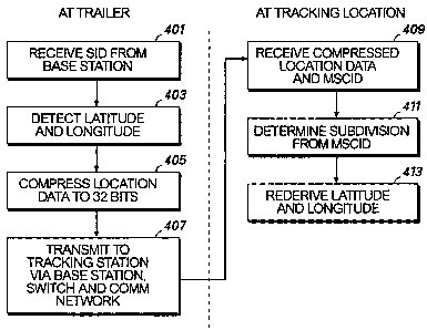
The numbered operational steps are shown in the flew chart of Fig. 4.
Fig. 1 shows a portion 101 of the earth's surface divided by latitude lines
103 and
longitude lines or meridians 105 into subdivisions 107 measuring 9°
latitude by 36°
longitude. A wireless network is deployed in that portion of the earth's
surface. The
wireless network includes one or more cellular towers 109 in its cellular
service area 111.
Thus, each cellular service area 111 correlates to a specific subdivision 107.
A cellular
service area that does not fall wholly within a subdivision 107 is correlated
to that in
which it is dominant. That wireless network can be a public cellular network
or a
proprietary network.
As shown in Fig. 2, a mobile unit 201, such as a trailer, can be equipped with
a
GPS receiver 203 and a wireless communication unit 205, or integration
thereof, that is
compatible with the wireless network. The trailer 201 calls in its location in
the following
manner. The wireless communication unit 205 establishes a communication link
at step
401 through its antenna 206 with the cellular tower 109 of the nearest base
station 207.
That base station 207 and other base stations in the same cellular market are
connected to
a switch 209, which has a previously assigned MSCID and transmits the SID
portion of
the MSCID back through the base station 207 to the wireless communication unit
205.
The GPS receiver 203 determines the location to within a second of latitude
and longitude
at step 403 and communicates the positional data representing the location to
the wireless
communication unit 205.
The positional data are compressed or reduced at step 405 to fit within a data
2~ packet or payload of a predetermined small size, such as 32 bits, and then
transnutted at
step 407 to the base station 207. In the preferred embodiment, as noted above,
the
latitude and longitude are reduced to 15 bits and 17 bits, respectively. That
reduction can
be done in any of several manners. The high-order bits can simply be stripped.
Alternatively, the wireless communication unit 205 can receive the SID from
the base
station 207 and determine the subdivision in which the trailer 201 is located
by inputting
the SID into a lookup table 208. Lookup tables as such are known in the
electronic arts
and can be implemented in any suitable memory. Such a lookup table is feasible
because
ATLLiH02 22922 2
AMENDED SHEET
CA 02349660 2001-05-07
22-11-2000 ~ ~ PCT/US99/25284
Replacement Sheet
of the above-noted correlation of the cellular service areas a~i the
subdivisions. Then,
the latitude and longitude received from the GPS receiver 203 can be converted
into the
latitude and longitude relative to a corner or other predetermined point in
the subdivision.
The base station 207 transmits the reduced data size latitude and longitude
information in a conventional manner via the switch 209 and the network 301 to
a
tracking location 303 shown in Fig. 3. However the latitude and longitude
information
are reduced, the tracking location 303 rederives the full (or absolute)
latitude and
longitude information. One way to do so uses the MSCID, since it is known in
the art, as
has already been explained, for the switch to transmit the MSCTD to the
tracking location.
Thus, when the tracking location 303 receives the data packet containing the
reduced
amount of positional data at step 409, the tracking location 303 also receives
the MSCID.
The tracking location 303 inputs the SID portion of the MSCID, and optionally
also the
switching entity portion, into a lookup table 305 to determine the subdivision
at step 411.
From the subdivision and the transmitted latitude and longitude information,
the full
latitude and longitude, each to within a second, can be rederived using
appropriate
calculating circuitry 307 at step 413.
In short, the latitude and longitude data are sent in a compressed or reduced
format
and are reconstructed using data that are transmitted through the wireless
network
anyway, namely, the MSCID. Thus, the latitude and longitude data are
transmitted more
efficiently than in the prior art.
While a preferred embodiment of the present invention has been set forth in
detail
above, those skilled in the art who have reviewed the present disclosure will
readily
appreciate that other embodiments can be realized within the scope of the
invention. For
example, while the latitude and longitude data have been taught as being
deterniined to
within a second, the invention can be implemented at any resolution allowed by
the GPS
or other technology used to detect the position. Also, while position has been
expressed
in terms of latitude and longitude, the present invention could just as easily
be applied to
positional data in any other form and in one, two, or three dimensions.
Furthermore, while the preferred embodiment has been disclosed for use with
cellular systems conforming to the TIA/EIA 553 standard, the present invention
is equally
applicable to other radiotelephone systems. For example, the cellular network
can be a
proprietary network, in which case the reduction of the latitude and longitude
data can be
ATLLIB02 22922
AMENDED SHEET
CA 02349660 2001-05-07
22-11-2000 ~ ' PCT/US99/25284
. ' 9
Replacement Sheet
performed at the switch. In that case, the wireless communication unit 205
does not need
to know the MSCID. Moreover, while the preferred embodiment allows locations
across
the earth, limited only by the availability of radio telephony equipment, a
smaller
macrocosm, such as a single continent, could be agreed upon and subdivided
instead.
Therefore, the invention should be construed as limited only by the appended
claims.
ATLLIB02 22922 2
AMENDED SHEET