Note : Les descriptions sont présentées dans la langue officielle dans laquelle elles ont été soumises.
CA 02351770 2001-06-27
Atty. Docket No. 4919.00019
METHOD AND APPARATUS FOR
ACTIVATING WEATHER WARNING DEVICES
TECHNICAL FIELD
The present invention relates generally to weather forecasting and warning
systems. More particularly, the invention provides a method and apparatus for
remotely
activating one or more warning devices that may be dispersed across a
geographic area.
BACKGROUND OF THE INVENTION
Tornadoes cause widespread damage each year in the United States. In order to
help minimize loss of life, many municipalities have installed tornado sirens
that are
activated when an approaching tornado is detected. Federal Signal Corporation
of
University Park, Illinois, manufactures various sirens and controllers that
can be activated
when authorities determine that an emergency is imminent. SafetyCom
Incorporated of
Little Rock, Arkansas, similarly provides various sirens to warn residents of
emergencies.
Other systems are exemplified by U.S. patents 4,812,825 ("Tornado Warning
System")
and 6,034,608 ("Tornado Alarm System").
Although tornado sirens allow residents to take shelter in the event of an
impending tornado, the means by which the sirens are activated sometimes
results in
alarming residents who are in no real danger of being affected by a tornado.
Tornado
sirens are often activated on a county-wide basis, thus alarming many
residents who are
far from the projected tornado path, but who happen to be within the county or
predetermined geographic zone that is associated with an impending tornado
risk.
Alternatively, in some communities, emergency operators manually activate
individual
sirens based on a visual comparison of weather displays (or text descriptions
of displays
provided by the National Weather Service) with geographic maps showing the
location of
sirens in the area serviced by the emergency center.
In the latter situation, errors can arise based on the need to visually
compare and
judge distances and features on two different displays. Moreover, where only a
generalized tornado warning is received, employees must use their discretion
in
determining whether to activate a given siren. The time required to translate
a given
I
CA 02351770 2001-06-27
Atty. Docket No. 4919.00019
warning into siren activation signals and the lack of meteorological training
of many
municipal or county employees can result in errors, delays, and false alarms.
Another problem relates to reliance on radio frequency transmission paths to
activate individual sirens. Sirens are typically activated from a central
control unit (e.g., a
county-wide unit) by transmitting radio control signals over police radio
frequencies,
which can sometimes become so crowded or jammed during a weather emergency
that
radio control signals may not be received. It can also be difficult to
determine whether a
given siren has actually been activated after a signal has been sent.
It is expensive for municipalities to pay for employees to monitor and respond
to
tornado threats by activating sirens. For a small county with a few sirens,
the job
function may be shared by an emergency 911 operator or a fire marshal, who
often have
other duties and job responsibilities. Counties or cities often cannot afford
full-time
meteorologists to pinpoint the likely path of a tornado and communicate that
information
to a county emergency center, which must then compare the warning information
to a
map showing the location of various sirens within the county or city. Two
adjacent
counties may have separate, incompatible warning systems that are operated by
different
people and activated on the basis of different information.
The aforementioned problems give rise to the solutions provided by the present
invention.
SUMMARY OF THE INVENTION
The invention provides a system and method for activating warning devices,
such
as tornado sirens, in conjunction with a meteorological map display that shows
the actual
and/or predicted path of a tornado or other meteorological event. In one
variation of the
invention, a user can manually select one or more tornado warning devices by
drawing a
box or other encircling indicator around icons on a computer screen each
representing the
location of a tornado warning device. The selection can be made on a computer
screen
that simultaneously shows both the meteorological event and the location of
each warning
device. In another variation, activation can occur automatically by computer
based on a
comparison of a tornado location with the location of one or more warning
devices.
A central weather prediction center can be remotely coupled to a plurality of
2
CA 02351770 2001-08-21
tornado warning devices in dispersed geographic regions (e.g., different
cities,
counties, or states), thus avoiding the need for persons located in each of
those regions
to be responsible for activating sirens in the particular region. Remote
activation can
occur over telephone lines, packet switched networks, the Internet, frame
relay
networks, and the like.
According to one aspect of the invention, there is provided a computer-
implemented method of activating a warning device, comprising the steps of:
(1) displaying on a computer display device meteorological information
for a particular geographic region and displaying on the same computer display
device
information representing the geographic location of a plurality of warning
devices;
(2) selecting one or more of the plurality of warning devices displayed on
the computer display device; and
(3) remotely activating the one or more warning devices selected in step
(2).
According to another aspect of the invention, there is provided a computer-
implemented method of activating a warning device, comprising the steps of:
(1) at a central location that generates predictions of meteorological
events, detecting a condition that a tornado is likely to strike a given
geographic
location;
(2) at the central location, using a computer to compare the strike location
of the tornado to a plurality of geographically dispersed warning devices-
located in a
geographic region different from the central location and selecting one or
more of the
geographically dispersed warning devices in response to the comparison; and
(3) remotely activating the selected one or more geographically dispersed
warning devices.
According to a further aspect of the invention, there is provided a method of
remotely activating a selected one of a plurality of weather related warning
devices,
comprising the steps of:
(1) identifying the location of a weather phenomenon by visually observing
meteorological conditions near the weather phenomena;
(2) based on the location of the weather phenomenon in step (1), wirelessly
transmitting an activation code, wherein the activation code corresponds to a
specified
one of the plurality of warning devices; and
3
CA 02351770 2007-08-16
(3) in response to the activation code, activating the specified one of the
plurality of warning devices.
In accordance with an aspect of the present invention, there is provided a
computer-implemented method of activating a warning device, comprising the
steps
of.
(1) displaying on a computer display device meteorological information for a
particular geographic region and displaying on the same computer display
device
information representing the geographic location of a plurality of warning
devices;
(2) selecting one or more of the plurality of warning devices displayed on the
computer display device; and
(3) remotely activating the one or more warning devices selected in step (2).
In accordance with another aspect of the present invention, there is provided
a
computer-implemented method of activating a warning device, comprising the
steps
of.
(1) at a central location that generates predictions of meteorological events,
detecting a condition that a tornado is likely to strike a given geographic
location;
(2) at the central location, using a computer to compare the strike location
of
the tornado to a plurality of geographically dispersed warning devices located
in a
geographic region different from the central location and selecting one or
more of the-
geographically dispersed warning devices in response to the comparison; and
(3) remotely activating the selected one or more geographically dispersed
warning devices.
In accordance with another aspect of the present invention, there is provided
a
method of remotely activating a selected one of a plurality of weather-related
warning
devices, comprising the steps of:
(1) identifying a location of a weather phenomenon by identifying the location
of a visual observation near the weather phenomenon;
(2) based on the location of the weather phenomenon in step (1), wirelessly
transmitting an activation code, wherein the activation code corresponds to a
specified
one of the plurality of warning devices; and
(3) in response to receiving the activation code, activating the specified one
of
the plurality of warning devices, wherein step (2) comprises the step of using
an input
device of a handheld computing device to select one of the plurality of
warning
3a
CA 02351770 2007-08-16
devices.
In accordance with another aspect of the present invention, there is provided
a
method of remotely activating a selected one of a plurality of weather-related
warning
devices, comprising the steps of-
(1) identifying the location of a weather phenomenon by visually observing
meteorological conditions near the weather phenomenon;
(2) based on the location of the weather phenomenon in step (1), wirelessly
transmitting an activation code, wherein the activation code corresponds to a
specified
one of the plurality of warning devices; and
(3) in response to receiving the activation code, activating the specified one
of
the plurality of warning devices, wherein the activation code is transmitted
to a device
activator, and wherein the device activator performs step (3).
In accordance with another aspect of the present invention, there is provided
a
method of remotely activating a selected one of a plurality of weather-related
warning
devices, comprising the steps of:
(1) identifying the location of a weather phenomenon by visually observed
meteorological conditions near the weather phenomenon;
(2) based on the location of the weather phenomenon in step (1), wirelessly
transmitting an activation code, wherein the activation code corresponds to a
specified
one of the plurality of warning devices; and
(3) in response to receiving the activation code, activating the specified one
of
the plurality of warning devices, wherein step (2) is performed using a
cellular
telephone.
In accordance with another aspect of the present invention, there is provided
a
system for remotely activating one or more of a plurality of weather warning
devices
that are dispersed across a geographic region, comprising a computer that
receives
and displays on a computer display device meteorological information relating
to a
weather threat in a portion of the geographic region and information
representing the
location of the plurality of weather warning devices in the portion of the
geographic
region, wherein the computer includes an input device and associated software
that
allows a user to visually compare the weather threat to the location of the
plurality of
weather warning devices and to select one or more of the weather warning
devices in
response to the visual comparison, and wherein the computer generates an
activation
3b
CA 02351770 2007-08-16
signal that transmits a code to activate the selected one or more of the
weather
warning devices in response to the user selection.
BRIT F DESCRIPTION OF THE DRAWINGS
FIG. 1 shows a conventional approach for activating individual warning
devices in a given geographic region by using a centralized siren activator
101.
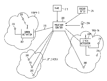
FIG. 2A shows a system and method for activating one or more warning
devices in one or more geographically dispersed areas according to one
variation of
the invention.
FIG. 2B shows a system and method for activating one or more warning
devices remotely through the use of cellular telephones or other wireless
devices
according to another variation of the invention.
FIG. 2C shows a system and method for selecting one or more warning
devices based on a meteorological display that shows the location of warning
devices
according to another variation of the invention.
FIG. 3 shows one possible computer display and selection-method for
selecting a group of warning devices 309 and activating sirens in the selected
group.
FIG. 4 shows steps for selecting and activating warning devices on the basis
of
meteorological data that is displayed on a computer screen.
DETAILED DESCRIPTION OF THE INVENTION
FIG. 1 shows a conventional approach for activating warning devices, such as
tornado warning sirens. A municipality (e.g., Memphis) typically has a
centralized
siren activation unit 101 that is couple to a plurality of warning devices 102
through
104. The activation unit 101 may be located in the basement of a municipal
facility
(e.g., a police station or emergency dispatch center). The activation unit can
selectively activate one or more warning devices by transmitting a radio
frequency
signal over an available channel, such as a shared police band. Activation is
performed by a human, who receives information suggesting that a tornado 105
is
headed for the county. Such information
3c
CA 02351770 2001-06-27
Atty. Docket No. 4919.00019
may be provided by the National Weather Service, which issues warnings on a
regional
(e.g., county) basis, sometimes including a projected path 106.
FIG. 2A shows a system and method for activating warning devices in one or
more geographically dispersed areas according to one variation of the
invention. As
shown in FIG. 2A, three different geographically dispersed areas (Memphis,
Little Rock,
and Wichita) each include a plurality of warning devices of the type
exemplified by those
manufactured by Federal Signal Corporation or SafetyCom Inc. Although it is
preferred
that each device be activated over a land line (e.g., a land-based direct line
or frame relay
line) rather than a radio frequency channel in order to provide better
assurance of
communication quality, the invention is not limited in this respect.
If telephone activation is used, it may be necessary to modify or supplement
each
device with a telephone receiving control unit that responds to a telephone
call and,
through a DTMF sequence, receives a code that activates the device and
provides
confirmation that the device has been activated. For example, each warning
device can be
assigned to a distinct telephone number that rings to an automated call pick-
up unit. The
automated pick-up unit answers the line, responds to a known activation code
(which may
include several digits as a security precaution) and, in response to detecting
the correct
activation code, activates the warning device and transmits an acknowledgement
signal
over the telephone line. In one variation, each unit can be activated by a
human (e.g., by
a cellular or conventional telephone dial-in procedure). In another variation,
each unit
can be activated by a computer-controlled siren activator 207 or via long-
distance
telephone lines 212 (including, for example, frame relay lines) from a weather
center 200.
Alternatively, a conventional siren activator can be used to activate one or
more warning
devices, but the activator is instructed as to which warning devices(s) to
activate from a
remote weather center 200.
As shown in FIG. 2A, two warning devices 201 and 202 are activated from a
siren
activator 207 that receives computer instructions via communication lines 212
from a
weather center 200. Weather center 200 receives meteorological data in the
form of radar
images from various radar sites 211 and other information such as reports
indicating the
current latitude and longitude of a tornado. Additionally, weather reports can
be received
4
CA 02351770 2001-06-27
Atty. Docket No. 4919.00019
from one or more "spotters" 214 who actually see a tornado or tornado-like
conditions.
In the latter case, each spotter can provide the latitude and longitude
coordinates of the
tornado, or such information can be provided automatically using a GPS-
equipped device
and transmitted to weather center 200.
Weather center 200 monitors weather conditions around various geographic areas
such as Memphis, Wichita, and Little Rock, and optionally predicts a future
path of
tornados that are detected near any of these areas using conventional
meterological
techniques. Weather center 200 also maintains information regarding the
positional
location (e.g., latitude and longitude) of each warning device in each
geographic area. In
response to detecting that a tornado is actually or predicted to be near one
or more of the
warning devices, weather center 200 transmits activation signals over the
communication
lines to the appropriate siren activator and/or warning devices. In one
embodiment, upon
detecting that a weather event (e.g., a tornado) is actually or predicted to
be a
predetermined or user-selectable distance from a warning device, the warning
device is
activated.
The detection and activation can occur automatically by computer (e.g., all
warning devices that are determined to be within a given radius of a current
or predicted
tornado path), or it can be done manually through the use of trained
meteorologists who
render judgments based on their experience. In. any event, as shown in FIG.
2A, a
plurality of different geographically dispersed localities can receive tornado
activation
service from a central weather center 200, and thus need not employ personnel
to monitor
and activate the warning devices in each jurisdiction. In a preferred
embodiment, each
warning device and/or siren activator responds to an activation signal with a
confirmatory
signal confirming that activation has occurred. The confirmed activation can
then be
displayed on a computer display at weather center 200 or at other computer
locations.
In one embodiment, activation information and meteorological information is
transmitted over telephone lines or the Internet to municipal authorities in
each
jurisdiction to provide confirmation that action has been taken in response to
a tornado
threat. The combination of meteorological expertise and prediction facilities
at weather
5
CA 02351770 2001-06-27
Atty. Docket No. 4919.00019
center 200 with remote activation capabilities provides improved service at
reduced cost
to the municipalities.
Tornado warnings from the National Weather Service (in the form of county-wide
warnings and/or specific LAT/LON information) can be used in weather center
200 to
activate regional warning devices in different geographically dispersed
regions. For
example, if the NWS issues a tornado warning for Memphis and one for Wichita,
weather
center 200 can automatically transmit an activation code to activate all
warning devices in
those municipalities, without requiring intervention by a human operator in
those
municipalities. Alternatively, if specific LAT/LON information is received
from the
NWS, weather center 200 can activate specific warning devices in separate
municipalities
based on the information, again without requiring employees in each
jurisdiction to
monitor and/or activate sirens.
FIG. 2B shows a system and method for activating one or more warning devices
remotely through the use of cellular telephones or other wireless devices
according to
another variation of the invention. As shown in FIG. 2B, a siren activator 214
is coupled
to a plurality of warning devices 215 through 217 through telephone lines.
Siren
activator 214 may comprise a modified version of a device manufactured by one
of the
aforementioned companies that is configured to receive codes via telephones
(including
cellular telephones) indicating which warning device(s) should be activated.
According
to this embodiment, spotters 218 and 223 visually observe a tornado 221 and
place a
telephone call to a predetermined telephone number, which responds with an
automated
message to enter an activation code corresponding to one or more sirens.
Alternatively,
each spotter can enter his or her latitude and longitude corresponding to the
observed or
estimated location of the tornado, and siren activator 214 activates all
warning devices
that are within a certain range of the tornado location.
In yet another variation, spotters may use a wireless device equipped with a
GPS
receiver, which automatically transmits the spotter's current location at the
push of a
button. For example, a wireless hand-held computing device such as a Palm
PilotTM VII
manufactured by the Palm Corporation can be used to transmit the user's
current location
to a wireless address, telephone number (e.g., through a cellular telephone
antenna 220),
6
CA 02351770 2001-06-27
Atty. Docket No. 4919.00019
or Internet address along with an activation code and/or security code. In one
embodiment, the hand-held unit displays a map showing the user's current
location, and
has superimposed thereon the location of one or more warning devices located
in the
geographic vicinity of the displayed map. Using a stylus or other input
device, the spotter
can activate a warning device by selecting it on the display and entering a
security code or
other information to cause a signal to be transmitted to the indicated warning
device.
Alternatively, the spotter can transmit a current location (e.g., as obtained
by GPS) to a
central device activator, which then selects one or more warning devices that
are in the
proximity of the current location of the spotter.
Such devices can also be used in the system of FIG. 2A in order to transmit
spotter information to weather center 200. While the remote activation scheme
is
illustrated as relying on a central siren activator 214, it will be
appreciated that each
spotter can directly contact and activate warning devices if each device is
coupled to a
telephone line or computer device capable of receiving an activation code.
FIG. 2C shows yet another variation of the invention, wherein an activation
center
224 includes a computer with display 228 and a siren activator 229. The
computer 228
receives meteorological information in the form of current and/or predicted
tornado
positions from external sources, such as weather center 231 and/or the
National Weather
Service 232, and superimposes that information on a computer map showing the
location
of each of a plurality of warning devices 225 through 227. A human user
visually
observes the actual and/or predicted path of the tornado on the display of
computer 228
and, through the use of a keyboard, trackball, mouse, or other input device,
graphically
selects one or more warning devices that are in the path of the tornado.
Activation can occur over the Internet, through telephone dial-up lines,
cellular
telephone channels, and the like. The meteorological data and warning device
locational
data may be displayed using web pages and a web browser. In one embodiment,
hyperlinks associated with each warning device can be selected by a user in
order to
activate the warning device.
In addition to traditional warning devices such as sirens, the activation
signal can
be fed to cable television distribution facilities that service particular
geographic areas,
7
CA 02351770 2001-06-27
Atty. Docket No. 4919.00019
such that a warning can be displayed on televisions associated with a
particular
geographic area (e.g.., specific neighborhoods or houses). Additionally,
activation signals
can be transmitted to web sites and other computer systems for further use
such as display
purposes (e.g., display on web pages, wireless devices, cellular telephones,
and the like).
In one variation of the invention, computer 228 automatically calculates which
of
the warning devices are within a predetermined distance from the predicted
tornado path
and suggests activation to the user. The selection can be temporally based,
such that as
new information becomes available (e.g., the tornado changes course), certain
warning
devices are automatically de-activated while others are activated.
FIG. 3 shows one possible computer display and selection method for selecting
a
group of warning devices 309 and activating sirens in the selected group. The
computer
display 300 can be used in the weather center 200 of FIG. 2A to remotely
activate one or
more warning devices located in geographically disparate regions, or in a
regional
activation center 224 of the type shown in FIG. 2C.
As shown in FIG. 3, the computer display 300 has superimposed thereon a
geographic map showing the location of a plurality of warning devices 301
through 308.
The warning devices may span one or more counties, cities, or other municipal
regions.
A tornado 311 and/or other meteorological data is superimposed on the map in
such a
way that the location of the tornado relative to the warning devices can be
visually
observed. Additionally, a predicted path 312 of the tornado, such as a
computer-
generated prediction or simulation, can also be superimposed on the display in
such a way
that the future path of the tornado relative to the warning devices can be
visually
discerned.
A user of the computer system shown in FIG. 3 uses a cursor 310 and one or
more
control elements 313 and 314 to draw a box 309 around a subset of the warning
devices
(306, 307, and 308) that are visually determined to be in the path of the
oncoming
tornado. After selecting a group of warning devices in this fashion, the user
can activate
the warning devices using an activation button 314. In one embodiment, the
user is
prompted to enter a password or other authenticating information to prevent
the
accidental or false activation of warning devices. After selecting and
activating the
8
CA 02351770 2001-06-27
Atty. Docket No. 4919.00019
warning devices, the computer transmits codes to the selected warning devices
and, upon
receiving confirmation from the warning devices that they have been activated,
displays
them in a different color on the computer display to confirm that they have
been correctly
activated.
As explained above, in one variation of the invention, the computer
automatically
identifies those warning devices that are within a predetermined or user-
selected distance
from the current and/or predicted path of the tornado (e.g., during a time
period spanning
30 minutes). After the computer selects the warning devices, the user is
prompted to
confirm activation of the computer-selected warning devices. It is a
straightforward task
to program a computer with software to compare the geographic location of each
of a
plurality of warning devices to an actual or predicted path of a tornado, and
no further
elaboration is required.
In one variation, the computer can automatically activate the warning devices
without user intervention by comparing tornado location information to warning
device
locations and activating those warning devices that are within a predetermined
range of
the tornado location or its predicted path. The activation can also occur in a
staggered
time sequence, such that warning devices are automatically activated and
deactivated as
the tornado approaches different areas serviced by the warning devices.
FIG. 4 shows steps for selecting and activating warning devices on the basis
of
meteorological data that is displayed on a computer screen. The method of FIG.
4 can be
practiced at a central weather center such as center 200 of FIG. 2A, or at a
regional
control center such as center 224 of FIG. 2C.
Beginning in step 401, a computer generates a display of meteorological data
on a
map. The data can include radar reflectivity data such as that generated by
NEXRAD
radars operated by the National Weather Service; "slime track" information
showing the
position of observed or actual tornados over a period of time; meteorologist-
entered
information such as the suspected location of a tornado or other severe
weather event;
information derived from spotters; and other data tending to show a severe
weather event
such as a tornado. In one embodiment, this information can also include
predicted future
storm or tornado tracks that are predicted using any of various technologies,
such as those
9
CA 02351770 2001-06-27
Atty. Docket No. 4919.00019
illustrated in U.S. Patent No. 5,959,567, entitled "Method and Apparatus for
Tracking of
Organized Storms."
The future path of a tornado or other severe weather event can be predicted in
various ways. As noted above, a future storm path can be predicted using an
algorithm of
the type described in the '567 patent. In another embodiment, a future path
can be
predicted using human judgment (e.g., trained meteorologists monitoring
various radar
data and other sensed information). In yet another embodiment, a projected
path as
provided by the National Weather Service (NWS) can be used. The NWS often
provides
an array of points or "dots" that can be connected to determine the path along
which a
tornado or hurricane is expected to move. The swath cut by the projected path
may
intersect the range of one or more warning devices, which can then be
automatically
activated by computer.
A tornado location can be heuristically determined using a combination of
radar
echo shape ("hook" echo), radar wind velocity and echo structure, all well
known in the
meteorological community. Once the initial position is determined, a predicted
future
location can be predicted using the principles set forth in the '567 patent,
or a
meteorologist can use his or her judgment to establish a projected future
path. The
National Weather Service transmits a Tornado Detection Algorithm (TDA) in its
WSR-
88 radar data stream, and this TDA position could thus also be used. The NWS
also uses
its own movement algorithms, which could be employed in conjunction with the
principles of the invention. Finally, information supplied by "spotters" can
be used in
conjunction with any of the above techniques in order to pinpoint the location
of an actual
tornado.
In step 402, the locations of warning devices such as tornado sirens is also
displayed on the same map as the meteorological data. This allows a user to
visually
compare the location of the meteorological event with the location of the
warning
devices. This step can be optional, particularly if the computer automatically
selects
warning devices on the basis of meteorological data.
In step 403, specific warning devices are selected based on the meteorological
data. As shown in FIG. 3, for example, a human can select a group of one or
more
CA 02351770 2001-06-27
Atty. Docket No. 4919.00019
warning devices that are in the path of an impending or predicted tornado.
Alternatively,
the computer can automatically select and activate specific warning devices on
the basis
of the actual or predicted path of the tornado or other event.
In step 404, the selected warning devices are activated, either by a human
user or
by computer. The activation can occur over telephone land-lines, frame relay
networks,
the Internet, or by other means.
Finally, in step 405 the activated devices provide confirmation that they have
been
activated, and their activated state is optionally displayed on the computer
display to
provide visual assurance that activation has occurred.
It will be appreciated that the warning device can be any type of device
capable of
issuing a warning in conjunction with a severe weather event, such as a
tornado,
hurricane, lightning, wind shear, or the like. The warning device can be
associated with
or service a geographic region, a corporate facility, an airport, factory, or
any other entity
or geographic area. Warnings can be issued in the form of sound, visual, radio
frequency,
television, telephonic, and the like.
In one embodiment, a computer automatically calls residents having telephone
numbers corresponding to an area for which a severe weather event is occurring
or
projected to occur, and plays a recorded message indicating the nature of the
threat. In
such an embodiment, the warning device itself need not be located in the area
of the
threat; instead, the warning is communicated to persons located in the
affected area by a
computer that is potentially located outside the affected area. Databases
containing
telephone numbers and street addresses corresponding to the numbers can be
searched
automatically by computer once the geographic area subject to threat (e.g.,
including
streets, zip codes, or the like) is known. This technique is analogous to the
"reverse 911"
automated calling process used by police departments to transmit information
concerning
recent crimes in a given neighborhood.
What has been described above is merely illustrative of the application of the
principles of the present invention. Other arrangements and methods can be
implemented
by those skilled in the art without departing from the spirit and scope of the
present
invention. Any of the methods of the invention can be implemented in software
that can
11
CA 02351770 2001-06-27
Atty. Docket No. 4919.00019
be stored on computer disks or other computer-readable media for execution in
a host or
target computer. The invention can be implemented using web browser
technology,
handheld computing units, arid/or cellular telephones. Moreover, while the
illustrative
example of tornado warnings has been used in the description, the invention is
applicable
to other types of weather warnings such as lightning, hail, hurricanes, wind
shear, and the
like, and the inventive principles can be applied equivalently to such
phenomena. No
claim should be interpreted to be in means plus function format. Numbered
steps in
method claims should not be interpreted to require a particular ordering of
the steps.
12