Sélection de la langue

Search

Sommaire du brevet 2372843 

Énoncé de désistement de responsabilité concernant l'information provenant de tiers

Une partie des informations de ce site Web a été fournie par des sources externes. Le gouvernement du Canada n'assume aucune responsabilité concernant la précision, l'actualité ou la fiabilité des informations fournies par les sources externes. Les utilisateurs qui désirent employer cette information devraient consulter directement la source des informations. Le contenu fourni par les sources externes n'est pas assujetti aux exigences sur les langues officielles, la protection des renseignements personnels et l'accessibilité.

Disponibilité de l'Abrégé et des Revendications

L'apparition de différences dans le texte et l'image des Revendications et de l'Abrégé dépend du moment auquel le document est publié. Les textes des Revendications et de l'Abrégé sont affichés :

  • lorsque la demande peut être examinée par le public;
  • lorsque le brevet est émis (délivrance).
(12) Brevet: (11) CA 2372843
(54) Titre français: AMELIORATIONS DANS OU RELATIVES A LA LOCALISATION D'OBJET
(54) Titre anglais: IMPROVEMENTS IN OR RELATING TO OBJECT LOCATION
Statut: Périmé et au-delà du délai pour l’annulation
Données bibliographiques
(51) Classification internationale des brevets (CIB):
  • G01S 05/00 (2006.01)
  • G01S 05/06 (2006.01)
  • G01S 13/74 (2006.01)
(72) Inventeurs :
  • RICKARD, DAVID CHARLES (Royaume-Uni)
  • HORNE, JAMES WILLIAM (Royaume-Uni)
(73) Titulaires :
  • ROKE MANOR RESEARCH LIMITED
(71) Demandeurs :
  • ROKE MANOR RESEARCH LIMITED (Royaume-Uni)
(74) Agent: BORDEN LADNER GERVAIS LLP
(74) Co-agent:
(45) Délivré: 2005-04-12
(86) Date de dépôt PCT: 2000-05-11
(87) Mise à la disponibilité du public: 2000-11-23
Requête d'examen: 2003-12-02
Licence disponible: S.O.
Cédé au domaine public: S.O.
(25) Langue des documents déposés: Anglais

Traité de coopération en matière de brevets (PCT): Oui
(86) Numéro de la demande PCT: PCT/GB2000/001801
(87) Numéro de publication internationale PCT: GB2000001801
(85) Entrée nationale: 2001-11-07

(30) Données de priorité de la demande:
Numéro de la demande Pays / territoire Date
9911135.3 (Royaume-Uni) 1999-05-14

Abrégés

Abrégé français

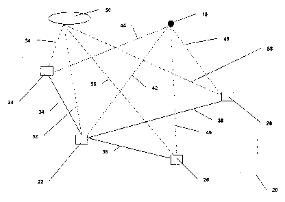
L'invention concerne un système de localisation d'objet permettant de localiser un objet (10) qui produit des signaux d'identification. Le système comprend une pluralité de sites récepteurs (22, 24, 26, 28) disposés dans une matrice (20) pour recevoir des signaux de l'objet (10) et pour recevoir une référence de temps commune sous la forme de signaux reçus par l'intermédiaire d'un système à navigation globale (50). La matrice (20) comprend un site récepteur de référence (22) et trois sites récepteurs auxiliaires (24, 26, 28), les sites auxiliaires étant connectés au site de référence par des liaisons de données(34, 36, 38). Chaque site récepteur (22, 24, 26, 28) reçoit des signaux (42, 44, 46, 48) de l'objet (10) et des signaux de synchronisation (52, 54, 56, 58) du système à navigation globale (50). Chaque site détermine une différence entre les temps de réception des signaux de l'objet et les signaux de synchronisation. Les sites auxiliaires (24, 26, 28) offrent des signaux de données sur des liaisons de données (34, 36, 38) du site de référence (22) à l'endroit où l'objet (10) est déterminé.


Abrégé anglais


Described herein is an object located system for locating an object (10) which
produces identifying signals. The system comprises a
plurality of receivers sites (22, 24, 26, 28) arranged in an array (20) for
receiving signals from the object (10) and for receiving a common
time reference in the form signals received from a global navigation system
(50). The array (20) comprises a reference receiver site (22)
and three auxiliary receiver sites (24, 26, 28), the auxiliary sites being
connected to the reference site by data links (34, 36, 38). Each
receiver site (22, 24, 26, 28) receives signals (42, 44, 46, 48) from the
object (10) and timing control signals (52, 54, 56, 58) from a
global navigation system (50). Each site determines a time difference between
the receipt of the object signals and the timing signals, the
auxiliary sites (24, 26, 28) providing data signals on data links (34, 36, 38)
to the reference site (22) where the location of the object (10)
is determined.

Revendications

Note : Les revendications sont présentées dans la langue officielle dans laquelle elles ont été soumises.


-9-
CLAIMS:
1. A method of locating the position of an object which provides identifying
signals
using a receiver array comprising a reference receiver site and at least three
auxiliary receiver
sites, the method comprising the steps of:
receiving the identifying signals from the object at each receiver site;
receiving signals from a global navigation system at each receiver site and
using the
received signals for providing timing signals;
providing a clock at each receiver site for providing clock signals;
combining the timing signals with the clock signals to provide a timing
reference
signal at each receiver site;
determining the time difference between receiving the identifying signals and
the
timing reference signal at each receiver site;
transmitting data signals to the reference receiver site which are indicative
of the
determined time differences at each auxiliary receiver site; and
calculating the position of the object using the transmitted data signals and
the time
difference determined at the reference receiver site.
2. A method according to claim 1 wherein the auxiliary receiver sites are not
on a line of
sight with the reference receiver site.
3. Apparatus for locating an object producing identifying signals, the
apparatus
comprising:
a receiver array comprising a reference receiver site and at least three
auxiliary
receiver sites;
first receiver means at each receiver site for receiving the identifying
signals from the
object;
second receiver means at each receiver site for receiving timing signals from
a global
navigation system;

-10-
clock means at each receiver site for generating clock signals;
combining means at each receiver site for combining the timing signals and
clock
signals to provide a timing reference signal;
processing means at each receiver site for receiving signals from the first
receiver
means and the combining means and for providing a time difference measurement
from the
received signals; and
control means at the reference receiver site for receiving data signals from
the
auxiliary receiver sites indicative of the time different measurement signals
determined
thereat, and for processing the data signals together with the time difference
measurement
from the reference receiver site to provide a determination of the location of
the object.
4. Apparatus according to claim 3, wherein the identifying signals from the
object
comprise secondary surveillance radar (SSR) signals and the first receiver
means comprises a
SSR receiver.
5. Apparatus according to claim 3 or 4, wherein the clock means comprises a
high
precision clock oscillator.
6. Apparatus according to claim 3 or 4, wherein the processing means
comprises, a time
interval counter and a measurement control system.
7. Apparatus according to any one of claims 3 to 6, wherein the processing
means
includes a communications interface for interfacing between each auxiliary
receiver site and
the reference receiver site.
8. Apparatus according to any one of claims 2 to 6, wherein the auxiliary
receiver sites
are not on a line of sight with the reference receiver site.

Description

Note : Les descriptions sont présentées dans la langue officielle dans laquelle elles ont été soumises.


CA 02372843 2001-11-07
WO 00/70363 PCT/GB00/01801
-1-
IMPROVEMENTS IN OR RELATING TO OBJECT LOCATION
The present invention relates to improvements in or relating to object
location.
There are several techniques which can be utilised to locate the
position of an object relative to a reference point, for example, the position
of
an aircraft with respect to one of a plurality of sites. One such technique is
described in GB-B-2 250 154.
In GB-B-2 250 154, an object location system is described in which a
master or reference receiver and a plurality of auxiliary receivers are
precisely located with respect to one another for receiving signals from an
object. The signals received at the receivers from the object comprise
secondary surveillance radar (SSR) generated by the object. Each auxiliary
receiver is synchronised with respect to a signal sent from the reference
receiver so that a computation device associated with the reference receiver
can determine the precise location of the object from signals received at all
the receivers. In this system, the reference receiver and at least three other
auxiliary receivers are required to generate four simultaneous equations
which are solved by the computation device to provide the position of the
object in three dimensions and the distance the object is from the reference
receiver.
SSR is also used to effect synchronisation between the reference
receiver site and the auxiliary receiver sites. Each auxiliary receiver site
utilises an atomic clock for driving a free running counter which is read on
reception of an SSR signal transmitted thereto from the reference receiver
site. However, in the object location system described in GB-B-2 250 154, it
is necessary for each auxiliary receiver site to have a direct 'line of sight'

CA 02372843 2004-11-05
-2-
with the master or reference receiver site so that the timing signals can be
received.
Another technique for providing synchronisation between the reference receiver
and
the auxiliary receivers disclosed in GB-B-2 250 154 utilises the global
positioning system
(GPS), GPS being used at each receiver site to provide both accurate location
and intersite
clock synchronization.
It is therefore an object of the present invention to provide an object
location system
which does not have the disadvantages mentioned above.
In accordance with one aspect of the present invention, there is provided a
method of
locating the position of an object which provides identifying signals using a
receiver array
comprising a reference receiver site and at least three auxiliary receiver
sites, the method
comprising the steps of:
receiving the identifying signals from the object at each receiver site;
receiving signals from a global navigation system at each receiver site and
using the
received signals for providing timing signals;
providing a clock at each receiver site for providing clock signals;
combining the timing signals with the clock signals to provide a timing
reference
signal at each receiver site;
determining the time difference between receiving the identifying signals and
the
timing reference signal at each receiver site;
transmitting data signals to the reference receiver site which are indicative
of the
determined time differences at each auxiliary receiver site; and
calculating the position of the object using the transmitted data signals and
the time
difference determined at the reference receiver site.
In a preferred embodiment the auxiliary receiver sites are not on a line of
sight with
the reference receiver site. By the term 'line of sight' is meant a direct
line between the two
points without the presence of any obstacles.
In accordance with another aspect of the present invention, there is provided
apparatus
for locating an object producing identifying signals, the apparatus
comprising:

CA 02372843 2004-11-05
-3-
a receiver array comprising a reference receiver site and at least three
auxiliary
receiver sites;
first receiver means at each receiver site for receiving the identifying
signals from the
obj ect;
second receiver means at each receiver site for receiving timing signals from
a global
navigation system;
clock means at each receiver site for generating clock signals;
combining means at each receiver site for combining the timing signals and
clock
signals to provide a timing reference signal;
processing means at each receiver site for receiving signals from the first
receiver
means and the combining means and for providing a time difference measurement
from the
received signals; and
control means at the reference receiver site for receiving data signals from
the
auxiliary receiver sites indicative of the time difference measurement signals
determined
thereat, and for processing the data signals together with the time difference
measurement
from the reference receiver site to provide a determination of the location of
the object.
For a better understanding of the present invention, reference will now be
made, by
way of example only, to the accompanying drawings in which:
Figure 1 illustrates a schematic diagram of an object location system in
accordance
with the present invention; and
Figure 2 illustrates a block diagram of a receiver site in the object location
system of
Figure 1.

CA 02372843 2001-11-07
WO 00/70363 PCT/GB00/01801
-4-
Although the present invention will be described with reference to
height location of an aircraft, it will readily be appreciated that the
invention
can be utilised to determine the location of any object which produces an
identifying signal.
Moreover, it will be appreciated that although the present invention
will be described using the global positioning system (GPS), any global
navigation system and augmentations, for example, global navigation satellite
systems (GNSS), can be implemented.
In Figure 1, an object location system in accordance with the present
invention is shown schematically. The position of an object 10, for example,
an aircraft, is to be determined using a receiver array 20 indicated by dotted
lines. Although the receiver array is shown having a rectangular
configuration, this is not essential to the invention and the receiver array
may
comprise any suitable configuration. An optimum receiver geometry may be
determined for aircraft concentrated within a specified volume of space. The
optimum geometry corresponds to the combination of minimum height
vector, defining the relationship between time measurement error and object
positional error.
The aircraft 10 includes a secondary surveillance radar (SSR) system
which can be interrogated by a signal from the ground, namely, from a
separate interrogator (not shown) or from one of the receiver sites 22, 24,
26,
28 in the array 20 to produce an identifying signal for the aircraft 10.
Alternatively, the SSR can transmit an identifying signal as a series of
pulses.
It will be appreciated that the present invention only requires that the
aircraft
provide some form of identifying signal and the form of the signal is
immaterial.
The receiver array 20 comprises four receiver sites 22, 24, 26, 28.
This is the minimum number of receiver sites which are required to determine

CA 02372843 2001-11-07
WO 00/70363 PCT/GB00/01801
-5-
the location of an aircraft. It may be necessary to use more than four
receiver
sites to maintain adequate coverage and positional accuracy over an extended
volume of space. In the array 20, receiver site 22 is designated as a
reference
receiver site and the other receiver sites 24, 26, 28 as auxiliary receiver
sites,
but it is to be noted that any of the receiver sites could be designated as a
reference receiver site.
Moreover, it is to be noted that in accordance with the present
invention, there is no requirement for a 'line of sight' between the reference
receiver site 22 and the auxiliary receiver sites 24, 26, 28 as timing signals
are obtained by other means as is described in detail below.
Reference receiver site 22 is connected to the auxiliary receiver sites
24, 26, 28 by respective data links 34, 36, 38 as shown. The data links 34,
36, 38 transfer data between the reference site and the auxiliary sites as
will
be described in more detail later.
Each receiver site 22, 24, 26, 28 in the array 20 receives the signal
from the aircraft 10 as illustrated by dotted lines 42, 44, 46, 48
respectively.
It will be appreciated that the time it takes for the signal to reach each
receiver site 22, 24, 26, 28 is different due to the differences in location
of
each site. Each receiver site 22, 24, 26, 28 also receives a global
positioning
system (GPS) signal from a GPS satellite 50 as indicated by chain lines 52,
54, 56, 58 respectively. The GPS signal is used as a timing signal at each
receiver site.
Referring now also to Figure 2, a receiver site 100 is shown in the
form of a block diagram. Any one of receiver sites 22, 24, 26, 28 shown in
Figure 1 may comprise receiver site 100. At receiver site 100, there is
provided a communications interface 110 for providing a data link 120 with
each of the auxiliary receiver sites 24, 26, 28, if the receiver site is the
reference site 22, or with the reference receiver site 22 if the receiver site
is

CA 02372843 2001-11-07
WO 00/70363 PCT/GB00/01801
-6-
an auxiliary receiver site 24, 26, 28. For simplicity, the receiver site 100
will
be described as being an auxiliary receiver site.
The receiver site 100 also comprises a GPS receiver 130 having an
antenna 140, a clock 150, a combining unit 160, a timing interval counter
170, a measurement control system 180, and a SSR receiver 190 having an
antenna 200.
The communications interface 110 is connected to receive control
signals from the reference receiver site 22 along the data link 120 and also
to
transmit data to the reference receiver site 22. The communications interface
110 is connected to the GPS receiver 130 via a link 210, to the SSR receiver
190 via link 230, and also to the measurement control system 180 via a link
220. Link 210 comprises a uni-directional link and operates to transmit an
enable signal for the GPS receiver 130 from the reference receiver site 22.
Link 220 comprises a bi-directional link which connects the measurement
control system 180 to the communications interface 110 and allows for data
transfer between the measurement control system 180 and communications
interface. The link 220 also serves to provide an enable signal for the
measurement control system 180 as will be described in more detail below.
Link 120 comprises a bi-directional link for both receiving data from and
transmitting data to the reference receiver site 22.
As shown in Figure 2, a connection 230 is also provided between the
communications interface 110 and the SSR receiver 190 for providing an
enable signal for the receiver 190.
GPS receiver 130 and clock 150 are both connected to the combining
unit 160 by means of respective connections 240, 250. The output from the
combining unit 160 is connected to the timing interval counter 170 via
connection 260 and to the measurement control system 180 via connection

CA 02372843 2001-11-07
WO 00/70363 PCT/GB00/01801
_7_
270. The timing interval counter 170 is also connected to the measurement
control system 180 via a connection 280.
The operation of the object location system in accordance with the
present invention will now be described in more detail.
The reference receiver site 22 transmits a signal along data links 34,
36, 38 to each of the auxiliary receiver sites 24, 26, 28 which effectively
instructs each auxiliary receiver site to initiate measurement of the time for
the SSR signal from the aircraft 10 to reach that receiver site. The signal on
each data link 34, 36, 38 enters each auxiliary receiver site 24, 26, 28 on
data
link 120 via the communications interface 110. An enable signal is passed
onto the GPS receiver 130 via link 210 and onto the SSR receiver 190 via
link 230 and onto measurement control system 180 via link 220. The GPS
receiver 130, once enabled, receives a signal from a GPS satellite (not
shown) via its antenna 140 and supplies a timing signal to the combining unit
160 via connection 240. Clock 150, which comprises a high precision clock
oscillator, provides clock signals to the combining unit 160 via connection
250.
In the combining unit 160, the timing signals received from the GPS
receiver 130 and the clock signals from the clock 150 are combined to
provide a precise clock reference signal. This clock reference signal is
supplied to the time interval counter 170 and to the measurement control
system 180 via respective connections 260 and 270 respectively. The clock
reference signal on connection 260 provides trigger pulses to the time
interval counter 170 which operates to generate a count indicative of the time
from initiation and supplies it to the measurement control system 180 on
connection 280. The measurement control system 150 also receives the clock
reference signal as trigger pulses on connection 270 from the combining unit
160.

CA 02372843 2001-11-07
WO 00/70363 PCT/GB00/01801
_$_
When a signal is received by the SSR receiver 190 via its antenna 200
from the aircraft 10, the measurement control system 180 receives a signal on
connection 290 from the SSR receiver 190 and the time currently on the time
interval counter 170 is stored in the measurement control system 180. The
measurement control system 180 determines a time difference measurement
between the signals received from the SSR receiver 190 on connection 290
and those received from the time interval counter 170 on connection 280.
The time difference measurement determined by the measurement control
system 180 is then passed to the communications interface 110 via link 220
for transmission to the reference receiver site 22 via link 120.
The combining unit 160 operates to provide the clock reference signal
which counteracts any frequency drift in the clock 150 thereby providing
long term stability.
At the reference receiver site 22, data signals from each of the
auxiliary receiver sites 24, 26, 28 relating to the time difference
measurements between the timing reference signal and the SSR signal
received at each auxiliary receiver site are received. The measurement
control system 180 of the reference receiver site 22 then processes the data
signals from auxiliary receiver sites 24, 26, 28 and the time difference
measurement obtained at the reference receiver site itself to provide an
indication of the location of the aircraft 10 relative to the reference
receiver
site 22.
As the method of the present invention utilises GPS to establish an
accurate reference timing, there is no requirement for there to be a 'line of
sight' between the receiver sites in the receiver array. The receiver sites
may
be chosen to correspond to existing air traffic control centres. Each receiver
may also comprise a mobile installation which facilitates re-configuration of
the receiver array in accordance with changes in aircraft routing.

Dessin représentatif
Une figure unique qui représente un dessin illustrant l'invention.
États administratifs

2024-08-01 : Dans le cadre de la transition vers les Brevets de nouvelle génération (BNG), la base de données sur les brevets canadiens (BDBC) contient désormais un Historique d'événement plus détaillé, qui reproduit le Journal des événements de notre nouvelle solution interne.

Veuillez noter que les événements débutant par « Inactive : » se réfèrent à des événements qui ne sont plus utilisés dans notre nouvelle solution interne.

Pour une meilleure compréhension de l'état de la demande ou brevet qui figure sur cette page, la rubrique Mise en garde , et les descriptions de Brevet , Historique d'événement , Taxes périodiques et Historique des paiements devraient être consultées.

Historique d'événement

Description Date
Le délai pour l'annulation est expiré 2016-05-11
Lettre envoyée 2015-05-11
Inactive : CIB en 1re position 2015-01-13
Inactive : CIB attribuée 2015-01-13
Inactive : CIB enlevée 2015-01-13
Inactive : CIB expirée 2013-01-01
Inactive : CIB enlevée 2012-12-31
Inactive : CIB expirée 2010-01-01
Inactive : CIB enlevée 2009-12-31
Inactive : CIB de MCD 2006-03-12
Accordé par délivrance 2005-04-12
Inactive : Page couverture publiée 2005-04-11
Inactive : Taxe finale reçue 2005-01-27
Préoctroi 2005-01-27
Inactive : IPRP reçu 2005-01-19
Inactive : Taxe de modif. après accept. traitée 2004-11-05
Modification après acceptation reçue 2004-11-05
Exigences de modification après acceptation - jugée conforme 2004-11-02
Lettre envoyée 2004-11-02
Lettre envoyée 2004-08-20
Un avis d'acceptation est envoyé 2004-08-20
Inactive : Approuvée aux fins d'acceptation (AFA) 2004-08-03
Lettre envoyée 2003-12-11
Requête d'examen reçue 2003-12-02
Exigences pour une requête d'examen - jugée conforme 2003-12-02
Toutes les exigences pour l'examen - jugée conforme 2003-12-02
Lettre envoyée 2002-06-07
Inactive : Lettre de courtoisie - Preuve 2002-05-07
Inactive : Page couverture publiée 2002-05-02
Inactive : Notice - Entrée phase nat. - Pas de RE 2002-04-29
Demande reçue - PCT 2002-03-20
Inactive : Transfert individuel 2002-01-24
Demande publiée (accessible au public) 2000-11-23

Historique d'abandonnement

Il n'y a pas d'historique d'abandonnement

Taxes périodiques

Le dernier paiement a été reçu le 2004-04-16

Avis : Si le paiement en totalité n'a pas été reçu au plus tard à la date indiquée, une taxe supplémentaire peut être imposée, soit une des taxes suivantes :

  • taxe de rétablissement ;
  • taxe pour paiement en souffrance ; ou
  • taxe additionnelle pour le renversement d'une péremption réputée.

Les taxes sur les brevets sont ajustées au 1er janvier de chaque année. Les montants ci-dessus sont les montants actuels s'ils sont reçus au plus tard le 31 décembre de l'année en cours.
Veuillez vous référer à la page web des taxes sur les brevets de l'OPIC pour voir tous les montants actuels des taxes.

Titulaires au dossier

Les titulaires actuels et antérieures au dossier sont affichés en ordre alphabétique.

Titulaires actuels au dossier
ROKE MANOR RESEARCH LIMITED
Titulaires antérieures au dossier
DAVID CHARLES RICKARD
JAMES WILLIAM HORNE
Les propriétaires antérieurs qui ne figurent pas dans la liste des « Propriétaires au dossier » apparaîtront dans d'autres documents au dossier.
Documents

Pour visionner les fichiers sélectionnés, entrer le code reCAPTCHA :


Pour visualiser une image, cliquer sur un lien dans la colonne description du document. Pour télécharger l'image (les images), cliquer l'une ou plusieurs cases à cocher dans la première colonne et ensuite cliquer sur le bouton "Télécharger sélection en format PDF (archive Zip)" ou le bouton "Télécharger sélection (en un fichier PDF fusionné)".

Liste des documents de brevet publiés et non publiés sur la BDBC .

Si vous avez des difficultés à accéder au contenu, veuillez communiquer avec le Centre de services à la clientèle au 1-866-997-1936, ou envoyer un courriel au Centre de service à la clientèle de l'OPIC.


Description du
Document 
Date
(aaaa-mm-jj) 
Nombre de pages   Taille de l'image (Ko) 
Dessin représentatif 2002-04-30 1 10
Abrégé 2001-11-06 1 53
Description 2001-11-06 8 391
Revendications 2001-11-06 2 80
Dessins 2001-11-06 2 33
Description 2004-11-04 8 374
Revendications 2004-11-04 2 69
Rappel de taxe de maintien due 2002-04-28 1 111
Avis d'entree dans la phase nationale 2002-04-28 1 194
Courtoisie - Certificat d'enregistrement (document(s) connexe(s)) 2002-06-06 1 114
Accusé de réception de la requête d'examen 2003-12-10 1 188
Avis du commissaire - Demande jugée acceptable 2004-08-19 1 162
Avis concernant la taxe de maintien 2015-06-21 1 170
PCT 2001-11-06 9 347
Correspondance 2002-04-28 1 25
Correspondance 2004-12-01 1 16
PCT 2001-11-07 5 244
Correspondance 2005-01-26 1 23