Note : Les descriptions sont présentées dans la langue officielle dans laquelle elles ont été soumises.
CA 02428513 2003-05-12
WO 02/056053 PCT/USO1/46997
COHERENT TWO-DIMENSIONAL IMAGE FORMATION BY PASSIVE SYNTHETIC
APERTURE COLLECTION AND PROCESSING OF MULTI-FREQUENCY RADIO SIGNALS
SCATTERED BY CULTURAL FEATURES OF TERRESTRIAL REGION
The present invention relates to electromagnetic energy collection and
processing
s systems, and is particularly directed to a method and apparatus for
generating a two
dimensional image of a terrestrial region of interest, by passively collecting
and processing
scattered radio waves illuminating the terrestrial region from a plurality of
narrowband RF
emission sources, such as commercial television transmission towers, that
effectively correspond
to a composite wideband illumination source (e.g., of the type employed in
synthetic aperture
to radar applications).
Conventional schemes for generating images of objects or scenes include a
variety of
energy illuminating and collection methodologies, such as visible and infrared
light-based
processes (e.g., photography), and coherent electromagnetic radiation-based
processes (e.g.,
synthetic aperture radar (SAR) and holography). While conventional (non-
coherent) light-based
is photography allows image capture of exterior surfaces of objects in a
scene, it does not create
an image of where the. light cannot go (behind the exterior surface of an
object, such as into the
interior of a building or beneath a vegetation canopy, in the case of visible
light).
Synthetic aperture radar and holography use coherent electromagnetic radiation
(e.g.,
narrow bandwidth radar pulses in the case of SAR and coherent light in the
case of holography)
z o to construct an image. Advantageously, because it processes volume-based
(rather than planar-
based) differential phase information, holography is able to provide for the
generation of a
three-dimensional image of an object. Still, its use to date has been
essentially limited to
controlled, volume-constrained static environments, such as an opto-physics
laboratory.
There are. many terrestrial regions, such as cities, industrial areas, and the
like,
zs containing a wide variety of cultural features, such as buildings, bridges,
towers, etc., as well
as interior components thereof, for which images (including those captured at
different times
for determining the presence of environmental changes) are desired by a
variety of information
analysis enterprises. Curiously, many if not most of such terrestrial regions
are continuously
illuminated by one or more relatively powerful naxrowband radio frequency (RF)
transmitters,
3 o such as television broadcast towers, creating a condition known as'RF
daylight'. Because of the
partial transparency to such RF emissions (especially at and below VHF and UHF
frequencies)
of many objects, including both natural vegetation and man-made structures,
these RF-daylight
signals can be expected to be reflected/scattered off cultural features
(including both exterior
2
CA 02428513 2003-05-12
WO 02/056053 PCT/USO1/46997
and interior surfaces) of an illuminated region. -
Advantageously, the invention described in the above-referenced'***
application takes
advantage of this RF daylight phenomenon, by passively generating, for
multiple points within
a prescribed three-dimensional volume illuminated by a coherent RF
transmitter, such as a
s commercial television transmission tower, RF reflectance/scattering
coefficient values from
which a three-dimensional image of cultural features within the illuminate
volume may be
derived.
The present invention contains a front end, RF energy collection section
having a
reference signal collector (antenna) which collects non-scattered RF energy
emitted by an RF
to reference source illuminating the potentially cultural feature-containing
terrestrial region of
interest. A second, dynamic scattered image energy collector, mounted on a
platform overflying
the illuminated terrestrial region, collects RF energy that has been scattered
- reflected from
various points of cultural features (such as buildings and contents thereof
within a three-
dimensional volume of space containing the terrestrial region.
is . Dynamic collection of the scattered RF image energy is conducted over
plural non-
coincident travel paths (such as those extendingfrom horizon-to-horizon), to
ensure that energy
collected from the illuminated region will be derived by way of multiple three-
dimensionally
offset views, and provide the resulting aperiodic lattice additional power to
resolve image
ambiguities and enhance the three-dimensional imaging capability. Once
captured by their
2 o respective energy receiver sections, the RF reference signal energy and
the RF image energy are
digitized and stored, so that they may be readily coupled to a correlation-
based image data
processing section.
The correlation based image data processing section assumes that the source of
RF
energy illuminating the three-dimensional spatial volume of interest is
located at some fixed
25 location in space. Where the scattered RF energy collector is used to
simultaneously collect non-
scattered energy emitted from the reference signal source, termed a 'self-
referential'
embodiment, the received signal y(t) produced by the RF energy collector
contains the direct
path signal from the illumination source to the collector plus time-delayed,
Lorentz-transformed
RF energy scattered from the illuminated region.
3 0 $ecause the coordinates of the source of the reference signal are
spatially displaced from:
fine location of a respective illuminated point, there is a time delay
associated with the reference
signal's travel path from the illumination source to the potential scattering
location, and also a
time delay associated with the reference signal's travel time from the
reference signal source to
the RF energy collection aperture. In addition, there is a time delay
associated with the travel
CA 02428513 2003-05-12
WO 02/056053 PCT/USO1/46997
time of the RF energy scattered from the illuminated Iocation to the scattered
image energy
collector. In order correlate the reference signal with the RF energy signal
received by the
moving collector, it is necessary to account for these delays, as well as the
time-scaling of the
signal received by the energy collector resulting from the fact its platform
is moving relative to
s the illuminated location.
The signal received at the dynamic collector is subjected to a first Lorentz
transform and
delay operation to transform the reference signal component of the energy
received at the
collection aperture to the illuminated location. The received signal is
further subjected to a
second Loxentz transform which accounts for signal propagation delay and
performs a Loxentz
1 o transform from its moving frame of reference to the static frame of
reference of the illuminated
point. In the self referential embodiment, the received signal at the dynamic
collection aperture
contains the reference illumination signal, which is removed/nulled out by
means of a reference
signal suppression operator.
The reference signal is then correlated with the scattered signal over a
relatively long
15 integration interval, such as one on the order of several tens of seconds
to several tens of
minutes, or longer, sufficient to collect enough valid scattering energy
associated with a
prescribed signal-to-noise ratio, with scattered energy values associated with
RF frequency from
the reference source illuminating the scattered location constructively
combining, whereas all
others destructively cancel. This produces, for the illuminated location; a
scattering coefficient
a o which is a complex interference pattern (containing both amplitude and
phase components)
containing all the information necessary to recreate a three-dimensional
monochromatic image
of the illuminated scene.
The output of the correlator may be coupled to a downstream image utility
subsystem
for generation of the three-dimensional image of the scene. The resolution to
which the
a 5 illuminated scene may be imaged (three-dimensionally) is limited by the
Rayleigh wavelength
(i.e., one-half the wavelength) of the illuminating reference source.
Now, even through fihe image generation scheme provides the ability to
passively collect
and process RF energy emitted by a relatively powerful RF illumination source
into a three-
dimensional image of cultural features of a dynamically observed terrestrial
region of interest,
3 o it can be expected to require a relatively lengthy period of time (e.g.,
on the order of several to
tens of minutes of more) for collection (typically over multiple passes along
two or more
mutually three dimensionally offset observation paths extending horizon-to-
horizon) of
sufficient data that can be correlated fox the generation ~of an image whose
image points have
an acceptable signal-to-noise ratio.
CA 02428513 2003-05-12
WO 02/056053 PCT/USO1/46997
The present invention includes a system for deriving image information
representative
of cultural features of a terrestrial region illuminated by spectrally
different RF transmitters
comprising a reference signal collection subsystem which is operative to
collect non-scattered
RF energy emitted by said spectrally different RF transmitters illuminating
said terrestrial
s region, a dynamic scattered image energy subsystem which is operative to
travel past said
terrestrial region, and collect RF energy scattered from points of cultural
features within said
terrestrial region, and a collected signal processing subsystem, which is
operative to process
information representative of said non-scattered RF energy as collected by
said reference signal
collection subsystem, to derive coherent reference signals corresponding to
those transmitted
to by said RF transmitter illuminating said terrestrial region, time- and
location-corrected as
necessary to points within said terrestrial region, and to correlate said
coherent reference signals
with a scattered RF energy signals representative of electromagnetic energy
collected by said
dynamic scattered image energy subsystem, time- and location-corrected as
necessary to said
points within said terrestrial region, so as to derive respective sets of
amplitude and phase
15 values of scattering components for said points of said terrestrial region,
and is operative to
process respective sets of scattering components derived for each of said
respectively different
narrowband sources to coherently combinable sets of scattering coefficients.
Conveniently, this relatively long energy collection period canbe
substantially reduced
by using an energy illumination and collection aperture that effectively
corresponds to that
a o employed in synthetic aperture radar (SAR) applications. Rather than
collecting energy emitted
from a single narrowband illuminating RF source from multiple views associated
with
relatively lengthy (e.g. horizon-to-horizon) energy collection paths, the
present invention
collects RF energy scattered by cultural features with a spatial volume
illuminated by a plurality
of spectrally different narxowband RF emission sources, having a spectrally
composite
2s waveform that is functionally equivalent to a wideband illumination source.
The use of such a composite wideband RF signal source enables a first
dimension of
cultural features of the illuminated region to be resolved to a relatively
fine resolution - on the
order of that obtainable for range measurements in SAR systems. A second
dimension of the
imaged region corresponds is generally orthogonal to the range dimension, and
corresponds
3 o to the azimuth component of the collected wideband energy signal. As in an
SAR system, the
extent to which the azimuth component is resolvable is defined by the spatial
energy collection
window along a single travel path of the scattered energy collector's dynamic
platform, as it
overflies the illuminated region. Such a wideband energy collection window is
typically on the
order of a few to several tens of seconds, rather than minutes. As a result,
the invention is able
CA 02428513 2003-05-12
WO 02/056053 PCT/USO1/46997
to produce scattering coefficients associated with the viewed scene (in two
dimensions) in a
relatively short period of time.
Not only may the respective RF frequencies of the various illumination sources
not
necessarily spectrally overlap or be spectrally contiguous, but they can be
expected to mutually
non-coherent. This means that, in order to realize a useful image, the phase
components of the
scattering coefficients obtained from the viewed region of interest for each
illumination
frequency must be adjusted to correct for their mutually differential offsets.
To correct for this
phase incoherence, a respective set of scattering coefficient data obtained
for each illumination
source is applied to a cultural feature extraction operator, such as a
conventional edge detection
to operator, in order to locate a relatively strong cultural feature that is
spatially common to
multiple images.
The extracted cultural feature is used as a commonality connector to provide a
phase
coherence corxectionbase for plural sets of scattering coefficient data. In
particular, the extracted
cultural feature is applied to a standard electromagnetic ~waveform analysis
tool, that is
operative, for each narrowband RF signal source for which the cultural feature
has been
identified, to calculate a set of scattering coefficients that should be
theoretically produced as
a result of an illumination by that frequency of spatial points that lie along
the extracted cultural
feature. The phase values of these calculated scattering coefficients are then
compared with the
actual measured phase values of the scattering coefficients as detexmined for
RF energy
2o passively collected from the dynamic collection aperture for the
illumination source at the
corresponding frequency.
The difference between the phase values of the two sets of coefficients (tool-
calculated
and scattered energy collection-based) for the extracted cultural feature
represents a phase offset
value that needs to be imparted to the measured scattering coefficient values
for all spatial
points in the illuminated region. Once this phase correction has been made for
a given
illumination frequency, all of the scattering coefficients for the set of data
associated with that
particular illumination frequency are effectively tied to a common phase
coherence xeference.
This allows the scattering coefficients of that narrowband frequency set to be
coherently
combined wifh those of another spectrally different narrowband set of
scattering coefficients
3 o whose phase components have been similarly corrected, based upon the same
extracted cultural
feature. Namely, the extraction of a cultural feature that is common to two or
more sets of
scattering coefficient data respectively associated with two or more
illumination frequencies is
used as a Spatial reference for enabling phase coherence adjustment of all of
the data points of
each set for those illumination frequencies.
5
CA 02428513 2003-05-12
WO 02/056053 PCT/USO1/46997
The invention also includes a method of generating an image of a terrestrial
region upon
which electromagnetic energy from respectively different narrowband energy
sources is
incident comprising the steps of:
(a) passively collecting electromagnetic energy emitted by said respectively
different
narrowband energy sources by way of at least one first energy collector;
(b) passively collecting, by at least one second energy collector moving among
a
plurality of distributed energy collection locations, electromagnetic energy
emitted by said
electromagnetic energy sources and scattered by features of said terrestrial
region of interest;
(c) processing a reference signal representative of electromagnetic energy
collected
to in step (a), in accordance with information representative of the
collection geometry of said of
least one first energy collector and the geolocation of said electromagnetic
energy source, so as
to derive a time- and location-corrected reference signal;
(d) correlating the time- and location-corrected reference signal derived in
step (c)
with image signals representative of electromagnetic energy collected by said
at least one
moving second energy collector in step (b), so as to derive amplitude and
phase values of
scattering components for each of said narrowband sources for plural locations
of said
terrestrial region as received by said at least one moving second energy
collector as a function
of spatial position; and (e) processing scattering components derived in step
(d) for
each of said respectively differentnarrowband sources to produce said
multidimensional image
z o of said terrestrial region of interest.
It should be noted that a given cultural feature that is common to two or more
data sets
may not be common to the data sets for all frequencies. In this case, one or
more additional
cultural features may need to be extracted in order to phase-coherence link
all of the data sets
together. Once each of the measured sets of scattering coefficients have been
phase corrected,
a5 as described above, they may be coherently combined to provide a composite
scattering
coefficient data set, from which a two-dimensional image of the viewed scene
(in terms of
azimuth and range dimensions) may be generated.
The invention will now be described , by way of example, with reference to
'the
accompanying drawings in which:
3 o Figure 1 diagrammatically illustrates the architecture of the passive
image generation
system of the invention;
Figure 2 shows a scattered RF image energy collector coupled with a platform
overflying
an illuminated region by way of a plurality of respectively different, non-
parallel 'fly-by' paths;
Figure 3 depicts the image processing mechanism performed by the RF energy
6
CA 02428513 2003-05-12
WO 02/056053 PCT/USO1/46997
processing section of the system of Figure 1;
Figure 4 is a correlation signal processing diagram associated with the
operation of the
RF energy processing section of Figure 1;
Figure 5 shows an example of a reference signal suppression operator;
Figure 6 shows a reduced complexity correlation signal processing diagram;
Figure 7 shows a reduced complexity implementation of the correlation signal
processing diagram of Figure 4;
Figure 8 is a xeduced complexity diagrammatic illustration of the wideband
passive
image generation system;
to . Figure 9 is a spectral diagram of wideband RF energy sourced from a
plurality of
narrowband RF illumination sources; and
Figure 10 shows a data processing mechanism for correcting for phase
incoherence
among scattered coefficients derived for multiple narrowband illumination
sources.
The composite wideband RF signal based image generation scheme of the present
is invention, it should be observed that the invention resides primarily in a
prescribed
arrangement of conventional radio wave collection subsystems and components,
and associated
digital processing equipment that processes digital data representative of
scattered RF energy
received by the radio wave collection subsystems, in order to derive
pixel/voxel data
representative of cultural features of a region illuminated by RF energy
illuminating a particular
a o scene of interest.
Consequently, the configuration of the image generation system has, for the
most part,
been illustrated in the drawings by readily understandable block.
Rather than collecting energy emitted from a single narrowband illumination RF
source
from multiple views associated with relatively lengthy (e.g. horizon-to-
horizon) energy
2 s collection paths, the RF energy collection and processing system of the
present invention
collects RF energy scattered by cultural features with a spatial volume
illuminated by a plurality
of spectrally different narrowband RF emission sources, having a spectrally
composite
waveform that is functionally equivalent to a wideband illumination source.
Still, as the manner
in which the collected reference and scattexed energy for each respective
narrowband source
3 o is initially processed to obtain a respective sets of scattering
coefficients is essentially the same
as that employed in the system.
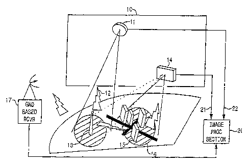
Figure 1 diagrammatically illustrates the passive RF energy collection and
processing
scheme as having a front end, RF energy collection section 10, which contains
a reference signal
collector (antenna) 11 to collect non-scattered RF energy 12 emitted by an RF
source 13 (such
CA 02428513 2003-05-12
WO 02/056053 PCT/USO1/46997
as a commercial television broadcast tower) illuminating a three-dimensional
volume of space
16 containing one or more cultural features 15 of interest (such as buildings
and contents
thereof). 'The front end section further includes a scattered image energy
collector 14 that
collects RF energy that has been scattered - reflected from various points of
the cultural features
15 of the illuminated terrestrial region.
The reference and scattered energy collectors may comprise respective
(airborne or
spaceboxne) RF -energy collection platforms, containing their own antenna and
receiver
subsystems. In an alternative configuration, both the reference signal
collector and the scattered
or image energy collector may use a common RF energy collector, or
respectively separate
to energy collectors located on the same platform. As a further variation, the
scattered energy
collector may be located on an airborne or spaceborne platform and the
reference signal
collector may comprise a ground-based receiver,17.
Regardless of the energy collection arrangement employed, scattered RF energy
collection is dynamic in plural non-coincident travel paths, to ensure that
energy collected from
1 s the terrestrial region of interest will be derived from mutually
orthogonal perspectives, thereby
gathering three-dimensionally scattered RF energy from cultural features in
the illuminated
region. Once captured by their respective energy receiver sections, the RF
reference signal
energy and the RF image energy are digitized and stored, for processing by
image processing
section 20.
20 Figure 3 diagrammatically illustrates the overall mechanism that is carried
out by the
image processing section to obtain a set of (spatially orthogonal scattering
coefficient values)
for the case of an arbitrary, illuminated location (pixel or voxel point p;),
defined by a respective
set of (three-dimensional) Cartesian coordinates (xi, yi, zi) within the
volume of space 16
illuminated by reference source 13. In terms of the diagrammatic illustration
of Figure 1, the
z5 source 13 of RF energy illuminating the three-dimensional spatial volume of
region 16 is
denoted as a reference signal source sa(t), assumed to be located at some
fixed known a priori
location in space, having coordinates (xo, yo, zo).
A respective location of a scattered RF energy collector 14 (as itmoves along
a respective
travel path 30 above and past the illuminated region 16) is defined by a set
of collection aperture
3 0 (a) coordinates (xa, ya, za), which may be readily provided by precision
navigation
insfirumentation, such as a GPS-based position location subsystem. The signal
processing
scheme of Figure 3 may be considered to be a'self-referential' embodiment, in
that the collector
24 is used to simultaneously collect both scattered RF energy from the
illuminated scene, as well
as non-scattered energy emitted from the reference signal source so(t).
Namely, a received signal
s
CA 02428513 2003-05-12
WO 02/056053 PCT/USO1/46997
y(t) produced by the RF energy collector 14 contains the direct path signal
sof t) from the source
13 to the collector 14, as well as time-delayed, Lorentz-transformed RF energy
that may be
scattered or reflected from the illuminated location pi, and incident upon the
collection aperture
(a) of the collector 14.
The signal Y(t) may be represented in equation (1) as:
Y~t) _ ~9~oa~roa) *~So~Yoa~~-~'roa~C) ~ +
~goia~il2~roiria) So~Y.ie ~t~ ~roi+ria) ~C~ )
i
where the first term corresponds to the direct path signal from the source
so(t); and the
second, summation term corresponds to the scattered signal from the
illuminated location pi.
The components of equation (1) may be defined as follows:
c = the speed of light;
1 o t = time as measured in the moving collection aperture (a) frame of the
collector 24;
goa = the gain power factor for the path from the source 13 to the aperture of
the moving
collector 14;
go;a = gain power factor for the path from the source 13 to the ith scatterer
at illuminated
location pi to the collection aperture of the collector 14;
roa = the distance from the source 13 to the collection aperture of the
collector 14;
roi = the distance from the source 13 to the ith scatterer;
r;a = the distance from the ith scatterer at illuminated location pi to the
collection aperture
of the collector 14;
Yoa = Lorentz time scaling for the path from the source 13 to the collection
aperture of
z o the collector 14;
Y;a = Lorentz time scaling for the path from the potential scatterer location
pi to the
collection aperture of the collector 14; and
of = the scattering coefficient for the ith scatterer at illuminated location
pi.
The Lorentz time scaling you may be defined as:
Yoa ' (1 ' roa~C)~(1 ' ~roa~C)Z)1/2
The Lorentz time scaling YIa may be defined as:
9
CA 02428513 2003-05-12
WO 02/056053 PCT/USO1/46997
Y~ - (1 ' rte/ c) / (1- (r~~ c)Z)1~2 (3)
The gain power factor goa may be expressed as:
~ goa ~ 2 - ~zGf(ao~)Gr(aoa)/16rr2, (4)
and the gain power factor go;a may be expressed as:
~ go~a I ~ ~ ~zGt(~o~)Gr(~a)/6'~, (5)
where
Gt, Gr are respective gains of the transmitting antenna of the illuminating
source 13 and
the receiver antennas) of collector 14,
the values a axe path unit vectors, and
to , A is the wavelength of the RF signal transmitted by source 13.
It should be noted that the coordinates (x0, yo, z0) of the reference signal
source sof t) need
not specify the exact location of the transmitter 13. As long as the
coordinates (xo, yo, zo) are
reasonably proximate to the actual location of the reference signal source
so(t), the processed
xesult for the illuminated location pi (and all others) will be spatially
shifted from the image
15 produced if the coordinates of the source 13 were known with precision; as
a consequence, the
generated scene will simply be a spatially shifted image, containing the same
resolvable cultural
details that would be obtained were the exact location of the phase center of
the transmitter's
emitted RF signal known a priori.
Because the coordinates (xo, yo, zo) of the source of the reference signal sof
t) are spatially
2 o displaced from the location (x;, yi, z;) of the illuminated point pi of
interest, there will be a time
delay shown by broken lines zoi associated with the reference signal's travel
path from the
source sof t) to the potential scattering location pi, and a time delay shown
by broken lines ioa
associated with the reference signal's txavel time from the reference signal
source sof t) to the RF
energy collection aperture at coordinates (xa, ya, za). In addition, broken
lines zia represent the
25 time delay associated with the travel time of the RF energy scattered from
the illuminated
location pi to the received image signal coordinates (xa, y~, za) of the
scattered image energy
collector 14.
In order to properly correlate the reference source signal sof t) emanating
from the source
13 with the RF energy signal y(t) received by the moving collector 14, it is
necessary to account
3 o for these delays, as well as the time-scaling of the signal xeceived by
the energy collector 14
resulting from the fact its platform is moving relative to the illuminated
location pi. 'These
adjustments are shown in the correlation signal processing diagram of Figure
4.
In particular, the received signal y(t) as collected by the collector 14 at
the RF energy
collection aperture coordinates (xa, ya, za) is applied to a first processing
path that includes a first
CA 02428513 2003-05-12
WO 02/056053 PCT/USO1/46997
Lorentz transform operator 41. This first Lorentz transform operator accounts
for the delay zo
and performs the first Lorentz transform you of the signal y(t) from its
movingframe of reference
at collection aperture location (xa, ya, za) to the static frame of reference
of illuminated location
p;.
The output of the first Lorentz transform operator 41 is then applied to a
delay 43, which
imparts a delay ioi associated with the reference signal's travel time from
the source sof t) to the
illuminated location pi. The combined effect of this first Lorentz transform
and delay operation
serves to transform the reference signal component of the energy received by
the collector 14
to the location pi. The output of delay 43 is coupled as a first input 42 of a
correlation multiplier
44.
The received signal y(t) is further applied to a second processing path that
includes a
second Loxentz transform operator 45, which accounts for the delay i;a and
performs a second
Lorentz transform y;~ of the received signal y(t) from its moving frame of
reference at location
(xa, Ya, za) to the static frame of reference of location pi. Because the
'self referential' system of
Figure 3 provides for the collection of both the scattered energy and
reference illumination
signals by means of a common energy collector 14, the received signal y(t)
also contains the
reference illumination signal soft) (which can be expected to be a substantial
or dominant
portion of the received signal).
In order remove the reference signal component sof t) from the desired
scattered image
zo component of the received signal y(t), the output of the second Lorentz
transform y;a operator
45 is coupled to a reference signal suppression or 'correlation discrirninant'
operator 47,~such
as the spectral inversion-based mechanism shown in Figure 5, that serves to
effectively null out
the amplitude of the reference signal component. For this purpose, the
received signal y(t) is
coupled as an input to a phase locked loop tracking operator 51, which
produces an output
2s representative of cos(2yoc,~ot). This frequency shifted signal is then
multiplied in a multiplier 53
by the signal y(t), to produce a spectral inversion of the received signal,
that places the desired
information signal (containing the scattered information) at a sideband of the
illuminating
reference. This spectrally inverted version of the received signal is then
differentially combined
with the received signal y(t) in differential combiner 55, which excises or
nulls out the spectrally
3 o coincidentreference componentin the two multiplied signals, leaving only
the desired scattered
energy component. The resultant reference-nulled signal output by the
reference signal
suppression operator 4~, which represents the scattered component of the
receive signal y(t) as
transformed to the illuminated location pi, is coupled as a second input 46 of
the correlation
multiplier 44.
11
CA 02428513 2003-05-12
WO 02/056053 PCT/USO1/46997
Where the scattered energy signal and the reference signal are collected by
separate
energy collectors, the signal y(t) provided by the energy collector 14 will
not contain a
potentially dominant reference signal component that requires removal, as
described above. In
this instance, as shown in Figure 6, the signal y(t) is applied only to the
Lorentz transform
operator 45, the output of which is coupled to the second input 4b of
multiplier 44. Also, where
a copy of the reference signal so f t) at illumination source location (xo,
yo, zo) is available, no
Lorentz transform of the illuminating reference signal is necessary; instead,
the reference signal
need only be coupled through a delay 43 to compensate for the travel time
delay zoi, with the
output of delay 43 being coupled to the first input 42 of the multiplier 44 as
described above.
1 o As shown in Figures 4 and 6, the multiplier 44 multiplies the reference
signal transform
Yo~ based component at its input 42 by the scattered signal transform Y;a
based component at its
input 46, so as to produce a product that is summed or integrated by a
correlation integrator 48.
The integration: period of integrator 48 is of a relatively long duration
(which may be on the
order of several tens of seconds to several tens of minutes, as a non-limiting
example), that is
1 s sufficient to ensure that only scattered energy values associated with RF
frequency from the
source soft) illuminating the location pi will constructively combine.
However, all others will
destructively cancel, leaving as a valid scattering coefficient information ci
for illuminated
location pi only that derived from reference signal energy emanating from the
transmission
reference signal source 13.
2o Figure ~ shows a reduced complexity implementation of the correlation
signal
processing diagram of Figure 4, where the differential Lorentz transform
operators are replaced
by a Doppler shift mechanism. In this case the Lorentz transform operator 41
is removed and
the Lorentz transform operator 45 is replaced by a multiplier 45M, to which
the signal y(t) and
the signal e~"~t~ are applied, where ~(t) = Lorentz (Yoa Y;~).
2s The scattering coefficient iizformation obtained from the mutually
orthogonally offset
dynamic.energy collection geometries and associated correlation-based image
processing is a
complex interference pattern (containing both amplitude and phase components)
having all the
information necessary to recreate a three-dimensional monochromatic image of
the cultural
features of the illuminated region 16. This scattering coefficient data may be
coupled to a
3 o downstream image utility subsystem 49, such as but not lirruted to a
virtual reality simulator,
multi-image slice display device, and the like, for generation of the three-
dimensional image
of the scene.
The resolution to which the illuminated scene may be imaged is limited by the
Rayleigh
wavelength (i.e., one-half the wavelength) of the illuminating reference
source so(t). As a non-
12
CA 02428513 2003-05-12
WO 02/056053 PCT/USO1/46997
limiting example, for an illuminating coherent RF frequency on the order of 50
MHz, the image
feature resolution may be on the order of ten feet, while for an illuminating
frequency on the
order of 500 MHz, the image feature resolution may be on the order of one
foot.
The present system collects and processing RF energy emanating from a single
s narrowband RF source, the wideband image generation system is operative to
collect and
process RF energy reflected - scattered from a three-dimensional space being
illuminated by a
plurality of RF energy sources. For purposes of providing a non-limiting
example of a reduced
complexity architecture of such a multi-emitter based system, Figure 8
diagrammatically shows
two narrowband signal sources 13-1 and 13-2.
to Like the source 13 in the system of Figure 1, narrowband signal sources 13-
1 and 13-2
may comprise commercial television transmitters broadcasting at respectively
different
frequencies, and located in illumination proximity to the terrestrial region
16 containing cultural
features (e..g., buildings and contents thereof) 15 of which a two-dimensional
image is to be
generated. It should be observed, however, that the present invention is not
limited to the use
15 of two or any other multiple number of spectrally diverse narrowband RF
signal sources. From
a practical standpoint, it can be expected that the wideband illumination RF
energy would be
a composite of energy sourced from some N number of narrowband sources, as
shown in the
spectrum diagram of Figure 9.
In addition, in the system of Figure 8, the dynamic platform carrying the
scattered RF
2o energy collector 14 and/or the reference signal collector 11 is shown as
traveling along a path
80. During some prescribed (azimuth-associated) travel window 82 of the energy
capture
platform within this path (which may have a duration on the order of several
seconds to tens
of seconds, for example, as described above), the RF energy collection system
10 is turned on.
During this active interval, the energy collection system operates in the same
manner as the
2s system of Figure 1, described above, so as to gather, for each of the
narrowband illumination
sources, respective sets of RF reference signal energy and scattered RF
energy. As in the signal
illumination source-based system of Figure 1, each set of collected energy
data is digitized and
stored, for processing by processing section 20.
Thus, while the components and operation of the energy collection portion of
the system
3 0 of Figure 8 are essentially the same as those of Figure 1, the system of
Figure 8 differs from thaf
of Figure 1 in two respects. First, as in an SAR application, the terrestrial
region 16 to be imaged
is actively viewed (from which wideband rather than narrowband energy is
collected) during
only a prescribed window 82 (which corresponds to the spatial resolution of an
azimuth
component of a to-be-generated two-dimensional image) of the dynamic
observation platform
13
CA 02428513 2003-05-12
WO 02/056053 PCT/USO1/46997
as it travels along path 80. Secondly, rather than collecting a single set of
data for one
narrowband frequency (source 13 in Figure 1), the system of Figure 8 collects
a composite of
wideband data corresponding to a plurality of N data sets, respectively
associated with the
number N of spectrally diverse narrowband RF energy sources (two of which are
shown at 13-1,
s 13-2) illuminating the region 16
Within the processing section 20, each collected data set as derived for a
respectively
different one of the naxrowband illumination sources is processed as described
above with
reference to Figures 3-~. As a result, for the wideband embodiment of the
present invention,
plural N sets of scattering coefficients, respectively associated with the N
narrowband
1 o illumination sources are obtained. As noted above, the respective RF
frequencies of this set of
N illumination sources can be expected to mutually non-coherent. As a
consequence, in order
to realize a useful image, the phase components of the respective N sets of
scattering coefficients
obtained by the image processing system must be adjusted to correct for their
mutually
differential offsets.
15 Figure 10 shows a wideband image processing mechanism 21 that is executed
within the
processing section 20 to correct for this phase incoherence. In order to
provide a phase
coherency correction reference for different scattering coefficient data sets,
it is necessary to tie
respective ones of the data sets ,to one another. As pointed out above, this
may be readily
accomplished by searching fox one or more of the same relatively well defined
cultural features,
zo such as a cornea or edge, in multiple ones (and preferably all of the data
sets).
For this purpose, a respective ith scattering coefficient data set of the N
sets of data 100
is coupled to a cultural feature extraction operator 101. As a non-limiting
example, the cultural
feature extraction operator employed may comprise a conventional edge
detection operator. The
geometry parameters of the cultural feature located in the ith scattered
coefficient data set by
z s the culturalfeature extraction operator 101 are coupled to a standard
electromagnetic waveform
analysis operator 202. Tn addition, culturalfeature extraction operator 102
outputs the scattering
coefficients for the ith data points that lie along the extracted feature.
The electromagnetic waveform analysis operator 102 is operative to calculate a
set of
theoretical scattering coefficients that should be produced as a result of an
illumination by that
3 o ith frequency of spatial points that lie along the extracted cultural
feature. The phase values of
these calculated scattering coefficients are then compared in a comparator 103
with the actual
measured phase values of the-scattering coefficients of the ith data set, as
output by cultural
feature extraction operator 101.
The difference between the phase values of the two sets of coefficients (tool-
calculated
14
CA 02428513 2003-05-12
WO 02/056053 PCT/USO1/46997
and energy collection-based) fox the extracted cultural feature as derived by
comparator 103 is
coupled to a scattering coefficient correction operator 104, which adjusts
each of the measured
scattering coefficient values for all spatial points in the ith data set by
the determined phase
difference. Once this phase correction has been made for a given illumination
frequency, all of
the scattering coefficients for that ith set of scattering coefficient data
associated with that ith
particular illumination frequency are effectively tied to a common phase
coherence reference.
This enables scattering coefficients of the ith set to be coherently combined
with those
of another jth set of scattering coefficients whose phase components have been
similarly
corrected, based upon the same extracted cultural feature. Also, a given
cultural feature that is
1 o common to two or more (e.g., ith and (i+k)th data sets may notbe cornxnon
to the (1-N) data sets
for all N frequencies. In this case, one or more additional cultural features
may need to be
extracted in order to phase-coherence link all of fhe data sets together.
After the N sets of
scattering coefficients have been phase corrected in the manner described
above, they are
coherently combined at 105 to provide a composite wideband scattering
coefficient data set. As
is the coordinates of this data set are defined in the azimuth and range
dimensions only, the data
set can be used to generate a two-dimensional image of the viewed region, as
shown at 106.
The passive imaging system takes advantage of RF daylight created by multiple
narrowband RF illumination sources, to passively produce respective sets of RF
scattering
coefficients associated with the frequencies of the plural illumination
sources for multiple points
z o within a prescribed region illuminated by the RF transmitters. The
scattering coefficients of each
respectively different frequency set provide a complex interference pattern
having amplitude
and phase components and containing information necessary to recreate a two-
dimensional
image of the illuminated scene.
To correct for the lack of mutual coherence among different RF illumination
sources, the
a s respective sets of scattering coefficient data obtained for each
narrowband illumination source
are applied to a cultural feature extraction operator, to locate one or more
strong cultural
features spatially common to multiple images. For spafiial points along the
extracted cultural
feature theoretical scattering coefficients are calculated. Differences
between phase values of
these calculated scattering coefficients and those of the collected and
processed scattering
3 o energy are used to modify the measured scattering coefficient values for
all spatial points in the
illuminated region. This allows the scattering coefficients of that narrowband
frequency set to
be coherently combined with those of another spectrally different narrowband
set of scattering
coefficients whose phase components have been similarly corrected, based upon
the same
extracted cultural feature.
CA 02428513 2003-05-12
WO 02/056053 PCT/USO1/46997
An imaging system uses wideband 'RF daylight' created by plural narrowband RF
illumination sources, to passively generate spectrally different sets of RF
scattering coefficients
for multiple points within a prescribed three-dimensional volume being
illuminated by the
narrowband RF transmitters. To correct for the lack of mutual coherence among
different RF
s illumination sources, the respective sets of scattering coefficient data are
applied to a cultural
feature extraction operator, to locate one or more strong cultural features
spatially common to
multiple images. For spatial points along the extracted cultural feature
$ieoretical scattering
coefficients are calculated. Differences between phase values of these
calculated scattering
coefficients and those of the collected and processed scattering energy are
used to modify the
to measured scattering coefficient values for all spatial points in the
illuminated region.
16