Note : Les descriptions sont présentées dans la langue officielle dans laquelle elles ont été soumises.
CA 02478157 2004-09-03
WO 03/076969 PCT/US03/05970
METHOD AND APPARATUS FOR THE USE OF MULTICOMPONENT
INDUCTION TOOL FOR GEOSTEERING AND FORMATION
RESISTIVITY DATA INTERPRETATION IN HORIZONTAL WELLS
Gulamabbas Merchant, Otto Fanini, Berthold Kriegshauser & Liming Yu
BACKGROUND OF THE INVENTION
Field of the Invention
[0001] The invention is related generally to the field of electrical
resistivity well
logging methods. More specifically, the invention is related to methods for
using
multi-array induction and multi-component induction measurements for
geosteering,
reservoir navigation and open hole applications involving formations that may
be
anisotropic.for geosteering and open hole applications involving anisotropic
formations.
Description of the Related Art
[0002] Electromagnetic induction and wave propagation logging tools are
commonly
used for determination of electrical properties of formations surrounding a
borehole.
These logging tools give measurements of apparent resistivity (or
conductivity) of the
formation that, when properly interpreted, reasonably determine the
petrophysical
properties of the formation and the fluids therein.
[0003] The physical principles of electromagnetic induction resistivity well
logging
are described, for example, in H.G. Doll, Introduction to Induction Logging
and
Application to Logging of Wells Drilled with Oil-Based Mud, Journal of
Petroleum
Technology, vol. 1, p.148, Society of Petroleum Engineers, Richardson, Tex.
(1949).
Many improvements and modifications to electromagnetic induction resistivity
instruments have been devised since publication of the Doll reference, supra.
Examples of such modifications and improvements can be found, for example, in
U.S.
Pat. No. 4,837,517; U.S. Pat. No. 5,157,605 issued to Chandler et al.; and
U.S. Pat.
No. 5,452,761 issued to Beard et al.
1
CA 02478157 2004-09-03
WO 03/076969 PCT/US03/05970
[0004] A typical electrical resistivity-measuring instrument is an
electromagnetic
induction military well logging instrument such as described in U.S. Pat. No.
5,452,761 issued to Beard et al. The induction logging instrument described in
the
Beard `761 patent includes a number of receiver coils spaced at various axial
distances from a transmitter coil. Alternating current is passed through the
transmitter coil, which induces alternating electromagnetic fields in the
earth
formations. Voltages, or measurements, are induced in the receiver coils as a
result of
electromagnetic induction phenomena related to the alternating electromagnetic
fields. A continuous record of the voltages form curves, which are also
referred to as
induction logs. The induction instruments that are composed of multiple sets
of
receiver coils are referred to as multi-array induction instruments. Every set
of
receiver coils together with the transmitter is named as a subarray. Hence, a
multi-
array induction consists of numerous subarrays and acquires measurements with
all
the subarrays.
[0005] Voltages induced in the axially more distal receiver coils are the
result of
electromagnetic induction phenomena occurring in a larger volume surrounding
the
instrument, and the voltages induced in the axially proximal receiver coils
are the
result of induction phenomena occurring more proximal to the instrument.
Therefore,
different receiver coils see a formation layer boundary with different
shoulder-bed
contributions, or shoulder-bed effects. The longer-spaced receiver coils see
the
formation layer boundary at further distance from the boundary than the
shorter-
spaced receiver coils do. As a result, the logs of longer-spaced receiver
coils have
longer shoulder-bed effects than the logs of shorter-spaced receiver coils.
The logs of
all the receiver coils form a certain pattern.
[0006] If the layers are not perpendicular to the axis of the instrument, the
conductivity of the media surrounding the instrument can vary azimuthally,
causing
the inferences about the conductivity from the measurements of the induction
voltage
to be in error. A method for correcting the error is described in U.S. Pat.
No.
5,774,360 issued to Xiao and Zhou. The method requires the relative dip angle
as a
2
CA 02478157 2004-09-03
WO 03/076969 PCT/US03/05970
priori information. The relative dip angle is the angle between the borehole
axis and
the normal of the bedding plane. Because the formation layers can also be
inclined,
the relative dip angle is normally unknown even though the wellbore deviation
is
known. U.S. Pat. No. 6,049,209 issued to Xiao and Geldmacher teaches another
method has also been developed to interpret induction logs in the environments
of
relative inclination and anisotropy. The method requires the relative dip
angle and
the anisotropy coefficient as a priori information. The anisotropy coefficient
can be
defined as the ratio between the resistivity perpendicular to bedding and the
resistivity
parallel to bedding.
[0007] A limitation to the electromagnetic induction resistivity well logging
instruments known in the art is that they typically include transmitter coils
and
receiver coils wound so that the magnetic moments of these coils are
substantially
parallel only to the axis of the instrument. Eddy currents are induced in the
earth
formations from the magnetic field generated by the transmitter coil, and in
the
induction instruments known in the art. These eddy currents tend to flow in
ground
loops which are substantially perpendicular to the axis of the instrument.
Voltages
are then induced in the receiver coils related to the magnitude of the eddy
currents.
Certain earth formations, however, consist of thin layers of electrically
conductive
materials interleaved with thin layers of substantially non-conductive
material. The
response of the typical electromagnetic induction resistivity well logging
instrument
will be largely dependent on the conductivity of the conductive layers when
the layers
are substantially parallel to the flow path of the eddy currents. The
substantially non-
conductive layers will contribute only a small amount to the overall response
of the
instrument and therefore their presence will typically be masked by the
presence of
the conductive layers. The non-conductive layers, however are those layers
which are
typically hydrocarbon-bearing and are of the most interest to the instrument
user.
Some earth formations which might be of commercial interest therefore may be
overlooked by interpreting a well log made using the electromagnetic induction
resistivity well logging instruments known in the art.
3
CA 02478157 2004-09-03
WO 03/076969 PCT/US03/05970
[0008] United States Patent 5,999,883 issued to Gupta et al., (the "Gupta
patent"), the
contents of which are fully incorporated here by reference, discloses a method
for
determining the horizontal and vertical conductivity of anisotropic earth
formations.
Measurements are made of electromagnetic induction signals induced by
induction
transmitters oriented along three mutually orthogonal axes. One of the
mutually
orthogonal axes is substantially parallel to a logging instrument axis. The
electromagnetic induction signals are measured using first receivers each
having a
magnetic moment parallel to one of the orthogonal axes and using second
receivers
each having a magnetic moment perpendicular to one of the orthogonal axes
which is
also perpendicular to the instrument axis. A relative angle of rotation of the
perpendicular one of the orthogonal axes is calculated from the receiver
signals
measured perpendicular to the instrument axis. An intermediate measurement
tensor
is calculated by rotating magnitudes of the receiver signals through a
negative of the
angle of rotation. A relative angle of inclination of one of the orthogonal
axes which
is parallel to the axis of the instrument is calculated, from the rotated
magnitudes,
with respect to the direction of the vertical conductivity. The rotated
magnitudes are
rotated through a negative of the angle of inclination. Horizontal
conductivity is
calculated from the magnitudes of the receiver signals after the second step
of
rotation. An anisotropy parameter is calculated from the receiver signal
magnitudes
after the second step of rotation. Vertical conductivity is calculated from
the
horizontal conductivity and the anisotropy parameter.
[0009] Shoulder bed corrections related to the effect of formations above and
below
the depth being evaluated also have to be applied to the data. Methods for
making
these corrections to data acquired with conventional logging tools are well
known in
the art.
[0010] For example, United States Patent 5,446,654 to Chemali teaches the
conversion of a resistivity log as a function of well depth into a
rectangularized curve
so that the interfaces of the adjacent strata are located, and a suitable
number of
iterations, a correction factor is applied. The corrected rectangular log is
obtained
4
CA 02478157 2004-09-03
WO 03/076969 PCT/US03/05970
with a correction coefficient computed at each depth. For each computation,
the
impact of all the strata within a specified depth window is considered, while
strata
beyond that window are simplified by representing the strata beyond the window
with
single equivalent bed values to reduce the number of computations required.
This
then provides a resistivity log which is substantially free of shoulder bed
effect.
[0011] The method of U.S. Pat. 5,867,806 to Strickland et al. corrects for
shoulder
bed effect in LWD resistivity logs through inversion. The method selects one
or more
control depths at one or more locations of each of a plurality of detected
beds in the
formation. The method then estimates the resistivity of each bed only at the
selected
control depths to produce an estimated resistivity of the beds. The method
then
computes a simulated log value at each control depth using a current estimate
of the
resistivity of the beds. The computer-simulated log is then computed to the
actual log
data at each control depth, and the resistivity of each bed is adjusted using
the
difference between the actual and simulated values at the control depths. The
method
iteratively repeats a plurality of times until the simulated log substantially
matches the
actual log at the control depths.
[0012] Electrically anisotropic reservoirs are encountered frequently in
hydrocarbon
exploration. For accurate saturation estimation and optimum hydrocarbon
recovery
from these reservoirs, it is essential to detect and properly describe their
electrical
properties. For example, in laminated sand-shale sequences or sands with
different
grain size distributions, the vertical resistivity (perpendicular to the
bedding) is more
indicative of the hydrocarbon content than the horizontal resistivity
(parallel to the
bedding). However, the response measured by conventional induction tools with
their
transmitter-receiver coil moments oriented normal to bedding is dominated by
the
horizontal resistivity. Therefore, a petrophysical evaluation based on these
data can
either overlook hydrocarbons present in laminated sands or underestimate their
productivity.
[0013] The relative formation dip angle is vital for proper and accurate
interpretation
CA 02478157 2004-09-03
WO 03/076969 PCT/US03/05970
of data acquired by the new multi-component induction instrument. This newly
developed induction instrument comprises three mutually orthogonal transmitter-
receiver arrays. These configurations allow us to determine both horizontal
and
vertical resistivities for an anisotropic formation in vertical, deviated, and
horizontal
boreholes. A description of an early version of the tool can be found
inUS6147496 to
Beard et al, the contents of which are incorporated herein by reference. The
transmitters induce currents in all three spatial directions and the receivers
measure
J. In this nomenclature of the
the corresponding magnetic fields (Hxx, Ham, and H,
field responses, the first index indicates the direction of the transmitter,
the second
index denotes the receiver direction. As an example, HZZ is the magnetic field
induced
by a z-direction transmitter coil and measured by a z-directed receiver. The z-
direction is parallel to the borehole. In addition, the instrument measures
all other
cross-components of the magnetic fields, i.e., Hxy, HxZ, Hyx, HyZ, HZX, and
HZy.
[0014] The signals acquired by the main receiver coils (Hxx, Ham, and Hzz) are
used to
determine both the horizontal and vertical resistivity of the formation. This
is done
by inverse processing techniques of the data. These inverse processing
techniques
automatically adjust formation parameters in order to optimize in a least-
square sense
the data match of the synthetic tool responses with measured data. Required
inputs in
this process are accurate information of the relative formation dip and
relative
formation azimuth. This information can be derived using in addition to the
main
signals (Hxx, H õ and Ham) the data from the cross-components.
[0015] Conventional induction tools comprising only coaxial transmitter-
receiver coil
configurations do not have azimuthal sensitivity. Therefore, in a horizontal
wellbore,
the data do not contain information about directionality of the formation. It
is not
possible to distinguish whether a layer is above or below the borehole from
these data
alone. There is a need to be able to determine directionality of the
formation. This
knowledge can be obtained using a subset or all of the cross-components of the
new
multi-component induction tool allows determination of directionality of the
formation.
6
CA 02478157 2004-09-03
WO 03/076969 PCT/US03/05970
[0016] Another use of multicomponent resistivity tools is in navigation in
anisotropic
reservoirs. An example of the use of resistivity is given in US Patent RE35386
to Wu
et al, having the same assignee as the present application and the contents of
which
are fully incorporated herein by reference. Disclosed in Wu is a method for
detecting
and sensing boundaries between strata in a formation during directional
drilling so
that the drilling operation can be adjusted to maintain the drillstring within
a selected
stratum is presented. The method comprises the initial drilling of an offset
well from
which resistivity of the formation with depth is determined. This resistivity
information is then modeled to provide a modeled log indicative of the
response of a
resistivity tool within a selected stratum in a substantially horizontal
direction. A
directional (e.g., horizontal) well is thereafter drilled wherein resistivity
is logged in
real time and compared to that of the modeled horizontal resistivity to
determine the
location of the drill string and thereby the borehole in the substantially
horizontal
stratum. From this, the direction of drilling can be corrected or adjusted so
that the
borehole is maintained within the desired stratum. The resistivity
measurements
made in Wu are made with a conventional electromagnetic (EM) propagation
resistivity instrument. The measurements made with a propagation EM tool lack
directional information.
[0017] It would be desirable to have a method of logging in anisotropic
formations
that can determine borehole deviation relative to the bedding. Such a method
should
preferably be have directionality information and be suitable for use in
reservoir
navigation. The present invention satisfies this need.
SUMMARY OF THE INVENTION
[0018] The present invention is a method of determining a parameter of
interest of an
earth formation having a plurality of layers. A logging tool is conveyed into
a
borehole in a selected layer in the earth formation, the borehole having an
axial
direction inclined at a angle to a normal to said layers. At a selected
frequency, a
plurality of multi-component and/or array resistivity measurements indicative
of the
parameter of interest are obtained. Using an obtained resistivity value for
each of
7
CA 02478157 2004-09-03
WO 03/076969 PCT/US03/05970
the plurality of layers; the multicomponent resistivity measurements are
processed to
obtain the parameter of interest. In a preferred embodiment of the invention,
the
parameter of interest is a distance to a boundary between a pair of layers.
The
logging tool may be conveyed into the borehole on either a wireline or on a
drillstring. The obtained resistivity values may come from a previously
drilled
borehole.
[0019] In a preferred embodiment of the invention, principal component
measurements are made in which the coil axes are aligned either parallel to or
orthogonal to the tool axis. In alternate embodiments of the invention,
measurements
made with coils inclined at other angles to the tool axis may be used; or
measurements made through a slotted antenna cover are made. In either case, a
sufficient number of independent measurements need to be made to be able to
define
principal components.
[0020] An earth model is defined from the previously obtained resistivity.
Using the
earth model and the tool response, expected multicomponent measurement values
are
predicted along a planned well trajectory. Differences between the actual
measurements and the model outputs may be used to alter the drilling
direction. In
one embodiment of the invention, a distance to a bed boundary is determined
using a
distance indicator. The distance indicator is based upon combinations of
multicomponent measurements. This distance indicator may be used in reservoir
navigation for maintaining the borehole at a desired distance from a fluid
interface
such as an oil-water contact.
BRIEF DESCRIPTION OF THE DRAWINGS
[0021] The invention is best understood by reference to the following figures
wherein
like numbers refer to like components
FIG. 1 depicts a sketch of the new 3DEX multi-component induction tool.
8
CA 02478157 2004-09-03
WO 03/076969 PCT/US03/05970
FIG. 2 shows an example of two simulated cases of horizontal formations.
FIG. 3 shows a graph of a typical six-level anisotropic turbidite sequence
along with
responses of the five components to the applied RF magnetic field at 20 kHz.
FIG. 4 shows a graph of a six-level isotropic sequence along with responses of
the
five components to the applied RF magnetic field at 20 kHz.
FIG. 5 shows a graph of the sequence of Fig. 4 with altered resistivities at
the first bed
layer along with responses of the five components to the applied RF magnetic
field at
20 kHz.
FIG. 6 shows a graph of the sequence of Fig. 4 with altered resisitivities at
the sixth
bed layer along with responses of the five components to the applied RF
magnetic
field at 20 kHz.
FIG. 7 shows a graph of a three-level linearly graded transition sequence
along with
responses of the five components to the applied RF magnetic field at 20 kHz.
FIG. 8 shows a graph of a thick resistive bed sandwiched between two
conductive
beds along with responses of the five components of the applied RF magnetic
field at
20 kHz.
FIG. 9 shows a graph of a thick conductive bed sandwich between two resistive
beds
with responses of the five components of the applied RF magnetic field at 20
kHz.
FIG. 10 shows the five component responses to the applied 200-kHz RF magnetic
field as the invention is rotated through 180 degrees inside a horizontal
borehole
within the second bed of Figure 4.
FIG. 11 shows the five component responses to the applied 20-kHz RF magnetic
field
as the invention is rotated through 180 degrees inside a horizontal borehole
within the
second bed of Figure 4.
FIG. 12 shows a multi-component 3DEX induction configuration of the invention
for
vertical wells.
FIG. 13a shows a plot of a model of formation resistivity against logging
depth, with
three anisotropic resistivity intervals.
FIG. 13b shows a model of the responses of HXX and Hz, in both isotropic and
anisotropic materials of Fig 13a.
FIG. 14 shows a multi-component induction configuration of the invention for
9
CA 02478157 2004-09-03
WO 03/076969 PCT/US03/05970
horizontal wells.
FIG. 15 shows a configuration for a deviated well in an earth formation.
FIG. 16 is a flow chart illustrating some of the embodiments of the present
invention.
FIG. 17 shows a plot of a distance indicator for a model example at a
frequency of
20kHz.
FIG. 18 shows a plot of a distance indicator for a model example at a
frequency of
55kHz.
FIGS. 19a, 19b show the use of a slotted antenna cover or inclined coils with
the
method of the present invention.
DESCRIPTION OF PREFERRED EMBODIMENT
[0022] Figure 1 shows the configuration of transmitter and receiver coils in a
preferred embodiment of the 3DExplorerTM (3DEX) induction logging instrument
of
Baker Hughes. The basic concepts of the logging instrument have been described
in
the Gupta patent referenced above. Three orthogonal transmitters 101, 103, and
105
that are referred to as the T, T, and Ty transmitters are placed in the order
shown.
The three transmitters induce magnetic fields in three spatial directions. The
subscripts (x, y, z) indicate an orthogonal system substantially defined by
the
directions of the normals to the transmitters. The z-axis is chosen to be
along the
longitudinal axis of the tool, while the x-axis and y-axis are mutually
perpendicular
directions lying in the plane transverse to the axis. Corresponding to each
transmitter
101, 103, and 105 are associated receivers 111, 113, and 115, referred to as
the Rx, R,
and RY receivers, aligned along the orthogonal system defined by the
transmitter
normals, placed in the order shown in Figure 1. R,, R, and RY are responsible
for
measuring the corresponding magnetic fields HXx, HZZ, and HYY. Within this
system for
naming the magnetic fields, the first index indicates the direction of the
transmitter
and the second index indicates the direction of the receiver. In addition, the
receivers
RY and RZ, measure two cross-components, H,Y and H,, of the magnetic field
produced by the T,, transmitter (101). This embodiment of the invention is
operable
in single frequency or multiple frequency modes. It should further be noted
that the
description herein with the orthogonal coils and one of the axes parallel to
the tool
CA 02478157 2004-09-03
WO 03/076969 PCT/US03/05970
axis is for illustrative purposes only. Additional components could be
measured, and,
in particular, the coils could be inclined at an angle other than 0 or 90 to
the tool
axis, and furthermore, need not be orthogonal; as long as the measurements can
be
"rotated" or "projected" onto three orthogonal axes, the methodology described
herein is applicable.
. Measurements may also be made at a plurality of frequencies, and/or at a
plurality
of transmitter-receiver distances.
[0023] As an example of the sensitivity to directionality of the 3DEX tool, a
bed layer
configuration illustrated in Figure 2 and response value are tabulated in
Table 1.
Table 1.
Magnetic field response Casel Case2
A/m
Hxx 8.86777008E-04 8.86777008E-04
Hxy -1.99889226E-04 -1.99889226E-04
Hxz 2.45139177E-04 -2.45139207E-04
Hyy 1.11758942E-03 1.11758942E-03
Hyx 1.99889240E-04 1.99889240E-04
Hyz -1.41531185E-04 1.41531200E-04
Hzz 1.16889027E-03 1.16889027E-03
The configuration in Figure 2 is comprised of two cases of three-layered
media, labeled
Case 1 and Case 2. In both cases, the middle layers 213 and 223 are 1 in thick
and have
a horizontal resistivity (Rh) of 4 Q-m and a vertical resistivity (RJ of 10 0-
m. In Case
1, the Rh and R, are both 1 Q-m in the top layer 211 and 2 S2-m in the bottom
layer 215.
In Case 2, the resistivities are interchanged from Case 1, with a Rh and Rv
both equal to
2 Q-m in the top layer 221 and 1 Q-m in the bottom layer 225. In both cases,
the
relative dip of the borehole is 90 degrees (horizontal borehole) and azimuth
angle is 30
degrees. The configuration is shown in Figure 15, with TZ pointing out of the
page, Tx
(1501) aligned with its normal at an angle of 30 to the vertical, and Ty
(1502) aligned
with its normal at an angle of 60 to the vertical.
[0024] Table 1 shows the magnetic fields responses for the 3DEX instrument
taken
11
CA 02478157 2004-09-03
WO 03/076969 PCT/US03/05970
while positioned in the middle of the center layer. The responses are
normalized to a
unit transmitter-receiver moment and are for an excitation frequency of 20
kHz. The
normalized field responses are in units A/m. These simple results demonstrate
that
although Hxx, Hyy, and H,
,z are insensitive to directionality, the Hxy and Hxz components
(shown in bold in Table 1) are sensitive to directionality in a horizontal
wellbore. With
this knowledge, a practitioner of the art can discriminate whether a layer is
above or
below the borehole trajectory and thus can use said knowledge for geo-steering
purposes.
[0025] Figure 3 shows a case (Case 3) of a typical anisotropic turbidite layer
sequence.
The lithology sequence from top to bottom of the model is shale, thick sand,
followed
by a transition to a low resistivity and electrically anisotropic sand-shale
sequence. The
resistivities of this bed layer structure are tabulated in Table 2.
Table 2
Resistivity Bed Depth top boundary (ft) Rh 0-m Rv Q-m
1 -10 0.6 0.6
2 0 12 12
3 10 6 6
4 12 3 3
14 1.5 5
6 24 0.8 0.8
It is to be noted that Figs. 3-9 do not show tool responses as a tool is moved
along a
wellbore: in each of the figures, the borehole is horizontal. What is shown is
the
response of the tool in a fixed position within a horizontal (or highly
deviated)
borehole placed at a varying distance with respect to the top resistivity
layer interface
described by the curve "Layer" The sequence contains six overall bed layers,
the
resistivity of all layers being isotropic except for the fifth bed layer. The
anisotropic
fifth layer (between 15 and 25 feet of depth) has Rh = 1.5 Q-m and R, = 5 Q-m
The
tool operates at multiple frequencies. Only the 20 kHz response is shown here.
In
12
CA 02478157 2004-09-03
WO 03/076969 PCT/US03/05970
thick beds, when the boundaries are more than 5 feet away from the tool, the
HXZ
response is zero (301). The HXZ response starts showing sensitivity to a bed
boundary
when that bed boundary is within 5 feet of the tool. If the tool is moving
from a
region of low resistivity to a region of high resistivity, HXZ has a negative
response
(303). Similarly, when the tool is moving from a region of high resistivity to
a region
of low resistivity, the HXZ response is positive (305 and 307). HZZ
experiences a
positive deflection in the isotropic (fifth) bed layer (310), but experiences
a larger
deflection as the tool enters the isotropic sixth bed layer (312).
[0026] A comparison can be made between Case 3 in Figure 3 and Case 4 in
Figure 4.
Figure 4 shows a bed layer structure having a resistivity that is completely
isotropic at
all bed layers, including an isotropic fifth bed layer. The resistivities of
this bed layer
structure are tabulated in Table 3. Compare the values in bold face with the
corresponding values in Table 2.
Table 3
Resistivity Bed Depth top boundary Rh (Q-m) Rv (Q-m)
(ft)
1 -10 0.6 0.6
2 0 12 12
3 10 6 6
4 12 3 3
14 1.5 1.5
6 24 0.8 0.8
In Case 4, R, and Rh are both equal to 1.5 S2-m at the fifth bed layer. The
HXZ
component in Figure 4 is not different substantially from the HXZ response in
Figure 3,
even along transitions into and out of the isotropic fifth bed. There is
however a
noticeable influence on HZZ component as the tool crosses the boundary between
the
fourth and fifth bed layers. Comparing (310) in Figure 3 with (410) in Figure
4,
shows the dampening effect anisotropy had on the HZZ component.
13
CA 02478157 2004-09-03
WO 03/076969 PCT/US03/05970
[0027] Figure 5 shows a bed layer sequence with a single variation on Case 4
of
Figure 4. The horizontal and vertical resistivities at the first depth are
equal to 2 Q-m
in Figure 5 whereas the corresponding resistivities are 0.6 Q-m in Figure 4.
The
resistivities of this bed layer structure are tabulated in Table 4
Table 4
Resistivity Bed Depth top boundary Rh (Q-m) Rv (Q-m)
(ft)
1 -10 2 2
2 0 12 12
3 10 6 6
4 12 3 3
14 1.5 1.5
6 24 0.8 0.8
In the new formation of Figure 5, corresponding to the reduced differences in
the
resistivities of the first and second bed layers, there is less deflection of
the HXZ
component crossing from the first bed to the second bed (503) compared to
(403) in
Figure 4. The magnitude of the negative deflection of H,,, (511) is also
reduced from
it's the deflection (411) in Figure 4. -
[0028] The bed layer structure in Figure 6 shows another single variation on
the
sequence of Figure 4. In Figure 6, the sixth depth level has R. and R, equal
to 2 0-m
where the resistivity is 0.8 Q-m in Figure 4. The resistivities of this bed
layer
structure are tabulated in Table 5.
Table 5
Resistivity Bed Depth top boundary (ft) Rh S2-m Rv Q-m
1 -10 0.6 0.6
2 0 12 12
3 10 6 6
4 12 3 3
5 14 1.5 1.5
6 24 2 2
Whereas in Figure 4 the fifth bed layer is more resistive than the sixth bed
layer, in
Figure 6 the sixth bed layer is more resistive in all directions than the
fifth bed layer.
14
CA 02478157 2004-09-03
WO 03/076969 PCT/US03/05970
As a result, the deflection of HXZ (607) is opposite the direction of the
deflection in
Figure 4 (407) across this boundary. As the tool moves from fifth level to the
sixth
level, the response of the HZZ component (610) also reverses its deflected
direction from
Figure 4 (410).
[0029] Figure 7 shows a linearly graded transition region which lies between 0
and 10
feet between a comparatively low resistivity bed (1 Q-m) and a comparatively
high
resistivity bed (11 Q-m). The resistivities of this bed layer structure are
tabulated in
Table 6.
Table 6
Resistivity Bed Depth top boundary (ft) Rh (0-m) Rv (0-m)
1 -10 1 1
2 0 Linear grading Linear grading
3 10 11 11
At all levels, the resistivity is isotropic. The deflection of HXZ depends on
the
conductivity profile. In the beginning of the transition zone, the deflection
of HXZ (703)
is large because the slope of the conductivity profile (reciprocal of
resistivity) is large.
At the end of the zone, the conductivity slope is smaller, and therefore HXZ
(705) does
not detect the transition into the third bed. Again, the deflection in the
entire region is
negative because the resistivity is increasing.
[0030] Figure 8 shows a case of a thick resistive bed sandwiched between two
conductive beds. The sequence corresponds to a top level of shale, a middle
thick
resistive sand level, and a bottom level of shale. The resistivities of this
bed layer
structure are tabulated in Table 7.
Table 7
CA 02478157 2004-09-03
WO 03/076969 PCT/US03/05970
Resistivity Bed Depth top boundary (ft) Rh (Q-m) Rv Q-m
1 -10 1 1
2 0 10 10
3 10 1 1
The deflection of HXZ (801) is negative at the boundary at a depth of 0 feet
and has the
same order of magnitude as the corresponding deflection in Figure 3.
Similarly, at the
boundary between the beds at 25 feet, the deflection of HXZ (803) is positive
as the tool
crosses into the layer of lower resistivity. HZZ responses are also consistent
with the
results of Figure 4.
[0031] Figure 9 shows the converse situation from that in Figure 8, wherein a
conductive bed layer is sandwiched between two resistive bed layers. The
resistivities
of this bed layer structure are tabulated in Table 8.
Table 8
Conductive Bed Depth top boundary (ft) Rh S2-m Rv Q-m
1 -10 10 10
2 0 1 1
3 10 10 10
The HXZ signal has a positive deflection (901) for the boundary at which the
resistivity
decreases with depth and a negative deflection (903) where the resistivity
increases with
depth.
[0032] Figures 10 and 11 show graphs of response curves of a horizontal
borehole
centered at the midpoint (depth of 5 feet) of the second bed layer of Figure
4. In the
horizontal position, the layer above has different resistivities than the
layer below,
having consequences for the magnetic responses. The depth of the tool is
fixed, and
the tool is rotated about its longitudinal axis over a 180 0 variation of the
toolface angle .
In Figure 10, the tool is operated at 200 kHz. Since the tool is horizontal,
the HZZ
(1001) component is constant with rotation. The HYY (1003) and HXX (1005)
components
show a variation with toolface angle and interchange their values around a
mean value
as the tool rotates. It can be shown that the average of HXX and HYY is a
constant
16
CA 02478157 2004-09-03
WO 03/076969 PCT/US03/05970
independent of rotation. However, tool dip, location and the formation type do
affect
the values of the responses. The angular period of sinusoidal variation with
respect to
the relative azimuthal angular orientation of HXX and HYY is half a rotation
(180 0)
Likewise HXZ (1007) and HYZ (1009) also oscillate but have a period of once
per full
rotation (360 ).
[0033] The graph in Figure 11 results from of the same physical configuration
as in
Figure 10, except that the tool is operating at 20 kHz. The behavior of all
the
components is similar to those in Case 10. The HYY (1103) and HXX (1105) show
a
periodicity of 180 . Likewise HXZ (1107) and HYZ (1109) also are periodic over
a full
rotation (360 ). At 20 kHz, the magnitude of the signal response is less than
the
response at 200kHz. Also, in Figure 11, the magnitudes of the HXX (1105) and
HYY
(1103) components are greater than the magnitude of the HZZ (1101) component.
[0034] Figure 12 gives a sketch of a 3DEX multi-component induction
configuration in
a vertical well. The formation comprises a series of horizontal layers
alternating
between sand (1220) with high total resistivity (high R) and shale (1222) with
low total
resistivity (low R). The well bore contains two transmitter coils for
illustrative
purposes. The upper coil (1201), creates a response (1211) that extends in a
plane
containing a vertical line. This response would be labeled HXX or HYY and
would be a
function of Rh and of R, The lower (1203) coil creates a response (1213) that
lies
entirely within a horizontal plane. This response for HZZ would be a function
of Rh only.
[0035] Shown in Figure 13a is a resistivity model of a medium with horizontal
and
vertical resistivities denoted by 1301a and 1301b. The model has three
anisotropic
intervals indicated as 1303, 1305, and 1307 where the vertical resistivity R,
is greater
than the horizontal resistivity Rh. Figure 13b shows the apparent conductivity
responses for the HXX (1311) component in the anisotropic model of Figure 13a.
Also
shown is the HXX component (1313) for the case of a resistivity model that is
isotropic at
alI depths. The HZZ (1315) component of the response for an isotropic model is
the
same as for the anisotropic model. From Figure 13b, the following observations
may
17
CA 02478157 2004-09-03
WO 03/076969 PCT/US03/05970
be made about the resistivity responses for a vertical well in an anisotropic
formation:
The HZ, response (1315) is not responsive to anisotropy in the formation,
while the HXX
curves (1311, 1313) are responsive. The HXX response is suppressed by
anisotropy. The
HXX responses are quite complicated and can even reverse sign close to
significant
resistivity contrasts. The HXX response may have spikes at bed boundaries.
[0036] Figure 14 shows a sketch of a horizontal configuration for a multi-
component
induction tool. The orientation of the transmitters and receivers remain fixed
with
respect to the tool. The multi-component tool in horizontal configuration is
sensitive to
the anisotropic formation, tool location as well as the rotation of the tool
around its axis.
Only the H component is insensitive to tool rotation. In horizontal
configuration, the
average 0.5*(HXX+Hri) is independent of tool rotation. The H,,, and
0.5*(HXX+H,y)
measurements are dependent on the formation and the tool location and thus an
be used
to determine the distance from the bed boundaries and for geo-steering the
invention.
[0037] The method of the present invention may be used with data acquired with
a
logging instrument conveyed on a wireline and also with data acquired using a
measurements while drilling (MWD) apparatus conveyed on a drilling tubular
such as a
drill string or coiled tubing. In particular, when used with MWD measurements,
this
directional information may be used for controlling the direction of drilling
and
maintaining the position of the borehole relative to beds in the proximity of
the
borehole.
[0038] Referring now to Fig. 15, a borehole 1426 (i.e., a directional well) is
drilled
which is initially vertical and is thereafter directed generally horizontally
into a pay
zone (i.e., hydrocarbon producing bed 1417). The direction of penetration is
indicated
by 1428 and the rotation of the drillstring 1414 is indicated by 1430. Also
shown in fig.
15 are nonporous formations 1416, 1418. For simplifying the illustration, the
antenna
coils are not shown. The selection of the pay zone may be based from a
previously
drilled well (not shown) or other geologic information. As taught in Wu, based
on the
previously drilled well, detailed information is obtained regarding the
resistivity of the
18
CA 02478157 2004-09-03
WO 03/076969 PCT/US03/05970
earth formations, particularly in proximity to the pay zone. A modeled tool
response is
obtained, the difference being that in the present invention, the model
includes vertical
and horizontal resistivities of earth formations, and the modeled response
includes
several components of the measurements; in contrast, the model in Wu includes
only a
single resistivity for each layer and the modeled response is that for a
multiple
propagation resistivity (MPR) tool. Based on a comparison between the modeled
tool
response and actual measurements made downhole, the drilling operator can
adjust
and/or correct the directional drilling operations to maintain the drilling in
a desired
stratum. Fig. 15 is a special case where the angle Obetween the borehole and
the
normal to the layers equals 90 . Examples of such modeling have been shown
above
in Figs. 3-11 and 13.
[0039] An exemplary flow chart of how the method of the present invention is
given in
Fig. 16. A planned well trajectory 1502 is stored in the memory of a processor
(not
shown), either at the surface or downhole. Based on the previous measurements
of
resistivity, an a priori earth model is obtained 1504 along the planned
trajectory, and
using a known tool response 1506, the model output 1508 is determined. In
addition,
realtime data are obtained 1512 regarding the actual trajectory of the
drilling assembly.
These realtime data may be obtained using a suitable navigation device,
preferably that
disclosed in US Patent 6,347,282 to Estes, having the same assignee as the
present
application and the contents of which are fully incorporated herein by
reference. Actual
measurements made with the 3DEX resistivity tool 1514 are compared 1516 with
the
model output, and based on further analysis 1522 of the data, the drilling
direction is
adjusted 1524. The analysis takes into account the actual and desired
positions of the
drilling assembly within the pay zone. Several methods are dicussed below.
Based on
the changes in the drilling direction, the earth model and trajectory are
updated 1520.
This updating may include other real time measurements 1518, such as those
from other
logging tools, that may be indicative of actual conditions in the subsurface
that may be
different from the a priori earth model used in 1504.
[0040] In reservoir navigation, a particular parameter of interest is distance
from a
19
CA 02478157 2004-09-03
WO 03/076969 PCT/US03/05970
selected interface. An example of this would be a situation where the distance
from a
fluid interface such as a gas/oil or oil/water interface has to be maintained
at a specified
value. In an optional embodiment of the invention, this distance is calculated
1510 and
the drilling is adjusted accordingly. The interface may also be a bed
boundary.
[0041] As noted above, there are certain measurements that are invariant with
respect to
+HyZ2. An
tool rotation. These include H, H + Hyy and the quantity JH2
alternate approach is to perform inversion to match the measured data with the
earth
model response to determine the position of the tool.
+ HyZ2 has maximum value at the boundary and
[0042]The response of jH.2
decreases away from it. Thus, if this value increases the tool is approaching
a boundary
and can be used as a quick indicator of distance from the next bed. When the
orientation of the tool is such that the X-transmitter is pointing in
increasing depth
direction, the HXZ component responds to the bed boundary. However, in this
situation
the HYZ component is zero. If the tool is rotated so the X-transmitter is
oriented at an
angle q5 then the measured components can be rotated back to increasing depth
direction by the expression H'XZ = HX, cos(h) - Hy, sin( O) The modeling
indicates that
when the tool is crossing from higher resistivity to lower resistivity region
the polarity
of HXZ is opposite of the case when tool is crossing from lower to higher
resistivity.
Thus, with the knowledge of formation acquired earlier, it is possible to
determine if the
tool is approaching the boundary above or below the bed of interest by the
polarity and
change in the magnitude of HXZ.
[0043] Using the measured magnetic components, we can compute an objective
function which is sensitive to the parameter of interest e.g. an approaching
bed
boundary during horizontal drilling. An example of the objective function is:
CA 02478157 2004-09-03
WO 03/076969 PCT/US03/05970
( l S'1 k
akpgHpq cot
1 k p=x,y,z q=x,y,z
g (1)
I l S 2k
OkpgHpr2 k
q (oil
I k p=x, y,z q=x,y,z
Here 1, k are integer indices. The parameter a, P, r and s are constants. The
indices p
and q represent the component direction (i.e. x, y, z). It should be clear the
functional
relation in which the magnetic field are used is not limited to above rational
form.
There are many other functions, which can be constructed depending on what
physical
parameter is being investigated. These functions may use the magnetic fields
in their
complex forms or their real and/or quadrature components. Further, these can
be
expanded in a Taylor or Maclaurin series to calculate the parameter of
interest explicitly
or implicitly. It should be noted that measurements made with propagation
resistivity
tools can also be treated using this formulation. An example of g() is the
scaled
natural logarithm function " -20 log (x)" commonly used to calculate
attenuation in
decibels and phase in radians. It should be clear the function chosen here is
merely an
illustrative example and is not limited to it. In case induction or the
propagation type
tool many other functions are possible depending upon their sensitivity to the
parameters of interest.
[0044] A specific example of the objective function is
(d) _ (HxZ +H yz (2)
f z
2
V(HXX+Hyy+Hzz) +(H y+Hy )
In the above expression the quadrature component of each of the magnetic field
is used.
The advantage of above function is that it is independent of the angle or
rotation of the
tool and uses various measurements to normalize the value to lie between 0 and
1. It is a
21
CA 02478157 2004-09-03
WO 03/076969 PCT/US03/05970
strong function of the distance d of the bed-boundary when the tool is within
a certain
distance, and hence may be called a distance indicator. As an example for the
situation
where there is one bed boundary between two half spaces of 1 Q-m and 2 (or 20
or 200)
Q-m the above function is close to zero when the tool is in a horizontal or
near-
horizontal well and is more than 4 meters away. As the tool approaches the bed
boundary from above or below the function increases in value till it reaches
it maximum
value at the boundary. The maximum value depends on the contrast. Fig. 17
shows a
plot of the above objective function computed for tool operating at 20 kHz.
abscissa is
the distance to the bed boundary and the ordinate is the distance indicator.
The curve
1602 is for a resistivity of 200 Q-m, the curve 1604 is for a resistivity of
20 S2-m, while
1606 is for a resistivity of 2 S2-m.
[0045] Shown in Fig. 18 are similar plots of a distnace indicator at a
frequency of 55
kHz. with the curves 1652, 1654 and 1656 corresponding to resistivity values
of 200 Q-
m, 20Q-m and 2Q-m respectively. It is worth noting that when the bed is highly
resistive (200 Q -m), the distance indicator is sensitive to the bed boundary
even at a
distance of 10 m, making the measurement suitable for reservoir navigation
when the
objective is to maintain a fixed distance from the oil-water contact, or a gas-
water
contact.
[0046] A sudden change in otherwise smooth profile may indicate that the
assumption
of layered structure and material properties may have been violated. There may
be
previously unknown faults or formation slippage.
[0047] The above expressions assume the ability to measure several of the
quantities
H, Hy, HxZ, Hyx, Hyy, Hy, H, Hy, Hu explicitly. However, this is not always
essential,
especially in the case when the tool is rotating. In MWD tools, he same
sensors can
make some of the measurements during rotation as long as measurements are made
of
the toolface angle. . For example, HYZcan be obtained from the sensor which
measures
HxZ when it has rotated through 90 . Likewise, Hyy can be obtained from the
sensor
measuring Hxx after rotation of 900. Thus, in MWD environment, it is possible
to
22
CA 02478157 2004-09-03
WO 03/076969 PCT/US03/05970
compute the same functions of the magnetic fields as long as at least three
measurements Hu, H and HXZ at different angle of rotation of the tool are
available. As
an example the above boundary distance indicator can be rewritten as
KZ (3)
.f (d) = j2H2
V(2fl,, + HZZ \2 + 2H Z
where
xz - ( )
FIK 4a
H
and
_ YL
Hxx = H. (01 (4b)
[0048] Thus, the analysis may be based upon a an average of the measurements
made
during rotation of the bottom hole assembly. Specifically, eq. 4a defines an
Lz norm
of the corresponding measurements.
[0049] In the discussion above, the quantities Ham, Hamõ H, HYx, HYY, HYZ,
HZx, HY, Hzz
have been assumed to have been made by using the principal orthogonal coil
arrangement with one aligned along the axis to the tool and other two
perpendicular to
the axis and to each other. However it is not essential that this be so. The
actual
measurements may be done by tilted coils or non-orthogonal coils.
Alternatively, they
may be obtained from slotted antennas, distributed along the body of the tool
and are
tilted at appropriate angles to allow the measurements of specific components.
In these
cases, where measurements are obtained by antennas oriented in directions
other than
the principal axis directions, sufficient number of components need to be
measured so
that they can be rotated back to the principal directions, or to any other
coordinate
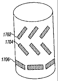
system suitable for data interpretation An example of tilted slots 1702, 1704,
1706 is
shown in Fig. 19a, An example of a tilted coil is shown in Fig. 19b. It should
also be
23
CA 02478157 2012-06-07
noted that instead of a slotted antenna cover, measurements may also be made
through a
substantially nonconductive antenna.
[0050] Returning now to Fig. 16, in an optional embodiment of the invention,
the measurements
are made using a wireline device. Hence, there is no altering of a drilling
direction. However,
completion of the wellbore is done 1526 based on the comparison and analysis,
or on the basis of
the estimated distance.
[0051] In addition to multicomponent measurements, the method of the present
invention may
also be used with multi-component, multi-array measurements made with a
plurality of
transmitter-receiver distances. A methodology for interpretation of
conventional multi-array
measurements is disclosed in US Patent 6,308,136 to Tabarovsky et al, having
the same assignee
as the present invention.
[0052] The method of the present invention may also be used with measurements
from other
types of resistivity tools, such as a propagation resistivity device.
[0053] Included in the present invention are certain operations that have been
used in prior art
with respect to conventional logging tools. One of these is the operation of
calibration wherein a
measured current or voltage is related to a conductivity (or resistivity)
using a relation of the
form
aHõ,,.+b
Another step that is necessary in the present invention is that of temperature
correction; this is
more important for a LWD application than for a wireline device wherein the
temperature has
had time to reach an equilibrium.
[0054] While the foregoing disclosure is directed to the preferred embodiments
of the invention,
various modifications will be apparent to those skilled in the art.
24