Note : Les descriptions sont présentées dans la langue officielle dans laquelle elles ont été soumises.
CA 02490119 2009-08-24
Method and driver information system for representing a selected map extract
The present invention relates to a method of representing a selected map
extract on a
display of a driver information system wherein a map background and at least
one map
information are represented in different colours or gray values, and to a
driver information
system for executing such a method.
For orientation in traffic, high-quality driver information systems are known,
which, for rep-
resenting street maps, are equipped with a colour TFT display as well as with
an external or
an integrated navigation system. The map extracts that can be represented are,
according
to requirements, selected map extracts in various views, e.g. for representing
a destination
area, for representing a calculated total route or for representing the
current vehicle posi-
tion. In response to selected user requirements, the map or the map extract
can be repre-
sented on an enlarged or on a reduced scale.
In contrast to printed street maps or city maps, the map extracts for driver
information sys-
tems are calculated from abstract map data of a data carrier in real time.
This has the effect
that the representation is produced from the smallest possible number of
primitive basic
elements and looks therefore very coarse. Independently of the scale used,
streets are rep-
resented as simple lines, the streets being provided with letterings along a
horizontal line or
a continuous tangent independently of the orientation and of the shape of the
street in ques-
tion. This course of action leads to map representations of driver information
systems which
look very simple and coarse in comparison with conventional maps. This has the
effect that
an excessive percentage of the driver's attention will be absorbed by the
interpretation of
the representation and that the driver will be unable to grasp the map
information intuitively.
It is the object of the present invention to improve a method of representing
a selected map
extract and a driver information system for executing such a method.
This object is achieved by a method for representing a selected map extract on
a display of
a driver information system wherein a map background and at least one map
information
are represented in different colours or gray values, characterized in that the
colour or gray
value of the map information and the colour or gray value of the map
background are
selected with respect to each other in an ergonomically adapted manner with
respect to the
optical effect produced. This object is also achieved by a driver information
system for
CA 02490119 2009-08-24
2
executing such a method, comprising a control unit, a display and a memory for
providing
and representing map-extract data. Advantageous further developments are
described
below.
Due to the fact that the map information and the map background are
represented such that
they are ergonomically adapted to one another, the representation of the map
information
will be improved. A representation that can be grasped intuitively is thus
especially possible,
and this will result in an improvement of the useful effect of the maps or of
the map extract
shown and in a reduction of the distraction potential for the driver looking
at the represented
map extract.
The map information that can be represented are especially roads/streets;
various types of
roads/streets, e.g. city streets, country roads and motorways, can be
distinguished. Infor-
mation provided in addition to the map information can, for example, be road
borders repre-
sented in a different colour so as to contrast the road with the depicted map
background or
so as to distinguish it from other types of roads with respect to its
significance. Other map
information or additional information can be street names or information on
motorways,
motorway service areas, places or objects of interest, directions and scales.
It will be expedient to adapt the colour of the map information, in particular
the road, to the
colour of the map background so that the road will be clearly visible on the
one hand, with-
out deviating excessively from the background colour on the other, so that the
contrast be-
tween the two colours will not be irritatingly strong. When gray values are
used, gray values
which correspond to the gray levels of the corresponding colour values can
especially be
chosen. In addition, a colouring which has been adapted with respect to colour
intensity can
be used for the additional items of information characterized by colours.
When the map background is represented in colour, it will be of advantage when
the dis-
tance between the colour of the map information and the colour of the map
background
does not exceed approx. 1200 on the hue circle so as to avoid excessively
strong colour
contrasts. In the case of a blue background, for example, the colour red or,
in the other di-
rection, the colour yellow would be 120 away. When colour coding is used, it
will be par-
ticularly advantageous to choose the colours of transition information, e.g.
the colour of a
road border in comparison with the colour of a road, between the colour of the
map infor-
mation and the colour of the map background. In so doing, the colour of the
additional in-
CA 02490119 2004-12-15
WO 03/107312 PCT/EP03/06262
3
formation or transition information should advantageously be kept closer to
the colour of the
map information than to the colour of the map background so that it will still
be possible to
discern that the additional information belongs to the map information.
An advantageous embodiment is so conceived that, starting from a selected
point or from
the colour of the map background, colours of primary map information of a type
of informa-
tion are chosen on the hue circle in one direction in a weighted or ordered
manner, e. g. in
the case of a differentiation between city street, country road and Federal
motorway. Also a
distribution to two different sides of the hue circle, starting again from a
selected point or
from the colour of the background, will be of advantage so as to emphasize
particularly im-
portant map information, e.g. motorways in comparison with other types of
roads, or e.g.
roads/streets in general in comparison with street names, information on
places and objects
of interest and the like.
It will be particularly advantageous when, depending on the selected scale,
thinner struc-
tures of a map information are represented in a comparatively more intensive
colour than
thicker structures so that, due to the objectively stronger colour or the more
striking hue, the
thinner structures will not get lost in comparison with the additional
information.
According to an advantageous embodiment, the strength of graphic
representation can also
be adapted in dependence upon the scale chosen; especially in the case of a
large scale a
great strength of graphic representation will be chosen, whereas in the case
of a small
scale a small strength of graphic representation will be chosen.
It is also possible to vary the colour intensity with respect to the hue or
the actual intensity in
dependence upon the respective scale. According to a particularly advantageous
embodi-
ment, the represented map information can also be smoothed so that roads will,
for exam-
ple, no longer be shown in an angular mode of representation but in a rounded
or smooth
mode in accordance with their natural course.
Letterings of map information are advantageously represented along the course
of the map
information in question, and a letterwise orientation will be particularly
expedient. For this
purpose, the individual letters are represented such that they are arranged
orthogonally to
the tangent of the respective map-information position.
CA 02490119 2004-12-15
WO 03/107312 PCT/EP03/06262
4
In the following, embodiments will be explained in detail making reference to
the drawing, in
which:
Fig. 1 shows schematically individual components of a driver information
system
which is coupled with a navigation system;
Fig. 2A,2C,2E show three conventional map representations;
Fig. 213,2D,2F show adapted map representations of various advantageous
embodiments;
Fig. 3A,36 show representations of a hue circle with different assignments
of the
colours to different items of map information, and
Fig. 4 shows a flow chart for describing the course of action adopted
for
representing a new map extract.
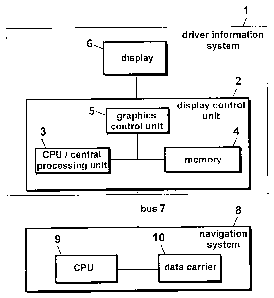
As can be seen from Fig. 1, a driver information system 1 consists of a number
of compo-
nents, in particular a display control unit 2 which normally comprises a
central
processing unit CPU 3, a memory 4 and a graphics control unit 5 for operating
a display 6.
The memory 4 has especially stored therein map data for representing map
extracts on the
display 6. In addition, the memory 4 contains information indicating in which
way various
map contents, i.e. especially a map background and map information, are to be
repre-
sented. The central processing unit 3 controls the operation of the whole
driver information
system 1. For supporting the display, i.e. for faster processing of the
special graphic data,
the graphics control unit 5 is used.
The driver information system 1 is connected to a navigation system 8 via a
bus 7; nor-
mally, also said navigation system 8 comprises a central processing unit CPU 9
and a data
carrier 10 or memory. The data carrier 10 typically comprises, on the one
hand, data which
can be used as basic data for representing a map and, on the other hand, also
data which
are adapted to be linked with data of a global positioning system (GPS) and,
optionally,
data of wheel positions, distance measuring equipment etc. of the associated
vehicle.
CA 02490119 2004-12-15
WO 03/107312 PCT/EP03/06262
For a high-quality ergonomic representation of map extracts, various forms of
representa-
tions, which will be explained hereinbelow, can be used individually or in
combination. In
particular, scale-dependent representations of the road width and of the road
borders can
be translated such that they can be grasped intuitively; this can be done by
scale-
dependent colour compensation, by antialiasing, i.e. smoothing, or by adapting
the map
information, especially roads, to the map background. In this connection, it
will be particu-
larly advantageous to use a scale-dependent colour compensation permitting a
colour rep-
resentation of a given class of roads or of a given type of roads which the
viewer of display
6 will subjectively feel to be uniform. Alternatively to or in addition to the
variation of the col-
our representation, various gray levels of the gray scale can be used as well.
If, for exam-
ple, a colouring which is subjectively felt to be uniform is to be represented
against a con-
trasting background for a thin structure, e.g. a stroke, and for a planar
structure, e.g. a thick
line, it will be important that the colour of the thin structure is
objectively much stronger.
Otherwise, the thin structure would seem, in direct comparison with the planar
structure,
much paler in the case of objectively identical colour values. Since the road
colour subjec-
tively felt by the viewer will be identified by the viewer with a
corresponding road class, the
colour impression of a road of a specific type of roads should be kept
constant over the
whole scale range independently of the road width so as to obtain an ergonomic
map rep-
resentation. For example, when represented on a large scale, a road should be
represented
thinly and in a strong colour, whereas in the case of a smaller scale of
enlargement the
same road will be represented more broadly and in a weaker colour.
In addition to a scale-dependent colour compensation, also a scale-dependent
representa-
tion of the road width will be particularly advantageous. From traditionally
printed maps, the
viewer is used to maps on which the width of the road shown depends not only
on the type
of road, e.g. by-roads in comparison with Federal roads or city streets in
comparison with
country roads, but also on the map scale. The larger the scale of a map, the
thicker the rep-
resentation of a given type of roads. Whereas on a city map on a scale of 1 :
1,000 a road is
represented e.g. with a stroke width of 1 mm, the same road will also be
represented with a
stroke width of 1 mm on a map on a scale of 1 : 5,000. In addition to the
possibility of con-
stantly maintaining the stroke width in the case of different scales for the
map extract en-
largement, it is also possible to use a relative change of the stroke width
for representing a
road with an increasing or decreasing scale of enlargement. For example, on a
map on a
scale of 1 : 1,000 the stroke width for a road may be 1 mm and in the case of
a larger scale
CA 02490119 2004-12-15
WO 03/107312 PCT/EP03/06262
6
of e.g. 1 : 5,000 it may only be 0.5 mm. It will be expedient to choose the
colour relation-
ships such that, when the scale of enlargement increases, the representation
of a map in-
formation, e.g. road, will become stronger relative thereto (Fig. 2F). When a
map function is
operated in the driver information system 1 with the aid of a zoom function,
the optically
effective road width is an important criterion of orientation for the viewer,
since the numeri-
cal scale displayed is often very small and not large enough for a cursory
glance while the
vehicle is in motion. It follows that, for an ergonomic map representation, it
will also be ex-
pedient to determine the road width in dependence upon the scale chosen und to
enlarge
the map extract; in so doing, the colour intensity should be adapted.
Such an enlargement can be seen e.g. from the comparison of Fig. 2A and 2B.
Various roads are shown against a uniform or a weakly structured map
background 20.
Whereas according to the representations normally used for driver information
systems 1 all
roads are represented as uniform stroke lines (Fig. 2A), certain roads, in the
present case
motorways 21, are represented by lines which are thicker than those that would
be admis-
sible in a representation with a correct scale ratio (Fig. 2B).
Especially, the map information, i.e. the motorways 21 shown, are additionally
provided with
road borders 22 which are depicted for making said motorways more easily
visible, as can
be seen from Fig. 2D. When such road borders 22 are represented, the viewer
will be more
easily able to discern intuitively the course of a road 21, since said road
borders 22 define a
kind of visual channel and prevent the viewer's eyes from wandering. This
stylistic element
is known per se from conventional printed map representations and can be
transferred in an
advantageous manner. It will also be of advantage to choose the nature and the
width of
the road borders in dependence upon the scale of the type of road. In the case
of certain
types of roads, e.g. motorways and Federal roads, road borders will also be of
advantage
in smaller-scale representations so that the roads in question can be detected
and distin-
guished more easily. As far as by-roads and city streets are concerned, such
road borders
are normally only used in the case of large scales.
As can be seen from the comparison of Fig. 2C and 2D, the readability of
roughly repre-
sented map information can also be improved by smoothing. Antialiasing, which
is known
per se, can be used for the purpose of smoothing. This can especially be
carried out by
CA 02490119 2004-12-15
WO 03/107312 PCT/EP03/06262
7
mixing the foreground and the background colours of the pixels located in the
transition
area from one colour to another colour. Disturbing stair-step artifacts can be
avoided or re-
duced in this way, said stair-step artifacts resulting from the normally
rectangular structure
of the pixels of a TFT display 6. The individual picture elements or pixels of
such TFT dis-
plays 6 have a discernible size so that an effective reduction of the stair-
step effect can be
achieved by suitable colour mixing or antialiasing. In the case of
conventional printed map
representations this effect is not visible due to the much higher possible
resolution, and
countermeasures are therefore not necessary.
Accordingly, the colour transitions between map information, e.g. roads 21,
and additional
information, e.g. road borders 22, are smoothed with the aid of antialiasing
so as to obtain
an ergonomic map representation of a map extract in the driver information
system 1. Tran-
sitions between the road borders and the map background can be smoothed as
well. It will
be of advantage to implement a hardware solution for such an antialiasing
function. Al-
though modern graphics control units 5 are already provided with a restricted
antialiasing
function, whereby the central processing unit 3 is relieved effectively, the
expenditure of
time for map calculation is, though reduced, still too high.
It will also be of advantage to adapt the colour of road borders to the
background of the
map. For reasons of efficiency, the hardware antialiasing provided by graphics
control units
is not optimal, since mixing between foreground and background colours takes
place only in
a small number of steps. This has the effect that transitions between colours
forming a
strong contrast, e.g. complementary colours, cannot be dealt with
satisfactorily and that
stair-step artifacts are still visible in spite of hardware antialiasing.
Hence, transitions of re-
lated colours should be smoothed for achieving representations of higher
ergonomic quality.
For this purpose, it will be advantageous to adapt the colour of the
additional information
22, i.e. of the road borders by way of example, to the map background 20 on
the one hand
and to the map information 21, i.e. the road by way of example, on the other
hand. A bor-
dered road 21, i.e. a road 21 with road borders 22, has two colour transitions
on either side.
The first colour transition takes place between the road 21 and the road
border 22, the
second colour transition takes place between the road border and the map
background 20.
When choosing the colour, the colour of the additional information, i.e. of
the road border
22, will therefore be chosen such that a strong contrast will exist neither
between said col-
CA 02490119 2004-12-15
WO 03/107312 PCT/EP03/06262
8
our of the additional information and the colour of the map information, i.e.
the road 21, nor
between said colour of the additional information and the colour of the map
background 20.
Normally, it will also be advantageous to adapt the lettering 27 to the road
course, as can
be seen e.g. from Fig. 2D. Road letterings, which are unequivocally assigned
to the associ-
ated road, are particularly suitable for an ergonomic map representation.
Since roads nor-
mally have irregular curve shapes, a lettering will be preferred which
deviates from the nor-
mally used straight tangential or Cartesian lettering. Instead, each letter of
the lettering is
arranged along the road course. Simultaneously, each letter is oriented
orthogonally to the
tangent of its point of contact with the road 25. When, in the case of a large
scale, the road
width is sufficiently large, the lettering may selectively also be provided on
top of the repre-
sentation of the road instead of by the side of the road.
In addition to the representation of various items of map information in the
form of roads,
such as motorways 21, 22, country roads 23, 24 and city streets 25, 26¨ a
sketch of said
representations being shown in Fig. 2A to 2F ¨ street names 27, information
symbols 28
for petrol stations, motorway exits and the like as well as basic map
information 29, such as
a scale or a directional arrow, are shown as additional information.
A first embodiment of a colour selection is shown in Fig. 3A on the basis of a
hue circle in
which the colour spectrum is divided in a 0 to 360 range. In this embodiment
the back-
ground is associated with colour position 0 . The 0 position should in this
case correspond
e.g. to the colour yellow. Accordingly, the colour red would be located at 120
and the col-
our blue at 240 .
In the example shown in Fig. 3A, a colour which is clearly different from the
colour of the
other roads and also from the background, should be chosen for the motorways
21. In the
present case, the motorways BAB/21 have associated therewith the colour red-
orange,
which would be located at 90 . For the road borders the graded orange colours
at 70 and
75 are used, which lie between the colour for the background and the colour
for the
motorways. Since the borders have to be regarded as part of the motorway, the
distance
will be chosen closer to the colour for the motorway than to the colour for
the background.
CA 02490119 2004-12-15
WO 03/107312 PCT/EP03/06262
9
Starting from the background colour at 00, the colours for the additional
roads are located at
the other side of the hue circle. These colours are e.g. a green hue at 300
for country
roads 23, a green-yellow hue at 330 for the borders of the country roads as
well as the
colour blue-green at 260 for city streets. The colour blue at 240 is
assigned to additional
information symbols 28, i.e. to the petrol station symbols by way of example.
Such addi-
tional symbols 28 and also basic map information symbols 29 may, for example,
also be
depicted in a mere black-white representation.
Fig. 3B shows an embodiment in which, starting from the background colour at
00, which is
e.g. yellow, the colours for the various types of roads are distributed over a
colour spectrum
range of up to 120 . The city streets may e.g. have assigned thereto the
colour at 60 , the
country roads the colour at 90 and the motorways the colour at 120 . For the
additional
symbols and street names, colours of preferably another sector of the hue
circle can again
be chosen, unless these additional symbols and street names are given the
colours of the
associated streets.
Whereas in the first depicted embodiment according to Fig. 3A, the colours for
the various
roads 21-26 are distributed over a spectral range which is slightly larger
than 120 , the col-
ours of the second embodiment do not exceed a preferred spectral range of 120
.
In the colour assignments shown, a respective discrete colour has been
assigned to an item
of map information, i.e. a road 21 in the present case, and another discrete
colour has been
assigned to an item of additional information, i.e. the road border 22 in the
present case. It
is, however, also possible to assign a plurality of colours within a
preferably narrow spectral
range so that the colour contrast can be reduced over a plurality of colour
steps.
On the basis of the flow chart according to Fig. 4, an exemplary method of
controlling the
construction of a map extract is shown. In a first step S1, the program is
started, e.g. for
representing a new map extract, since a concrete user requirement or a change
in the posi-
tion of the vehicle has been registered. In the following step S2, it is
examined whether all
the necessary map data for this map extract are available in the display
control unit 2. If not,
data will be requested from the memory 4 and/or from the data carrier 10 in
the navigation
system 8 in a further step S3. This is followed by a return to the preceding
inquiry step S2.
When all data are available, the representation of the requested map extract
is started with
CA 02490119 2004-12-15
WO 03/107312 PCT/EP03/06262
the background in a step S4. In the following step S5, it is examined whether
or not all the
roads 22-26 of the requested map extract have been represented. If this is the
case, the
lettering is added in a step S12, whereupon the map extract is represented on
the display 6
in a final step S13.
If additional roads have to be represented, the sequence of method steps
proceeds from
step S5 to a step S6 in which the next road to be represented is determined.
For this pur-
pose, an examination on the basis of the above-indicated criteria is first
carried out in step
S7, e.g. an examination as to whether the road 21, 23 is to be provided with a
road border
22, 24 which has to be represented. If this is the case, the parameters for
the road border
22, 24, i.e. the road border width and the road border colour, are determined
in a following
step S8, before the road border is represented in a step S9. After the
representation of the
road border in step S9 or in the negative case of the inquiry step S7, the
parameters for the
representation of the associated roads 21, 23 are determined in a step S10.
After the repre-
sentation of the road in step S11, a return to step S5 takes place once more;
in step S5, it is
examined once more whether additional roads are to be represented.
When the roads have been lettered, a further step for representing additional
items of in-
formation can optionally be incorporated into the sequence of method steps as
a final step;
such additional items of information can be a scale, a directional arrow or
symbols referring
to traffic points of importance or to places or objects of interest.
For reasons of representation, hatched and dotted graphic elements have been
used in-
stead of colour values and gray values have been used substitutionally for
various colours
in Fig. 2A-2F. In this way, the viewer will see a kind of gray scale which,
like a genuine gray
value scale and a colour scale, can be chosen as a possible form of
representation for map
extracts.