Note : Les descriptions sont présentées dans la langue officielle dans laquelle elles ont été soumises.
CA 02494490 2005-01-26
Docket No. 1010-0005-CAN
TITLE OF THE INVENTION
[0001] Controlling Solution Latency in a Global Navigation Satellite Receiver
BACKGROUND OF THE INVENTION
[0002] This invention relates generally to satellite navigation systems, and
more particularly to controlling solution latency in a satellite navigation
system.
[0003] Global Navigation Satellite Systems (GNSS) are well known and used to
solve a wide variety of positioning/time related tasks. Two well known such
systems are
the Global Positioning System (GPS) of the United States and the GLObal
NAvigation
Satellite System (GLONASS) of Russia. This description will generally refer to
the GPS
system, but it is to be understood that the present description is equally
applicable to
GLONASS or other GNSS systems.
[0004] In recent years, there have been significant developments in the use of
GPS receivers in the surveying and construction industries. In surveying
applications,
GPS is generally used to determine locations of points on the ground. GPS
receivers
are also being used for machine control in which the GPS position information
is used to
control construction machines. For example, GPS positioning information may be
used
to dynamically control a bulldozer blade. The use of GPS positioning in
surveying and
machine control provides many benefits, including responsiveness, reliability,
autonomy, and all-weather operation.
[0005] The accuracy of GPS positioning has been improved by integrating
other sources of positioning information with the GPS positioning receiver.
These other
sources provide additional positioning information which allows for a more
accurate
positioning solution. One example of such integration is in aviation, where it
is common
to integrate inertial sensors with GPS receivers. One reason for such
integration is that
inertial sensors have small short-term error and large long-term error, while
GPS
receivers have large short-term error and small long-term error. The
integration of
inertial sensors with GPS receivers provides a complement and allows a
combined
device to reduce both short-term and long-term errors. This improves the
accuracy of
positioning determination.
Page 1 of 16
CA 02494490 2005-01-26
Docket No. 1010-0005-CAN
[0006] Typical examples of inertial sensors are accelerometers and gyros.
Accelerometers measure acceleration and gyros measure angular rate. One
typical
integration technique is to provide an Inertial Measurement Unit (IMU)
consisting of
three accelerometers and three gyros. Sensors in each triad are orientated in
mutually
perpendicular directions. The sensor signals are digitized using an Analog to
Digital
Converter (ADC) and provided to the GPS receiver where they are combined with
the
GPS data.
[0007] An important requirement of an integrated IMU/GPS system is time
synchronization of the GPS and IMU data. In other words, the data that is
generated by
each of the systems should have the same time reference point. Otherwise, the
benefits of integrating the two systems will be reduced because there will be
a reduction
in accuracy of the ultimate positioning result obtained. In an IMU of the type
described
above, synchronization is generally accomplished as follows. The GPS receiver
calculates position information at periodic time moments, referred to herein
as epochs,
which are defined by a local clock signal within the GPS receiver. The local
clock signal
is formed using a high quality quartz generator. The GPS receiver outputs this
local
clock signal to the IMU. The IMU outputs its data to the receiver in response
to the local
clock signal. The IMU and GPS are synchronized by controlling the timing of
the IMU's
data generation by the GPS clock signal.
[0008] There are sources of positioning and geometric information which are
not so easily synchronized. For example, there exist devices which provide
positioning/geometric information where the precise moment of data generation
cannot
be controlled via a GPS clock signal. One such device is a rotating laser
system which
may be used to determine additional positioning/geometric information. Such a
system
is described in detail in U.S. Patent Application Publication No. US
2004/0125365 Al
published July 1, 2004, entitled Working Position Measuring System. Such a
rotating
laser system generally includes a rotating laser at a fixed location, with a
photodetector
co-located with the GPS receiver. The photodetector periodically detects the
rotating
laser beam and generates a signal based upon receipt of the laser (i.e., when
the laser
beam strikes a photocell of the detector). The signal may be processed using
various
Page 2of16
CA 02494490 2005-01-26
Docket No. 1010-0005-CAN
techniques in order to provide additional positioning/geometric information,
such as the
elevation angle between the photodetector and the transmitter. Knowledge of
the
elevation angle allows calculation of the height difference between
transmitter and
photodetector by multiplying the tangent of the angle and distance. Distance
is
calculated by the GPS receiver which is integrated in one housing with the
laser
detector. The accuracy of height estimation is improved because the elevation
angle
measurement is very precise within a small range. Such techniques are
described fully
in the above referenced U.S. Patent Application Publication No. US
2004/0125365 Al.
The details of such techniques are not important for the present discussion.
What is
important to recognize is that the data generation of the photodetector may
not be
synchronized with the GPS system by providing the GPS clock signal to the
photodetector. The timing of the data generation of the photodetector is
dependent
upon the moment in time that the laser beam strikes the photocell of the
photodetector.
Such time is dependent upon the angular velocity of the rotating laser
transmitter (and
dependent upon dynamics (e.g., movement, if any) of the photodetector) and
cannot be
controlled by a clock signal received by the photodetector.
[0009] The above described synchronization problem results in a degradation
of the position calculation. At the epoch moment when the GPS position
calculation is
made, the elevation angle data available from the photodetector is from some
point in
time prior to the epoch moment. The elevation angle is likely to have changed
since
this prior point in time, and thus the use of the old elevation angle data
inserts error into
the position calculation. Thus, stated another way, there is a latency between
the time
the elevation angle is calculated and the time when such elevation angle is
actually
used in conjunction with the GPS data to determine position. This solution
latency
results in reduced positioning accuracy.
[0010] One known solution to this problem is to extrapolate the elevation
angle
data to estimate the elevation angle at the epoch moment when the positioning
determination is made. While this is an improvement over using the earlier
calculated
elevation angle, there is still a significant extrapolation error which
reduces the accuracy
of the position determination. In dynamic machine control applications, such
as
Page 3 of 16
CA 02494490 2010-05-05
bulldozer blade control, such reduced accuracy has a significant effect on the
overall
effectiveness of the system.
[0011] While the solution latency problem has been described in connection
with a rotating laser system which computes elevation angle, one of ordinary
skill in
the art will recognize that the latency problem exists anytime a non-satellite
source of
positioning information is integrated with a GPS system where the non-
satellite
source cannot be readily synchronized using a clock signal from the GPS
receiver.
[0012] Thus, there exists a need to solve the solution latency problem
described above.
BRIEF SUMMARY OF THE INVENTION
[0013] The present invention provides a method and apparatus for solving the
solution latency problem.
[0013a] Certain exemplary embodiments can provide a method for
synchronizing a satellite positioning device having a local clock defining an
epoch
period with a laser beam signal comprising the steps of: a) receiving said
laser beam
signal at a first time; b) calculating a clock correction based at least in
part on said
first time; c) applying said clock correction to the local clock of the
satellite positioning
device.
[0013b] Certain exemplary embodiments can provide a satellite positioning
device comprising: a local clock; a satellite signal processor for processing
satellite
signals and generating position information, whereby timing epochs of said
processing are based on said local clock; a laser signal processor for
processing
received laser beam signals; and a time difference module for generating a
clock
correction signal based at least in part on the time of receipt of said laser
beam
signals.
[0013c] Certain exemplary embodiments can provide a method for use in a
satellite positioning device which generates final position information based
on
received satellite signals and at least one received non-satellite signal,
said method
Page 4 of 16
CA 02494490 2010-05-05
comprising the steps of: periodically calculating satellite position
information at
each of a plurality of epochs, said epochs defined by a local clock;
periodically
calculating non-satellite position information based on said non-satellite
signal at
each of a plurality of event times, said event times defined by time of
receipt of said
non-satellite signals; periodically calculating final position information
based on said
satellite position information and said non-satellite position information;
and applying
clock corrections to said local clock to improve the synchronization of said
epochs
and said event times.
[0013d] Certain exemplary embodiments can provide a satellite positioning
device comprising: a local clock /defining an epoch period; means for
receiving a
laser beam signal generated by a rotating laser transmitter at a first time;
means for
calculating a clock correction based at least in part on said first time; and
means for
applying said clock correction to the local clock.
[0014] Other embodiments can provide a method and an apparatus for
synchronizing a satellite positioning device having a local clock with a
signal received
from a non-satellite device. The local clock of the satellite positioning
device controls
the epoch periods of the device. A clock correction is calculated based at
least in
part upon the time of receipt of the non-satellite signal. The calculated
clock
correction is then applied to the local clock in order to better synchronize
the epoch
time and the time of receipt of the non-satellite signals. The clock
correction may be
calculated each time the non-satellite signal is received.
[0015] In one advantageous embodiment, the non-satellite signal is generated
by a rotating laser transmitter.
[0016] These and other advantages of the invention will be apparent to those
of ordinary skill in the art by reference to the following detailed
description and the
accompanying drawings.
Page 4a of 16
CA 02494490 2005-01-26
Docket No. 1010-0005-CAN
BRIEF DESCRIPTION OF THE DRAWINGS
[0017] Fig. 1 shows a system in which the present invention has advantageous
applicability;
[0018] Fig. 2 shows another system in which the present invention has
advantageous applicability;
[0019] Fig. 3 illustrates a synchronization problem and shows two
asynchronous time scales;
[0020] Fig. 4 illustrates extrapolation of an elevation angle;
[0021] Fig. 5 shows a high level block diagram of a device configured in
accordance with one embodiment of the invention; and
[0022] Fig. 6 is a flow diagram showing the steps performed during operation
of
the apparatus shown in Fig. 5.
DETAILED DESCRIPTION
[0023] One system in which the present invention has advantageous
applicability is shown in Fig. 1. The system comprises a rotary laser device
27 for
projecting a fan-shaped beam by rotary irradiation and a photodetection sensor
device
28 for receiving the fan-shaped beam.
[0024] A tripod 29 is installed so that the tripod is approximately aligned
with a
known point X, and the rotary laser device 27 is mounted on the tripod 29. The
rotary
laser device 27 comprises a main unit 31 and a rotator 32 rotatably mounted on
the
main unit 31. A laser beam 33 is projected by rotary irradiation from the
rotator 32. The
photodetection sensor device 28 is supported by a predetermined supporting
means.
Fig. 1 shows how the device is operated in field operation. The photodetection
sensor
device 28 is installed on a rod 34, which can be manually carried by an
operator. On an
upper end of the rod 34, there is provided a GPS position measuring device 30.
By
using the GPS position measuring device 30, an absolute position on the ground
can be
measured based on a signal from a navigation satellite.
Page 5 of 16
CA 02494490 2005-01-26
Docket No. 1010-0005-CAN
[0025] The laser beam 33 comprises a plurality of fan-shaped laser beams 33a
and 33b in a vertical direction and a fan-shaped beam 33c tilted diagonally
with respect
to the fan-shaped beams 33a and 33b at an angle of 0 , forming an N-shaped
configuration. Also, the laser beams 33a and 33b are projected in a direction
of 6 with
a spreading angle a respectively.
[0026] Another system in which the present invention has advantageous
applicability is shown in Fig. 2. In Fig. 2 the photodetector device 28 is
fixed on a
working tool of a construction machine (e.g., on a blade 18 of a bulldozer
17). A
mounting pole 19 is erected on the blade 18, and the photodetection sensor
device 28
is mounted on the mounting pole 19, and a GPS position measuring device 30 is
installed at an upper end of the mounting pole 19. The bulldozer 17 comprises
an
excavation operation control unit (not shown) such as a computer to control
the
operation of the blade 19.
[0027] In both the systems of Figs. 1 and 2, the photodetection sensor device
comprises a photodetection unit for receiving the fan-shaped beams and an
arithmetic
unit for calculating an elevation angle relative to the rotary laser device
based on
photodetection signals produced when the photodetection unit receives the
light beam.
The elevation angle produced by the photodetection sensor device may be used
in
conjunction with the GPS position measuring device to increase the accuracy of
the
position determination task.
[0028] Further details of the functioning of a rotating laser system of the
type
described herein in conjunction with Figs. 1 and 2 may be found in United
States Patent
Application Publication No. US 2004/0125365 Al, published July 1, 2004,
entitled
Working Position Measuring System. Such details will not be described in
further detail
herein as such details are not necessary for an understanding of the present
invention.
[0029] As described above in the background of the invention, one of the
problems presented when incorporating information from a non-satellite source
of
position/geometric information is the solution latency problem. This problem
will now be
described in further detail in conjunction with Fig. 3, which illustrates the
synchronization
problem discussed above.
Page 6 of 16
CA 02494490 2005-01-26
Docket No. 1010-0005 -CAN
[0030] Fig. 3 shows two asynchronous time scales. The solid line signal
pulses, e.g., signal pulse 102, represent the accurate equidistant signal
pulses
generated by the local clock of the GPS receiver. These are the pulses that
define the
epoch moments of the GPS receiver. The broken line signal pulses, e.g., signal
pulse
104, represent the moments that the laser beam is detected by the
photodetector
device and the elevation angle is computed. These pulses are also referred to
herein
as event pulses. In Fig. 3, it is assumed that the period of the rotating
laser is close to
the period of the GPS local clock pulses. The delay (solution latency) is
represented in
Fig. 3 by 106, which represents the time delay from the calculation of the
elevation
angle (at time pulse 104) to GPS epoch moment 102. It is at time 102, when the
GPS
unit calculates the GPS position, that the elevation angle can be used to
improve the
position determination. However, at time 102 the elevation angle calculated at
time 104
is an old measurement (delayed by interval 106). It is noted that due to the
nature of
the time scales, the delays (latencies) of a last event pulse relative to a
current epoch
pulse are continuously varying from 0 to the period of event pulses.
(0031] In prior art systems, the latency problem is handled by extrapolation
of
the laser elevation angle to the current epoch moment. This extrapolation
technique is
illustrated in Fig. 4. In Fig. 4 line 130 represents the actual elevation
angle over time of
the mobile unit. The varying elevation angle may be the result, for example,
of the
photodetection device being mounted on construction equipment as shown in Fig.
2.
Broken vertical lines 402a, 402b, 402c and 402d represent the event pulses
(104 in Fig.
3) and are the times that the rotating laser beam strikes the photodetector
device.
Thus, accurate elevation angles are computed as follows. At event pulse 402a
elevation angle 404a is computed, at event pulse 402b elevation angle 404b is
computed, at event pulse 402c elevation angle 404c is computed, and at event
pulse
402d elevation angle 404d is computed. Time 137 represents a GPS epoch moment,
controlled by the local clock of the GPS unit, at which time a GPS position
calculation is
made. As discussed above, it is desirable to augment the GPS position
calculation with
the elevation angle information. However, at time 137 the most recent
elevation angle
information 404c was calculated at time 402c. There is a latency as
represented by
Page 7 of 16
CA 02494490 2005-01-26
Docket No. 1010-0005-CAN
120. One method of reducing the latency error is to extrapolate the elevation
angle
calculations to time 137. Such extrapolation requires a mathematical model of
the
change in elevation angle. A polynomial model is generally used for such
extrapolation,
as illustrated in Fig. 4 as the parabolic extrapolation 140 over the three
points 404a,
404b and 404c. However, since the actual change in elevation angle is random,
this
algebraic model is not effective and extrapolation error 150 results. This
extrapolation
error decreases the effectiveness of the integration of the elevation angle
data with GPS
position data.
[0032] The present invention reduces the extrapolation error by better
synchronizing the generation of the GPS position data with the generation of
the
elevation angle data.
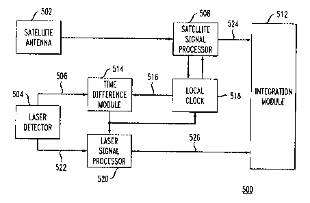
[0033] Fig. 5 shows a high level block diagram of a device 500 configured in
accordance with one embodiment of the invention. It is noted that this block
diagram is
meant to describe the high level functioning and configuration of device 500.
One
skilled in the art would readily recognize that some of the blocks represent
hardware
components while other blocks represent some function or operation. The
functions
and operations may be performed by hardware circuits, software instructions
executing
on a processor, firmware, or some combination of hardware and software. Given
the
description herein, those skilled in the art would be able to implement the
described
functionality using well known and various combinations of hardware and
software. As
such, implementation details of the functions described herein will not be
described in
detail as such implementation details would be readily known to one skilled in
the art.
[0034] The device 500 comprises a satellite antenna 502 which receives
satellite signals and provides the satellite signals to a satellite signal
processor 508.
The satellite signal processor 508 processes the satellite signals, calculates
GPS
position, and controls the local clock 518 as will be described in further
detail below.
The local clock 518 generates the epoch signal and local time which is used
for
processing the GPS signals in the satellite signal processor.
[0035] The device 500 also comprises a laser detector 504 which detects the
rotating laser beam and provides signals representative of the received laser
beam to a
Page 8 of 16
CA 02494490 2005-01-26
Docket No. 1010-0005-CAN
laser signal processor 520. The laser signal processor 520 processes the
signal
received from laser detector 504 in order to extrapolate an elevation angle as
described
above.
[0036] The laser detector 504 outputs an event signal 506 which, as described
above, is the timing signal indicating the time at which the laser beam was
received by
the laser detector 504. This event signal 506 is provided to a time difference
module
514. Time difference module 514 also receives the epoch signal 516 from local
clock
518. The time difference module 514 calculates a clock correction based on the
received signals and the clock correction is applied to the local clock 518 in
order to
better synchronize the GPS epoch signal and the laser detector event signal.
This
improved synchronization results in a reduced extrapolation error.
[0037] Further details of the operation of the apparatus shown in Fig. 5 will
now
be described with reference to the flow diagram of Fig. 6. One skilled in the
art will
recognize that the steps shown in Fig. 6 and described herein may be
implemented
using various hardware and software configurations. For example, in one
embodiment,
the steps may be performed by one or more processors executing computer
program
instructions.
[0038] The processing of the steps shown in Fig. 6 are initiated upon the
receipt of an event signal from the laser detector 504 indicating that it has
received the
laser beam signal, as represented by 601. In step 602, the local time t is
determined.
The local clock 518 contains a local quartz oscillator that is used to keep
track of local
time based on counting. Next, in step 604, the time of the event signal, or
event time
(Tevent) is determined with reference to local time t. In step 606 the offset
(Toffset)
between GPS time and local time t is calculated. GPS time is the time scale of
the
satellite system which is controlled by an atomic clock onboard the satellite.
The offset
between GPS time and local time is calculated as a result of processing the
satellite
signals in the satellite signal processor 508. This calculation is based on
processing the
pseudoranges from at least four satellites and is a well known GNSS technique.
[0039] Next, in step 608 it is determined whether the Toffset calculated in
step
606 is greater than zero. If it is, then in step 610 one half of an epoch
period (Tepoch) is
Page 9 of 16
CA 02494490 2005-01-26
Docket No. 1010-0005-CAN
added to Tottset. If the Toffset calculated in step 606 is not greater than
zero, then one half
of an epoch period (Tepoth) is subtracted from Toffset in step 612. This
technique of
adding or subtracting one half of an epoch interval proves a zero mean value
of time
offset between GPS time and local clock time. After step 610 or 612, the local
clock
correction is calculated in step 614 by the following equation:
moTeveõ~ To~.er
T1.1 - 'epoch - d T 'epoch x int 7,
epoch epoch
[0040] The correction Tcorr calculated in step 614 is applied to the local
clock
518 to adjust the local time in step 616. The steps shown in Fig. 6 are
repeated each
time an event signal 506 is received from the laser detector 504 indicating
that the laser
detector 504 has received the laser beam signal. While other various
embodiments are
possible, in one embodiment of the invention, step 606 is performed by the
satellite
signal processor 508 and the remaining steps are performed by the time
difference
module 514 and the local clock 518.
[0041] The method described in conjunction with Fig. 6 results in the local
clock
518 being adjusted so that the event time and the epoch time are more closely
synchronized. As a result, the elevation angle data 522 provided from the
laser detector
504 to the laser signal processor 520 is the elevation angle data of a time
moment very
close to the time moment that the satellite signal processor 508 calculates
the GPS
position. This results in a smaller extrapolation error in the calculation of
the elevation
angle by laser signal processor 520. The GPS position 524 and the elevation
angle 526
are provided to the integration module 512. Since the GPS position and the
elevation
angle were substantially synchronously determined, the resulting position
determination
which uses both pieces of data is more accurate than in prior art solutions.
[0042] The foregoing Detailed Description is to be understood as being in
every
respect illustrative and exemplary, but not restrictive, and the scope of the
invention
disclosed herein is not to be determined from the Detailed Description, but
rather from
the claims as interpreted according to the full breadth permitted by the
patent laws. It is
Page 10of16
CA 02494490 2005-01-26
Docket No. 1010-0005-CAN
to be understood that the embodiments shown and described herein are only
illustrative
of the principles of the present invention and that various modifications may
be
implemented by those skilled in the art without departing from the scope and
spirit of the
invention. For example, while the embodiments described above have generally
been
focused on an implementation in which the non-satellite signal being used to
augment
the GPS data is from a rotating N-shaped laser, the non-satellite signal may
be any type
of signal which may be used in combination with the GPS data to augment the
position
determination.
Page 11 of 16