Note : Les descriptions sont présentées dans la langue officielle dans laquelle elles ont été soumises.
CA 02569494 2006-11-30
Docket No. 1010-0013-CAN
TITLE OF THE INVENTION
Virtual Profilograph for Road Surface Quality Assessment
BACKGROUND OF THE INVENTION
[0001] The present invention relates generally to machines for road paving
operations and, more particularly, to assessing the quality of a paved road
surface using
Global Navigation Satellite Systems.
[0002] Methods of designing and paving/surfacing streets, highways and
other such
roadways, and the equipment used in such paving operations, are extremely well
known. For example, in one such method, an asphalt mixture is spread on a
properly
graded and prepared surface and the mixture is then compacted using, for
example, an
asphalt compactor. The terms asphalt compactor, roller and roller machine are
used
interchangeably herein. One skilled in the art will recognize that there are
many
different types of paving/surfacing operations suitable for different
circumstances.
[0003] One key assessment of finished roadways is the quality of ride that
is
experienced by a vehicle as it passes over the roadway. Profilographs, which
are well-
known in the art, are typically used after construction of a roadway is
completed as one
method of measuring ride quality. A profilograph is a measurement device that
is
passed over a roadway to detect the presence and severity of bumps and dips in
order
to generate a longitudinal profile of the roadway. FIG. 1 shows a prior art
profilograph
100 useful for this purpose. Referring to that figure, profilograph 100 has a
frame 102
which is, for example, a lightweight aluminum frame. Exemplary profilograph
100 has a
length L of 25 feet. Frame 102 is supported above roadway 109 by wheel
assemblies
Page 1
CA 02569494 2006-11-30
Docket No. 1010-0013-CAN
101 and is adapted to be towed behind a vehicle in direction 110. Measurement
wheel
108 is attached to arm 107 which, in turn, is attached to mounting box 104
mounted to
frame 102 in a way that permits arm 107 and, hence, wheel 108, to move
vertically to
follow the contour of road 109 as the wheel passes over the road. Measurement
wheel
and/or arm 107 is connected to recording device 103 via cable 106 and flexible
shaft
105. As wheel 108 moves up and down vertically, i.e. over bumps and into dips
in a
roadway as the profilograph is towed, cable 106 shortens and lengthens,
respectively
and flexible shaft 105 rotates in relationship to the rotation of wheel 108.
Recording
device 103 records the variations in the length of cable 106 as a function of
the rotation
of wheel 108 and compares the vertical position of wheel 108 to the known,
fixed
position of wheel assemblies 101. Since the number of rotations of wheel 108
are
directly proportional to the distance traveled by the profilograph, recording
device 103
can accurately record the relative position of wheel 108 with respect to the
wheel
assemblies 101 in order to determine any fast elevation changes within the
length of the
profilograph 100 that may function to degrade ride quality. These elevation
changes
experienced along roadway 109 can then be plotted as a function of the
distance from a
starting point of the profilograph in order to generate a longitudinal profile
of that
roadway. Recording device 103 may be an analog device with a physical pen
connected to cable 106. In such a case, the pen moves proportionately with the
change
in length of cable 106 and records the dips and bumps on a roll of paper that
is scrolled
relative to the pen at a speed proportional to the rotational velocity of
wheel 108.
Alternatively, recording device 103 may be a digital computing device that
records
roadway profile information in digital memory. In either case, the result is a
profile or
Page 2
CA 02569494 2006-11-30
Docket No. 1010-0013-CAN
graph of a roadway showing any fast elevation changes as a function of
distance
traveled which can effect the ride quality of a vehicle passing over that
roadway.
[0004] Other variations on profilographs have also been used. For example,
profilographs that are shorter in length have been developed that are useful
at higher
speeds than the profilograph of FIG. 1, which is limited to relatively slow
speeds.
Additionally, laser ranging devices have also been used in profilographs,
herein referred
to as laser profilographs. Laser profilographs typically consist of one or
more laser
devices attached to a vehicle. The laser is pointed at the roadway as the
vehicle moves
and one or more sensors measure, for example, the time the light energy
emitted from
the laser takes to travel from the laser device to the sensor, thus allowing a
measurement of the distance from the laser to the ground. The longer the light
energy
takes to travel from the laser device, be reflected by the road and reach the
sensor, the
greater the distance above the ground the laser device/sensor are located. The
speed
of the vehicle is recorded while the distance measurements are taken and this
information is transmitted to a computer, which records the information in
order to
create a profile of the roadway.
BRIEF SUMMARY OF THE INVENTION
[0005] While prior profilographs were advantageous in many aspects, they
were also
limited in certain regards. For example, all prior profilographs required
careful
calibration prior to operation in order to obtain accurate results. Also,
typically, such
measurements only took place after a roadway was completed and usually were
accomplished by a different crew of workers than the crew that paved the
roadway, thus
Page 3
CA 02569494 2011-11-28
increasing the cost and time associated with completing the construction of a
roadway. Additionally, maneuvering such a large mechanical device as a prior
profilograph was difficult and unwieldy.
[0006]
Therefore, the present inventor has recognized there is a need for a more
efficient and timely method of measuring the ride quality of a roadway.
Accordingly,
the present invention is a graphical virtual profilograph that can provide
measurements indicative of the ride quality of a roadway as the road is being
constructed. As a result, a more timely, less costly indication of the ride
quality of a
roadway is obtained as compared to prior methods. In one embodiment, a
profilograph in accordance with the principles of the present invention allows
a road
construction crew to alter road construction in real time to improve the ride
quality of
the road.
[0006a] Certain exemplary embodiments can provide a method for use with a
first
vehicle adapted to move across a surface, said first vehicle comprising a
Global
Navigation Satellite System (GNSS) antenna receiver, said method comprising:
calculating a plurality of locations of said GNSS antenna at a corresponding
plurality
of different times, each of the plurality of locations having an elevation;
storing said
plurality of locations; generating a representation of said surface based on
said
plurality of locations and said corresponding plurality of times, the
representation
depicting a presence and severity of bumps and dips in said surface based on
the
elevation; and determining the ride quality of a second vehicle across said
surface
as a function of said representation based on the presence and severity of
bumps
and dips in said surface.
Page 4
CA 02569494 2012-10-23
[0006b] Certain exemplary embodiments can provide an apparatus for use with a
first vehicle adapted to move across a surface, said first vehicle comprising
a Global
Navigation Satellite System (GNSS) antenna, said apparatus comprising: means
for
calculating a plurality of locations of said GNSS antenna at a corresponding
plurality
of different times, each of the plurality of locations having an elevation;
means for
storing said plurality of locations of said antenna; means for creating a
representation
of said surface based on said plurality of locations and said corresponding
plurality of
times, the representation depicting a presence and severity of bumps and dips
in said
surface based on the elevation; and means for determining the ride quality of
a
second vehicle across said surface as a function of said representation based
on the
presence and severity of bumps and dips in said surface.
[0006c] Certain exemplary embodiments can provide a computer readable
medium storing computer program instructions which, when executed on a
processor, causes the processor to execute the following steps: calculating a
plurality
of locations of a Global Navigation Satellite System (GNSS) antenna at a
corresponding plurality of different times, each of the plurality of locations
having an
elevation, said GNSS antenna mounted on a first vehicle adapted to move across
a
surface; storing said plurality of locations of said antenna; creating a
representation
of said surface by displaying said plurality of locations as a function of
said
corresponding plurality of times, the representation depicting a presence and
severity
of bumps and dips in said surface based on the elevation; and determining the
ride
quality of a second vehicle across said surface as a function of said
representation
based on the presence and severity of bumps and dips in said surface.
Page 4a
CA 02569494 2011-11-28
[0006d] Certain exemplary embodiments can provide a virtual profilograph
comprising: at least a first GNSS antenna/receiver adapted to be attached to a
construction vehicle capable of moving on a surface; and a processor for
determining and storing a plurality of locations of said at least a first GNSS
antenna
at a corresponding plurality of times, each of the plurality of locations
having an
elevation, said processor adapted to create a representation of said surface
as a
function of said plurality of locations and said corresponding plurality of
times, the
representation depicting a presence and severity of bumps and dips in said
surface
based on the elevation, said processor adapted to determine the ride quality
of a
second vehicle across said surface as a function of said representation based
on
the presence and severity of bumps and dips in said surface.
[0007] In a first embodiment one or more Global Navigation Satellite System
antennae are attached to a vehicle. When the vehicle travels over a roadway,
measurements of the position of the antenna are recorded at different times. A
profile of the roadway is created by measuring the elevation of the antenna as
a
function of the distance traveled from a starting point. In another
embodiment, tilt
sensors are used to measure the slope of the roadway and the tilt of the
vehicle so
that a precise orientation of the vehicle and, hence, the contours of the
roadway,
can be determined.
[0008] These and other advantages of the invention will be apparent to
those of
ordinary skill in the art by reference to the following detailed description
and the
accompanying drawings.
Page 4b
CA 02569494 2006-11-30
Docket No. 1010-0013-CAN
BRIEF DESCRIPTION OF THE DRAWINGS
[0009] FIG. 1 shows a prior art profilograph;
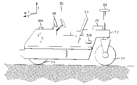
[0010] FIG. 2 shows a virtual profilograph system on an asphalt compactor
in
accordance with an embodiment of the present invention ;
[0011] FIG. 3 shows a GPS control system useful in the virtual profilograph
system
of FIG. 2; and
[0012] FIG. 4 shows an illustrative display of the virtual profilograph
system in
accordance with an embodiment of the present invention.
DETAILED DESCRIPTION
[0013] FIG. 2 shows a construction machine 202 in accordance with an
embodiment
of the present invention. Specifically, that figure shows an asphalt
compactor, once
again also referred to herein interchangeably as a roller, adapted to compact
the
material used to construct a roadway. In one particular embodiment, the roller
202 has
two cylindrical compacting rollers 214 for compacting the road surface as
roller 202
moves across the roadway. The configuration of a roller such as roller 202 is
well-
known in the art and will not be described in further detail herein other than
is necessary
to understand the principles of the present invention. Roller 202 has,
illustratively, a
satellite antenna 208 connected to the roller body 212 that is used to receive
signals
from Global Navigation Satellite Systems (GNSS). GNSS are well known and used
to
solve a wide variety of positioning/time related tasks. Two well known such
systems are
the Global Positioning System (GPS) of the United States and the GLObal
NAvigation
Satellite System (GLONASS) of Russia. For ease of reference, this description
will
Page 5 -
CA 02569494 2006-11-30
Docket No. 1010-0013-CAN
generally refer to the GPS system, but it is to be understood that the present
description
is equally applicable to GLONASS, combined GPS + GLONASS, or other GNSS
systems.
[0014] One skilled in the art will recognize that the position of GPS
antenna 208 can
be located with a high degree of precision. The precision can be further
enhanced
using differential GPS, or DGPS, which is well known. Such DGPS methods allow
the
position of antenna 208 to be determined within, for example, 2 cm vertically,
along the
y-axis in FIG. 2, and within, also by way of example, 1 cm laterally, along
the x and z
axes in FIG. 2. This precision can be even further enhanced via the use of
more recent
techniques that provide even more accurate position measurements. For example,
some more recent satellite positioning systems incorporate laser transmitters
at a
stationary location to transmit a signal that is received by a laser receiver
on roller 202.
Based on the signal characteristics of the signal received by the receiver and
the known
location of the stationary transmitter, positional measurements of a satellite
positioning
system can be enhanced such that the position of antenna 208 can be determined
within, for example, 5 millimeter accuracy vertically, along the y-axis in
FIG. 2, and
within, also by way of example, 1 centimeter laterally, along the x and z axes
in FIG. 2.
[0015] Thus, as one skilled in the art will recognize, the configuration
described
above allows for the precise measurement of the Cartesian coordinate position
of
antenna 208 on roller 202 as well as the linear velocity of that antenna. The
antenna is
mounted rigidly in a stationary position on the body of roller 202. Therefore,
the position
of any other component of roller 202 that is also mounted stationary with
respect to the
body of the roller 202 can be located as accurately as that of the antenna via
simple
Page 6
CA 02569494 2006-11-30
Docket No. 1010-0013-CAN
geometric calculations. Particularly, knowing the position of antenna 208
permits the
precise position of the cylindrical rollers 214 to be known which, when
combined with
different measurements over time, allows the heading and position of the
roller 202 to
be determined with corresponding accuracy. In addition to GPS antenna 208, in
another embodiment roller 202 also has tilt sensors 204A and 204B, more
generally.
Tilt sensor 204A may be used, for example, to measure whether roller 202 is
traveling
horizontally in the X ¨ Z plane or whether it is traveling uphill or downhill
with respect to
that plane. Tilt sensor 204B, on the other hand, may be used to determine
whether
roller 202 is tilted about the longitudinal axis of the roller, i.e., whether
the roller is rolling
to one side or the other with respect to a horizontal X ¨ Z plane.
[0016] One skilled in the art will recognize that, instead of tilt sensors
204A and
204B, multiple GPS antennas can be placed on the body of roller 202 to
accomplish the
same function. For example, if a second antenna is placed on the roller body,
but is
offset in both the z and x directions with respect to antenna 208, both the
tilt and slope
orientation of roller 202 can be determined by comparing the relative three-
dimensional
positions of the two antennas. One skilled in the art will be able to devise
various
equally advantageous placements and configurations of GNSS antennas in order
to
determine the positions and orientations of roller 202 and cylindrical rollers
214 as
described above. Thus, the precise position, velocity, heading and orientation
(e.g.,
slope and tilt) of roller 202 and its various components, such as rollers 214,
can be
determined. Therefore, by taking multiple measurements over time as the roller
moves
across a surface, a precise profile of the roadway can be determined.
Page 7
CA 02569494 2006-11-30
Docket No. 1010-0013-CAN
[0017] One skilled in the art will also recognize that the antenna 208 of
FIG. 2 may
be connected to a GNSS control system, such as GPS receiver 210 in FIG. 2,
which
may be implemented on a programmable computer adapted to perform the steps of
a
computer program to calculate and display the position of the roller 202
and/or the
cylindrical rollers 214 on illustrative terminal 206 in FIG. 2. Referring to
FIG. 3, such a
control system 210 may be implemented on any suitable computer adapted to
receive,
store and transmit data such as data associated with the aforementioned
antenna
location(s). Specifically, illustrative control system 210 may have, for
example, a
processor 302 (or multiple processors) which controls the overall operation of
the
control system 210. Such operation is defined by computer program instructions
stored
in a memory 303 and executed by processor 302. The memory 303 may be any type
of
computer readable medium, including without limitation electronic, magnetic,
or optical
media. Further, while one memory unit 303 is shown in FIG. 3, it is to be
understood
that memory unit 303 could comprise multiple memory units, with such memory
units
comprising any type of memory. Control system 210 also comprises illustrative
modem
301 and network interface 304. Control system 210 also illustratively
comprises a
storage medium, such as a computer hard disk drive 305 for storing, for
example, data
and computer programs adapted for use in accordance with the principles of the
present
invention as described hereinabove. Finally, control system 210 also
illustratively
comprises one or more input/output devices, represented in FIGs. 2 and 3 as
terminal
206, for allowing interaction with, for example, a technician or machine
operator.
Terminal 206 illustratively has display 307 and input device (here, a
keyboard) 308.
One skilled in the art will recognize that control system 210 and terminal 206
may be
Page 8
CA 02569494 2006-11-30
Docket No. 1010-0013-CAN
located directly on roller 202 or, for example, may be located remote from
roller 202.
One skilled in the art will also recognize that control system 210 is merely
illustrative in
nature and that various hardware and software components may be adapted for
equally
advantageous use in a computer in accordance with the principles of the
present
invention.
[0018] FIG. 4 shows an illustrative graph 400 created by the control system
and
displayed on a paper graph or, alternatively, on a display, such as display
307 of
terminal 206 in FIG. 3. Referring to FIG. 4, graph 400 has vertical axis 402
representing
the elevation of the GNSS antenna 208 of FIG. 2 with respect to an initial
starting
elevation 404. Illustratively, the elevation represented by axis 402 is
displayed in
centimeters. Graph 400 also has horizontal axis 403 representing the distance
traveled
from a starting point on a roadway, illustratively shown as starting point 405
in graph
400. The distance represented by axis 403 is, for example, displayed in feet.
One
skilled in the art will recognize that many different resolutions using
different units of
measurement for axes 402 and 403 may be used with equally advantageous results
depending on road conditions (i.e., the relative roughness or smoothness of
the road).
One skilled in the art will also recognize that the distances represented by
axes 402 and
403 may be expressed in any suitable units or, alternatively, may be a
relative unit-less
elevation. As roller 202 of FIG. 2 moves across the roadway, vertical and
horizontal
position measurements taken by the GNSS control system of FIG. 3 and as
described
above are plotted on graph 400 as a function of the distance traveled by the
roller.
Alternatively, the raw positional data represented by these vertical and
horizontal
position measurements may be averaged, for example over various distances, or
Page 9
CA 02569494 2006-11-30
Docket No. 1010-0013-CAN
otherwise mathematically smoothed to simulate the way a mechanical
profilograph
measures fast elevation changes of wheel 108 in FIG. 1 with respect to wheel
assemblies 101, as discussed above. In either case, plot 401 represents the
surface of
the roadway across which the roller moves and, thus, may be used to assess the
ride
quality of vehicles traveling across the surface of the roadway.
[0019] The foregoing Detailed Description is to be understood as being in
every
respect illustrative and exemplary, but not restrictive, and the scope of the
invention
disclosed herein is not to be determined from the Detailed Description, but
rather from
the claims as interpreted according to the full breadth permitted by the
patent laws. It is
to be understood that the embodiments shown and described herein are only
illustrative
of the principles of the present invention and that various modifications may
be
implemented by those skilled in the art without departing from the scope and
spirit of the
invention.
Page 10