Note : Les descriptions sont présentées dans la langue officielle dans laquelle elles ont été soumises.
CA 02576216 2012-05-09
AIRCRAFT IDENTIFICATION AND DOCKING GUIDANCE SYSTEMS
This application is a divisional of Canadian patent application Serial No.
2,389,205
filed internationally on October 27, 2000 and entered nationally on April 26,
2002.
REFERENCE TO RELATED APPLICATIONS
This is a continuation-in-part of U.S. Patent Application No. 09/429,609,
filed
October 29, 1999, issued as U.S. Patent No. 6,324,489, which is a continuation-
in-part of
U.S. Patent Application No. 08/817,368, filed July 17, 1997, now U.S. Patent
No.
6,023,665, which is the U.S. national stage of PCT International Application
No.
PCT/SE94/00968, filed October 14, 1994, published April 25, 1996, as WO
96/12265
Al.
BACKGROUND OF THE INVENTION
Field of the Invention
10. This invention relates to systems for locating, identifying and tracking
objects. More
particularly, it related to aircraft location, identification and docking
guidance systems and to
ground traffic control methods for locating and identifying objects on an
airfield and for. safely
and efficiently docking aircraft at such airport.
Description of Related Art
In recent years there has been a significantly increased amount of passenger,
cargo and
other aircraft traffic including take offs, landings and other aircraft ground
traffic. Also, there
has been a marked increase in the number of ground support vehicles which are
required to off
load cargo, provide catering services and on going maintenance and support of
all aircraft. With
that substantial increase in ground traffic has come a need for greater
control and safety in the
docking and identification of aircraft on an airfield.
1
CA 02576216 2007-02-14
Exemplary of prior art systems which have been proposed for detecting the
presence of
aircraft and other traffic on an airfield are those systems disclosed in U.S.
Patent 4,995,102;
European Patent No. 188 757; and PCT Published Applications WO 93/13104 and WO
93/15416.
However, none of those systems have been found to be satisfactory for
detection of the
presence of aircraft on an airfield, particularly, under adverse climatic
conditions causing
diminished visibility such as encountered under fog, snow or sleet conditions.
Furthermore, none
of the systems disclosed in the prior references are capable of identifying
and verifying the
specific type of an approaching aircraft. Still further, none of the prior
systems provide adequate
techniques for tracking and docking an aircraft at a designated stopping point
such as an airport
loading gate. Also, none of the prior systems have provided techniques which
enable adequate
calibration of the instrument therein.
The system disclosed in the above-cited parent application seeks to overcome
the above-
noted problems though profile matching. Light pulses from a laser range finder
(LRF) are
projected in angular coordinates onto the airplane. The light pulses are
reflected off the airplane
to detect a shape of the airplane or of a portion of the airplane, e.g., the
nose. The detected shape
is compared with a profile corresponding to the shape of a known model of
airplane to determine
whether the detected shape corresponds to the shape of the known model.
However, that system has a drawback. Often, two or more models of airplanes
have nose
profiles so similar that one model is often misidentified as another. In
particular, in adverse
weather, many echoes are lost, so that profile discrimination becomes
decreasingly reliable.
Since the models are similar but not identical in body configuration, a
correct docking position
for one can cause an engine on another to crash into a physical obstacle.
2
CA 02576216 2007-02-14
Thus, it has been a continuing problem to provide systems which are
sufficiently safe and
reliable over a wide range of atmospheric conditions to enable detection of
objects such as
aircraft and other ground traffic on an airfield.
In addition, there has been a long standing need for systems which are not
only capable
of detecting objects such as aircraft, but which also provide for the
effective identification of the
detected object and verification of the identity of such object, for example,
a detected aircraft
with the necessary degree of certainty regardless of prevailing weather
conditions and magnitude
of ground traffic.
There has also been a long standing, unfulfilled need for systems which are
capable of
accurately and efficiently tracking and guiding objects such as incoming
aircraft to a suitable
stopping point such as an airport loading gate. In addition, the provision of
accurate and
effective calibration techniques for such systems has been .a continuing
problem requiring
resolution.
3
CA 02576216 2007-02-14
SUMMARY OF THE INVENTION
It will be readily apparent from the above that a need exists in the art for a
more accurate
identification of aircraft.
It is therefore a primary object of the invention to distinguish among
multiple models of
aircraft with identical or almost identical nose shapes.
It is a further object of the invention to improve the detection of aircraft
so as to avoid
accidents during aircraft docking.
To achieve the above and other objects, the present invention identifies
aircraft in a two-
step process. First, the profile matching is performed as known from the above-
identified parent
application. Second, at least one aircraft criterion matching is performed. In
the aircraft criterion
matching, a component of the aircraft, such as the engine, is selected as a
basis for distinguishing
among aircraft. The displacement of that component from another, easily
located component,
such as the nose, is determined in the following manner. An inner volume in
which the engine
is expected is defined, and an outer volume surrounding the inner volume is
also defined. The
LRF is directed at the inner and outer volumes to produce echoes from both
volumes. A ratio
is taken of the number of echoes in the inner volumes to the number of echoes
in both volumes.
If that echo exceeds a given threshold, the engine is determined to be present
in the inner volume,
and the aircraft is considered to be identified. If the identification of the
aircraft is still
ambiguous, another aircraft criterion, such as the tail, can be detected.
The aircraft criteria chosen for the second phase of the identification are
physical
differences that can be detected by a laser range finder. An example of such a
criterion is the
position, sideways and lengthwise, of an engine in relation to the aircraft
nose. To consider an
aircraft identified, the echo pattern must not only reflect a fuselage of
correct shape. It must also
4
CA 02576216 2007-02-14
reflect that there is an engine at a position. relative to the nose, where the
expected aircraft does
have an engine. Other examples of criteria that can be used are the position
of the main gear, the
position of the wings and the position of the tail.
The matching is preferably done only against the criteria specific for the
expected aircraft
type. It would be very time consuming to match against the criteria of all
other possible types.
Such matching would have to be against every type of aircraft that may land at
a specific airport.
For each gate there is a defined a stopping position for each aircraft type
that is planned
to dock at that gate. There might be a safety risk for any other type to
approach the gate. The
stopping position is defined so that there is a sufficient safety margin
between the gate and the
aircraft to avoid collision. The stopping position for each aircraft type is
often defined as the
position of the nose gear when the door is in appropriate position in relation
to the gate. There
is a database in the system where the distance from the nose to the nose gear
is stored for each
aircraft type. The docking system guides the aircraft with respect to its nose
position and stops
the aircraft with its nose in a position where the correct type will have its
nose gear in the correct
stop position. If the wrong type is docked and if it has its wings or engines
closer to the nose than
the correct type, there is a risk of collision with the gate.
During the aircraft criteria phase, all aircraft criteria specified for the
expected aircraft
type can be checked. If an aircraft has a profile that can be used to
discriminate it from any other
type, which is rarely the case, the profile will be the only aircraft
criterion. Otherwise, another
criterion such as the position of the engine is checked, and ifthe
identification is still ambiguous,
still another criterion such as the position of the tail is checked.
The LRF is directed to obtain echoes from the inner and outer volumes. If the
ratio of
the number of echoes from within the inner volume to the number of echoes from
within both
5
CA 02576216 2007-02-14
volumes is larger than a threshold value, the aircraft is identified as having
an engine at the right
position, and that specific criterion is thus fulfilled. The ratio of the echo
numbers is, however,
just an example of a test used to evaluate the presence of an engine at the
right position or to
determine whether the echoes come from some other source, e.g., a wing. In
cases in which that
is the only criterion, the aircraft is considered to be identified. Otherwise,
the other specified
criteria (e.g., the height of the nose of the aircraft or evaluation of
another aircraft criterion) have
to be fulfilled.
If necessary, several characteristics, such as the tail, gears, etc., can be
used to identify
one specific type. The inner and outer volumes are then defined for each
geometrical
characteristic to be used for the identification. The exact extension of the
volumes is dependent
on the specific aircraft type and so is the threshold value.
A further identification criterion is the nose height. The nose height is
measured so as
to allow the horizontal scan to be placed over the tip of the nose. The
measured nose height is
also compared with the height of the expected aircraft. If the two differ by
more than 0.5 in, the
aircraft is considered to be of wrong type, and the docking is stopped. The
value 0.5 in is given
by the fact that the ground height often varies along the path of the aircraft
which makes it
difficult to measure with higher accuracy.
The invention lends itself to the use of "smart" algorithms which minimize the
demand
on the signal processing at the same time as they minimize the effect of
adverse weather and bad
reflectivity of aircraft surface. The advantage is that low-cost
microcomputers can be used,
and/or computer capacity is freed for other tasks, and that docking is
possible under almost all
weather conditions.
6
CA 02576216 2007-02-14
One important algorithm in that respect is the algorithm for handling of the
reference
profiles. The profile information is stored as a set of profiles. Each profile
in the set reflects the
expected echo pattern for the aircraft at a certain distance from the system.
The position of an
aircraft is calculated by calculating the distance between the achieved echo
pattern with the
closest reference profile. The distance interval between the profiles in the
set is chosen so short
that the latter calculation can be made using approximations and still
maintain the necessary
accuracy. Instead of using scaling with a number of multiplications, which is
a demanding
operation, simple addition and subtraction can be used.
Another important algorithm is the algorithm for determining an aircraft's
lateral
deviation from its appropriate path. That algorithm uses mainly additions and
subtractions and
only very few multiplications and divisions. The calculation is based on areas
between the
reference profile and the echo pattern. As those areas are not so much
affected by position
variations or absence of individual echoes the algorithm becomes very
insensitive to disturbances
due to adverse weather.
The calibration procedure enables a calibration check against an object at the
side of the
system. The advantage is that such a calibration check is possible also when
no fixed object is
available in front of the system. In most cases, there are no objects in front
of the system that can
be used. It is very important to make a calibration check regularly. Something
might happen to
the system, e.g., such that the aiming direction of the system is changed.
That can be due to an
optical or mechanical error inside the system or it can be due to a
misalignment caused by an
external force such as from a passing truck. If that happens, the system may
guide an aircraft to
a collision with objects at the side of its appropriate path.
7
CA 02576216 2007-02-14
Another useful aspect of the present invention is that it can easily be
adapted to take into
account the yaw angle of the aircraft. The yaw angle is useful to know for two
reasons. First,
knowledge of the yaw angle facilitates accurate docking of the aircraft.
Second, once the yaw
angle is determined, the profile is rotated accordingly, for more accurate
matching.
In the verification process it is determined whether certain geometric
characteristics, such
as an engine, are present in a certain position, e.g., relative to the nose.
If the aircraft is directed
at an angle towards the docking guidance system (DGS), which is often the
case, that angle has
to be known, in order to know where to look for the characteristics. The
procedure is as follows:
1. Convert the polar coordinates (angle, distance) of the echoes to Cartesian
coordinates
(x,y).
2. Calculate the yaw angle.
3. Rotate the echo profile to match the yaw angle calculated for the aircraft.
4. Determine the existence of the ID characteristics.
The yaw angle is typically calculated through a technique which involves
finding
regression angles on both sides of the nose of the aircraft. More broadly, the
geometry of the part
of the aircraft just behind the nose is used. Doing so was previously
considered to be impossible.
Still another aspect of the invention concerns the center lines painted in the
docking ara.
Curved docking center lines are painted as the correct path for the nose wheel
to follow, which
is not the path for the nose. If a DGS does not directly measure the actual
position of the nose
wheel, the yaw angle is needed to calculate it based on measured data, such as
the position of the
nose. The position of the nose wheel in relation to the curved center line can
then be calculated.
8
CA 02576216 2012-05-09
The invention thus provides according to a first aspect, for a system for
determining a yaw angle of a detected object, the system comprising:
projecting means for
projecting light pulses onto the detected object; collecting means for
collecting light pulses
reflected off the detected object and for detecting a shape of the detected
object in
accordance with the light pulses; and angle determining means for determining
the yaw
angle from the shape detected by the collecting means.
According to a second aspect, the invention provides for a method of
determining a yaw angle of a detected object, the method comprising:
projecting light
pulses onto the detected object; collecting light pulses reflected off the
detected object
and detecting a shape of the detected object in accordance with the light
pulses; and
determining the yaw angle from the shape detected by the collecting means.
According to another aspect, there is provided a system for determining a yaw
angle of a detected object, the system comprising: projecting means for
projecting light
pulses onto the detected object; collecting means for collecting light pulses
reflected off
the detected object and for detecting a shape of the detected object in
accordance with the
light pulses; and angle determining means for determining the yaw angle from
the shape
detected by the collecting means. The detected object comprises a nose having
a nose tip,
and a left side and a right side relative to the nose tip. The angle
determining means
determines a regression line on at least one of the left side and the right
side and
determines the yaw angle from one of a difference in angle between the
regression line
and a corresponding part of a reference profile for the detected object, or a
difference in
angle between regression lines.
According to another aspect there is provided a method of determining a yaw
angle
of a detected object, the method comprising: projecting light pulses onto the
detected
object; collecting light pulses reflected off the detected object and
detecting a shape of the
detected object in accordance with the light pulses; and determining the yaw
angle from
the shape detected by the collecting means. The detected object comprises a
nose having a
nose tip, and a left side and a right side relative to the nose tip. The
action of determining
the yaw angle comprises determining a regression line on at least one of the
left side and
the right side and determining the yaw angle from one of a difference in angle
between the
regression line and a corresponding part of a reference profile for the
detected object, or a
difference in angle between regression lines.
8a
CA 02576216 2007-02-14
BRIEF DESCRIPTION OF THE DRAWINGS
The features and advantages of the invention will become apparent from the
following
detailed description taken in connection with the accompanying drawings
wherein:
Fig 1 is a view illustrating the system as in use at an airport;
Fig 2 is a diagrammatic view illustrating the general componentry of a
preferred system in accordance with the present invention;
Fig 3 is a top plan view illustrating the detection area in front of a
docking gate which is established for purposes of detection and
identification of approaching aircraft;
Figs 4A and 4B together show a flow chart illustrating the main routine and
the
docking mode of the system;
Fig 5 is a flow chart illustrating the calibration mode of the system;
Fig 6 is a view illustrating the components of the calibration mode;
Fig 7 is a flow chart illustrating the capture mode of the system;
Fig 8 is a flow chart illustrating the tracking phase of the system;
Fig 9 a is flow chart illustrating the height measuring the phase of the
system;
Fig 10 is a flow chart illustrating the identification phase of the system.
Fig 11 is a flow chart illustrating the aircraft criterion phase of the
system;
Fig 12 is a diagram showing inner and outer volumes around an aircraft engine
used in the aircraft criterion phase;
Fig 13 is a diagram showing the tolerance limits of the measured nose-to-
engine distance for accepting an aircraft into a gate;
9
CA 02576216 2007-02-14
Fig 14 is a diagram showing the dependence of the safety margin on the
nose-to-engine distance in a situation in which an aircraft of the
wrong type is docked at the gate
Fig. 15 is a flow chart showing the basic steps used in recognizing an
aircraft which is at a yaw angle to the gate;
Fig. 15A is a diagram showing the geometry of the yaw angle;
Fig. 16 is a diagram showing the geometry used in determining the
regression lines which are used in calculating the yaw angle;
Fig. 17 is a flow chart showing the steps used in calculating the yaw
angle;
Fig. 18 is a diagram showing the geometry used in rotating an echo
profile;
Fig. 19 is a flow chart showing the steps used in rotating the echo profile;
Fig. 20 is a flow chart showing the steps used in calculating an offset of
a nose wheel of an aircraft from a center line;
Fig. 21 is a diagram showing the geometry of the position of the nose
wheel relative to that of the nose; and
Fig. 22 is a diagram showing the geometry of the position of the nose
wheel relative to the center line.
Table I is a preferred embodiment of a Horizontal Reference Profile Table
which is employed to establish the identity of an aircraft in the
systems of the present invention;
CA 02576216 2007-02-14
Table II is a preferred embodiment of a Comparison Table which is
employed in the systems of the present invention for purposes of
effectively and efficiently docking an aircraft.
11
CA 02576216 2007-02-14
DETAILED DESCRIPTION OF THE PREFERRED EMBODIMENT
Reference is now made to Figures 1-22 and Tables I-II, in which like numerals
designate
like elements throughout the several views. Throughout the following detailed
description,
numbered stages depicted in the illustrated flow diagrams are generally
indicated by element
number in parenthesis following such references.
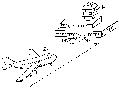
Referring to Fig. 1, the docking guidance systems of the present invention
generally
designated 10 in the drawings provide for the computerized location of an
object, verification of
the identity of the object and tracking of the object, the object preferably
being an aircraft 12.
In operation, once the control tower 14 lands an aircraft 12, it informs the
system that a plan is
approaching gate 16 and the type of aircraft (i.e., 747, L-1011, etc.)
expected. The system 10
then scans the area in front of the gate 16 until it locates an object that it
identifies as an airplane
12. The system 10 then compares the measured profile of the aircraft 12 with a
reference profile
for the expected type of aircraft and evaluates other geometric criteria
characteristic of the
expected aircraft type. If the located aircraft does not match the expected
profile and the other
criteria, the system informs or signals the tower 14 and shuts down.
If the object is the expected aircraft 12, the system 10 tracks it into the
gate 16 by
displaying in real time to the pilot the distance remaining to the proper
stopping point 29 and the
lateral position 31 of the plane 12. The lateral position 31 of the plane 12
is provided on a
display 18 allowing the pilot to correct the position of the plane to approach
the gate 16 from the
correct angle. Once the airplane 12 is at its stopping point 53, that fact is
shown on the display
18 and the pilot stops the plane.
Referring to Fig. 2, the system 10 includes a Laser Range Finder (LRF) 20, two
mirrors
21, 22, a display unit 18, two step motors 24, 25, and a microprocessor 26.
Suitable LRF
12
CA 02576216 2007-02-14
products for use herein are sold by Laser Atlanta Corporation and are capable
of emitting laser
pulses and receiving the reflections of those pulses reflected off of distant
objects and computing
the distance to those objects.
The system 10 is arranged such that there is a connection 28 between the
serial port of
the LRF 20 and the microprocessor 26. Through that connection, the LRF 20
sends measurement
data approximately every 1/400th of a second to the microprocessor 26. The
hardware
components generally designated 23 of the system 20 are controlled by the
programmed
microprocessor 26. In addition, the microprocessor 26 feeds data to the
display 18. As the
interface to the pilot, the display unit 18 is placed above the gate 16 to
show the pilot how far the
plane is from its stopping point 29, the type of aircraft 30 the system
believes is approaching and
the lateral location of the plane 31. Using that display, the pilot can adjust
the approach of the
plane 12 to the gate 16 to ensure the plane is on the correct angle to reach
the gate. If the display
18 shows the wrong aircraft type 30, the pilot can abort the approach before
any damage is done.
That double check ensures the safety of the passengers, plane and airport
facilities because if the
system tries to dock a larger 747 at a gate where a 737 is expected, it likely
will cause extensive
damage.
In addition to the display 18, the microprocessor 26 processes the data from
LRF 20 and
controls the direction of the laser 20 through its connection 32 to the step
motors 24, 25. The
step motors 24, 25 are connected to the mirrors 21, 22 and move them in
response to instructions
from the microprocessor 26. Thus, by controlling the step motors 24, 25, the
microprocessor 26
can change the angle of the mirrors 21, 22 and aim the laser pulses from the
LRF 20.
The mirrors 21, 22 aim the laser by reflecting the laser pulses outward over
the tarmac
of the airport. In the preferred embodiment, the LRF 20 does not move. The
scanning by the
13
CA 02576216 2007-02-14
laser is done with mirrors. One mirror 22 controls the horizontal angle of the
laser while the
other mirror 21 controls the vertical angle. By activating the step motors 24,
25, the
microprocessor 26 controls the angle of the mirrors and thus the direction of
the laser pulse.
The system 10 controls the horizontal mirror 22 to achieve a continuous
horizontal
scanning within a 10 degree angle in approximately 0.1 degree angular steps
which are
equivalent to 16 microsteps per step with the Escap EDM-453 step motor. One
angular step is
taken for each reply from the reading unit, i.e., approximately every 2.5 ms.
The vertical mirror
21 can be controlled to achieve a vertical scan between +20 and -30 degrees in
approximately
0.1 degree angular steps with one step every 2.5 ms. The vertical mirror is
used to scan vertically
when the nose height is being determined and when the aircraft 12 is being
identified. During
the tracking mode, the vertical mirror 21 is continuously adjusted to keep the
horizontal scan
tracking the nose tip of the aircraft 12.
Referring to Fig. 3, the system 10 divides the field in front of it by
distance into three
parts. The farthest section, from about 50 meters out, is the capture zone 50.
In that zone 50, the
system 10 detects the aircraft's nose and makes a rough estimate of lateral
and longitudinal
position of the aircraft 12. Inside the capture zone 50 is the identification
area 51. In that area,
the system 10 checks the profile of the aircraft 12 against a stored profile
51. In that area, the
system 10 checks the profile of the aircraft 12 in that region, related to a
predetermined line, on
the display I 8. Finally, nearest to the LRF 20 is the display or tracking
area 52. In the display
area 52, the system 10 displays the lateral and longitudinal position of the
aircraft 12 relative to
the correct stopping position with its highest degree of accuracy. At the end
of the display area
52 is the stopping point 53. At the stopping point 53, the aircraft will be in
the correct position
at the gate 16.
14
CA 02576216 2007-02-14
In addition to the hardware and software, the system 10 maintains a database
containing
reference profiles for any type of aircraft it might encounter. Within that
database, the system
stores the profile for each aircraft type as a horizontal and vertical profile
reflecting the expected
echo pattern for that type of aircraft.
Referring to Table I, the system maintains the horizontal profile in the form
of a Table
I whose rows 40 are indexed by angular step and whose columns 41 are indexed
by distance from
the stopping position for that type of aircraft. In addition to the indexed
rows, the table contains
a_ row 42 providing the vertical angle to the nose of the plane at each
distance from the LRF a
row 44 providing the form factor, k, for the profile and a row 45 providing
the number of profile
values for each profile distance. The body 43 of the Table I contains expected
distances for that
type of aircraft at various scanning angles and distances from the stopping
point 53.
Theoretically, the 50 angular steps and the 50 distances to the stopping point
53 would
require a Table I containing 50 x 50, or 2500, entries. However, Table I will
actually contain far
fewer entries because the profile will not expect a return from all angles at
all distances. It is
expected that a typical table will actually contain between 500 and 1000
values. Well known
programming techniques provide methods of maintaining a partially full table
without using the
memory required by a full table.
In addition to the horizontal profile, the system 10 maintains a vertical
profile of each
type of aircraft. That profile is stored in the same manner as the horizontal
profile, except that
its rows are indexed by angular steps in the vertical direction and its column
index contains fewer
distances from the stopping position than the horizontal profile. The vertical
profile requires
fewer columns because it is used only for identifying the aircraft 12 and for
determining its nose
height, which take place at a defined range of distances from the LRF 20 in
the identification area
CA 02576216 2007-02-14
51. Consequently, the vertical profile stores only the expected echoes in that
range without
wasting data storage space on unneeded values.
The system 10 uses the previously described hardware and database to locate,
identify
and track aircraft using the following procedures:
Referring to Figs. 4A and 4B, the software running on the microprocessor
performs a
main routine containing subroutines for the calibration mode 60, capture mode
62 and docking
mode 400. The microprocessor first performs the calibration mode 60, then the
capture mode
62 and then the docking mode 400. Once the aircraft 12 is docked, the program
finishes. Those
modes are described in greater detail as follows:
Calibration Mode
To ensure system accuracy, the microprocessor 26 is programmed to calibrate
itself in
accordance with the procedure illustrated in Fig. 5 before capturing an
aircraft 12 and at various
intervals during tracking. Calibrating the system 10 ensures that the
relationship between the
step motors 24, 25 and the aiming direction is known. The length measuring
ability of the LRF
20 is also checked.
Referring to Fig. 6, for calibration, the system 10 uses a square plate 66
with a known
position. The plate 66 is mounted 6 meters from the LRF 20 and at the same
height as the LRF
20.
To calibrate, the system sets (a,p) to (0,0), causing the laser to be directed
straight
forward. The vertical mirror 22 is then tilted such that the laser beam is
directed backwards to
a rear or extra mirror 68 which redirects the beam to the calibration plate
66. (100) The
microprocessor 26 then uses the step motors 24, 25, to move the mirrors 21, 22
until it finds the
center of the calibration plate 66. Once it finds the center of the
calibration plate 66, the
16
CA 02576216 2007-02-14
microprocessor 26 stores the angles (an, (3n) at that point and compares them
to stored expected
angles. (102) The system 10 also compares the reported distance to the plate
66 center with a
stored expected value. (102) If the reported values do not match the stored
values, the
microprocessor 26 changes the calibration constants, which determine the
expected values, until
they do. (104, 106) However, if any of those values deviate too much from the
values stored at
installation, an alarm is given. (108)
Capture Mode
Initially, the airport tower 14 notifies the system 10 to expect an incoming
airplane 12
and the type of airplane to expect. That signal puts the software into a
capture mode 62 as
outlined in Fig. 7. In capture mode 62, the microprocessor 26 uses the step
motors 24, 25 to
direct the laser to scan the capture zone 50 horizontally for the plane 12.
That horizontal scan
is done at a vertical angle corresponding to the height of the nose of the
expected type of aircraft
at the midpoint of the capture zone 50.
To determine the correct height to scan, the microprocessor 26 computes the
vertical
angle for the laser pulse as:
(iarctan [ (H-h)/1 f ]
where H = the height of the LRF 20 above the ground, h = the nose height of
the expected
aircraft, and If = the distance from the LRF 20 to the middle of the capture
zone 50. That
equation results in a vertical angle for the mirror 21 that will enable the
search to be at the correct
height at the middle of the capture zone 50 for the expected airplane 12.
Alternatively, the system 10 can store in the database values for (if for
different types of
aircraft at a certain distance. However, storing (3f limits the flexibility of
the system 10 because
it can capture an aircraft 12 only a single distance from the LRF 20
17
CA 02576216 2007-02-14
In the capture zone 50 and using that vertical angle, the microprocessor 26
directs the
laser to scan horizontally in pulses approximately 0.1 degree apart. The
microprocessor 26 scans
horizontally by varying a. the horizontal angle from a center line starting
from the LRF 20,
between amax, a value defined at installation. Typically, ama, is set to 50
which, using 0.1 degree
pulses, is equivalent to 5 degrees and results in a 10 degree scan.
The release of the laser pulses results in echoes or reflections from objects
in the capture
zone 50. The detection device ofthe LRF 20 captures the reflected pulses,
computes the distance
to the object from the time between pulse transmission and receipt of the
echo, and sends the
calculated distance value for each echo to the microprocessor 26. The micro
processor 26 stores,
in separate registers in a data storage device, the total number of echoes or
hits in each 1 degree
sector of the capture zone 50. (70) Because the pulses are generated in 0.1
degree intervals, up
to ten echoes can occur in each sector. The microprocessor 26 stores those
hits in variables
entitled sa where a varies from 1 to 10 to reflect each one degree slice of
the ten degree capture
zone 50.
In addition to storing the number of hits per sector, the microprocessor 26
stores, again
in a data storage device, the distance from the LRF 20 to the object for each
hit or echo. Storing
the distance to each reflection requires a storage medium large enough to
store up to ten hits in
each 1 degree of the capture zone 50 or up to 100 possible values. Because, in
many cases, most
of the entries will be empty, well known programming techniques an reduce
those storage
requirements below having 100 registers always allocated for those values.
Once that data is available for a scan, the microprocessor 26 computes the
total number
of echoes, Sr. in the scan by summing the sa's. The microprocessor 26 then
computes S,,, the
18
CA 02576216 2007-02-14
largest sum of echoes in three adjacent sectors. ' (72) In other words, S.õ is
the largest sum of (Sa-,,
S.' s.11).
Once it computes SA, and S,., the microprocessor 26 determines whether the
echoes are
from an incoming airplane 12. If SM is not greater than 24, no airplane 12 has
been found and
the microprocessor 26 returns to the beginning of the capture mode 62. If the
largest sum of
echoes, Sõ is greater than 24 (74), a "possible" airplane 12 has been located.
If a "possible"
airplane 12 has been located, the microprocessor checks if S.+/S,T is greater
than 0.5 (76), or the
three adjacent sectors with the largest sum contain at least half of all the
echoes received during
the scan.
If SM /SM is greater than 0.5, the microprocessor 26 calculates the location
of the center
of the echo. (78, 82) The angular location of the center of the echo is
calculated as:
a, = a,, + (Sa+I - S.-I)/(S.-2 + S. + Sa+,)
where Sa is the Sa that gave SM and aõ is the angular sector that corresponds
to that Sa.
The longitudinal position of the center of the echo is calculated as
1 10
1, = n L lavi
i_1
where the la,,; are the measured values, or distances to the object, for the
pulses that returned an
echo from the sector a,, and where n is the total number of measured values in
that sector. (78,
82) Because the largest possible number of measured values is ten, n must be
less than or equal
to ten.
However, if S M/ST < 0.5, the echoes may have been caused by snow or other
aircraft at
close range. If the cause is an aircraft at close range, that aircraft is
probably positioned fairly
close to the centerline so it is assumed that a, should be zero instead of the
above calculated
19
CA 02576216 2007-02-14
value and that It should be the mean distance given by the three middle
sectors. (80) If the
distance distribution is too large, the microprocessor 26 has not found an
airplane 12 and it
returns to the beginning of the capture mode 62. (81).
After calculating the position of the aircraft 12, the system 10 switches to
docking mode
400.
Docking Mode
The docking mode 400 illustrated in Figs. 4A and 4B includes four phases, the
tracking
phase 84, the height measuring phase 86, the profile recognition phase 404,
and the aircraft
criteria phase 408. In the tracking phase 84, the system 10 monitors the
position of the incoming
aircraft 12 and provides the pilot with information about axial location 31
and distance from the
stopping point 53 of the plane through the display 18. The system 10 begins
tracking the aircraft
12 by scanning horizontally.
Referring to Fig. 8, during the first scan in tracing phase, the
microprocessor 26 directs
the LRF 20 to send out laser pulses in single angular steps, a or, preferably,
at 0.1 degree
intervals between (a, - ap - 10) and (a, + a1, + 10), where a, is determined
during the capture
mode 62 as the angular position of the echo center and as is the largest
angular position in the
current profile column that contains distance values.
After the first scan, a is stepped back and forth with one step per received
LRF value
between (a, - ap - 10) and (a, + ap + 10), where as is the angular position of
the azimuth
determined during the previous scan.
During the tracking phase 84, the vertical angle f3 is set to the level
required for the
identified craft 12 at its current distance from the LRF 20 which is obtained
from the reference
CA 02576216 2007-02-14
profile Table I. The current profile column is the column representing a
position less than but
closer to l,.
The microprocessor 26 uses the distance from the stopping point 53 to find the
vertical
angle for the airplane's current distance on the profile Table I. During the
first scan, the
distance, lõ calculated during the capture mode 62, determines the appropriate
column of the
profile Table I and thus the angle to the aircraft 12. For each subsequent
scan, the
microprocessor 26 uses the P in the column of the profile Table I reflecting
the present distance
from the stopping point 53. (112)
Using the data from the scans and the data on the horizontal profile Table I,
the
microprocessor 26 creates a Comparison Table II. The Comparison Table II is a
two dimensional
table with the number of the pulse. or angular step number, as the index 91,
i, to the rows. Using
that index, the following information, represented as columns of the table,
can be accessed for
each row: 1; 92, the measured distance to the object on that angular step; lk
93, the measured value
compensated for the skew caused by the displacement (equal to 1; minus the
quality sRõ the total
displacement during the last scan, minus the quality i times sP, the average
displacement during
each step in the last scan, i.e., l;-(s,,,-isP)); d; 94, the distance between
the generated profile and
the reference profile (equal to r;j, the profile value for the corresponding
angle at the profile
distance j minus Ik;); a, 95, the distance the nose of the aircraft and the
measuring equipment
(equal to rj50, the reference profile value at zero degrees, minus d;); ae 96,
the estimated nose
distance after each step (equal to a,,,, the nose distance at the end of the
last scan, minus the
quantity i times se); ad, the difference between the estimated and measured
nose distance (equal
to the absolute value of a, minus a,); and Note 97 which indicates the echoes
that are likely
caused by an aircraft.
21
CA 02576216 2007-02-14
During the first scan in the tracking phase 84, the system 10 uses the
horizontal profile
column representing an aircraft position, j, less than but closest to the
value of l,. For each new
scan, the profile column whose value is less than but closest to (am - sm) is
chosen where am is
the last measured distance to the aircraft 12 and sm is the aircraft's
displacement during the last
scan. Additionally, the values of the profile are shifted sideways by a, to
compensate for the
lateral position of the aircraft. (112)
During each scan, the microprocessor 26 also generates a Distance Distribution
Table
(DDT). That table contains the distribution of a s, value as they appear in
the Comparison Table
II. Thus, the DDT has an entry representing the number of occurrences of each
value of a; in the
Comparison Table II in 1 meter increments between 10 to 100 meters.
After every scan, the system 10 uses the DDT to calculate the average distance
am, to the
correct stopping point 53. The microprocessor 26 scans the data in the DDT to
find the two
adjacent entries in the DDT for which the sum of their values is the largest.
The microprocessor
26 then flags the Note 97 column in the Comparison Table II for each row
containing an entry
for a; corresponding to either of the two DDT rows having the largest sum.
(114)
The system 10 then determines the lateral deviation of offset. (116) The
microprocessor
26 first sets:
2d=ama~-am~~
where am. and amin are the highest and lowest a values for a continuous
flagged block
of dd values in the Comparison. Table II. Additionally, the microprocessor 26
calculates:
Y,=Yd;
for the upper half of the flagged d; in the block and:
YZ = Yd;
22
CA 02576216 2007-02-14
for the lower half of the block. Using Y, and Y, "a" 116 is calculated as:
a = k x (Yi-Y2)/d2
where k is given in the reference profile. If "a" exceeds a given value,
preferably set to one, it
is assumed that there is a lateral deviation approximately equal to "a". The
1; column of the
Comparison Table II is then shifted "a" steps and the Comparison Table II is
recalculated. The
process continues until "a" is smaller than an empirically established value,
preferably one. The
total shift, a5, of the 1; column is considered equal to the lateral deviation
or offset. (116) If the
lateral offset is larger than a predetermined value, preferably set to one,
the profile is adjusted
sideways before the next scan. (118, 120)
After the lateral offset is checked, the microprocessor 26 provides the total
sideways
adjustment of the profile, which corresponds to the lateral position 31 of the
aircraft 12, on the
display 18. (122)
The microprocessor 26 next calculates the distance to the nose of the
aircraft, am
am = Y(flagged a;)/N
where N is the total number of flagged a;. From am, the microprocessor 26 can
calculate the
distance from the plane 12 to the stopping point 53 by subtracting the
distance from the LRF 20
to the stopping point 53 from the distance of the nose of the aircraft. (124)
Once it calculates the distance to the stopping point 53, the microprocessor
26 calculates
the average displacement during the last scan, sm. The displacement during the
last scan is
calculated as:
Sm am.,-am
where am_, and am belong to the last two scans. For the first scan in tracking
phase 84, Sm is set
to0.
23
CA 02576216 2007-02-14
The average displacement during each step is calculated as:
Sp=Sm/P
where P is the total number of steps for the last scan cycle.
The microprocessor 26 will inform the pilot of the distance to the stopping
position 53
by displaying it on the display unit 18, 29. By displaying the distance to the
stopping position
29, 53 after each scan, the pilot receives constantly updated information in
real time about how
far the plane 12 is from stopping.
If the aircraft 12 is in the display area 52, both the lateral 31 and the
longitudinal position
29 are provided on the display 18. (126, 128) Once the microprocessor 26
displays the position
of the aircraft 12, the tracking phase ends.
Once it completes the tracking phase, the microprocessor 26 verifies that
tracking has not
been lost by checking that the total number of rows flagged divided by the
total number of
measured values, or echoes, in the last scan is greater than 0.5. (83) In
other words, if more that
50% of the echoes do not correspond to the reference profile, tracking is
lost. If tracking is lost
and the aircraft 12 is greater than 12 meters from the stopping point, the
system 10 returns to the
capture mode 62. (85) If tracking is lost and the aircraft 12 is less than or
equal to 12 meters from
the stopping point 53, the system 10 turns on the stop sign to inform the
pilot that it has lost
tracking. (85, 87)
If tracking is not lost, the microprocessor 26 determines if the nose height
has been
determined. (13) If the height has not yet been determined, the microprocessor
26 enters the
height measuring phase 86. If the height has already been determined, the
microprocessor 26
checks to see if the profile has been determined (402).
24
CA 02576216 2007-02-14
In the height measuring phase. illustrated in Fig. 9, the microprocessor 26
determines the
nose height by directing the LRF 20 to scan vertically. The nose height is
used by the system
to ensure that the horizontal scans are made across the tip of the nose.
To check the nose height, the microprocessor 26 sets I to a predetermined
value Pm,.,., and
then steps it down in 0.1 degree intervals once per received/reflected pulse
until it reaches F'mi ,
another predetermined value. Nmin and Pma, are set during installation and
typically are -20 and
30 degrees respectively. After (3 reaches Pmin the microprocessor 26 directs
the step motors, 24,
25 up until it reaches Nmax That vertical scanning is done with a set to a,,
the azimuth position
of the previous scan.
Using the measured aircraft distance, the microprocessor 26 selects the column
in the
vertical profile table closest to the measured distance. (140) Using the data
from the scan and
the data on the vertical profile table, the microprocessor 26 creates a
comparison table shown
herein as Table II. Table II is a two dimensional table with the number of the
pulse, or angular
step number, as an index 91, i, to the rows. Using that index, the following
information,
represented as columns of the table, can be accessed for each row: 1i 92, the
measured distance
to the object on that angular step, 1k, 93, the measured value compensated for
the skew caused by
the displacement (equal to 1i minus the quantity Sm, the total displacement
during the last scan,
minus the quantity i times sp, the average displacement during each step in
the last scan), di 94,
the distance between the generated profile and the reference profile (equal to
rid, the profile value
for the corresponding angle at the profile distance j, minus 1ki), ai 95, the
distance between the
nose of the aircraft and the measuring equipment equal to rj50, the reference
profile value at zero
degrees, minus di), ae 96, the estimated nose distance after each step (equal
to am, the nose
distance at the end of the last scan, minus the quantity i times sr), ad, the
difference between the
CA 02576216 2007-02-14
estimated and measured nose distance (equal to the absolute value of a,. minus
a e), and Note 97
which indicates echoes that are likely caused by an aircraft 12.
During each scan the microprocessor 26 also generates a Distance Distribution
Table
(DDT). That table contains the distribution of a, values as they appear in
Table II. Thus, the
DDT has an entry representing the number of occurrences of each value of a, in
Table 11 in I
meter increments between 10 to 100 meters.
After every scan, the system 10 uses the DDT to calculate the average
distance, am, to the
correct stopping point 53. The microprocessor 26 scans the data in the DDT to
find the two
adjacent entries in the DDT for which the sum of their values is the largest.
The microprocessor
26 then flags the Note 97 column in Table II for each row containing an entry
for a,
corresponding to either of the two DDT rows having the largest sum. (142)
Once it completes the calculation of the average distance to the correct
stopping point 53,
the microprocessor 26 calculates the average displacement during the last
scan, sm. The
displacement during the last scan is calculated as:
sm = am-, - am
where am_, and am belong to the last two scans. For the first scan in tracking
phase 84, sm is set
to 0. The average displacement sp during each step is calculated as:
Sp = Sm/P
where P is the total number of steps for the last scan cycle.
Calculating the actual nose height is done by adding the nominal nose height,
predetermined height of the expected aircraft when empty, to the vertical or
height deviation.
Consequently, to determine the nose height, the system 10 first determines the
vertical or height
deviation. (144) Vertical deviation is calculated by setting:
26
CA 02576216 2007-02-14
2d = ~ma.e - h'min
where Pmax and Pm;,, are the highest and lowest 43 value for a continuous
flagged block of d; values
in the Comparison Table II. Additionally, the microprocessor 26 calculates:
Y, = Ed,
for the upper half of the flagged d; in the block and;
Y,=)d,
for the lower half of the block. Using Y, and Y, , "a" is calculated as
a = k x (Y1 - Y2)/d2
where k is given in the reference profile. If "a" exceeds a given value,
preferably one, it is
assumed that there is a vertical deviation approximately equal to "a". The 1;
column is then
shifted "a" steps, the Comparison Table II is re-screened and "a"
recalculated. That process
continues until "a" is smaller than the given value, preferably one. The total
shift, P, of the 1,
column is considered equal to the height deviation. (144) The R, values in the
vertical
Comparison Table II are then adjusted as P; + n(3; where the height deviation
n(3j is:
APj = P. x (ap + a.) / (aj + a)
and where amp is the valid am value when (3, was calculated.
Once the height deviation is determined, the microprocessor 26 checks if it is
bigger than
a predetermined value, preferably one. (146) If the deviation is larger than
that value, the
microprocessor 26 adjusts the profile vertically corresponding to that offset.
(148) The
microprocessor 26 stores the vertical adjustment as the deviation from the
nominal nose height.
(150) The actual height of the aircraft is the nominal nose height plus the
deviation.
If the nose height is determined, or once the height measuring phase 86 is
run, the
microprocessor 26 enters the identification phase illustrated in Fig. 10.
(133, 88) In the
22 7
CA 02576216 2007-02-14
identification phase 88, the microprocessor 26 creates a Comparison Table II
to reflect the results
of another vertical scan and the contents of the profile table. (152, 154).
Another vertical scan
is performed in the identification phase 88 because the previous scan may have
provided
sufficient data for height determination but not enough for identification. In
fact, several scans
may need to be done before a positive identification can be made. After
calculating the vertical
offset 156, checking that it is not too large (158) and adjusting the profile
vertically
corresponding to the offset (160) until the offset drops below a given amount,
preferably one, the
microprocessor 26 calculates the average distance between marked echoes and
the profile and
the mean distance between the marked echoes and that average distance. (162)
The average distance dm between the measured and corrected profile and the
deviation
T from that average distance are calculated after vertical and horizontal
scans as follows:
dm=Ed;/N
T - YI d;- dml/N
If T is less than a given value, preferably 5, for both profiles, the aircraft
12 is judged to be of the
correct type provided that a sufficient number of echoes are received. (164)
Whether a sufficient
number of echoes is received is based on:
N/size > 0.75
where N is the number of "accepted" echoes and "size" is the maximum number of
values
possible. If the aircraft 12 is not of the correct type, the microprocessor
turns on the stop sign
136 and suspends the docking mode 400.
If the profile is determined (402), or once the profile determination phase is
run (404),
the microprocessor 26 determines whether the aircraft criterion is determined
(406). If not, the
aircraft criterion phase 408, which is illustrated in Figs. 11 and 12, is run.
28
CA 02576216 2007-02-14
In order for the criterion to be fulfilled, echoes must be returned from the
location where
there is an engine on the expected aircraft. As there is some measurement
uncertainty, there
might be echoes that actually come from the engine but appear to come from
outside the engine.
Therefore, there must be defined a space Vi, called the inner volume or the
active volume, around
the engine, such that echoes from within Vi are considered to come from the
engine. Fig. 12
shows a sample Vi around an engine 13 of an airplane 12.
An engine is characterized in that for a horizontal scan there is a reflecting
surface
surrounded by free space. In order to be able to discriminate between an
engine and, e.g., a wing,
there must be defined another space Vo around the engine where there must be
no or very few
echoes. The space Vo is called the outer volume or the passive volume. Fig. 12
also shows a
sample Vo around Vi.
The engine is defined by its coordinates (dx, dy, dz) for the center of the
engine front
relative to the nose and by its diameter D. Those parameters are stored in a
database for all
aircraft types.
Vi and Vo are defined by the extension sideways (x-direction) and lengthwise
(z-
direction) from that engine center. The vertical position of the engine is
given as (nose height +
dy).
For an engine on the wing, Vi and Vo are defined by the following ranges of
coordinates:
Vi:
x-direction: (D/2 + 1 m)
z-direction: + 3 in, - 1 in
Vo:
x-direction: 2 in from Vi
29
CA 02576216 2007-02-14
z-direction: 1.5 m from Vi
For tail engines the definition is the same except for Vo in the x-direction,
which is given
by + 2 in from Vi. Otherwise echoes from the fuselage could fall within Vo and
the
criterion would not be fulfilled.
Finally, the criterion is
Vi/(Vi + Vo) > 0.7
The threshold value 0.7 in the criterion is determined empirically. So are the
limits given above
for Vi and Vo. At the moment those values are chosen so that unnecessary ID
failures are
avoided and they are different only dependent on if the engine is on the wing
or on the tail. As
docking data is accumulated they will be adjusted, probably different for
different aircraft types,
to achieve better and better discrimination.
The aircraft criteria phase 408 applies the above principles as shown in the
flow chart of
Fig. 11. When the aircraft criteria phase starts, the LRF is directed toward
the engine or other
selected aircraft criterion in step 1102. In step 1104, the number of echoes
in Vi is found, and
in step 1106, the number of echoes in Vo is found. In step 1108, it is
determined whether
Vi/(Vi+Vo) exceeds the threshold value. If so, the aircraft criterion is
indicated as met (OK) in
step 1110. Otherwise, the aircraft criterion is indicated as unmet (not OK) in
step 1112.
If the aircraft criterion has been determined (406), or once the aircraft
criterion phase is
complete (408), the microprocessor 26 determines whether the aircraft 12 has
been identified.
(410). If the aircraft 12 has been identified, the microprocessor 26 checks
whether the aircraft
12 has reached the stop position. (412). If the stop position is reached, the
microprocessor 26
turns on the stop sign, whereupon the system 10 has completed the docking mode
400. (414)
CA 02576216 2007-02-14
If the aircraft 12 has not reached the stop position, the microprocessor 26
returns to the tracking
phase 84.
If the aircraft 12 is not identified, the microprocessor 26 checks whether the
aircraft 12
is less than or equal to 12 meters from the stopping position 53. (416) If the
aircraft 12 is not
more than 12 meters from the stopping position 53, the system 10 turns on the
stop sign to
inform the pilot that the identification has failed. (418) After displaying
the stop sign, the
system 10 shuts down.
If the aircraft 12 is more than 12 meters from the stopping point 53, the
microprocessor
26 returns to the tracking phase 84.
In one possible implementation, the nominal distance (longitudinal and
lateral) from the
nose to the engine is used as the aircraft criterion. In that implementation,
docking is stopped
if the nose-to-engine distance, as measured in step 408, is more than two
meters shorter than that
for the expected aircraft. If the difference is within two meters, it may
still be possible to accept
an aircraft of the wrong type safely. In the latter case, if the safety margin
between the engine
and a structure of the airport gate is three meters for the correct type of
aircraft, the safety margin
for the other type of aircraft is still at least one meter. Tests have shown
that the engine position
can be located to within about 1 meter and that the nose height can be
determined to within t
0.5 meter.
Fig. 13 shows the nominal nose to engine distance of an aircraft 12. The
distance from
the aircraft's nose to its engine 13 is of particular concern, since the
engine 13 is in such a
position that misidentification can result in a collision between the engine
13 and a component
of the gate. Also shown are forward and backward tolerance limits for the
position of the engine
13 that define the forward and backward extents of Vi.
31
CA 02576216 2007-02-14
Fig. 14 shows an application of the identification procedure described above
and in
particular shows what may happen if the system is set up for a selected
aircraft 12A, but another
aircraft 12B attempts to dock at that gate. If a type of aircraft 12B
different from the selected
aircraft 12A is accepted into the gate, the aircraft 12B will be stopped with
the nose in the same
position in which the nose of the selected aircraft 12A would be stopped. As a
result, the safety
margin, which is the distance from the engine to the closest component of the
gate, such as the
bridge 15, is different between the aircraft 12A and 12B if the nose-to-engine
distances of those
aircraft are different. As can be seen from Fig. 14, the safety margin for the
aircraft 12B is equal
to the safety margin for the aircraft 12A minus the difference in nose-to-
engine distances. If, for
example, the safety margin for the aircraft 12A is 3 in, and the nose-to-
engine distance for the
aircraft 12B is 3.5 m shorter than that for the aircraft 12A, the engine 13B
of the aircraft 12B will
collide with the bridge 15. Therefore, if all aircraft types for which the
nose-to-engine distance
is too small in comparison with that for the selected aircraft 12A are
stopped, i.e., not accepted
into the gate, the safety margin can always be kept at an acceptable level.
A situation in which the aircraft is at an angle relative to the DGS 10 will
now be
considered. As shown in Fig. 15A, a first aircraft 12D can be aligned
correctly relative to the
DGS 10, whereas a second aircraft 12D can deviate from the correct alignment
by a yaw angle
y. A very high-level description of the technique used in such a situation is
that the yaw angle
of the aircraft is determined, and the profile is rotated to match that yaw
angle.
Fig. 15 shows a flow chart of the technique. In step 1502, the polar
coordinates of the
echoes returned from the aircraft are converted to Cartesian coordinates. In
step 1504, the yaw
angle is calculated. In step 1506, the echo profile is rotated. In step 1508,
the ID characteristics
are detected in the manner already described.
32
CA 02576216 2007-02-14
Step 1502 is carried out in the following manner. The echo coordinates
received from
the aircraft are converted from polar coordinates (a;,rj) to Cartesian
coordinates (.r;,y;) with the
origin in the nose tip (aõu,e,r,~,.,e) and with the y-axis along the line from
the laser unit through the
nose tip as follows:
xj = rj sinaj
y, = r; COScL; - rõ..
Step 1504 is carried out in a manner which will be explained with reference to
Figs. 16
and 17. Fig. 16 is a diagram showing the geometry of the regression lines on
either side of the
nose tip. Fig. 17 is a flow chart showing steps in the algorithm.
The algorithm is based on regression lines, calculated for echoes in a defined
region
behind the nose tip. If there are a sufficient number of echoes on both sides
of the nose, then the
yaw angle is calculated from the difference in angle between the regression
lines. If only the
regression line for one side of the nose can be calculated, e.g. due to the
yaw angle, then the yaw
angle is calculated from the difference in angle between that regression line
and the
corresponding part of the reference profile.
In step 1702, the echo coordinates are converted to Cartesian coordinates
(xryl) in the
manner described above. In step 1704, the approximate coordinates of the nose
tip are
calculated.
In step 1706, the echoes are screened in the following manner. Echoes not
representative
for the general shape of the echo picture are removed before the angle of the
echo picture is
calculated. The echo screening starts from the origin (the pointed out nose
tip) and removes
both echoes if an echo at next higher angular step is at the same or shorter
distance.
In step 1708, for each echo, the distance R, to the nose tip is calculated as
33
CA 02576216 2007-02-14
Rnj= x.+yj.
In step 1710, for each side of the nose tip, the echoes are selected for which
R,q are larger
than Ri,,, which is a constant (in the order of 1 - 2 m) defined specifically
for each aircraft type.
In step 1712, the following mean values are calculated:
Xlejtmean = 11n/e j, x 7- Xjle j, Xrighm,eun = I /"nrighl X Z Xjrighl
Y/ejlmeun = 1 Inlef, X E Yjlejl Yrighnm can = 1'nrighl X Yjrighl
X-lef,n eun = Unief, X Z X jlejl X_righm,eun = llnrigh, X z xjrighl
XYlefimean = 1 ln/efl X 7- (Xjlef, x Yjlejl Xyrighlmeõn = 1 "aright x E
(Xrigh, x Yright)
where n = the number of echoes >_ Rõ,iõ on a respective side, and the
subscript right or left
identifies the respective side to which a particular quantity applies.
In step 1712, each regression line's angle v1eg to they axis is calculated as:
v/eg = arceot X'Y 2 an - XmeanYmean
mean - (Xmean ) 2
The subscript mean should be read as leftmean or rightmean in accordance with
whether the
angle is calculated on the left or right side of the nose.
The yaw angle y is calculated in the following manner. In step 1714, it is
determined
whether the number n of echoes on both sides of the nose is greater than a
predetermined value
N, e.g., 5. If so, then in step 1718, y is calculated as
Y = (vreg/ejr+vrcgrigh,)l2,
where v7Pgij, and vregriglõ are the angles calculated for the left and right
sides of the nose using the
procedure of step 1712. On the other hand, if the n < Non one side of the
nose, the reference
profile is used for the calculation. In step 1720, the side and segment of the
profile are identified
34
CA 02576216 2007-02-14
which correspond to the side where n > N. In step 1722, the angle vl,.,rg is
calculated for that
segment using the procedure of step 1712. Then y is calculated in step 1718 as
y = (v~h~x - vrx)
Once the yaw angle is calculated. then, in step 1506, the echo profile is
rotated
accordingly. More specifically, the echo profile is converted from one
Cartesian coordinate
system (x,y) to another (u, v) which has the same origin but is rotated by an
angle equal to the yaw
angle y, as shown in Fig. 18. The rotation of the echo profile will now be
described with
reference to Figs. 18 and 19.
In step 1902, the approximate coordinates of the nose tip are calculated. In
step 1904,
the echo coordinates are converted from polar to Cartesian coordinates (x;,
y;) with the nose tip
as the origin of the coordinate system. The technique for doing so has been
described above.
In step 1906, the echo coordinates are converted from the (x,y) coordinate
system to the (u,v)
coordinate system, as shown in Fig. 18, through the following formulae:
u,=x,cosy+y;siny;
v;=-x; sin y +y cos y.
The echo coordinates as thus rotated are used to identify the aircraft in the
manner
described above.
It will now be described how to set parameters defining center lines (CL's),
curved as
well as straight, with reference to Figs. 20-22. One docking system can handle
several center
lines with the technique to be described.
The CL is specified as a piecewise linear curve, where a,l are coordinates (a -
sideways,
1- lengthways) for the breaking points and are used as the defining
parameters. The number of
coordinates used is chosen with respect to required positioning accuracy. A
straight CL is thus
CA 02576216 2007-02-14
defined by the coordinates of two points (e.g. at the clip distance and at a
stop position). The
number of coordinates required for a curved CL depends on its radius.
The microprocessor 26 is used in the CL setting mode of step 2002, in which
the CL's
are mapped in the microprocessor. A CL to be defined is selected from a menu.
One or more
calibration poles with known height and a top which is easily recognised in
the calibration
picture are placed on different positions on that CL. For each pole, the
height of the pole is typed
in, and the top of the pole as appearing in the calibration picture is
clicked. The a and 1
coordinates for the pole are automatically entered in the table for that CL.
The procedure is
repeated for each pole. The coordinates for the various poles are ordered in
the table by their 1
values. The number of poles needed depends on the type of CL, with a straight
CL needing only
two and a curved CL needing more.
The calculation of the offset of the nose from the nose wheel will now be
discussed. The
CL is normally given as the ideal nose-wheel track, but the guidance given to
the aircraft is
normally based on the nose position. That means, in case of a curved CL, that
either the CL
coordinates must be converted to nose-coordinates, or the nose position must
be converted to
nose-wheel position. The latter is chosen, which means that the yaw angle
(v,,, of the aircraft is
determined in step 2004 in the manner described above.
The nose-wheel position (a,,,1w) is calculated in step 2006 as follows:
a,,. aõ + 1õ,,. x sin vimõ + 1õ,,, x cos v.) (in rad.)
1wu1õ+I.,XCOsV.
where
a,,, 1õ: measured position of the nose;
1 nose-wheel distance; and
36
CA 02576216 2007-02-14
v,,,,: estimated yaw angle of aircraft.
The offset of the nose wheel from the CL is calculated in step 2008 as
follows:
Offset = a; - (x,,. + -1;)((x;,., -a+)1(l;+r -1,)
where
ap 1, is the CL-coordinate pair with l; value just below 1,,.; and
a,+,, 1,+, is the CL-coordinate pair with 1; value just above 1
The calculations of step 2006 will now be explained with reference to Fig. 21,
in which:
nose-wheel distance
v: estimated yaw angle of aircraft
x: estimated sideways position of nose-wheel
cc H aõ + x/(I,, + Iõw x cos v) (in rad.)
1õ, 4 + 1,,,, x Cos v
x=I.,.xsinv
The calculations of step 2008 will now be explained with reference to Fig. 22,
in which
x0/ yo represents the estimated position of the nose wheel and x;/ y;
represents the breaking points
in the piecewise-linear model of a curved CL. The "real" offset from the CL is
the distance
measured in a right angle to the CL. An approximation of that distance is the
distance measured
in a right angle to the laser beam from the docking system. That distance
corresponds to the
value (xm - x0) in Fig. 22. As the absolute value of the offset not is
important, that approximation
is used. From Fig. 22, it follows that
Offset = (xm - xo) = x; - xo + (Yo - Yi)(xi+I -xj)I(Y1+I - yi).
While a preferred embodiment of the present invention has been set forth in
detail above,
those skilled in the art will readily appreciate that other embodiments can be
realized within the
37
CA 02576216 2007-02-14
scope of the invention. For example, while the aircraft criterion phase 408 is
disclosed as using
the ratio Vi/(Vi+Vo), the difference Vi-Vo could be used instead. Also, the
specific numerical
ranges disclosed above should be considered to be illustrative rather than
limiting. Those skilled
in the art will be able to derive other numerical ranges as needed to adapt
the invention to other
models of aircraft or to the specific needs of various airports. Furthermore,
while regression lines
are a useful technique for determining the yaw angle, any other technique can
be used.
Therefore, the present invention should be construed as limited only by the
appended claims.
38
CA 02576216 2007-02-14
Table I
41
42 78.25 78 77.5 ... 23
44 rte/ 5 5 5.6 ... 10
451 2 3 ... 50
0 xx xx xx ... xx
1 xx xx xx ... xx .
2 xx xx xx ... xx
3 xx xx xx ... xx
4 xx xx xx ... xx
10 ti 5 xx xx xx ... xx
6 xx xx xx ... xx
7 xx xx xx ... xx
8 xx xx xx ... xx
9 xx xx xx ... xx
50 xx xx xx xx
43
39
CA 02576216 2007-02-14
Table II
91 92 93 94 95 96 97
l ~ l ~ ~ l
1; 1k; d; a; a. Note
xx xx xx xx xx xx
2 xx xx xx xx xx xx
3 xx xx xx xx xx xx
4 xx xx xx xx xx xx
5 xx xx xx xx xx xx
6 xx xx xx xx xx xx
50 xx xx xx xx xx xx
100 xx xx xx xx xx xx