Note : Les descriptions sont présentées dans la langue officielle dans laquelle elles ont été soumises.
CA 02579898 2007-02-23
1
The present invention relates to a method for the processing and
representing of ground images obtained by airplane- or space-based
synthetic aperture radar sensor systems (SAR).
Synthetic aperture radar (SAR) is used for remote sensing from space or
from an airplane. In most cases where remote sensing is performed for civil
uses, the stationary surface of the earth is imaged, Future space-based
radar systems will have a sufficiently high resolution for imaging also
individual vehicles. When using two or more antennae arranged at a mutual
spatial distance in flight direction, the object will be observed at slightly
different times, rendering it possible to detect a moving object and to
measure its speed. The speed can be derived from the interferometric
phase difference
(I) AT.I = 21E `Tl BATT
a VSAR
of the SAR images obtained by means of the two antennae. In the above
equation
x represents the wavelength of the radar,
BAT, represents the distance between the two antennae in flight
direction,
VSAR represents the speed of the SAR system, and
yr represents the speed of the object in the radial direction relative
to the flight path of the radar.
Due to the limitation of the observed phase to the interval [-1800, 180 ],
the measurement of the speed can be performed merely with a certain
ambivalence. Both effects, i.e. the phase and the speed-dependent
displacement which is still to be described later on, will together yield good
indicators to the speed of the object.
CA 02579898 2007-02-23
2
However, the signals reflected by the vehicles are relatively weak so that
their detection and measurement against the background noise (clutter) is
correspondingly difficult,
s Synthetic aperture radar makes use of the movement of the antenna along
a known flight path in order to achieve a larger aperture and therefore a
higher resolution. When, now, during the time of pick-up by the antenna,
the to-be-Imaged object is moving, this gives rise to several disturbing
influences:
a) A movement component yr of the object in the direction of the
connecting line between sensor and object generates, in the SAR image, a
displacement Da of the object in flight direction. A vehicle moving on a road
is thus imaged at a position off the road. Since the backscatter signal as
1s caused by the buildings, woods and fields predominantly found off the road,
may be in a magnitude as high as that of the signal of the vehicle, the
vehicle will be detectable only with difficulties. The displacement can also
be
explained by a shifted Doppler spectrum of the moving object relative to the
spectrum of the stationary object. Due to the lacking band limitation and
due to the scanning of the Doppler spectrum with the radar pulse repetition
frequency, different speeds will be ambiguously imaged on the same site.
b) In case of an SAR focusing set for stationary objects, the shifted Doppler
spectrum may easily cause false "ghost images" (ambiguities). Also this
effect will cause a weakening of the signal because the received energy of
the vehicle is distributed onto two widely distanced image points. If, during
the time of pick-up by the antenna, the vehicle moves away by more than
one resolution cell, the additional "range migration" will cause a
deterioration of the azimuth and range focusing, and the object will appear
3 0 still darker.
c) Under the effect of a movement component va of the object in the flight
direction of the antenna, the azimuth frequency modulation rate FM - which
CA 02579898 2007-02-23
3
is Important for the SAR focusing - will be changed, thus causing a blurring
of the point response in flight direction.
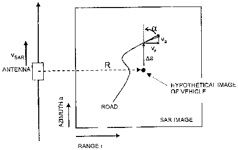
With regard to the above, Fig. 1 schematically illustrates the vehicle
s misrepresentations in a usual conventional SAR Image. As schematically
outlined in this Figure, a moving vehicle imaged by Synthetic aperture radar
is displaced in flight direction relative to the stationary background, is
blurred in the azimuth direction and is possibly imaged several times
(ambiguity).
For the above reasons, in radar systems which have been designed for
imaging stationary objects, the processing of the data and the detection of
vehicles is impeded by considerable difficulties.
is Therefore, and also because of the relatively low resolution of present-day
civil radar systems, the detection of moving vehicles - also referred to as
GMTI (Ground Moving Target Indication) - is of highly topical relevance on
the military sector. On this sector, use is made of airplane-based radar
systems which have been optimized for GMTI. To facilitate the detection of
moving objects, these systems have e.g. a plurality of antennae, a
considerably increased pulse repetition frequency and a stronger
transmitting power.
To make it possible to locate, in a radar field, the signal of a vehicle which
is
weak in comparison with the background, the vehicle has to be focused in
an optimum manner, i.e. its whole energy should be concentrated onto one
image point. Because of the above mentioned effects, however, it is
necessitated that the position, the speed and the direction of the vehicle are
known already before the processing.
A relatively obvious but very complex solution to this problem would reside
in generating, in a first step, respectively one image for all possible
combinations of radial and azimuth speeds (v,- and va) and, in a second
CA 02579898 2007-02-23
4
step, searching the vehicles in the resultant stack of images. However, the
number of images required for this approach could be in the magnitude of
several hundreds. Generating these images would require massive
computational expenditure, and the numerical processing to be further
performed on these images, e.g. the detection of a vehicle in this stack of
images, is complicated as well. Also a visual evaluation of such a large
quantity of image is unrealistic.
To sum up, it is to be stated that the detection of moving objects in SAR
io images is very difficult because such objects will appear shifted as
compared to stationary objects and because, due to their self-focusing, they
will be focused in a non-sharp manner.
Thus, it is an object of the present invention to detect moving vehicles,
particularly road and rail vehicles, by means of airplane- or space-based
synthetic aperture radar sensor systems (SAR) in a better manner while
requiring less expenditure regarding personnel and technical apparatus.
According to the invention, which relates to a method for the processing
and representing of ground images obtained by airplane- or space-based
synthetic aperture radar sensor systems (SAR), the above object is
achieved in that a known traffic route of a map, which is given by
geographic coordinates and altitudes, is converted into azimuth/range
coordinates of the SAR radar image, that the hypothetical radial speed of
each image point of vehicles of potential relevance is determined from the
distance of the image point to a traffic route in the azimuth direction and
the appertaining vehicle image position is determined by azimuth projection
onto the respective traffic route, and that, from this hypothetical vehicle
radial speed, a first focusing parameter AFDC for the focusing is derived in
dependence on the radar parameters, and that, from the hypothetical
vehicle radial speed, the angle of incidence of the radar beam onto the
surface of the earth and the angle between the respective traffic route and
the flight path of the radar sensor, the hypothetical vehicle azimuth speed is
CA 02579898 2007-02-23
derived and, therefrom, by inclusion of the flight path of the radar sensor
and the radar parameters, a second focusing parameter LFM is derived, and
that the two focusing parameters AfDC and dFM derived from the
hypothetical radial and azimuth speeds are plotted in a matrix and are used
5 for exact adjustment of the SAR focusing to the moving object.
The invention utilizes the already existing knowledge about the traffic route
for a precise and effective focusing as well as for a form of representation
which considerably facilitates the interpretation of the SAR radar images.
1.0
The invention is distinguished in that digital maps of traffic routes, i.e.
particularly digital road maps, railroad maps or river route maps, will be
included into the SAR focusing. In doing so, the traffic route is transformed
into the radar image geometry. Then, the vehicle radar speed of each image
point is determined on the basis of the distance from the image point to the
traffic route in the azimuth direction and of the appertaining vehicle
position
by azimuth projection onto the road. Subsequently, the azimuth speed is
detected on the basis of the above radial speed and the road angle. Finally,
on the basis of the detected radial and azimuth speeds, there is performed
a precise and efficient focusing of the individual image point which
corresponds to a moving object, i.e. a moving vehicle.
The advantages of the method performed according to the present invention
reside primarily in that only one SAR image has to be generated and to be
searched for vehicles, thus accomplishing considerable time-saving and
simplification. Each vehicle is subjected to optimum focusing, with a
resultant increase of the vehicle-detection probability. The clutter for
quickly
moving objects will be reduced In contrast and for certain speed ranges will
become darker, again with a resultant increase of the vehicle-detection
probability. Finally, when using of the method of the present invention, the
image can be easily and quickly be interpreted by an evaluating person.
CA 02579898 2007-02-23
6
Further advantageous and suitable embodiments of the invention are
indicated in the claims directly or indirectly depending on claim 1.
The focusing of the individual image point or its surroundings under
consideration of the radial and azimuth speeds can be advantageously
performed in the time domain using an adaptive time domain correlator.
Alternatively, using standard SAR processors, the focusing of a plurality of
images with different speed parameters (vr,v,) can be performed together
in advance, while only image regions near roads will be focused. Then,
there will be performed a combination into an image, wherein each image
point is taken from the image which corresponds to the hypothetical radial
and azimuth speeds.
According to a further alternative, a prefocusing of the image by use of a
modified standard SAR processor and a refocusing by use of a position-
adaptive correction filter can be performed in the time domain. The
modification of a standard SAR processor consists in the internal replication
of the azimuth spectrum.
_
A further embodiment of the invention resides in the representation only of
the road route, i.e. not of the whole picture, with speed contours for visual
evaluations by persons.
Advantageously, one can obtain a colored representation of the
interferometric SAR image with overlying colored speed structures for multi-
channel systems (ATI - Along-Track Interfermometry).
Further, the method of the present invention advantageously allows for a
colored representation of the SAR image with overlying colored speed
structures for DPCA (Displaced Phase Center Antenna) systems, i.e.
systems comprising an antenna with two or more shifted phase centers,
CA 02579898 2007-02-23
7
The method of the present invention is applicable in a particularly
advantageous manner in the detection, use and marketing of traffic data for
scientific, economical and safety-related purposes and in the generating of
easily surveyable images of traffic flows.
The invention will be explained in greater detail hereunder with reference to
the accompanying drawings and diagrams. Shown therein is the following:
Fig. 1 shows the already described schematic representation for pointing
1.0 out the difficulties occurring in the imaging of moving vehicles by
means of normal conventional SAR systems, which difficulties reside
in that the image points representing the vehicles are displaced in
flight direction relative to the stationary background, are blurred in
the azimuth and are possibly rendered by multiple images
2s (ambiguity);
Fig. 2 shows a schematic representation for visualizing the map-controlled
speed-dependent SAR focusing according to the method of the
present invention;
Fig. 3 shows a schematic representation of an SAR image with ISO speeds
subjected to speed-dependent focusing according to the method of
the present invention;
Fig. 4 shows a flow chart of a speed-dependent SAR process performed
according to the method of the present invention with subsequent
SAR processing in a first variant (variant a) using a visualization by
means of an adaptive time domain correlator;
Fig. 5 shows a flow chart of a speed-dependent SAR process performed
according to the method of the present invention with subsequent
SAR processing in a second variant (variant b) using a visualization
by means of standard SAR processor;
CA 02579898 2007-02-23
8
Fig. 6 shows a flow chart of a speed-dependent SAR process performed
according to the method of the present invention with subsequent
SAR processing in a third variant (variant c) using a visualization by
s means of standard SAR processor and adaptive refocusing; and
Fig. 7 shows four examples of images rendered by a prototype of a
processor, Fig. 7a showing a conventional SAR image presenting a
road and superimposed ISO speed lines, Fig. 7b showing a
conventional SAR image of the relevant region image presenting a
road and superimposed ISO speed lines, Fig. 7c showing an SAR
image with speed-adaptive focusing, presenting a road and
superimposed ISO speed lines, and Fig. 7d showing an SAR Image
with speed-adaptive focusing, with superimposed interferometric
1s phase, road and ISO speed lines, the interferometric phase being
superimposed in colored representation.
The principle of the method for the processing and representing of the SAR
images according to the present invention will be demonstrated and
explained hereunder with reference to Fig. 2. The processing is considerably
simplified by the novel combination of two approaches.
The road network is known. Thus, according to the first approach, the space
of solutions can be considerably restricted. According to the present
invention, this is performed in that the road route, given by geographic
coordinates and altitudes { (x, y, z), ... ; , is converted into the
azimuth/range coordinates of the radar image { (a, r), ... I.
According to a second approach, the SAR focusing is controlled by reverse
projection. In this approach, the treatment each possibly relevant image
point will be based on the hypothesis that this image point is the
representation of a vehicle. First, there is determined the distance a from
the point to the assumed traffic route (e.g. road, rail) in the flight
direction
CA 02579898 2007-02-23
9
of the airplane- or space-based SAR sensor. From this distance, both the
position of the vehicle on the road and its radial speed Vr can be derived.
Here, R denotes the distance between the antenna and the point, and VsAR
denotes the speed of the SAR antenna:
Aa
yr = R 1'.C-0R
For focusing, it easily possible to derive, from the hypothetical radial speed
yr and in dependence on the radar parameters, the proportional correction
parameter AMC, i.e. the displacement of the azimuth spectrum as
compared to the stationary earth. With the aid of the angle of incidence 8 of
the radar beam onto the earth's surface and the angle a between the road
and the flight path of the radar sensor, one can determine, from the radial
speed v,, also the hypothetical azimuth speed v3 and, therefrom, with the
aid of the flight path and the radar parameters of the second focusing
parameters, one can determine the change of the frequency modulation
rate 1FM. However, this will not be feasible in case of movements which are
nearly parallel to the fight path with a _= 0.
The two parameters dfDC and AFM derived from.the hypothetical radial and
azimuth speeds yr and v, are plotted in a matrix and are used for exact
adjustment of the SAR focusing to the moving object. Thereby, it is
safeguarded that the hypothetical vehicle will be optimally focused. In case
that the above hypothesis does not hold true, he. the image point does not
include a vehicle, the stationary background is defocused, which, however,
is not relevant for the detection of the vehicle. In the map, there have also
been marked those regions which need not be processed at all because the
displacement towards the closest road would correspond to an unrealistic
speed.
The focusing parameter map is generated according to the flow charts
outlined in Figs. 4 to 6 in the manner explained hereunder:
CA 02579898 2007-02-23
The road route is extracted from a digital road route database in the
form of segments or a three-dimensional sequence of points {x, y, z}.
5 The segments and the sequence of points { (x, y, z), ... },
respectively, are transformed into the azimuth/range radar coordinate
system { (as, r5i) ... }
From the segments, there is interpolated a nearly continuous course
zo for each pixel of the radar image. This road route will finally be
additionally superimposed to the radar image for visual evaluation.
For each pixel in the range, the maximum range of displacement in the
azimuth direction is now determined on the basis of an assumed
is maximum vehicle speed Vmax, This maximum displacement range
depends on the angle of incidence 6 and the local road angle a:
Lt = V,rti,.Y sin(a)cos(q) R
V SAR
For each roadway position {as, rj, the vehicle can be imaged only into
the range { [a.-Damax, aE+iam ] , r.).
Now, for each possible image point {a, r} within the range { [a3-
Damax, ao oama,,] , rs}, the radial speed yr and the azimuth speed vv
are computed:
a-as
V'a =
tan a = cos 6
CA 02579898 2007-02-23
Obtained from these parameters are the focusing film parameters AFDC and
LFM which will be used to adjust the SAR processor for the speed which is
to be expected, This pair of focusing parameters is computed for each
possibly relevant image point near the road,
The parameter AFDC can be derived in a simple manner from the radial
speed võ as follows:
AJDC J AV,
wherein h is the wavelength of the radar.
The FM rate of a constantly moving vehicle having the azimuth speed
component ve at a linear flight path of the SAR is computed as:
z 2 2
FAlr = --- (v$AR - vn) = -2 V,An --(v,2 - 2vsau va) =FM, + AFAM
a AR AR
so that the additional FM rate caused by the vehicle will be.
LFM = -R (v2 - 2i.san vQ )
If the vehicle does not move linearly with constant speed, i.e. if the vehicle
is accelerated in a radial direction relative to the radar antenna, this will
result in further influences on the frequency modulation rate AFM, with the
consequence that the image of the vehicle will be defocused in the azimuth.
If such an acceleration component is caused by the vehicle's following a
curved route at constant speed, the resultant defocusing can be
compensated for by means of a slight modification of the method. For this
CA 02579898 2007-02-23
12
purpose, using a numerical derivation of the radial component of the speed,
the radial acceleration is computed:
__ dy,
yr dt
This radial component will effect a further correction of the frequency
modulation rate AFM,,C. For vehicles undergoing a radial change of speed,
i.e. a radial acceleration v,. relative to the sensor, the acceleration
parameter will be included In the quadratic distance function, resulting in a
further influence on the FM rate:
t0
or a,:~ _ ~ v,
The frequency modulation rate correction to be considered in the focusing
comprises the correction for the azimuth speed and the correction for the
radial acceleration:
AFJ;1~S02-,r, = 4F + AFS'~fy Q,,
At the same time, the extreme values AfDC_m,,, AFDC ma,., dx'M,,,,,r, and
AFKõax are obtained for the whole course of the road.
For the realization of the subsequent SAR processing, three variants a), b)
and c) are proposed according the invention, to be described hereunder
with reference to Figs. 4 to 6.
Variant a): Use is made of a special time range correlator which, for
focusing each individual image point, will correlate the SAR raw data using a
two-dimensional correlation core, According to the invention, this
correlation core will be adapted for each image point with the aid of the two
3o focusing parameters AFDC and AFM and thus allow for an optimum
CA 02579898 2007-02-23
13
movement-adaptive image of the road and of the vehicles driving on it.
From the potentially relevant speeds and positions, a control mask is
computed, To save time, the image will be focused only for those areas
which have been marked in the control mask. This image is mathematically
exact and thus optimally focused..This variant is schematically shown in the
flow chart of Fig. 4. Depending on the prevailing circumstances, the
computation may take a longer time than the generating of a plurality of
images by means of standard SAR processors which is described hereunder
as variant b).
Variant b): In this variant, standard SAR processors are used. The range
[afDCmin, dfDCmax! is discretized into N intervals, and the range [l1FMmin,
,4FMmax1 is discretized into M intervals, the interval boundaries being
selected in such a manner that the processing errors caused by the
is discretizing will be tolerable. The average values of the intervals are
orthogonally entered into a two-dimensional discretizing table. For each
element of the discretizing table, which has a size Z = N x M, the matrix of
the focusing parameters is searched for pairs of values which belong into
this discretizing interval. The result resides in Z control masks which will
instruct the SAR processor as to what image portions have to be processed
at all. As Fig. 5 shows, Z images covering all required Z combinations of
focusing parameters, are processed in Z standard SAR processors which are
connected in parallel or are arranged behind each other in the computer. It
is advantageous if a standard SAR processor is slightly modified. By such a
modified standard SAR processor, those processing steps which are
independent from the parameters AMC and LFM will be carried out only
once, and all subsequent processing steps will be carried out Z times with
adapted parameters. The processor will process for each image according to
the invention only the image points marked in the control mask, thus saving
considerable computational time. Now, there have been obtained Z partial
images which, with the aid of the Z control masks, will be assembled again
into one image. The result of this process is an image of the road and its
surroundings as obtained by variant a) with the time domain correlator.
CA 02579898 2007-02-23
14
Variant c): A standard SAR processor will process the scene using the
average focusing parameters iDC and 6FM, i.e. the parameters normally
related to the stationary scene, which have been taken from the discretizing
s table. In this first step, the focusing artifacts caused by the movement
will
be tolerated. Additionally, a modification is performed which resides in that,
prior to the focusing, the signal spectrum is replicated in azimuth to the
effect that also moving objects are correctly processed by the processor
with regard to their spectrum and their range migration. The azimuth
1.0 bandwidth of the processor will be correspondingly widely dimensioned for
the following processing. Thus, the focused image includes the image of
vehicles and clutter as well as their spectrally and spatially shifted
versions.
Then, in a position-adaptive post-processing step, the remaining movement
unsharpness LFM is corrected in the azimuth direction, and the azimuth
1s spectrum of the expected image is filtered out. The filtering can be
performed in the time domain or by fast convolution. Also in this variant, a
control mask is used for processing only the necessary image portions. Fig.
6 shows a schematic flowchart of this speed-adaptive SAR process
performed according to the method of the invention, with subsequent SAR
20 processing according to variant c) by use of visualization with the aid of
a
standard SAR processor and adaptive refocusing.
For interferometric multi-antennae-systems, the computation of the control
masks and of the speed-depedent parameters is carried out only once, and
25 the actual SAR processing is performed separately for each antenna channel
of the system.
An advantageous embodiment of the method of the present invention
resides in a novel representation of the image for the purposes of visual
30 evaluation. For this representation, both the road route and the lines of
the
same speed are superimposed onto the SAR Image generated according to
the above description. The azimuth displacement for a constant speed V,so is
CA 02579898 2007-02-23
computed, for each point of the road in the range, on the basis of the
following equation:
Da = vsQ sin(a)cog(0) R
VSAR
5
These lines of identical speeds (ISO speed lines) are superimposed onto the
SAR image like contour lines on a topographic map. Fig. 3 shows a
schematic representation of an SAR image with speed-dependent focusing
which is provided with ISO speed lines.
,13
In case of an interferometric SAR corresponding to along-track interfermo-
metry (ATI), the lines will be plotted advantageously in colored
representation corresponding to the expected interferometric phase. The
SAR image will be generated from the two existing antenna channels and be
is colored corresponding to the interferometric phase difference between the
two channels. The visual evaluation will now be performed as follows: Bright
points are assumed to represent vehicles, and their speeds will be
estimated on the basis of the closest ISO speed lines. In case of ATI
processing, it is additionally provided that the color (= phase) of the point
is
compared to the color of the closest ISO speed line. Thus, if the speed
derived from the displacement and the speed derived from the color
coincide with each other, a very high likelihood exists that there really
occurs a movement with this speed. Further, the problem of ambiguities can
be eliminated if the speed ambiguity intervals of the phase and of the pulse
repetition frequency are different.
An alternative method for along-track interfermometry (ATI) consists in the
subtraction of the results of the two antenna channels, also referred to as
DPCA (Displaced Phase Center Antenna). Here, not the phase difference but
the difference of the complex images of both antennae is generated. In the
ideal case, the stationary background (clutter) is eliminated in the process,
and the moving vehicles will be maintained as bright points. Also this image
CA 02579898 2007-02-23
16
is suitably represented with superimposed road routes and lines of identical
speeds.
The thus generated image is much better suited for interpretation than a
s standard SAR image focused with constant parameters or even just a stack
of images because, here, only one band along the road has to be evaluated
in a single image and the visual evaluation is supported by the speed
contours.
In Fig. 7, four examples of images obtained from data of the Shuttle Radar
Topography Mission (SRTM) are schematically illustrated. In the
conventional standard SAR image according to Fig. 7a, the vehicles and the
road can be made out only with difficulties. The superimposed ISO speed
lines representing multiples of 50 km/h are already helpful in the
1s interpretation of the SAR image, Still more easily surveyable is the
variant
according to Fig. 7b wherein only the relevant range has been focused,
while also saving computational time. Fig. 7c illustrates the overall SAR
image with exclusively speed-adaptive focusing and with superimposed ISO
speed lines. Thus, the stationary clutter in the region of the road has an
ambiguous appearance. For certain speed ranges outside of the clutter
spectrum, the vehicles are now visualized much brighter. In Fig. 7d, the
SAR image and the ISO speed lines are colored with respect to their
interferometric phase. In this manner, it is also possible to eliminate
ambiguities.